Bridge Statistics for Tualatin, Oregon (OR)
Condition, Traffic, Stress, Structural Evaluation, Project Costs
- National Bridge Inventory (NBI) Statistics
- 34Number of bridges
- 643ft / 196mTotal length
- $6,525,000Total costs
- 1,583,259Total average daily traffic
- 176,093Total average daily truck traffic
- National Bridge Inventory (NBI) Registered Bridges for Tualatin
- No street view available for this location
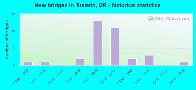
- New bridges - historical statistics
- 11920-1929
- 11930-1939
- 21950-1959
- 131960-1969
- 111970-1979
- 21980-1989
- 31990-1999
- 12010-2019

- Reconstructed bridges - Historical Statistics
- 21980-1989
- 01990-1999
- 12000-2009


- Bridge Condition - Deck
- 4.3%Very good
- 21.7%Good
- 65.2%Satisfactory
- 8.7%Fair

- Bridge Condition - Superstructure
- 8.7%Very good
- 30.4%Good
- 56.5%Satisfactory
- 4.3%Fair

- Bridge Condition - Substructure
- 4.3%Very good
- 26.1%Good
- 69.6%Satisfactory

- Bridge Condition - Channel
- 64.3%Very good
- 21.4%Good
- 14.3%Satisfactory
Find on map >> Show street view
Structure Number: 1417N01W 01218, Location: 0.5 MI S OF KING CITY CC (Lat: 45.394131, Lng: -122.798981), Route carried "on" structure: State highway 99, Year Built: 1955, Status: Open, Structure Length: 14.12m (46.33ft), Average Daily Traffic: 13,883 (year 2020), Truck Traffic: 4%, Average Future Daily Traffic: 19,550 (year 2040), Design Load: HS 20, Features Intersected: TUALATIN RIVER
Minimum Vertical Clearance: 30+ m (98+ ft), Kilometerpoint: 19.602, Lanes on structure: 2, Base Highway Network: Yes, Owner: State Highway Agency, Approaching Roadway Width: 9.0m (29.5ft), Material/Design: Concrete continuous, Design/Construction: Girder and Floorbeam System, Number Of Spans In Main Unit: 7, Length of Maximum Span: 30.5m (100.1ft), Curb or Sidewalk Widths: Left: 0.8m (2.6ft), Right: 0.0m, Curb-To-Curb Width: 9.0m (29.5ft), Out-to-Out Width: 11.3m (37.1ft)
Condition: Deck: Fair, Superstructure: Satisfactory, Substructure: Satisfactory, Channel: Good, Operating Rating: 28.2 metric tons, Method Used To Determine Operating Rating: Load and Resistance Factor Rating (LRFR) rating reported by rating factor(RF) method using HL-93 loadings, Inventory Rating: 21.7 metric tons, Method Used To Determine Inventory Rating: Load and Resistance Factor Rating (LRFR) rating reported by rating factor(RF) method using HL-93 loadings, Structural Evaluation: Somewhat better than minimum adequacy, Deck Geometry: High priority of corrective action, Waterway Adequacy: Equal to present desirable criteria, Approach Roadway Alignment: Equal to present desirable criteria, Designated Inspection Frequency: Every 24 months, Underwater Inspection Frequency: Every 60 months, Inspection Date: Febuary 2020, Underwater Inspection Date: May 2019, Deck Structure Type: Concrete Cast-file-Place, Wearing Surface/Protective System: Wearing Surface: Latex Concrete
Find on map >> Show street view
Structure Number: 1417S01W 0122, Location: 0.5 MI S OF KING CITY CC (Lat: 45.394039, Lng: -122.799350), Route carried "on" structure: State highway 99, Year Built: 1929, Status: Open, Structure Length: 15.65m (51.35ft), Average Daily Traffic: 13,883 (year 2020), Truck Traffic: 4%, Average Future Daily Traffic: 19,550 (year 2040), Design Load: HS 20, Features Intersected: TUALATIN RIVER, Facility Carried by Structure: HWY 1W SB
Minimum Vertical Clearance: 30+ m (98+ ft), Kilometerpoint: 19.634, Lanes on structure: 2, Base Highway Network: Yes, Owner: State Highway Agency, Approaching Roadway Width: 8.2m (26.9ft), Material/Design: Steel, Design/Construction: Truss - Deck, Number Of Spans In Main Unit: 1, Number Of Approach Spans: 9, Length of Maximum Span: 45.7m (149.9ft), Curb or Sidewalk Widths: Left: 1.5m (4.9ft), Right: 1.5m (4.9ft), Curb-To-Curb Width: 8.2m (26.9ft), Out-to-Out Width: 12.0m (39.4ft)
Condition: Deck: Fair, Superstructure: Satisfactory, Substructure: Satisfactory, Channel: Good, Operating Rating: 21.1 metric tons, Method Used To Determine Operating Rating: Load and Resistance Factor Rating (LRFR) rating reported by rating factor(RF) method using HL-93 loadings, Inventory Rating: 16.2 metric tons, Method Used To Determine Inventory Rating: Load and Resistance Factor Rating (LRFR) rating reported by rating factor(RF) method using HL-93 loadings, Structural Evaluation: Meets minimum limits, Deck Geometry: High priority of corrective action, Waterway Adequacy: Equal to present desirable criteria, Approach Roadway Alignment: Equal to present desirable criteria, Length Of Structure Improvement: 15.60m (51.18ft), Designated Inspection Frequency: Every 24 months, Critical Feature Inspection Frequency: Every 24 months, Underwater Inspection Frequency: Every 60 months, Inspection Date: Febuary 2020, Critical Feature Inspection Date: January 2020, Underwater Inspection Date: May 2019, Bridge Improvement Cost: $1,644,000, Roadway Improvement Cost: $164,000, Total Project Cost: $2,630,000, Deck Structure Type: Concrete Cast-file-Place, Wearing Surface/Protective System: Wearing Surface: Bituminous, Membrane: Epoxy
Find on map >> Show street view
Structure Number: 1578 01W 01382, Location: 14 MI. N. OF SHERWOOD (Lat: 45.381850, Lng: -122.826761), Route carried "on" structure: State highway 99, Year Built: 1931, Status: Open, Structure Length: 3.66m (12.01ft), Average Daily Traffic: 14,438 (year 2020), Truck Traffic: 4%, Average Future Daily Traffic: 19,150 (year 2040), Design Load: H 15, Features Intersected: ROCK CREEK (ONION FLAT)
Minimum Vertical Clearance: 30+ m (98+ ft), Kilometerpoint: 22.241, Lanes on structure: 2, Base Highway Network: Yes, Owner: State Highway Agency, Approaching Roadway Width: 9.1m (29.9ft), Material/Design: Concrete continuous, Design/Construction: Tee Beam, Number Of Spans In Main Unit: 3, Length of Maximum Span: 14.0m (45.9ft), Curb or Sidewalk Widths: Left: 1.5m (4.9ft), Right: 1.5m (4.9ft), Curb-To-Curb Width: 9.1m (29.9ft), Out-to-Out Width: 12.9m (42.3ft)
Condition: Deck: Satisfactory, Superstructure: Satisfactory, Substructure: Satisfactory, Channel: Very good, Operating Rating: 24.9 metric tons, Method Used To Determine Operating Rating: Load and Resistance Factor Rating (LRFR) rating reported by rating factor(RF) method using HL-93 loadings, Inventory Rating: 19.1 metric tons, Method Used To Determine Inventory Rating: Load and Resistance Factor Rating (LRFR) rating reported by rating factor(RF) method using HL-93 loadings, Structural Evaluation: Meets minimum limits, Deck Geometry: Meets minimum limits, Waterway Adequacy: Equal to present desirable criteria, Approach Roadway Alignment: Equal to present desirable criteria, Designated Inspection Frequency: Every 24 months, Inspection Date: Febuary 2020, Deck Structure Type: Concrete Cast-file-Place, Wearing Surface/Protective System: Wearing Surface: Bituminous, Membrane: Epoxy
Find on map >> Show street view
Structure Number: 1578A01W 01383, Location: 014 MI N SHERWOOD (Lat: 45.381589, Lng: -122.826781), Route carried "on" structure: State highway 99, Year Built: 1955, Status: Open, Structure Length: 3.66m (12.01ft), Average Daily Traffic: 14,438 (year 2020), Truck Traffic: 4%, Average Future Daily Traffic: 19,150 (year 2040), Design Load: HS 20, Features Intersected: ROCK CREEK (ONION FLAT)
Minimum Vertical Clearance: 30+ m (98+ ft), Kilometerpoint: 22.257, Lanes on structure: 2, Base Highway Network: Yes, Owner: State Highway Agency, Approaching Roadway Width: 11.0m (36.1ft), Material/Design: Concrete continuous, Design/Construction: Tee Beam, Number Of Spans In Main Unit: 3, Length of Maximum Span: 14.6m (47.9ft), Curb-To-Curb Width: 11.0m (36.1ft), Out-to-Out Width: 12.4m (40.7ft)
Condition: Deck: Satisfactory, Superstructure: Satisfactory, Substructure: Satisfactory, Channel: Very good, Operating Rating: 21.4 metric tons, Method Used To Determine Operating Rating: Load and Resistance Factor Rating (LRFR) rating reported by rating factor(RF) method using HL-93 loadings, Inventory Rating: 16.5 metric tons, Method Used To Determine Inventory Rating: Load and Resistance Factor Rating (LRFR) rating reported by rating factor(RF) method using HL-93 loadings, Structural Evaluation: Meets minimum limits, Deck Geometry: Equal to present minimum criteria, Waterway Adequacy: Equal to present desirable criteria, Approach Roadway Alignment: Equal to present desirable criteria, Designated Inspection Frequency: Every 24 months, Inspection Date: Febuary 2020, Deck Structure Type: Concrete Cast-file-Place, Wearing Surface/Protective System: Wearing Surface: Bituminous, Membrane: Epoxy
Find on map >> Show street view
Structure Number: 2376B001 28951, Location: AT TUALATIN RIVER (Lat: 45.387594, Lng: -122.750661), Route carried "on" structure: Interstate 5, Year Built: 1975, Year Reconstructed: 1991, Status: Open, Structure Length: 7.92m (25.98ft), Average Daily Traffic: 139,488 (year 2020), Truck Traffic: 11%, Average Future Daily Traffic: 194,200 (year 2040), Design Load: HS 20, Features Intersected: TUALATIN RIVER
Minimum Vertical Clearance: 30+ m (98+ ft), Kilometerpoint: 466.468, Lanes on structure: 8, Base Highway Network: Yes, Owner: State Highway Agency, Approaching Roadway Width: 47.2m (154.9ft), Skew: 30 degrees, Navigation Control: Yes ( Vertical Clearance: 7.6m (24.9ft), Horizontal Clearance: 28.7m (94.2ft)), Material/Design: Prestressed concrete, Design/Construction: Stringer/Multi-beam, Number Of Spans In Main Unit: 3, Length of Maximum Span: 30.5m (100.1ft), Curb-To-Curb Width: 47.2m (154.9ft), Out-to-Out Width: 48.7m (159.8ft)
Condition: Deck: Satisfactory, Superstructure: Good, Substructure: Satisfactory, Channel: Very good, Operating Rating: 25.6 metric tons, Method Used To Determine Operating Rating: Load and Resistance Factor Rating (LRFR) rating reported by rating factor(RF) method using HL-93 loadings, Inventory Rating: 19.8 metric tons, Method Used To Determine Inventory Rating: Load and Resistance Factor Rating (LRFR) rating reported by rating factor(RF) method using HL-93 loadings, Structural Evaluation: Somewhat better than minimum adequacy, Deck Geometry: Superior to present desirable criteria, Waterway Adequacy: Better than present minimum criteria, Approach Roadway Alignment: Equal to present desirable criteria, Designated Inspection Frequency: Every 24 months, Underwater Inspection Frequency: Every 60 months, Inspection Date: January 2022, Underwater Inspection Date: June 2019, Deck Structure Type: Concrete Cast-file-Place, Wearing Surface/Protective System: Wearing Surface: Epoxy Overlay, Deck Protection: Epoxy Coated Reinforcing
Find on map >> Show street view
Structure Number: 4970B141 00888, Location: 4.0 MI N OF HWY 1 (Lat: 45.386064, Lng: -122.757469), Route carried "on" structure: State highway 141, Year Built: 1967, Status: Open, Structure Length: 9.63m (31.59ft), Average Daily Traffic: 20,550 (year 2020), Truck Traffic: 3%, Average Future Daily Traffic: 36,600 (year 2040), Design Load: HS 20, Features Intersected: TUALATIN RIVER
Minimum Vertical Clearance: 30+ m (98+ ft), Kilometerpoint: 14.291, Lanes on structure: 2, Owner: State Highway Agency, Approaching Roadway Width: 10.7m (35.1ft), Material/Design: Prestressed concrete, Design/Construction: Stringer/Multi-beam, Number Of Spans In Main Unit: 3, Length of Maximum Span: 32.2m (105.6ft), Curb or Sidewalk Widths: Left: 1.6m (5.2ft), Right: 1.6m (5.2ft), Curb-To-Curb Width: 10.7m (35.1ft), Out-to-Out Width: 15.2m (49.9ft)
Condition: Deck: Satisfactory, Superstructure: Good, Substructure: Satisfactory, Channel: Good, Operating Rating: 88.9 metric tons, Method Used To Determine Operating Rating: Load Factor (LF), Inventory Rating: 53.5 metric tons, Method Used To Determine Inventory Rating: Load Factor (LF), Structural Evaluation: Equal to present minimum criteria, Deck Geometry: Meets minimum limits, Waterway Adequacy: Equal to present desirable criteria, Approach Roadway Alignment: Equal to present desirable criteria, Designated Inspection Frequency: Every 24 months, Underwater Inspection Frequency: Every 60 months, Inspection Date: December 2021, Underwater Inspection Date: June 2019, Deck Structure Type: Concrete Cast-file-Place, Wearing Surface/Protective System: Wearing Surface: Monolithic Concrete
Find on map >> Show street view
Structure Number: 7494B001 28938, Location: 0.5 MI S OF TUALATIN R. (Lat: 45.380911, Lng: -122.753408), Route carried "on" structure: Interstate 5, Year Built: 1975, Status: Open, Structure Length: 4.27m (14.01ft), Average Daily Traffic: 69,744 (year 2020), Truck Traffic: 11%, Average Future Daily Traffic: 97,100 (year 2040), Design Load: HS 20, Features Intersected: BEAVER DAM CREEK
Minimum Vertical Clearance: 30+ m (98+ ft), Kilometerpoint: 465.712, Lanes on structure: 4, Base Highway Network: Yes, Owner: State Highway Agency, Approaching Roadway Width: 27.3m (89.6ft), Material/Design: Concrete continuous, Design/Construction: Slab, Number Of Spans In Main Unit: 3, Length of Maximum Span: 17.1m (56.1ft), Curb-To-Curb Width: 27.3m (89.6ft), Out-to-Out Width: 28.4m (93.2ft)
Condition: Deck: Good, Superstructure: Good, Substructure: Satisfactory, Channel: Very good, Operating Rating: 69.0 metric tons, Method Used To Determine Operating Rating: Load and Resistance Factor Rating (LRFR) rating reported by rating factor(RF) method using HL-93 loadings, Inventory Rating: 53.1 metric tons, Method Used To Determine Inventory Rating: Load and Resistance Factor Rating (LRFR) rating reported by rating factor(RF) method using HL-93 loadings, Structural Evaluation: Equal to present minimum criteria, Deck Geometry: Superior to present desirable criteria, Waterway Adequacy: Equal to present desirable criteria, Approach Roadway Alignment: Equal to present desirable criteria, Designated Inspection Frequency: Every 24 months, Inspection Date: January 2020, Deck Structure Type: Concrete Cast-file-Place, Wearing Surface/Protective System: Wearing Surface: Bituminous
Find on map >> Show street view
Structure Number: 7494C001 28938, Location: 0.5 MI S OF TUALATIN R. (Lat: 45.380903, Lng: -122.752928), Route carried "on" structure: Interstate 5, Year Built: 1975, Year Reconstructed: 1991, Status: Open, Structure Length: 4.27m (14.01ft), Average Daily Traffic: 69,744 (year 2020), Truck Traffic: 11%, Average Future Daily Traffic: 97,100 (year 2040), Design Load: HS 20, Features Intersected: BEAVER DAM CREEK
Minimum Vertical Clearance: 30+ m (98+ ft), Kilometerpoint: 465.712, Lanes on structure: 3, Base Highway Network: Yes, Owner: State Highway Agency, Approaching Roadway Width: 18.7m (61.4ft), Material/Design: Concrete continuous, Design/Construction: Slab, Number Of Spans In Main Unit: 3, Length of Maximum Span: 17.1m (56.1ft), Curb-To-Curb Width: 24.1m (79.1ft), Out-to-Out Width: 25.8m (84.6ft)
Condition: Deck: Satisfactory, Superstructure: Satisfactory, Substructure: Good, Channel: Very good, Operating Rating: 32.1 metric tons, Method Used To Determine Operating Rating: Load and Resistance Factor Rating (LRFR) rating reported by rating factor(RF) method using HL-93 loadings, Inventory Rating: 24.6 metric tons, Method Used To Determine Inventory Rating: Load and Resistance Factor Rating (LRFR) rating reported by rating factor(RF) method using HL-93 loadings, Structural Evaluation: Equal to present minimum criteria, Deck Geometry: Superior to present desirable criteria, Waterway Adequacy: Equal to present desirable criteria, Approach Roadway Alignment: Equal to present desirable criteria, Designated Inspection Frequency: Every 24 months, Inspection Date: January 2022, Deck Structure Type: Concrete Cast-file-Place, Wearing Surface/Protective System: Wearing Surface: Bituminous
Find on map >> Show street view
Structure Number: 7575A001 28742, Location: 2.4 MI S OF TUALATIN R. (Lat: 45.353739, Lng: -122.764111), Route carried "on" structure: County highway , Year Built: 1969, Status: Open, Structure Length: 8.93m (29.30ft), Average Daily Traffic: 1,618 (year 2010), Truck Traffic: 5%, Average Future Daily Traffic: 3,016 (year 2030), Design Load: HS 20, Features Intersected: PACIFIC HWY 1 (I-5), Facility Carried by Structure: NORWOOD ROAD
Minimum Vertical Clearance: 30+ m (98+ ft), Kilometerpoint: 462.558, Lanes on structure: 2, Lanes under structure: 8, Owner: State Highway Agency, Approaching Roadway Width: 12.2m (40.0ft), Skew: 1 degrees, Material/Design: Steel continuous, Design/Construction: Frame, Number Of Spans In Main Unit: 5, Length of Maximum Span: 28.0m (91.9ft), Curb-To-Curb Width: 12.2m (40.0ft), Out-to-Out Width: 13.0m (42.7ft)
Condition: Deck: Satisfactory, Superstructure: Satisfactory, Substructure: Satisfactory, Operating Rating: 48.3 metric tons, Method Used To Determine Operating Rating: Load and Resistance Factor Rating (LRFR) rating reported by rating factor(RF) method using HL-93 loadings, Inventory Rating: 37.3 metric tons, Method Used To Determine Inventory Rating: Load and Resistance Factor Rating (LRFR) rating reported by rating factor(RF) method using HL-93 loadings, Structural Evaluation: Equal to present minimum criteria, Deck Geometry: Better than present minimum criteria, Underclear: Equal to present minimum criteria, Approach Roadway Alignment: Equal to present desirable criteria, Designated Inspection Frequency: Every 24 months, Inspection Date: January 2020, Deck Structure Type: Concrete Cast-file-Place, Wearing Surface/Protective System: Wearing Surface: Monolithic Concrete
Find on map >> Show street view
Structure Number: 7582A001C2895, Location: 0.4 MI S OF TUALATIN RV (Lat: 45.382664, Lng: -122.752458), Route carried "on" structure: Interstate 5, Year Built: 1975, Year Reconstructed: 2005, Status: Open, Structure Length: 8.05m (26.41ft), Average Daily Traffic: 28,394 (year 2020), Average Future Daily Traffic: 148,500 (year 2030), Design Load: HS 20, Features Intersected: I-5 (HWY 001), Facility Carried by Structure: NYBERG ROAD
Minimum Vertical Clearance: 30+ m (98+ ft), Kilometerpoint: 465.905, Lanes on structure: 6, Lanes under structure: 8, Base Highway Network: Yes, Owner: State Highway Agency, Approaching Roadway Width: 28.5m (93.5ft), Skew: 1 degrees, Material/Design: Prestressed concrete continuous, Design/Construction: Box Beam or Girders - Multiple, Number Of Spans In Main Unit: 3, Length of Maximum Span: 36.6m (120.1ft), Curb or Sidewalk Widths: Left: 2.4m (7.9ft), Right: 0.0m, Curb-To-Curb Width: 28.5m (93.5ft), Out-to-Out Width: 31.7m (104.0ft)
Condition: Deck: Satisfactory, Superstructure: Satisfactory, Substructure: Satisfactory, Operating Rating: 39.9 metric tons, Method Used To Determine Operating Rating: Load and Resistance Factor Rating (LRFR) rating reported by rating factor(RF) method using HL-93 loadings, Inventory Rating: 30.8 metric tons, Method Used To Determine Inventory Rating: Load and Resistance Factor Rating (LRFR) rating reported by rating factor(RF) method using HL-93 loadings, Structural Evaluation: Equal to present minimum criteria, Deck Geometry: Superior to present desirable criteria, Underclear: Somewhat better than minimum adequacy, Approach Roadway Alignment: Equal to present desirable criteria, Designated Inspection Frequency: Every 24 months, Inspection Date: January 2022, Deck Structure Type: Concrete Cast-file-Place, Wearing Surface/Protective System: Wearing Surface: Monolithic Concrete
Find on map >> Show street view
Structure Number: 7586A001 28898, Location: 0.9 MI S OF TUALATIN R. (Lat: 45.375442, Lng: -122.755386), Route carried "on" structure: County highway , Year Built: 1969, Status: Open, Structure Length: 9.65m (31.66ft), Average Daily Traffic: 5,452 (year 2010), Truck Traffic: 17%, Average Future Daily Traffic: 8,047 (year 2030), Design Load: HS 20, Features Intersected: HWY 1 I-5, Facility Carried by Structure: SAGERT ROAD
Minimum Vertical Clearance: 30+ m (98+ ft), Kilometerpoint: 465.068, Lanes on structure: 2, Lanes under structure: 8, Owner: State Highway Agency, Approaching Roadway Width: 11.0m (36.1ft), Skew: 1 degrees, Material/Design: Steel continuous, Design/Construction: Frame, Number Of Spans In Main Unit: 5, Length of Maximum Span: 31.7m (104.0ft), Curb-To-Curb Width: 11.0m (36.1ft), Out-to-Out Width: 11.7m (38.4ft)
Condition: Deck: Satisfactory, Superstructure: Satisfactory, Substructure: Satisfactory, Operating Rating: 49.9 metric tons, Method Used To Determine Operating Rating: Load and Resistance Factor Rating (LRFR) rating reported by rating factor(RF) method using HL-93 loadings, Inventory Rating: 38.6 metric tons, Method Used To Determine Inventory Rating: Load and Resistance Factor Rating (LRFR) rating reported by rating factor(RF) method using HL-93 loadings, Structural Evaluation: Equal to present minimum criteria, Deck Geometry: Meets minimum limits, Underclear: Superior to present desirable criteria, Approach Roadway Alignment: Equal to present desirable criteria, Designated Inspection Frequency: Every 24 months, Inspection Date: January 2020, Deck Structure Type: Concrete Cast-file-Place, Wearing Surface/Protective System: Wearing Surface: Monolithic Concrete
Find on map >> Show street view
Structure Number: 7729A001 29048, Location: 0.6 MI N OF TUALATIN RV (Lat: 45.396414, Lng: -122.747189), Route carried "on" structure: Interstate 5, Year Built: 1975, Status: Open, Structure Length: 6.77m (22.21ft), Average Daily Traffic: 137,001 (year 2020), Truck Traffic: 11%, Average Future Daily Traffic: 186,800 (year 2040), Design Load: HS 20, Features Intersected: LOWER BOONESFERRY
Minimum Vertical Clearance: 30+ m (98+ ft), Kilometerpoint: 467.482, Lanes on structure: 6, Lanes under structure: 8, Base Highway Network: Yes, Owner: State Highway Agency, Approaching Roadway Width: 39.6m (129.9ft), Skew: 31 degrees, Material/Design: Concrete continuous, Design/Construction: Box Beam or Girders - Multiple, Number Of Spans In Main Unit: 3, Length of Maximum Span: 36.6m (120.1ft), Curb-To-Curb Width: 39.6m (129.9ft), Out-to-Out Width: 41.2m (135.2ft)
Condition: Deck: Good, Superstructure: Satisfactory, Substructure: Satisfactory, Operating Rating: 36.0 metric tons, Method Used To Determine Operating Rating: Load and Resistance Factor Rating (LRFR) rating reported by rating factor(RF) method using HL-93 loadings, Inventory Rating: 27.5 metric tons, Method Used To Determine Inventory Rating: Load and Resistance Factor Rating (LRFR) rating reported by rating factor(RF) method using HL-93 loadings, Structural Evaluation: Equal to present minimum criteria, Deck Geometry: Superior to present desirable criteria, Underclear: Better than present minimum criteria, Approach Roadway Alignment: Equal to present desirable criteria, Designated Inspection Frequency: Every 24 months, Inspection Date: January 2020, Deck Structure Type: Concrete Cast-file-Place, Wearing Surface/Protective System: Wearing Surface: Epoxy Overlay
Find on map >> Show street view
Structure Number: 9741 064 00127, Location: 1.9 MI S OF STAFFORD RD (Lat: 45.371956, Lng: -122.743917), Route carried "on" structure: County highway , Year Built: 1969, Status: Open, Structure Length: 12.13m (39.80ft), Average Daily Traffic: 5,133 (year 2010), Truck Traffic: 11%, Average Future Daily Traffic: 5,627 (year 2030), Design Load: HS 20, Features Intersected: HWY 64, Facility Carried by Structure: MERIDIAN RD
Minimum Vertical Clearance: 30+ m (98+ ft), Kilometerpoint: 2.044, Lanes on structure: 2, Lanes under structure: 6, Owner: State Highway Agency, Approaching Roadway Width: 14.2m (46.6ft), Skew: 2 degrees, Material/Design: Steel continuous, Design/Construction: Box Beam or Girders - Single/Spread, Number Of Spans In Main Unit: 2, Number Of Approach Spans: 2, Length of Maximum Span: 53.9m (176.8ft), Curb-To-Curb Width: 14.6m (47.9ft), Out-to-Out Width: 15.4m (50.5ft)
Condition: Deck: Satisfactory, Superstructure: Good, Substructure: Satisfactory, Operating Rating: 42.8 metric tons, Method Used To Determine Operating Rating: Load and Resistance Factor Rating (LRFR) rating reported by rating factor(RF) method using HL-93 loadings, Inventory Rating: 33.0 metric tons, Method Used To Determine Inventory Rating: Load and Resistance Factor Rating (LRFR) rating reported by rating factor(RF) method using HL-93 loadings, Structural Evaluation: Equal to present minimum criteria, Deck Geometry: Superior to present desirable criteria, Underclear: Superior to present desirable criteria, Approach Roadway Alignment: Equal to present desirable criteria, Designated Inspection Frequency: Every 24 months, Critical Feature Inspection Frequency: Every 24 months, Inspection Date: March 2020, Critical Feature Inspection Date: March 2020, Deck Structure Type: Concrete Cast-file-Place, Wearing Surface/Protective System: Wearing Surface: Monolithic Concrete
Find on map >> Show street view
Structure Number: 9743 001 28851, Location: 14 MI S OF TUALATIN RIVER (Lat: 45.368625, Lng: -122.757867), Route carried "on" structure: Interstate 5, Year Built: 1969, Status: Open, Structure Length: 6.49m (21.29ft), Average Daily Traffic: 63,620 (year 2020), Truck Traffic: 11%, Average Future Daily Traffic: 85,300 (year 2040), Design Load: HS 20, Features Intersected: I-5 SB CONN TO I-205 NB
Minimum Vertical Clearance: 7.09m (23.26ft), Kilometerpoint: 464.312, Lanes on structure: 3, Lanes under structure: 2, Base Highway Network: Yes, Owner: State Highway Agency, Approaching Roadway Width: 16.5m (54.1ft), Skew: 2 degrees, Material/Design: Steel continuous, Design/Construction: Frame, Number Of Spans In Main Unit: 3, Length of Maximum Span: 30.8m (101.0ft), Curb-To-Curb Width: 16.5m (54.1ft), Out-to-Out Width: 17.2m (56.4ft)
Condition: Deck: Satisfactory, Superstructure: Good, Substructure: Satisfactory, Operating Rating: 66.1 metric tons, Method Used To Determine Operating Rating: Load and Resistance Factor Rating (LRFR) rating reported by rating factor(RF) method using HL-93 loadings, Inventory Rating: 50.9 metric tons, Method Used To Determine Inventory Rating: Load and Resistance Factor Rating (LRFR) rating reported by rating factor(RF) method using HL-93 loadings, Structural Evaluation: Equal to present minimum criteria, Deck Geometry: Equal to present minimum criteria, Underclear: Equal to present minimum criteria, Approach Roadway Alignment: Equal to present desirable criteria, Designated Inspection Frequency: Every 24 months, Inspection Date: January 2020, Deck Structure Type: Concrete Cast-file-Place, Wearing Surface/Protective System: Wearing Surface: Bituminous
Find on map >> Show street view
Structure Number: 9743A001 28851, Location: 1.4 MI S OF TUALATIN R. (Lat: 45.368900, Lng: -122.758253), Route carried "on" structure: Interstate 5, Year Built: 1969, Status: Open, Structure Length: 6.89m (22.60ft), Average Daily Traffic: 63,620 (year 2020), Truck Traffic: 11%, Average Future Daily Traffic: 85,300 (year 2040), Design Load: HS 20, Features Intersected: I-5 SB CONN TO I-205 NB
Minimum Vertical Clearance: 5.74m (18.83ft), Kilometerpoint: 464.344, Lanes on structure: 3, Lanes under structure: 2, Base Highway Network: Yes, Owner: State Highway Agency, Approaching Roadway Width: 16.5m (54.1ft), Skew: 3 degrees, Material/Design: Steel continuous, Design/Construction: Frame, Number Of Spans In Main Unit: 3, Length of Maximum Span: 33.5m (109.9ft), Curb-To-Curb Width: 16.5m (54.1ft), Out-to-Out Width: 17.2m (56.4ft)
Condition: Deck: Good, Superstructure: Good, Substructure: Good, Operating Rating: 58.3 metric tons, Method Used To Determine Operating Rating: Load and Resistance Factor Rating (LRFR) rating reported by rating factor(RF) method using HL-93 loadings, Inventory Rating: 45.0 metric tons, Method Used To Determine Inventory Rating: Load and Resistance Factor Rating (LRFR) rating reported by rating factor(RF) method using HL-93 loadings, Structural Evaluation: Better than present minimum criteria, Deck Geometry: Equal to present minimum criteria, Underclear: Equal to present minimum criteria, Approach Roadway Alignment: Equal to present desirable criteria, Designated Inspection Frequency: Every 24 months, Inspection Date: January 2020, Deck Structure Type: Concrete Cast-file-Place, Wearing Surface/Protective System: Wearing Surface: Bituminous
Find on map >> Show street view
Structure Number: 9743B064C00102, Location: AT I-5 INTERCHANGE (Lat: 45.368611, Lng: -122.758139), Route carried "on" structure: Ramp Interstate 205, Year Built: 1970, Status: Open, Structure Length: 16.06m (52.69ft), Average Daily Traffic: 17,493 (year 2020), Average Future Daily Traffic: 20,300 (year 2030), Design Load: HS 20, Features Intersected: HWY 1, Facility Carried by Structure: HWY 64AA
Minimum Vertical Clearance: 30+ m (98+ ft), Kilometerpoint: 1.674, Lanes on structure: 2, Lanes under structure: 8, Base Highway Network: Yes, Owner: State Highway Agency, Approaching Roadway Width: 12.6m (41.3ft), Material/Design: Steel continuous, Design/Construction: Box Beam or Girders - Single/Spread, Number Of Spans In Main Unit: 4, Length of Maximum Span: 52.4m (171.9ft), Curb-To-Curb Width: 12.6m (41.3ft), Out-to-Out Width: 13.5m (44.3ft)
Condition: Deck: Satisfactory, Superstructure: Satisfactory, Substructure: Satisfactory, Operating Rating: 45.4 metric tons, Method Used To Determine Operating Rating: Load and Resistance Factor Rating (LRFR) rating reported by rating factor(RF) method using HL-93 loadings, Inventory Rating: 35.0 metric tons, Method Used To Determine Inventory Rating: Load and Resistance Factor Rating (LRFR) rating reported by rating factor(RF) method using HL-93 loadings, Structural Evaluation: Equal to present minimum criteria, Deck Geometry: Superior to present desirable criteria, Underclear: Equal to present minimum criteria, Approach Roadway Alignment: Equal to present desirable criteria, Length Of Structure Improvement: 16.10m (52.82ft), Designated Inspection Frequency: Every 24 months, Critical Feature Inspection Frequency: Every 24 months, Inspection Date: March 2020, Critical Feature Inspection Date: March 2020, Bridge Improvement Cost: $2,434,000, Roadway Improvement Cost: $243,000, Total Project Cost: $3,895,000, Deck Structure Type: Concrete Cast-file-Place, Wearing Surface/Protective System: Wearing Surface: Monolithic Concrete
Find on map >> Show street view
Structure Number: 9743C001C28848, Location: 1.5 MI S OF TUALATIN R. (Lat: 45.368067, Lng: -122.756433), Route carried "on" structure: Ramp Interstate 5, Year Built: 1969, Status: Open, Structure Length: 7.16m (23.49ft), Average Daily Traffic: 16,800 (year 2020), Average Future Daily Traffic: 26,226 (year 2030), Design Load: HS 20, Features Intersected: I-5 SB CONN TO I-205 NB
Minimum Vertical Clearance: 30+ m (98+ ft), Kilometerpoint: 464.264, Lanes on structure: 2, Lanes under structure: 2, Base Highway Network: Yes, Owner: State Highway Agency, Approaching Roadway Width: 12.6m (41.3ft), Skew: 3 degrees, Material/Design: Steel continuous, Design/Construction: Frame, Number Of Spans In Main Unit: 3, Length of Maximum Span: 35.1m (115.2ft), Curb-To-Curb Width: 12.6m (41.3ft), Out-to-Out Width: 13.5m (44.3ft)
Condition: Deck: Satisfactory, Superstructure: Satisfactory, Substructure: Satisfactory, Operating Rating: 58.3 metric tons, Method Used To Determine Operating Rating: Load and Resistance Factor Rating (LRFR) rating reported by rating factor(RF) method using HL-93 loadings, Inventory Rating: 45.0 metric tons, Method Used To Determine Inventory Rating: Load and Resistance Factor Rating (LRFR) rating reported by rating factor(RF) method using HL-93 loadings, Structural Evaluation: Equal to present minimum criteria, Deck Geometry: Superior to present desirable criteria, Underclear: Superior to present desirable criteria, Approach Roadway Alignment: Equal to present desirable criteria, Designated Inspection Frequency: Every 24 months, Inspection Date: January 2020, Deck Structure Type: Concrete Cast-file-Place, Wearing Surface/Protective System: Wearing Surface: Monolithic Concrete
Find on map >> Show street view
Structure Number: 16955 001C2894, Location: 0.4 MI S OF TUALATIN R. (Lat: 45.381047, Lng: -122.752253), Route carried "on" structure: Ramp Interstate 5, Year Built: 1991, Status: Open, Structure Length: 34.50m (113.19ft), Average Daily Traffic: 9,889 (year 2020), Truck Traffic: 11%, Average Future Daily Traffic: 12,300 (year 2030), Design Load: HS 25 or greater, Features Intersected: BEAVER DAM CREEK
Minimum Vertical Clearance: 30+ m (98+ ft), Kilometerpoint: 465.744, Lanes on structure: 1, Base Highway Network: Yes, Owner: State Highway Agency, Approaching Roadway Width: 8.5m (27.9ft), Material/Design: Prestressed concrete, Design/Construction: Stringer/Multi-beam, Number Of Spans In Main Unit: 6, Number Of Approach Spans: 10, Length of Maximum Span: 33.5m (109.9ft), Curb-To-Curb Width: 6.1m (20.0ft), Out-to-Out Width: 7.6m (24.9ft)
Condition: Deck: Satisfactory, Superstructure: Satisfactory, Substructure: Good, Channel: Very good, Operating Rating: 30.1 metric tons, Method Used To Determine Operating Rating: Load and Resistance Factor Rating (LRFR) rating reported by rating factor(RF) method using HL-93 loadings, Inventory Rating: 23.3 metric tons, Method Used To Determine Inventory Rating: Load and Resistance Factor Rating (LRFR) rating reported by rating factor(RF) method using HL-93 loadings, Structural Evaluation: Somewhat better than minimum adequacy, Deck Geometry: Somewhat better than minimum adequacy, Waterway Adequacy: Equal to present desirable criteria, Approach Roadway Alignment: Equal to present desirable criteria, Designated Inspection Frequency: Every 24 months, Underwater Inspection Frequency: Every 60 months, Inspection Date: January 2022, Underwater Inspection Date: October 2018, Deck Structure Type: Concrete Cast-file-Place, Wearing Surface/Protective System: Wearing Surface: Monolithic Concrete, Deck Protection: Epoxy Coated Reinforcing
Find on map >> Show street view
Structure Number: 16956 001C28941, Location: 0.4 MI S OF TUALATIN R. (Lat: 45.381739, Lng: -122.751611), Route carried "on" structure: Ramp Interstate 5, Year Built: 1991, Status: Open, Structure Length: 8.84m (29.00ft), Average Daily Traffic: 9,677 (year 2020), Truck Traffic: 11%, Average Future Daily Traffic: 12,600 (year 2030), Design Load: HS 25 or greater, Features Intersected: BEAVER DAM CREEK
Minimum Vertical Clearance: 30+ m (98+ ft), Kilometerpoint: 465.760, Lanes on structure: 2, Base Highway Network: Yes, Owner: State Highway Agency, Approaching Roadway Width: 11.0m (36.1ft), Material/Design: Concrete continuous, Design/Construction: Box Beam or Girders - Multiple, Number Of Spans In Main Unit: 3, Length of Maximum Span: 33.5m (109.9ft), Curb-To-Curb Width: 11.0m (36.1ft), Out-to-Out Width: 11.8m (38.7ft)
Condition: Deck: Satisfactory, Superstructure: Fair, Substructure: Satisfactory, Channel: Very good, Operating Rating: 19.4 metric tons, Method Used To Determine Operating Rating: Load and Resistance Factor Rating (LRFR) rating reported by rating factor(RF) method using HL-93 loadings, Inventory Rating: 14.9 metric tons, Method Used To Determine Inventory Rating: Load and Resistance Factor Rating (LRFR) rating reported by rating factor(RF) method using HL-93 loadings, Structural Evaluation: High priority of corrective action, Deck Geometry: Better than present minimum criteria, Waterway Adequacy: Equal to present desirable criteria, Approach Roadway Alignment: Equal to present desirable criteria, Designated Inspection Frequency: Every 24 months, Underwater Inspection Frequency: Every 60 months, Inspection Date: January 2022, Underwater Inspection Date: October 2018, Deck Structure Type: Concrete Cast-file-Place, Wearing Surface/Protective System: Wearing Surface: Monolithic Concrete, Deck Protection: Epoxy Coated Reinforcing
Find on map >> Show street view
Structure Number: 22565, Location: 0.35 N SW Tual-Sher Rd. (Lat: 45.381150, Lng: -122.783200), Route carried "on" structure: City street C0000, Year Built: 1997, Status: Open, Structure Length: 1.10m (3.61ft), Average Daily Traffic: 567 (year 2020), Truck Traffic: 5%, Average Future Daily Traffic: 626 (year 2025), Design Load: HL 93, Features Intersected: Hedges Creek, Facility Carried by Structure: SW Teton Ave
Minimum Vertical Clearance: 30+ m (98+ ft), Kilometerpoint: 0.000, Lanes on structure: 3, Owner: City or Municipal Highway Agency, Approaching Roadway Width: 12.2m (40.0ft), Skew: 3 degrees, Material/Design: Prestressed concrete, Design/Construction: Slab, Number Of Spans In Main Unit: 1, Length of Maximum Span: 11.0m (36.1ft), Curb or Sidewalk Widths: Left: 1.8m (5.9ft), Right: 1.8m (5.9ft), Curb-To-Curb Width: 12.2m (40.0ft), Out-to-Out Width: 15.8m (51.8ft)
Condition: Deck: Good, Superstructure: Very good, Substructure: Good, Channel: Very good, Operating Rating: 74.8 metric tons, Method Used To Determine Operating Rating: Load and Resistance Factor Rating (LRFR) rating reported by rating factor(RF) method using HL-93 loadings, Inventory Rating: 57.7 metric tons, Method Used To Determine Inventory Rating: Load and Resistance Factor Rating (LRFR) rating reported by rating factor(RF) method using HL-93 loadings, Structural Evaluation: Better than present minimum criteria, Deck Geometry: Meets minimum limits, Waterway Adequacy: Equal to present minimum criteria, Approach Roadway Alignment: Equal to present desirable criteria, Designated Inspection Frequency: Every 24 months, Inspection Date: August 2020, Deck Structure Type: Other, Wearing Surface/Protective System: Wearing Surface: Bituminous
Find on map >> Show street view
Structure Number: 22730 000 00046, Location: Sw Myslony St. MP 0.46 (Lat: 45.376806, Lng: -122.795528), Route carried "on" structure: City street C0000, Year Built: 2018, Status: Open, Structure Length: 2.07m (6.79ft), Average Daily Traffic: 218 (year 2020), Truck Traffic: 5%, Average Future Daily Traffic: 243 (year 2025), Design Load: HL 93, Features Intersected: Hedges Creek, Facility Carried by Structure: SW Myslony St.
Minimum Vertical Clearance: 30+ m (98+ ft), Kilometerpoint: 0.805, Lanes on structure: 2, Owner: City or Municipal Highway Agency, Approaching Roadway Width: 14.3m (46.9ft), Material/Design: Prestressed concrete, Design/Construction: Slab, Number Of Spans In Main Unit: 1, Length of Maximum Span: 20.7m (67.9ft), Curb or Sidewalk Widths: Left: 2.0m (6.6ft), Right: 2.0m (6.6ft), Curb-To-Curb Width: 14.3m (46.9ft), Out-to-Out Width: 19.7m (64.6ft)
Condition: Deck: Very good, Superstructure: Very good, Substructure: Very good, Channel: Very good, Operating Rating: 89.7 metric tons, Method Used To Determine Operating Rating: Load and Resistance Factor Rating (LRFR) rating reported by rating factor(RF) method using HL-93 loadings, Inventory Rating: 69.0 metric tons, Method Used To Determine Inventory Rating: Load and Resistance Factor Rating (LRFR) rating reported by rating factor(RF) method using HL-93 loadings, Structural Evaluation: Equal to present desirable criteria, Deck Geometry: Superior to present desirable criteria, Waterway Adequacy: Equal to present desirable criteria, Approach Roadway Alignment: Equal to present desirable criteria, Designated Inspection Frequency: Every 24 months, Inspection Date: July 2021, Deck Structure Type: Concrete Cast-file-Place, Wearing Surface/Protective System: Wearing Surface: Monolithic Concrete
Find on map >> Show street view
Structure Number: 67121102100042, Location: 013 MI EAST I5 (Lat: 45.382175, Lng: -122.744267), Route carried "on" structure: County highway C0591, Year Built: 1980, Status: Open, Structure Length: 3.08m (10.10ft), Average Daily Traffic: 18,383 (year 2020), Truck Traffic: 7%, Average Future Daily Traffic: 25,988 (year 2025), Design Load: HS 20, Features Intersected: NYBERG CREEK, Facility Carried by Structure: SW 65TH AVE
Minimum Vertical Clearance: 30+ m (98+ ft), Kilometerpoint: 0.000, Lanes on structure: 2, Owner: County Highway Agency, Approaching Roadway Width: 15.8m (51.8ft), Skew: 2 degrees, Material/Design: Concrete continuous, Design/Construction: Slab, Number Of Spans In Main Unit: 3, Length of Maximum Span: 12.2m (40.0ft), Curb or Sidewalk Widths: Left: 0.0m, Right: 1.7m (5.6ft), Curb-To-Curb Width: 15.8m (51.8ft), Out-to-Out Width: 17.6m (57.7ft)
Condition: Deck: Satisfactory, Superstructure: Satisfactory, Substructure: Good, Channel: Satisfactory, Operating Rating: 69.9 metric tons, Method Used To Determine Operating Rating: Load Factor (LF), Inventory Rating: 41.7 metric tons, Method Used To Determine Inventory Rating: Load Factor (LF), Structural Evaluation: Equal to present minimum criteria, Deck Geometry: Superior to present desirable criteria, Waterway Adequacy: Equal to present desirable criteria, Approach Roadway Alignment: Equal to present minimum criteria, Designated Inspection Frequency: Every 24 months, Inspection Date: July 2020, Deck Structure Type: Concrete Cast-file-Place, Wearing Surface/Protective System: Wearing Surface: Monolithic Concrete, Deck Protection: Epoxy Coated Reinforcing
Find on map >> Show street view
Structure Number: 67TB01, Location: 001 E BOONES FERRY ROAD (Lat: 45.379917, Lng: -122.761717), Route carried "on" structure: City street C0000, Year Built: 1985, Status: Open, Structure Length: 1.13m (3.71ft), Average Daily Traffic: 567 (year 2020), Truck Traffic: 5%, Average Future Daily Traffic: 626 (year 2025), Design Load: HS 20, Features Intersected: NYBERG CREEK, Facility Carried by Structure: SW TONKA ROAD
Minimum Vertical Clearance: 30+ m (98+ ft), Kilometerpoint: 0.000, Lanes on structure: 2, Owner: City or Municipal Highway Agency, Approaching Roadway Width: 12.2m (40.0ft), Skew: 3 degrees, Material/Design: Prestressed concrete, Design/Construction: Slab, Number Of Spans In Main Unit: 1, Length of Maximum Span: 11.0m (36.1ft), Curb or Sidewalk Widths: Left: 1.8m (5.9ft), Right: 1.8m (5.9ft), Curb-To-Curb Width: 12.2m (40.0ft), Out-to-Out Width: 15.9m (52.2ft)
Condition: Deck: Good, Superstructure: Good, Substructure: Good, Channel: Satisfactory, Operating Rating: 81.6 metric tons, Method Used To Determine Operating Rating: Load Factor (LF), Inventory Rating: 42.6 metric tons, Method Used To Determine Inventory Rating: Load Factor (LF), Structural Evaluation: Better than present minimum criteria, Deck Geometry: Equal to present desirable criteria, Waterway Adequacy: Equal to present minimum criteria, Approach Roadway Alignment: Equal to present desirable criteria, Designated Inspection Frequency: Every 24 months, Inspection Date: July 2020, Deck Structure Type: Other, Wearing Surface/Protective System: Wearing Surface: Bituminous
Find on map >> Show street view
Structure Number: 7575A001 28742, Location: 2.4 MI S OF TUALATIN R. (Lat: 45.353739, Lng: -122.764111), Route carried "under" structure: Interstate 5, Year Built: 1969, Structure Length: 0. m, Average Daily Traffic: 127,240 (year 2020), Truck Traffic: 11%, Features Intersected: PACIFIC HWY 1 (I-5), Facility Carried by Structure: NORWOOD ROAD
Minimum Vertical Clearance: 5.23m (17.16ft), Kilometerpoint: 462.558, Lanes on structure: 2, Lanes under structure: 6, Material/Design: Steel continuous, Design/Construction: Frame, Length of Maximum Span: 28.0m (91.9ft)
Find on map >> Show street view
Structure Number: 7582A001C2895, Location: 0.4 MI S OF TUALATIN RV (Lat: 45.382664, Lng: -122.752458), Route carried "under" structure: Interstate 5, Year Built: 1975, Structure Length: 0. m, Average Daily Traffic: 139,488 (year 2020), Truck Traffic: 11%, Features Intersected: I-5 (HWY 001), Facility Carried by Structure: NYBERG ROAD
Minimum Vertical Clearance: 5.39m (17.68ft), Kilometerpoint: 465.905, Lanes on structure: 6, Lanes under structure: 8, Material/Design: Prestressed concrete continuous, Design/Construction: Box Beam or Girders - Multiple, Length of Maximum Span: 36.6m (120.1ft)
Find on map >> Show street view
Structure Number: 7586A001 28898, Location: 0.9 MI S OF TUALATIN R. (Lat: 45.375442, Lng: -122.755386), Route carried "under" structure: Interstate 5, Year Built: 1969, Structure Length: 0. m, Average Daily Traffic: 127,240 (year 2020), Truck Traffic: 11%, Features Intersected: HWY 1 I-5, Facility Carried by Structure: SAGERT ROAD
Minimum Vertical Clearance: 5.33m (17.49ft), Kilometerpoint: 465.068, Lanes on structure: 2, Lanes under structure: 8, Material/Design: Steel continuous, Design/Construction: Frame, Length of Maximum Span: 31.7m (104.0ft)
Find on map >> Show street view
Structure Number: 7729A001 29048, Location: 0.6 MI N OF TUALATIN RV (Lat: 45.396414, Lng: -122.747189), Route carried "under" structure: Business County highway , Year Built: 1975, Structure Length: 0. m, Average Daily Traffic: 151,700 (year 2010), Truck Traffic: 14%, Features Intersected: LOWER BOONESFERRY, Facility Carried by Structure: I-5 (HWY 001)
Minimum Vertical Clearance: 30+ m (98+ ft), Kilometerpoint: 0.000, Lanes on structure: 6, Lanes under structure: 8, Material/Design: Concrete continuous, Design/Construction: Box Beam or Girders - Multiple, Length of Maximum Span: 36.6m (120.1ft)
Find on map >> Show street view
Structure Number: 9741 064 00127, Location: 1.9 MI S OF STAFFORD RD (Lat: 45.371956, Lng: -122.743917), Route carried "under" structure: Interstate 205, Year Built: 1969, Structure Length: 0. m, Average Daily Traffic: 77,246 (year 2020), Truck Traffic: 15%, Features Intersected: HWY 64, Facility Carried by Structure: MERIDIAN RD
Minimum Vertical Clearance: 7.03m (23.06ft), Kilometerpoint: 2.044, Lanes on structure: 2, Lanes under structure: 6, Material/Design: Steel continuous, Design/Construction: Box Beam or Girders - Single/Spread, Length of Maximum Span: 53.9m (176.8ft)
Find on map >> Show street view
Structure Number: 9743 001 28851, Location: 14 MI S OF TUALATIN RIVER (Lat: 45.368625, Lng: -122.757867), Route carried "under" structure: Interstate 205, Year Built: 1969, Structure Length: 0. m, Average Daily Traffic: 38,623 (year 2020), Truck Traffic: 15%, Features Intersected: I-5 SB CONN TO I-205 NB, Facility Carried by Structure: I-5 (HWY 001) NB
Minimum Vertical Clearance: 7.14m (23.43ft), Kilometerpoint: 0.805, Lanes on structure: 3, Lanes under structure: 2, Material/Design: Steel continuous, Design/Construction: Frame, Length of Maximum Span: 30.8m (101.0ft)
Find on map >> Show street view
Structure Number: 9743A001 28851, Location: 1.4 MI S OF TUALATIN R. (Lat: 45.368900, Lng: -122.758253), Route carried "under" structure: Interstate 205, Year Built: 1969, Structure Length: 0. m, Average Daily Traffic: 38,623 (year 2020), Truck Traffic: 15%, Features Intersected: I-5 SB CONN TO I-205 NB, Facility Carried by Structure: I-5 (HWY 001) SB
Minimum Vertical Clearance: 6.04m (19.82ft), Kilometerpoint: 0.789, Lanes on structure: 3, Lanes under structure: 2, Material/Design: Steel continuous, Design/Construction: Frame, Length of Maximum Span: 33.5m (109.9ft)
Find on map >> Show street view
Structure Number: 9743B064C00102, Location: AT I-5 INTERCHANGE (Lat: 45.368611, Lng: -122.758139), Route carried "under" structure: Interstate 5, Year Built: 1970, Structure Length: 0. m, Average Daily Traffic: 7,633 (year 2020), Truck Traffic: 27%, Features Intersected: HWY 1, Facility Carried by Structure: HWY 64AA
Minimum Vertical Clearance: 5.74m (18.83ft), Kilometerpoint: 0.000, Lanes on structure: 2, Lanes under structure: 3, Material/Design: Steel continuous, Design/Construction: Box Beam or Girders - Single/Spread, Length of Maximum Span: 52.4m (171.9ft)
Find on map >> Show street view
Structure Number: 9743B064C00102, Location: AT I-5 INTERCHANGE (Lat: 45.368611, Lng: -122.758139), Route carried "under" structure: Interstate 5, Year Built: 1970, Structure Length: 0. m, Average Daily Traffic: 63,620 (year 2020), Truck Traffic: 11%, Features Intersected: HWY 1, Facility Carried by Structure: HWY 64AA
Minimum Vertical Clearance: 5.74m (18.83ft), Kilometerpoint: 464.312, Lanes on structure: 2, Lanes under structure: 3, Material/Design: Steel continuous, Design/Construction: Box Beam or Girders - Single/Spread, Length of Maximum Span: 52.4m (171.9ft)
Find on map >> Show street view
Structure Number: 9743B064C00102, Location: AT I-5 INTERCHANGE (Lat: 45.368611, Lng: -122.758139), Route carried "under" structure: Interstate 64, Year Built: 1970, Structure Length: 0. m, Average Daily Traffic: 38,623 (year 2020), Truck Traffic: 15%, Features Intersected: HWY 1
Minimum Vertical Clearance: 12.19m (39.99ft), Kilometerpoint: 0.821, Lanes on structure: 2, Lanes under structure: 2, Material/Design: Steel continuous, Design/Construction: Box Beam or Girders - Single/Spread, Length of Maximum Span: 52.4m (171.9ft)
Find on map >> Show street view
Structure Number: 9743C001C28848, Location: 1.5 MI S OF TUALATIN R. (Lat: 45.368067, Lng: -122.756433), Route carried "under" structure: Ramp Interstate 205, Year Built: 1969, Structure Length: 0. m, Average Daily Traffic: 38,623 (year 2020), Truck Traffic: 15%, Features Intersected: I-5 SB CONN TO I-205 NB
Minimum Vertical Clearance: 6.12m (20.08ft), Kilometerpoint: 1.690, Lanes on structure: 2, Lanes under structure: 2, Material/Design: Steel continuous, Design/Construction: Frame, Length of Maximum Span: 35.1m (115.2ft)