Bridge Statistics for Towson, Maryland (MD)
Condition, Traffic, Stress, Structural Evaluation, Project Costs
- National Bridge Inventory (NBI) Statistics
- 26Number of bridges
- 118ft / 35.9mTotal length
- $2,515,000Total costs
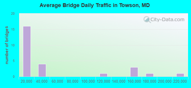
- 1,122,499Total average daily traffic
- 22,750Total average daily truck traffic
- National Bridge Inventory (NBI) Registered Bridges for Towson
- No street view available for this location
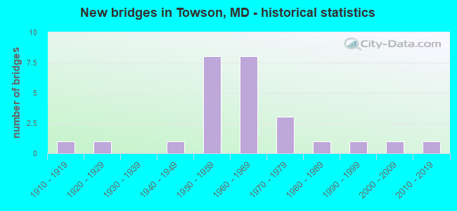
- New bridges - historical statistics
- 11910-1919
- 11920-1929
- 11940-1949
- 81950-1959
- 81960-1969
- 31970-1979
- 11980-1989
- 11990-1999
- 12000-2009
- 12010-2019
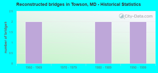
- Reconstructed bridges - Historical Statistics
- 21960-1969
- 01970-1979
- 21980-1989
- 21990-1999
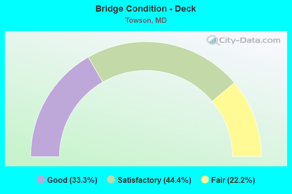
- Bridge Condition - Deck
- 33.3%Good
- 44.4%Satisfactory
- 22.2%Fair
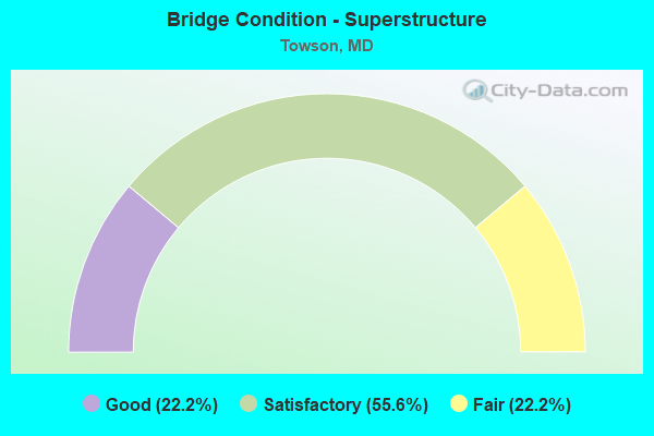
- Bridge Condition - Superstructure
- 22.2%Good
- 55.6%Satisfactory
- 22.2%Fair
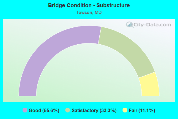
- Bridge Condition - Substructure
- 55.6%Good
- 33.3%Satisfactory
- 11.1%Fair
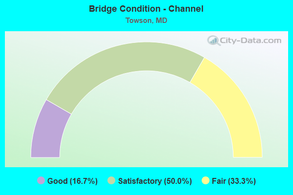
- Bridge Condition - Channel
- 16.7%Good
- 50.0%Satisfactory
- 33.3%Fair
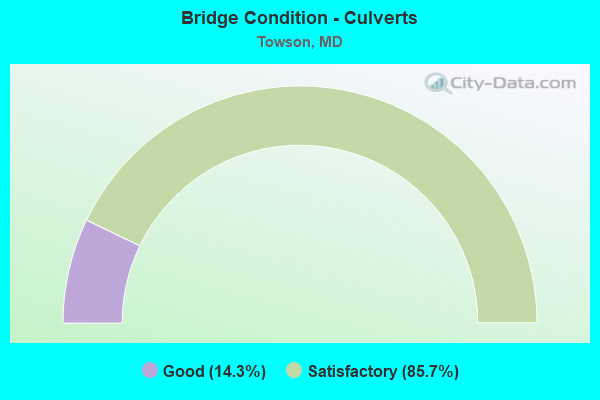
- Bridge Condition - Culverts
- 14.3%Good
- 85.7%Satisfactory
Find on map >> Show street view
Structure Number: 10000003015901, Location: 0.2 MILE NORTH OF IS 83 (Lat: 39.418825, Lng: -76.636336), Route carried "on" structure: Interstate 695, Year Built: 1955, Year Reconstructed: 1971, Status: Open, Structure Length: 6.52m (21.39ft), Average Daily Traffic: 205,485 (year 2019), Truck Traffic: 8%, Average Future Daily Traffic: 217,303 (year 2039), Design Load: HS 20, Features Intersected: MTA LIGHT RAIL
Minimum Vertical Clearance: 30+ m (98+ ft), Kilometerpoint: 30.668, Lanes on structure: 8, Base Highway Network: Yes, Owner: State Highway Agency, Approaching Roadway Width: 43.9m (144.0ft), Skew: 33 degrees, Material/Design: Steel, Design/Construction: Stringer/Multi-beam, Number Of Spans In Main Unit: 3, Length of Maximum Span: 27.1m (88.9ft), Curb-To-Curb Width: 53.3m (174.9ft), Out-to-Out Width: 54.3m (178.1ft)
Condition: Deck: Good, Superstructure: Fair, Substructure: Satisfactory, Operating Rating: 72.1 metric tons, Method Used To Determine Operating Rating: Load Factor (LF), Inventory Rating: 43.1 metric tons, Method Used To Determine Inventory Rating: Load Factor (LF), Structural Evaluation: Somewhat better than minimum adequacy, Deck Geometry: Superior to present desirable criteria, Underclear: Somewhat better than minimum adequacy, Approach Roadway Alignment: Equal to present desirable criteria, Length Of Structure Improvement: 6.52m (21.39ft), Designated Inspection Frequency: Every 24 months, Inspection Date: January 2021, Bridge Improvement Cost: $2,286,000, Roadway Improvement Cost: $229,000, Total Project Cost: $2,515,000, Deck Structure Type: Concrete Cast-file-Place, Wearing Surface/Protective System: Wearing Surface: Monolithic Concrete, Deck Protection: Epoxy Coated Reinforcing
Find on map >> Show street view
Structure Number: 200000B-006403, Location: 50 FT W BELLONA AVE (Lat: 39.409181, Lng: -76.645344), Route carried "on" structure: County highway 1400, Year Built: 1986, Status: Open, Structure Length: 1.46m (4.79ft), Average Daily Traffic: 20,511 (year 2021), Truck Traffic: 5%, Average Future Daily Traffic: 33,610 (year 2041), Design Load: HS 20, Features Intersected: MTA LIGHT RAIL, Facility Carried by Structure: JOPPA ROAD
Minimum Vertical Clearance: 30+ m (98+ ft), Kilometerpoint: 15.286, Lanes on structure: 2, Owner: County Highway Agency, Approaching Roadway Width: 9.1m (29.9ft), Material/Design: Steel, Design/Construction: Culvert, Length of Maximum Span: 7.3m (24.0ft), Curb or Sidewalk Widths: Left: 1.8m (5.9ft), Right: 0.0m
Condition: Culverts: Satisfactory, Operating Rating: 80.3 metric tons, Method Used To Determine Operating Rating: Load Factor (LF), Inventory Rating: 48.1 metric tons, Method Used To Determine Inventory Rating: Load Factor (LF), Structural Evaluation: Equal to present minimum criteria, Underclear: Meets minimum limits, Approach Roadway Alignment: Equal to present minimum criteria, Designated Inspection Frequency: Every 24 months, Inspection Date: October 2021
Find on map >> Show street view
Structure Number: 200000B-008301, Location: 100 FEET W OF BELLONA AVE (Lat: 39.398056, Lng: -76.645194), Route carried "on" structure: County highway 1474, Year Built: 1960, Year Reconstructed: 1988, Status: Open, Structure Length: 2.35m (7.71ft), Average Daily Traffic: 9,190 (year 2022), Truck Traffic: 5%, Average Future Daily Traffic: 13,813 (year 2042), Design Load: H 15, Features Intersected: MTA LIGHT RAIL, Facility Carried by Structure: RUXTON ROAD
Minimum Vertical Clearance: 30+ m (98+ ft), Kilometerpoint: 0.032, Lanes on structure: 2, Owner: County Highway Agency, Approaching Roadway Width: 7.9m (25.9ft), Material/Design: Steel, Design/Construction: Stringer/Multi-beam, Number Of Spans In Main Unit: 1, Number Of Approach Spans: 1, Length of Maximum Span: 16.8m (55.1ft), Curb or Sidewalk Widths: Left: 1.3m (4.3ft), Right: 1.3m (4.3ft), Curb-To-Curb Width: 7.9m (25.9ft), Out-to-Out Width: 11.1m (36.4ft)
Condition: Deck: Good, Superstructure: Satisfactory, Substructure: Fair, Operating Rating: 37.2 metric tons, Method Used To Determine Operating Rating: Load Factor (LF), Inventory Rating: 22.2 metric tons, Method Used To Determine Inventory Rating: Load Factor (LF), Structural Evaluation: Somewhat better than minimum adequacy, Deck Geometry: High priority of replacement, Underclear: High priority of corrective action, Approach Roadway Alignment: Equal to present minimum criteria, Designated Inspection Frequency: Every 24 months, Inspection Date: Febuary 2022, Deck Structure Type: Concrete Cast-file-Place, Wearing Surface/Protective System: Wearing Surface: Monolithic Concrete
Find on map >> Show street view
Structure Number: 200000B-008501, Location: 0.4 MI N OF JOPPA ROAD (Lat: 39.414869, Lng: -76.646086), Route carried "on" structure: County highway 1137, Year Built: 1959, Status: Open, Structure Length: 2.29m (7.51ft), Average Daily Traffic: 300 (year 2021), Truck Traffic: 5%, Average Future Daily Traffic: 800 (year 2041), Design Load: HS 20, Features Intersected: ROLAND RUN, Facility Carried by Structure: ESSEX FARM ROAD
Minimum Vertical Clearance: 30+ m (98+ ft), Kilometerpoint: 0.225, Lanes on structure: 2, Owner: County Highway Agency, Approaching Roadway Width: 9.1m (29.9ft), Skew: 3 degrees, Material/Design: Prestressed concrete, Design/Construction: Slab, Number Of Spans In Main Unit: 2, Length of Maximum Span: 11.0m (36.1ft), Curb or Sidewalk Widths: Left: 2.7m (8.9ft), Right: 2.7m (8.9ft), Curb-To-Curb Width: 9.1m (29.9ft), Out-to-Out Width: 15.2m (49.9ft)
Condition: Deck: Satisfactory, Superstructure: Satisfactory, Substructure: Satisfactory, Channel: Satisfactory, Operating Rating: 86.2 metric tons, Method Used To Determine Operating Rating: Load Factor (LF), Inventory Rating: 51.7 metric tons, Method Used To Determine Inventory Rating: Load Factor (LF), Structural Evaluation: Equal to present minimum criteria, Deck Geometry: Equal to present minimum criteria, Waterway Adequacy: Better than present minimum criteria, Approach Roadway Alignment: Equal to present minimum criteria, Designated Inspection Frequency: Every 24 months, Inspection Date: November 2021, Wearing Surface/Protective System: Wearing Surface: Bituminous
Find on map >> Show street view
Structure Number: 200000B-008701, Location: 0.2 MI W OF BELLONA AVE (Lat: 39.409283, Lng: -76.648422), Route carried "on" structure: County highway 1400, Year Built: 1970, Status: Posted for load, Structure Length: 1.95m (6.40ft), Average Daily Traffic: 14,437 (year 2021), Truck Traffic: 5%, Average Future Daily Traffic: 17,970 (year 2041), Design Load: HS 20, Features Intersected: ROLAND RUN, Facility Carried by Structure: JOPPA RD
Minimum Vertical Clearance: 30+ m (98+ ft), Kilometerpoint: 15.559, Lanes on structure: 3, Owner: County Highway Agency, Approaching Roadway Width: 12.2m (40.0ft), Material/Design: Concrete, Design/Construction: Slab, Number Of Spans In Main Unit: 2, Length of Maximum Span: 9.4m (30.8ft), Curb or Sidewalk Widths: Left: 1.2m (3.9ft), Right: 1.2m (3.9ft), Curb-To-Curb Width: 12.2m (40.0ft), Out-to-Out Width: 15.2m (49.9ft)
Condition: Deck: Fair, Superstructure: Fair, Substructure: Satisfactory, Channel: Fair, Operating Rating: 52.6 metric tons, Method Used To Determine Operating Rating: Load Factor (LF), Inventory Rating: 31.7 metric tons, Method Used To Determine Inventory Rating: Load Factor (LF), Structural Evaluation: Somewhat better than minimum adequacy, Deck Geometry: Meets minimum limits, Waterway Adequacy: Better than present minimum criteria, Approach Roadway Alignment: Equal to present desirable criteria, Bridge Posting: Required (Relationship of Operating Rating to Maximum Legal Load: 0.1 - 9.9% below), Designated Inspection Frequency: Every 24 months, Inspection Date: December 2021, Deck Structure Type: Concrete Cast-file-Place, Wearing Surface/Protective System: Wearing Surface: Bituminous
Find on map >> Show street view
Structure Number: 200000B-010801, Location: 300 FT W OF RUXWAY RD (Lat: 39.404994, Lng: -76.647897), Route carried "on" structure: County highway 1481, Year Built: 1942, Year Reconstructed: 2003, Status: Open, Structure Length: 0.98m (3.22ft), Average Daily Traffic: 832 (year 2021), Truck Traffic: 5%, Average Future Daily Traffic: 1,353 (year 2041), Design Load: HS 20, Features Intersected: ROLAND RUN, Facility Carried by Structure: ROLAND AVENUE
Minimum Vertical Clearance: 30+ m (98+ ft), Kilometerpoint: 0.354, Lanes on structure: 2, Owner: County Highway Agency, Approaching Roadway Width: 6.7m (22.0ft), Material/Design: Steel, Design/Construction: Stringer/Multi-beam, Number Of Spans In Main Unit: 1, Length of Maximum Span: 8.8m (28.9ft), Curb or Sidewalk Widths: Left: 1.5m (4.9ft), Right: 1.5m (4.9ft), Curb-To-Curb Width: 7.3m (24.0ft), Out-to-Out Width: 10.4m (34.1ft)
Condition: Deck: Good, Superstructure: Good, Substructure: Good, Channel: Satisfactory, Structural Evaluation: Better than present minimum criteria, Deck Geometry: Meets minimum limits, Waterway Adequacy: Equal to present minimum criteria, Approach Roadway Alignment: Equal to present desirable criteria, Designated Inspection Frequency: Every 24 months, Inspection Date: August 2021, Deck Structure Type: Concrete Cast-file-Place, Wearing Surface/Protective System: Wearing Surface: Monolithic Concrete, Deck Protection: Epoxy Coated Reinforcing
Find on map >> Show street view
Structure Number: 200000B-012701, Location: 0.1 MI W CHARLES ST (Lat: 39.393658, Lng: -76.629867), Route carried "on" structure: County highway 1421, Year Built: 1910, Year Reconstructed: 1974, Status: Open, Structure Length: 0.82m (2.69ft), Average Daily Traffic: 2,030 (year 2015), Truck Traffic: 5%, Average Future Daily Traffic: 3,000 (year 2035), Design Load: HS 20, Features Intersected: TOWSON RUN, Facility Carried by Structure: MALVERN AVENUE
Minimum Vertical Clearance: 30+ m (98+ ft), Kilometerpoint: 0.145, Lanes on structure: 2, Owner: County Highway Agency, Approaching Roadway Width: 6.7m (22.0ft), Skew: 1 degrees, Material/Design: Concrete, Design/Construction: Slab, Number Of Spans In Main Unit: 1, Length of Maximum Span: 7.0m (23.0ft), Curb or Sidewalk Widths: Left: 0.4m (1.3ft), Right: 0.4m (1.3ft), Curb-To-Curb Width: 7.3m (24.0ft), Out-to-Out Width: 8.1m (26.6ft)
Condition: Deck: Satisfactory, Superstructure: Satisfactory, Substructure: Good, Channel: Satisfactory, Operating Rating: 56.2 metric tons, Method Used To Determine Operating Rating: Load Factor (LF), Inventory Rating: 33.6 metric tons, Method Used To Determine Inventory Rating: Load Factor (LF), Structural Evaluation: Equal to present minimum criteria, Deck Geometry: High priority of replacement, Waterway Adequacy: Better than present minimum criteria, Approach Roadway Alignment: Equal to present minimum criteria, Designated Inspection Frequency: Every 24 months, Inspection Date: August 2021, Deck Structure Type: Concrete Cast-file-Place, Wearing Surface/Protective System: Wearing Surface: Monolithic Concrete
Find on map >> Show street view
Structure Number: 200000B-013101, Location: E OF DULANEY VALLEY RD (Lat: 39.402056, Lng: -76.600836), Route carried "on" structure: County highway 1400, Year Built: 1951, Year Reconstructed: 1990, Status: Posted for load, Structure Length: 8.60m (28.22ft), Average Daily Traffic: 26,498 (year 2021), Truck Traffic: 5%, Average Future Daily Traffic: 39,375 (year 2041), Design Load: H 20, Features Intersected: FORMER HUTZLER'S DEPARTM, Facility Carried by Structure: JOPPA ROAD
Minimum Vertical Clearance: 30+ m (98+ ft), Kilometerpoint: 11.231, Lanes on structure: 5, Owner: County Highway Agency, Approaching Roadway Width: 16.8m (55.1ft), Skew: 1 degrees, Material/Design: Concrete continuous, Design/Construction: Slab, Number Of Spans In Main Unit: 9, Length of Maximum Span: 10.1m (33.1ft), Curb or Sidewalk Widths: Left: 3.0m (9.8ft), Right: 3.4m (11.2ft), Curb-To-Curb Width: 16.8m (55.1ft), Out-to-Out Width: 23.5m (77.1ft)
Condition: Deck: Satisfactory, Superstructure: Satisfactory, Substructure: Good, Operating Rating: 29.9 metric tons, Method Used To Determine Operating Rating: Load Factor (LF), Inventory Rating: 17.7 metric tons, Method Used To Determine Inventory Rating: Load Factor (LF), Structural Evaluation: Meets minimum limits, Deck Geometry: High priority of replacement, Approach Roadway Alignment: Better than present minimum criteria, Bridge Posting: Required (Relationship of Operating Rating to Maximum Legal Load: 20.0 - 29.9% below), Designated Inspection Frequency: Every 12 months, Inspection Date: October 2021, Deck Structure Type: Concrete Cast-file-Place, Wearing Surface/Protective System: Wearing Surface: Bituminous
Find on map >> Show street view
Structure Number: 200000B-020701, Location: 0.17 MI W OF MD 139 (Lat: 39.402903, Lng: -76.633772), Route carried "on" structure: County highway 1409, Year Built: 1920, Year Reconstructed: 1989, Status: Open, Structure Length: 0.76m (2.49ft), Average Daily Traffic: 1,194 (year 2019), Truck Traffic: 5%, Average Future Daily Traffic: 1,774 (year 2039), Design Load: HS 20, Features Intersected: ROLAND RUN BRANCH, Facility Carried by Structure: BOYCE AVENUE
Minimum Vertical Clearance: 30+ m (98+ ft), Kilometerpoint: 1.094, Lanes on structure: 2, Owner: County Highway Agency, Approaching Roadway Width: 6.7m (22.0ft), Skew: 1 degrees, Material/Design: Prestressed concrete, Design/Construction: Box Beam or Girders - Multiple, Number Of Spans In Main Unit: 1, Length of Maximum Span: 6.7m (22.0ft), Curb-To-Curb Width: 6.7m (22.0ft), Out-to-Out Width: 7.5m (24.6ft)
Condition: Deck: Satisfactory, Superstructure: Satisfactory, Substructure: Good, Channel: Good, Operating Rating: 71.7 metric tons, Method Used To Determine Operating Rating: Load Factor (LF), Inventory Rating: 42.6 metric tons, Method Used To Determine Inventory Rating: Load Factor (LF), Structural Evaluation: Equal to present minimum criteria, Deck Geometry: High priority of corrective action, Waterway Adequacy: Equal to present minimum criteria, Approach Roadway Alignment: Equal to present desirable criteria, Designated Inspection Frequency: Every 24 months, Inspection Date: October 2021, Deck Structure Type: Concrete Precast Panels, Wearing Surface/Protective System: Wearing Surface: Monolithic Concrete
Find on map >> Show street view
Structure Number: 200000B-025301, Location: 2.77 MI S OF RUXTON RD (Lat: 4.542761, Lng: -8.073608), Route carried "on" structure: County highway 1475, Year Built: 1992, Status: Open, Structure Length: 3.20m (10.50ft), Average Daily Traffic: 100 (year 2019), Truck Traffic: 5%, Average Future Daily Traffic: 200 (year 2039), Design Load: HS 20, Features Intersected: ROLAND RUN, Facility Carried by Structure: L'HIRONDELLE CLUB
Minimum Vertical Clearance: 30+ m (98+ ft), Kilometerpoint: 0.000, Lanes on structure: 1, Owner: County Highway Agency, Approaching Roadway Width: 4.9m (16.1ft), Material/Design: Steel, Design/Construction: Truss - Thru, Number Of Spans In Main Unit: 1, Length of Maximum Span: 30.8m (101.0ft), Curb-To-Curb Width: 4.1m (13.5ft), Out-to-Out Width: 4.8m (15.7ft)
Condition: Deck: Fair, Superstructure: Good, Substructure: Good, Channel: Satisfactory, Operating Rating: 48.1 metric tons, Method Used To Determine Operating Rating: Load Factor (LF), Inventory Rating: 28.6 metric tons, Method Used To Determine Inventory Rating: Load Factor (LF), Structural Evaluation: Better than present minimum criteria, Deck Geometry: Somewhat better than minimum adequacy, Waterway Adequacy: Better than present minimum criteria, Approach Roadway Alignment: Equal to present minimum criteria, Designated Inspection Frequency: Every 24 months, Critical Feature Inspection Frequency: Every 24 months, Inspection Date: September 2021, Critical Feature Inspection Date: September 2021, Deck Structure Type: Steel plate, Wearing Surface/Protective System: Wearing Surface: Other
Find on map >> Show street view
Structure Number: 200000B-033502, Location: 0.15 MI E OF MD 139 (Lat: 39.396297, Lng: -76.624392), Route carried "on" structure: County highway 1354, Year Built: 1964, Status: Open, Structure Length: 1.03m (3.38ft), Average Daily Traffic: 31,694 (year 2019), Truck Traffic: 5%, Average Future Daily Traffic: 47,096 (year 2039), Design Load: HS 20, Features Intersected: TOWSON RUN, Facility Carried by Structure: TOWSONTOWN BLVD
Minimum Vertical Clearance: 30+ m (98+ ft), Kilometerpoint: 1.915, Lanes on structure: 5, Owner: County Highway Agency, Approaching Roadway Width: 16.5m (54.1ft), Skew: 4 degrees, Material/Design: Concrete, Design/Construction: Culvert, Length of Maximum Span: 4.9m (16.1ft), Curb or Sidewalk Widths: Left: 0.0m, Right: 1.5m (4.9ft)
Condition: Channel: Satisfactory, Culverts: Satisfactory, Operating Rating: 54.9 metric tons, Method Used To Determine Operating Rating: Load Factor (LF), Inventory Rating: 32.7 metric tons, Method Used To Determine Inventory Rating: Load Factor (LF), Structural Evaluation: Equal to present minimum criteria, Waterway Adequacy: Equal to present minimum criteria, Approach Roadway Alignment: Equal to present desirable criteria, Designated Inspection Frequency: Every 24 months, Inspection Date: August 2021
Find on map >> Show street view
Structure Number: 200000B-034902, Location: 0.04 M S OF TWSNTOWN BLVD (Lat: 39.395297, Lng: -76.615200), Route carried "on" structure: County highway 1353, Year Built: 1964, Status: Open, Structure Length: 0.73m (2.40ft), Average Daily Traffic: 2,300 (year 2013), Truck Traffic: 5%, Average Future Daily Traffic: 6,376 (year 2039), Design Load: HS 20, Features Intersected: TOWSON RUN, Facility Carried by Structure: OSLER DRIVE
Minimum Vertical Clearance: 30+ m (98+ ft), Kilometerpoint: 1.352, Lanes on structure: 5, Owner: County Highway Agency, Approaching Roadway Width: 14.6m (47.9ft), Material/Design: Concrete, Design/Construction: Culvert, Length of Maximum Span: 3.7m (12.1ft), Curb or Sidewalk Widths: Left: 0.0m, Right: 1.2m (3.9ft)
Condition: Channel: Fair, Culverts: Good, Operating Rating: 32.7 metric tons, Method Used To Determine Operating Rating: Field evaluation and documented engineering judgment, Inventory Rating: 32.7 metric tons, Method Used To Determine Inventory Rating: Field evaluation and documented engineering judgment, Structural Evaluation: Better than present minimum criteria, Waterway Adequacy: Equal to present desirable criteria, Approach Roadway Alignment: Equal to present desirable criteria, Designated Inspection Frequency: Every 24 months, Inspection Date: July 2021
Find on map >> Show street view
Structure Number: 200000B-035402, Location: 0.25 MI W OF MD 542 (Lat: 39.373992, Lng: -76.584539), Route carried "on" structure: County highway 1300, Year Built: 1965, Status: Open, Structure Length: 1.28m (4.20ft), Average Daily Traffic: 2,820 (year 2021), Truck Traffic: 5%, Average Future Daily Traffic: 3,441 (year 2021), Design Load: HS 20, Features Intersected: HERRING RUN, Facility Carried by Structure: REGESTER AVENUE
Minimum Vertical Clearance: 30+ m (98+ ft), Kilometerpoint: 2.993, Lanes on structure: 2, Owner: County Highway Agency, Approaching Roadway Width: 9.1m (29.9ft), Skew: 3 degrees, Material/Design: Concrete, Design/Construction: Culvert, Number Of Spans In Main Unit: 2, Length of Maximum Span: 6.1m (20.0ft), Curb or Sidewalk Widths: Left: 3.0m (9.8ft), Right: 3.0m (9.8ft)
Condition: Channel: Good, Culverts: Satisfactory, Operating Rating: 32.7 metric tons, Method Used To Determine Operating Rating: Field evaluation and documented engineering judgment, Inventory Rating: 32.7 metric tons, Method Used To Determine Inventory Rating: Field evaluation and documented engineering judgment, Structural Evaluation: Equal to present minimum criteria, Waterway Adequacy: Equal to present desirable criteria, Approach Roadway Alignment: Equal to present desirable criteria, Designated Inspection Frequency: Every 24 months, Inspection Date: December 2021, Wearing Surface/Protective System: Wearing Surface: Bituminous
Find on map >> Show street view
Structure Number: 200000B-037402, Location: 0.42 MI E OF MD 134 (Lat: 39.401631, Lng: -76.648481), Route carried "on" structure: County highway 1474, Year Built: 1959, Status: Open, Structure Length: 2.29m (7.51ft), Average Daily Traffic: 7,575 (year 2021), Truck Traffic: 5%, Average Future Daily Traffic: 13,200 (year 2041), Features Intersected: ROLAND RUN, Facility Carried by Structure: RUXTON ROAD
Minimum Vertical Clearance: 30+ m (98+ ft), Kilometerpoint: 0.676, Lanes on structure: 2, Owner: County Highway Agency, Approaching Roadway Width: 9.1m (29.9ft), Material/Design: Concrete, Design/Construction: Culvert, Length of Maximum Span: 5.2m (17.1ft), Curb or Sidewalk Widths: Left: 1.0m (3.3ft), Right: 1.0m (3.3ft), Curb-To-Curb Width: 9.1m (29.9ft), Out-to-Out Width: 11.7m (38.4ft)
Condition: Channel: Fair, Culverts: Satisfactory, Inventory Rating: 64.9 metric tons, Method Used To Determine Inventory Rating: Load Factor (LF), Structural Evaluation: Equal to present minimum criteria, Deck Geometry: High priority of corrective action, Waterway Adequacy: Equal to present minimum criteria, Approach Roadway Alignment: Equal to present minimum criteria, Designated Inspection Frequency: Every 24 months, Inspection Date: December 2021, Wearing Surface/Protective System: Wearing Surface: Bituminous
Find on map >> Show street view
Structure Number: 200000B-039903, Location: 0.01 MI W OF GOUCHER BLVD (Lat: 39.384700, Lng: -76.580247), Route carried "on" structure: County highway 3376, Year Built: 1968, Status: Open, Structure Length: 0.87m (2.85ft), Average Daily Traffic: 6,700 (year 2013), Truck Traffic: 5%, Average Future Daily Traffic: 12,100 (year 2035), Design Load: HS 20, Features Intersected: HERRING RUN, Facility Carried by Structure: COLBURY ROAD
Minimum Vertical Clearance: 30+ m (98+ ft), Kilometerpoint: 0.032, Lanes on structure: 4, Base Highway Network: Yes, Owner: County Highway Agency, Approaching Roadway Width: 17.1m (56.1ft), Skew: 20 degrees, Material/Design: Concrete, Design/Construction: Culvert, Length of Maximum Span: 3.4m (11.2ft), Curb or Sidewalk Widths: Left: 1.2m (3.9ft), Right: 1.2m (3.9ft)
Condition: Channel: Satisfactory, Culverts: Satisfactory, Inventory Rating: 59.9 metric tons, Method Used To Determine Inventory Rating: Load Factor (LF), Structural Evaluation: Equal to present minimum criteria, Waterway Adequacy: Better than present minimum criteria, Approach Roadway Alignment: Equal to present desirable criteria, Designated Inspection Frequency: Every 24 months, Inspection Date: July 2021
Find on map >> Show street view
Structure Number: 200000B-054003, Location: 0.1 MI S. OF GOUCHER BLVD (Lat: 39.388250, Lng: -76.581111), Route carried "on" structure: Other road 6751, Year Built: 1975, Status: Open, Structure Length: 0.75m (2.46ft), Average Daily Traffic: 454 (year 2020), Truck Traffic: 2%, Average Future Daily Traffic: 1,662 (year 2042), Design Load: HS 20, Features Intersected: BRANCH OF HERRING RUN, Facility Carried by Structure: JACOBO LANE
Minimum Vertical Clearance: 30+ m (98+ ft), Kilometerpoint: 0.000, Lanes on structure: 2, Owner: County Highway Agency, Approaching Roadway Width: 7.3m (24.0ft), Material/Design: Steel, Design/Construction: Culvert, Length of Maximum Span: 2.4m (7.9ft)
Condition: Channel: Fair, Culverts: Satisfactory, Structural Evaluation: Equal to present minimum criteria, Waterway Adequacy: Equal to present desirable criteria, Approach Roadway Alignment: Better than present minimum criteria, Designated Inspection Frequency: Every 24 months, Inspection Date: January 2020
Find on map >> Show street view
Structure Number: 100000030051011, Location: 0.2 MILE SOUTH OF MD 133 (Lat: 39.396986, Lng: -76.665778), Route carried "under" structure: State highway 25, Year Built: 1962, Structure Length: 0. m, Average Daily Traffic: 10,911 (year 2009), Features Intersected: MD 25, JONES FALLS, Facility Carried by Structure: IS 83 NBR
Minimum Vertical Clearance: 5.49m (18.01ft), Kilometerpoint: 3.347, Lanes on structure: 3, Lanes under structure: 2, Material/Design: Steel, Design/Construction: Stringer/Multi-beam, Length of Maximum Span: 21.6m (70.9ft)
Find on map >> Show street view
Structure Number: 100000030051012, Location: 0.2 MILE SOUTH OF MD 133 (Lat: 39.397869, Lng: -76.665436), Route carried "under" structure: State highway 25, Year Built: 1962, Structure Length: 0. m, Average Daily Traffic: 10,911 (year 2009), Features Intersected: MD 25, JONES FALLS, Facility Carried by Structure: IS 83 SBR
Minimum Vertical Clearance: 4.57m (14.99ft), Kilometerpoint: 3.347, Lanes on structure: 3, Lanes under structure: 2, Material/Design: Steel, Design/Construction: Stringer/Multi-beam, Length of Maximum Span: 21.6m (70.9ft)
Find on map >> Show street view
Structure Number: 10000003007901, Location: 0.38 MILE SOUTH OF IS 695 (Lat: 39.411411, Lng: -76.630222), Route carried "under" structure: State highway 139, Year Built: 1958, Structure Length: 0. m, Average Daily Traffic: 35,831 (year 2009), Features Intersected: MD 139, Facility Carried by Structure: JOPPA ROAD
Minimum Vertical Clearance: 6.10m (20.01ft), Kilometerpoint: 4.988, Lanes on structure: 2, Lanes under structure: 4, Material/Design: Steel continuous, Design/Construction: Girder and Floorbeam System, Length of Maximum Span: 37.5m (123.0ft)
Find on map >> Show street view
Structure Number: 10000003008201, Location: 0.26 MI W OF MD 25 (Lat: 39.400894, Lng: -76.662367), Route carried "under" structure: Interstate 83, Year Built: 1961, Structure Length: 0. m, Average Daily Traffic: 100,651 (year 2009), Features Intersected: IS 83, Facility Carried by Structure: RUXTON ROAD
Minimum Vertical Clearance: 5.18m (16.99ft), Kilometerpoint: 3.652, Lanes on structure: 2, Lanes under structure: 6, Material/Design: Steel, Design/Construction: Stringer/Multi-beam, Length of Maximum Span: 23.5m (77.1ft)
Find on map >> Show street view
Structure Number: 10000003015701, Location: 1.09 MI S OF MD 139 (Lat: 39.420589, Lng: -76.648817), Route carried "under" structure: County highway 1117, Year Built: 1954, Structure Length: 0. m, Average Daily Traffic: 3,423 (year 2012), Features Intersected: THORNTON ROAD, Facility Carried by Structure: IS 83/IS 695
Minimum Vertical Clearance: 4.88m (16.01ft), Kilometerpoint: 0.451, Lanes on structure: 8, Lanes under structure: 2, Material/Design: Steel, Design/Construction: Stringer/Multi-beam, Length of Maximum Span: 14.9m (48.9ft)
Find on map >> Show street view
Structure Number: 10000003015801, Location: 0.64 MI S OF MD 139 (Lat: 39.419858, Lng: -76.640522), Route carried "under" structure: Interstate 83, Year Built: 1955, Structure Length: 0. m, Average Daily Traffic: 142,367 (year 2009), Features Intersected: IS 83 NBR, Facility Carried by Structure: IS 695
Minimum Vertical Clearance: 5.18m (16.99ft), Kilometerpoint: 7.337, Lanes on structure: 6, Lanes under structure: 2, Material/Design: Steel, Design/Construction: Stringer/Multi-beam, Length of Maximum Span: 15.5m (50.9ft)
Find on map >> Show street view
Structure Number: 10000003016001, Location: 0.62 MILE NORTH OF IS 83 (Lat: 39.416414, Lng: -76.629425), Route carried "under" structure: Interstate 695, Year Built: 2010, Structure Length: 0. m, Average Daily Traffic: 174,400 (year 2010), Features Intersected: IS 695, Facility Carried by Structure: MD 139
Minimum Vertical Clearance: 5.18m (16.99ft), Kilometerpoint: 31.343, Lanes on structure: 7, Lanes under structure: 8, Material/Design: Steel, Design/Construction: Stringer/Multi-beam, Length of Maximum Span: 23.8m (78.1ft)
Find on map >> Show street view
Structure Number: 10000003016101, Location: 0.63 MILE SOUTH OF MD 146 (Lat: 39.413453, Lng: -76.611728), Route carried "under" structure: Interstate 695, Year Built: 2005, Structure Length: 0. m, Average Daily Traffic: 149,382 (year 2009), Features Intersected: IS 695, Facility Carried by Structure: MD 45
Minimum Vertical Clearance: 5.49m (18.01ft), Kilometerpoint: 32.985, Lanes on structure: 6, Lanes under structure: 6, Material/Design: Steel continuous, Design/Construction: Stringer/Multi-beam, Length of Maximum Span: 45.7m (149.9ft)
Find on map >> Show street view
Structure Number: 10000003016201, Location: 0.63 MILE NORTH OF MD 45 (Lat: 39.412631, Lng: -76.600314), Route carried "under" structure: Interstate 695, Year Built: 1957, Structure Length: 0. m, Average Daily Traffic: 153,692 (year 2009), Features Intersected: IS 695, Facility Carried by Structure: MD 146
Minimum Vertical Clearance: 5.49m (18.01ft), Kilometerpoint: 33.998, Lanes on structure: 6, Lanes under structure: 8, Material/Design: Steel continuous, Design/Construction: Stringer/Multi-beam, Length of Maximum Span: 21.3m (69.9ft)
Find on map >> Show street view
Structure Number: 10000003020401, Location: 0.40 MI S OF MD 139 (Lat: 39.418150, Lng: -76.633833), Route carried "under" structure: Interstate 83, Year Built: 1973, Structure Length: 0. m, Average Daily Traffic: 8,811 (year 2007), Features Intersected: IS 83 RAMP 'C', Facility Carried by Structure: IS 695 RAMP 'B'
Minimum Vertical Clearance: 4.88m (16.01ft), Kilometerpoint: 7.337, Lanes on structure: 1, Lanes under structure: 2, Material/Design: Steel continuous, Design/Construction: Stringer/Multi-beam, Length of Maximum Span: 50.0m (164.0ft)