Bridge Statistics for Totowa, New Jersey (NJ)
Condition, Traffic, Stress, Structural Evaluation, Project Costs
- National Bridge Inventory (NBI) Statistics
- 24Number of bridges
- 358ft / 109mTotal length
- $31,038,000Total costs
- 1,287,543Total average daily traffic
- 71,919Total average daily truck traffic
- National Bridge Inventory (NBI) Registered Bridges for Totowa
- No street view available for this location
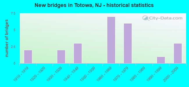
- New bridges - historical statistics
- 21910-1919
- 21930-1939
- 31940-1949
- 71960-1969
- 61970-1979
- 11990-1999
- 32000-2009

- Reconstructed bridges - Historical Statistics
- 11940-1949
- 01950-1959
- 01960-1969
- 11970-1979
- 01980-1989
- 21990-1999


- Bridge Condition - Deck
- 50.0%Good
- 33.3%Satisfactory
- 8.3%Fair
- 8.3%Poor

- Bridge Condition - Superstructure
- 7.1%Very good
- 42.9%Good
- 28.6%Satisfactory
- 14.3%Fair
- 7.1%Poor

- Bridge Condition - Substructure
- 42.9%Good
- 14.3%Satisfactory
- 42.9%Fair

- Bridge Condition - Channel
- 57.1%Good
- 28.6%Satisfactory
- 14.3%Fair

- Bridge Condition - Culverts
- 50.0%Good
- 50.0%Satisfactory
Find on map >> Show street view
Structure Number: 1600021, Location: 0.15 MI N OF CR639 (Lat: 40.891889, Lng: -74.218519), Route carried "on" structure: County highway 632, Year Built: 1997, Status: Open, Structure Length: 10.58m (34.71ft), Average Daily Traffic: 7,842 (year 2021), Truck Traffic: 4%, Average Future Daily Traffic: 9,569 (year 2041), Design Load: HS 20+Mod, Features Intersected: PASSAIC RIVER, Facility Carried by Structure: LACKAWANNA AVENUE
Minimum Vertical Clearance: 30+ m (98+ ft), Kilometerpoint: 2.559, Lanes on structure: 2, Owner: County Highway Agency, Approaching Roadway Width: 13.4m (44.0ft), Skew: 2 degrees, Material/Design: Steel continuous, Design/Construction: Stringer/Multi-beam, Number Of Spans In Main Unit: 3, Length of Maximum Span: 37.2m (122.0ft), Curb or Sidewalk Widths: Left: 1.8m (5.9ft), Right: 0.0m, Curb-To-Curb Width: 13.4m (44.0ft), Out-to-Out Width: 16.2m (53.1ft)
Condition: Deck: Good, Superstructure: Good, Substructure: Good, Channel: Good, Operating Rating: 60.8 metric tons, Method Used To Determine Operating Rating: Load Factor (LF), Inventory Rating: 36.3 metric tons, Method Used To Determine Inventory Rating: Load Factor (LF), Structural Evaluation: Better than present minimum criteria, Deck Geometry: Equal to present minimum criteria, Waterway Adequacy: Equal to present desirable criteria, Approach Roadway Alignment: Equal to present desirable criteria, Designated Inspection Frequency: Every 24 months, Inspection Date: April 2021, Deck Structure Type: Concrete Cast-file-Place, Wearing Surface/Protective System: Wearing Surface: Monolithic Concrete, Deck Protection: Epoxy Coated Reinforcing
Find on map >> Show street view
Structure Number: 160003, Location: CO LINE W OF PAT HAM TPK (Lat: 41.003581, Lng: -74.334839), Route carried "on" structure: County highway 511, Year Built: 1915, Year Reconstructed: 1948, Status: Open, Structure Length: 2.29m (7.51ft), Average Daily Traffic: 9,815 (year 2021), Truck Traffic: 4%, Average Future Daily Traffic: 13,220 (year 2041), Features Intersected: PEQUANNOCK RIVER
Minimum Vertical Clearance: 30+ m (98+ ft), Kilometerpoint: 29.596, Lanes on structure: 2, Owner: County Highway Agency, Approaching Roadway Width: 10.7m (35.1ft), Skew: 1 degrees, Material/Design: Concrete, Design/Construction: Arch - Deck, Number Of Spans In Main Unit: 1, Length of Maximum Span: 22.9m (75.1ft), Curb or Sidewalk Widths: Left: 1.5m (4.9ft), Right: 1.5m (4.9ft), Curb-To-Curb Width: 10.7m (35.1ft), Out-to-Out Width: 15.5m (50.9ft)
Condition: Superstructure: Fair, Substructure: Fair, Channel: Fair, Operating Rating: 42.6 metric tons, Method Used To Determine Operating Rating: Load Factor (LF), Inventory Rating: 25.4 metric tons, Method Used To Determine Inventory Rating: Load Factor (LF), Structural Evaluation: Somewhat better than minimum adequacy, Deck Geometry: Meets minimum limits, Waterway Adequacy: Superior to present desirable criteria, Approach Roadway Alignment: Equal to present desirable criteria, Length Of Structure Improvement: 2.19m (7.19ft), Designated Inspection Frequency: Every 24 months, Inspection Date: April 2021, Bridge Improvement Cost: $125,000, Total Project Cost: $125,000 ( Estimate for 2019)
Find on map >> Show street view
Structure Number: 1600039, Location: 0.5 E OF UNION BLVD/CR646 (Lat: 40.903911, Lng: -74.199861), Route carried "on" structure: County highway 644, Year Built: 2008, Status: Open, Structure Length: 10.76m (35.30ft), Average Daily Traffic: 6,210 (year 2021), Truck Traffic: 4%, Average Future Daily Traffic: 8,370 (year 2041), Design Load: HL 93, Features Intersected: PASSAIC RIVER, Facility Carried by Structure: HILLERY STREET
Minimum Vertical Clearance: 30+ m (98+ ft), Kilometerpoint: 0.000, Lanes on structure: 2, Owner: County Highway Agency, Approaching Roadway Width: 9.1m (29.9ft), Material/Design: Steel continuous, Design/Construction: Stringer/Multi-beam, Number Of Spans In Main Unit: 4, Length of Maximum Span: 26.8m (87.9ft), Curb or Sidewalk Widths: Left: 1.5m (4.9ft), Right: 1.5m (4.9ft), Curb-To-Curb Width: 9.1m (29.9ft), Out-to-Out Width: 10.0m (32.8ft)
Condition: Deck: Good, Superstructure: Very good, Substructure: Good, Channel: Good, Operating Rating: 81.6 metric tons, Method Used To Determine Operating Rating: Load and Resistance Factor (LRFR), Inventory Rating: 49.0 metric tons, Method Used To Determine Inventory Rating: Load and Resistance Factor (LRFR), Structural Evaluation: Better than present minimum criteria, Deck Geometry: Meets minimum limits, Waterway Adequacy: Equal to present minimum criteria, Approach Roadway Alignment: Equal to present minimum criteria, Designated Inspection Frequency: Every 24 months, Underwater Inspection Frequency: Every 48 months, Inspection Date: March 2021, Underwater Inspection Date: July 2019, Deck Structure Type: Concrete Cast-file-Place, Wearing Surface/Protective System: Deck Protection: Epoxy Coated Reinforcing
Find on map >> Show street view
Structure Number: 1600321, Location: NORTH OF MADISON ROAD (Lat: 40.909939, Lng: -74.241231), Route carried "on" structure: County highway 640, Year Built: 1976, Status: Open, Structure Length: 0.91m (2.99ft), Average Daily Traffic: 44,448 (year 2021), Truck Traffic: 4%, Average Future Daily Traffic: 54,235 (year 2041), Design Load: HS 20+Mod, Features Intersected: NAACHTPUNKT BROOK
Minimum Vertical Clearance: 30+ m (98+ ft), Kilometerpoint: 1.883, Lanes on structure: 4, Base Highway Network: Yes, Owner: County Highway Agency, Approaching Roadway Width: 14.9m (48.9ft), Skew: 3 degrees, Material/Design: Concrete, Design/Construction: Culvert, Number Of Spans In Main Unit: 2, Length of Maximum Span: 4.3m (14.1ft), Curb or Sidewalk Widths: Left: 1.8m (5.9ft), Right: 0.0m, Curb-To-Curb Width: 15.0m (49.2ft), Out-to-Out Width: 18.9m (62.0ft)
Condition: Channel: Satisfactory, Culverts: Good, Operating Rating: 47.2 metric tons, Method Used To Determine Operating Rating: Load Factor (LF), Inventory Rating: 28.1 metric tons, Method Used To Determine Inventory Rating: Load Factor (LF), Structural Evaluation: Better than present minimum criteria, Deck Geometry: High priority of replacement, Waterway Adequacy: Equal to present minimum criteria, Approach Roadway Alignment: Equal to present desirable criteria, Length Of Structure Improvement: 0.91m (2.99ft), Designated Inspection Frequency: Every 24 months, Inspection Date: April 2021, Bridge Improvement Cost: $20,000, Roadway Improvement Cost: $17,000, Total Project Cost: $47,000 ( Estimate for 2021)
Find on map >> Show street view
Structure Number: 1606156, Location: 0.68 MILES EAST OF NJ 23 (Lat: 40.894681, Lng: -74.236269), Route carried "on" structure: County highway 640, Year Built: 1948, Year Reconstructed: 2003, Status: Open, Structure Length: 4.91m (16.11ft), Average Daily Traffic: 27,681 (year 2021), Truck Traffic: 4%, Average Future Daily Traffic: 33,217 (year 2041), Design Load: HS 20+Mod, Features Intersected: US 46
Minimum Vertical Clearance: 30+ m (98+ ft), Kilometerpoint: 3.605, Lanes on structure: 4, Lanes under structure: 8, Owner: State Highway Agency, Approaching Roadway Width: 16.5m (54.1ft), Skew: 2 degrees, Material/Design: Steel, Design/Construction: Stringer/Multi-beam, Number Of Spans In Main Unit: 2, Length of Maximum Span: 23.8m (78.1ft), Curb or Sidewalk Widths: Left: 1.8m (5.9ft), Right: 1.8m (5.9ft), Curb-To-Curb Width: 16.5m (54.1ft), Out-to-Out Width: 20.7m (67.9ft)
Condition: Deck: Good, Superstructure: Good, Substructure: Good, Inventory Rating: 64.4 metric tons, Method Used To Determine Inventory Rating: Load Factor (LF), Structural Evaluation: Better than present minimum criteria, Deck Geometry: Meets minimum limits, Underclear: Better than present minimum criteria, Approach Roadway Alignment: Equal to present desirable criteria, Designated Inspection Frequency: Every 24 months, Inspection Date: April 2021, Deck Structure Type: Concrete Cast-file-Place, Wearing Surface/Protective System: Deck Protection: Epoxy Coated Reinforcing
Find on map >> Show street view
Structure Number: 1606157, Location: 1.2 MILES EAST OF NJ 23 (Lat: 40.893031, Lng: -74.225831), Route carried "on" structure: County highway 646, Year Built: 2006, Status: Open, Structure Length: 4.75m (15.58ft), Average Daily Traffic: 20,098 (year 2020), Truck Traffic: 4%, Average Future Daily Traffic: 24,118 (year 2040), Design Load: HL 93, Features Intersected: US 46
Minimum Vertical Clearance: 30+ m (98+ ft), Kilometerpoint: 1.593, Lanes on structure: 4, Lanes under structure: 7, Owner: State Highway Agency, Approaching Roadway Width: 20.7m (67.9ft), Skew: 1 degrees, Material/Design: Steel continuous, Design/Construction: Stringer/Multi-beam, Number Of Spans In Main Unit: 2, Length of Maximum Span: 24.1m (79.1ft), Curb or Sidewalk Widths: Left: 1.8m (5.9ft), Right: 1.8m (5.9ft), Curb-To-Curb Width: 20.7m (67.9ft), Out-to-Out Width: 24.7m (81.0ft)
Condition: Deck: Good, Superstructure: Good, Substructure: Good, Operating Rating: 84.6 metric tons, Method Used To Determine Operating Rating: Load and Resistance Factor Rating (LRFR) rating reported by rating factor(RF) method using HL-93 loadings, Inventory Rating: 65.1 metric tons, Method Used To Determine Inventory Rating: Load and Resistance Factor Rating (LRFR) rating reported by rating factor(RF) method using HL-93 loadings, Structural Evaluation: Better than present minimum criteria, Deck Geometry: Superior to present desirable criteria, Underclear: Equal to present minimum criteria, Approach Roadway Alignment: Equal to present desirable criteria, Designated Inspection Frequency: Every 24 months, Inspection Date: March 2020, Deck Structure Type: Concrete Cast-file-Place, Wearing Surface/Protective System: Wearing Surface: Monolithic Concrete, Deck Protection: Epoxy Coated Reinforcing
Find on map >> Show street view
Structure Number: 1606158, Location: .5 MI SOUTH OF I-80 (Lat: 40.890781, Lng: -74.220811), Route carried "on" structure: US 46, Year Built: 1939, Year Reconstructed: 1998, Status: Open, Structure Length: 14.57m (47.80ft), Average Daily Traffic: 144,450 (year 2020), Truck Traffic: 4%, Average Future Daily Traffic: 176,256 (year 2040), Design Load: HS 20, Features Intersected: PASSAIC RIV,RIVERVIEW DR
Minimum Vertical Clearance: 30+ m (98+ ft), Kilometerpoint: 93.245, Lanes on structure: 6, Lanes under structure: 2, Base Highway Network: Yes, Owner: State Highway Agency, Approaching Roadway Width: 29.6m (97.1ft), Skew: 30 degrees, Material/Design: Concrete, Design/Construction: Arch - Deck, Number Of Spans In Main Unit: 5, Length of Maximum Span: 29.3m (96.1ft), Curb or Sidewalk Widths: Left: 1.8m (5.9ft), Right: 0.0m, Curb-To-Curb Width: 29.8m (97.8ft), Out-to-Out Width: 33.4m (109.6ft)
Condition: Deck: Good, Superstructure: Satisfactory, Substructure: Good, Channel: Good, Operating Rating: 65.3 metric tons, Method Used To Determine Operating Rating: Load Factor (LF), Inventory Rating: 39.0 metric tons, Method Used To Determine Inventory Rating: Load Factor (LF), Structural Evaluation: Equal to present minimum criteria, Deck Geometry: Superior to present desirable criteria, Underclear: High priority of corrective action, Waterway Adequacy: Superior to present desirable criteria, Approach Roadway Alignment: Equal to present desirable criteria, Length Of Structure Improvement: 0.75m (2.46ft), Designated Inspection Frequency: Every 24 months, Inspection Date: April 2020, Roadway Improvement Cost: $1,270,000, Total Project Cost: $1,461,000 ( Estimate for 2020), Deck Structure Type: Concrete Cast-file-Place, Wearing Surface/Protective System: Wearing Surface: Bituminous, Membrane: Epoxy
Find on map >> Show street view
Structure Number: 160915, Location: 0.25 MI WEST OF RTE 23 (Lat: 40.895781, Lng: -74.257811), Route carried "on" structure: Interstate 80, Year Built: 1967, Status: Open, Structure Length: 2.26m (7.41ft), Average Daily Traffic: 108,485 (year 2020), Truck Traffic: 9%, Average Future Daily Traffic: 130,182 (year 2040), Design Load: HS 20, Features Intersected: SINGAC BROOK
Minimum Vertical Clearance: 30+ m (98+ ft), Kilometerpoint: 85.826, Lanes on structure: 9, Base Highway Network: Yes, Owner: State Highway Agency, Approaching Roadway Width: 44.8m (147.0ft), Skew: 33 degrees, Material/Design: Concrete, Design/Construction: Culvert, Number Of Spans In Main Unit: 3, Length of Maximum Span: 7.0m (23.0ft)
Condition: Channel: Satisfactory, Culverts: Satisfactory, Operating Rating: 60.8 metric tons, Method Used To Determine Operating Rating: Load Factor (LF), Inventory Rating: 36.3 metric tons, Method Used To Determine Inventory Rating: Load Factor (LF), Structural Evaluation: Equal to present minimum criteria, Waterway Adequacy: Equal to present desirable criteria, Approach Roadway Alignment: Equal to present desirable criteria, Designated Inspection Frequency: Every 24 months, Inspection Date: October 2020
Find on map >> Show street view
Structure Number: 1609155, Location: 0.78 MI EAST OF NJ RT 23 (Lat: 40.899300, Lng: -74.238131), Route carried "on" structure: Interstate 80, Year Built: 1967, Status: Open, Structure Length: 1.92m (6.30ft), Average Daily Traffic: 52,284 (year 2021), Truck Traffic: 9%, Average Future Daily Traffic: 63,796 (year 2041), Design Load: HS 20+Mod, Features Intersected: RIVERVIEW DRIVE (CR 640)
Minimum Vertical Clearance: 30+ m (98+ ft), Kilometerpoint: 87.548, Lanes on structure: 8, Lanes under structure: 4, Base Highway Network: Yes, Owner: State Highway Agency, Approaching Roadway Width: 42.1m (138.1ft), Skew: 30 degrees, Material/Design: Prestressed concrete, Design/Construction: Stringer/Multi-beam, Number Of Spans In Main Unit: 1, Length of Maximum Span: 18.0m (59.1ft), Curb or Sidewalk Widths: Left: 0.2m (0.7ft), Right: 0.2m (0.7ft), Curb-To-Curb Width: 42.1m (138.1ft), Out-to-Out Width: 44.2m (145.0ft)
Condition: Deck: Fair, Superstructure: Satisfactory, Substructure: Satisfactory, Operating Rating: 60.8 metric tons, Method Used To Determine Operating Rating: Load Factor (LF), Inventory Rating: 36.3 metric tons, Method Used To Determine Inventory Rating: Load Factor (LF), Structural Evaluation: Equal to present minimum criteria, Deck Geometry: Superior to present desirable criteria, Underclear: Meets minimum limits, Approach Roadway Alignment: Equal to present desirable criteria, Designated Inspection Frequency: Every 24 months, Inspection Date: March 2021, Deck Structure Type: Concrete Cast-file-Place, Wearing Surface/Protective System: Wearing Surface: Latex Concrete
Find on map >> Show street view
Structure Number: 1609156, Location: 0.92 MI EAST OF RT NJ 23 (Lat: 40.899450, Lng: -74.235481), Route carried "on" structure: Interstate 80, Year Built: 1970, Status: Open, Structure Length: 2.96m (9.71ft), Average Daily Traffic: 113,081 (year 2021), Truck Traffic: 9%, Average Future Daily Traffic: 135,697 (year 2041), Design Load: HS 20+Mod, Features Intersected: Dover &Delaware River RR
Minimum Vertical Clearance: 30+ m (98+ ft), Kilometerpoint: 87.774, Lanes on structure: 9, Base Highway Network: Yes, Owner: State Highway Agency, Approaching Roadway Width: 42.7m (140.1ft), Skew: 35 degrees, Material/Design: Steel, Design/Construction: Stringer/Multi-beam, Number Of Spans In Main Unit: 1, Length of Maximum Span: 27.4m (89.9ft), Curb-To-Curb Width: 42.7m (140.1ft), Out-to-Out Width: 45.0m (147.6ft)
Condition: Deck: Satisfactory, Superstructure: Good, Substructure: Satisfactory, Operating Rating: 80.7 metric tons, Method Used To Determine Operating Rating: Load Factor (LF), Inventory Rating: 48.1 metric tons, Method Used To Determine Inventory Rating: Load Factor (LF), Structural Evaluation: Equal to present minimum criteria, Deck Geometry: Superior to present desirable criteria, Underclear: High priority of corrective action, Approach Roadway Alignment: Equal to present desirable criteria, Length Of Structure Improvement: 2.96m (9.71ft), Designated Inspection Frequency: Every 24 months, Inspection Date: March 2021, Bridge Improvement Cost: $2,426,000, Roadway Improvement Cost: $688,000, Total Project Cost: $4,138,000 ( Estimate for 2021), Deck Structure Type: Concrete Cast-file-Place, Wearing Surface/Protective System: Wearing Surface: Latex Concrete
Find on map >> Show street view
Structure Number: 1609157, Location: 1.0 MI EAST OF RTE 23 (Lat: 40.898969, Lng: -74.231731), Route carried "on" structure: County highway 642, Year Built: 1970, Status: Open, Structure Length: 7.74m (25.39ft), Average Daily Traffic: 12,348 (year 2020), Truck Traffic: 4%, Average Future Daily Traffic: 14,817 (year 2040), Design Load: HS 20, Features Intersected: I-80, Facility Carried by Structure: MINNISINK RD
Minimum Vertical Clearance: 30+ m (98+ ft), Kilometerpoint: 0.612, Lanes on structure: 2, Lanes under structure: 8, Owner: State Highway Agency, Approaching Roadway Width: 9.1m (29.9ft), Skew: 4 degrees, Material/Design: Steel, Design/Construction: Stringer/Multi-beam, Number Of Spans In Main Unit: 2, Length of Maximum Span: 38.1m (125.0ft), Curb or Sidewalk Widths: Left: 1.8m (5.9ft), Right: 1.8m (5.9ft), Curb-To-Curb Width: 9.1m (29.9ft), Out-to-Out Width: 13.5m (44.3ft)
Condition: Deck: Satisfactory, Superstructure: Satisfactory, Substructure: Fair, Operating Rating: 86.2 metric tons, Method Used To Determine Operating Rating: Load Factor (LF), Inventory Rating: 51.7 metric tons, Method Used To Determine Inventory Rating: Load Factor (LF), Structural Evaluation: Somewhat better than minimum adequacy, Deck Geometry: Meets minimum limits, Underclear: High priority of corrective action, Approach Roadway Alignment: Equal to present desirable criteria, Length Of Structure Improvement: 7.74m (25.39ft), Designated Inspection Frequency: Every 24 months, Inspection Date: October 2020, Bridge Improvement Cost: $758,000, Roadway Improvement Cost: $110,000, Total Project Cost: $1,085,000 ( Estimate for 2020), Deck Structure Type: Concrete Cast-file-Place, Wearing Surface/Protective System: Wearing Surface: Bituminous
Find on map >> Show street view
Structure Number: 1609158, Location: 1.5 MI EAST OF RTE 23 (Lat: 40.896461, Lng: -74.222911), Route carried "on" structure: State highway 62, Year Built: 1970, Status: Open, Structure Length: 7.65m (25.10ft), Average Daily Traffic: 20,098 (year 2020), Truck Traffic: 4%, Average Future Daily Traffic: 24,118 (year 2040), Design Load: HS 20, Features Intersected: I-80, Facility Carried by Structure: UNION BLVD
Minimum Vertical Clearance: 30+ m (98+ ft), Kilometerpoint: 0.451, Lanes on structure: 4, Lanes under structure: 9, Base Highway Network: Yes, Owner: State Highway Agency, Approaching Roadway Width: 19.5m (64.0ft), Skew: 22 degrees, Material/Design: Steel, Design/Construction: Stringer/Multi-beam, Number Of Spans In Main Unit: 2, Length of Maximum Span: 38.1m (125.0ft), Curb or Sidewalk Widths: Left: 1.8m (5.9ft), Right: 1.8m (5.9ft), Curb-To-Curb Width: 19.5m (64.0ft), Out-to-Out Width: 25.0m (82.0ft)
Condition: Deck: Satisfactory, Superstructure: Good, Substructure: Fair, Operating Rating: 82.6 metric tons, Method Used To Determine Operating Rating: Load Factor (LF), Inventory Rating: 49.0 metric tons, Method Used To Determine Inventory Rating: Load Factor (LF), Structural Evaluation: Somewhat better than minimum adequacy, Deck Geometry: Better than present minimum criteria, Underclear: Meets minimum limits, Approach Roadway Alignment: Equal to present minimum criteria, Designated Inspection Frequency: Every 24 months, Inspection Date: October 2020, Deck Structure Type: Concrete Cast-file-Place, Wearing Surface/Protective System: Wearing Surface: Bituminous
Find on map >> Show street view
Structure Number: 1609159, Location: 0.05 MI SOUTH OF RTE I-80 (Lat: 40.896000, Lng: -74.223331), Route carried "on" structure: State highway 62, Year Built: 1969, Status: Open, Structure Length: 1.43m (4.69ft), Average Daily Traffic: 20,098 (year 2020), Truck Traffic: 4%, Average Future Daily Traffic: 24,118 (year 2040), Design Load: HS 20, Features Intersected: CONRAIL
Minimum Vertical Clearance: 30+ m (98+ ft), Kilometerpoint: 0.370, Lanes on structure: 5, Base Highway Network: Yes, Owner: State Highway Agency, Approaching Roadway Width: 18.6m (61.0ft), Skew: 21 degrees, Material/Design: Prestressed concrete, Design/Construction: Stringer/Multi-beam, Number Of Spans In Main Unit: 1, Length of Maximum Span: 12.8m (42.0ft), Curb or Sidewalk Widths: Left: 1.8m (5.9ft), Right: 1.8m (5.9ft), Curb-To-Curb Width: 18.6m (61.0ft), Out-to-Out Width: 25.1m (82.3ft)
Condition: Deck: Good, Superstructure: Good, Substructure: Good, Operating Rating: 34.5 metric tons, Method Used To Determine Operating Rating: Load Factor (LF), Inventory Rating: 20.9 metric tons, Method Used To Determine Inventory Rating: Load Factor (LF), Structural Evaluation: Somewhat better than minimum adequacy, Deck Geometry: High priority of corrective action, Underclear: High priority of corrective action, Approach Roadway Alignment: Equal to present desirable criteria, Length Of Structure Improvement: 1.43m (4.69ft), Designated Inspection Frequency: Every 24 months, Inspection Date: July 2020, Bridge Improvement Cost: $845,000, Roadway Improvement Cost: $127,000, Total Project Cost: $1,604,000 ( Estimate for 2020), Deck Structure Type: Concrete Cast-file-Place, Wearing Surface/Protective System: Wearing Surface: Bituminous
Find on map >> Show street view
Structure Number: 1610153, Location: 1.08 MI EAST OF NJ RTE 62 (Lat: 40.895739, Lng: -74.202981), Route carried "on" structure: Interstate 80, Year Built: 1969, Status: Open, Structure Length: 23.38m (76.71ft), Average Daily Traffic: 134,739 (year 2021), Truck Traffic: 9%, Average Future Daily Traffic: 161,685 (year 2041), Design Load: HS 20, Features Intersected: Pas Riv,McBride & Rvrvw
Minimum Vertical Clearance: 30+ m (98+ ft), Kilometerpoint: 90.590, Lanes on structure: 8, Lanes under structure: 4, Base Highway Network: Yes, Owner: State Highway Agency, Approaching Roadway Width: 42.7m (140.1ft), Skew: 33 degrees, Material/Design: Steel, Design/Construction: Stringer/Multi-beam, Number Of Spans In Main Unit: 6, Length of Maximum Span: 39.6m (129.9ft), Curb-To-Curb Width: 42.7m (140.1ft), Out-to-Out Width: 45.7m (149.9ft)
Condition: Deck: Satisfactory, Superstructure: Poor, Substructure: Fair, Channel: Good, Operating Rating: 64.4 metric tons, Method Used To Determine Operating Rating: Load Factor (LF), Inventory Rating: 38.1 metric tons, Method Used To Determine Inventory Rating: Load Factor (LF), Structural Evaluation: Meets minimum limits, Deck Geometry: Superior to present desirable criteria, Underclear: High priority of corrective action, Waterway Adequacy: Superior to present desirable criteria, Approach Roadway Alignment: Better than present minimum criteria, Length Of Structure Improvement: 23.38m (76.71ft), Designated Inspection Frequency: Every 24 months, Underwater Inspection Frequency: Every 48 months, Other Special Inspection Frequency: Every 12 months, Inspection Date: July 2021, Underwater Inspection Date: October 2019, Other Special Inspection Date: July 2021, Roadway Improvement Cost: $300,000, Total Project Cost: $605,000 ( Estimate for 2021), Deck Structure Type: Concrete Cast-file-Place, Wearing Surface/Protective System: Wearing Surface: Other, Membrane: Preformed Fabric
Find on map >> Show street view
Structure Number: 1651161, Location: 0.1 MI SOUTH OF I-80 (Lat: 40.898200, Lng: -74.233319), Route carried "on" structure: County highway 642, Year Built: 1916, Status: Open, Structure Length: 1.83m (6.00ft), Average Daily Traffic: 12,400 (year 2020), Truck Traffic: 4%, Average Future Daily Traffic: 15,130 (year 2040), Features Intersected: TOTOWA SPUR
Minimum Vertical Clearance: 30+ m (98+ ft), Kilometerpoint: 0.418, Lanes on structure: 2, Maintenance Responsibility: State Highway Agency, Approaching Roadway Width: 10.4m (34.1ft), Skew: 1 degrees, Material/Design: Concrete, Design/Construction: Arch - Deck, Number Of Spans In Main Unit: 1, Length of Maximum Span: 18.3m (60.0ft), Curb-To-Curb Width: 10.9m (35.8ft), Out-to-Out Width: 12.6m (41.3ft)
Condition: Superstructure: Satisfactory, Substructure: Fair, Operating Rating: 65.3 metric tons, Method Used To Determine Operating Rating: Load Factor (LF), Inventory Rating: 39.0 metric tons, Method Used To Determine Inventory Rating: Load Factor (LF), Structural Evaluation: Somewhat better than minimum adequacy, Deck Geometry: Meets minimum limits, Underclear: Equal to present minimum criteria, Approach Roadway Alignment: Equal to present minimum criteria, Designated Inspection Frequency: Every 24 months, Inspection Date: November 2020
Find on map >> Show street view
Structure Number: 1651162, Location: 0.13 M. NORTH OF I-80 (Lat: 40.901019, Lng: -74.238681), Route carried "on" structure: County highway 640, Year Built: 1941, Year Reconstructed: 1978, Status: Open, Structure Length: 11.52m (37.80ft), Average Daily Traffic: 27,500 (year 2020), Truck Traffic: 4%, Average Future Daily Traffic: 33,555 (year 2040), Design Load: HS 20, Features Intersected: TOTOWA SPUR (NS), Facility Carried by Structure: RIVERVIEW DRIVE
Minimum Vertical Clearance: 30+ m (98+ ft), Kilometerpoint: 2.881, Lanes on structure: 4, Base Highway Network: Yes, Maintenance Responsibility: State Highway Agency, Approaching Roadway Width: 15.2m (49.9ft), Skew: 4 degrees, Material/Design: Steel, Design/Construction: Girder and Floorbeam System, Number Of Spans In Main Unit: 1, Number Of Approach Spans: 6, Length of Maximum Span: 29.9m (98.1ft), Curb or Sidewalk Widths: Left: 1.5m (4.9ft), Right: 1.5m (4.9ft), Curb-To-Curb Width: 15.2m (49.9ft), Out-to-Out Width: 18.8m (61.7ft)
Condition: Deck: Poor, Superstructure: Fair, Substructure: Fair, Operating Rating: 39.9 metric tons, Method Used To Determine Operating Rating: Load Factor (LF), Inventory Rating: 23.6 metric tons, Method Used To Determine Inventory Rating: Load Factor (LF), Structural Evaluation: Somewhat better than minimum adequacy, Deck Geometry: High priority of corrective action, Underclear: Somewhat better than minimum adequacy, Approach Roadway Alignment: Equal to present minimum criteria, Length Of Structure Improvement: 11.52m (37.80ft), Designated Inspection Frequency: Every 24 months, Critical Feature Inspection Frequency: Every 24 months, Inspection Date: July 2020, Critical Feature Inspection Date: July 2020, Bridge Improvement Cost: $11,442,000, Roadway Improvement Cost: $159,000, Total Project Cost: $21,973,000 ( Estimate for 2020), Deck Structure Type: Concrete Cast-file-Place, Wearing Surface/Protective System: Wearing Surface: Latex Concrete
Find on map >> Show street view
Structure Number: 1606156, Location: 0.68 MILES EAST OF NJ 23 (Lat: 40.894681, Lng: -74.236269), Route carried "under" structure: US 46, Year Built: 1948, Structure Length: 0. m, Average Daily Traffic: 124,223 (year 2021), Truck Traffic: 4%, Features Intersected: US 46, Facility Carried by Structure: RIVRVIEW DR CR 640
Minimum Vertical Clearance: 5.18m (16.99ft), Kilometerpoint: 91.765, Lanes on structure: 4, Lanes under structure: 8, Material/Design: Steel, Design/Construction: Stringer/Multi-beam, Length of Maximum Span: 23.8m (78.1ft)
Find on map >> Show street view
Structure Number: 1606157, Location: 1.2 MILES EAST OF NJ 23 (Lat: 40.893031, Lng: -74.225831), Route carried "under" structure: US 46, Year Built: 2006, Structure Length: 0. m, Average Daily Traffic: 113,688 (year 2020), Truck Traffic: 4%, Features Intersected: US 46
Minimum Vertical Clearance: 5.64m (18.50ft), Kilometerpoint: 92.666, Lanes on structure: 4, Lanes under structure: 7, Material/Design: Steel continuous, Design/Construction: Stringer/Multi-beam, Length of Maximum Span: 24.1m (79.1ft)
Find on map >> Show street view
Structure Number: 1606158, Location: .5 MI SOUTH OF I-80 (Lat: 40.890781, Lng: -74.220811), Route carried "under" structure: County highway 640, Year Built: 1939, Structure Length: 0. m, Average Daily Traffic: 1,710 (year 2020), Truck Traffic: 4%, Features Intersected: PASSAIC RIV,RIVERVIEW DR, Facility Carried by Structure: US ROUTE 46
Minimum Vertical Clearance: 5.39m (17.68ft), Kilometerpoint: 6.083, Lanes on structure: 6, Lanes under structure: 2, Material/Design: Concrete, Design/Construction: Arch - Deck, Length of Maximum Span: 29.3m (96.1ft)
Find on map >> Show street view
Structure Number: 1609155, Location: 0.78 MI EAST OF NJ RT 23 (Lat: 40.899300, Lng: -74.238131), Route carried "under" structure: County highway 640, Year Built: 1967, Structure Length: 0. m, Average Daily Traffic: 27,774 (year 2021), Truck Traffic: 4%, Features Intersected: RIVERVIEW DRIVE (CR 640), Facility Carried by Structure: I-80
Minimum Vertical Clearance: 4.62m (15.16ft), Kilometerpoint: 3.090, Lanes on structure: 8, Lanes under structure: 4, Material/Design: Prestressed concrete, Design/Construction: Stringer/Multi-beam, Length of Maximum Span: 18.0m (59.1ft)
Find on map >> Show street view
Structure Number: 1609157, Location: 1.0 MI EAST OF RTE 23 (Lat: 40.898969, Lng: -74.231731), Route carried "under" structure: Interstate 80, Year Built: 1970, Structure Length: 0. m, Average Daily Traffic: 127,929 (year 2020), Truck Traffic: 4%, Features Intersected: I-80, Facility Carried by Structure: MINNISINK RD
Minimum Vertical Clearance: 4.93m (16.17ft), Kilometerpoint: 88.079, Lanes on structure: 2, Lanes under structure: 8, Material/Design: Steel, Design/Construction: Stringer/Multi-beam, Length of Maximum Span: 38.1m (125.0ft)
Find on map >> Show street view
Structure Number: 1609158, Location: 1.5 MI EAST OF RTE 23 (Lat: 40.896461, Lng: -74.222911), Route carried "under" structure: Interstate 80, Year Built: 1970, Structure Length: 0. m, Average Daily Traffic: 123,539 (year 2020), Truck Traffic: 4%, Features Intersected: I-80, Facility Carried by Structure: UNION BLVD
Minimum Vertical Clearance: 5.00m (16.40ft), Kilometerpoint: 88.852, Lanes on structure: 4, Lanes under structure: 9, Material/Design: Steel, Design/Construction: Stringer/Multi-beam, Length of Maximum Span: 38.1m (125.0ft)
Find on map >> Show street view
Structure Number: 1610153, Location: 1.08 MI EAST OF NJ RTE 62 (Lat: 40.895739, Lng: -74.202981), Route carried "under" structure: County highway 640, Year Built: 1969, Structure Length: 0. m, Average Daily Traffic: 3,825 (year 2021), Truck Traffic: 4%, Features Intersected: Pas Riv,McBride & Rvrvw, Facility Carried by Structure: I-80
Minimum Vertical Clearance: 13.01m (42.68ft), Kilometerpoint: 8.047, Lanes on structure: 8, Lanes under structure: 2, Material/Design: Steel, Design/Construction: Stringer/Multi-beam, Length of Maximum Span: 39.6m (129.9ft)
Find on map >> Show street view
Structure Number: 1610153, Location: 1.08 MI EAST OF NJ RTE 62 (Lat: 40.895739, Lng: -74.202981), Route carried "under" structure: County highway 639, Year Built: 1969, Structure Length: 0. m, Average Daily Traffic: 3,278 (year 2021), Truck Traffic: 4%, Features Intersected: Pas Riv,McBride & Rvrvw, Facility Carried by Structure: I-80
Minimum Vertical Clearance: 11.13m (36.52ft), Kilometerpoint: 3.042, Lanes on structure: 8, Lanes under structure: 2, Material/Design: Steel, Design/Construction: Stringer/Multi-beam, Length of Maximum Span: 39.6m (129.9ft)