Bridge Statistics for Thomaston, Georgia (GA)
Condition, Traffic, Stress, Structural Evaluation, Project Costs
- National Bridge Inventory (NBI) Statistics
- 21Number of bridges
- 167ft / 50.9mTotal length
- $7,856,000Total costs
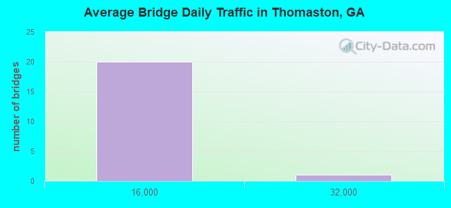
- 56,294Total average daily traffic
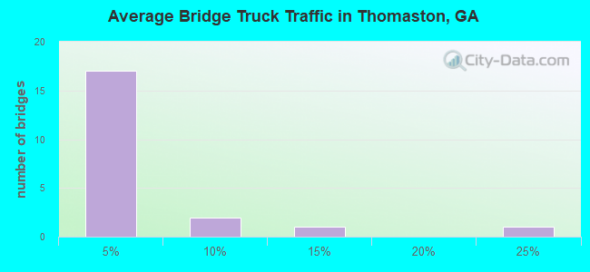
- 3,256Total average daily truck traffic
- National Bridge Inventory (NBI) Registered Bridges for Thomaston
- No street view available for this location
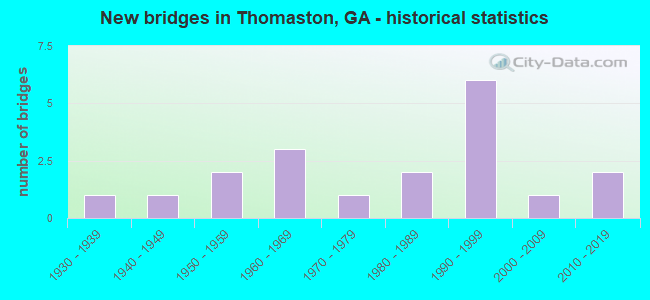
- New bridges - historical statistics
- 11930-1939
- 11940-1949
- 21950-1959
- 31960-1969
- 11970-1979
- 21980-1989
- 61990-1999
- 12000-2009
- 22010-2019
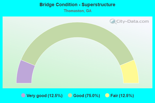
- Bridge Condition - Superstructure
- 12.5%Very good
- 75.0%Good
- 12.5%Fair
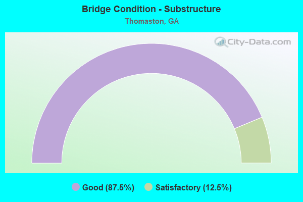
- Bridge Condition - Substructure
- 87.5%Good
- 12.5%Satisfactory
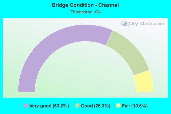
- Bridge Condition - Channel
- 63.2%Very good
- 26.3%Good
- 10.5%Fair
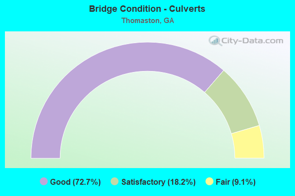
- Bridge Condition - Culverts
- 72.7%Good
- 18.2%Satisfactory
- 9.1%Fair
Find on map >> Show street view
Structure Number: 2930001, Location: 7 MI S OF THOMASTON (Lat: 32.794889, Lng: -84.265558), Route carried "on" structure: US 19, Year Built: 1972, Year Reconstructed: 1996, Status: Open, Structure Length: 9.14m (29.99ft), Average Daily Traffic: 2,520 (year 2012), Truck Traffic: 24%, Average Future Daily Traffic: 3,780 (year 2032), Design Load: HS 20+Mod, Features Intersected: TOBLER CREEK
Minimum Vertical Clearance: 30+ m (98+ ft), Kilometerpoint: 11.265, Lanes on structure: 2, Base Highway Network: Yes, Owner: State Highway Agency, Approaching Roadway Width: 9.1m (29.9ft), Skew: 10 degrees, Material/Design: Steel, Design/Construction: Stringer/Multi-beam, Number Of Spans In Main Unit: 5, Length of Maximum Span: 18.3m (60.0ft), Curb-To-Curb Width: 12.0m (39.4ft), Out-to-Out Width: 13.0m (42.7ft)
Condition: Deck: Good, Superstructure: Good, Substructure: Good, Channel: Very good, Operating Rating: 39.0 metric tons, Method Used To Determine Operating Rating: Load Factor (LF), Inventory Rating: 23.5 metric tons, Method Used To Determine Inventory Rating: Load Factor (LF), Structural Evaluation: Equal to present minimum criteria, Deck Geometry: Somewhat better than minimum adequacy, Waterway Adequacy: Equal to present desirable criteria, Approach Roadway Alignment: Equal to present desirable criteria, Designated Inspection Frequency: Every 24 months, Inspection Date: January 2022, Bridge Improvement Cost: $1,172,000, Roadway Improvement Cost: $117,000, Total Project Cost: $1,758,000, Deck Structure Type: Concrete Cast-file-Place
Find on map >> Show street view
Structure Number: 2930002, Location: 1 MI S OF THOMASTON (Lat: 32.868422, Lng: -84.321550), Route carried "on" structure: US 19, Year Built: 1938, Year Reconstructed: 1996, Status: Open, Structure Length: 0.64m (2.10ft), Average Daily Traffic: 5,400 (year 2012), Truck Traffic: 9%, Average Future Daily Traffic: 8,100 (year 2032), Design Load: H 15, Features Intersected: BELL CREEK
Minimum Vertical Clearance: 30+ m (98+ ft), Kilometerpoint: 22.531, Lanes on structure: 5, Base Highway Network: Yes, Owner: State Highway Agency, Approaching Roadway Width: 20.1m (65.9ft), Skew: 3 degrees, Material/Design: Concrete, Design/Construction: Culvert, Number Of Spans In Main Unit: 2, Length of Maximum Span: 3.0m (9.8ft)
Condition: Channel: Very good, Culverts: Good, Operating Rating: 41.7 metric tons, Method Used To Determine Operating Rating: Field evaluation and documented engineering judgment, Inventory Rating: 24.4 metric tons, Method Used To Determine Inventory Rating: Field evaluation and documented engineering judgment, Structural Evaluation: Equal to present minimum criteria, Waterway Adequacy: Equal to present desirable criteria, Approach Roadway Alignment: Better than present minimum criteria, Designated Inspection Frequency: Every 24 months, Inspection Date: January 2022, Bridge Improvement Cost: $149,000, Roadway Improvement Cost: $15,000, Total Project Cost: $224,000
Find on map >> Show street view
Structure Number: 2930011, Location: W CITY LMTS THOMASTON (Lat: 32.876631, Lng: -84.348972), Route carried "on" structure: State highway 36, Year Built: 1981, Status: Open, Structure Length: 0.88m (2.89ft), Average Daily Traffic: 2,620 (year 2012), Truck Traffic: 11%, Average Future Daily Traffic: 3,930 (year 2032), Design Load: HS 20+Mod, Features Intersected: TOWN BRANCH
Minimum Vertical Clearance: 30+ m (98+ ft), Kilometerpoint: 9.656, Lanes on structure: 2, Base Highway Network: Yes, Owner: State Highway Agency, Approaching Roadway Width: 7.3m (24.0ft), Material/Design: Concrete, Design/Construction: Culvert, Number Of Spans In Main Unit: 3, Length of Maximum Span: 2.7m (8.9ft)
Condition: Channel: Very good, Culverts: Good, Operating Rating: 55.3 metric tons, Method Used To Determine Operating Rating: Field evaluation and documented engineering judgment, Inventory Rating: 32.6 metric tons, Method Used To Determine Inventory Rating: Field evaluation and documented engineering judgment, Structural Evaluation: Better than present minimum criteria, Waterway Adequacy: Equal to present desirable criteria, Approach Roadway Alignment: Equal to present desirable criteria, Designated Inspection Frequency: Every 24 months, Inspection Date: January 2022, Bridge Improvement Cost: $113,000, Roadway Improvement Cost: $11,000, Total Project Cost: $170,000
Find on map >> Show street view
Structure Number: 2930014, Location: 3 MI E OF THOMASTON (Lat: 32.908236, Lng: -84.269106), Route carried "on" structure: State highway 74, Year Built: 1948, Status: Open, Structure Length: 0.67m (2.20ft), Average Daily Traffic: 2,400 (year 2012), Truck Traffic: 1%, Average Future Daily Traffic: 3,600 (year 2032), Design Load: H 15, Features Intersected: SWIFT CREEK TRIB
Minimum Vertical Clearance: 30+ m (98+ ft), Kilometerpoint: 28.968, Lanes on structure: 2, Base Highway Network: Yes, Owner: State Highway Agency, Approaching Roadway Width: 7.3m (24.0ft), Skew: 1 degrees, Material/Design: Concrete, Design/Construction: Culvert, Number Of Spans In Main Unit: 2, Length of Maximum Span: 3.0m (9.8ft)
Condition: Channel: Good, Culverts: Satisfactory, Operating Rating: 41.7 metric tons, Method Used To Determine Operating Rating: Field evaluation and documented engineering judgment, Inventory Rating: 24.4 metric tons, Method Used To Determine Inventory Rating: Field evaluation and documented engineering judgment, Structural Evaluation: Equal to present minimum criteria, Waterway Adequacy: Equal to present desirable criteria, Approach Roadway Alignment: Equal to present desirable criteria, Designated Inspection Frequency: Every 24 months, Inspection Date: January 2022, Bridge Improvement Cost: $86,000, Roadway Improvement Cost: $9,000, Total Project Cost: $129,000
Find on map >> Show street view
Structure Number: 2930023, Location: 5 MI SE OF THOMASTON (Lat: 32.850469, Lng: -84.254147), Route carried "on" structure: County highway 2913, Year Built: 1965, Status: Open, Structure Length: 1.01m (3.31ft), Average Daily Traffic: 390 (year 2012), Truck Traffic: 1%, Average Future Daily Traffic: 585 (year 2032), Design Load: H 15, Features Intersected: EAST SWIFT CREEK, Facility Carried by Structure: WAYNMANVILLE ROAD
Minimum Vertical Clearance: 30+ m (98+ ft), Kilometerpoint: 1.609, Lanes on structure: 2, Base Highway Network: Yes, Owner: County Highway Agency, Approaching Roadway Width: 6.4m (21.0ft), Skew: 1 degrees, Material/Design: Concrete, Design/Construction: Culvert, Number Of Spans In Main Unit: 3, Length of Maximum Span: 3.0m (9.8ft)
Condition: Channel: Good, Culverts: Good, Structural Evaluation: Better than present minimum criteria, Waterway Adequacy: Equal to present desirable criteria, Approach Roadway Alignment: Somewhat better than minimum adequacy, Designated Inspection Frequency: Every 24 months, Inspection Date: January 2022, Bridge Improvement Cost: $129,000, Roadway Improvement Cost: $13,000, Total Project Cost: $193,000
Find on map >> Show street view
Structure Number: 2930026, Location: 4 MI SE OF THOMASTON (Lat: 32.853933, Lng: -84.264350), Route carried "on" structure: City street 4400, Year Built: 1965, Status: Posted for load, Structure Length: 4.30m (14.11ft), Average Daily Traffic: 390 (year 2012), Truck Traffic: 1%, Average Future Daily Traffic: 585 (year 2032), Design Load: H 15, Features Intersected: SWIFT CREEK, Facility Carried by Structure: WAYMANVILLE ROAD
Minimum Vertical Clearance: 30+ m (98+ ft), Kilometerpoint: 8.047, Lanes on structure: 2, Base Highway Network: Yes, Owner: County Highway Agency, Approaching Roadway Width: 6.4m (21.0ft), Skew: 3 degrees, Material/Design: Steel, Design/Construction: Stringer/Multi-beam, Number Of Spans In Main Unit: 3, Length of Maximum Span: 14.3m (46.9ft), Curb or Sidewalk Widths: Left: 0.6m (2.0ft), Right: 0.6m (2.0ft), Curb-To-Curb Width: 7.9m (25.9ft), Out-to-Out Width: 9.8m (32.2ft)
Condition: Deck: Good, Superstructure: Good, Substructure: Good, Channel: Fair, Operating Rating: 22.6 metric tons, Method Used To Determine Operating Rating: Load Factor (LF), Inventory Rating: 13.6 metric tons, Method Used To Determine Inventory Rating: Load Factor (LF), Structural Evaluation: Meets minimum limits, Deck Geometry: Somewhat better than minimum adequacy, Waterway Adequacy: Equal to present desirable criteria, Approach Roadway Alignment: Better than present minimum criteria, Bridge Posting: Required (Relationship of Operating Rating to Maximum Legal Load: 20.0 - 29.9% below), Designated Inspection Frequency: Every 24 months, Inspection Date: Febuary 2022, Bridge Improvement Cost: $551,000, Roadway Improvement Cost: $55,000, Total Project Cost: $826,000, Deck Structure Type: Concrete Cast-file-Place, Wearing Surface/Protective System: Wearing Surface: Bituminous
Find on map >> Show street view
Structure Number: 2930031, Location: 7 MI N OF THOMASTON (Lat: 32.984439, Lng: -84.397628), Route carried "on" structure: County highway 2790, Year Built: 1959, Status: Open, Structure Length: 0.88m (2.89ft), Average Daily Traffic: 350 (year 2012), Truck Traffic: 1%, Average Future Daily Traffic: 525 (year 2032), Design Load: H 15, Features Intersected: TEN MILE CREEK, Facility Carried by Structure: SMYRNA CHURCH RD
Minimum Vertical Clearance: 30+ m (98+ ft), Kilometerpoint: 1.609, Lanes on structure: 2, Base Highway Network: Yes, Owner: County Highway Agency, Approaching Roadway Width: 5.8m (19.0ft), Material/Design: Concrete, Design/Construction: Culvert, Number Of Spans In Main Unit: 3, Length of Maximum Span: 2.7m (8.9ft)
Condition: Channel: Very good, Culverts: Fair, Operating Rating: 41.7 metric tons, Method Used To Determine Operating Rating: Field evaluation and documented engineering judgment, Inventory Rating: 24.4 metric tons, Method Used To Determine Inventory Rating: Field evaluation and documented engineering judgment, Structural Evaluation: Somewhat better than minimum adequacy, Waterway Adequacy: Equal to present minimum criteria, Approach Roadway Alignment: Better than present minimum criteria, Designated Inspection Frequency: Every 24 months, Inspection Date: January 2022, Bridge Improvement Cost: $113,000, Roadway Improvement Cost: $11,000, Total Project Cost: $170,000
Find on map >> Show street view
Structure Number: 2930032, Location: IN THOMASTON (Lat: 32.883947, Lng: -84.337828), Route carried "on" structure: City street 4404, Year Built: 1988, Status: Open, Structure Length: 1.13m (3.71ft), Average Daily Traffic: 1,510 (year 2012), Truck Traffic: 1%, Average Future Daily Traffic: 2,265 (year 2032), Design Load: H 15, Features Intersected: TOWN CREEK, Facility Carried by Structure: CHEROKEE ROAD
Minimum Vertical Clearance: 30+ m (98+ ft), Kilometerpoint: 1.609, Lanes on structure: 2, Base Highway Network: Yes, Owner: City or Municipal Highway Agency, Approaching Roadway Width: 7.9m (25.9ft), Skew: 3 degrees, Material/Design: Steel, Design/Construction: Culvert, Number Of Spans In Main Unit: 3, Length of Maximum Span: 3.0m (9.8ft)
Condition: Channel: Good, Culverts: Satisfactory, Operating Rating: 41.7 metric tons, Method Used To Determine Operating Rating: Field evaluation and documented engineering judgment, Inventory Rating: 24.4 metric tons, Method Used To Determine Inventory Rating: Field evaluation and documented engineering judgment, Structural Evaluation: Equal to present minimum criteria, Waterway Adequacy: Better than present minimum criteria, Approach Roadway Alignment: Better than present minimum criteria, Designated Inspection Frequency: Every 24 months, Inspection Date: January 2022, Bridge Improvement Cost: $145,000, Roadway Improvement Cost: $14,000, Total Project Cost: $217,000
Find on map >> Show street view
Structure Number: 2930034, Location: 2 MI W OF THOMASTON (Lat: 32.904456, Lng: -84.362461), Route carried "on" structure: State highway 74, Year Built: 1993, Status: Open, Structure Length: 8.53m (27.99ft), Average Daily Traffic: 4,110 (year 2012), Truck Traffic: 1%, Average Future Daily Traffic: 6,165 (year 2032), Design Load: HS 20+Mod, Features Intersected: POTATO CREEK
Minimum Vertical Clearance: 30+ m (98+ ft), Kilometerpoint: 17.703, Lanes on structure: 2, Base Highway Network: Yes, Owner: State Highway Agency, Approaching Roadway Width: 8.5m (27.9ft), Material/Design: Prestressed concrete, Design/Construction: Stringer/Multi-beam, Number Of Spans In Main Unit: 4, Length of Maximum Span: 21.3m (69.9ft), Curb-To-Curb Width: 13.4m (44.0ft), Out-to-Out Width: 14.5m (47.6ft)
Condition: Deck: Good, Superstructure: Good, Substructure: Good, Channel: Very good, Operating Rating: 57.1 metric tons, Method Used To Determine Operating Rating: Load Factor (LF), Inventory Rating: 34.4 metric tons, Method Used To Determine Inventory Rating: Load Factor (LF), Structural Evaluation: Better than present minimum criteria, Deck Geometry: Better than present minimum criteria, Waterway Adequacy: Equal to present desirable criteria, Approach Roadway Alignment: Equal to present minimum criteria, Designated Inspection Frequency: Every 24 months, Underwater Inspection Frequency: Every 60 months, Inspection Date: Febuary 2022, Underwater Inspection Date: June 2018, Bridge Improvement Cost: $1,094,000, Roadway Improvement Cost: $109,000, Total Project Cost: $1,641,000, Deck Structure Type: Concrete Cast-file-Place
Find on map >> Show street view
Structure Number: 2935012, Location: 4 MI S OF THOMASTON (Lat: 32.837947, Lng: -84.358789), Route carried "on" structure: County highway 129, Year Built: 1955, Status: Posted for load, Structure Length: 0.94m (3.08ft), Average Daily Traffic: 30 (year 2012), Truck Traffic: 1%, Average Future Daily Traffic: 45 (year 2032), Features Intersected: TOWN BRANCH, Facility Carried by Structure: GORDON SCHOOL RD
Minimum Vertical Clearance: 30+ m (98+ ft), Kilometerpoint: 0.000, Lanes on structure: 2, Base Highway Network: Yes, Owner: County Highway Agency, Approaching Roadway Width: 5.5m (18.0ft), Material/Design: Steel, Design/Construction: Stringer/Multi-beam, Number Of Spans In Main Unit: 1, Length of Maximum Span: 9.4m (30.8ft), Curb or Sidewalk Widths: Left: 0.2m (0.7ft), Right: 0.2m (0.7ft), Curb-To-Curb Width: 5.7m (18.7ft), Out-to-Out Width: 6.2m (20.3ft)
Condition: Deck: Good, Superstructure: Fair, Substructure: Good, Channel: Good, Operating Rating: 13.6 metric tons, Method Used To Determine Operating Rating: Load Factor (LF), Inventory Rating: 9.0 metric tons, Method Used To Determine Inventory Rating: Load Factor (LF), Structural Evaluation: High priority of replacement, Deck Geometry: Meets minimum limits, Waterway Adequacy: Equal to present minimum criteria, Approach Roadway Alignment: Meets minimum limits, Bridge Posting: Required (Relationship of Operating Rating to Maximum Legal Load: > 39.9% below), Length Of Structure Improvement: 41.15m (135.01ft), Designated Inspection Frequency: Every 24 months, Inspection Date: Febuary 2022, Bridge Improvement Cost: $121,000, Roadway Improvement Cost: $12,000, Total Project Cost: $182,000, Deck Structure Type: Wood or Timber
Find on map >> Show street view
Structure Number: 2935018, Location: 2 MI SE OF THOMASTON (Lat: 32.867156, Lng: -84.274294), Route carried "on" structure: County highway 192, Year Built: 1960, Status: Posted for load, Structure Length: 2.93m (9.61ft), Average Daily Traffic: 490 (year 2012), Truck Traffic: 1%, Average Future Daily Traffic: 735 (year 2032), Design Load: H 15, Features Intersected: SWIFT CREEK, Facility Carried by Structure: TRIUNE MILL ROAD
Minimum Vertical Clearance: 30+ m (98+ ft), Kilometerpoint: 4.828, Lanes on structure: 2, Base Highway Network: Yes, Owner: County Highway Agency, Approaching Roadway Width: 7.0m (23.0ft), Material/Design: Concrete, Design/Construction: Tee Beam, Number Of Spans In Main Unit: 3, Length of Maximum Span: 9.8m (32.2ft), Curb or Sidewalk Widths: Left: 0.6m (2.0ft), Right: 0.6m (2.0ft), Curb-To-Curb Width: 7.3m (24.0ft), Out-to-Out Width: 8.5m (27.9ft)
Condition: Deck: Good, Superstructure: Good, Substructure: Satisfactory, Channel: Fair, Operating Rating: 29.9 metric tons, Method Used To Determine Operating Rating: Load Factor (LF), Inventory Rating: 17.2 metric tons, Method Used To Determine Inventory Rating: Load Factor (LF), Structural Evaluation: Somewhat better than minimum adequacy, Deck Geometry: Meets minimum limits, Waterway Adequacy: Equal to present desirable criteria, Approach Roadway Alignment: Better than present minimum criteria, Bridge Posting: Required (Relationship of Operating Rating to Maximum Legal Load: 0.1 - 9.9% below), Length Of Structure Improvement: 9.36m (30.71ft), Designated Inspection Frequency: Every 24 months, Inspection Date: Febuary 2022, Bridge Improvement Cost: $375,000, Roadway Improvement Cost: $38,000, Total Project Cost: $563,000, Deck Structure Type: Concrete Cast-file-Place
Find on map >> Show street view
Structure Number: 293504, Location: 10 MI NW OF THOMASTON (Lat: 32.964047, Lng: -84.490011), Route carried "on" structure: County highway 429, Year Built: 1991, Status: Open, Structure Length: 2.93m (9.61ft), Average Daily Traffic: 490 (year 2012), Truck Traffic: 1%, Average Future Daily Traffic: 735 (year 2032), Design Load: HS 20, Features Intersected: SPRING CREEK, Facility Carried by Structure: LAWRENCE ROAD
Minimum Vertical Clearance: 30+ m (98+ ft), Kilometerpoint: 14.484, Lanes on structure: 2, Base Highway Network: Yes, Owner: County Highway Agency, Approaching Roadway Width: 6.1m (20.0ft), Material/Design: Prestressed concrete, Design/Construction: Stringer/Multi-beam, Number Of Spans In Main Unit: 2, Length of Maximum Span: 14.6m (47.9ft), Curb-To-Curb Width: 8.5m (27.9ft), Out-to-Out Width: 9.6m (31.5ft)
Condition: Deck: Good, Superstructure: Very good, Substructure: Good, Channel: Very good, Operating Rating: 51.7 metric tons, Method Used To Determine Operating Rating: Allowable Stress (AS), Inventory Rating: 31.7 metric tons, Method Used To Determine Inventory Rating: Allowable Stress (AS), Structural Evaluation: Better than present minimum criteria, Deck Geometry: Somewhat better than minimum adequacy, Waterway Adequacy: Equal to present desirable criteria, Approach Roadway Alignment: Somewhat better than minimum adequacy, Designated Inspection Frequency: Every 24 months, Inspection Date: January 2022, Bridge Improvement Cost: $375,000, Roadway Improvement Cost: $38,000, Total Project Cost: $563,000, Deck Structure Type: Concrete Cast-file-Place
Find on map >> Show street view
Structure Number: 2935047, Location: 2 MI W OF THOMASTON (Lat: 32.906847, Lng: -84.362700), Route carried "on" structure: County highway 69, Year Built: 1995, Status: Open, Structure Length: 1.01m (3.31ft), Average Daily Traffic: 240 (year 2012), Truck Traffic: 1%, Average Future Daily Traffic: 360 (year 2032), Design Load: HS 20+Mod, Features Intersected: BASIN CREEK, Facility Carried by Structure: BAKER BRITT ROAD
Minimum Vertical Clearance: 30+ m (98+ ft), Kilometerpoint: 0.000, Lanes on structure: 2, Base Highway Network: Yes, Owner: County Highway Agency, Approaching Roadway Width: 7.0m (23.0ft), Skew: 1 degrees, Material/Design: Concrete, Design/Construction: Culvert, Number Of Spans In Main Unit: 3, Length of Maximum Span: 3.0m (9.8ft)
Condition: Channel: Very good, Culverts: Good, Operating Rating: 55.3 metric tons, Method Used To Determine Operating Rating: Field evaluation and documented engineering judgment, Inventory Rating: 32.6 metric tons, Method Used To Determine Inventory Rating: Field evaluation and documented engineering judgment, Structural Evaluation: Better than present minimum criteria, Waterway Adequacy: Equal to present desirable criteria, Approach Roadway Alignment: Better than present minimum criteria, Designated Inspection Frequency: Every 24 months, Inspection Date: January 2022, Bridge Improvement Cost: $129,000, Roadway Improvement Cost: $13,000, Total Project Cost: $193,000
Find on map >> Show street view
Structure Number: 2935049, Location: 3 MI E OF THOMASTON (Lat: 32.905039, Lng: -84.260508), Route carried "on" structure: County highway 214, Year Built: 1995, Status: Open, Structure Length: 1.83m (6.00ft), Average Daily Traffic: 490 (year 2012), Truck Traffic: 1%, Average Future Daily Traffic: 735 (year 2032), Design Load: H 15, Features Intersected: SWIFT CREEK, Facility Carried by Structure: ANDREWS CHAPEL RD.
Minimum Vertical Clearance: 30+ m (98+ ft), Kilometerpoint: 3.219, Lanes on structure: 2, Base Highway Network: Yes, Owner: County Highway Agency, Approaching Roadway Width: 5.5m (18.0ft), Material/Design: Concrete, Design/Construction: Slab, Number Of Spans In Main Unit: 3, Length of Maximum Span: 6.1m (20.0ft), Curb-To-Curb Width: 7.4m (24.3ft), Out-to-Out Width: 8.1m (26.6ft)
Condition: Deck: Good, Superstructure: Good, Substructure: Good, Channel: Good, Operating Rating: 39.0 metric tons, Method Used To Determine Operating Rating: Allowable Stress (AS), Inventory Rating: 24.4 metric tons, Method Used To Determine Inventory Rating: Allowable Stress (AS), Structural Evaluation: Equal to present minimum criteria, Deck Geometry: Meets minimum limits, Waterway Adequacy: Better than present minimum criteria, Approach Roadway Alignment: Better than present minimum criteria, Designated Inspection Frequency: Every 24 months, Inspection Date: January 2022, Bridge Improvement Cost: $234,000, Roadway Improvement Cost: $23,000, Total Project Cost: $352,000, Deck Structure Type: Concrete Precast Panels
Find on map >> Show street view
Structure Number: 293505, Location: 5 MI N OF YATESVILLE (Lat: 32.972850, Lng: -84.168319), Route carried "on" structure: County highway 244, Year Built: 1995, Status: Open, Structure Length: 0.98m (3.22ft), Average Daily Traffic: 490 (year 2012), Truck Traffic: 1%, Average Future Daily Traffic: 735 (year 2032), Design Load: HS 20+Mod, Features Intersected: TOBLER CREEK, Facility Carried by Structure: BAILEY MILL ROAD
Minimum Vertical Clearance: 30+ m (98+ ft), Kilometerpoint: 1.609, Lanes on structure: 2, Base Highway Network: Yes, Owner: County Highway Agency, Approaching Roadway Width: 6.1m (20.0ft), Material/Design: Concrete, Design/Construction: Culvert, Number Of Spans In Main Unit: 3, Length of Maximum Span: 3.0m (9.8ft)
Condition: Channel: Very good, Culverts: Good, Operating Rating: 55.3 metric tons, Method Used To Determine Operating Rating: Field evaluation and documented engineering judgment, Inventory Rating: 32.6 metric tons, Method Used To Determine Inventory Rating: Field evaluation and documented engineering judgment, Structural Evaluation: Better than present minimum criteria, Waterway Adequacy: Equal to present desirable criteria, Approach Roadway Alignment: Meets minimum limits, Designated Inspection Frequency: Every 24 months, Inspection Date: January 2022, Bridge Improvement Cost: $125,000, Roadway Improvement Cost: $13,000, Total Project Cost: $188,000
Find on map >> Show street view
Structure Number: 2935053, Location: 5 MI S OF THOMASTON (Lat: 32.829328, Lng: -84.286519), Route carried "on" structure: County highway 164, Year Built: 1999, Status: Open, Structure Length: 0.88m (2.89ft), Average Daily Traffic: 490 (year 2012), Truck Traffic: 1%, Average Future Daily Traffic: 735 (year 2032), Design Load: HS 20+Mod, Features Intersected: WOLF CREEK, Facility Carried by Structure: NEW HARMONY ROAD
Minimum Vertical Clearance: 30+ m (98+ ft), Kilometerpoint: 3.219, Lanes on structure: 2, Base Highway Network: Yes, Owner: County Highway Agency, Approaching Roadway Width: 5.8m (19.0ft), Material/Design: Concrete, Design/Construction: Culvert, Number Of Spans In Main Unit: 3, Length of Maximum Span: 2.7m (8.9ft)
Condition: Channel: Very good, Culverts: Good, Structural Evaluation: Better than present minimum criteria, Waterway Adequacy: Equal to present desirable criteria, Approach Roadway Alignment: Equal to present minimum criteria, Designated Inspection Frequency: Every 24 months, Inspection Date: January 2022, Bridge Improvement Cost: $113,000, Roadway Improvement Cost: $11,000, Total Project Cost: $170,000
Find on map >> Show street view
Structure Number: 2935058, Location: 3 MI E OF THOMASTON (Lat: 32.887658, Lng: -84.269692), Route carried "on" structure: County highway 209, Year Built: 2007, Status: Open, Structure Length: 0.98m (3.22ft), Average Daily Traffic: 490 (year 2012), Truck Traffic: 1%, Average Future Daily Traffic: 735 (year 2032), Design Load: HS 20+Mod, Features Intersected: SWIFT CREEK, Facility Carried by Structure: TRICE CEMETARY ROA
Minimum Vertical Clearance: 30+ m (98+ ft), Kilometerpoint: 1.609, Lanes on structure: 2, Base Highway Network: Yes, Owner: County Highway Agency, Approaching Roadway Width: 6.1m (20.0ft), Material/Design: Concrete, Design/Construction: Culvert, Number Of Spans In Main Unit: 3, Length of Maximum Span: 3.0m (9.8ft)
Condition: Channel: Very good, Culverts: Good, Operating Rating: 55.3 metric tons, Method Used To Determine Operating Rating: Field evaluation and documented engineering judgment, Inventory Rating: 32.6 metric tons, Method Used To Determine Inventory Rating: Field evaluation and documented engineering judgment, Structural Evaluation: Better than present minimum criteria, Waterway Adequacy: Equal to present desirable criteria, Approach Roadway Alignment: Equal to present desirable criteria, Designated Inspection Frequency: Every 24 months, Inspection Date: January 2022, Bridge Improvement Cost: $125,000, Roadway Improvement Cost: $13,000, Total Project Cost: $188,000
Find on map >> Show street view
Structure Number: 293506, Location: 1 MI N OF THE ROCK (Lat: 32.981819, Lng: -84.240758), Route carried "on" structure: County highway 427, Year Built: 2010, Status: Open, Structure Length: 0.67m (2.20ft), Average Daily Traffic: 490 (year 2012), Truck Traffic: 1%, Average Future Daily Traffic: 735 (year 2032), Design Load: HS 20+Mod, Features Intersected: ROSE CREEK, Facility Carried by Structure: PIEDMONT ROAD
Minimum Vertical Clearance: 30+ m (98+ ft), Kilometerpoint: 6.437, Lanes on structure: 2, Base Highway Network: Yes, Owner: County Highway Agency, Approaching Roadway Width: 5.5m (18.0ft), Skew: 1 degrees, Material/Design: Concrete, Design/Construction: Culvert, Number Of Spans In Main Unit: 2, Length of Maximum Span: 3.0m (9.8ft)
Condition: Channel: Very good, Culverts: Good, Operating Rating: 55.3 metric tons, Method Used To Determine Operating Rating: Field evaluation and documented engineering judgment, Inventory Rating: 32.6 metric tons, Method Used To Determine Inventory Rating: Field evaluation and documented engineering judgment, Structural Evaluation: Better than present minimum criteria, Waterway Adequacy: Equal to present desirable criteria, Approach Roadway Alignment: Equal to present desirable criteria, Designated Inspection Frequency: Every 24 months, Inspection Date: Febuary 2022, Bridge Improvement Cost: $86,000, Roadway Improvement Cost: $9,000, Total Project Cost: $129,000
Find on map >> Show street view
Structure Number: 2935063, Location: IN THOMASTON (Lat: 32.916928, Lng: -84.333028), Route carried "on" structure: US 3, Year Built: 2013, Status: Open, Structure Length: 10.52m (34.51ft), Average Daily Traffic: 28,644 (year 2012), Truck Traffic: 6%, Average Future Daily Traffic: 38,192 (year 2031), Design Load: HS 20+Mod, Features Intersected: POTATO CREEK
Minimum Vertical Clearance: 30+ m (98+ ft), Kilometerpoint: 28.968, Lanes on structure: 5, Base Highway Network: Yes, Owner: State Highway Agency, Approaching Roadway Width: 17.1m (56.1ft), Material/Design: Prestressed concrete, Design/Construction: Stringer/Multi-beam, Number Of Spans In Main Unit: 3, Length of Maximum Span: 38.4m (126.0ft), Curb or Sidewalk Widths: Left: 1.8m (5.9ft), Right: 1.8m (5.9ft), Curb-To-Curb Width: 21.9m (71.9ft), Out-to-Out Width: 26.4m (86.6ft)
Condition: Deck: Good, Superstructure: Good, Substructure: Good, Channel: Very good, Operating Rating: 71.6 metric tons, Method Used To Determine Operating Rating: Load Factor (LF), Inventory Rating: 34.4 metric tons, Method Used To Determine Inventory Rating: Load Factor (LF), Structural Evaluation: Better than present minimum criteria, Deck Geometry: Somewhat better than minimum adequacy, Waterway Adequacy: Equal to present desirable criteria, Approach Roadway Alignment: Equal to present desirable criteria, Designated Inspection Frequency: Every 24 months, Inspection Date: Febuary 2022, Deck Structure Type: Concrete Cast-file-Place, Wearing Surface/Protective System: Wearing Surface: Latex Concrete
Find on map >> Show street view
Structure Number: 2935041, Location: CITY OF THOMASTON (Lat: 32.892378, Lng: -84.319019), Route carried "under" structure: City street 658, Structure Length: 0. m, Average Daily Traffic: 880 (year 2012), Truck Traffic: 1%, Features Intersected: CR 658 E WALKER STREET, Facility Carried by Structure: NS RAILROAD
Minimum Vertical Clearance: 30+ m (98+ ft), Kilometerpoint: 0.000, Length of Maximum Span: 0.0m
Find on map >> Show street view
Structure Number: 2935056, Location: CITY OF THOMASTON (Lat: 32.886458, Lng: -84.328083), Route carried "under" structure: State highway 36, Structure Length: 0. m, Average Daily Traffic: 3,380 (year 2012), Truck Traffic: 1%, Features Intersected: SR 36, Facility Carried by Structure: PEDESTRIAN OVERPAS
Minimum Vertical Clearance: 30+ m (98+ ft), Kilometerpoint: 12.875, Length of Maximum Span: 0.0m