Bridge Statistics for Templeton, Massachusetts (MA)
Condition, Traffic, Stress, Structural Evaluation, Project Costs
- National Bridge Inventory (NBI) Statistics
- 26Number of bridges
- 174ft / 53.2mTotal length
- $29,352,000Total costs
- 125,369Total average daily traffic
- 6,479Total average daily truck traffic
- National Bridge Inventory (NBI) Registered Bridges for Templeton
- No street view available for this location
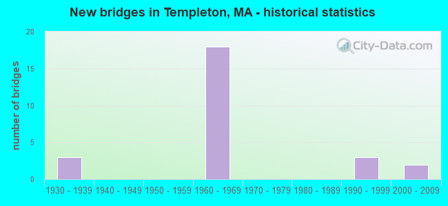
- New bridges - historical statistics
- 31930-1939
- 181960-1969
- 31990-1999
- 22000-2009


- Bridge Condition - Deck
- 11.1%Very good
- 27.8%Good
- 50.0%Satisfactory
- 11.1%Fair

- Bridge Condition - Superstructure
- 11.1%Very good
- 16.7%Good
- 44.4%Satisfactory
- 22.2%Fair
- 5.6%Poor

- Bridge Condition - Substructure
- 16.7%Good
- 72.2%Satisfactory
- 11.1%Fair

- Bridge Condition - Channel
- 20.0%Very good
- 60.0%Good
- 20.0%Satisfactory
Find on map >> Show street view
Structure Number: T02002ALADOTNBI, Location: US202 ELM ST/OTTER RIV (Lat: 42.606486, Lng: -72.075322), Route carried "on" structure: US , Year Built: 1999, Status: Open, Structure Length: 3.00m (9.84ft), Average Daily Traffic: 8,100 (year 2004), Truck Traffic: 5%, Average Future Daily Traffic: 15,793 (year 2031), Design Load: HS 20, Features Intersected: WATER OTTER RIVER, Facility Carried by Structure: US202 ELM ST
Minimum Vertical Clearance: 30+ m (98+ ft), Kilometerpoint: 111.988, Lanes on structure: 2, Owner: State Highway Agency, Approaching Roadway Width: 12.2m (40.0ft), Material/Design: Prestressed concrete, Design/Construction: Box Beam or Girders - Multiple, Number Of Spans In Main Unit: 1, Length of Maximum Span: 29.6m (97.1ft), Curb or Sidewalk Widths: Left: 1.8m (5.9ft), Right: 1.5m (4.9ft), Curb-To-Curb Width: 12.2m (40.0ft), Out-to-Out Width: 16.7m (54.8ft)
Condition: Deck: Satisfactory, Superstructure: Satisfactory, Substructure: Good, Channel: Good, Operating Rating: 60.5 metric tons, Method Used To Determine Operating Rating: Load Factor (LF), Inventory Rating: 47.3 metric tons, Method Used To Determine Inventory Rating: Load Factor (LF), Structural Evaluation: Equal to present minimum criteria, Deck Geometry: Somewhat better than minimum adequacy, Waterway Adequacy: Equal to present desirable criteria, Approach Roadway Alignment: Equal to present desirable criteria, Length Of Structure Improvement: 3.10m (10.17ft), Designated Inspection Frequency: Every 24 months, Inspection Date: December 2020, Bridge Improvement Cost: $351,000, Roadway Improvement Cost: $36,000, Total Project Cost: $527,000 ( Estimate for 2022), Deck Structure Type: Concrete Precast Panels, Wearing Surface/Protective System: Wearing Surface: Bituminous, Membrane: Preformed Fabric, Deck Protection: Epoxy Coated Reinforcing
Find on map >> Show street view
Structure Number: T0200416AMUNNBI, Location: .1 MI S OF JCT RTE 68 (Lat: 42.595889, Lng: -72.052481), Route carried "on" structure: City street , Year Built: 1938, Status: Temporarily open, Structure Length: 2.48m (8.14ft), Average Daily Traffic: 2,586 (year 2003), Truck Traffic: 10%, Average Future Daily Traffic: 4,084 (year 2032), Features Intersected: WATER OTTER RIVER, Facility Carried by Structure: HWY MAIN ST
Minimum Vertical Clearance: 30+ m (98+ ft), Kilometerpoint: 1.110, Lanes on structure: 2, Owner: Town or Township Highway Agency, Approaching Roadway Width: 8.8m (28.9ft), Material/Design: Steel continuous, Design/Construction: Stringer/Multi-beam, Number Of Spans In Main Unit: 3, Length of Maximum Span: 8.5m (27.9ft), Curb or Sidewalk Widths: Left: 1.7m (5.6ft), Right: 1.7m (5.6ft), Curb-To-Curb Width: 9.1m (29.9ft), Out-to-Out Width: 13.9m (45.6ft)
Condition: Deck: Fair, Superstructure: Poor, Substructure: Satisfactory, Channel: Satisfactory, Operating Rating: 82.9 metric tons, Method Used To Determine Operating Rating: Load Factor (LF), Inventory Rating: 49.7 metric tons, Method Used To Determine Inventory Rating: Load Factor (LF), Structural Evaluation: Meets minimum limits, Deck Geometry: Meets minimum limits, Waterway Adequacy: Better than present minimum criteria, Approach Roadway Alignment: Somewhat better than minimum adequacy, Length Of Structure Improvement: 2.50m (8.20ft), Designated Inspection Frequency: Every 12 months, Underwater Inspection Frequency: Every 34 months, Other Special Inspection Frequency: Every 12 months, Inspection Date: April 2021, Underwater Inspection Date: Febuary 2022, Other Special Inspection Date: April 2021, Bridge Improvement Cost: $1,365,000, Roadway Improvement Cost: $137,000, Total Project Cost: $2,048,000 ( Estimate for 2022), Deck Structure Type: Concrete Cast-file-Place, Wearing Surface/Protective System: Wearing Surface: Bituminous, Membrane: Built-up
Find on map >> Show street view
Structure Number: T0200517RMUNNBI, Location: 1000' S OF ST 68 (Lat: 42.593583, Lng: -72.046917), Route carried "on" structure: City street , Year Built: 1938, Status: Temporarily open, Structure Length: 2.90m (9.51ft), Average Daily Traffic: 1,000 (year 2018), Truck Traffic: 6%, Average Future Daily Traffic: 1,579 (year 2031), Features Intersected: WATER OTTER RIVER, Facility Carried by Structure: HWY HMLET MLL RD
Minimum Vertical Clearance: 30+ m (98+ ft), Kilometerpoint: 0.338, Lanes on structure: 2, Owner: Town or Township Highway Agency, Approaching Roadway Width: 6.1m (20.0ft), Material/Design: Steel continuous, Design/Construction: Stringer/Multi-beam, Number Of Spans In Main Unit: 3, Length of Maximum Span: 18.3m (60.0ft), Curb or Sidewalk Widths: Left: 0.2m (0.7ft), Right: 0.2m (0.7ft), Curb-To-Curb Width: 6.1m (20.0ft), Out-to-Out Width: 7.3m (24.0ft)
Condition: Deck: Fair, Superstructure: Fair, Substructure: Satisfactory, Channel: Good, Operating Rating: 66.4 metric tons, Method Used To Determine Operating Rating: Load Factor (LF), Inventory Rating: 39.8 metric tons, Method Used To Determine Inventory Rating: Load Factor (LF), Structural Evaluation: Somewhat better than minimum adequacy, Deck Geometry: High priority of corrective action, Waterway Adequacy: Equal to present desirable criteria, Approach Roadway Alignment: Somewhat better than minimum adequacy, Length Of Structure Improvement: 3.00m (9.84ft), Designated Inspection Frequency: Every 24 months, Underwater Inspection Frequency: Every 36 months, Inspection Date: July 2020, Underwater Inspection Date: December 2019, Bridge Improvement Cost: $861,000, Roadway Improvement Cost: $87,000, Total Project Cost: $1,292,000 ( Estimate for 2022), Deck Structure Type: Concrete Cast-file-Place, Wearing Surface/Protective System: Wearing Surface: Bituminous
Find on map >> Show street view
Structure Number: T02009AYGDOT634, Location: 300' E JCT US 202 (Lat: 42.610528, Lng: -72.074861), Route carried "on" structure: City street , Year Built: 2005, Status: Open, Structure Length: 1.46m (4.79ft), Average Daily Traffic: 4,784 (year 2018), Truck Traffic: 1%, Average Future Daily Traffic: 3,159 (year 2031), Design Load: HS 25 or greater, Features Intersected: RR BMRR, Facility Carried by Structure: HWY BRIDGE ST
Minimum Vertical Clearance: 30+ m (98+ ft), Kilometerpoint: 0.000, Lanes on structure: 2, Owner: State Highway Agency, Approaching Roadway Width: 7.5m (24.6ft), Skew: 1 degrees, Material/Design: Steel, Design/Construction: Stringer/Multi-beam, Number Of Spans In Main Unit: 1, Length of Maximum Span: 13.3m (43.6ft), Curb or Sidewalk Widths: Left: 1.6m (5.2ft), Right: 0.0m, Curb-To-Curb Width: 7.5m (24.6ft), Out-to-Out Width: 9.8m (32.2ft)
Condition: Deck: Very good, Superstructure: Very good, Substructure: Good, Operating Rating: 85.1 metric tons, Method Used To Determine Operating Rating: Load Factor (LF), Inventory Rating: 51.0 metric tons, Method Used To Determine Inventory Rating: Load Factor (LF), Structural Evaluation: Better than present minimum criteria, Deck Geometry: High priority of replacement, Underclear: Somewhat better than minimum adequacy, Approach Roadway Alignment: Meets minimum limits, Length Of Structure Improvement: 1.50m (4.92ft), Designated Inspection Frequency: Every 24 months, Inspection Date: June 2020, Bridge Improvement Cost: $835,000, Roadway Improvement Cost: $84,000, Total Project Cost: $1,253,000 ( Estimate for 2022), Deck Structure Type: Concrete Cast-file-Place, Wearing Surface/Protective System: Wearing Surface: Integral Concrete, Deck Protection: Epoxy Coated Reinforcing
Find on map >> Show street view
Structure Number: T020111AUDOT634, Location: 1.M S. JCT. ST 68 (Lat: 42.586111, Lng: -72.046000), Route carried "on" structure: City street , Year Built: 1992, Status: Open, Structure Length: 5.36m (17.59ft), Average Daily Traffic: 3,500 (year 2018), Truck Traffic: 15%, Average Future Daily Traffic: 2,859 (year 2032), Design Load: HS 20, Features Intersected: RR BMRR, Facility Carried by Structure: HWY DEPOT RD
Minimum Vertical Clearance: 30+ m (98+ ft), Kilometerpoint: 0.000, Lanes on structure: 2, Owner: State Highway Agency, Approaching Roadway Width: 10.1m (33.1ft), Skew: 5 degrees, Material/Design: Steel continuous, Design/Construction: Stringer/Multi-beam, Number Of Spans In Main Unit: 3, Length of Maximum Span: 20.0m (65.6ft), Curb or Sidewalk Widths: Left: 1.5m (4.9ft), Right: 0.0m, Curb-To-Curb Width: 9.8m (32.2ft), Out-to-Out Width: 12.3m (40.4ft)
Condition: Deck: Good, Superstructure: Satisfactory, Substructure: Satisfactory, Operating Rating: 84.4 metric tons, Method Used To Determine Operating Rating: Load Factor (LF), Inventory Rating: 50.6 metric tons, Method Used To Determine Inventory Rating: Load Factor (LF), Structural Evaluation: Equal to present minimum criteria, Deck Geometry: Meets minimum limits, Underclear: Meets minimum limits, Approach Roadway Alignment: Better than present minimum criteria, Length Of Structure Improvement: 5.40m (17.72ft), Designated Inspection Frequency: Every 24 months, Inspection Date: December 2021, Bridge Improvement Cost: $1,833,000, Roadway Improvement Cost: $184,000, Total Project Cost: $2,750,000 ( Estimate for 2022), Deck Structure Type: Concrete Cast-file-Place, Wearing Surface/Protective System: Wearing Surface: Bituminous, Membrane: Preformed Fabric, Deck Protection: Epoxy Coated Reinforcing
Find on map >> Show street view
Structure Number: T02014ANTDOTNBI, Location: .7M NW OF GARDNER T.L. (Lat: 42.597694, Lng: -72.050472), Route carried "on" structure: State highway 68, Year Built: 2002, Status: Open, Structure Length: 1.25m (4.10ft), Average Daily Traffic: 6,724 (year 2013), Truck Traffic: 9%, Average Future Daily Traffic: 7,896 (year 2032), Design Load: HS 20, Features Intersected: WATER BR OTTER RIVER
Minimum Vertical Clearance: 30+ m (98+ ft), Kilometerpoint: 33.795, Lanes on structure: 2, Owner: State Highway Agency, Approaching Roadway Width: 12.0m (39.4ft), Skew: 2 degrees, Material/Design: Prestressed concrete, Design/Construction: Slab, Number Of Spans In Main Unit: 1, Length of Maximum Span: 12.0m (39.4ft), Curb or Sidewalk Widths: Left: 2.0m (6.6ft), Right: 2.0m (6.6ft), Curb-To-Curb Width: 12.0m (39.4ft), Out-to-Out Width: 16.8m (55.1ft)
Condition: Deck: Good, Superstructure: Good, Substructure: Good, Channel: Good, Operating Rating: 79.5 metric tons, Method Used To Determine Operating Rating: Load Factor (LF), Inventory Rating: 43.9 metric tons, Method Used To Determine Inventory Rating: Load Factor (LF), Structural Evaluation: Better than present minimum criteria, Deck Geometry: Somewhat better than minimum adequacy, Waterway Adequacy: Equal to present desirable criteria, Approach Roadway Alignment: Equal to present minimum criteria, Length Of Structure Improvement: 1.30m (4.27ft), Designated Inspection Frequency: Every 24 months, Inspection Date: December 2021, Bridge Improvement Cost: $172,000, Roadway Improvement Cost: $18,000, Total Project Cost: $259,000 ( Estimate for 2022), Deck Structure Type: Concrete Precast Panels, Wearing Surface/Protective System: Wearing Surface: Bituminous, Membrane: Preformed Fabric
Find on map >> Show street view
Structure Number: T02019169MUNNBI, Location: 0.1M N OF RTE 101 (Lat: 42.563306, Lng: -72.038306), Route carried "on" structure: City street , Year Built: 1938, Year Reconstructed: 2014, Status: Open, Structure Length: 0.94m (3.08ft), Average Daily Traffic: 3,800 (year 2003), Truck Traffic: 10%, Average Future Daily Traffic: 6,001 (year 2032), Design Load: HL 93, Features Intersected: WATER E TEMPLTN PND OTLT, Facility Carried by Structure: HWY N MAIN ST
Minimum Vertical Clearance: 30+ m (98+ ft), Kilometerpoint: 2.028, Lanes on structure: 2, Owner: Town or Township Highway Agency, Approaching Roadway Width: 11.5m (37.7ft), Material/Design: Steel, Design/Construction: Stringer/Multi-beam, Number Of Spans In Main Unit: 1, Length of Maximum Span: 8.1m (26.6ft), Curb or Sidewalk Widths: Left: 1.6m (5.2ft), Right: 0.0m, Curb-To-Curb Width: 8.9m (29.2ft), Out-to-Out Width: 11.4m (37.4ft)
Condition: Deck: Very good, Superstructure: Very good, Substructure: Satisfactory, Channel: Very good, Operating Rating: 94.0 metric tons, Method Used To Determine Operating Rating: Load and Resistance Factor Rating (LRFR) rating reported by rating factor(RF) method using HL-93 loadings, Inventory Rating: 74.5 metric tons, Method Used To Determine Inventory Rating: Load and Resistance Factor Rating (LRFR) rating reported by rating factor(RF) method using HL-93 loadings, Structural Evaluation: Equal to present minimum criteria, Deck Geometry: Meets minimum limits, Waterway Adequacy: Equal to present desirable criteria, Approach Roadway Alignment: Superior to present desirable criteria, Designated Inspection Frequency: Every 24 months, Inspection Date: January 2021, Deck Structure Type: Concrete Cast-file-Place, Wearing Surface/Protective System: Wearing Surface: Bituminous, Membrane: Preformed Fabric, Deck Protection: Other Coated Reinforcing
Find on map >> Show street view
Structure Number: T02021AAPDOT634, Location: 0.1 M S OF WINCHENDON RD (Lat: 42.615083, Lng: -72.077689), Route carried "on" structure: US 202, Year Built: 1994, Status: Open, Structure Length: 5.89m (19.32ft), Average Daily Traffic: 5,560 (year 2019), Truck Traffic: 5%, Average Future Daily Traffic: 7,352 (year 2032), Design Load: HS 20, Features Intersected: RR BMRR
Minimum Vertical Clearance: 30+ m (98+ ft), Kilometerpoint: 113.214, Lanes on structure: 2, Owner: State Highway Agency, Approaching Roadway Width: 12.2m (40.0ft), Skew: 5 degrees, Material/Design: Steel continuous, Design/Construction: Stringer/Multi-beam, Number Of Spans In Main Unit: 3, Length of Maximum Span: 24.8m (81.4ft), Curb or Sidewalk Widths: Left: 0.0m, Right: 2.1m (6.9ft), Curb-To-Curb Width: 12.2m (40.0ft), Out-to-Out Width: 15.2m (49.9ft)
Condition: Deck: Satisfactory, Superstructure: Good, Substructure: Satisfactory, Operating Rating: 55.1 metric tons, Method Used To Determine Operating Rating: Allowable Stress (AS), Inventory Rating: 35.7 metric tons, Method Used To Determine Inventory Rating: Allowable Stress (AS), Structural Evaluation: Equal to present minimum criteria, Deck Geometry: Somewhat better than minimum adequacy, Underclear: Somewhat better than minimum adequacy, Approach Roadway Alignment: Equal to present desirable criteria, Length Of Structure Improvement: 5.90m (19.36ft), Designated Inspection Frequency: Every 24 months, Inspection Date: January 2021, Bridge Improvement Cost: $668,000, Roadway Improvement Cost: $67,000, Total Project Cost: $1,003,000 ( Estimate for 2022), Deck Structure Type: Concrete Cast-file-Place, Wearing Surface/Protective System: Wearing Surface: Bituminous, Membrane: Preformed Fabric, Deck Protection: Epoxy Coated Reinforcing
Find on map >> Show street view
Structure Number: T0202219JDOTNBI, Location: MM 80.5 ON ST 2 EB (Lat: 42.567733, Lng: -72.101042), Route carried "on" structure: State highway 2, Year Built: 1969, Status: Open, Structure Length: 3.23m (10.60ft), Average Daily Traffic: 9,381 (year 2019), Truck Traffic: 9%, Average Future Daily Traffic: 33,165 (year 2031), Design Load: H 20, Features Intersected: ST 2 A/PATRIOTS RD
Minimum Vertical Clearance: 30+ m (98+ ft), Kilometerpoint: 129.468, Lanes on structure: 2, Lanes under structure: 2, Base Highway Network: Yes, Owner: State Highway Agency, Approaching Roadway Width: 12.3m (40.4ft), Skew: 4 degrees, Material/Design: Steel, Design/Construction: Stringer/Multi-beam, Number Of Spans In Main Unit: 1, Length of Maximum Span: 30.6m (100.4ft), Curb-To-Curb Width: 12.3m (40.4ft), Out-to-Out Width: 13.8m (45.3ft)
Condition: Deck: Satisfactory, Superstructure: Fair, Substructure: Fair, Operating Rating: 58.2 metric tons, Method Used To Determine Operating Rating: Load Factor (LF), Inventory Rating: 34.8 metric tons, Method Used To Determine Inventory Rating: Load Factor (LF), Structural Evaluation: Somewhat better than minimum adequacy, Deck Geometry: Better than present minimum criteria, Underclear: High priority of corrective action, Approach Roadway Alignment: Equal to present desirable criteria, Length Of Structure Improvement: 3.30m (10.83ft), Designated Inspection Frequency: Every 24 months, Inspection Date: April 2020, Bridge Improvement Cost: $1,789,000, Roadway Improvement Cost: $179,000, Total Project Cost: $2,684,000 ( Estimate for 2022), Deck Structure Type: Concrete Cast-file-Place, Wearing Surface/Protective System: Wearing Surface: Bituminous, Membrane: Preformed Fabric
Find on map >> Show street view
Structure Number: T0202219KDOTNBI, Location: MM 80.5 ON ST 2 WB (Lat: 42.568242, Lng: -72.101800), Route carried "on" structure: State highway 2, Year Built: 1969, Status: Open, Structure Length: 3.02m (9.91ft), Average Daily Traffic: 11,196 (year 2019), Truck Traffic: 9%, Average Future Daily Traffic: 33,165 (year 2031), Design Load: H 20, Features Intersected: ST 2 A/PATRIOTS RD
Minimum Vertical Clearance: 30+ m (98+ ft), Kilometerpoint: 129.468, Lanes on structure: 2, Lanes under structure: 2, Base Highway Network: Yes, Owner: State Highway Agency, Approaching Roadway Width: 12.3m (40.4ft), Skew: 3 degrees, Material/Design: Steel, Design/Construction: Stringer/Multi-beam, Number Of Spans In Main Unit: 1, Length of Maximum Span: 28.8m (94.5ft), Curb-To-Curb Width: 12.3m (40.4ft), Out-to-Out Width: 13.8m (45.3ft)
Condition: Deck: Satisfactory, Superstructure: Fair, Substructure: Fair, Operating Rating: 58.2 metric tons, Method Used To Determine Operating Rating: Load Factor (LF), Inventory Rating: 34.8 metric tons, Method Used To Determine Inventory Rating: Load Factor (LF), Structural Evaluation: Somewhat better than minimum adequacy, Deck Geometry: Better than present minimum criteria, Underclear: High priority of corrective action, Approach Roadway Alignment: Equal to present desirable criteria, Length Of Structure Improvement: 3.10m (10.17ft), Designated Inspection Frequency: Every 24 months, Inspection Date: April 2020, Bridge Improvement Cost: $1,681,000, Roadway Improvement Cost: $169,000, Total Project Cost: $2,522,000 ( Estimate for 2022), Deck Structure Type: Concrete Cast-file-Place, Wearing Surface/Protective System: Wearing Surface: Bituminous, Membrane: Preformed Fabric
Find on map >> Show street view
Structure Number: T0202419GDOTNBI, Location: MM 81.9 ON ST 2 EB (Lat: 42.569592, Lng: -72.072739), Route carried "on" structure: City street , Year Built: 1969, Status: Open, Structure Length: 2.86m (9.38ft), Average Daily Traffic: 4,138 (year 2018), Truck Traffic: 6%, Average Future Daily Traffic: 9,634 (year 2031), Design Load: H 20, Features Intersected: ST 2 EB, Facility Carried by Structure: HWY BLDWNVLLE RD
Minimum Vertical Clearance: 30+ m (98+ ft), Kilometerpoint: 0.000, Lanes on structure: 2, Lanes under structure: 2, Owner: State Highway Agency, Approaching Roadway Width: 13.4m (44.0ft), Skew: 1 degrees, Material/Design: Steel, Design/Construction: Stringer/Multi-beam, Number Of Spans In Main Unit: 1, Length of Maximum Span: 27.1m (88.9ft), Curb or Sidewalk Widths: Left: 0.5m (1.6ft), Right: 1.5m (4.9ft), Curb-To-Curb Width: 13.4m (44.0ft), Out-to-Out Width: 16.2m (53.1ft)
Condition: Deck: Good, Superstructure: Good, Substructure: Satisfactory, Operating Rating: 58.8 metric tons, Method Used To Determine Operating Rating: Load Factor (LF), Inventory Rating: 35.2 metric tons, Method Used To Determine Inventory Rating: Load Factor (LF), Structural Evaluation: Equal to present minimum criteria, Deck Geometry: Better than present minimum criteria, Underclear: Equal to present minimum criteria, Approach Roadway Alignment: Equal to present desirable criteria, Length Of Structure Improvement: 2.90m (9.51ft), Designated Inspection Frequency: Every 24 months, Inspection Date: December 2020, Bridge Improvement Cost: $370,000, Roadway Improvement Cost: $38,000, Total Project Cost: $556,000 ( Estimate for 2022), Deck Structure Type: Concrete Cast-file-Place, Wearing Surface/Protective System: Wearing Surface: Bituminous, Membrane: Built-up
Find on map >> Show street view
Structure Number: T0202419HDOTNBI, Location: MM 81.9 ON ST 2 EB (Lat: 42.570219, Lng: -72.072747), Route carried "on" structure: City street , Year Built: 1969, Status: Open, Structure Length: 2.86m (9.38ft), Average Daily Traffic: 4,138 (year 2018), Truck Traffic: 6%, Average Future Daily Traffic: 9,634 (year 2031), Design Load: H 20, Features Intersected: ST 2 WB, Facility Carried by Structure: HWY BLDWNVLLE RD
Minimum Vertical Clearance: 30+ m (98+ ft), Kilometerpoint: 0.000, Lanes on structure: 2, Lanes under structure: 2, Owner: State Highway Agency, Approaching Roadway Width: 13.4m (44.0ft), Skew: 1 degrees, Material/Design: Steel, Design/Construction: Stringer/Multi-beam, Number Of Spans In Main Unit: 1, Length of Maximum Span: 27.1m (88.9ft), Curb or Sidewalk Widths: Left: 0.5m (1.6ft), Right: 1.5m (4.9ft), Curb-To-Curb Width: 13.4m (44.0ft), Out-to-Out Width: 16.2m (53.1ft)
Condition: Deck: Good, Superstructure: Satisfactory, Substructure: Satisfactory, Operating Rating: 58.8 metric tons, Method Used To Determine Operating Rating: Load Factor (LF), Inventory Rating: 35.2 metric tons, Method Used To Determine Inventory Rating: Load Factor (LF), Structural Evaluation: Equal to present minimum criteria, Deck Geometry: Better than present minimum criteria, Underclear: Somewhat better than minimum adequacy, Approach Roadway Alignment: Equal to present desirable criteria, Length Of Structure Improvement: 2.90m (9.51ft), Designated Inspection Frequency: Every 24 months, Inspection Date: December 2020, Bridge Improvement Cost: $370,000, Roadway Improvement Cost: $38,000, Total Project Cost: $556,000 ( Estimate for 2022), Deck Structure Type: Concrete Cast-file-Place, Wearing Surface/Protective System: Wearing Surface: Bituminous, Membrane: Built-up
Find on map >> Show street view
Structure Number: T0202519EDOTNBI, Location: MM 83.9 ON ST 2 EB (Lat: 42.564639, Lng: -72.058361), Route carried "on" structure: City street , Year Built: 1969, Status: Open, Structure Length: 2.96m (9.71ft), Average Daily Traffic: 905 (year 2018), Truck Traffic: 14%, Average Future Daily Traffic: 1,106 (year 2031), Design Load: H 20, Features Intersected: ST 2 EB, Facility Carried by Structure: HWY OTTR RIV RD
Minimum Vertical Clearance: 30+ m (98+ ft), Kilometerpoint: 0.000, Lanes on structure: 2, Lanes under structure: 2, Owner: State Highway Agency, Approaching Roadway Width: 9.8m (32.2ft), Skew: 1 degrees, Material/Design: Steel, Design/Construction: Stringer/Multi-beam, Number Of Spans In Main Unit: 1, Length of Maximum Span: 27.8m (91.2ft), Curb or Sidewalk Widths: Left: 1.5m (4.9ft), Right: 0.5m (1.6ft), Curb-To-Curb Width: 9.8m (32.2ft), Out-to-Out Width: 12.6m (41.3ft)
Condition: Deck: Satisfactory, Superstructure: Satisfactory, Substructure: Satisfactory, Operating Rating: 52.2 metric tons, Method Used To Determine Operating Rating: Load Factor (LF), Inventory Rating: 31.2 metric tons, Method Used To Determine Inventory Rating: Load Factor (LF), Structural Evaluation: Equal to present minimum criteria, Deck Geometry: Equal to present minimum criteria, Underclear: Equal to present minimum criteria, Approach Roadway Alignment: Equal to present desirable criteria, Length Of Structure Improvement: 3.00m (9.84ft), Designated Inspection Frequency: Every 24 months, Inspection Date: November 2020, Bridge Improvement Cost: $1,485,000, Roadway Improvement Cost: $149,000, Total Project Cost: $2,228,000 ( Estimate for 2022), Deck Structure Type: Concrete Cast-file-Place, Wearing Surface/Protective System: Wearing Surface: Bituminous, Membrane: Preformed Fabric
Find on map >> Show street view
Structure Number: T0202519FDOTNBI, Location: MM 83.9 ON ST 2 WB (Lat: 42.565167, Lng: -72.058167), Route carried "on" structure: City street , Year Built: 1969, Status: Open, Structure Length: 3.15m (10.33ft), Average Daily Traffic: 905 (year 2018), Truck Traffic: 14%, Average Future Daily Traffic: 1,106 (year 2031), Design Load: H 20, Features Intersected: ST 2 WB, Facility Carried by Structure: HWY OTTR RIV RD
Minimum Vertical Clearance: 30+ m (98+ ft), Kilometerpoint: 0.000, Lanes on structure: 2, Lanes under structure: 2, Owner: State Highway Agency, Approaching Roadway Width: 9.8m (32.2ft), Skew: 2 degrees, Material/Design: Steel, Design/Construction: Stringer/Multi-beam, Number Of Spans In Main Unit: 1, Length of Maximum Span: 29.5m (96.8ft), Curb or Sidewalk Widths: Left: 1.5m (4.9ft), Right: 0.5m (1.6ft), Curb-To-Curb Width: 9.8m (32.2ft), Out-to-Out Width: 12.6m (41.3ft)
Condition: Deck: Satisfactory, Superstructure: Satisfactory, Substructure: Satisfactory, Operating Rating: 53.1 metric tons, Method Used To Determine Operating Rating: Load Factor (LF), Inventory Rating: 31.8 metric tons, Method Used To Determine Inventory Rating: Load Factor (LF), Structural Evaluation: Equal to present minimum criteria, Deck Geometry: Equal to present minimum criteria, Underclear: Somewhat better than minimum adequacy, Approach Roadway Alignment: Equal to present desirable criteria, Length Of Structure Improvement: 3.20m (10.50ft), Designated Inspection Frequency: Every 24 months, Inspection Date: November 2020, Bridge Improvement Cost: $1,584,000, Roadway Improvement Cost: $159,000, Total Project Cost: $2,377,000 ( Estimate for 2022), Deck Structure Type: Concrete Cast-file-Place, Wearing Surface/Protective System: Wearing Surface: Bituminous, Membrane: Preformed Fabric
Find on map >> Show street view
Structure Number: T0202618PDOTNBI, Location: AT EXIT 83 (Lat: 42.558028, Lng: -72.046722), Route carried "on" structure: Alternate State highway 2, Year Built: 1969, Status: Open, Structure Length: 3.18m (10.43ft), Average Daily Traffic: 13,000 (year 2019), Truck Traffic: 3%, Average Future Daily Traffic: 7,148 (year 2032), Design Load: H 20, Features Intersected: ST 2 WB
Minimum Vertical Clearance: 30+ m (98+ ft), Kilometerpoint: 14.097, Lanes on structure: 2, Lanes under structure: 2, Owner: State Highway Agency, Approaching Roadway Width: 14.0m (45.9ft), Skew: 3 degrees, Material/Design: Steel, Design/Construction: Stringer/Multi-beam, Number Of Spans In Main Unit: 1, Length of Maximum Span: 30.6m (100.4ft), Curb or Sidewalk Widths: Left: 0.5m (1.6ft), Right: 1.5m (4.9ft), Curb-To-Curb Width: 14.0m (45.9ft), Out-to-Out Width: 16.8m (55.1ft)
Condition: Deck: Satisfactory, Superstructure: Fair, Substructure: Satisfactory, Operating Rating: 53.2 metric tons, Method Used To Determine Operating Rating: Load Factor (LF), Inventory Rating: 31.9 metric tons, Method Used To Determine Inventory Rating: Load Factor (LF), Structural Evaluation: Somewhat better than minimum adequacy, Deck Geometry: Superior to present desirable criteria, Underclear: Meets minimum limits, Approach Roadway Alignment: Equal to present desirable criteria, Length Of Structure Improvement: 3.20m (10.50ft), Designated Inspection Frequency: Every 24 months, Inspection Date: November 2021, Bridge Improvement Cost: $2,112,000, Roadway Improvement Cost: $212,000, Total Project Cost: $3,169,000 ( Estimate for 2022), Deck Structure Type: Concrete Cast-file-Place, Wearing Surface/Protective System: Wearing Surface: Bituminous, Membrane: Built-up
Find on map >> Show street view
Structure Number: T0202618QDOTNBI, Location: AT EXIT 83 (Lat: 42.557750, Lng: -72.047500), Route carried "on" structure: Alternate State highway 2, Year Built: 1969, Status: Open, Structure Length: 3.00m (9.84ft), Average Daily Traffic: 13,000 (year 2019), Truck Traffic: 3%, Average Future Daily Traffic: 7,148 (year 2032), Design Load: H 20, Features Intersected: ST 2 EB
Minimum Vertical Clearance: 30+ m (98+ ft), Kilometerpoint: 14.097, Lanes on structure: 2, Lanes under structure: 2, Owner: State Highway Agency, Approaching Roadway Width: 14.0m (45.9ft), Skew: 2 degrees, Material/Design: Steel, Design/Construction: Stringer/Multi-beam, Number Of Spans In Main Unit: 1, Length of Maximum Span: 28.8m (94.5ft), Curb or Sidewalk Widths: Left: 0.5m (1.6ft), Right: 1.5m (4.9ft), Curb-To-Curb Width: 14.0m (45.9ft), Out-to-Out Width: 16.8m (55.1ft)
Condition: Deck: Satisfactory, Superstructure: Satisfactory, Substructure: Satisfactory, Operating Rating: 50.3 metric tons, Method Used To Determine Operating Rating: Load Factor (LF), Inventory Rating: 30.1 metric tons, Method Used To Determine Inventory Rating: Load Factor (LF), Structural Evaluation: Equal to present minimum criteria, Deck Geometry: Superior to present desirable criteria, Underclear: Somewhat better than minimum adequacy, Approach Roadway Alignment: Equal to present desirable criteria, Length Of Structure Improvement: 3.10m (10.17ft), Designated Inspection Frequency: Every 24 months, Inspection Date: November 2021, Bridge Improvement Cost: $2,046,000, Roadway Improvement Cost: $205,000, Total Project Cost: $3,070,000 ( Estimate for 2022), Deck Structure Type: Concrete Cast-file-Place, Wearing Surface/Protective System: Wearing Surface: Bituminous, Membrane: Built-up
Find on map >> Show street view
Structure Number: T0202719CDOTNBI, Location: MM 84.0 ON ST 2 EB (Lat: 42.554694, Lng: -72.036250), Route carried "on" structure: Other road , Year Built: 1969, Status: Open, Structure Length: 2.83m (9.28ft), Average Daily Traffic: 2,716 (year 2018), Truck Traffic: 10%, Average Future Daily Traffic: 2,369 (year 2031), Design Load: H 20, Features Intersected: ST 2 EB, Facility Carried by Structure: HWY S MAIN ST
Minimum Vertical Clearance: 30+ m (98+ ft), Kilometerpoint: 0.000, Lanes on structure: 2, Lanes under structure: 2, Owner: State Highway Agency, Approaching Roadway Width: 12.1m (39.7ft), Skew: 1 degrees, Material/Design: Steel, Design/Construction: Stringer/Multi-beam, Number Of Spans In Main Unit: 1, Length of Maximum Span: 26.8m (87.9ft), Curb or Sidewalk Widths: Left: 0.5m (1.6ft), Right: 1.5m (4.9ft), Curb-To-Curb Width: 12.2m (40.0ft), Out-to-Out Width: 15.0m (49.2ft)
Condition: Deck: Good, Superstructure: Satisfactory, Substructure: Satisfactory, Operating Rating: 57.4 metric tons, Method Used To Determine Operating Rating: Load Factor (LF), Inventory Rating: 34.4 metric tons, Method Used To Determine Inventory Rating: Load Factor (LF), Structural Evaluation: Equal to present minimum criteria, Deck Geometry: Equal to present minimum criteria, Underclear: Equal to present minimum criteria, Approach Roadway Alignment: Equal to present desirable criteria, Length Of Structure Improvement: 2.90m (9.51ft), Designated Inspection Frequency: Every 24 months, Inspection Date: November 2020, Bridge Improvement Cost: $329,000, Roadway Improvement Cost: $33,000, Total Project Cost: $494,000 ( Estimate for 2022), Deck Structure Type: Concrete Cast-file-Place, Wearing Surface/Protective System: Wearing Surface: Bituminous, Membrane: Preformed Fabric
Find on map >> Show street view
Structure Number: T0202819DDOTNBI, Location: MM 84.0 ON ST 2 WB (Lat: 42.556111, Lng: -72.036556), Route carried "on" structure: Other road , Year Built: 1969, Status: Open, Structure Length: 2.81m (9.22ft), Average Daily Traffic: 2,716 (year 2018), Truck Traffic: 10%, Average Future Daily Traffic: 2,369 (year 2031), Design Load: H 20, Features Intersected: ST 2 WB, Facility Carried by Structure: HWY S MAIN ST
Minimum Vertical Clearance: 30+ m (98+ ft), Kilometerpoint: 0.000, Lanes on structure: 2, Lanes under structure: 2, Owner: State Highway Agency, Approaching Roadway Width: 12.2m (40.0ft), Material/Design: Steel, Design/Construction: Stringer/Multi-beam, Number Of Spans In Main Unit: 1, Length of Maximum Span: 26.4m (86.6ft), Curb or Sidewalk Widths: Left: 0.5m (1.6ft), Right: 1.5m (4.9ft), Curb-To-Curb Width: 12.2m (40.0ft), Out-to-Out Width: 15.0m (49.2ft)
Condition: Deck: Satisfactory, Superstructure: Satisfactory, Substructure: Satisfactory, Operating Rating: 52.9 metric tons, Method Used To Determine Operating Rating: Allowable Stress (AS), Inventory Rating: 25.3 metric tons, Method Used To Determine Inventory Rating: Allowable Stress (AS), Structural Evaluation: Equal to present minimum criteria, Deck Geometry: Equal to present minimum criteria, Underclear: Somewhat better than minimum adequacy, Approach Roadway Alignment: Equal to present desirable criteria, Length Of Structure Improvement: 2.90m (9.51ft), Designated Inspection Frequency: Every 24 months, Inspection Date: November 2020, Bridge Improvement Cost: $1,709,000, Roadway Improvement Cost: $171,000, Total Project Cost: $2,564,000 ( Estimate for 2022), Deck Structure Type: Concrete Cast-file-Place, Wearing Surface/Protective System: Wearing Surface: Bituminous, Membrane: Preformed Fabric
Find on map >> Show street view
Structure Number: T0202419GDOTNBI, Location: BALDWINVILLE RD/ST 2EB (Lat: 42.566667, Lng: -72.066667), Route carried "under" structure: State highway 2, Year Built: 1969, Structure Length: 0. m, Average Daily Traffic: 4,000 (year 0000), Features Intersected: ST 2 EB, Facility Carried by Structure: HWY BLDWINVIL RD
Minimum Vertical Clearance: 4.42m (14.50ft), Kilometerpoint: 0.000, Lanes on structure: 2, Lanes under structure: 2, Material/Design: Steel, Design/Construction: Stringer/Multi-beam, Length of Maximum Span: 27.4m (89.9ft)
Find on map >> Show street view
Structure Number: T0202419HDOTNBI, Location: BALDWINVILLE RD/ST 2WB (Lat: 42.566667, Lng: -72.066667), Route carried "under" structure: State highway 2, Year Built: 1969, Structure Length: 0. m, Average Daily Traffic: 4,000 (year 0000), Features Intersected: ST 2 WB, Facility Carried by Structure: HWY BLDWINVIL RD
Minimum Vertical Clearance: 4.42m (14.50ft), Kilometerpoint: 0.000, Lanes on structure: 2, Lanes under structure: 2, Material/Design: Steel, Design/Construction: Stringer/Multi-beam, Length of Maximum Span: 27.4m (89.9ft)
Find on map >> Show street view
Structure Number: T0202519EDOTNBI, Location: OTTER RIV RD/ST 2EB (Lat: 42.566667, Lng: -72.066667), Route carried "under" structure: State highway 2, Year Built: 1969, Structure Length: 0. m, Average Daily Traffic: 4,000 (year 0000), Features Intersected: ST 2 EB, Facility Carried by Structure: HWY OTTER RIV RD
Minimum Vertical Clearance: 4.42m (14.50ft), Kilometerpoint: 0.000, Lanes on structure: 2, Lanes under structure: 2, Material/Design: Steel, Design/Construction: Stringer/Multi-beam, Length of Maximum Span: 28.0m (91.9ft)
Find on map >> Show street view
Structure Number: T0202519FDOTNBI, Location: OTTER RIV RD/ST 2WB (Lat: 42.566667, Lng: -72.066667), Route carried "under" structure: State highway 2, Year Built: 1969, Structure Length: 0. m, Average Daily Traffic: 4,000 (year 0000), Features Intersected: ST 2 WB, Facility Carried by Structure: HWY OTTER RIV RD
Minimum Vertical Clearance: 4.42m (14.50ft), Kilometerpoint: 0.000, Lanes on structure: 2, Lanes under structure: 2, Material/Design: Steel, Design/Construction: Stringer/Multi-beam, Length of Maximum Span: 30.5m (100.1ft)
Find on map >> Show street view
Structure Number: T0202618PDOTNBI, Location: ST 2A/ST 2WB (Lat: 42.566667, Lng: -72.066667), Route carried "under" structure: State highway 2, Year Built: 1969, Structure Length: 0. m, Average Daily Traffic: 4,000 (year 0000), Features Intersected: ST 2 WB, Facility Carried by Structure: HWY MAIN ST
Minimum Vertical Clearance: 4.42m (14.50ft), Kilometerpoint: 0.000, Lanes on structure: 2, Lanes under structure: 2, Material/Design: Steel, Design/Construction: Stringer/Multi-beam, Length of Maximum Span: 31.1m (102.0ft)
Find on map >> Show street view
Structure Number: T0202618QDOTNBI, Location: ST 2A/ST 2EB (Lat: 42.550000, Lng: -72.033333), Route carried "under" structure: State highway 2, Year Built: 1969, Structure Length: 0. m, Average Daily Traffic: 4,000 (year 0000), Features Intersected: ST 2 EB, Facility Carried by Structure: HWY MAIN ST
Minimum Vertical Clearance: 4.42m (14.50ft), Kilometerpoint: 0.000, Lanes on structure: 2, Lanes under structure: 2, Material/Design: Steel, Design/Construction: Stringer/Multi-beam, Length of Maximum Span: 29.3m (96.1ft)
Find on map >> Show street view
Structure Number: T0202719CDOTNBI, Location: S.MAIN ST/ST 2 EB (Lat: 42.550000, Lng: -72.033333), Route carried "under" structure: State highway 2, Year Built: 1969, Structure Length: 0. m, Average Daily Traffic: 1,610 (year 0000), Features Intersected: ST 2 EB, Facility Carried by Structure: HWY SO MAIN ST
Minimum Vertical Clearance: 4.55m (14.93ft), Kilometerpoint: 135.487, Lanes on structure: 2, Lanes under structure: 2, Material/Design: Steel, Design/Construction: Stringer/Multi-beam, Length of Maximum Span: 26.8m (87.9ft)
Find on map >> Show street view
Structure Number: T0202819DDOTNBI, Location: S.MAIN ST/ST 2 WB (Lat: 42.550000, Lng: -72.033333), Route carried "under" structure: State highway 2, Year Built: 1969, Structure Length: 0. m, Average Daily Traffic: 1,610 (year 0000), Features Intersected: ST 2 WB, Facility Carried by Structure: HWY SO MAIN ST
Minimum Vertical Clearance: 4.50m (14.76ft), Kilometerpoint: 135.487, Lanes on structure: 2, Lanes under structure: 2, Material/Design: Steel, Design/Construction: Stringer/Multi-beam, Length of Maximum Span: 26.5m (86.9ft)