Bridge Statistics for Tamiami, Florida (FL)
Condition, Traffic, Stress, Structural Evaluation, Project Costs
- National Bridge Inventory (NBI) Statistics
- 39Number of bridges
- 1,516ft / 462mTotal length
- 1,105,113Total average daily traffic
- 69,369Total average daily truck traffic
- National Bridge Inventory (NBI) Registered Bridges for Tamiami
- No street view available for this location
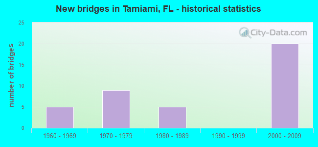
- New bridges - historical statistics
- 51960-1969
- 91970-1979
- 51980-1989
- 202000-2009

- Reconstructed bridges - Historical Statistics
- 31980-1989
- 11990-1999
- 12000-2009
- 02010-2019
- 22020-2022


- Bridge Condition - Deck
- 30.8%Very good
- 53.8%Good
- 15.4%Satisfactory

- Bridge Condition - Superstructure
- 38.5%Very good
- 53.8%Good
- 7.7%Satisfactory

- Bridge Condition - Substructure
- 42.3%Very good
- 50.0%Good
- 7.7%Satisfactory

- Bridge Condition - Channel
- 11.8%Excellent
- 5.9%Very good
- 64.7%Good
- 11.8%Satisfactory
- 5.9%Fair
Find on map >> Show street view
Structure Number: 10006, Location: 0.5MI S OF AIRPORT ROAD (Lat: 26.912722, Lng: -82.028944), Route carried "on" structure: Alternate County highway 765A, Year Built: 1960, Status: Open, Structure Length: 0.98m (3.22ft), Average Daily Traffic: 5,700 (year 2020), Truck Traffic: 3%, Average Future Daily Traffic: 9,890 (year 2042), Design Load: H 15, Features Intersected: N FORK ALLIGATOR CREEK
Minimum Vertical Clearance: 30+ m (98+ ft), Kilometerpoint: 5.135, Lanes on structure: 2, Owner: County Highway Agency, Approaching Roadway Width: 7.1m (23.3ft), Material/Design: Concrete, Design/Construction: Culvert, Number Of Spans In Main Unit: 3, Length of Maximum Span: 3.0m (9.8ft)
Condition: Channel: Good, Culverts: Good, Operating Rating: 68.9 metric tons, Method Used To Determine Operating Rating: Load Factor (LF), Inventory Rating: 41.3 metric tons, Method Used To Determine Inventory Rating: Load Factor (LF), Structural Evaluation: Better than present minimum criteria, Waterway Adequacy: Better than present minimum criteria, Approach Roadway Alignment: Equal to present desirable criteria, Designated Inspection Frequency: Every 24 months, Inspection Date: May 2021
Find on map >> Show street view
Structure Number: 10007, Location: 1.1MI E OF US-17 (Lat: 26.976239, Lng: -81.945861), Route carried "on" structure: County highway 764, Year Built: 1961, Status: Open, Structure Length: 4.57m (14.99ft), Average Daily Traffic: 2,071 (year 2021), Truck Traffic: 5%, Average Future Daily Traffic: 3,593 (year 2042), Design Load: H 15, Features Intersected: MYRTLE SLOUGH
Minimum Vertical Clearance: 30+ m (98+ ft), Kilometerpoint: 0.000, Lanes on structure: 2, Owner: County Highway Agency, Approaching Roadway Width: 5.8m (19.0ft), Material/Design: Concrete, Design/Construction: Slab, Number Of Spans In Main Unit: 5, Length of Maximum Span: 9.1m (29.9ft), Curb-To-Curb Width: 7.3m (24.0ft), Out-to-Out Width: 7.8m (25.6ft)
Condition: Deck: Satisfactory, Superstructure: Satisfactory, Substructure: Satisfactory, Channel: Good, Operating Rating: 38.1 metric tons, Method Used To Determine Operating Rating: Load Factor (LF), Inventory Rating: 22.9 metric tons, Method Used To Determine Inventory Rating: Load Factor (LF), Structural Evaluation: Equal to present minimum criteria, Deck Geometry: High priority of replacement, Waterway Adequacy: Better than present minimum criteria, Approach Roadway Alignment: Equal to present desirable criteria, Designated Inspection Frequency: Every 24 months, Underwater Inspection Frequency: Every 24 months, Inspection Date: May 2021, Underwater Inspection Date: April 2021, Deck Structure Type: Concrete Cast-file-Place
Find on map >> Show street view
Structure Number: 10008, Location: 4.9 MI E OF US-17 (Lat: 26.975369, Lng: -81.887478), Route carried "on" structure: County highway 764, Year Built: 1961, Status: Posted for load-capacity, Structure Length: 4.88m (16.01ft), Average Daily Traffic: 870 (year 2021), Truck Traffic: 5%, Average Future Daily Traffic: 1,509 (year 2042), Design Load: H 15, Features Intersected: SHELL CREEK
Minimum Vertical Clearance: 30+ m (98+ ft), Kilometerpoint: 0.000, Lanes on structure: 2, Owner: County Highway Agency, Approaching Roadway Width: 6.1m (20.0ft), Material/Design: Concrete, Design/Construction: Slab, Number Of Spans In Main Unit: 8, Length of Maximum Span: 6.1m (20.0ft), Curb or Sidewalk Widths: Left: 0.1m (0.3ft), Right: 0.1m (0.3ft), Curb-To-Curb Width: 7.4m (24.3ft), Out-to-Out Width: 7.9m (25.9ft)
Condition: Deck: Satisfactory, Superstructure: Satisfactory, Substructure: Good, Channel: Good, Operating Rating: 38.2 metric tons, Method Used To Determine Operating Rating: Load Factor (LF), Inventory Rating: 22.9 metric tons, Method Used To Determine Inventory Rating: Load Factor (LF), Structural Evaluation: Equal to present minimum criteria, Deck Geometry: Meets minimum limits, Waterway Adequacy: Equal to present desirable criteria, Approach Roadway Alignment: Better than present minimum criteria, Designated Inspection Frequency: Every 24 months, Underwater Inspection Frequency: Every 24 months, Inspection Date: May 2021, Underwater Inspection Date: April 2021, Deck Structure Type: Concrete Cast-file-Place
Find on map >> Show street view
Structure Number: 10042, Location: 1.7MI SOUTH OF SR-776 (Lat: 26.999281, Lng: -82.122281), Route carried "on" structure: US 41, Year Built: 1969, Year Reconstructed: 1994, Status: Open, Structure Length: 2.29m (7.51ft), Average Daily Traffic: 49,000 (year 2020), Truck Traffic: 5%, Average Future Daily Traffic: 85,015 (year 2042), Design Load: HS 20, Features Intersected: SUNSET CANAL
Minimum Vertical Clearance: 30+ m (98+ ft), Kilometerpoint: 32.419, Lanes on structure: 6, Base Highway Network: Yes, Owner: State Highway Agency, Approaching Roadway Width: 33.5m (109.9ft), Skew: 20 degrees, Material/Design: Concrete, Design/Construction: Slab, Number Of Spans In Main Unit: 3, Length of Maximum Span: 7.6m (24.9ft), Curb-To-Curb Width: 33.5m (109.9ft), Out-to-Out Width: 37.6m (123.4ft)
Condition: Deck: Good, Superstructure: Good, Substructure: Good, Channel: Good, Operating Rating: 62.1 metric tons, Method Used To Determine Operating Rating: Load Factor (LF), Inventory Rating: 37.2 metric tons, Method Used To Determine Inventory Rating: Load Factor (LF), Structural Evaluation: Better than present minimum criteria, Deck Geometry: Superior to present desirable criteria, Waterway Adequacy: Equal to present desirable criteria, Approach Roadway Alignment: Equal to present desirable criteria, Designated Inspection Frequency: Every 24 months, Underwater Inspection Frequency: Every 24 months, Inspection Date: May 2020, Underwater Inspection Date: April 2020, Deck Structure Type: Concrete Cast-file-Place
Find on map >> Show street view
Structure Number: 1005, Location: 0.3MI N OF US-17 (Lat: 26.944194, Lng: -82.058417), Route carried "on" structure: US 41, Year Built: 1976, Status: Open, Structure Length: 194.63m (638.55ft), Average Daily Traffic: 22,500 (year 2020), Truck Traffic: 7%, Average Future Daily Traffic: 39,038 (year 2042), Design Load: HS 20, Features Intersected: PEACE RIVER
Minimum Vertical Clearance: 30+ m (98+ ft), Kilometerpoint: 0.190, Lanes on structure: 2, Base Highway Network: Yes, Owner: State Highway Agency, Approaching Roadway Width: 8.9m (29.2ft), Navigation Control: Yes ( Vertical Clearance: 13.7m (44.9ft), Horizontal Clearance: 22.0m (72.2ft)), Material/Design: Prestressed concrete, Design/Construction: Stringer/Multi-beam, Number Of Spans In Main Unit: 85, Number Of Approach Spans: 6, Length of Maximum Span: 34.9m (114.5ft), Curb or Sidewalk Widths: Left: 1.5m (4.9ft), Right: 0.0m, Curb-To-Curb Width: 12.3m (40.4ft), Out-to-Out Width: 14.7m (48.2ft)
Condition: Deck: Satisfactory, Superstructure: Good, Substructure: Satisfactory, Channel: Good, Operating Rating: 62.5 metric tons, Method Used To Determine Operating Rating: Load Factor (LF), Inventory Rating: 37.2 metric tons, Method Used To Determine Inventory Rating: Load Factor (LF), Structural Evaluation: Equal to present minimum criteria, Deck Geometry: Better than present minimum criteria, Waterway Adequacy: Equal to present desirable criteria, Approach Roadway Alignment: Equal to present desirable criteria, Designated Inspection Frequency: Every 24 months, Underwater Inspection Frequency: Every 24 months, Inspection Date: July 2021, Underwater Inspection Date: June 2021, Deck Structure Type: Concrete Cast-file-Place
Find on map >> Show street view
Structure Number: 10102, Location: 4.8MI NORTH OF I-75 (Lat: 26.981081, Lng: -81.959097), Route carried "on" structure: US 17, Year Built: 2005, Status: Open, Structure Length: 4.54m (14.90ft), Average Daily Traffic: 6,250 (year 2020), Truck Traffic: 19%, Average Future Daily Traffic: 10,844 (year 2042), Design Load: HL 93, Features Intersected: SHELL CRK SOUTH SLOUGH
Minimum Vertical Clearance: 30.45m (99.90ft), Kilometerpoint: 1.128, Lanes on structure: 2, Base Highway Network: Yes, Owner: State Highway Agency, Approaching Roadway Width: 9.0m (29.5ft), Material/Design: Prestressed concrete, Design/Construction: Stringer/Multi-beam, Number Of Spans In Main Unit: 2, Length of Maximum Span: 22.7m (74.5ft), Curb or Sidewalk Widths: Left: 0.0m, Right: 1.5m (4.9ft), Curb-To-Curb Width: 11.0m (36.1ft), Out-to-Out Width: 13.7m (44.9ft)
Condition: Deck: Good, Superstructure: Very good, Substructure: Very good, Channel: Excellent, Inventory Rating: 56.8 metric tons, Method Used To Determine Inventory Rating: Load Factor (LF), Structural Evaluation: Equal to present desirable criteria, Deck Geometry: Equal to present minimum criteria, Waterway Adequacy: Equal to present desirable criteria, Approach Roadway Alignment: Equal to present desirable criteria, Designated Inspection Frequency: Every 24 months, Underwater Inspection Frequency: Every 24 months, Inspection Date: May 2020, Underwater Inspection Date: April 2020, Deck Structure Type: Concrete Cast-file-Place
Find on map >> Show street view
Structure Number: 10107, Location: 1.7MI NORTH OF I-75 (Lat: 26.953006, Lng: -81.995675), Route carried "on" structure: US 17, Year Built: 2002, Status: Open, Structure Length: 0.85m (2.79ft), Average Daily Traffic: 14,300 (year 2020), Truck Traffic: 18%, Average Future Daily Traffic: 24,810 (year 2042), Design Load: HS 20+Mod, Features Intersected: CLEVELAND CREEK
Minimum Vertical Clearance: 30+ m (98+ ft), Kilometerpoint: 6.251, Lanes on structure: 4, Base Highway Network: Yes, Owner: State Highway Agency, Approaching Roadway Width: 16.6m (54.5ft), Skew: 11 degrees, Material/Design: Concrete, Design/Construction: Culvert, Number Of Spans In Main Unit: 3, Length of Maximum Span: 2.7m (8.9ft)
Condition: Channel: Satisfactory, Culverts: Good, Inventory Rating: 65.6 metric tons, Method Used To Determine Inventory Rating: Load Factor (LF), Structural Evaluation: Better than present minimum criteria, Waterway Adequacy: Equal to present minimum criteria, Approach Roadway Alignment: Equal to present desirable criteria, Designated Inspection Frequency: Every 24 months, Inspection Date: June 2020
Find on map >> Show street view
Structure Number: 10046, Location: 0.1MI SOUTH OF SR-60 (Lat: 27.950442, Lng: -82.372219), Route carried "on" structure: State highway 618, Year Built: 1981, Status: Open, Structure Length: 48.57m (159.35ft), Average Daily Traffic: 32,750 (year 2021), Truck Traffic: 7%, Average Future Daily Traffic: 56,821 (year 2041), Design Load: HS 20+Mod, Features Intersected: CR-573 78TH ST & PALM R
Minimum Vertical Clearance: 30+ m (98+ ft), Kilometerpoint: 17.460, Lanes on structure: 2, Lanes under structure: 5, Base Highway Network: Yes, Toll: On toll road, Owner: State Toll Authority, Maintenance Responsibility: State Highway Agency, Approaching Roadway Width: 11.6m (38.1ft), Skew: 9 degrees, Navigation Control: Yes ( Vertical Clearance: 3.3m (10.8ft), Horizontal Clearance: 20.1m (65.9ft)), Material/Design: Prestressed concrete, Design/Construction: Stringer/Multi-beam, Number Of Spans In Main Unit: 24, Length of Maximum Span: 22.2m (72.8ft), Curb-To-Curb Width: 10.9m (35.8ft), Out-to-Out Width: 14.9m (48.9ft)
Condition: Deck: Satisfactory, Superstructure: Good, Substructure: Good, Channel: Good, Operating Rating: 50.2 metric tons, Method Used To Determine Operating Rating: Load Factor (LF), Inventory Rating: 30.0 metric tons, Method Used To Determine Inventory Rating: Load Factor (LF), Structural Evaluation: Better than present minimum criteria, Deck Geometry: Meets minimum limits, Underclear: Better than present minimum criteria, Waterway Adequacy: Equal to present desirable criteria, Approach Roadway Alignment: Equal to present desirable criteria, Designated Inspection Frequency: Every 24 months, Underwater Inspection Frequency: Every 24 months, Inspection Date: August 2021, Underwater Inspection Date: July 2021, Deck Structure Type: Concrete Cast-file-Place
Find on map >> Show street view
Structure Number: 10047, Location: 0.6MI NORTH OF SR-60 (Lat: 27.950189, Lng: -82.328386), Route carried "on" structure: Interstate 75, Year Built: 1983, Year Reconstructed: 2014, Status: Open, Structure Length: 4.53m (14.86ft), Average Daily Traffic: 70,750 (year 2021), Truck Traffic: 7%, Average Future Daily Traffic: 122,751 (year 2041), Design Load: HL 93, Features Intersected: CSX RR
Minimum Vertical Clearance: 30+ m (98+ ft), Kilometerpoint: 37.826, Lanes on structure: 3, Base Highway Network: Yes, Owner: State Highway Agency, Approaching Roadway Width: 17.1m (56.1ft), Material/Design: Prestressed concrete, Design/Construction: Stringer/Multi-beam, Number Of Spans In Main Unit: 3, Length of Maximum Span: 15.1m (49.5ft), Curb-To-Curb Width: 17.1m (56.1ft), Out-to-Out Width: 18.0m (59.1ft)
Condition: Deck: Good, Superstructure: Good, Substructure: Good, Operating Rating: 45.4 metric tons, Method Used To Determine Operating Rating: Load and Resistance Factor (LRFR), Inventory Rating: 41.2 metric tons, Method Used To Determine Inventory Rating: Load and Resistance Factor (LRFR), Structural Evaluation: Better than present minimum criteria, Deck Geometry: Equal to present minimum criteria, Underclear: Better than present minimum criteria, Approach Roadway Alignment: Equal to present desirable criteria, Designated Inspection Frequency: Every 24 months, Inspection Date: October 2021, Deck Structure Type: Concrete Cast-file-Place, Wearing Surface/Protective System: Wearing Surface: Monolithic Concrete
Find on map >> Show street view
Structure Number: 10048, Location: 0.3MI NORTH OF SR-582 (Lat: 28.058197, Lng: -82.354261), Route carried "on" structure: Ramp Interstate 75, Year Built: 1984, Status: Open, Structure Length: 10.40m (34.12ft), Average Daily Traffic: 4,600 (year 2020), Truck Traffic: 9%, Average Future Daily Traffic: 7,981 (year 2042), Design Load: HS 20+Mod, Features Intersected: COWHOUSE CREEK
Minimum Vertical Clearance: 30+ m (98+ ft), Kilometerpoint: 0.045, Lanes on structure: 1, Owner: State Highway Agency, Approaching Roadway Width: 8.4m (27.6ft), Material/Design: Prestressed concrete, Design/Construction: Stringer/Multi-beam, Number Of Spans In Main Unit: 4, Length of Maximum Span: 27.5m (90.2ft), Curb-To-Curb Width: 8.4m (27.6ft), Out-to-Out Width: 9.3m (30.5ft)
Condition: Deck: Good, Superstructure: Good, Substructure: Good, Channel: Very good, Operating Rating: 70.8 metric tons, Method Used To Determine Operating Rating: Allowable Stress (AS), Inventory Rating: 62.6 metric tons, Method Used To Determine Inventory Rating: Allowable Stress (AS), Structural Evaluation: Better than present minimum criteria, Deck Geometry: Superior to present desirable criteria, Waterway Adequacy: Superior to present desirable criteria, Approach Roadway Alignment: Equal to present desirable criteria, Designated Inspection Frequency: Every 24 months, Inspection Date: November 2021, Deck Structure Type: Concrete Cast-file-Place
Find on map >> Show street view
Structure Number: 10049, Location: 0.9MI E OF SR-43 US-301 (Lat: 27.928583, Lng: -82.337944), Route carried "on" structure: State highway 618, Year Built: 1985, Year Reconstructed: 2004, Status: Open, Structure Length: 6.75m (22.15ft), Average Daily Traffic: 29,500 (year 2021), Truck Traffic: 8%, Average Future Daily Traffic: 51,182 (year 2041), Design Load: HS 20, Features Intersected: FALKENBURG ROAD
Minimum Vertical Clearance: 30+ m (98+ ft), Kilometerpoint: 22.128, Lanes on structure: 4, Lanes under structure: 6, Base Highway Network: Yes, Toll: On toll road, Owner: State Toll Authority, Maintenance Responsibility: State Highway Agency, Approaching Roadway Width: 26.0m (85.3ft), Skew: 30 degrees, Material/Design: Prestressed concrete, Design/Construction: Stringer/Multi-beam, Number Of Spans In Main Unit: 2, Length of Maximum Span: 33.8m (110.9ft), Curb-To-Curb Width: 26.0m (85.3ft), Out-to-Out Width: 27.8m (91.2ft)
Condition: Deck: Good, Superstructure: Good, Substructure: Good, Operating Rating: 84.4 metric tons, Method Used To Determine Operating Rating: Load Factor (LF), Inventory Rating: 50.6 metric tons, Method Used To Determine Inventory Rating: Load Factor (LF), Structural Evaluation: Better than present minimum criteria, Deck Geometry: Superior to present desirable criteria, Underclear: Equal to present minimum criteria, Approach Roadway Alignment: Equal to present desirable criteria, Designated Inspection Frequency: Every 24 months, Inspection Date: August 2021, Deck Structure Type: Concrete Cast-file-Place
Find on map >> Show street view
Structure Number: 870212, Location: 12.9 MILES NORTH OF US-1 (Lat: 25.761106, Lng: -80.385525), Route carried "on" structure: State highway 821, Year Built: 1973, Year Reconstructed: 2020, Status: Open, Structure Length: 8.96m (29.40ft), Average Daily Traffic: 202,300 (year 2021), Truck Traffic: 8%, Average Future Daily Traffic: 237,400 (year 2042), Design Load: HS 20+Mod, Features Intersected: US 41-SW 8 ST-TAMIAMI CA
Minimum Vertical Clearance: 30+ m (98+ ft), Kilometerpoint: 41.415, Lanes on structure: 7, Lanes under structure: 7, Base Highway Network: Yes, Toll: On toll road, Owner: State Toll Authority, Approaching Roadway Width: 34.4m (112.9ft), Material/Design: Prestressed concrete, Design/Construction: Stringer/Multi-beam, Number Of Spans In Main Unit: 5, Length of Maximum Span: 21.6m (70.9ft), Curb-To-Curb Width: 34.4m (112.9ft), Out-to-Out Width: 34.9m (114.5ft)
Condition: Deck: Good, Superstructure: Good, Substructure: Good, Channel: Good, Operating Rating: 52.6 metric tons, Method Used To Determine Operating Rating: Load and Resistance Factor (LRFR), Inventory Rating: 39.8 metric tons, Method Used To Determine Inventory Rating: Load and Resistance Factor (LRFR), Structural Evaluation: Better than present minimum criteria, Deck Geometry: Superior to present desirable criteria, Underclear: Somewhat better than minimum adequacy, Waterway Adequacy: Equal to present desirable criteria, Approach Roadway Alignment: Equal to present desirable criteria, Designated Inspection Frequency: Every 9 months, Underwater Inspection Frequency: Every 9 months, Inspection Date: July 2021, Underwater Inspection Date: July 2021, Deck Structure Type: Concrete Cast-file-Place
Find on map >> Show street view
Structure Number: 870213, Location: 12.5 MILES NORTH OF US-1 (Lat: 25.757633, Lng: -80.384606), Route carried "on" structure: Ramp State highway 821, Year Built: 1974, Status: Open, Structure Length: 3.75m (12.30ft), Average Daily Traffic: 6,100 (year 2021), Truck Traffic: 8%, Average Future Daily Traffic: 10,584 (year 2042), Design Load: HS 20+Mod, Features Intersected: SNAPPER CREEK CANAL C-2
Minimum Vertical Clearance: 30+ m (98+ ft), Kilometerpoint: 0.105, Lanes on structure: 1, Toll: On toll road, Owner: State Toll Authority, Approaching Roadway Width: 6.5m (21.3ft), Skew: 4 degrees, Material/Design: Prestressed concrete, Design/Construction: Stringer/Multi-beam, Number Of Spans In Main Unit: 3, Length of Maximum Span: 14.0m (45.9ft), Curb-To-Curb Width: 7.6m (24.9ft), Out-to-Out Width: 8.6m (28.2ft)
Condition: Deck: Good, Superstructure: Good, Substructure: Good, Channel: Good, Operating Rating: 58.0 metric tons, Method Used To Determine Operating Rating: Load Factor (LF), Inventory Rating: 34.7 metric tons, Method Used To Determine Inventory Rating: Load Factor (LF), Structural Evaluation: Better than present minimum criteria, Deck Geometry: Better than present minimum criteria, Waterway Adequacy: Better than present minimum criteria, Approach Roadway Alignment: Equal to present desirable criteria, Designated Inspection Frequency: Every 24 months, Underwater Inspection Frequency: Every 24 months, Other Special Inspection Frequency: Every 9 months, Inspection Date: April 2020, Underwater Inspection Date: April 2020, Other Special Inspection Date: July 2021, Deck Structure Type: Concrete Cast-file-Place
Find on map >> Show street view
Structure Number: 870415, Location: 12.9 MILES NORTH OF US-1 (Lat: 25.761106, Lng: -80.385239), Route carried "on" structure: State highway 821, Year Built: 1973, Year Reconstructed: 2020, Status: Open, Structure Length: 8.96m (29.40ft), Average Daily Traffic: 202,300 (year 2021), Truck Traffic: 8%, Average Future Daily Traffic: 237,400 (year 2042), Design Load: HS 20+Mod, Features Intersected: US 41-SW 8 ST-TAMIAMI CA
Minimum Vertical Clearance: 30+ m (98+ ft), Kilometerpoint: 41.415, Lanes on structure: 7, Lanes under structure: 7, Base Highway Network: Yes, Toll: On toll road, Owner: State Toll Authority, Approaching Roadway Width: 33.8m (110.9ft), Material/Design: Prestressed concrete, Design/Construction: Stringer/Multi-beam, Number Of Spans In Main Unit: 5, Length of Maximum Span: 21.6m (70.9ft), Curb-To-Curb Width: 33.8m (110.9ft), Out-to-Out Width: 34.9m (114.5ft)
Condition: Deck: Good, Superstructure: Good, Substructure: Good, Channel: Good, Operating Rating: 51.0 metric tons, Method Used To Determine Operating Rating: Load and Resistance Factor (LRFR), Inventory Rating: 34.7 metric tons, Method Used To Determine Inventory Rating: Load and Resistance Factor (LRFR), Structural Evaluation: Better than present minimum criteria, Deck Geometry: Superior to present desirable criteria, Underclear: Somewhat better than minimum adequacy, Waterway Adequacy: Equal to present desirable criteria, Approach Roadway Alignment: Equal to present desirable criteria, Designated Inspection Frequency: Every 9 months, Underwater Inspection Frequency: Every 9 months, Inspection Date: July 2021, Underwater Inspection Date: July 2021, Deck Structure Type: Concrete Cast-file-Place
Find on map >> Show street view
Structure Number: 870516, Location: 0.1 MI S OF SW 8TH ST (Lat: 25.759492, Lng: -80.384708), Route carried "on" structure: Ramp State highway 821, Year Built: 1977, Year Reconstructed: 1992, Status: Open, Structure Length: 4.72m (15.49ft), Average Daily Traffic: 14,250 (year 2020), Truck Traffic: 8%, Average Future Daily Traffic: 24,724 (year 2042), Design Load: HS 20+Mod, Features Intersected: SNAPPER CREEK CANAL C-2
Minimum Vertical Clearance: 30+ m (98+ ft), Kilometerpoint: 0.351, Lanes on structure: 2, Toll: On toll road, Owner: State Toll Authority, Approaching Roadway Width: 13.1m (43.0ft), Skew: 4 degrees, Material/Design: Prestressed concrete, Design/Construction: Stringer/Multi-beam, Number Of Spans In Main Unit: 3, Length of Maximum Span: 16.5m (54.1ft), Curb-To-Curb Width: 13.1m (43.0ft), Out-to-Out Width: 14.1m (46.3ft)
Condition: Deck: Good, Superstructure: Very good, Substructure: Good, Channel: Good, Operating Rating: 52.9 metric tons, Method Used To Determine Operating Rating: Load and Resistance Factor (LRFR), Inventory Rating: 40.2 metric tons, Method Used To Determine Inventory Rating: Load and Resistance Factor (LRFR), Structural Evaluation: Better than present minimum criteria, Deck Geometry: Superior to present desirable criteria, Waterway Adequacy: Better than present minimum criteria, Approach Roadway Alignment: Equal to present desirable criteria, Designated Inspection Frequency: Every 24 months, Underwater Inspection Frequency: Every 24 months, Inspection Date: April 2020, Underwater Inspection Date: April 2020, Deck Structure Type: Concrete Cast-file-Place
Find on map >> Show street view
Structure Number: 870963, Location: E. OF SW 132 AVE. (Lat: 25.760967, Lng: -80.408781), Route carried "on" structure: State highway SR-90, Year Built: 2004, Status: Open, Structure Length: 2.24m (7.35ft), Average Daily Traffic: 37,500 (year 2020), Truck Traffic: 7%, Average Future Daily Traffic: 65,062 (year 2042), Design Load: HL 93, Features Intersected: CANAL (SW 132 AVE), Facility Carried by Structure: SR 90 (US 41)
Minimum Vertical Clearance: 30+ m (98+ ft), Kilometerpoint: 7.287, Lanes on structure: 9, Owner: State Highway Agency, Approaching Roadway Width: 36.1m (118.4ft), Skew: 20 degrees, Material/Design: Concrete, Design/Construction: Slab, Number Of Spans In Main Unit: 3, Length of Maximum Span: 8.6m (28.2ft), Curb or Sidewalk Widths: Left: 0.0m, Right: 1.9m (6.2ft), Curb-To-Curb Width: 36.1m (118.4ft), Out-to-Out Width: 40.2m (131.9ft)
Condition: Deck: Very good, Superstructure: Very good, Substructure: Very good, Channel: Excellent, Operating Rating: 63.6 metric tons, Method Used To Determine Operating Rating: Load and Resistance Factor (LRFR), Inventory Rating: 49.1 metric tons, Method Used To Determine Inventory Rating: Load and Resistance Factor (LRFR), Structural Evaluation: Equal to present desirable criteria, Deck Geometry: Somewhat better than minimum adequacy, Waterway Adequacy: Better than present minimum criteria, Approach Roadway Alignment: Equal to present desirable criteria, Designated Inspection Frequency: Every 24 months, Underwater Inspection Frequency: Every 24 months, Inspection Date: September 2020, Underwater Inspection Date: September 2020, Deck Structure Type: Concrete Cast-file-Place, Wearing Surface/Protective System: Wearing Surface: Monolithic Concrete
Find on map >> Show street view
Structure Number: 870998, Location: SR 836 / HEFT Intchg. (Lat: 25.776264, Lng: -80.385944), Route carried "on" structure: Ramp State highway 836, Year Built: 2005, Status: Open, Structure Length: 16.55m (54.30ft), Average Daily Traffic: 40,250 (year 2020), Truck Traffic: 3%, Average Future Daily Traffic: 69,834 (year 2042), Design Load: HS 20+Mod, Features Intersected: NB/SB H.E.F.T (Turnpike)
Minimum Vertical Clearance: 30+ m (98+ ft), Kilometerpoint: 4.408, Lanes on structure: 3, Lanes under structure: 7, Base Highway Network: Yes, Toll: On toll road, Owner: State Toll Authority, Approaching Roadway Width: 18.3m (60.0ft), Skew: 3 degrees, Material/Design: Steel continuous, Design/Construction: Box Beam or Girders - Single/Spread, Number Of Spans In Main Unit: 3, Length of Maximum Span: 75.9m (249.0ft), Curb-To-Curb Width: 18.3m (60.0ft), Out-to-Out Width: 19.2m (63.0ft)
Condition: Deck: Very good, Superstructure: Very good, Substructure: Very good, Operating Rating: 63.0 metric tons, Method Used To Determine Operating Rating: Load and Resistance Factor (LRFR), Inventory Rating: 48.6 metric tons, Method Used To Determine Inventory Rating: Load and Resistance Factor (LRFR), Structural Evaluation: Equal to present desirable criteria, Deck Geometry: Superior to present desirable criteria, Underclear: High priority of corrective action, Approach Roadway Alignment: Better than present minimum criteria, Designated Inspection Frequency: Every 24 months, Inspection Date: December 2020, Deck Structure Type: Concrete Cast-file-Place
Find on map >> Show street view
Structure Number: 871003, Location: 0.2 mile West of H.E.F.T. (Lat: 25.782639, Lng: -80.391667), Route carried "on" structure: State highway 836, Year Built: 2006, Status: Open, Structure Length: 33.49m (109.88ft), Average Daily Traffic: 26,800 (year 2020), Average Future Daily Traffic: 73,900 (year 2042), Design Load: HS 20, Features Intersected: NW 12th Street
Minimum Vertical Clearance: 30.45m (99.90ft), Kilometerpoint: 3.425, Lanes on structure: 2, Lanes under structure: 5, Base Highway Network: Yes, Toll: On toll road, Owner: State Toll Authority, Approaching Roadway Width: 18.0m (59.1ft), Material/Design: Steel, Design/Construction: Box Beam or Girders - Single/Spread, Number Of Spans In Main Unit: 5, Length of Maximum Span: 89.2m (292.7ft), Curb-To-Curb Width: 18.0m (59.1ft), Out-to-Out Width: 18.9m (62.0ft)
Condition: Deck: Very good, Superstructure: Very good, Substructure: Very good, Operating Rating: 53.9 metric tons, Method Used To Determine Operating Rating: Load and Resistance Factor (LRFR), Inventory Rating: 41.5 metric tons, Method Used To Determine Inventory Rating: Load and Resistance Factor (LRFR), Structural Evaluation: Equal to present desirable criteria, Deck Geometry: Superior to present desirable criteria, Underclear: Superior to present desirable criteria, Approach Roadway Alignment: Equal to present desirable criteria, Designated Inspection Frequency: Every 24 months, Critical Feature Inspection Frequency: Every 24 months, Inspection Date: December 2020, Critical Feature Inspection Date: December 2020, Deck Structure Type: Concrete Cast-file-Place, Wearing Surface/Protective System: Wearing Surface: Monolithic Concrete
Find on map >> Show street view
Structure Number: 871004, Location: 0.2 mi. West of Turnpike (Lat: 25.782639, Lng: -80.392222), Route carried "on" structure: State highway 836, Year Built: 2006, Status: Open, Structure Length: 32.25m (105.81ft), Average Daily Traffic: 37,200 (year 2020), Average Future Daily Traffic: 102,600 (year 2042), Design Load: HS 25 or greater, Features Intersected: NW 12th Street
Minimum Vertical Clearance: 8.63m (28.31ft), Kilometerpoint: 3.368, Lanes on structure: 2, Lanes under structure: 4, Base Highway Network: Yes, Toll: On toll road, Owner: State Toll Authority, Approaching Roadway Width: 18.0m (59.1ft), Material/Design: Steel, Design/Construction: Box Beam or Girders - Single/Spread, Number Of Spans In Main Unit: 5, Length of Maximum Span: 84.0m (275.6ft), Curb-To-Curb Width: 18.0m (59.1ft), Out-to-Out Width: 19.0m (62.3ft)
Condition: Deck: Very good, Superstructure: Very good, Substructure: Very good, Operating Rating: 70.6 metric tons, Method Used To Determine Operating Rating: Load and Resistance Factor (LRFR), Inventory Rating: 54.4 metric tons, Method Used To Determine Inventory Rating: Load and Resistance Factor (LRFR), Structural Evaluation: Equal to present desirable criteria, Deck Geometry: Superior to present desirable criteria, Underclear: Equal to present minimum criteria, Approach Roadway Alignment: Equal to present desirable criteria, Designated Inspection Frequency: Every 24 months, Critical Feature Inspection Frequency: Every 24 months, Inspection Date: December 2020, Critical Feature Inspection Date: December 2020, Deck Structure Type: Concrete Cast-file-Place, Wearing Surface/Protective System: Wearing Surface: Monolithic Concrete
Find on map >> Show street view
Structure Number: 871006, Location: At NW 137th Ave Off Ramp (Lat: 25.779000, Lng: -80.419569), Route carried "on" structure: Ramp State highway 836, Year Built: 2006, Status: Open, Structure Length: 2.99m (9.81ft), Average Daily Traffic: 26,198 (year 2020), Truck Traffic: 3%, Average Future Daily Traffic: 58,181 (year 2042), Design Load: HL 93, Features Intersected: Access Road No. 2
Minimum Vertical Clearance: 30+ m (98+ ft), Kilometerpoint: 0.407, Lanes on structure: 2, Lanes under structure: 4, Base Highway Network: Yes, Toll: On toll road, Owner: State Toll Authority, Approaching Roadway Width: 12.7m (41.7ft), Material/Design: Prestressed concrete, Design/Construction: Box Beam or Girders - Single/Spread, Number Of Spans In Main Unit: 1, Length of Maximum Span: 29.9m (98.1ft), Curb-To-Curb Width: 13.3m (43.6ft), Out-to-Out Width: 14.2m (46.6ft)
Condition: Deck: Very good, Superstructure: Very good, Substructure: Very good, Operating Rating: 45.4 metric tons, Method Used To Determine Operating Rating: Load and Resistance Factor (LRFR), Inventory Rating: 39.2 metric tons, Method Used To Determine Inventory Rating: Load and Resistance Factor (LRFR), Structural Evaluation: Equal to present desirable criteria, Deck Geometry: Superior to present desirable criteria, Approach Roadway Alignment: Equal to present minimum criteria, Designated Inspection Frequency: Every 24 months, Inspection Date: September 2020, Deck Structure Type: Concrete Cast-file-Place, Wearing Surface/Protective System: Wearing Surface: Other
Find on map >> Show street view
Structure Number: 871007, Location: 0.16 mi. E/O NW 137th AVE (Lat: 25.782608, Lng: -80.415636), Route carried "on" structure: Ramp State highway 836, Year Built: 2006, Status: Open, Structure Length: 13.85m (45.44ft), Average Daily Traffic: 34,600 (year 2020), Average Future Daily Traffic: 95,300 (year 2042), Design Load: HS 20, Features Intersected: NW 12th St
Minimum Vertical Clearance: 30+ m (98+ ft), Kilometerpoint: 0.987, Lanes on structure: 2, Lanes under structure: 4, Toll: On toll road, Owner: State Toll Authority, Approaching Roadway Width: 12.8m (42.0ft), Material/Design: Steel, Design/Construction: Box Beam or Girders - Single/Spread, Number Of Spans In Main Unit: 3, Length of Maximum Span: 56.8m (186.4ft), Curb-To-Curb Width: 12.8m (42.0ft), Out-to-Out Width: 13.7m (44.9ft)
Condition: Deck: Very good, Superstructure: Very good, Substructure: Very good, Operating Rating: 48.4 metric tons, Method Used To Determine Operating Rating: Load and Resistance Factor (LRFR), Inventory Rating: 37.2 metric tons, Method Used To Determine Inventory Rating: Load and Resistance Factor (LRFR), Structural Evaluation: Equal to present desirable criteria, Deck Geometry: Superior to present desirable criteria, Underclear: High priority of corrective action, Approach Roadway Alignment: Equal to present minimum criteria, Designated Inspection Frequency: Every 24 months, Critical Feature Inspection Frequency: Every 24 months, Inspection Date: December 2020, Critical Feature Inspection Date: December 2020, Deck Structure Type: Concrete Cast-file-Place, Wearing Surface/Protective System: Wearing Surface: Monolithic Concrete
Find on map >> Show street view
Structure Number: 871008, Location: 0.10 mi. E/O NW 137th Ave (Lat: 25.782250, Lng: -80.416528), Route carried "on" structure: Ramp State highway 836, Year Built: 2006, Status: Open, Structure Length: 22.08m (72.44ft), Average Daily Traffic: 2,700 (year 2020), Average Future Daily Traffic: 7,400 (year 2042), Design Load: HS 25 or greater, Features Intersected: NW 12 St, 137 Av, & CSX
Minimum Vertical Clearance: 30+ m (98+ ft), Kilometerpoint: 0.882, Lanes on structure: 1, Lanes under structure: 10, Toll: On toll road, Owner: State Toll Authority, Approaching Roadway Width: 8.2m (26.9ft), Material/Design: Steel, Design/Construction: Box Beam or Girders - Single/Spread, Number Of Spans In Main Unit: 4, Length of Maximum Span: 61.0m (200.1ft), Curb-To-Curb Width: 8.2m (26.9ft), Out-to-Out Width: 9.1m (29.9ft)
Condition: Deck: Very good, Superstructure: Very good, Substructure: Very good, Operating Rating: 55.5 metric tons, Method Used To Determine Operating Rating: Load and Resistance Factor (LRFR), Inventory Rating: 42.8 metric tons, Method Used To Determine Inventory Rating: Load and Resistance Factor (LRFR), Structural Evaluation: Equal to present desirable criteria, Deck Geometry: Superior to present desirable criteria, Underclear: Somewhat better than minimum adequacy, Approach Roadway Alignment: Equal to present minimum criteria, Designated Inspection Frequency: Every 24 months, Critical Feature Inspection Frequency: Every 24 months, Inspection Date: December 2020, Critical Feature Inspection Date: December 2020, Deck Structure Type: Concrete Cast-file-Place, Wearing Surface/Protective System: Wearing Surface: Monolithic Concrete
Find on map >> Show street view
Structure Number: 871009, Location: NW 137th Ave Off Ramp (Lat: 25.782375, Lng: -80.416622), Route carried "on" structure: Ramp State highway 836, Year Built: 2006, Status: Open, Structure Length: 19.66m (64.50ft), Average Daily Traffic: 26,800 (year 2020), Average Future Daily Traffic: 73,900 (year 2042), Design Load: HS 25 or greater, Features Intersected: NW 12 St, 137 Av, & CSX
Minimum Vertical Clearance: 30+ m (98+ ft), Kilometerpoint: 0.877, Lanes on structure: 3, Lanes under structure: 11, Base Highway Network: Yes, Toll: On toll road, Owner: State Toll Authority, Approaching Roadway Width: 18.3m (60.0ft), Material/Design: Steel, Design/Construction: Box Beam or Girders - Single/Spread, Number Of Spans In Main Unit: 3, Length of Maximum Span: 69.5m (228.0ft), Curb-To-Curb Width: 18.3m (60.0ft), Out-to-Out Width: 19.2m (63.0ft)
Condition: Deck: Very good, Superstructure: Very good, Substructure: Very good, Operating Rating: 50.0 metric tons, Method Used To Determine Operating Rating: Load and Resistance Factor (LRFR), Inventory Rating: 38.6 metric tons, Method Used To Determine Inventory Rating: Load and Resistance Factor (LRFR), Structural Evaluation: Equal to present desirable criteria, Deck Geometry: Superior to present desirable criteria, Underclear: Equal to present minimum criteria, Approach Roadway Alignment: Equal to present minimum criteria, Designated Inspection Frequency: Every 24 months, Critical Feature Inspection Frequency: Every 24 months, Inspection Date: December 2020, Critical Feature Inspection Date: December 2020, Deck Structure Type: Concrete Cast-file-Place, Wearing Surface/Protective System: Wearing Surface: Monolithic Concrete
Find on map >> Show street view
Structure Number: 874215, Location: At US-41 (SW 8th St.) (Lat: 25.762078, Lng: -80.348275), Route carried "on" structure: City street , Year Built: 1965, Status: Open, Structure Length: 2.26m (7.41ft), Average Daily Traffic: 15,350 (year 2020), Truck Traffic: 5%, Average Future Daily Traffic: 26,700 (year 2042), Design Load: HS 20, Features Intersected: Tamiami Canal C-4, Facility Carried by Structure: SW 94th Avenue
Minimum Vertical Clearance: 30+ m (98+ ft), Kilometerpoint: 0.029, Lanes on structure: 3, Owner: County Highway Agency, Approaching Roadway Width: 12.8m (42.0ft), Skew: 22 degrees, Material/Design: Concrete, Design/Construction: Slab, Number Of Spans In Main Unit: 3, Length of Maximum Span: 9.1m (29.9ft), Curb or Sidewalk Widths: Left: 1.5m (4.9ft), Right: 1.5m (4.9ft), Curb-To-Curb Width: 12.8m (42.0ft), Out-to-Out Width: 17.1m (56.1ft)
Condition: Deck: Good, Superstructure: Good, Substructure: Good, Channel: Good, Operating Rating: 60.3 metric tons, Method Used To Determine Operating Rating: Load Factor (LF), Inventory Rating: 41.1 metric tons, Method Used To Determine Inventory Rating: Load Factor (LF), Structural Evaluation: Better than present minimum criteria, Deck Geometry: Meets minimum limits, Waterway Adequacy: Better than present minimum criteria, Approach Roadway Alignment: Somewhat better than minimum adequacy, Designated Inspection Frequency: Every 24 months, Underwater Inspection Frequency: Every 24 months, Inspection Date: October 2021, Underwater Inspection Date: October 2021, Deck Structure Type: Concrete Precast Panels, Wearing Surface/Protective System: Wearing Surface: Bituminous
Find on map >> Show street view
Structure Number: 874216, Location: North Side of US 41 (Lat: 25.761972, Lng: -80.352417), Route carried "on" structure: County highway , Year Built: 1981, Year Reconstructed: 1994, Status: Open, Structure Length: 2.29m (7.51ft), Average Daily Traffic: 16,900 (year 2021), Truck Traffic: 5%, Average Future Daily Traffic: 29,860 (year 2042), Design Load: HS 20, Features Intersected: Tamiami Canal C-4, Facility Carried by Structure: SW 97th Avenue
Minimum Vertical Clearance: 30+ m (98+ ft), Kilometerpoint: 0.031, Lanes on structure: 5, Owner: County Highway Agency, Approaching Roadway Width: 18.0m (59.1ft), Material/Design: Prestressed concrete, Design/Construction: Slab, Number Of Spans In Main Unit: 3, Length of Maximum Span: 9.1m (29.9ft), Curb or Sidewalk Widths: Left: 1.6m (5.2ft), Right: 1.5m (4.9ft), Curb-To-Curb Width: 18.0m (59.1ft), Out-to-Out Width: 22.8m (74.8ft)
Condition: Deck: Good, Superstructure: Good, Substructure: Good, Channel: Fair, Operating Rating: 49.7 metric tons, Method Used To Determine Operating Rating: Load Factor (LF), Inventory Rating: 29.8 metric tons, Method Used To Determine Inventory Rating: Load Factor (LF), Structural Evaluation: Better than present minimum criteria, Deck Geometry: High priority of replacement, Waterway Adequacy: Better than present minimum criteria, Approach Roadway Alignment: Equal to present minimum criteria, Designated Inspection Frequency: Every 24 months, Underwater Inspection Frequency: Every 24 months, Inspection Date: November 2021, Underwater Inspection Date: January 2021, Deck Structure Type: Concrete Precast Panels, Wearing Surface/Protective System: Wearing Surface: Bituminous
Find on map >> Show street view
Structure Number: 874246, Location: At US-41(SW 8th St.) (Lat: 25.761378, Lng: -80.409833), Route carried "on" structure: County highway , Year Built: 2004, Status: Open, Structure Length: 2.50m (8.20ft), Average Daily Traffic: 13,457 (year 2020), Truck Traffic: 5%, Average Future Daily Traffic: 20,050 (year 2042), Design Load: HS 25 or greater, Features Intersected: C-4 Canal, Facility Carried by Structure: SW 132nd Ave.
Minimum Vertical Clearance: 30+ m (98+ ft), Kilometerpoint: 1.963, Lanes on structure: 8, Owner: County Highway Agency, Approaching Roadway Width: 11.3m (37.1ft), Skew: 20 degrees, Material/Design: Concrete, Design/Construction: Slab, Number Of Spans In Main Unit: 3, Length of Maximum Span: 9.0m (29.5ft), Curb or Sidewalk Widths: Left: 1.8m (5.9ft), Right: 1.8m (5.9ft), Curb-To-Curb Width: 29.6m (97.1ft), Out-to-Out Width: 35.8m (117.5ft)
Condition: Deck: Good, Superstructure: Good, Substructure: Good, Channel: Satisfactory, Inventory Rating: 73.1 metric tons, Method Used To Determine Inventory Rating: Load Factor (LF), Structural Evaluation: Better than present minimum criteria, Deck Geometry: Meets minimum limits, Waterway Adequacy: Equal to present minimum criteria, Approach Roadway Alignment: Equal to present desirable criteria, Designated Inspection Frequency: Every 24 months, Underwater Inspection Frequency: Every 24 months, Inspection Date: June 2020, Underwater Inspection Date: June 2020, Deck Structure Type: Concrete Cast-file-Place
Find on map >> Show street view
Structure Number: 874637, Location: 0.8Mile E of NW 107th Ave (Lat: 25.776050, Lng: -80.357256), Route carried "on" structure: City street , Year Built: 1970, Status: Open, Structure Length: 1.04m (3.41ft), Average Daily Traffic: 9,109 (year 2014), Truck Traffic: 5%, Average Future Daily Traffic: 15,042 (year 2039), Design Load: HS 20, Features Intersected: Golf Cart Path, Facility Carried by Structure: Fountainbl Blvd WB
Minimum Vertical Clearance: 30+ m (98+ ft), Kilometerpoint: 2.842, Lanes on structure: 2, Owner: County Highway Agency, Approaching Roadway Width: 8.6m (28.2ft), Material/Design: Prestressed concrete, Design/Construction: Slab, Number Of Spans In Main Unit: 1, Length of Maximum Span: 10.4m (34.1ft), Curb or Sidewalk Widths: Left: 1.7m (5.6ft), Right: 0.0m, Curb-To-Curb Width: 8.6m (28.2ft), Out-to-Out Width: 11.2m (36.7ft)
Condition: Deck: Good, Superstructure: Good, Substructure: Very good, Operating Rating: 59.5 metric tons, Method Used To Determine Operating Rating: Load Factor (LF), Inventory Rating: 35.7 metric tons, Method Used To Determine Inventory Rating: Load Factor (LF), Structural Evaluation: Better than present minimum criteria, Deck Geometry: High priority of corrective action, Approach Roadway Alignment: Equal to present desirable criteria, Designated Inspection Frequency: Every 24 months, Inspection Date: April 2020, Deck Structure Type: Concrete Precast Panels
Find on map >> Show street view
Structure Number: 874638, Location: 0.8 Mile E of NW 107th Av (Lat: 25.775867, Lng: -80.357325), Route carried "on" structure: City street , Year Built: 1970, Status: Open, Structure Length: 1.04m (3.41ft), Average Daily Traffic: 9,109 (year 2014), Truck Traffic: 5%, Average Future Daily Traffic: 15,042 (year 2039), Design Load: HS 20, Features Intersected: Golf Cart Path, Facility Carried by Structure: Fountainbl Blvd EB
Minimum Vertical Clearance: 30+ m (98+ ft), Kilometerpoint: 2.842, Lanes on structure: 2, Owner: County Highway Agency, Approaching Roadway Width: 7.0m (23.0ft), Material/Design: Prestressed concrete, Design/Construction: Slab, Number Of Spans In Main Unit: 1, Length of Maximum Span: 10.4m (34.1ft), Curb or Sidewalk Widths: Left: 0.0m, Right: 1.7m (5.6ft), Curb-To-Curb Width: 8.6m (28.2ft), Out-to-Out Width: 11.2m (36.7ft)
Condition: Deck: Good, Superstructure: Good, Substructure: Very good, Operating Rating: 59.5 metric tons, Method Used To Determine Operating Rating: Load Factor (LF), Inventory Rating: 35.7 metric tons, Method Used To Determine Inventory Rating: Load Factor (LF), Structural Evaluation: Better than present minimum criteria, Deck Geometry: High priority of corrective action, Approach Roadway Alignment: Equal to present desirable criteria, Designated Inspection Frequency: Every 24 months, Inspection Date: April 2020, Deck Structure Type: Concrete Precast Panels, Wearing Surface/Protective System: Wearing Surface: Monolithic Concrete
Find on map >> Show street view
Structure Number: 870212, Location: 12.9 MILES NORTH OF US-1 (Lat: 25.761106, Lng: -80.385525), Route carried "under" structure: US 41, Year Built: 1973, Structure Length: 0. m, Average Daily Traffic: 63,900 (year 2021), Truck Traffic: 7%, Features Intersected: US 41-SW 8 ST-TAMIAMI CA, Facility Carried by Structure: SR821 SB HEFT 25.6
Minimum Vertical Clearance: 5.03m (16.50ft), Kilometerpoint: 9.611, Lanes on structure: 7, Lanes under structure: 7, Material/Design: Prestressed concrete, Design/Construction: Stringer/Multi-beam, Length of Maximum Span: 21.6m (70.9ft)
Find on map >> Show street view
Structure Number: 870415, Location: 12.9 MILES NORTH OF US-1 (Lat: 25.761106, Lng: -80.385239), Route carried "under" structure: US 41, Year Built: 1973, Structure Length: 0. m, Average Daily Traffic: 63,900 (year 2021), Truck Traffic: 7%, Features Intersected: US 41-SW 8 ST-TAMIAMI CA, Facility Carried by Structure: SR821 NB HEFT 25.6
Minimum Vertical Clearance: 5.03m (16.50ft), Kilometerpoint: 9.638, Lanes on structure: 7, Lanes under structure: 7, Material/Design: Prestressed concrete, Design/Construction: Stringer/Multi-beam, Length of Maximum Span: 21.6m (70.9ft)
Find on map >> Show street view
Structure Number: 870998, Location: SR 836 / HEFT Intchg. (Lat: 25.776264, Lng: -80.385944), Route carried "under" structure: US 821, Year Built: 2005, Structure Length: 0. m, Average Daily Traffic: 99 (year 2020), Features Intersected: NB/SB H.E.F.T (Turnpike), Facility Carried by Structure: WB SR 836 Off Ramp
Minimum Vertical Clearance: 7.62m (25.00ft), Kilometerpoint: 42.648, Lanes on structure: 3, Lanes under structure: 7, Toll: On toll road, Material/Design: Steel continuous, Design/Construction: Box Beam or Girders - Single/Spread, Length of Maximum Span: 75.9m (249.0ft)
Find on map >> Show street view
Structure Number: 871003, Location: 0.2 mile West of H.E.F.T. (Lat: 25.782639, Lng: -80.391667), Route carried "under" structure: City street , Year Built: 2006, Structure Length: 0. m, Average Daily Traffic: 4,500 (year 2020), Features Intersected: NW 12th Street, Facility Carried by Structure: SR 836 WB
Minimum Vertical Clearance: 8.53m (27.99ft), Kilometerpoint: 3.425, Lanes on structure: 2, Lanes under structure: 5, Material/Design: Steel, Design/Construction: Box Beam or Girders - Single/Spread, Length of Maximum Span: 89.2m (292.7ft)
Find on map >> Show street view
Structure Number: 871004, Location: 0.2 mi. West of Turnpike (Lat: 25.782639, Lng: -80.392222), Route carried "under" structure: City street , Year Built: 2006, Structure Length: 0. m, Average Daily Traffic: 4,500 (year 2020), Features Intersected: NW 12th Street, Facility Carried by Structure: SR 836 EB
Minimum Vertical Clearance: 7.96m (26.12ft), Kilometerpoint: 3.425, Lanes on structure: 2, Lanes under structure: 4, Material/Design: Steel, Design/Construction: Box Beam or Girders - Single/Spread, Length of Maximum Span: 84.0m (275.6ft)
Find on map >> Show street view
Structure Number: 871006, Location: At NW 137th Ave Off Ramp (Lat: 25.779000, Lng: -80.419569), Route carried "under" structure: ServiceOther road 836, Year Built: 2006, Structure Length: 0. m, Features Intersected: Access Road No. 2
Minimum Vertical Clearance: 5.24m (17.19ft), Kilometerpoint: 0.000, Lanes on structure: 2, Lanes under structure: 2, Toll: On toll road, Material/Design: Prestressed concrete, Design/Construction: Box Beam or Girders - Single/Spread, Length of Maximum Span: 29.9m (98.1ft)
Find on map >> Show street view
Structure Number: 871007, Location: 0.16 mi. E/O NW 137th AVE (Lat: 25.782608, Lng: -80.415636), Route carried "under" structure: City street , Year Built: 2006, Structure Length: 0. m, Average Daily Traffic: 4,500 (year 2020), Truck Traffic: 11%, Features Intersected: NW 12th St, Facility Carried by Structure: SR 836 EB
Minimum Vertical Clearance: 7.32m (24.02ft), Kilometerpoint: 9.914, Lanes on structure: 2, Lanes under structure: 4, Material/Design: Steel, Design/Construction: Box Beam or Girders - Single/Spread, Length of Maximum Span: 56.8m (186.4ft)
Find on map >> Show street view
Structure Number: 871008, Location: 0.10 mi. E/O NW 137th Ave (Lat: 25.782250, Lng: -80.416528), Route carried "under" structure: City street , Year Built: 2006, Structure Length: 0. m, Features Intersected: NW 12 St, 137 Av, & CSX, Facility Carried by Structure: SR836 Extension EB
Minimum Vertical Clearance: 8.02m (26.31ft), Kilometerpoint: 9.930, Lanes on structure: 1, Lanes under structure: 4, Material/Design: Steel, Design/Construction: Box Beam or Girders - Single/Spread, Length of Maximum Span: 61.0m (200.1ft)
Find on map >> Show street view
Structure Number: 871008, Location: 0.10 mi. E/O NW 137th Ave (Lat: 25.782250, Lng: -80.416528), Route carried "under" structure: City street , Year Built: 2006, Structure Length: 0. m, Features Intersected: NW 12 St, 137 Av, & CSX, Facility Carried by Structure: SR836 Extension EB
Minimum Vertical Clearance: 5.76m (18.90ft), Kilometerpoint: 0.000, Lanes on structure: 1, Lanes under structure: 6, Material/Design: Steel, Design/Construction: Box Beam or Girders - Single/Spread, Length of Maximum Span: 61.0m (200.1ft)
Find on map >> Show street view
Structure Number: 871009, Location: NW 137th Ave Off Ramp (Lat: 25.782375, Lng: -80.416622), Route carried "under" structure: City street , Year Built: 2006, Structure Length: 0. m, Average Daily Traffic: 4,500 (year 2020), Features Intersected: NW 12 St, 137 Av, & CSX, Facility Carried by Structure: SR836 WB Extension
Minimum Vertical Clearance: 7.41m (24.31ft), Kilometerpoint: 0.000, Lanes on structure: 3, Lanes under structure: 5, Material/Design: Steel, Design/Construction: Box Beam or Girders - Single/Spread, Length of Maximum Span: 69.5m (228.0ft)
Find on map >> Show street view
Structure Number: 871009, Location: NW 137th Ave Off Ramp (Lat: 25.782375, Lng: -80.416622), Route carried "under" structure: City street , Year Built: 2006, Structure Length: 0. m, Features Intersected: NW 12 St, 137 Av, & CSX, Facility Carried by Structure: SR836 WB Extension
Minimum Vertical Clearance: 5.70m (18.70ft), Kilometerpoint: 0.000, Lanes on structure: 3, Lanes under structure: 6, Material/Design: Steel, Design/Construction: Box Beam or Girders - Single/Spread, Length of Maximum Span: 69.5m (228.0ft)