Bridge Statistics for Sunset, Florida (FL)
Condition, Traffic, Stress, Structural Evaluation, Project Costs
- National Bridge Inventory (NBI) Statistics
- 10Number of bridges
- 308ft / 94.1mTotal length
- 362,414Total average daily traffic
- 24,242Total average daily truck traffic
- National Bridge Inventory (NBI) Registered Bridges for Sunset
- No street view available for this location
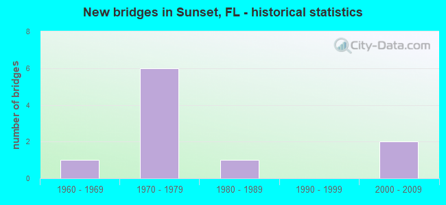
- New bridges - historical statistics
- 11960-1969
- 61970-1979
- 11980-1989
- 22000-2009


- Bridge Condition - Deck
- 42.9%Very good
- 57.1%Good

- Bridge Condition - Superstructure
- 28.6%Very good
- 71.4%Good

- Bridge Condition - Substructure
- 14.3%Very good
- 85.7%Good

- Bridge Condition - Channel
- 75.0%Good
- 25.0%Fair
Find on map >> Show street view
Structure Number: 870495, Location: 0.4 miles North of SR 94 (Lat: 25.692111, Lng: -80.347444), Route carried "on" structure: State highway 874, Year Built: 1975, Year Reconstructed: 2013, Status: Open, Structure Length: 4.11m (13.48ft), Average Daily Traffic: 62,750 (year 2020), Truck Traffic: 8%, Average Future Daily Traffic: 108,871 (year 2042), Design Load: HS 20, Features Intersected: SNAPPER CREEK CANAL C-2
Minimum Vertical Clearance: 30+ m (98+ ft), Kilometerpoint: 6.529, Lanes on structure: 6, Toll: On toll road, Owner: State Toll Authority, Approaching Roadway Width: 29.9m (98.1ft), Skew: 31 degrees, Material/Design: Prestressed concrete, Design/Construction: Stringer/Multi-beam, Number Of Spans In Main Unit: 3, Length of Maximum Span: 14.6m (47.9ft), Curb-To-Curb Width: 29.9m (98.1ft), Out-to-Out Width: 34.4m (112.9ft)
Condition: Deck: Very good, Superstructure: Very good, Substructure: Very good, Channel: Good, Operating Rating: 55.2 metric tons, Method Used To Determine Operating Rating: Load and Resistance Factor (LRFR), Inventory Rating: 42.5 metric tons, Method Used To Determine Inventory Rating: Load and Resistance Factor (LRFR), Structural Evaluation: Equal to present desirable criteria, Deck Geometry: Superior to present desirable criteria, Waterway Adequacy: Equal to present minimum criteria, Approach Roadway Alignment: Equal to present desirable criteria, Designated Inspection Frequency: Every 24 months, Underwater Inspection Frequency: Every 24 months, Inspection Date: August 2020, Underwater Inspection Date: August 2020, Deck Structure Type: Concrete Cast-file-Place, Wearing Surface/Protective System: Wearing Surface: Monolithic Concrete
Find on map >> Show street view
Structure Number: 870496, Location: 0.4 miles North of SR 94 (Lat: 25.692000, Lng: -80.347181), Route carried "on" structure: State highway 874, Year Built: 1975, Year Reconstructed: 2007, Status: Open, Structure Length: 4.11m (13.48ft), Average Daily Traffic: 62,750 (year 2020), Truck Traffic: 8%, Average Future Daily Traffic: 108,871 (year 2042), Design Load: HS 20, Features Intersected: SNAPPER CREEK CANAL C-2
Minimum Vertical Clearance: 30+ m (98+ ft), Kilometerpoint: 6.502, Lanes on structure: 5, Toll: On toll road, Owner: State Toll Authority, Approaching Roadway Width: 28.8m (94.5ft), Skew: 31 degrees, Material/Design: Prestressed concrete, Design/Construction: Stringer/Multi-beam, Number Of Spans In Main Unit: 3, Length of Maximum Span: 14.6m (47.9ft), Curb-To-Curb Width: 28.8m (94.5ft), Out-to-Out Width: 30.5m (100.1ft)
Condition: Deck: Very good, Superstructure: Very good, Substructure: Good, Channel: Fair, Operating Rating: 50.0 metric tons, Method Used To Determine Operating Rating: Load and Resistance Factor (LRFR), Inventory Rating: 38.2 metric tons, Method Used To Determine Inventory Rating: Load and Resistance Factor (LRFR), Structural Evaluation: Better than present minimum criteria, Deck Geometry: Superior to present desirable criteria, Waterway Adequacy: Equal to present desirable criteria, Approach Roadway Alignment: Equal to present desirable criteria, Designated Inspection Frequency: Every 24 months, Underwater Inspection Frequency: Every 24 months, Inspection Date: August 2020, Underwater Inspection Date: August 2020, Deck Structure Type: Concrete Cast-file-Place, Wearing Surface/Protective System: Wearing Surface: Monolithic Concrete
Find on map >> Show street view
Structure Number: 870522, Location: 1 mile North of SR 94 (Lat: 25.702111, Lng: -80.338292), Route carried "on" structure: State highway 874, Year Built: 1975, Year Reconstructed: 2013, Status: Open, Structure Length: 7.67m (25.16ft), Average Daily Traffic: 49,750 (year 2020), Truck Traffic: 7%, Average Future Daily Traffic: 86,316 (year 2042), Design Load: HL 93, Features Intersected: SW 72nd St (SUNSET DR)
Minimum Vertical Clearance: 30+ m (98+ ft), Kilometerpoint: 7.982, Lanes on structure: 3, Lanes under structure: 4, Toll: On toll road, Owner: State Toll Authority, Approaching Roadway Width: 19.2m (63.0ft), Skew: 4 degrees, Material/Design: Prestressed concrete, Design/Construction: Stringer/Multi-beam, Number Of Spans In Main Unit: 4, Length of Maximum Span: 22.2m (72.8ft), Curb-To-Curb Width: 17.2m (56.4ft), Out-to-Out Width: 18.0m (59.1ft)
Condition: Deck: Good, Superstructure: Good, Substructure: Good, Operating Rating: 38.2 metric tons, Method Used To Determine Operating Rating: Load and Resistance Factor (LRFR), Inventory Rating: 34.7 metric tons, Method Used To Determine Inventory Rating: Load and Resistance Factor (LRFR), Structural Evaluation: Better than present minimum criteria, Deck Geometry: Better than present minimum criteria, Underclear: Equal to present minimum criteria, Approach Roadway Alignment: Equal to present desirable criteria, Designated Inspection Frequency: Every 24 months, Inspection Date: January 2022, Deck Structure Type: Concrete Cast-file-Place
Find on map >> Show street view
Structure Number: 870523, Location: 1mile North of SR 94 (Lat: 25.702139, Lng: -80.337889), Route carried "on" structure: State highway 874, Year Built: 1975, Year Reconstructed: 2013, Status: Open, Structure Length: 7.67m (25.16ft), Average Daily Traffic: 49,750 (year 2020), Truck Traffic: 7%, Average Future Daily Traffic: 86,316 (year 2042), Design Load: HL 93, Features Intersected: SW 72nd St (SUNSET DR)
Minimum Vertical Clearance: 30+ m (98+ ft), Kilometerpoint: 8.010, Lanes on structure: 2, Lanes under structure: 4, Toll: On toll road, Owner: State Toll Authority, Approaching Roadway Width: 19.2m (63.0ft), Skew: 4 degrees, Material/Design: Prestressed concrete, Design/Construction: Stringer/Multi-beam, Number Of Spans In Main Unit: 4, Length of Maximum Span: 22.2m (72.8ft), Curb-To-Curb Width: 17.1m (56.1ft), Out-to-Out Width: 18.0m (59.1ft)
Condition: Deck: Very good, Superstructure: Good, Substructure: Good, Operating Rating: 38.2 metric tons, Method Used To Determine Operating Rating: Load and Resistance Factor (LRFR), Inventory Rating: 34.7 metric tons, Method Used To Determine Inventory Rating: Load and Resistance Factor (LRFR), Structural Evaluation: Better than present minimum criteria, Deck Geometry: Superior to present desirable criteria, Underclear: Equal to present minimum criteria, Approach Roadway Alignment: Equal to present desirable criteria, Designated Inspection Frequency: Every 24 months, Inspection Date: January 2022, Deck Structure Type: Concrete Cast-file-Place
Find on map >> Show street view
Structure Number: 870692, Location: 100 ft. N/O SW 72 ST (Lat: 25.701736, Lng: -80.366192), Route carried "on" structure: State highway 985, Year Built: 1985, Status: Open, Structure Length: 3.84m (12.60ft), Average Daily Traffic: 22,500 (year 2020), Truck Traffic: 9%, Average Future Daily Traffic: 39,038 (year 2042), Design Load: HL 93, Features Intersected: SNAPPER CREEK CANAL C-2
Minimum Vertical Clearance: 30+ m (98+ ft), Kilometerpoint: 3.315, Lanes on structure: 5, Owner: State Highway Agency, Approaching Roadway Width: 21.6m (70.9ft), Skew: 3 degrees, Material/Design: Prestressed concrete, Design/Construction: Slab, Number Of Spans In Main Unit: 3, Length of Maximum Span: 12.8m (42.0ft), Curb or Sidewalk Widths: Left: 1.9m (6.2ft), Right: 0.0m, Curb-To-Curb Width: 21.6m (70.9ft), Out-to-Out Width: 25.2m (82.7ft)
Condition: Deck: Good, Superstructure: Good, Substructure: Good, Channel: Good, Operating Rating: 55.5 metric tons, Method Used To Determine Operating Rating: Load and Resistance Factor (LRFR), Inventory Rating: 37.2 metric tons, Method Used To Determine Inventory Rating: Load and Resistance Factor (LRFR), Structural Evaluation: Better than present minimum criteria, Deck Geometry: Somewhat better than minimum adequacy, Waterway Adequacy: Better than present minimum criteria, Approach Roadway Alignment: Equal to present desirable criteria, Designated Inspection Frequency: Every 24 months, Underwater Inspection Frequency: Every 24 months, Inspection Date: July 2021, Underwater Inspection Date: July 2021, Deck Structure Type: Concrete Cast-file-Place, Wearing Surface/Protective System: Wearing Surface: Monolithic Concrete
Find on map >> Show street view
Structure Number: 871024, Location: SR 94 to SR 874 (Lat: 25.693278, Lng: -80.345611), Route carried "on" structure: Ramp State highway 874, Year Built: 2008, Status: Open, Structure Length: 66.07m (216.77ft), Average Daily Traffic: 6,100 (year 2020), Truck Traffic: 3%, Average Future Daily Traffic: 10,584 (year 2042), Design Load: HL 93, Features Intersected: EB SR878 On ramp & Canal
Minimum Vertical Clearance: 30.18m (99.02ft), Kilometerpoint: 0.156, Lanes on structure: 1, Lanes under structure: 3, Toll: On toll road, Owner: State Toll Authority, Approaching Roadway Width: 8.2m (26.9ft), Material/Design: Steel, Design/Construction: Box Beam or Girders - Single/Spread, Number Of Spans In Main Unit: 11, Length of Maximum Span: 80.9m (265.4ft), Curb-To-Curb Width: 8.2m (26.9ft), Out-to-Out Width: 9.2m (30.2ft)
Condition: Deck: Good, Superstructure: Good, Substructure: Good, Operating Rating: 47.1 metric tons, Method Used To Determine Operating Rating: Load and Resistance Factor (LRFR), Inventory Rating: 36.3 metric tons, Method Used To Determine Inventory Rating: Load and Resistance Factor (LRFR), Structural Evaluation: Better than present minimum criteria, Deck Geometry: Superior to present desirable criteria, Underclear: Meets minimum limits, Approach Roadway Alignment: Equal to present desirable criteria, Designated Inspection Frequency: Every 24 months, Critical Feature Inspection Frequency: Every 24 months, Inspection Date: November 2020, Critical Feature Inspection Date: November 2020, Deck Structure Type: Concrete Cast-file-Place, Wearing Surface/Protective System: Wearing Surface: Monolithic Concrete
Find on map >> Show street view
Structure Number: 874254, Location: 200Ft. E of SW 99th Ave. (Lat: 25.695833, Lng: -80.354000), Route carried "on" structure: County highway , Year Built: 1960, Status: Open, Structure Length: 0.64m (2.10ft), Average Daily Traffic: 5,314 (year 2020), Truck Traffic: 5%, Average Future Daily Traffic: 9,245 (year 2042), Design Load: HS 20, Features Intersected: Sunset Park Canal, Facility Carried by Structure: Snapper Creek Dr.
Minimum Vertical Clearance: 30.18m (99.02ft), Kilometerpoint: 0.058, Lanes on structure: 2, Owner: County Highway Agency, Approaching Roadway Width: 6.1m (20.0ft), Material/Design: Prestressed concrete, Design/Construction: Slab, Number Of Spans In Main Unit: 1, Length of Maximum Span: 6.4m (21.0ft), Curb or Sidewalk Widths: Left: 1.5m (4.9ft), Right: 1.5m (4.9ft), Curb-To-Curb Width: 8.9m (29.2ft), Out-to-Out Width: 12.0m (39.4ft)
Condition: Deck: Good, Superstructure: Good, Substructure: Good, Channel: Good, Operating Rating: 46.7 metric tons, Method Used To Determine Operating Rating: Load Factor (LF), Inventory Rating: 27.9 metric tons, Method Used To Determine Inventory Rating: Load Factor (LF), Structural Evaluation: Better than present minimum criteria, Deck Geometry: High priority of replacement, Waterway Adequacy: Better than present minimum criteria, Approach Roadway Alignment: Equal to present desirable criteria, Designated Inspection Frequency: Every 24 months, Underwater Inspection Frequency: Every 24 months, Inspection Date: August 2021, Underwater Inspection Date: August 2021, Deck Structure Type: Concrete Precast Panels, Wearing Surface/Protective System: Wearing Surface: Monolithic Concrete
Find on map >> Show street view
Structure Number: 870522, Location: 1 mile North of SR 94 (Lat: 25.702111, Lng: -80.338292), Route carried "under" structure: State highway 986, Year Built: 1975, Structure Length: 0. m, Average Daily Traffic: 41,500 (year 2020), Truck Traffic: 5%, Features Intersected: SW 72nd St (SUNSET DR), Facility Carried by Structure: SR 874 SB
Minimum Vertical Clearance: 4.97m (16.31ft), Kilometerpoint: 7.982, Lanes on structure: 3, Lanes under structure: 4, Material/Design: Prestressed concrete, Design/Construction: Stringer/Multi-beam, Length of Maximum Span: 22.2m (72.8ft)
Find on map >> Show street view
Structure Number: 870523, Location: 1mile North of SR 94 (Lat: 25.702139, Lng: -80.337889), Route carried "under" structure: State highway 986, Year Built: 1975, Structure Length: 0. m, Average Daily Traffic: 41,500 (year 2018), Truck Traffic: 5%, Features Intersected: SW 72nd St (SUNSET DR), Facility Carried by Structure: SR 874 NB
Minimum Vertical Clearance: 4.97m (16.31ft), Kilometerpoint: 8.137, Lanes on structure: 2, Lanes under structure: 4, Material/Design: Prestressed concrete, Design/Construction: Stringer/Multi-beam, Length of Maximum Span: 22.2m (72.8ft)
Find on map >> Show street view
Structure Number: 871024, Location: SR 94 to SR 874 (Lat: 25.693278, Lng: -80.345611), Route carried "under" structure: Ramp State highway 878, Year Built: 2008, Structure Length: 0. m, Average Daily Traffic: 20,500 (year 2020), Truck Traffic: 3%, Features Intersected: EB SR878 On ramp & Canal, Facility Carried by Structure: SR 874 NB On Ramp
Minimum Vertical Clearance: 5.49m (18.01ft), Kilometerpoint: 0.000, Lanes on structure: 1, Lanes under structure: 3, Toll: On toll road, Material/Design: Steel, Design/Construction: Box Beam or Girders - Single/Spread, Length of Maximum Span: 80.9m (265.4ft)