Bridge Statistics for Stone Ridge, Virginia (VA)
Condition, Traffic, Stress, Structural Evaluation, Project Costs
- National Bridge Inventory (NBI) Statistics
- 14Number of bridges
- 72ft / 21.6mTotal length
- $530,000Total costs
- 18,417Total average daily traffic
- 51Total average daily truck traffic
- 28,278Total future (year 2031) average daily traffic
- National Bridge Inventory (NBI) Registered Bridges for Stone Ridge
- No street view available for this location
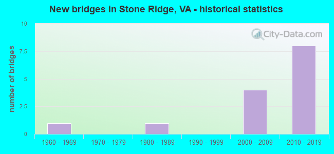
- New bridges - historical statistics
- 11960-1969
- 11980-1989
- 42000-2009
- 82010-2019


- Bridge Condition - Deck
- 33.3%Very good
- 33.3%Good
- 33.3%Fair

- Bridge Condition - Superstructure
- 25.0%Very good
- 50.0%Good
- 25.0%Fair

- Bridge Condition - Substructure
- 25.0%Very good
- 50.0%Good
- 25.0%Fair

- Bridge Condition - Channel
- 21.4%Very good
- 35.7%Good
- 28.6%Satisfactory
- 14.3%Fair

- Bridge Condition - Culverts
- 30.0%Very good
- 50.0%Good
- 10.0%Satisfactory
- 10.0%Fair
Find on map >> Show street view
Structure Number: 11298, Location: 02.60FR620/01.00TO2018 (Lat: 38.889544, Lng: -77.570306), Route carried "on" structure: County highway 705, Year Built: 1966, Status: Open, Structure Length: 2.62m (8.60ft), Average Daily Traffic: 731 (year 2014), Average Future Daily Traffic: 961 (year 2035), Design Load: HS 20, Features Intersected: BULL RUN, Facility Carried by Structure: AUBURN FARM RD
Minimum Vertical Clearance: 30+ m (98+ ft), Kilometerpoint: 9.654, Lanes on structure: 1, Owner: State Highway Agency, Approaching Roadway Width: 6.7m (22.0ft), Material/Design: Steel, Design/Construction: Stringer/Multi-beam, Number Of Spans In Main Unit: 1, Length of Maximum Span: 26.2m (86.0ft), Curb or Sidewalk Widths: Left: 0.2m (0.7ft), Right: 0.2m (0.7ft), Curb-To-Curb Width: 4.3m (14.1ft), Out-to-Out Width: 4.7m (15.4ft)
Condition: Deck: Fair, Superstructure: Fair, Substructure: Fair, Channel: Satisfactory, Operating Rating: 77.1 metric tons, Method Used To Determine Operating Rating: Load and Resistance Factor (LRFR), Inventory Rating: 59.4 metric tons, Method Used To Determine Inventory Rating: Load and Resistance Factor (LRFR), Structural Evaluation: Somewhat better than minimum adequacy, Deck Geometry: High priority of replacement, Waterway Adequacy: Equal to present desirable criteria, Approach Roadway Alignment: Equal to present minimum criteria, Length Of Structure Improvement: 2.62m (8.60ft), Designated Inspection Frequency: Every 24 months, Inspection Date: July 2021, Bridge Improvement Cost: $100,000, Roadway Improvement Cost: $20,000, Total Project Cost: $130,000 ( Estimate for 2015), Deck Structure Type: Concrete Cast-file-Place
Find on map >> Show street view
Structure Number: 14374, Location: 01.60 624 / 00.70 601 (Lat: 38.888222, Lng: -77.594000), Route carried "on" structure: County highway 701, Year Built: 1984, Status: Posted for load, Structure Length: 1.92m (6.30ft), Average Daily Traffic: 122 (year 2013), Average Future Daily Traffic: 188 (year 2040), Design Load: HS 20, Features Intersected: CHESTNUT LICK RUN, Facility Carried by Structure: LOGMILL ROAD
Minimum Vertical Clearance: 30+ m (98+ ft), Kilometerpoint: 7.014, Lanes on structure: 2, Owner: State Highway Agency, Approaching Roadway Width: 5.5m (18.0ft), Skew: 1 degrees, Material/Design: Steel, Design/Construction: Culvert, Number Of Spans In Main Unit: 3, Length of Maximum Span: 5.2m (17.1ft)
Condition: Channel: Fair, Culverts: Fair, Operating Rating: 36.3 metric tons, Method Used To Determine Operating Rating: Load Factor (LF), Inventory Rating: 32.7 metric tons, Method Used To Determine Inventory Rating: Load Factor (LF), Structural Evaluation: Somewhat better than minimum adequacy, Waterway Adequacy: Equal to present minimum criteria, Approach Roadway Alignment: Somewhat better than minimum adequacy, Length Of Structure Improvement: 1.92m (6.30ft), Designated Inspection Frequency: Every 24 months, Other Special Inspection Frequency: Every 12 months, Inspection Date: Febuary 2021, Other Special Inspection Date: Febuary 2022, Bridge Improvement Cost: $125,000, Roadway Improvement Cost: $13,000, Total Project Cost: $200,000 ( Estimate for 2015)
Find on map >> Show street view
Structure Number: 28425, Location: 00.40FR659/01.08TO616 (Lat: 38.913006, Lng: -77.551578), Route carried "on" structure: County highway 620, Year Built: 2006, Status: Open, Structure Length: 1.34m (4.40ft), Average Daily Traffic: 5,432 (year 2020), Average Future Daily Traffic: 6,902 (year 2040), Design Load: HS 20, Features Intersected: FOLEY BRANCH
Minimum Vertical Clearance: 30+ m (98+ ft), Kilometerpoint: 0.000, Lanes on structure: 2, Owner: State Highway Agency, Approaching Roadway Width: 7.9m (25.9ft), Material/Design: Concrete, Design/Construction: Culvert, Number Of Spans In Main Unit: 4, Length of Maximum Span: 3.0m (9.8ft), Curb or Sidewalk Widths: Left: 0.0m, Right: 2.4m (7.9ft)
Condition: Channel: Satisfactory, Culverts: Satisfactory, Operating Rating: 63.5 metric tons, Method Used To Determine Operating Rating: Load Factor (LF), Inventory Rating: 38.1 metric tons, Method Used To Determine Inventory Rating: Load Factor (LF), Structural Evaluation: Equal to present minimum criteria, Waterway Adequacy: Equal to present desirable criteria, Approach Roadway Alignment: Equal to present desirable criteria, Length Of Structure Improvement: 14.02m (46.00ft), Designated Inspection Frequency: Every 24 months, Inspection Date: January 2021, Bridge Improvement Cost: $25,000, Roadway Improvement Cost: $55,000, Total Project Cost: $100,000 ( Estimate for 2015)
Find on map >> Show street view
Structure Number: 28627, Location: 00.20FR620/00.10TO EXPER (Lat: 38.912975, Lng: -77.558378), Route carried "on" structure: County highway 1258, Year Built: 2007, Status: Open, Structure Length: 1.17m (3.84ft), Average Daily Traffic: 2,122 (year 2010), Truck Traffic: 1%, Average Future Daily Traffic: 2,440 (year 2040), Design Load: HS 20+Mod, Features Intersected: TRIB. OF ELKLICK RUN, Facility Carried by Structure: SUMMERALL DR.
Minimum Vertical Clearance: 30.45m (99.90ft), Kilometerpoint: 0.000, Lanes on structure: 2, Owner: State Highway Agency, Approaching Roadway Width: 8.5m (27.9ft), Material/Design: Concrete, Design/Construction: Culvert, Number Of Spans In Main Unit: 3, Length of Maximum Span: 3.7m (12.1ft), Curb or Sidewalk Widths: Left: 1.2m (3.9ft), Right: 0.0m
Condition: Channel: Very good, Culverts: Very good, Operating Rating: 68.9 metric tons, Method Used To Determine Operating Rating: Load Factor (LF), Inventory Rating: 40.8 metric tons, Method Used To Determine Inventory Rating: Load Factor (LF), Structural Evaluation: Equal to present desirable criteria, Waterway Adequacy: Equal to present desirable criteria, Approach Roadway Alignment: Equal to present desirable criteria, Designated Inspection Frequency: Every 24 months, Inspection Date: June 2020
Find on map >> Show street view
Structure Number: 28629, Location: 00.30FR0659/00.20TO0000 (Lat: 38.915697, Lng: -77.551233), Route carried "on" structure: County highway 1252, Year Built: 2005, Status: Open, Structure Length: 0.70m (2.30ft), Average Daily Traffic: 1,378 (year 2010), Average Future Daily Traffic: 1,585 (year 2040), Design Load: HS 20+Mod, Features Intersected: TRIB ELKLICK RUN, Facility Carried by Structure: DESTINY DR.
Minimum Vertical Clearance: 30.45m (99.90ft), Kilometerpoint: 0.000, Lanes on structure: 2, Owner: State Highway Agency, Approaching Roadway Width: 7.3m (24.0ft), Material/Design: Concrete, Design/Construction: Culvert, Number Of Spans In Main Unit: 2, Length of Maximum Span: 3.0m (9.8ft)
Condition: Channel: Good, Culverts: Good, Operating Rating: 84.4 metric tons, Method Used To Determine Operating Rating: Load Factor (LF), Inventory Rating: 49.9 metric tons, Method Used To Determine Inventory Rating: Load Factor (LF), Structural Evaluation: Better than present minimum criteria, Waterway Adequacy: Equal to present desirable criteria, Approach Roadway Alignment: Equal to present desirable criteria, Designated Inspection Frequency: Every 24 months, Inspection Date: May 2020
Find on map >> Show street view
Structure Number: 2902, Location: 01.00FR659/00.75TO616 (Lat: 38.917917, Lng: -77.561342), Route carried "on" structure: Alternate County highway 620, Year Built: 2008, Status: Open, Structure Length: 0.67m (2.20ft), Average Daily Traffic: 5,432 (year 2020), Average Future Daily Traffic: 6,902 (year 2040), Design Load: HS 20, Features Intersected: TRIB OF BULL RUN, Facility Carried by Structure: BRADDOCK RD.
Minimum Vertical Clearance: 30+ m (98+ ft), Kilometerpoint: 0.000, Lanes on structure: 2, Owner: State Highway Agency, Approaching Roadway Width: 7.3m (24.0ft), Material/Design: Concrete, Design/Construction: Arch - Deck, Number Of Spans In Main Unit: 1, Length of Maximum Span: 6.1m (20.0ft), Curb-To-Curb Width: 7.3m (24.0ft), Out-to-Out Width: 36.6m (120.1ft)
Condition: Superstructure: Good, Substructure: Good, Channel: Satisfactory, Operating Rating: 59.6 metric tons, Method Used To Determine Operating Rating: Load and Resistance Factor (LRFR), Inventory Rating: 46.0 metric tons, Method Used To Determine Inventory Rating: Load and Resistance Factor (LRFR), Structural Evaluation: Better than present minimum criteria, Deck Geometry: High priority of replacement, Waterway Adequacy: Equal to present desirable criteria, Approach Roadway Alignment: Equal to present desirable criteria, Length Of Structure Improvement: 3.90m (12.80ft), Designated Inspection Frequency: Every 24 months, Inspection Date: March 2021, Bridge Improvement Cost: $29,000, Roadway Improvement Cost: $55,000, Total Project Cost: $100,000, Deck Structure Type: Other
Find on map >> Show street view
Structure Number: 30212, Location: 0.40fr 659 0.10toSuccess (Lat: 38.906556, Lng: -77.553833), Route carried "on" structure: Alternate City street , Year Built: 2013, Status: Open, Structure Length: 1.28m (4.20ft), Average Daily Traffic: 200 (year 2013), Truck Traffic: 1%, Average Future Daily Traffic: 800 (year 2035), Design Load: HS 20+Mod, Features Intersected: Trib of Foley Branch, Facility Carried by Structure: LENNOX HALE DRIVE
Minimum Vertical Clearance: 30.18m (99.02ft), Kilometerpoint: 0.000, Lanes on structure: 2, Owner: State Highway Agency, Approaching Roadway Width: 8.2m (26.9ft), Material/Design: Concrete, Design/Construction: Culvert, Number Of Spans In Main Unit: 4, Length of Maximum Span: 3.0m (9.8ft), Curb-To-Curb Width: 8.2m (26.9ft), Out-to-Out Width: 22.3m (73.2ft)
Condition: Channel: Good, Culverts: Good, Operating Rating: 89.8 metric tons, Method Used To Determine Operating Rating: Load Factor (LF), Inventory Rating: 59.0 metric tons, Method Used To Determine Inventory Rating: Load Factor (LF), Structural Evaluation: Better than present minimum criteria, Deck Geometry: Somewhat better than minimum adequacy, Waterway Adequacy: Better than present minimum criteria, Approach Roadway Alignment: Better than present minimum criteria, Designated Inspection Frequency: Every 24 months, Inspection Date: June 2021
Find on map >> Show street view
Structure Number: 30213, Location: 0.1fr Lenno 0.1to Suff (Lat: 38.906578, Lng: -77.558703), Route carried "on" structure: County highway 1297, Year Built: 2013, Status: Open, Structure Length: 2.34m (7.68ft), Average Daily Traffic: 100 (year 2013), Truck Traffic: 1%, Average Future Daily Traffic: 1,000 (year 2033), Design Load: HS 20, Features Intersected: FOLEY BRANCH, Facility Carried by Structure: SUCCESS DRIVE
Minimum Vertical Clearance: 30.18m (99.02ft), Kilometerpoint: 0.000, Lanes on structure: 2, Owner: State Highway Agency, Approaching Roadway Width: 7.9m (25.9ft), Material/Design: Concrete, Design/Construction: Culvert, Number Of Spans In Main Unit: 6, Length of Maximum Span: 3.7m (12.1ft)
Condition: Channel: Satisfactory, Culverts: Good, Operating Rating: 75.3 metric tons, Method Used To Determine Operating Rating: Field evaluation and documented engineering judgment, Inventory Rating: 44.5 metric tons, Method Used To Determine Inventory Rating: Field evaluation and documented engineering judgment, Structural Evaluation: Better than present minimum criteria, Waterway Adequacy: Equal to present desirable criteria, Approach Roadway Alignment: Better than present minimum criteria, Designated Inspection Frequency: Every 24 months, Inspection Date: October 2021
Find on map >> Show street view
Structure Number: 303, Location: 00.40 fr 620 (Lat: 38.932944, Lng: -77.582650), Route carried "on" structure: County highway 3395, Year Built: 2013, Status: Open, Structure Length: 1.65m (5.41ft), Average Daily Traffic: 500 (year 2013), Truck Traffic: 1%, Average Future Daily Traffic: 1,500 (year 2031), Design Load: HS 20, Features Intersected: S.Fork Broad Run, Facility Carried by Structure: TRAILHEAD DRIVE
Minimum Vertical Clearance: 30.18m (99.02ft), Kilometerpoint: 0.000, Lanes on structure: 2, Owner: State Highway Agency, Approaching Roadway Width: 13.7m (44.9ft), Material/Design: Concrete, Design/Construction: Culvert, Number Of Spans In Main Unit: 5, Length of Maximum Span: 3.0m (9.8ft), Curb-To-Curb Width: 9.1m (29.9ft), Out-to-Out Width: 15.2m (49.9ft)
Condition: Channel: Very good, Culverts: Good, Operating Rating: 89.8 metric tons, Method Used To Determine Operating Rating: Load Factor (LF), Inventory Rating: 59.0 metric tons, Method Used To Determine Inventory Rating: Load Factor (LF), Structural Evaluation: Better than present minimum criteria, Deck Geometry: Equal to present minimum criteria, Waterway Adequacy: Somewhat better than minimum adequacy, Approach Roadway Alignment: Better than present minimum criteria, Designated Inspection Frequency: Every 24 months, Inspection Date: January 2022
Find on map >> Show street view
Structure Number: 30301, Location: 0.30fr620 0.01to Darkm (Lat: 38.931700, Lng: -77.582450), Route carried "on" structure: County highway 3395, Year Built: 2013, Status: Open, Structure Length: 1.00m (3.28ft), Average Daily Traffic: 500 (year 2013), Truck Traffic: 1%, Average Future Daily Traffic: 1,500 (year 2031), Design Load: HS 20, Features Intersected: S.Fork Broad Run, Facility Carried by Structure: TRAILHEAD DRIVE
Minimum Vertical Clearance: 30.18m (99.02ft), Kilometerpoint: 0.000, Lanes on structure: 2, Owner: State Highway Agency, Approaching Roadway Width: 13.7m (44.9ft), Material/Design: Concrete, Design/Construction: Culvert, Number Of Spans In Main Unit: 3, Length of Maximum Span: 3.0m (9.8ft)
Condition: Channel: Fair, Culverts: Very good, Operating Rating: 89.8 metric tons, Method Used To Determine Operating Rating: Load Factor (LF), Inventory Rating: 64.4 metric tons, Method Used To Determine Inventory Rating: Load Factor (LF), Structural Evaluation: Equal to present desirable criteria, Waterway Adequacy: Somewhat better than minimum adequacy, Approach Roadway Alignment: Better than present minimum criteria, Designated Inspection Frequency: Every 24 months, Inspection Date: January 2022
Find on map >> Show street view
Structure Number: 30364, Location: 0.12fr705 0.18to Circle (Lat: 38.908925, Lng: -77.573944), Route carried "on" structure: Alternate County highway 3394, Year Built: 2015, Status: Open, Structure Length: 3.41m (11.19ft), Average Daily Traffic: 500 (year 2015), Truck Traffic: 1%, Average Future Daily Traffic: 1,200 (year 2035), Design Load: HL 93, Features Intersected: LENAH RUN, Facility Carried by Structure: GRASSLAND GROVE
Minimum Vertical Clearance: 30.18m (99.02ft), Kilometerpoint: 0.000, Lanes on structure: 2, Owner: State Highway Agency, Approaching Roadway Width: 11.6m (38.1ft), Material/Design: Steel, Design/Construction: Truss - Thru, Number Of Spans In Main Unit: 1, Length of Maximum Span: 33.5m (109.9ft), Curb-To-Curb Width: 7.3m (24.0ft), Out-to-Out Width: 9.4m (30.8ft)
Condition: Deck: Good, Superstructure: Good, Substructure: Good, Channel: Good, Operating Rating: 57.0 metric tons, Method Used To Determine Operating Rating: Load and Resistance Factor (LRFR), Inventory Rating: 43.8 metric tons, Method Used To Determine Inventory Rating: Load and Resistance Factor (LRFR), Structural Evaluation: Better than present minimum criteria, Deck Geometry: Meets minimum limits, Waterway Adequacy: Equal to present minimum criteria, Approach Roadway Alignment: Better than present minimum criteria, Designated Inspection Frequency: Every 24 months, Critical Feature Inspection Frequency: Every 24 months, Inspection Date: January 2022, Critical Feature Inspection Date: January 2022, Deck Structure Type: Concrete Cast-file-Place, Wearing Surface/Protective System: Wearing Surface: Monolithic Concrete, Deck Protection: Epoxy Coated Reinforcing
Find on map >> Show street view
Structure Number: 30699, Location: 0.13fr LRP 0.30to End (Lat: 38.952778, Lng: -77.575483), Route carried "on" structure: County highway 3701, Year Built: 2015, Status: Open, Structure Length: 1.04m (3.41ft), Average Daily Traffic: 200 (year 2015), Truck Traffic: 1%, Average Future Daily Traffic: 800 (year 2035), Design Load: HS 20, Features Intersected: LENAH RUN, Facility Carried by Structure: MILL WHEEL PLACE
Minimum Vertical Clearance: 30.18m (99.02ft), Kilometerpoint: 0.000, Lanes on structure: 2, Owner: State Highway Agency, Approaching Roadway Width: 7.6m (24.9ft), Material/Design: Concrete, Design/Construction: Arch - Deck, Number Of Spans In Main Unit: 1, Length of Maximum Span: 9.8m (32.2ft), Curb-To-Curb Width: 7.3m (24.0ft), Out-to-Out Width: 19.8m (65.0ft)
Condition: Deck: Very good, Superstructure: Very good, Substructure: Very good, Channel: Good, Operating Rating: 61.5 metric tons, Method Used To Determine Operating Rating: Load and Resistance Factor (LRFR), Inventory Rating: 51.9 metric tons, Method Used To Determine Inventory Rating: Load and Resistance Factor (LRFR), Structural Evaluation: Equal to present desirable criteria, Deck Geometry: Somewhat better than minimum adequacy, Waterway Adequacy: Equal to present minimum criteria, Approach Roadway Alignment: Equal to present minimum criteria, Designated Inspection Frequency: Every 24 months, Inspection Date: March 2021, Deck Structure Type: Other, Wearing Surface/Protective System: Membrane: Preformed Fabric, Deck Protection: Galvanized Reinforcing
Find on map >> Show street view
Structure Number: 30712, Location: 0.40fr Sev 0.10to Lennox (Lat: 38.899825, Lng: -77.552431), Route carried "on" structure: County highway 3315, Year Built: 2016, Status: Open, Structure Length: 1.32m (4.33ft), Average Daily Traffic: 1,000 (year 2015), Truck Traffic: 1%, Average Future Daily Traffic: 2,200 (year 2035), Design Load: HS 20, Features Intersected: Foley Branch, Facility Carried by Structure: WINNING GLORY DR.
Minimum Vertical Clearance: 30.18m (99.02ft), Kilometerpoint: 0.000, Lanes on structure: 2, Owner: State Highway Agency, Approaching Roadway Width: 9.1m (29.9ft), Skew: 1 degrees, Material/Design: Concrete, Design/Construction: Culvert, Number Of Spans In Main Unit: 4, Length of Maximum Span: 3.0m (9.8ft), Curb or Sidewalk Widths: Left: 1.2m (3.9ft), Right: 1.2m (3.9ft)
Condition: Channel: Good, Culverts: Good, Operating Rating: 89.8 metric tons, Method Used To Determine Operating Rating: Load Factor (LF), Inventory Rating: 61.7 metric tons, Method Used To Determine Inventory Rating: Load Factor (LF), Structural Evaluation: Better than present minimum criteria, Waterway Adequacy: Better than present minimum criteria, Approach Roadway Alignment: Equal to present minimum criteria, Designated Inspection Frequency: Every 24 months, Inspection Date: January 2022
Find on map >> Show street view
Structure Number: 30981, Location: 00.20fr50 00.20to0000 (Lat: 38.958269, Lng: -77.585250), Route carried "on" structure: County highway 3691, Year Built: 2017, Status: Open, Structure Length: 1.16m (3.81ft), Average Daily Traffic: 200 (year 2021), Average Future Daily Traffic: 300 (year 2035), Design Load: HS 20, Features Intersected: TRIB OF LENAH RUN, Facility Carried by Structure: MAPLEHURST DRIVE
Minimum Vertical Clearance: 30.18m (99.02ft), Kilometerpoint: 0.000, Lanes on structure: 2, Owner: State Highway Agency, Approaching Roadway Width: 8.2m (26.9ft), Material/Design: Concrete, Design/Construction: Culvert, Number Of Spans In Main Unit: 3, Length of Maximum Span: 3.7m (12.1ft), Curb or Sidewalk Widths: Left: 1.5m (4.9ft), Right: 1.5m (4.9ft)
Condition: Channel: Very good, Culverts: Very good, Operating Rating: 62.6 metric tons, Method Used To Determine Operating Rating: Load and Resistance Factor (LRFR), Inventory Rating: 47.2 metric tons, Method Used To Determine Inventory Rating: Load and Resistance Factor (LRFR), Structural Evaluation: Equal to present desirable criteria, Waterway Adequacy: Better than present minimum criteria, Approach Roadway Alignment: Better than present minimum criteria, Designated Inspection Frequency: Every 24 months, Inspection Date: March 2021