Bridge Statistics for Steubenville, Ohio (OH)
Condition, Traffic, Stress, Structural Evaluation, Project Costs
- National Bridge Inventory (NBI) Statistics
- 42Number of bridges
- 751ft / 229mTotal length
- $448,143,000Total costs
- 442,573Total average daily traffic
- 40,570Total average daily truck traffic
- National Bridge Inventory (NBI) Registered Bridges for Steubenville
- No street view available for this location
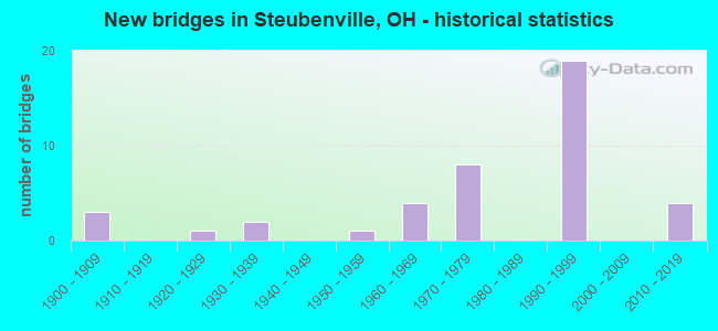
- New bridges - historical statistics
- 31900-1909
- 11920-1929
- 21930-1939
- 11950-1959
- 41960-1969
- 81970-1979
- 191990-1999
- 42010-2019

- Reconstructed bridges - Historical Statistics
- 11980-1989
- 41990-1999


- Bridge Condition - Deck
- 13.0%Excellent
- 8.7%Very good
- 34.8%Good
- 21.7%Satisfactory
- 17.4%Fair
- 4.3%Poor

- Bridge Condition - Superstructure
- 8.7%Excellent
- 17.4%Very good
- 39.1%Good
- 17.4%Satisfactory
- 8.7%Fair
- 4.3%Poor
- 4.3%Serious

- Bridge Condition - Substructure
- 8.7%Excellent
- 30.4%Very good
- 21.7%Good
- 26.1%Satisfactory
- 8.7%Fair
- 4.3%Serious

- Bridge Condition - Channel
- 30.8%Excellent
- 46.2%Good
- 23.1%Satisfactory

- Bridge Condition - Culverts
- 33.3%Excellent
- 33.3%Good
- 33.3%Satisfactory
Find on map >> Show street view
Structure Number: 4100905, Location: .68 M S OF MARKET ST (Lat: 40.351239, Lng: -80.619239), Route carried "on" structure: Ramp State highway 7, Year Built: 1962, Status: Open, Structure Length: 3.87m (12.70ft), Average Daily Traffic: 2,170 (year 2021), Truck Traffic: 2%, Average Future Daily Traffic: 10,464 (year 2041), Design Load: H 20, Features Intersected: SR 7 SB
Minimum Vertical Clearance: 30+ m (98+ ft), Kilometerpoint: 25.331, Lanes on structure: 2, Lanes under structure: 2, Owner: State Highway Agency, Approaching Roadway Width: 10.7m (35.1ft), Skew: 2 degrees, Material/Design: Concrete continuous, Design/Construction: Slab, Number Of Spans In Main Unit: 3, Length of Maximum Span: 13.4m (44.0ft), Curb or Sidewalk Widths: Left: 0.3m (1.0ft), Right: 0.3m (1.0ft), Curb-To-Curb Width: 8.7m (28.5ft), Out-to-Out Width: 10.2m (33.5ft)
Condition: Deck: Poor, Superstructure: Poor, Substructure: Satisfactory, Operating Rating: 38.9 metric tons, Method Used To Determine Operating Rating: Load Factor (LF) rating reported by rating factor (RF) method using MS18 loading, Inventory Rating: 22.7 metric tons, Method Used To Determine Inventory Rating: Load Factor (LF) rating reported by rating factor (RF) method using MS18 loading, Structural Evaluation: Meets minimum limits, Deck Geometry: Meets minimum limits, Underclear: High priority of corrective action, Approach Roadway Alignment: Somewhat better than minimum adequacy, Designated Inspection Frequency: Every 12 months, Inspection Date: October 2021, Deck Structure Type: Concrete Cast-file-Place, Wearing Surface/Protective System: Wearing Surface: Integral Concrete
Find on map >> Show street view
Structure Number: 4100964, Location: .7 MI N OF CONRAIL RR (Lat: 40.359211, Lng: -80.612489), Route carried "on" structure: City street WV2SP, Year Built: 1905, Status: Posted for load, Structure Length: 54.69m (179.43ft), Average Daily Traffic: 6,845 (year 2018), Truck Traffic: 3%, Average Future Daily Traffic: 9,501 (year 2038), Design Load: H 10, Features Intersected: SR-7, RR & OHIO RIVER, Facility Carried by Structure: MARKET ST-WVA2SPUR
Minimum Vertical Clearance: 4.12m (13.52ft), Kilometerpoint: 0.843, Lanes on structure: 2, Lanes under structure: 4, Base Highway Network: Yes, Owner: State Highway Agency, Approaching Roadway Width: 10.4m (34.1ft), Navigation Control: Yes ( Vertical Clearance: 22.6m (74.1ft), Horizontal Clearance: 20.7m (67.9ft)), Material/Design: Steel, Design/Construction: Suspension, Number Of Spans In Main Unit: 1, Number Of Approach Spans: 8, Length of Maximum Span: 213.4m (700.1ft), Curb or Sidewalk Widths: Left: 0.0m, Right: 1.8m (5.9ft), Curb-To-Curb Width: 6.3m (20.7ft), Out-to-Out Width: 6.5m (21.3ft)
Condition: Deck: Good, Superstructure: Serious, Substructure: Serious, Channel: Good, Operating Rating: 3.2 metric tons, Method Used To Determine Operating Rating: Load Factor (LF) rating reported by rating factor (RF) method using MS18 loading, Structural Evaluation: High priority of corrective action, Deck Geometry: High priority of replacement, Underclear: High priority of corrective action, Waterway Adequacy: Equal to present desirable criteria, Approach Roadway Alignment: Somewhat better than minimum adequacy, Bridge Posting: Required (Relationship of Operating Rating to Maximum Legal Load: > 39.9% below), Designated Inspection Frequency: Every 24 months, Critical Feature Inspection Frequency: Every 12 months, Underwater Inspection Frequency: Every 60 months, Other Special Inspection Frequency: Every 12 months, Inspection Date: June 2020, Critical Feature Inspection Date: June 2021, Underwater Inspection Date: August 2020, Other Special Inspection Date: June 2021, Deck Structure Type: Open Grating
Find on map >> Show street view
Structure Number: 4101014, Location: 1.17 MI SOUTH OF SR 213 (Lat: 40.377939, Lng: -80.615831), Route carried "on" structure: State highway 7, Year Built: 1993, Status: Open, Structure Length: 3.66m (12.01ft), Average Daily Traffic: 19,919 (year 2015), Truck Traffic: 14%, Average Future Daily Traffic: 27,648 (year 2035), Design Load: HS 20, Features Intersected: OVER WB. LANES U.S.22
Minimum Vertical Clearance: 30+ m (98+ ft), Kilometerpoint: 28.783, Lanes on structure: 3, Lanes under structure: 2, Base Highway Network: Yes, Owner: State Highway Agency, Approaching Roadway Width: 14.6m (47.9ft), Skew: 6 degrees, Material/Design: Steel, Design/Construction: Stringer/Multi-beam, Number Of Spans In Main Unit: 1, Length of Maximum Span: 32.9m (107.9ft), Curb-To-Curb Width: 24.7m (81.0ft), Out-to-Out Width: 25.5m (83.7ft)
Condition: Deck: Very good, Superstructure: Very good, Substructure: Very good, Operating Rating: 42.1 metric tons, Method Used To Determine Operating Rating: Load Factor (LF) rating reported by rating factor (RF) method using MS18 loading, Inventory Rating: 32.4 metric tons, Method Used To Determine Inventory Rating: Load Factor (LF) rating reported by rating factor (RF) method using MS18 loading, Structural Evaluation: Equal to present desirable criteria, Deck Geometry: Superior to present desirable criteria, Underclear: High priority of corrective action, Approach Roadway Alignment: Equal to present desirable criteria, Designated Inspection Frequency: Every 24 months, Inspection Date: October 2021, Deck Structure Type: Concrete Cast-file-Place, Wearing Surface/Protective System: Wearing Surface: Monolithic Concrete, Deck Protection: Epoxy Coated Reinforcing
Find on map >> Show street view
Structure Number: 4101057, Location: AT US22-WB JCT W/ SR7-NB (Lat: 40.385461, Lng: -80.632369), Route carried "on" structure: State highway 7, Year Built: 1955, Year Reconstructed: 1993, Status: Open, Structure Length: 2.13m (6.99ft), Average Daily Traffic: 18,865 (year 2015), Truck Traffic: 13%, Average Future Daily Traffic: 26,185 (year 2035), Design Load: H 15, Features Intersected: WILLS CREEK
Minimum Vertical Clearance: 30+ m (98+ ft), Kilometerpoint: 30.449, Lanes on structure: 4, Base Highway Network: Yes, Owner: State Highway Agency, Approaching Roadway Width: 20.7m (67.9ft), Skew: 9 degrees, Material/Design: Concrete, Design/Construction: Culvert, Number Of Spans In Main Unit: 3, Length of Maximum Span: 6.7m (22.0ft)
Condition: Channel: Satisfactory, Culverts: Satisfactory, Operating Rating: 42.1 metric tons, Method Used To Determine Operating Rating: Load Factor (LF) rating reported by rating factor (RF) method using MS18 loading, Inventory Rating: 32.4 metric tons, Method Used To Determine Inventory Rating: Load Factor (LF) rating reported by rating factor (RF) method using MS18 loading, Structural Evaluation: Equal to present minimum criteria, Waterway Adequacy: Equal to present desirable criteria, Approach Roadway Alignment: Equal to present desirable criteria, Designated Inspection Frequency: Every 12 months, Inspection Date: November 2021
Find on map >> Show street view
Structure Number: 4101065, Location: 0.19 MI S OF JCT. SR 213 (Lat: 40.385000, Lng: -80.632231), Route carried "on" structure: State highway 7, Year Built: 1992, Status: Open, Structure Length: 16.12m (52.89ft), Average Daily Traffic: 18,865 (year 2015), Truck Traffic: 13%, Average Future Daily Traffic: 26,185 (year 2035), Design Load: HS 20+Mod, Features Intersected: OVER US 22WB & WILLS CR.
Minimum Vertical Clearance: 30+ m (98+ ft), Kilometerpoint: 30.417, Lanes on structure: 2, Lanes under structure: 2, Base Highway Network: Yes, Owner: State Highway Agency, Approaching Roadway Width: 12.8m (42.0ft), Skew: 3 degrees, Material/Design: Steel continuous, Design/Construction: Stringer/Multi-beam, Number Of Spans In Main Unit: 5, Length of Maximum Span: 42.7m (140.1ft), Curb-To-Curb Width: 12.8m (42.0ft), Out-to-Out Width: 13.7m (44.9ft)
Condition: Deck: Very good, Superstructure: Very good, Substructure: Very good, Channel: Excellent, Operating Rating: 42.1 metric tons, Method Used To Determine Operating Rating: Load Factor (LF) rating reported by rating factor (RF) method using MS18 loading, Inventory Rating: 32.4 metric tons, Method Used To Determine Inventory Rating: Load Factor (LF) rating reported by rating factor (RF) method using MS18 loading, Structural Evaluation: Equal to present desirable criteria, Deck Geometry: Equal to present desirable criteria, Underclear: Equal to present minimum criteria, Waterway Adequacy: Superior to present desirable criteria, Approach Roadway Alignment: Equal to present desirable criteria, Designated Inspection Frequency: Every 24 months, Inspection Date: October 2021, Deck Structure Type: Concrete Cast-file-Place, Wearing Surface/Protective System: Wearing Surface: Monolithic Concrete, Deck Protection: Epoxy Coated Reinforcing
Find on map >> Show street view
Structure Number: 4101952, Location: 1.33 MI. NORTH OF S.R.7 (Lat: 40.369031, Lng: -80.633519), Route carried "on" structure: City street BRADY, Year Built: 1966, Year Reconstructed: 1996, Status: Open, Structure Length: 6.53m (21.42ft), Average Daily Traffic: 24,528 (year 1996), Truck Traffic: 2%, Average Future Daily Traffic: 31,322 (year 2016), Design Load: HS 20+Mod, Features Intersected: SR43 (MARKET ST), Facility Carried by Structure: M 88 Brady Ave
Minimum Vertical Clearance: 30+ m (98+ ft), Kilometerpoint: 2.140, Lanes on structure: 2, Lanes under structure: 4, Owner: State Highway Agency, Approaching Roadway Width: 9.1m (29.9ft), Skew: 3 degrees, Material/Design: Steel continuous, Design/Construction: Stringer/Multi-beam, Number Of Spans In Main Unit: 3, Length of Maximum Span: 26.2m (86.0ft), Curb-To-Curb Width: 9.1m (29.9ft), Out-to-Out Width: 10.2m (33.5ft)
Condition: Deck: Good, Superstructure: Satisfactory, Substructure: Satisfactory, Operating Rating: 42.1 metric tons, Method Used To Determine Operating Rating: Allowable Stress (AS) rating reported by rating factor (RF) method using MS18 loading, Inventory Rating: 32.4 metric tons, Method Used To Determine Inventory Rating: Allowable Stress (AS) rating reported by rating factor (RF) method using MS18 loading, Structural Evaluation: Equal to present minimum criteria, Deck Geometry: Meets minimum limits, Underclear: High priority of corrective action, Approach Roadway Alignment: Somewhat better than minimum adequacy, Designated Inspection Frequency: Every 12 months, Inspection Date: October 2021, Deck Structure Type: Concrete Cast-file-Place, Wearing Surface/Protective System: Wearing Surface: Monolithic Concrete, Deck Protection: Epoxy Coated Reinforcing
Find on map >> Show street view
Structure Number: 410196, Location: 0.13 MI. W. OF STATE LINE (Lat: 40.375700, Lng: -80.612889), Route carried "on" structure: US 22, Year Built: 1990, Status: Open, Structure Length: 59.88m (196.46ft), Average Daily Traffic: 31,494 (year 2018), Truck Traffic: 11%, Average Future Daily Traffic: 47,971 (year 2038), Design Load: HS 20+Mod, Features Intersected: SR7(VETS.MEM.BR@OHIO R)
Minimum Vertical Clearance: 5.18m (16.99ft), Kilometerpoint: 26.264, Lanes on structure: 6, Lanes under structure: 4, Base Highway Network: Yes, Owner: State Highway Agency, Approaching Roadway Width: 29.0m (95.1ft), Skew: 30 degrees, Navigation Control: Yes ( Vertical Clearance: 21.0m (68.9ft), Horizontal Clearance: 243.8m (799.9ft)), Material/Design: Concrete, Design/Construction: Stayed Girder, Number Of Spans In Main Unit: 1, Number Of Approach Spans: 5, Length of Maximum Span: 249.9m (819.9ft), Curb or Sidewalk Widths: Left: 2.1m (6.9ft), Right: 2.1m (6.9ft), Curb-To-Curb Width: 24.7m (81.0ft), Out-to-Out Width: 28.0m (91.9ft)
Condition: Deck: Satisfactory, Superstructure: Fair, Substructure: Fair, Channel: Good, Operating Rating: 42.1 metric tons, Method Used To Determine Operating Rating: Load Factor (LF) rating reported by rating factor (RF) method using MS18 loading, Inventory Rating: 32.4 metric tons, Method Used To Determine Inventory Rating: Load Factor (LF) rating reported by rating factor (RF) method using MS18 loading, Structural Evaluation: Somewhat better than minimum adequacy, Deck Geometry: Meets minimum limits, Underclear: High priority of corrective action, Waterway Adequacy: Superior to present desirable criteria, Approach Roadway Alignment: Equal to present desirable criteria, Length Of Structure Improvement: 59.89m (196.49ft), Designated Inspection Frequency: Every 24 months, Critical Feature Inspection Frequency: Every 12 months, Underwater Inspection Frequency: Every 60 months, Other Special Inspection Frequency: Every 12 months, Inspection Date: October 2020, Critical Feature Inspection Date: October 2020, Underwater Inspection Date: August 2020, Other Special Inspection Date: October 2020, Bridge Improvement Cost: $226,200,000, Roadway Improvement Cost: $450,200,000, Total Project Cost: $267,520,000 ( Estimate for 2016), Deck Structure Type: Concrete Cast-file-Place, Wearing Surface/Protective System: Wearing Surface: Integral Concrete, Deck Protection: Epoxy Coated Reinforcing
Find on map >> Show street view
Structure Number: 4101995, Location: .38 MI N OF PENNA RR (Lat: 40.362081, Lng: -80.622481), Route carried "on" structure: Ramp State highway 43, Year Built: 1975, Status: Open, Structure Length: 4.63m (15.19ft), Average Daily Traffic: 2,030 (year 1988), Truck Traffic: 16%, Average Future Daily Traffic: 2,818 (year 2008), Design Load: HS 20, Features Intersected: ADAM ST.RAMP B OVR RMP A
Minimum Vertical Clearance: 30+ m (98+ ft), Kilometerpoint: 1.014, Lanes on structure: 1, Lanes under structure: 1, Owner: State Highway Agency, Approaching Roadway Width: 7.6m (24.9ft), Skew: 4 degrees, Material/Design: Steel continuous, Design/Construction: Stringer/Multi-beam, Number Of Spans In Main Unit: 3, Length of Maximum Span: 17.7m (58.1ft), Curb-To-Curb Width: 7.9m (25.9ft), Out-to-Out Width: 9.2m (30.2ft)
Condition: Deck: Fair, Superstructure: Good, Substructure: Good, Operating Rating: 42.1 metric tons, Method Used To Determine Operating Rating: Load Factor (LF) rating reported by rating factor (RF) method using MS18 loading, Inventory Rating: 32.4 metric tons, Method Used To Determine Inventory Rating: Load Factor (LF) rating reported by rating factor (RF) method using MS18 loading, Structural Evaluation: Better than present minimum criteria, Deck Geometry: Equal to present desirable criteria, Underclear: Meets minimum limits, Approach Roadway Alignment: Better than present minimum criteria, Designated Inspection Frequency: Every 12 months, Inspection Date: November 2021, Deck Structure Type: Concrete Cast-file-Place, Wearing Surface/Protective System: Wearing Surface: Integral Concrete, Membrane: Preformed Fabric
Find on map >> Show street view
Structure Number: 4102002, Location: .30 MI N OF S.R.7 (Lat: 40.362450, Lng: -80.616619), Route carried "on" structure: City street SIXTH, Year Built: 1970, Status: Open, Structure Length: 1.62m (5.31ft), Average Daily Traffic: 1,423 (year 2015), Truck Traffic: 5%, Average Future Daily Traffic: 9,684 (year 2035), Design Load: H 15, Features Intersected: SR 43
Minimum Vertical Clearance: 30+ m (98+ ft), Kilometerpoint: 0.000, Lanes on structure: 2, Lanes under structure: 2, Owner: State Highway Agency, Approaching Roadway Width: 11.0m (36.1ft), Material/Design: Prestressed concrete, Design/Construction: Box Beam or Girders - Multiple, Number Of Spans In Main Unit: 1, Length of Maximum Span: 15.9m (52.2ft), Curb or Sidewalk Widths: Left: 1.5m (4.9ft), Right: 1.5m (4.9ft), Curb-To-Curb Width: 7.3m (24.0ft), Out-to-Out Width: 11.1m (36.4ft)
Condition: Deck: Good, Superstructure: Good, Substructure: Satisfactory, Operating Rating: 42.1 metric tons, Method Used To Determine Operating Rating: Load Factor (LF) rating reported by rating factor (RF) method using MS18 loading, Inventory Rating: 32.4 metric tons, Method Used To Determine Inventory Rating: Load Factor (LF) rating reported by rating factor (RF) method using MS18 loading, Structural Evaluation: Equal to present minimum criteria, Deck Geometry: Meets minimum limits, Underclear: High priority of corrective action, Approach Roadway Alignment: Equal to present desirable criteria, Designated Inspection Frequency: Every 12 months, Inspection Date: October 2021, Deck Structure Type: Concrete Cast-file-Place, Wearing Surface/Protective System: Wearing Surface: Integral Concrete
Find on map >> Show street view
Structure Number: 4102029, Location: 0.30 MI. N. OF CONRAIL RR (Lat: 40.363189, Lng: -80.622669), Route carried "on" structure: Ramp State highway 43, Year Built: 1975, Status: Open, Structure Length: 6.49m (21.29ft), Average Daily Traffic: 1,000 (year 1983), Truck Traffic: 10%, Average Future Daily Traffic: 12,457 (year 2003), Design Load: H 20, Features Intersected: SR 43 UNDER RAMP B
Minimum Vertical Clearance: 30+ m (98+ ft), Kilometerpoint: 1.014, Lanes on structure: 1, Lanes under structure: 4, Owner: State Highway Agency, Approaching Roadway Width: 7.6m (24.9ft), Skew: 4 degrees, Material/Design: Steel continuous, Design/Construction: Stringer/Multi-beam, Number Of Spans In Main Unit: 4, Length of Maximum Span: 20.1m (65.9ft), Curb-To-Curb Width: 7.9m (25.9ft), Out-to-Out Width: 9.3m (30.5ft)
Condition: Deck: Fair, Superstructure: Good, Substructure: Good, Operating Rating: 42.1 metric tons, Method Used To Determine Operating Rating: Load Factor (LF) rating reported by rating factor (RF) method using MS18 loading, Inventory Rating: 32.4 metric tons, Method Used To Determine Inventory Rating: Load Factor (LF) rating reported by rating factor (RF) method using MS18 loading, Structural Evaluation: Better than present minimum criteria, Deck Geometry: Equal to present desirable criteria, Underclear: High priority of corrective action, Approach Roadway Alignment: Equal to present minimum criteria, Length Of Structure Improvement: 6.49m (21.29ft), Designated Inspection Frequency: Every 12 months, Inspection Date: November 2021, Bridge Improvement Cost: $195,000, Roadway Improvement Cost: $49,000, Total Project Cost: $244,000, Deck Structure Type: Concrete Cast-file-Place, Wearing Surface/Protective System: Wearing Surface: Bituminous, Membrane: Preformed Fabric
Find on map >> Show street view
Structure Number: 4102037, Location: 0.92 MI N OF S.R.7 (Lat: 40.365519, Lng: -80.627539), Route carried "on" structure: City street LAWEX, Year Built: 1975, Status: Open, Structure Length: 8.93m (29.30ft), Average Daily Traffic: 3,911 (year 2015), Truck Traffic: 7%, Average Future Daily Traffic: 18,384 (year 2035), Design Load: H 20, Features Intersected: SR-43, Facility Carried by Structure: LAWSON AVE EXT.
Minimum Vertical Clearance: 30+ m (98+ ft), Kilometerpoint: 0.000, Lanes on structure: 2, Lanes under structure: 4, Owner: State Highway Agency, Approaching Roadway Width: 10.1m (33.1ft), Material/Design: Steel continuous, Design/Construction: Stringer/Multi-beam, Number Of Spans In Main Unit: 3, Length of Maximum Span: 36.0m (118.1ft), Curb or Sidewalk Widths: Left: 1.5m (4.9ft), Right: 0.0m, Curb-To-Curb Width: 8.2m (26.9ft), Out-to-Out Width: 10.4m (34.1ft)
Condition: Deck: Excellent, Superstructure: Satisfactory, Substructure: Good, Operating Rating: 42.1 metric tons, Method Used To Determine Operating Rating: Load Factor (LF) rating reported by rating factor (RF) method using MS18 loading, Inventory Rating: 29.2 metric tons, Method Used To Determine Inventory Rating: Load Factor (LF) rating reported by rating factor (RF) method using MS18 loading, Structural Evaluation: Equal to present minimum criteria, Deck Geometry: High priority of corrective action, Underclear: High priority of corrective action, Approach Roadway Alignment: Somewhat better than minimum adequacy, Length Of Structure Improvement: 8.93m (29.30ft), Designated Inspection Frequency: Every 12 months, Inspection Date: April 2021, Roadway Improvement Cost: $49,000, Total Project Cost: $244,000, Deck Structure Type: Concrete Cast-file-Place, Wearing Surface/Protective System: Wearing Surface: Monolithic Concrete
Find on map >> Show street view
Structure Number: 4103123, Location: 4.15 MI S OF SR 152 (Lat: 40.442550, Lng: -80.664681), Route carried "on" structure: State highway 213, Year Built: 2017, Status: Open, Structure Length: 1.89m (6.20ft), Average Daily Traffic: 1,400 (year 2016), Truck Traffic: 6%, Average Future Daily Traffic: 1,400 (year 2036), Design Load: HL 93, Features Intersected: ISLAND CREEK
Minimum Vertical Clearance: 30+ m (98+ ft), Kilometerpoint: 7.516, Lanes on structure: 2, Owner: State Highway Agency, Approaching Roadway Width: 12.2m (40.0ft), Skew: 2 degrees, Material/Design: Concrete, Design/Construction: Culvert, Number Of Spans In Main Unit: 1, Length of Maximum Span: 16.5m (54.1ft)
Condition: Channel: Good, Culverts: Good, Operating Rating: 97.2 metric tons, Method Used To Determine Operating Rating: Load and Resistance Factor Rating (LRFR) rating reported by rating factor(RF) method using HL-93 loadings, Inventory Rating: 77.8 metric tons, Method Used To Determine Inventory Rating: Load and Resistance Factor Rating (LRFR) rating reported by rating factor(RF) method using HL-93 loadings, Structural Evaluation: Better than present minimum criteria, Waterway Adequacy: Superior to present desirable criteria, Approach Roadway Alignment: Equal to present desirable criteria, Length Of Structure Improvement: 3.66m (12.01ft), Designated Inspection Frequency: Every 24 months, Inspection Date: November 2021
Find on map >> Show street view
Structure Number: 4104048, Location: 0.55 MI.W.LOVERS LANE (Lat: 40.392219, Lng: -80.686819), Route carried "on" structure: County highway T0385, Year Built: 1991, Status: Open, Structure Length: 7.07m (23.20ft), Average Daily Traffic: 734 (year 2015), Truck Traffic: 5%, Average Future Daily Traffic: 27,416 (year 2035), Design Load: HS 20+Mod, Features Intersected: U.S.22, Facility Carried by Structure: TR 385(POWELLS LN)
Minimum Vertical Clearance: 30+ m (98+ ft), Kilometerpoint: 2.591, Lanes on structure: 2, Lanes under structure: 4, Owner: State Highway Agency, Approaching Roadway Width: 9.3m (30.5ft), Skew: 4 degrees, Material/Design: Steel continuous, Design/Construction: Stringer/Multi-beam, Number Of Spans In Main Unit: 2, Length of Maximum Span: 35.4m (116.1ft), Curb-To-Curb Width: 9.3m (30.5ft), Out-to-Out Width: 10.2m (33.5ft)
Condition: Deck: Good, Superstructure: Good, Substructure: Good, Operating Rating: 42.1 metric tons, Method Used To Determine Operating Rating: Load Factor (LF) rating reported by rating factor (RF) method using MS18 loading, Inventory Rating: 32.4 metric tons, Method Used To Determine Inventory Rating: Load Factor (LF) rating reported by rating factor (RF) method using MS18 loading, Structural Evaluation: Better than present minimum criteria, Deck Geometry: Equal to present minimum criteria, Underclear: High priority of corrective action, Approach Roadway Alignment: Equal to present minimum criteria, Designated Inspection Frequency: Every 24 months, Inspection Date: November 2021, Deck Structure Type: Concrete Cast-file-Place, Wearing Surface/Protective System: Wearing Surface: Integral Concrete, Deck Protection: Epoxy Coated Reinforcing
Find on map >> Show street view
Structure Number: 410408, Location: 2.70 MI.E.SR 43 (Lat: 40.386931, Lng: -80.679589), Route carried "on" structure: US 22, Year Built: 1991, Status: Open, Structure Length: 5.58m (18.31ft), Average Daily Traffic: 10,873 (year 2015), Truck Traffic: 11%, Average Future Daily Traffic: 15,092 (year 2035), Design Load: HS 20+Mod, Features Intersected: LOVERS LANE EXTENSION
Minimum Vertical Clearance: 30+ m (98+ ft), Kilometerpoint: 19.795, Lanes on structure: 2, Lanes under structure: 4, Base Highway Network: Yes, Owner: State Highway Agency, Approaching Roadway Width: 12.8m (42.0ft), Material/Design: Steel continuous, Design/Construction: Stringer/Multi-beam, Number Of Spans In Main Unit: 3, Length of Maximum Span: 25.0m (82.0ft), Curb-To-Curb Width: 12.8m (42.0ft), Out-to-Out Width: 13.8m (45.3ft)
Condition: Deck: Satisfactory, Superstructure: Good, Substructure: Very good, Operating Rating: 42.1 metric tons, Method Used To Determine Operating Rating: Load Factor (LF) rating reported by rating factor (RF) method using MS18 loading, Inventory Rating: 32.4 metric tons, Method Used To Determine Inventory Rating: Load Factor (LF) rating reported by rating factor (RF) method using MS18 loading, Structural Evaluation: Better than present minimum criteria, Deck Geometry: Equal to present desirable criteria, Underclear: Superior to present desirable criteria, Approach Roadway Alignment: Equal to present desirable criteria, Designated Inspection Frequency: Every 12 months, Inspection Date: November 2021, Deck Structure Type: Concrete Cast-file-Place, Wearing Surface/Protective System: Wearing Surface: Monolithic Concrete, Deck Protection: Epoxy Coated Reinforcing
Find on map >> Show street view
Structure Number: 4104099, Location: 2.70 MI. E. SR 43 (Lat: 40.386831, Lng: -80.679819), Route carried "on" structure: US 22, Year Built: 1991, Status: Open, Structure Length: 5.58m (18.31ft), Average Daily Traffic: 10,873 (year 2015), Truck Traffic: 11%, Average Future Daily Traffic: 15,092 (year 2035), Design Load: HS 20+Mod, Features Intersected: LOVERS LANE EXTENSION
Minimum Vertical Clearance: 30+ m (98+ ft), Kilometerpoint: 19.795, Lanes on structure: 2, Lanes under structure: 4, Base Highway Network: Yes, Owner: State Highway Agency, Approaching Roadway Width: 12.8m (42.0ft), Material/Design: Steel continuous, Design/Construction: Stringer/Multi-beam, Number Of Spans In Main Unit: 3, Length of Maximum Span: 25.0m (82.0ft), Curb-To-Curb Width: 12.8m (42.0ft), Out-to-Out Width: 13.8m (45.3ft)
Condition: Deck: Satisfactory, Superstructure: Good, Substructure: Very good, Operating Rating: 42.1 metric tons, Method Used To Determine Operating Rating: Load Factor (LF) rating reported by rating factor (RF) method using MS18 loading, Inventory Rating: 32.4 metric tons, Method Used To Determine Inventory Rating: Load Factor (LF) rating reported by rating factor (RF) method using MS18 loading, Structural Evaluation: Better than present minimum criteria, Deck Geometry: Equal to present desirable criteria, Underclear: Superior to present desirable criteria, Approach Roadway Alignment: Equal to present desirable criteria, Designated Inspection Frequency: Every 24 months, Inspection Date: November 2021, Deck Structure Type: Concrete Cast-file-Place, Wearing Surface/Protective System: Wearing Surface: Monolithic Concrete, Deck Protection: Epoxy Coated Reinforcing
Find on map >> Show street view
Structure Number: 4104218, Location: 1.62 MI E OF LOVERS LANE (Lat: 40.381719, Lng: -80.651061), Route carried "on" structure: City street SCOTT, Year Built: 1992, Status: Open, Structure Length: 6.10m (20.01ft), Average Daily Traffic: 2,711 (year 2015), Truck Traffic: 3%, Average Future Daily Traffic: 37,161 (year 2035), Design Load: HS 20+Mod, Features Intersected: U.S.R. 22
Minimum Vertical Clearance: 30+ m (98+ ft), Kilometerpoint: 0.225, Lanes on structure: 2, Lanes under structure: 4, Owner: State Highway Agency, Approaching Roadway Width: 14.6m (47.9ft), Skew: 3 degrees, Material/Design: Prestressed concrete, Design/Construction: Box Beam or Girders - Multiple, Number Of Spans In Main Unit: 2, Length of Maximum Span: 29.6m (97.1ft), Curb-To-Curb Width: 14.6m (47.9ft), Out-to-Out Width: 15.6m (51.2ft)
Condition: Deck: Satisfactory, Superstructure: Good, Substructure: Very good, Operating Rating: 42.1 metric tons, Method Used To Determine Operating Rating: Load Factor (LF) rating reported by rating factor (RF) method using MS18 loading, Inventory Rating: 29.2 metric tons, Method Used To Determine Inventory Rating: Load Factor (LF) rating reported by rating factor (RF) method using MS18 loading, Structural Evaluation: Better than present minimum criteria, Deck Geometry: Superior to present desirable criteria, Underclear: High priority of corrective action, Approach Roadway Alignment: Equal to present desirable criteria, Designated Inspection Frequency: Every 24 months, Inspection Date: November 2021, Deck Structure Type: Concrete Cast-file-Place, Wearing Surface/Protective System: Wearing Surface: Monolithic Concrete, Membrane: Epoxy, Deck Protection: Epoxy Coated Reinforcing
Find on map >> Show street view
Structure Number: 4104242, Location: 2.21 MI. E OF LOVERS LANE (Lat: 40.382681, Lng: -80.640750), Route carried "on" structure: US 22, Year Built: 1992, Status: Open, Structure Length: 4.22m (13.85ft), Average Daily Traffic: 29,808 (year 2015), Truck Traffic: 11%, Average Future Daily Traffic: 41,374 (year 2035), Design Load: HS 20+Mod, Features Intersected: WILLS CREEK
Minimum Vertical Clearance: 30+ m (98+ ft), Kilometerpoint: 23.384, Lanes on structure: 4, Base Highway Network: Yes, Owner: State Highway Agency, Approaching Roadway Width: 24.4m (80.1ft), Skew: 14 degrees, Material/Design: Prestressed concrete, Design/Construction: Box Beam or Girders - Multiple, Number Of Spans In Main Unit: 2, Length of Maximum Span: 19.5m (64.0ft), Curb-To-Curb Width: 24.4m (80.1ft), Out-to-Out Width: 26.4m (86.6ft)
Condition: Deck: Fair, Superstructure: Satisfactory, Substructure: Good, Channel: Good, Operating Rating: 97.2 metric tons, Method Used To Determine Operating Rating: Load Factor (LF) rating reported by rating factor (RF) method using MS18 loading, Inventory Rating: 48.6 metric tons, Method Used To Determine Inventory Rating: Load Factor (LF) rating reported by rating factor (RF) method using MS18 loading, Structural Evaluation: Equal to present minimum criteria, Deck Geometry: Superior to present desirable criteria, Waterway Adequacy: Equal to present desirable criteria, Approach Roadway Alignment: Equal to present desirable criteria, Designated Inspection Frequency: Every 24 months, Inspection Date: November 2021, Deck Structure Type: Concrete Cast-file-Place, Wearing Surface/Protective System: Wearing Surface: Monolithic Concrete, Deck Protection: Epoxy Coated Reinforcing
Find on map >> Show street view
Structure Number: 4104277, Location: 2.50 MI E OF LOVERS LANE (Lat: 40.385061, Lng: -80.636100), Route carried "on" structure: US 22, Year Built: 1992, Status: Open, Structure Length: 14.05m (46.10ft), Average Daily Traffic: 21,709 (year 2015), Truck Traffic: 11%, Average Future Daily Traffic: 30,132 (year 2035), Design Load: HS 20+Mod, Features Intersected: RAMP E OVR.US 22 & CR 43
Minimum Vertical Clearance: 30+ m (98+ ft), Kilometerpoint: 23.834, Lanes on structure: 1, Lanes under structure: 4, Base Highway Network: Yes, Owner: State Highway Agency, Approaching Roadway Width: 8.5m (27.9ft), Skew: 3 degrees, Material/Design: Steel continuous, Design/Construction: Stringer/Multi-beam, Number Of Spans In Main Unit: 4, Length of Maximum Span: 39.3m (128.9ft), Curb-To-Curb Width: 8.5m (27.9ft), Out-to-Out Width: 9.4m (30.8ft)
Condition: Deck: Satisfactory, Superstructure: Good, Substructure: Satisfactory, Operating Rating: 42.1 metric tons, Method Used To Determine Operating Rating: Load Factor (LF) rating reported by rating factor (RF) method using MS18 loading, Inventory Rating: 32.4 metric tons, Method Used To Determine Inventory Rating: Load Factor (LF) rating reported by rating factor (RF) method using MS18 loading, Structural Evaluation: Equal to present minimum criteria, Deck Geometry: Meets minimum limits, Underclear: Better than present minimum criteria, Approach Roadway Alignment: Equal to present desirable criteria, Designated Inspection Frequency: Every 12 months, Inspection Date: November 2021, Deck Structure Type: Concrete Cast-file-Place, Wearing Surface/Protective System: Wearing Surface: Monolithic Concrete, Deck Protection: Epoxy Coated Reinforcing
Find on map >> Show street view
Structure Number: 4104315, Location: 2.51 MI E LOVERS LANE (Lat: 40.385850, Lng: -80.636261), Route carried "on" structure: Ramp US 22, Year Built: 1992, Status: Open, Structure Length: 5.43m (17.81ft), Average Daily Traffic: 25,368 (year 2011), Average Future Daily Traffic: 34,664 (year 2031), Design Load: HS 20+Mod, Features Intersected: CO RD 43 UNDER RAMP F
Minimum Vertical Clearance: 30+ m (98+ ft), Kilometerpoint: 23.867, Lanes on structure: 1, Lanes under structure: 2, Owner: State Highway Agency, Approaching Roadway Width: 8.5m (27.9ft), Skew: 4 degrees, Material/Design: Steel continuous, Design/Construction: Stringer/Multi-beam, Number Of Spans In Main Unit: 3, Length of Maximum Span: 19.5m (64.0ft), Curb-To-Curb Width: 8.5m (27.9ft), Out-to-Out Width: 9.4m (30.8ft)
Condition: Deck: Good, Superstructure: Good, Substructure: Very good, Operating Rating: 84.2 metric tons, Method Used To Determine Operating Rating: Load Factor (LF) rating reported by rating factor (RF) method using MS18 loading, Inventory Rating: 51.8 metric tons, Method Used To Determine Inventory Rating: Load Factor (LF) rating reported by rating factor (RF) method using MS18 loading, Structural Evaluation: Better than present minimum criteria, Deck Geometry: Superior to present desirable criteria, Underclear: Equal to present desirable criteria, Approach Roadway Alignment: Equal to present desirable criteria, Designated Inspection Frequency: Every 24 months, Inspection Date: November 2021, Deck Structure Type: Concrete Cast-file-Place, Wearing Surface/Protective System: Wearing Surface: Monolithic Concrete, Deck Protection: Epoxy Coated Reinforcing
Find on map >> Show street view
Structure Number: 413003, Location: JCT OF ISLCRK TR383 &CR43 (Lat: 40.386350, Lng: -80.659161), Route carried "on" structure: County highway C0043, Year Built: 1924, Year Reconstructed: 2001, Status: Open, Structure Length: 0.73m (2.40ft), Average Daily Traffic: 196 (year 2015), Truck Traffic: 9%, Average Future Daily Traffic: 272 (year 2035), Design Load: HL 93, Features Intersected: WILLS CREEK, Facility Carried by Structure: CR43 ALIKANNA RD
Minimum Vertical Clearance: 30+ m (98+ ft), Kilometerpoint: 8.707, Lanes on structure: 2, Owner: County Highway Agency, Approaching Roadway Width: 6.1m (20.0ft), Material/Design: Prestressed concrete, Design/Construction: Box Beam or Girders - Multiple, Number Of Spans In Main Unit: 1, Length of Maximum Span: 7.0m (23.0ft), Curb-To-Curb Width: 8.5m (27.9ft), Out-to-Out Width: 8.5m (27.9ft)
Condition: Deck: Good, Superstructure: Very good, Substructure: Satisfactory, Channel: Satisfactory, Operating Rating: 84.2 metric tons, Method Used To Determine Operating Rating: Load and Resistance Factor Rating (LRFR) rating reported by rating factor(RF) method using HL-93 loadings, Inventory Rating: 64.8 metric tons, Method Used To Determine Inventory Rating: Load and Resistance Factor Rating (LRFR) rating reported by rating factor(RF) method using HL-93 loadings, Structural Evaluation: Equal to present minimum criteria, Deck Geometry: Equal to present minimum criteria, Waterway Adequacy: Better than present minimum criteria, Approach Roadway Alignment: High priority of corrective action, Length Of Structure Improvement: 0.67m (2.20ft), Designated Inspection Frequency: Every 12 months, Inspection Date: April 2021, Bridge Improvement Cost: $38,000, Roadway Improvement Cost: $4,000, Total Project Cost: $45,000, Deck Structure Type: Concrete Cast-file-Place, Wearing Surface/Protective System: Wearing Surface: Bituminous
Find on map >> Show street view
Structure Number: 4130073, Location: 3.2 miles W SR152 (Lat: 40.452811, Lng: -80.683989), Route carried "on" structure: County highway C0056, Year Built: 1938, Year Reconstructed: 1999, Status: Open, Structure Length: 0.70m (2.30ft), Average Daily Traffic: 445 (year 2015), Truck Traffic: 2%, Average Future Daily Traffic: 618 (year 2035), Design Load: HS 20+Mod, Features Intersected: SHELLEY RUN, Facility Carried by Structure: Jeff CR56
Minimum Vertical Clearance: 30+ m (98+ ft), Kilometerpoint: 12.955, Lanes on structure: 2, Owner: County Highway Agency, Approaching Roadway Width: 7.0m (23.0ft), Skew: 1 degrees, Material/Design: Concrete, Design/Construction: Frame, Number Of Spans In Main Unit: 1, Length of Maximum Span: 6.4m (21.0ft), Curb-To-Curb Width: 7.3m (24.0ft), Out-to-Out Width: 16.2m (53.1ft)
Condition: Deck: Good, Superstructure: Very good, Substructure: Very good, Channel: Good, Operating Rating: 38.9 metric tons, Method Used To Determine Operating Rating: Load Factor (LF) rating reported by rating factor (RF) method using MS18 loading, Inventory Rating: 22.7 metric tons, Method Used To Determine Inventory Rating: Load Factor (LF) rating reported by rating factor (RF) method using MS18 loading, Structural Evaluation: Equal to present minimum criteria, Deck Geometry: Meets minimum limits, Waterway Adequacy: Equal to present desirable criteria, Approach Roadway Alignment: Equal to present desirable criteria, Designated Inspection Frequency: Every 24 months, Inspection Date: January 2021, Deck Structure Type: Concrete Cast-file-Place, Wearing Surface/Protective System: Wearing Surface: Bituminous
Find on map >> Show street view
Structure Number: 41308, Location: 0.2-Mi S of CR28 (Lat: 40.316069, Lng: -80.654819), Route carried "on" structure: County highway C0074, Year Built: 2019, Status: Open, Structure Length: 4.16m (13.65ft), Average Daily Traffic: 565 (year 2019), Truck Traffic: 3%, Average Future Daily Traffic: 620 (year 2039), Design Load: HL 93, Features Intersected: CROSS CREEK, Facility Carried by Structure: CR 74
Minimum Vertical Clearance: 30+ m (98+ ft), Kilometerpoint: 3.074, Lanes on structure: 2, Owner: County Highway Agency, Approaching Roadway Width: 9.1m (29.9ft), Skew: 6 degrees, Material/Design: Prestressed concrete, Design/Construction: Box Beam or Girders - Multiple, Number Of Spans In Main Unit: 2, Length of Maximum Span: 20.3m (66.6ft), Curb-To-Curb Width: 9.1m (29.9ft), Out-to-Out Width: 9.2m (30.2ft)
Condition: Deck: Excellent, Superstructure: Excellent, Substructure: Excellent, Channel: Excellent, Operating Rating: 97.2 metric tons, Method Used To Determine Operating Rating: Load and Resistance Factor Rating (LRFR) rating reported by rating factor(RF) method using HL-93 loadings, Inventory Rating: 94.0 metric tons, Method Used To Determine Inventory Rating: Load and Resistance Factor Rating (LRFR) rating reported by rating factor(RF) method using HL-93 loadings, Structural Evaluation: Superior to present desirable criteria, Deck Geometry: Equal to present minimum criteria, Waterway Adequacy: Superior to present desirable criteria, Approach Roadway Alignment: Equal to present desirable criteria, Designated Inspection Frequency: Every 12 months, Inspection Date: January 2021, Deck Structure Type: Concrete Cast-file-Place, Wearing Surface/Protective System: Wearing Surface: Monolithic Concrete, Membrane: Epoxy, Deck Protection: Epoxy Coated Reinforcing
Find on map >> Show street view
Structure Number: 4130805, Location: 0.8 Mi SW of CR28 (Lat: 40.313000, Lng: -80.660561), Route carried "on" structure: County highway C0074, Year Built: 2017, Status: Open, Structure Length: 2.77m (9.09ft), Average Daily Traffic: 544 (year 2014), Truck Traffic: 3%, Average Future Daily Traffic: 620 (year 2034), Design Load: HL 93, Features Intersected: Cross Creek, Facility Carried by Structure: CR74
Minimum Vertical Clearance: 30+ m (98+ ft), Kilometerpoint: 2.189, Lanes on structure: 2, Owner: County Highway Agency, Approaching Roadway Width: 8.5m (27.9ft), Skew: 2 degrees, Material/Design: Steel, Design/Construction: Stringer/Multi-beam, Number Of Spans In Main Unit: 1, Length of Maximum Span: 27.7m (90.9ft), Curb-To-Curb Width: 8.5m (27.9ft), Out-to-Out Width: 8.5m (27.9ft)
Condition: Deck: Excellent, Superstructure: Excellent, Substructure: Excellent, Channel: Excellent, Operating Rating: 58.3 metric tons, Method Used To Determine Operating Rating: Load and Resistance Factor Rating (LRFR) rating reported by rating factor(RF) method using HL-93 loadings, Inventory Rating: 45.4 metric tons, Method Used To Determine Inventory Rating: Load and Resistance Factor Rating (LRFR) rating reported by rating factor(RF) method using HL-93 loadings, Structural Evaluation: Superior to present desirable criteria, Deck Geometry: Somewhat better than minimum adequacy, Waterway Adequacy: Superior to present desirable criteria, Approach Roadway Alignment: Equal to present minimum criteria, Length Of Structure Improvement: 2.77m (9.09ft), Designated Inspection Frequency: Every 24 months, Inspection Date: April 2021, Deck Structure Type: Concrete Cast-file-Place, Wearing Surface/Protective System: Wearing Surface: Monolithic Concrete, Membrane: Epoxy, Deck Protection: Epoxy Coated Reinforcing
Find on map >> Show street view
Structure Number: 413098, Location: 0.3 NE of TR346 (Lat: 40.440981, Lng: -80.692111), Route carried "on" structure: County highway T371, Year Built: 2017, Status: Open, Structure Length: 0.92m (3.02ft), Average Daily Traffic: 100 (year 1991), Truck Traffic: 2%, Average Future Daily Traffic: 130 (year 2011), Design Load: HL 93, Features Intersected: Island Creek, Facility Carried by Structure: T0371
Minimum Vertical Clearance: 30+ m (98+ ft), Kilometerpoint: 12.875, Lanes on structure: 2, Owner: County Highway Agency, Approaching Roadway Width: 5.6m (18.4ft), Skew: 1 degrees, Material/Design: Aluminum, Iron, Design/Construction: Culvert, Number Of Spans In Main Unit: 1, Length of Maximum Span: 9.2m (30.2ft)
Condition: Channel: Excellent, Culverts: Excellent, Operating Rating: 51.8 metric tons, Method Used To Determine Operating Rating: Load and Resistance Factor Rating (LRFR) rating reported by rating factor(RF) method using HL-93 loadings, Inventory Rating: 38.9 metric tons, Method Used To Determine Inventory Rating: Load and Resistance Factor Rating (LRFR) rating reported by rating factor(RF) method using HL-93 loadings, Structural Evaluation: Superior to present desirable criteria, Waterway Adequacy: Superior to present desirable criteria, Approach Roadway Alignment: Equal to present minimum criteria, Length Of Structure Improvement: 1.40m (4.59ft), Designated Inspection Frequency: Every 24 months, Inspection Date: April 2021, Bridge Improvement Cost: $180,090,000, Total Project Cost: $180,090,000
Find on map >> Show street view
Structure Number: 4131029, Location: 0.29 M N INST TR370&TR371 (Lat: 40.439781, Lng: -80.694089), Route carried "on" structure: County highway T0373, Year Built: 1900, Year Reconstructed: 2003, Status: Open, Structure Length: 0.82m (2.69ft), Average Daily Traffic: 209 (year 2015), Truck Traffic: 7%, Average Future Daily Traffic: 290 (year 2035), Design Load: HS 20, Features Intersected: ISLAND CREEK, Facility Carried by Structure: ISLAND CREEK TR373
Minimum Vertical Clearance: 30+ m (98+ ft), Kilometerpoint: 5.150, Lanes on structure: 2, Owner: County Highway Agency, Approaching Roadway Width: 5.8m (19.0ft), Skew: 3 degrees, Material/Design: Prestressed concrete, Design/Construction: Box Beam or Girders - Multiple, Number Of Spans In Main Unit: 1, Length of Maximum Span: 7.3m (24.0ft), Curb-To-Curb Width: 6.4m (21.0ft), Out-to-Out Width: 6.4m (21.0ft)
Condition: Deck: Good, Superstructure: Satisfactory, Substructure: Satisfactory, Channel: Good, Operating Rating: 97.2 metric tons, Method Used To Determine Operating Rating: Load Factor (LF) rating reported by rating factor (RF) method using MS18 loading, Inventory Rating: 68.0 metric tons, Method Used To Determine Inventory Rating: Load Factor (LF) rating reported by rating factor (RF) method using MS18 loading, Structural Evaluation: Equal to present minimum criteria, Deck Geometry: Meets minimum limits, Waterway Adequacy: Better than present minimum criteria, Approach Roadway Alignment: Equal to present minimum criteria, Designated Inspection Frequency: Every 12 months, Inspection Date: April 2021, Deck Structure Type: Concrete Cast-file-Place, Wearing Surface/Protective System: Membrane: Built-up, Deck Protection: Epoxy Coated Reinforcing
Find on map >> Show street view
Structure Number: 4131916, Location: .15 m up tweed ave (Lat: 40.347369, Lng: -80.634350), Route carried "on" structure: County highway T178A, Year Built: 1930, Status: Open, Structure Length: 0.64m (2.10ft), Average Daily Traffic: 734 (year 2015), Truck Traffic: 5%, Average Future Daily Traffic: 1,019 (year 2035), Features Intersected: TRIBUTARY OF PERMARS RUN, Facility Carried by Structure: TR178A Tweed ave.
Minimum Vertical Clearance: 30+ m (98+ ft), Kilometerpoint: 1.529, Lanes on structure: 1, Owner: County Highway Agency, Approaching Roadway Width: 6.7m (22.0ft), Skew: 4 degrees, Material/Design: Concrete, Design/Construction: Slab, Number Of Spans In Main Unit: 1, Length of Maximum Span: 5.2m (17.1ft), Curb-To-Curb Width: 3.7m (12.1ft), Out-to-Out Width: 4.3m (14.1ft)
Condition: Deck: Fair, Superstructure: Fair, Substructure: Fair, Channel: Satisfactory, Operating Rating: 40.8 metric tons, Method Used To Determine Operating Rating: Field evaluation and documented engineering judgment, Inventory Rating: 32.7 metric tons, Method Used To Determine Inventory Rating: Field evaluation and documented engineering judgment, Structural Evaluation: Somewhat better than minimum adequacy, Deck Geometry: High priority of replacement, Waterway Adequacy: High priority of corrective action, Approach Roadway Alignment: Equal to present minimum criteria, Designated Inspection Frequency: Every 12 months, Inspection Date: May 2021, Deck Structure Type: Concrete Cast-file-Place, Wearing Surface/Protective System: Wearing Surface: Bituminous
Find on map >> Show street view
Structure Number: 4100905, Location: .68 M S OF MARKET ST (Lat: 40.351239, Lng: -80.619239), Route carried "under" structure: State highway 7, Year Built: 1962, Structure Length: 0. m, Average Daily Traffic: 7,539 (year 2015), Truck Traffic: 14%, Features Intersected: RAMP B -TO FOURTH ST
Minimum Vertical Clearance: 4.55m (14.93ft), Kilometerpoint: 25.331, Lanes on structure: 2, Lanes under structure: 2, Material/Design: Concrete continuous, Design/Construction: Slab, Length of Maximum Span: 13.4m (44.0ft)
Find on map >> Show street view
Structure Number: 4100964, Location: .7 MI N OF CONRAIL RR (Lat: 40.359211, Lng: -80.612489), Route carried "under" structure: State highway 7, Year Built: 1905, Structure Length: 0. m, Average Daily Traffic: 11,029 (year 2016), Truck Traffic: 19%, Features Intersected: MARKET ST BR OVER SR7, Facility Carried by Structure: MARKET ST-WVA2SPUR
Minimum Vertical Clearance: 4.83m (15.85ft), Kilometerpoint: 26.425, Lanes on structure: 2, Lanes under structure: 4, Material/Design: Steel, Design/Construction: Suspension, Length of Maximum Span: 213.4m (700.1ft)
Find on map >> Show street view
Structure Number: 4101014, Location: 1.17 MI SOUTH OF SR 213 (Lat: 40.377939, Lng: -80.615831), Route carried "under" structure: US 22, Year Built: 1993, Structure Length: 0. m, Average Daily Traffic: 30,613 (year 2015), Truck Traffic: 12%, Features Intersected: SR 7 SB & RAMP A, Facility Carried by Structure: SR 7 SB & RAMP A
Minimum Vertical Clearance: 4.98m (16.34ft), Kilometerpoint: 25.770, Lanes on structure: 3, Lanes under structure: 2, Material/Design: Steel, Design/Construction: Stringer/Multi-beam, Length of Maximum Span: 32.9m (107.9ft)
Find on map >> Show street view
Structure Number: 4101065, Location: 0.19 MI S OF JCT. SR 213 (Lat: 40.385000, Lng: -80.632231), Route carried "under" structure: US 22, Year Built: 1992, Structure Length: 0. m, Average Daily Traffic: 30,613 (year 2015), Truck Traffic: 12%, Features Intersected: SR 7 S BOUND, Facility Carried by Structure: SR 7 S.B.
Minimum Vertical Clearance: 5.13m (16.83ft), Kilometerpoint: 24.092, Lanes on structure: 2, Lanes under structure: 2, Material/Design: Steel continuous, Design/Construction: Stringer/Multi-beam, Length of Maximum Span: 42.7m (140.1ft)
Find on map >> Show street view
Structure Number: 4101952, Location: 1.33 MI. NORTH OF S.R.7 (Lat: 40.369031, Lng: -80.633519), Route carried "under" structure: State highway 43, Year Built: 1966, Structure Length: 0. m, Average Daily Traffic: 22,566 (year 2015), Truck Traffic: 1%, Features Intersected: RAMP B (BRADY AVENUE), Facility Carried by Structure: SR 22
Minimum Vertical Clearance: 4.98m (16.34ft), Kilometerpoint: 2.140, Lanes on structure: 2, Lanes under structure: 4, Material/Design: Steel continuous, Design/Construction: Stringer/Multi-beam, Length of Maximum Span: 26.2m (86.0ft)
Find on map >> Show street view
Structure Number: 410196, Location: 0.13 MI. W. OF STATE LINE (Lat: 40.375700, Lng: -80.612889), Route carried "under" structure: State highway 7, Year Built: 1990, Structure Length: 0. m, Average Daily Traffic: 19,919 (year 2015), Truck Traffic: 14%, Features Intersected: US22-APPR.SPANS TO R.BR., Facility Carried by Structure: US 22
Minimum Vertical Clearance: 6.40m (21.00ft), Kilometerpoint: 28.405, Lanes on structure: 6, Lanes under structure: 4, Material/Design: Concrete, Design/Construction: Stayed Girder, Length of Maximum Span: 249.9m (819.9ft)
Find on map >> Show street view
Structure Number: 4101995, Location: .38 MI N OF PENNA RR (Lat: 40.362081, Lng: -80.622481), Route carried "under" structure: Ramp State highway 43, Year Built: 1975, Structure Length: 0. m, Average Daily Traffic: 2,030 (year 1988), Features Intersected: RAMP A TO MARKET STREET
Minimum Vertical Clearance: 5.59m (18.34ft), Kilometerpoint: 1.014, Lanes on structure: 1, Lanes under structure: 1, Material/Design: Steel continuous, Design/Construction: Stringer/Multi-beam, Length of Maximum Span: 17.7m (58.1ft)
Find on map >> Show street view
Structure Number: 4102002, Location: .30 MI N OF S.R.7 (Lat: 40.362450, Lng: -80.616619), Route carried "under" structure: State highway 43, Year Built: 1970, Structure Length: 0. m, Average Daily Traffic: 6,977 (year 2015), Truck Traffic: 1%, Features Intersected: SIXTH ST(SUBWAY), Facility Carried by Structure: SIXTH ST.
Minimum Vertical Clearance: 4.60m (15.09ft), Kilometerpoint: 0.483, Lanes on structure: 2, Lanes under structure: 2, Material/Design: Prestressed concrete, Design/Construction: Box Beam or Girders - Multiple, Length of Maximum Span: 15.9m (52.2ft)
Find on map >> Show street view
Structure Number: 4102029, Location: 0.30 MI. N. OF CONRAIL RR (Lat: 40.363189, Lng: -80.622669), Route carried "under" structure: State highway 43, Year Built: 1975, Structure Length: 0. m, Average Daily Traffic: 8,975 (year 2015), Truck Traffic: 1%, Features Intersected: RAMP B OVER SR 43
Minimum Vertical Clearance: 5.13m (16.83ft), Kilometerpoint: 1.014, Lanes on structure: 1, Lanes under structure: 4, Material/Design: Steel continuous, Design/Construction: Stringer/Multi-beam, Length of Maximum Span: 20.1m (65.9ft)
Find on map >> Show street view
Structure Number: 4102037, Location: 0.92 MI N OF S.R.7 (Lat: 40.365519, Lng: -80.627539), Route carried "under" structure: State highway 43, Year Built: 1975, Structure Length: 0. m, Average Daily Traffic: 13,245 (year 2015), Truck Traffic: 1%, Features Intersected: LAWSON AVE EXT.(SUBWAY), Facility Carried by Structure: LAWSON AVE EXT.
Minimum Vertical Clearance: 7.62m (25.00ft), Kilometerpoint: 1.481, Lanes on structure: 2, Lanes under structure: 4, Material/Design: Steel continuous, Design/Construction: Stringer/Multi-beam, Length of Maximum Span: 36.0m (118.1ft)
Find on map >> Show street view
Structure Number: 4104048, Location: 0.55 MI.W.LOVERS LANE (Lat: 40.392219, Lng: -80.686819), Route carried "under" structure: US 22, Year Built: 1991, Structure Length: 0. m, Average Daily Traffic: 19,752 (year 2015), Truck Traffic: 11%, Features Intersected: T.R.385(POWELLS LANE)SUB, Facility Carried by Structure: TR 385(POWELLS LN)
Minimum Vertical Clearance: 5.92m (19.42ft), Kilometerpoint: 18.926, Lanes on structure: 2, Lanes under structure: 4, Material/Design: Steel continuous, Design/Construction: Stringer/Multi-beam, Length of Maximum Span: 35.4m (116.1ft)
Find on map >> Show street view
Structure Number: 410408, Location: 2.70 MI.E.SR 43 (Lat: 40.386931, Lng: -80.679589), Route carried "under" structure: County highway LVRLN, Year Built: 1991, Structure Length: 0. m, Average Daily Traffic: 1,876 (year 2015), Truck Traffic: 4%, Features Intersected: U.S.22, Facility Carried by Structure: U.S.22 WB
Minimum Vertical Clearance: 5.11m (16.77ft), Kilometerpoint: 2.028, Lanes on structure: 2, Lanes under structure: 4, Material/Design: Steel continuous, Design/Construction: Stringer/Multi-beam, Length of Maximum Span: 25.0m (82.0ft)
Find on map >> Show street view
Structure Number: 4104099, Location: 2.70 MI. E. SR 43 (Lat: 40.386831, Lng: -80.679819), Route carried "under" structure: County highway LVRLN, Year Built: 1991, Structure Length: 0. m, Average Daily Traffic: 1,876 (year 2015), Truck Traffic: 4%, Features Intersected: U.S.22, Facility Carried by Structure: U.S.22 EB
Minimum Vertical Clearance: 5.16m (16.93ft), Kilometerpoint: 2.012, Lanes on structure: 2, Lanes under structure: 4, Material/Design: Steel continuous, Design/Construction: Stringer/Multi-beam, Length of Maximum Span: 25.0m (82.0ft)
Find on map >> Show street view
Structure Number: 4104218, Location: 1.62 MI E OF LOVERS LANE (Lat: 40.381719, Lng: -80.651061), Route carried "under" structure: US 22, Year Built: 1992, Structure Length: 0. m, Average Daily Traffic: 26,773 (year 2015), Truck Traffic: 10%, Features Intersected: JOHN SCOTT HIGHWAY(SUB), Facility Carried by Structure: JOHN SCOTT HIGHWAY
Minimum Vertical Clearance: 5.66m (18.57ft), Kilometerpoint: 22.418, Lanes on structure: 2, Lanes under structure: 4, Material/Design: Prestressed concrete, Design/Construction: Box Beam or Girders - Multiple, Length of Maximum Span: 29.6m (97.1ft)
Find on map >> Show street view
Structure Number: 4104277, Location: 2.50 MI E OF LOVERS LANE (Lat: 40.385061, Lng: -80.636100), Route carried "under" structure: Ramp US 22, Year Built: 1992, Structure Length: 0. m, Average Daily Traffic: 1,275 (year 1992), Truck Traffic: 57%, Features Intersected: US 22 & CR 43 UNDER RAMP
Minimum Vertical Clearance: 5.79m (19.00ft), Kilometerpoint: 23.850, Lanes on structure: 1, Lanes under structure: 4, Material/Design: Steel continuous, Design/Construction: Stringer/Multi-beam, Length of Maximum Span: 39.3m (128.9ft)
Find on map >> Show street view
Structure Number: 4104315, Location: 2.51 MI E LOVERS LANE (Lat: 40.385850, Lng: -80.636261), Route carried "under" structure: County highway 43, Year Built: 1992, Structure Length: 0. m, Average Daily Traffic: 196 (year 2015), Truck Traffic: 9%, Features Intersected: CR 43, Facility Carried by Structure: US 22 RAMP F
Minimum Vertical Clearance: 5.16m (16.93ft), Kilometerpoint: 1.030, Lanes on structure: 1, Lanes under structure: 2, Material/Design: Steel continuous, Design/Construction: Stringer/Multi-beam, Length of Maximum Span: 19.5m (64.0ft)