Bridge Statistics for St. Cloud, Florida (FL)
Condition, Traffic, Stress, Structural Evaluation, Project Costs
- National Bridge Inventory (NBI) Statistics
- 37Number of bridges
- 367ft / 112mTotal length
- $1,000,000Total costs
- 742,800Total average daily traffic
- 73,995Total average daily truck traffic
- National Bridge Inventory (NBI) Registered Bridges for St. Cloud
- No street view available for this location
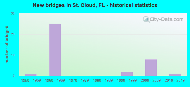
- New bridges - historical statistics
- 11950-1959
- 251960-1969
- 21990-1999
- 82000-2009
- 12010-2019
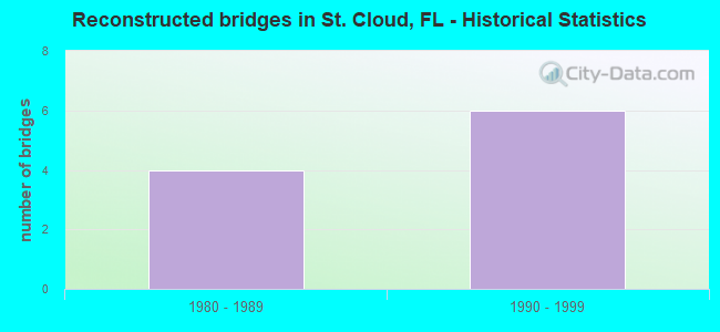
- Reconstructed bridges - Historical Statistics
- 41980-1989
- 61990-1999
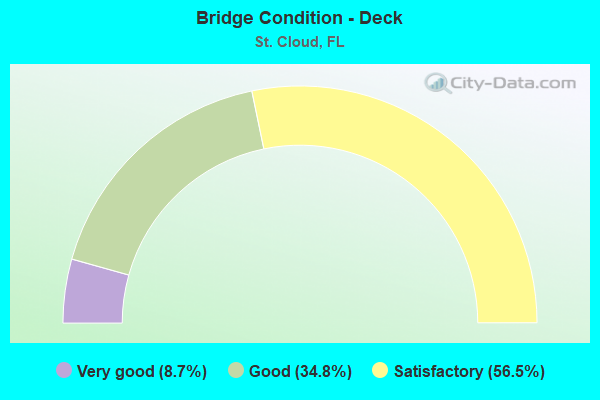
- Bridge Condition - Deck
- 8.7%Very good
- 34.8%Good
- 56.5%Satisfactory
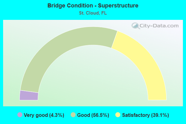
- Bridge Condition - Superstructure
- 4.3%Very good
- 56.5%Good
- 39.1%Satisfactory
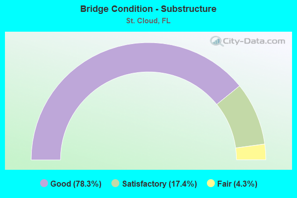
- Bridge Condition - Substructure
- 78.3%Good
- 17.4%Satisfactory
- 4.3%Fair
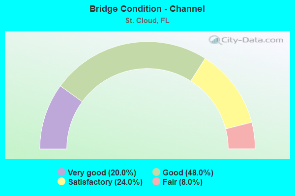
- Bridge Condition - Channel
- 20.0%Very good
- 48.0%Good
- 24.0%Satisfactory
- 8.0%Fair
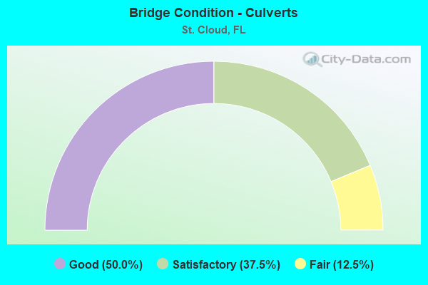
- Bridge Condition - Culverts
- 50.0%Good
- 37.5%Satisfactory
- 12.5%Fair
Find on map >> Show street view
Structure Number: 920026, Location: 1 MI NORTH OF US 441 (Lat: 28.278833, Lng: -81.336844), Route carried "on" structure: County highway 523, Year Built: 1963, Status: Open, Structure Length: 6.13m (20.11ft), Average Daily Traffic: 43,100 (year 2020), Truck Traffic: 12%, Average Future Daily Traffic: 74,778 (year 2042), Design Load: H 20, Features Intersected: SR 91 TPK
Minimum Vertical Clearance: 30+ m (98+ ft), Kilometerpoint: 56.483, Lanes on structure: 2, Lanes under structure: 4, Owner: State Toll Authority, Approaching Roadway Width: 8.5m (27.9ft), Skew: 2 degrees, Material/Design: Prestressed concrete, Design/Construction: Stringer/Multi-beam, Number Of Spans In Main Unit: 4, Length of Maximum Span: 18.4m (60.4ft), Curb or Sidewalk Widths: Left: 0.6m (2.0ft), Right: 0.6m (2.0ft), Curb-To-Curb Width: 8.5m (27.9ft), Out-to-Out Width: 10.3m (33.8ft)
Condition: Deck: Good, Superstructure: Good, Substructure: Good, Operating Rating: 38.7 metric tons, Method Used To Determine Operating Rating: Load and Resistance Factor (LRFR), Inventory Rating: 31.3 metric tons, Method Used To Determine Inventory Rating: Load and Resistance Factor (LRFR), Structural Evaluation: Better than present minimum criteria, Deck Geometry: Meets minimum limits, Underclear: High priority of corrective action, Approach Roadway Alignment: Equal to present desirable criteria, Designated Inspection Frequency: Every 24 months, Inspection Date: September 2021, Deck Structure Type: Concrete Cast-file-Place
Find on map >> Show street view
Structure Number: 920044, Location: 2.5MI S OF KISS. INTRCH (Lat: 28.255917, Lng: -81.331136), Route carried "on" structure: County highway 525, Year Built: 1963, Status: Open, Structure Length: 7.80m (25.59ft), Average Daily Traffic: 23,500 (year 2020), Truck Traffic: 2%, Average Future Daily Traffic: 40,772 (year 2042), Design Load: H 20, Features Intersected: SR 91 TPK
Minimum Vertical Clearance: 30+ m (98+ ft), Kilometerpoint: 8.621, Lanes on structure: 2, Lanes under structure: 4, Owner: State Toll Authority, Approaching Roadway Width: 12.8m (42.0ft), Skew: 4 degrees, Material/Design: Prestressed concrete, Design/Construction: Stringer/Multi-beam, Number Of Spans In Main Unit: 4, Length of Maximum Span: 24.1m (79.1ft), Curb or Sidewalk Widths: Left: 0.6m (2.0ft), Right: 0.6m (2.0ft), Curb-To-Curb Width: 8.5m (27.9ft), Out-to-Out Width: 10.3m (33.8ft)
Condition: Deck: Satisfactory, Superstructure: Good, Substructure: Good, Operating Rating: 44.9 metric tons, Method Used To Determine Operating Rating: Load and Resistance Factor (LRFR), Inventory Rating: 38.5 metric tons, Method Used To Determine Inventory Rating: Load and Resistance Factor (LRFR), Structural Evaluation: Better than present minimum criteria, Deck Geometry: Meets minimum limits, Underclear: High priority of corrective action, Approach Roadway Alignment: Equal to present desirable criteria, Designated Inspection Frequency: Every 24 months, Inspection Date: September 2021, Deck Structure Type: Concrete Cast-file-Place
Find on map >> Show street view
Structure Number: 920068, Location: 3.9MI S OF 3 LAKES TOLL P (Lat: 28.128036, Lng: -81.288383), Route carried "on" structure: State highway 91, Year Built: 1964, Status: Open, Structure Length: 0.76m (2.49ft), Average Daily Traffic: 27,800 (year 2020), Truck Traffic: 12%, Average Future Daily Traffic: 48,233 (year 2042), Design Load: HS 20, Features Intersected: OUTFALL CANAL
Minimum Vertical Clearance: 30+ m (98+ ft), Kilometerpoint: 38.875, Lanes on structure: 4, Base Highway Network: Yes, Toll: On toll road, Owner: State Toll Authority, Approaching Roadway Width: 26.5m (86.9ft), Skew: 10 degrees, Material/Design: Concrete, Design/Construction: Culvert, Number Of Spans In Main Unit: 3, Length of Maximum Span: 2.4m (7.9ft)
Condition: Channel: Good, Culverts: Satisfactory, Operating Rating: 65.5 metric tons, Method Used To Determine Operating Rating: Load Factor (LF), Inventory Rating: 39.3 metric tons, Method Used To Determine Inventory Rating: Load Factor (LF), Structural Evaluation: Equal to present minimum criteria, Waterway Adequacy: Better than present minimum criteria, Approach Roadway Alignment: Equal to present desirable criteria, Designated Inspection Frequency: Every 24 months, Inspection Date: September 2021
Find on map >> Show street view
Structure Number: 920069, Location: 2.7MI S OF 3 LAKES TOLL (Lat: 28.142883, Lng: -81.294025), Route carried "on" structure: State highway 91, Year Built: 1964, Status: Open, Structure Length: 0.77m (2.53ft), Average Daily Traffic: 27,800 (year 2020), Truck Traffic: 12%, Average Future Daily Traffic: 48,233 (year 2042), Design Load: HS 20, Features Intersected: OUTFALL CANAL
Minimum Vertical Clearance: 30+ m (98+ ft), Kilometerpoint: 40.613, Lanes on structure: 4, Base Highway Network: Yes, Toll: On toll road, Owner: State Toll Authority, Approaching Roadway Width: 25.4m (83.3ft), Skew: 10 degrees, Material/Design: Concrete, Design/Construction: Culvert, Number Of Spans In Main Unit: 3, Length of Maximum Span: 2.4m (7.9ft)
Condition: Channel: Good, Culverts: Satisfactory, Operating Rating: 45.3 metric tons, Method Used To Determine Operating Rating: Load Factor (LF), Inventory Rating: 27.1 metric tons, Method Used To Determine Inventory Rating: Load Factor (LF), Structural Evaluation: Equal to present minimum criteria, Waterway Adequacy: Better than present minimum criteria, Approach Roadway Alignment: Equal to present desirable criteria, Designated Inspection Frequency: Every 24 months, Inspection Date: September 2021
Find on map >> Show street view
Structure Number: 92007, Location: 1 MILE S OF 3 LAKES TOLL (Lat: 28.167250, Lng: -81.301378), Route carried "on" structure: State highway 91, Year Built: 1964, Year Reconstructed: 1998, Status: Open, Structure Length: 2.38m (7.81ft), Average Daily Traffic: 13,900 (year 2020), Truck Traffic: 12%, Average Future Daily Traffic: 24,116 (year 2042), Design Load: H 20, Features Intersected: FANNY BASS CREEK
Minimum Vertical Clearance: 30+ m (98+ ft), Kilometerpoint: 43.406, Lanes on structure: 2, Base Highway Network: Yes, Toll: On toll road, Owner: State Toll Authority, Approaching Roadway Width: 11.4m (37.4ft), Material/Design: Prestressed concrete, Design/Construction: Slab, Number Of Spans In Main Unit: 3, Length of Maximum Span: 8.0m (26.2ft), Curb-To-Curb Width: 12.2m (40.0ft), Out-to-Out Width: 13.1m (43.0ft)
Condition: Deck: Satisfactory, Superstructure: Satisfactory, Substructure: Good, Channel: Fair, Operating Rating: 65.2 metric tons, Method Used To Determine Operating Rating: Load and Resistance Factor (LRFR), Inventory Rating: 58.2 metric tons, Method Used To Determine Inventory Rating: Load and Resistance Factor (LRFR), Structural Evaluation: Equal to present minimum criteria, Deck Geometry: Better than present minimum criteria, Waterway Adequacy: Equal to present desirable criteria, Approach Roadway Alignment: Equal to present desirable criteria, Length Of Structure Improvement: 2.38m (7.81ft), Designated Inspection Frequency: Every 24 months, Inspection Date: September 2021, Bridge Improvement Cost: $500,000, Roadway Improvement Cost: $40,000, Total Project Cost: $500,000, Deck Structure Type: Concrete Precast Panels, Wearing Surface/Protective System: Wearing Surface: Bituminous
Find on map >> Show street view
Structure Number: 920072, Location: 0.7MI N OF 3 LKS TOLL PLZ (Lat: 28.190972, Lng: -81.304942), Route carried "on" structure: State highway 91, Year Built: 1964, Year Reconstructed: 1996, Status: Open, Structure Length: 2.40m (7.87ft), Average Daily Traffic: 13,900 (year 2020), Truck Traffic: 12%, Average Future Daily Traffic: 24,116 (year 2042), Design Load: H 20, Features Intersected: GATOR BAY BRANCH
Minimum Vertical Clearance: 30+ m (98+ ft), Kilometerpoint: 46.058, Lanes on structure: 2, Base Highway Network: Yes, Toll: On toll road, Owner: State Toll Authority, Approaching Roadway Width: 11.4m (37.4ft), Material/Design: Prestressed concrete, Design/Construction: Slab, Number Of Spans In Main Unit: 3, Length of Maximum Span: 8.0m (26.2ft), Curb-To-Curb Width: 12.2m (40.0ft), Out-to-Out Width: 13.3m (43.6ft)
Condition: Deck: Satisfactory, Superstructure: Satisfactory, Substructure: Good, Channel: Fair, Operating Rating: 65.2 metric tons, Method Used To Determine Operating Rating: Load and Resistance Factor (LRFR), Inventory Rating: 58.2 metric tons, Method Used To Determine Inventory Rating: Load and Resistance Factor (LRFR), Structural Evaluation: Equal to present minimum criteria, Deck Geometry: Better than present minimum criteria, Waterway Adequacy: Equal to present desirable criteria, Approach Roadway Alignment: Equal to present desirable criteria, Designated Inspection Frequency: Every 24 months, Inspection Date: September 2021, Deck Structure Type: Concrete Precast Panels, Wearing Surface/Protective System: Wearing Surface: Bituminous, Membrane: Preformed Fabric
Find on map >> Show street view
Structure Number: 920073, Location: 6.4 MI S OF KISS INTX (Lat: 28.205650, Lng: -81.307128), Route carried "on" structure: State highway 91, Year Built: 1964, Year Reconstructed: 1996, Status: Open, Structure Length: 2.65m (8.69ft), Average Daily Traffic: 13,900 (year 2020), Truck Traffic: 12%, Average Future Daily Traffic: 24,116 (year 2042), Design Load: H 20, Features Intersected: WPA CANAL
Minimum Vertical Clearance: 30+ m (98+ ft), Kilometerpoint: 47.696, Lanes on structure: 2, Base Highway Network: Yes, Toll: On toll road, Owner: State Toll Authority, Approaching Roadway Width: 11.4m (37.4ft), Skew: 1 degrees, Material/Design: Prestressed concrete, Design/Construction: Slab, Number Of Spans In Main Unit: 3, Length of Maximum Span: 9.0m (29.5ft), Curb-To-Curb Width: 12.2m (40.0ft), Out-to-Out Width: 13.1m (43.0ft)
Condition: Deck: Satisfactory, Superstructure: Satisfactory, Substructure: Good, Channel: Satisfactory, Operating Rating: 55.7 metric tons, Method Used To Determine Operating Rating: Load and Resistance Factor (LRFR), Inventory Rating: 48.1 metric tons, Method Used To Determine Inventory Rating: Load and Resistance Factor (LRFR), Structural Evaluation: Equal to present minimum criteria, Deck Geometry: Better than present minimum criteria, Waterway Adequacy: Equal to present desirable criteria, Approach Roadway Alignment: Equal to present desirable criteria, Designated Inspection Frequency: Every 24 months, Inspection Date: September 2021, Deck Structure Type: Concrete Precast Panels, Wearing Surface/Protective System: Wearing Surface: Bituminous, Membrane: Preformed Fabric
Find on map >> Show street view
Structure Number: 920074, Location: 1.0 MI S OF US 441 (Lat: 28.251564, Lng: -81.329856), Route carried "on" structure: State highway 91, Year Built: 1963, Year Reconstructed: 1991, Status: Open, Structure Length: 7.76m (25.46ft), Average Daily Traffic: 22,150 (year 2020), Truck Traffic: 12%, Average Future Daily Traffic: 38,430 (year 2042), Design Load: H 20, Features Intersected: C 31 CANAL
Minimum Vertical Clearance: 30+ m (98+ ft), Kilometerpoint: 53.350, Lanes on structure: 2, Base Highway Network: Yes, Toll: On toll road, Owner: State Toll Authority, Approaching Roadway Width: 11.4m (37.4ft), Skew: 4 degrees, Material/Design: Prestressed concrete, Design/Construction: Stringer/Multi-beam, Number Of Spans In Main Unit: 5, Length of Maximum Span: 17.2m (56.4ft), Curb-To-Curb Width: 12.2m (40.0ft), Out-to-Out Width: 13.1m (43.0ft)
Condition: Deck: Satisfactory, Superstructure: Good, Substructure: Satisfactory, Channel: Very good, Operating Rating: 48.3 metric tons, Method Used To Determine Operating Rating: Load and Resistance Factor (LRFR), Inventory Rating: 37.2 metric tons, Method Used To Determine Inventory Rating: Load and Resistance Factor (LRFR), Structural Evaluation: Equal to present minimum criteria, Deck Geometry: Better than present minimum criteria, Waterway Adequacy: Equal to present desirable criteria, Approach Roadway Alignment: Equal to present desirable criteria, Designated Inspection Frequency: Every 24 months, Underwater Inspection Frequency: Every 23 months, Inspection Date: September 2021, Underwater Inspection Date: October 2021, Deck Structure Type: Concrete Cast-file-Place
Find on map >> Show street view
Structure Number: 920078, Location: 1.9 MI SOUTH OF KISS INTX (Lat: 28.265467, Lng: -81.333425), Route carried "on" structure: State highway 91, Year Built: 1963, Year Reconstructed: 1991, Status: Open, Structure Length: 9.39m (30.81ft), Average Daily Traffic: 22,150 (year 2020), Truck Traffic: 12%, Average Future Daily Traffic: 38,430 (year 2042), Design Load: H 20, Features Intersected: US 441 SR 500
Minimum Vertical Clearance: 30+ m (98+ ft), Kilometerpoint: 54.916, Lanes on structure: 2, Lanes under structure: 6, Base Highway Network: Yes, Toll: On toll road, Owner: State Toll Authority, Approaching Roadway Width: 12.3m (40.4ft), Skew: 6 degrees, Material/Design: Prestressed concrete, Design/Construction: Stringer/Multi-beam, Number Of Spans In Main Unit: 4, Length of Maximum Span: 28.3m (92.8ft), Curb-To-Curb Width: 12.3m (40.4ft), Out-to-Out Width: 13.2m (43.3ft)
Condition: Deck: Satisfactory, Superstructure: Good, Substructure: Good, Operating Rating: 47.0 metric tons, Method Used To Determine Operating Rating: Load and Resistance Factor (LRFR), Inventory Rating: 36.3 metric tons, Method Used To Determine Inventory Rating: Load and Resistance Factor (LRFR), Structural Evaluation: Better than present minimum criteria, Deck Geometry: Better than present minimum criteria, Underclear: High priority of corrective action, Approach Roadway Alignment: Equal to present desirable criteria, Designated Inspection Frequency: Every 24 months, Inspection Date: September 2021, Deck Structure Type: Concrete Cast-file-Place
Find on map >> Show street view
Structure Number: 920093, Location: 2MI S OF 3 LAKES TOLL PL (Lat: 28.152683, Lng: -81.297747), Route carried "on" structure: State highway 91, Year Built: 1964, Status: Open, Structure Length: 0.63m (2.07ft), Average Daily Traffic: 27,800 (year 2020), Truck Traffic: 12%, Average Future Daily Traffic: 48,233 (year 2042), Design Load: HS 20, Features Intersected: OUTFALL DITCH
Minimum Vertical Clearance: 30+ m (98+ ft), Kilometerpoint: 41.756, Lanes on structure: 4, Base Highway Network: Yes, Toll: On toll road, Owner: State Toll Authority, Approaching Roadway Width: 25.5m (83.7ft), Skew: 10 degrees, Material/Design: Concrete, Design/Construction: Culvert, Number Of Spans In Main Unit: 2, Length of Maximum Span: 3.0m (9.8ft)
Condition: Channel: Good, Culverts: Satisfactory, Operating Rating: 55.6 metric tons, Method Used To Determine Operating Rating: Load Factor (LF), Inventory Rating: 33.4 metric tons, Method Used To Determine Inventory Rating: Load Factor (LF), Structural Evaluation: Equal to present minimum criteria, Waterway Adequacy: Equal to present desirable criteria, Approach Roadway Alignment: Equal to present desirable criteria, Designated Inspection Frequency: Every 24 months, Inspection Date: September 2021
Find on map >> Show street view
Structure Number: 92013, Location: 1 MILE S OF 3 LAKES TOLL (Lat: 28.167272, Lng: -81.301178), Route carried "on" structure: State highway 91, Year Built: 1964, Year Reconstructed: 1998, Status: Open, Structure Length: 2.38m (7.81ft), Average Daily Traffic: 13,900 (year 2020), Truck Traffic: 12%, Average Future Daily Traffic: 24,116 (year 2042), Design Load: H 20, Features Intersected: FANNY BASS CREEK
Minimum Vertical Clearance: 30+ m (98+ ft), Kilometerpoint: 43.406, Lanes on structure: 2, Base Highway Network: Yes, Toll: On toll road, Owner: State Toll Authority, Approaching Roadway Width: 11.4m (37.4ft), Material/Design: Prestressed concrete, Design/Construction: Slab, Number Of Spans In Main Unit: 3, Length of Maximum Span: 8.0m (26.2ft), Curb-To-Curb Width: 12.2m (40.0ft), Out-to-Out Width: 13.1m (43.0ft)
Condition: Deck: Satisfactory, Superstructure: Satisfactory, Substructure: Good, Channel: Satisfactory, Operating Rating: 65.2 metric tons, Method Used To Determine Operating Rating: Load and Resistance Factor (LRFR), Inventory Rating: 58.2 metric tons, Method Used To Determine Inventory Rating: Load and Resistance Factor (LRFR), Structural Evaluation: Equal to present minimum criteria, Deck Geometry: Better than present minimum criteria, Waterway Adequacy: Equal to present desirable criteria, Approach Roadway Alignment: Equal to present desirable criteria, Length Of Structure Improvement: 2.38m (7.81ft), Designated Inspection Frequency: Every 24 months, Inspection Date: September 2021, Bridge Improvement Cost: $500,000, Roadway Improvement Cost: $40,000, Total Project Cost: $500,000, Deck Structure Type: Concrete Precast Panels, Wearing Surface/Protective System: Wearing Surface: Bituminous
Find on map >> Show street view
Structure Number: 920131, Location: 0.5 MI S OF 3 LAKES TOLL (Lat: 28.173444, Lng: -81.302183), Route carried "on" structure: County highway , Year Built: 1964, Status: Open, Structure Length: 5.68m (18.64ft), Average Daily Traffic: 27,800 (year 2020), Truck Traffic: 12%, Average Future Daily Traffic: 48,233 (year 2042), Design Load: H 20, Features Intersected: SR 91 TPK, Facility Carried by Structure: FRIARS COVE 235.9
Minimum Vertical Clearance: 30+ m (98+ ft), Kilometerpoint: 44.106, Lanes on structure: 2, Lanes under structure: 4, Owner: State Toll Authority, Approaching Roadway Width: 7.0m (23.0ft), Material/Design: Prestressed concrete, Design/Construction: Stringer/Multi-beam, Number Of Spans In Main Unit: 4, Length of Maximum Span: 17.1m (56.1ft), Curb or Sidewalk Widths: Left: 0.6m (2.0ft), Right: 0.6m (2.0ft), Curb-To-Curb Width: 8.5m (27.9ft), Out-to-Out Width: 10.3m (33.8ft)
Condition: Deck: Satisfactory, Superstructure: Good, Substructure: Good, Operating Rating: 60.1 metric tons, Method Used To Determine Operating Rating: Load and Resistance Factor (LRFR), Inventory Rating: 42.1 metric tons, Method Used To Determine Inventory Rating: Load and Resistance Factor (LRFR), Structural Evaluation: Better than present minimum criteria, Deck Geometry: High priority of replacement, Underclear: Meets minimum limits, Approach Roadway Alignment: Equal to present desirable criteria, Designated Inspection Frequency: Every 24 months, Inspection Date: September 2021, Deck Structure Type: Concrete Cast-file-Place
Find on map >> Show street view
Structure Number: 920132, Location: 0.7MI N OF 3 LKS TOLL PLZ (Lat: 28.190981, Lng: -81.304736), Route carried "on" structure: State highway 91, Year Built: 1964, Year Reconstructed: 1996, Status: Open, Structure Length: 2.40m (7.87ft), Average Daily Traffic: 13,900 (year 2020), Truck Traffic: 12%, Average Future Daily Traffic: 24,116 (year 2042), Design Load: H 20, Features Intersected: GATOR BAY BRANCH
Minimum Vertical Clearance: 30+ m (98+ ft), Kilometerpoint: 46.058, Lanes on structure: 2, Base Highway Network: Yes, Toll: On toll road, Owner: State Toll Authority, Approaching Roadway Width: 11.4m (37.4ft), Material/Design: Prestressed concrete, Design/Construction: Slab, Number Of Spans In Main Unit: 3, Length of Maximum Span: 8.0m (26.2ft), Curb-To-Curb Width: 12.2m (40.0ft), Out-to-Out Width: 13.3m (43.6ft)
Condition: Deck: Satisfactory, Superstructure: Satisfactory, Substructure: Good, Channel: Good, Operating Rating: 65.2 metric tons, Method Used To Determine Operating Rating: Load and Resistance Factor (LRFR), Inventory Rating: 58.2 metric tons, Method Used To Determine Inventory Rating: Load and Resistance Factor (LRFR), Structural Evaluation: Equal to present minimum criteria, Deck Geometry: Better than present minimum criteria, Waterway Adequacy: Equal to present desirable criteria, Approach Roadway Alignment: Equal to present desirable criteria, Designated Inspection Frequency: Every 24 months, Inspection Date: September 2021, Deck Structure Type: Concrete Precast Panels, Wearing Surface/Protective System: Wearing Surface: Bituminous, Membrane: Preformed Fabric
Find on map >> Show street view
Structure Number: 920133, Location: 6.4 MI S OF KISS INTX (Lat: 28.205697, Lng: -81.306925), Route carried "on" structure: State highway 91, Year Built: 1964, Year Reconstructed: 1996, Status: Open, Structure Length: 2.65m (8.69ft), Average Daily Traffic: 13,900 (year 2020), Truck Traffic: 12%, Average Future Daily Traffic: 24,116 (year 2042), Design Load: H 20, Features Intersected: WPA CANAL
Minimum Vertical Clearance: 30+ m (98+ ft), Kilometerpoint: 47.701, Lanes on structure: 2, Base Highway Network: Yes, Toll: On toll road, Owner: State Toll Authority, Approaching Roadway Width: 11.4m (37.4ft), Skew: 1 degrees, Material/Design: Prestressed concrete, Design/Construction: Slab, Number Of Spans In Main Unit: 3, Length of Maximum Span: 9.0m (29.5ft), Curb-To-Curb Width: 12.2m (40.0ft), Out-to-Out Width: 13.1m (43.0ft)
Condition: Deck: Satisfactory, Superstructure: Satisfactory, Substructure: Good, Channel: Satisfactory, Operating Rating: 55.7 metric tons, Method Used To Determine Operating Rating: Load and Resistance Factor (LRFR), Inventory Rating: 48.1 metric tons, Method Used To Determine Inventory Rating: Load and Resistance Factor (LRFR), Structural Evaluation: Equal to present minimum criteria, Deck Geometry: Better than present minimum criteria, Waterway Adequacy: Equal to present desirable criteria, Approach Roadway Alignment: Equal to present desirable criteria, Designated Inspection Frequency: Every 24 months, Inspection Date: September 2021, Deck Structure Type: Concrete Precast Panels, Wearing Surface/Protective System: Wearing Surface: Bituminous, Membrane: Preformed Fabric
Find on map >> Show street view
Structure Number: 920134, Location: 1.9 MI SOUTH OF KISS INTX (Lat: 28.265203, Lng: -81.333164), Route carried "on" structure: State highway 91, Year Built: 1963, Year Reconstructed: 1991, Status: Open, Structure Length: 9.39m (30.81ft), Average Daily Traffic: 22,150 (year 2020), Truck Traffic: 12%, Average Future Daily Traffic: 38,430 (year 2042), Design Load: H 20, Features Intersected: US 441 SR 500
Minimum Vertical Clearance: 30+ m (98+ ft), Kilometerpoint: 54.882, Lanes on structure: 2, Lanes under structure: 4, Base Highway Network: Yes, Toll: On toll road, Owner: State Toll Authority, Approaching Roadway Width: 12.4m (40.7ft), Skew: 5 degrees, Material/Design: Prestressed concrete, Design/Construction: Stringer/Multi-beam, Number Of Spans In Main Unit: 4, Length of Maximum Span: 28.6m (93.8ft), Curb-To-Curb Width: 12.3m (40.4ft), Out-to-Out Width: 13.2m (43.3ft)
Condition: Deck: Satisfactory, Superstructure: Satisfactory, Substructure: Good, Operating Rating: 47.0 metric tons, Method Used To Determine Operating Rating: Load and Resistance Factor (LRFR), Inventory Rating: 36.3 metric tons, Method Used To Determine Inventory Rating: Load and Resistance Factor (LRFR), Structural Evaluation: Equal to present minimum criteria, Deck Geometry: Better than present minimum criteria, Underclear: High priority of corrective action, Approach Roadway Alignment: Equal to present desirable criteria, Designated Inspection Frequency: Every 24 months, Inspection Date: September 2021, Deck Structure Type: Concrete Cast-file-Place
Find on map >> Show street view
Structure Number: 92014, Location: 1 MI S OF US 441 (Lat: 28.251853, Lng: -81.329736), Route carried "on" structure: State highway 91, Year Built: 1963, Year Reconstructed: 1991, Status: Open, Structure Length: 7.76m (25.46ft), Average Daily Traffic: 22,150 (year 2020), Truck Traffic: 12%, Average Future Daily Traffic: 38,430 (year 2042), Design Load: H 20, Features Intersected: C 31 CANAL
Minimum Vertical Clearance: 30+ m (98+ ft), Kilometerpoint: 53.371, Lanes on structure: 2, Base Highway Network: Yes, Toll: On toll road, Owner: State Toll Authority, Approaching Roadway Width: 11.4m (37.4ft), Skew: 4 degrees, Material/Design: Prestressed concrete, Design/Construction: Stringer/Multi-beam, Number Of Spans In Main Unit: 5, Length of Maximum Span: 17.2m (56.4ft), Curb-To-Curb Width: 12.2m (40.0ft), Out-to-Out Width: 13.1m (43.0ft)
Condition: Deck: Satisfactory, Superstructure: Good, Substructure: Satisfactory, Channel: Very good, Operating Rating: 48.3 metric tons, Method Used To Determine Operating Rating: Load and Resistance Factor (LRFR), Inventory Rating: 37.2 metric tons, Method Used To Determine Inventory Rating: Load and Resistance Factor (LRFR), Structural Evaluation: Equal to present minimum criteria, Deck Geometry: Better than present minimum criteria, Waterway Adequacy: Equal to present desirable criteria, Approach Roadway Alignment: Equal to present desirable criteria, Designated Inspection Frequency: Every 24 months, Underwater Inspection Frequency: Every 23 months, Inspection Date: September 2021, Underwater Inspection Date: October 2021, Deck Structure Type: Concrete Cast-file-Place
Find on map >> Show street view
Structure Number: 92019, Location: US-192 - Alligator Creek (Lat: 28.235114, Lng: -81.189747), Route carried "on" structure: US 530, Year Built: 2008, Status: Open, Structure Length: 3.99m (13.09ft), Average Daily Traffic: 9,350 (year 2020), Truck Traffic: 9%, Average Future Daily Traffic: 16,222 (year 2042), Design Load: HL 93, Features Intersected: Alligator Creek, Facility Carried by Structure: US-192 WB
Minimum Vertical Clearance: 30+ m (98+ ft), Kilometerpoint: 23.648, Lanes on structure: 2, Base Highway Network: Yes, Owner: State Highway Agency, Approaching Roadway Width: 10.4m (34.1ft), Material/Design: Concrete, Design/Construction: Slab, Number Of Spans In Main Unit: 5, Length of Maximum Span: 8.5m (27.9ft), Curb or Sidewalk Widths: Left: 1.8m (5.9ft), Right: 0.0m, Curb-To-Curb Width: 10.4m (34.1ft), Out-to-Out Width: 15.2m (49.9ft)
Condition: Deck: Good, Superstructure: Good, Substructure: Good, Channel: Very good, Operating Rating: 48.0 metric tons, Method Used To Determine Operating Rating: Load and Resistance Factor (LRFR), Inventory Rating: 36.9 metric tons, Method Used To Determine Inventory Rating: Load and Resistance Factor (LRFR), Structural Evaluation: Better than present minimum criteria, Deck Geometry: Somewhat better than minimum adequacy, Waterway Adequacy: Equal to present minimum criteria, Approach Roadway Alignment: Equal to present desirable criteria, Designated Inspection Frequency: Every 24 months, Underwater Inspection Frequency: Every 24 months, Inspection Date: May 2020, Underwater Inspection Date: May 2020, Deck Structure Type: Concrete Cast-file-Place, Wearing Surface/Protective System: Wearing Surface: Monolithic Concrete
Find on map >> Show street view
Structure Number: 920191, Location: US-192EB -Alligator Creek (Lat: 28.234964, Lng: -81.189892), Route carried "on" structure: US 530, Year Built: 2008, Status: Open, Structure Length: 3.99m (13.09ft), Average Daily Traffic: 9,350 (year 2020), Truck Traffic: 9%, Average Future Daily Traffic: 16,222 (year 2042), Design Load: HL 93, Features Intersected: Alligator Creek, Facility Carried by Structure: US-192 EB
Minimum Vertical Clearance: 30+ m (98+ ft), Kilometerpoint: 23.648, Lanes on structure: 2, Base Highway Network: Yes, Owner: State Highway Agency, Approaching Roadway Width: 10.4m (34.1ft), Material/Design: Concrete, Design/Construction: Slab, Number Of Spans In Main Unit: 5, Length of Maximum Span: 8.5m (27.9ft), Curb-To-Curb Width: 10.4m (34.1ft), Out-to-Out Width: 13.1m (43.0ft)
Condition: Deck: Good, Superstructure: Good, Substructure: Good, Channel: Good, Operating Rating: 50.3 metric tons, Method Used To Determine Operating Rating: Load and Resistance Factor (LRFR), Inventory Rating: 38.8 metric tons, Method Used To Determine Inventory Rating: Load and Resistance Factor (LRFR), Structural Evaluation: Better than present minimum criteria, Deck Geometry: Somewhat better than minimum adequacy, Waterway Adequacy: Equal to present minimum criteria, Approach Roadway Alignment: Equal to present desirable criteria, Designated Inspection Frequency: Every 24 months, Underwater Inspection Frequency: Every 24 months, Inspection Date: May 2020, Underwater Inspection Date: May 2020, Deck Structure Type: Concrete Cast-file-Place, Wearing Surface/Protective System: Wearing Surface: Monolithic Concrete
Find on map >> Show street view
Structure Number: 920204, Location: US-192 - St.Cloud Canal (Lat: 28.257306, Lng: -81.322444), Route carried "on" structure: US 192, Year Built: 2017, Status: Open, Structure Length: 5.09m (16.70ft), Average Daily Traffic: 48,000 (year 2020), Truck Traffic: 6%, Average Future Daily Traffic: 83,280 (year 2042), Design Load: HL 93, Features Intersected: St. Cloud Canal
Minimum Vertical Clearance: 30+ m (98+ ft), Kilometerpoint: 10.033, Lanes on structure: 6, Base Highway Network: Yes, Owner: State Highway Agency, Approaching Roadway Width: 36.6m (120.1ft), Skew: 31 degrees, Material/Design: Concrete, Design/Construction: Stringer/Multi-beam, Number Of Spans In Main Unit: 3, Length of Maximum Span: 16.8m (55.1ft), Curb or Sidewalk Widths: Left: 1.5m (4.9ft), Right: 1.5m (4.9ft), Curb-To-Curb Width: 36.6m (120.1ft), Out-to-Out Width: 41.8m (137.1ft)
Condition: Deck: Very good, Superstructure: Satisfactory, Substructure: Good, Channel: Very good, Operating Rating: 50.0 metric tons, Method Used To Determine Operating Rating: Load and Resistance Factor (LRFR), Inventory Rating: 38.6 metric tons, Method Used To Determine Inventory Rating: Load and Resistance Factor (LRFR), Structural Evaluation: Equal to present minimum criteria, Deck Geometry: Superior to present desirable criteria, Waterway Adequacy: Equal to present desirable criteria, Approach Roadway Alignment: Equal to present desirable criteria, Designated Inspection Frequency: Every 24 months, Underwater Inspection Frequency: Every 24 months, Inspection Date: June 2021, Underwater Inspection Date: June 2021, Deck Structure Type: Concrete Cast-file-Place, Wearing Surface/Protective System: Wearing Surface: Monolithic Concrete
Find on map >> Show street view
Structure Number: 924037, Location: 100ft N Brown Chapel Rd (Lat: 28.266525, Lng: -81.309406), Route carried "on" structure: County highway 523, Year Built: 1960, Status: Open, Structure Length: 3.81m (12.50ft), Average Daily Traffic: 20,500 (year 2020), Truck Traffic: 1%, Average Future Daily Traffic: 34,850 (year 2042), Design Load: H 20, Features Intersected: St Cloud Canal C-31, Facility Carried by Structure: Lake Shore Dr
Minimum Vertical Clearance: 30+ m (98+ ft), Kilometerpoint: 59.782, Lanes on structure: 2, Owner: County Highway Agency, Approaching Roadway Width: 6.4m (21.0ft), Material/Design: Concrete, Design/Construction: Slab, Number Of Spans In Main Unit: 5, Length of Maximum Span: 7.6m (24.9ft), Curb or Sidewalk Widths: Left: 0.2m (0.7ft), Right: 0.2m (0.7ft), Curb-To-Curb Width: 7.3m (24.0ft), Out-to-Out Width: 7.8m (25.6ft)
Condition: Deck: Good, Superstructure: Good, Substructure: Satisfactory, Channel: Good, Operating Rating: 44.9 metric tons, Method Used To Determine Operating Rating: Load Factor (LF), Inventory Rating: 26.9 metric tons, Method Used To Determine Inventory Rating: Load Factor (LF), Structural Evaluation: Equal to present minimum criteria, Deck Geometry: High priority of replacement, Waterway Adequacy: Equal to present desirable criteria, Approach Roadway Alignment: Better than present minimum criteria, Designated Inspection Frequency: Every 24 months, Underwater Inspection Frequency: Every 24 months, Inspection Date: June 2020, Underwater Inspection Date: June 2020, Deck Structure Type: Concrete Cast-file-Place
Find on map >> Show street view
Structure Number: 924045, Location: 0.8 mi S of Deer Run Road (Lat: 28.173714, Lng: -81.237056), Route carried "on" structure: County highway 534, Year Built: 1966, Status: Open, Structure Length: 3.02m (9.91ft), Average Daily Traffic: 2,300 (year 2020), Truck Traffic: 5%, Average Future Daily Traffic: 3,910 (year 2042), Design Load: HS 20, Features Intersected: Canal C-33, Facility Carried by Structure: Hickory Tree Road
Minimum Vertical Clearance: 30+ m (98+ ft), Kilometerpoint: 10.025, Lanes on structure: 2, Owner: County Highway Agency, Approaching Roadway Width: 6.1m (20.0ft), Material/Design: Prestressed concrete, Design/Construction: Slab, Number Of Spans In Main Unit: 3, Length of Maximum Span: 10.1m (33.1ft), Curb or Sidewalk Widths: Left: 0.5m (1.6ft), Right: 0.5m (1.6ft), Curb-To-Curb Width: 7.3m (24.0ft), Out-to-Out Width: 8.8m (28.9ft)
Condition: Deck: Good, Superstructure: Good, Substructure: Satisfactory, Channel: Good, Operating Rating: 49.4 metric tons, Method Used To Determine Operating Rating: Load Factor (LF), Inventory Rating: 29.6 metric tons, Method Used To Determine Inventory Rating: Load Factor (LF), Structural Evaluation: Equal to present minimum criteria, Deck Geometry: High priority of replacement, Waterway Adequacy: Equal to present desirable criteria, Approach Roadway Alignment: Equal to present desirable criteria, Designated Inspection Frequency: Every 24 months, Underwater Inspection Frequency: Every 24 months, Inspection Date: June 2020, Underwater Inspection Date: June 2020, Deck Structure Type: Concrete Precast Panels, Wearing Surface/Protective System: Wearing Surface: Bituminous
Find on map >> Show street view
Structure Number: 924049, Location: 0.1 Mi SE of Fla Turnpike (Lat: 28.253925, Lng: -81.327142), Route carried "on" structure: County highway 525, Year Built: 1957, Status: Open, Structure Length: 3.05m (10.01ft), Average Daily Traffic: 14,600 (year 2020), Truck Traffic: 23%, Average Future Daily Traffic: 24,820 (year 2042), Design Load: H 15, Features Intersected: St. Cloud Canal C-31, Facility Carried by Structure: Neptune Rd
Minimum Vertical Clearance: 30+ m (98+ ft), Kilometerpoint: 9.106, Lanes on structure: 2, Owner: County Highway Agency, Approaching Roadway Width: 6.7m (22.0ft), Material/Design: Concrete, Design/Construction: Slab, Number Of Spans In Main Unit: 5, Length of Maximum Span: 6.1m (20.0ft), Curb-To-Curb Width: 7.3m (24.0ft), Out-to-Out Width: 7.8m (25.6ft)
Condition: Deck: Good, Superstructure: Good, Substructure: Fair, Channel: Satisfactory, Operating Rating: 29.5 metric tons, Method Used To Determine Operating Rating: Load and Resistance Factor (LRFR), Inventory Rating: 22.7 metric tons, Method Used To Determine Inventory Rating: Load and Resistance Factor (LRFR), Structural Evaluation: Somewhat better than minimum adequacy, Deck Geometry: High priority of replacement, Waterway Adequacy: Equal to present desirable criteria, Approach Roadway Alignment: Better than present minimum criteria, Designated Inspection Frequency: Every 24 months, Underwater Inspection Frequency: Every 24 months, Inspection Date: June 2020, Underwater Inspection Date: June 2020, Deck Structure Type: Concrete Cast-file-Place
Find on map >> Show street view
Structure Number: 924113, Location: 3.1 mi N of US-192 441 (Lat: 28.272844, Lng: -81.185422), Route carried "on" structure: County highway 532, Year Built: 1965, Status: Open, Structure Length: 2.97m (9.74ft), Average Daily Traffic: 4,100 (year 2020), Truck Traffic: 6%, Average Future Daily Traffic: 7,114 (year 2042), Design Load: H 20, Features Intersected: Cantee Creek Canal
Minimum Vertical Clearance: 30+ m (98+ ft), Kilometerpoint: 5.005, Lanes on structure: 2, Owner: County Highway Agency, Approaching Roadway Width: 7.3m (24.0ft), Material/Design: Prestressed concrete, Design/Construction: Slab, Number Of Spans In Main Unit: 3, Length of Maximum Span: 10.0m (32.8ft), Curb or Sidewalk Widths: Left: 0.7m (2.3ft), Right: 0.7m (2.3ft), Curb-To-Curb Width: 8.5m (27.9ft), Out-to-Out Width: 10.4m (34.1ft)
Condition: Deck: Good, Superstructure: Good, Substructure: Good, Channel: Very good, Operating Rating: 59.2 metric tons, Method Used To Determine Operating Rating: Allowable Stress (AS), Inventory Rating: 54.1 metric tons, Method Used To Determine Inventory Rating: Allowable Stress (AS), Structural Evaluation: Better than present minimum criteria, Deck Geometry: Meets minimum limits, Waterway Adequacy: Equal to present desirable criteria, Approach Roadway Alignment: Equal to present desirable criteria, Designated Inspection Frequency: Every 24 months, Underwater Inspection Frequency: Every 24 months, Inspection Date: July 2020, Underwater Inspection Date: July 2020, Deck Structure Type: Concrete Precast Panels, Wearing Surface/Protective System: Wearing Surface: Bituminous
Find on map >> Show street view
Structure Number: 924114, Location: 4.7 Mi. E of US-192/441 (Lat: 28.275858, Lng: -81.160117), Route carried "on" structure: County highway 532, Year Built: 1965, Status: Open, Structure Length: 3.66m (12.01ft), Average Daily Traffic: 1,550 (year 2020), Truck Traffic: 24%, Average Future Daily Traffic: 2,690 (year 2042), Design Load: H 20, Features Intersected: Canal C-32
Minimum Vertical Clearance: 30+ m (98+ ft), Kilometerpoint: 7.570, Lanes on structure: 2, Owner: County Highway Agency, Approaching Roadway Width: 7.3m (24.0ft), Material/Design: Prestressed concrete, Design/Construction: Slab, Number Of Spans In Main Unit: 3, Length of Maximum Span: 12.2m (40.0ft), Curb or Sidewalk Widths: Left: 0.7m (2.3ft), Right: 0.7m (2.3ft), Curb-To-Curb Width: 8.6m (28.2ft), Out-to-Out Width: 10.4m (34.1ft)
Condition: Deck: Satisfactory, Superstructure: Satisfactory, Substructure: Good, Channel: Good, Operating Rating: 53.1 metric tons, Method Used To Determine Operating Rating: Allowable Stress (AS), Inventory Rating: 46.5 metric tons, Method Used To Determine Inventory Rating: Allowable Stress (AS), Structural Evaluation: Equal to present minimum criteria, Deck Geometry: Somewhat better than minimum adequacy, Waterway Adequacy: Equal to present desirable criteria, Approach Roadway Alignment: Equal to present desirable criteria, Designated Inspection Frequency: Every 24 months, Underwater Inspection Frequency: Every 24 months, Inspection Date: July 2020, Underwater Inspection Date: July 2020, Deck Structure Type: Concrete Precast Panels, Wearing Surface/Protective System: Wearing Surface: Bituminous
Find on map >> Show street view
Structure Number: 924172, Location: 0.4 mi E of Pine Grove Rd (Lat: 28.258289, Lng: -81.188603), Route carried "on" structure: County highway , Year Built: 1995, Status: Open, Structure Length: 1.31m (4.30ft), Average Daily Traffic: 1,200 (year 2020), Truck Traffic: 1%, Average Future Daily Traffic: 2,082 (year 2042), Design Load: HS 20, Features Intersected: Canal C-32F, Facility Carried by Structure: Bass Highway
Minimum Vertical Clearance: 30+ m (98+ ft), Kilometerpoint: 0.571, Lanes on structure: 2, Owner: County Highway Agency, Approaching Roadway Width: 7.2m (23.6ft), Material/Design: Concrete, Design/Construction: Frame, Number Of Spans In Main Unit: 1, Length of Maximum Span: 13.1m (43.0ft), Curb-To-Curb Width: 13.3m (43.6ft), Out-to-Out Width: 13.7m (44.9ft)
Condition: Deck: Good, Superstructure: Good, Substructure: Good, Channel: Good, Operating Rating: 70.3 metric tons, Method Used To Determine Operating Rating: Load Factor (LF), Inventory Rating: 42.2 metric tons, Method Used To Determine Inventory Rating: Load Factor (LF), Structural Evaluation: Better than present minimum criteria, Deck Geometry: Better than present minimum criteria, Waterway Adequacy: Equal to present desirable criteria, Approach Roadway Alignment: Equal to present desirable criteria, Designated Inspection Frequency: Every 24 months, Underwater Inspection Frequency: Every 24 months, Inspection Date: July 2020, Underwater Inspection Date: July 2020, Deck Structure Type: Concrete Precast Panels, Wearing Surface/Protective System: Wearing Surface: Bituminous
Find on map >> Show street view
Structure Number: 924182, Location: 3.3 MI South of US-192 (Lat: 28.221056, Lng: -81.317028), Route carried "on" structure: County highway 525, Year Built: 2006, Status: Open, Structure Length: 6.16m (20.21ft), Average Daily Traffic: 2,400 (year 2021), Truck Traffic: 24%, Average Future Daily Traffic: 4,080 (year 2042), Design Load: HS 20+Mod, Features Intersected: SR-91 TPK, Facility Carried by Structure: Kissimmee Pk Rd
Minimum Vertical Clearance: 30+ m (98+ ft), Kilometerpoint: 8.621, Lanes on structure: 3, Lanes under structure: 4, Owner: County Highway Agency, Approaching Roadway Width: 14.8m (48.6ft), Skew: 2 degrees, Material/Design: Prestressed concrete, Design/Construction: Stringer/Multi-beam, Number Of Spans In Main Unit: 2, Length of Maximum Span: 30.7m (100.7ft), Curb or Sidewalk Widths: Left: 0.0m, Right: 2.5m (8.2ft), Curb-To-Curb Width: 14.8m (48.6ft), Out-to-Out Width: 18.4m (60.4ft)
Condition: Deck: Very good, Superstructure: Very good, Substructure: Good, Operating Rating: 63.7 metric tons, Method Used To Determine Operating Rating: Load Factor (LF), Inventory Rating: 54.9 metric tons, Method Used To Determine Inventory Rating: Load Factor (LF), Structural Evaluation: Better than present minimum criteria, Deck Geometry: Equal to present minimum criteria, Underclear: Better than present minimum criteria, Approach Roadway Alignment: Equal to present minimum criteria, Designated Inspection Frequency: Every 24 months, Inspection Date: January 2021, Deck Structure Type: Concrete Cast-file-Place
Find on map >> Show street view
Structure Number: 9242, Location: 0.17 mi S of Old Canoe Ck (Lat: 28.195494, Lng: -81.292167), Route carried "on" structure: County highway 523, Year Built: 2000, Status: Open, Structure Length: 0.82m (2.69ft), Average Daily Traffic: 1,950 (year 2021), Truck Traffic: 19%, Average Future Daily Traffic: 3,384 (year 2042), Design Load: HS 20+Mod, Features Intersected: Ross Canal, Facility Carried by Structure: Canoe Creek Road
Minimum Vertical Clearance: 30+ m (98+ ft), Kilometerpoint: 50.754, Lanes on structure: 3, Owner: County Highway Agency, Approaching Roadway Width: 14.3m (46.9ft), Skew: 1 degrees, Material/Design: Concrete, Design/Construction: Culvert, Number Of Spans In Main Unit: 2, Length of Maximum Span: 3.7m (12.1ft)
Condition: Channel: Good, Culverts: Good, Operating Rating: 87.8 metric tons, Method Used To Determine Operating Rating: Load Factor (LF), Inventory Rating: 52.6 metric tons, Method Used To Determine Inventory Rating: Load Factor (LF), Structural Evaluation: Better than present minimum criteria, Waterway Adequacy: Equal to present desirable criteria, Approach Roadway Alignment: Equal to present desirable criteria, Designated Inspection Frequency: Every 24 months, Inspection Date: April 2021
Find on map >> Show street view
Structure Number: 924201, Location: 0.13 mi E of Canoe Crk Rd (Lat: 28.197767, Lng: -81.290656), Route carried "on" structure: County highway , Year Built: 2000, Status: Open, Structure Length: 1.00m (3.28ft), Average Daily Traffic: 5,200 (year 2021), Truck Traffic: 3%, Average Future Daily Traffic: 9,022 (year 2042), Design Load: HS 20+Mod, Features Intersected: Ross Canal, Facility Carried by Structure: Pine Tree Drive
Minimum Vertical Clearance: 30+ m (98+ ft), Kilometerpoint: 0.201, Lanes on structure: 2, Owner: County Highway Agency, Approaching Roadway Width: 11.9m (39.0ft), Skew: 3 degrees, Material/Design: Concrete, Design/Construction: Culvert, Number Of Spans In Main Unit: 3, Length of Maximum Span: 2.9m (9.5ft)
Condition: Channel: Good, Culverts: Good, Structural Evaluation: Better than present minimum criteria, Waterway Adequacy: Equal to present desirable criteria, Approach Roadway Alignment: Equal to present desirable criteria, Designated Inspection Frequency: Every 24 months, Inspection Date: April 2021
Find on map >> Show street view
Structure Number: 924202, Location: 0.54 mi S of US-441/192 (Lat: 28.238611, Lng: -81.245714), Route carried "on" structure: County highway 15, Year Built: 2001, Status: Open, Structure Length: 0.73m (2.40ft), Average Daily Traffic: 5,300 (year 2021), Truck Traffic: 6%, Average Future Daily Traffic: 9,196 (year 2042), Design Load: HS 20+Mod, Features Intersected: John's Stream, Facility Carried by Structure: Hickory Tree Rd.
Minimum Vertical Clearance: 30+ m (98+ ft), Kilometerpoint: 2.667, Lanes on structure: 3, Owner: County Highway Agency, Approaching Roadway Width: 10.4m (34.1ft), Skew: 4 degrees, Material/Design: Concrete, Design/Construction: Culvert, Number Of Spans In Main Unit: 2, Length of Maximum Span: 3.3m (10.8ft)
Condition: Channel: Good, Culverts: Good, Operating Rating: 41.2 metric tons, Method Used To Determine Operating Rating: Load Factor (LF), Inventory Rating: 24.5 metric tons, Method Used To Determine Inventory Rating: Load Factor (LF), Structural Evaluation: Equal to present minimum criteria, Waterway Adequacy: Equal to present desirable criteria, Approach Roadway Alignment: Equal to present desirable criteria, Designated Inspection Frequency: Every 24 months, Inspection Date: April 2021
Find on map >> Show street view
Structure Number: 924206, Location: 1.2 mi S of CR-525 (Lat: 28.209286, Lng: -81.302478), Route carried "on" structure: County highway 523, Year Built: 1990, Status: Open, Structure Length: 1.11m (3.64ft), Average Daily Traffic: 20,500 (year 2021), Truck Traffic: 5%, Average Future Daily Traffic: 35,568 (year 2042), Features Intersected: JR's Canal, Facility Carried by Structure: Old Canoe Creek Rd
Minimum Vertical Clearance: 30+ m (98+ ft), Kilometerpoint: 1.650, Lanes on structure: 2, Owner: County Highway Agency, Approaching Roadway Width: 6.9m (22.6ft), Skew: 2 degrees, Material/Design: Steel, Design/Construction: Culvert, Number Of Spans In Main Unit: 3, Length of Maximum Span: 3.2m (10.5ft)
Condition: Channel: Satisfactory, Culverts: Fair, Structural Evaluation: Somewhat better than minimum adequacy, Waterway Adequacy: Equal to present desirable criteria, Approach Roadway Alignment: Equal to present desirable criteria, Designated Inspection Frequency: Every 24 months, Inspection Date: April 2021
Find on map >> Show street view
Structure Number: 9254, Location: 0.2Mi S of US-192 (Lat: 28.254444, Lng: -81.319742), Route carried "on" structure: City street , Year Built: 2002, Status: Open, Structure Length: 0.73m (2.40ft), Average Daily Traffic: 1,000 (year 2020), Truck Traffic: 2%, Average Future Daily Traffic: 1,735 (year 2042), Design Load: HS 20, Features Intersected: Ohio Street Outfall, Facility Carried by Structure: Sergeant Graham Dr
Minimum Vertical Clearance: 30+ m (98+ ft), Kilometerpoint: 0.016, Lanes on structure: 2, Owner: City or Municipal Highway Agency, Approaching Roadway Width: 7.9m (25.9ft), Material/Design: Concrete, Design/Construction: Culvert, Number Of Spans In Main Unit: 1, Length of Maximum Span: 7.3m (24.0ft), Curb or Sidewalk Widths: Left: 0.0m, Right: 1.5m (4.9ft)
Condition: Channel: Satisfactory, Culverts: Good, Operating Rating: 60.0 metric tons, Method Used To Determine Operating Rating: Load Factor (LF), Inventory Rating: 35.9 metric tons, Method Used To Determine Inventory Rating: Load Factor (LF), Structural Evaluation: Better than present minimum criteria, Waterway Adequacy: Better than present minimum criteria, Approach Roadway Alignment: Equal to present desirable criteria, Designated Inspection Frequency: Every 24 months, Underwater Inspection Frequency: Every 24 months, Inspection Date: September 2020, Underwater Inspection Date: September 2020
Find on map >> Show street view
Structure Number: 920026, Location: 1 MI NORTH OF US 441 (Lat: 28.278833, Lng: -81.336844), Route carried "under" structure: State highway 91, Year Built: 1963, Structure Length: 0. m, Average Daily Traffic: 43,100 (year 2020), Truck Traffic: 12%, Features Intersected: SR 91 TPK, Facility Carried by Structure: CR 523 243.6
Minimum Vertical Clearance: 4.85m (15.91ft), Kilometerpoint: 56.483, Lanes on structure: 2, Lanes under structure: 4, Toll: On toll road, Material/Design: Prestressed concrete, Design/Construction: Stringer/Multi-beam, Length of Maximum Span: 18.4m (60.4ft)
Find on map >> Show street view
Structure Number: 920044, Location: 2.5MI S OF KISS. INTRCH (Lat: 28.255917, Lng: -81.331136), Route carried "under" structure: State highway 91, Year Built: 1963, Structure Length: 0. m, Average Daily Traffic: 44,300 (year 2020), Truck Traffic: 12%, Features Intersected: SR 91 TPK, Facility Carried by Structure: CR 525 241.9
Minimum Vertical Clearance: 4.93m (16.17ft), Kilometerpoint: 53.874, Lanes on structure: 2, Lanes under structure: 4, Toll: On toll road, Material/Design: Prestressed concrete, Design/Construction: Stringer/Multi-beam, Length of Maximum Span: 24.1m (79.1ft)
Find on map >> Show street view
Structure Number: 920078, Location: 1.9 MI SOUTH OF KISS INTX (Lat: 28.265467, Lng: -81.333425), Route carried "under" structure: US 441, Year Built: 1963, Structure Length: 0. m, Average Daily Traffic: 48,000 (year 2020), Truck Traffic: 6%, Features Intersected: US 441 SR 500, Facility Carried by Structure: SR 91 SB 242.6
Minimum Vertical Clearance: 4.77m (15.65ft), Kilometerpoint: 8.692, Lanes on structure: 2, Lanes under structure: 6, Material/Design: Prestressed concrete, Design/Construction: Stringer/Multi-beam, Length of Maximum Span: 28.3m (92.8ft)
Find on map >> Show street view
Structure Number: 920131, Location: 0.5 MI S OF 3 LAKES TOLL (Lat: 28.173444, Lng: -81.302183), Route carried "under" structure: State highway 91, Year Built: 1964, Structure Length: 0. m, Average Daily Traffic: 27,800 (year 2020), Truck Traffic: 12%, Features Intersected: SR 91 TPK, Facility Carried by Structure: FRIARS COVE 235.9
Minimum Vertical Clearance: 4.93m (16.17ft), Kilometerpoint: 44.106, Lanes on structure: 2, Lanes under structure: 4, Toll: On toll road, Material/Design: Prestressed concrete, Design/Construction: Stringer/Multi-beam, Length of Maximum Span: 17.1m (56.1ft)
Find on map >> Show street view
Structure Number: 920134, Location: 1.9 MI SOUTH OF KISS INTX (Lat: 28.265203, Lng: -81.333164), Route carried "under" structure: US 441, Year Built: 1963, Structure Length: 0. m, Average Daily Traffic: 48,000 (year 2020), Truck Traffic: 6%, Features Intersected: US 441 SR 500, Facility Carried by Structure: SR 91 NB 242.6
Minimum Vertical Clearance: 4.77m (15.65ft), Kilometerpoint: 8.663, Lanes on structure: 2, Lanes under structure: 4, Material/Design: Prestressed concrete, Design/Construction: Stringer/Multi-beam, Length of Maximum Span: 28.6m (93.8ft)
Find on map >> Show street view
Structure Number: 924182, Location: 3.3 MI South of US-192 (Lat: 28.221056, Lng: -81.317028), Route carried "under" structure: State highway 91, Year Built: 2006, Structure Length: 0. m, Average Daily Traffic: 34,500 (year 2021), Truck Traffic: 10%, Features Intersected: SR-91 TPK, Facility Carried by Structure: Kissimmee Pk Rd
Minimum Vertical Clearance: 5.39m (17.68ft), Kilometerpoint: 49.722, Lanes on structure: 3, Lanes under structure: 4, Material/Design: Prestressed concrete, Design/Construction: Stringer/Multi-beam, Length of Maximum Span: 30.7m (100.7ft)