Bridge Statistics for Southside, Alabama (AL)
Condition, Traffic, Stress, Structural Evaluation, Project Costs
- National Bridge Inventory (NBI) Statistics
- 12Number of bridges
- 220ft / 67.0mTotal length
- $22,726,000Total costs
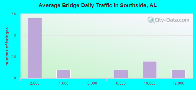
- 42,135Total average daily traffic
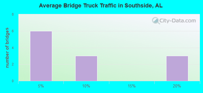
- 5,194Total average daily truck traffic
- 54,487Total future (year 2033) average daily traffic
- National Bridge Inventory (NBI) Registered Bridges for Southside
- No street view available for this location
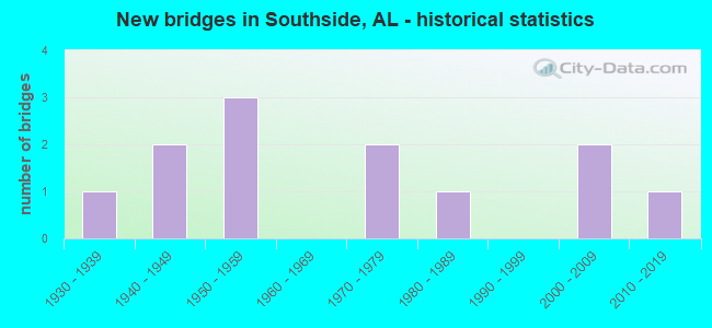
- New bridges - historical statistics
- 11930-1939
- 21940-1949
- 31950-1959
- 21970-1979
- 11980-1989
- 22000-2009
- 12010-2019
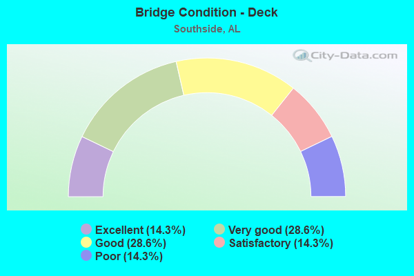
- Bridge Condition - Deck
- 14.3%Excellent
- 28.6%Very good
- 28.6%Good
- 14.3%Satisfactory
- 14.3%Poor
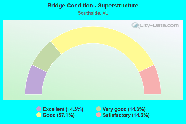
- Bridge Condition - Superstructure
- 14.3%Excellent
- 14.3%Very good
- 57.1%Good
- 14.3%Satisfactory
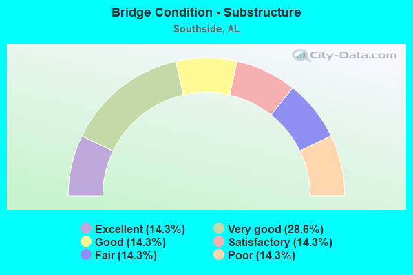
- Bridge Condition - Substructure
- 14.3%Excellent
- 28.6%Very good
- 14.3%Good
- 14.3%Satisfactory
- 14.3%Fair
- 14.3%Poor
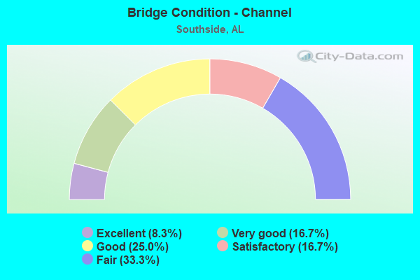
- Bridge Condition - Channel
- 8.3%Excellent
- 16.7%Very good
- 25.0%Good
- 16.7%Satisfactory
- 33.3%Fair
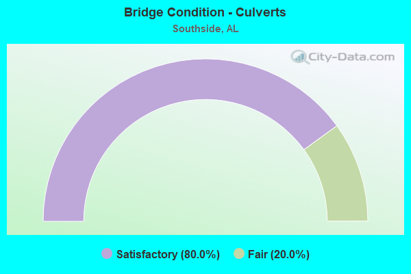
- Bridge Condition - Culverts
- 80.0%Satisfactory
- 20.0%Fair
Find on map >> Show street view
Structure Number: 1221, Location: JCT.AL#22*DALLASCO#81 (Lat: 32.468333, Lng: -87.006667), Route carried "on" structure: State highway 22, Year Built: 1935, Status: Open, Structure Length: 0.76m (2.49ft), Average Daily Traffic: 7,910 (year 2013), Truck Traffic: 4%, Average Future Daily Traffic: 9,595 (year 2033), Design Load: H 15, Features Intersected: FOURMILECREEK
Minimum Vertical Clearance: 30+ m (98+ ft), Kilometerpoint: 44.807, Lanes on structure: 2, Owner: State Highway Agency, Approaching Roadway Width: 11.0m (36.1ft), Skew: 3 degrees, Material/Design: Concrete continuous, Design/Construction: Culvert, Number Of Spans In Main Unit: 2, Length of Maximum Span: 3.0m (9.8ft)
Condition: Channel: Satisfactory, Culverts: Satisfactory, Operating Rating: 88.9 metric tons, Method Used To Determine Operating Rating: Load Factor (LF), Inventory Rating: 68.8 metric tons, Method Used To Determine Inventory Rating: Load Factor (LF), Structural Evaluation: Equal to present minimum criteria, Waterway Adequacy: Superior to present desirable criteria, Approach Roadway Alignment: Better than present minimum criteria, Length Of Structure Improvement: 1.41m (4.63ft), Designated Inspection Frequency: Every 24 months, Inspection Date: November 2020, Bridge Improvement Cost: $366,000, Roadway Improvement Cost: $37,000, Total Project Cost: $403,000 ( Estimate for 2022)
Find on map >> Show street view
Structure Number: 297, Location: GOLDEN VALLEY RD (Lat: 33.821867, Lng: -85.958708), Route carried "on" structure: County highway 163, Year Built: 1946, Year Reconstructed: 1994, Status: Open, Structure Length: 3.11m (10.20ft), Average Daily Traffic: 317 (year 1994), Truck Traffic: 9%, Average Future Daily Traffic: 250 (year 2041), Design Load: HS 20, Features Intersected: OHATCHEE CREEK, Facility Carried by Structure: 5 MI NE OHATCHEE
Minimum Vertical Clearance: 30+ m (98+ ft), Kilometerpoint: 0.010, Lanes on structure: 2, Owner: County Highway Agency, Approaching Roadway Width: 9.1m (29.9ft), Material/Design: Concrete, Design/Construction: Channel Beam, Number Of Spans In Main Unit: 2, Length of Maximum Span: 10.4m (34.1ft), Curb-To-Curb Width: 8.5m (27.9ft), Out-to-Out Width: 9.3m (30.5ft)
Condition: Deck: Good, Superstructure: Good, Substructure: Very good, Channel: Good, Operating Rating: 62.4 metric tons, Method Used To Determine Operating Rating: Load Factor (LF), Inventory Rating: 37.5 metric tons, Method Used To Determine Inventory Rating: Load Factor (LF), Structural Evaluation: Better than present minimum criteria, Deck Geometry: Equal to present minimum criteria, Waterway Adequacy: Equal to present minimum criteria, Approach Roadway Alignment: Equal to present minimum criteria, Length Of Structure Improvement: 3.96m (12.99ft), Designated Inspection Frequency: Every 24 months, Inspection Date: Febuary 2021, Bridge Improvement Cost: $815,000, Roadway Improvement Cost: $82,000, Total Project Cost: $897,000 ( Estimate for 2022), Deck Structure Type: Concrete Precast Panels
Find on map >> Show street view
Structure Number: 497, Location: ROCK SPRINGS RD. BIG (Lat: 33.833472, Lng: -85.959356), Route carried "on" structure: County highway 192, Year Built: 1954, Status: Closed, Structure Length: 2.13m (6.99ft), Average Daily Traffic: 145 (year 1993), Truck Traffic: 1%, Average Future Daily Traffic: 215 (year 2037), Features Intersected: TRIB. OHATCHEE CREEK, Facility Carried by Structure: 6 MI NE OHATCHEE
Minimum Vertical Clearance: 30+ m (98+ ft), Kilometerpoint: 0.010, Lanes on structure: 2, Owner: County Highway Agency, Approaching Roadway Width: 3.7m (12.1ft), Material/Design: Steel, Design/Construction: Stringer/Multi-beam, Number Of Spans In Main Unit: 2, Length of Maximum Span: 10.7m (35.1ft), Curb-To-Curb Width: 6.6m (21.7ft), Out-to-Out Width: 7.1m (23.3ft)
Condition: Deck: Poor, Superstructure: Satisfactory, Substructure: Poor, Channel: Fair, Deck Geometry: Meets minimum limits, Waterway Adequacy: Better than present minimum criteria, Approach Roadway Alignment: Equal to present minimum criteria, Bridge Posting: Required (Relationship of Operating Rating to Maximum Legal Load: > 39.9% below), Length Of Structure Improvement: 2.91m (9.55ft), Designated Inspection Frequency: Every 24 months, Other Special Inspection Frequency: Every 12 months, Inspection Date: March 2017, Other Special Inspection Date: March 2018, Bridge Improvement Cost: $460,000, Roadway Improvement Cost: $46,000, Total Project Cost: $506,000 ( Estimate for 2022), Deck Structure Type: Concrete Cast-file-Place, Wearing Surface/Protective System: Wearing Surface: Bituminous
Find on map >> Show street view
Structure Number: 6352, Location: AL 77 * GREEN CREEK (Lat: 33.854439, Lng: -86.045594), Route carried "on" structure: State highway 77, Year Built: 1958, Status: Open, Structure Length: 2.23m (7.32ft), Average Daily Traffic: 9,786 (year 2018), Truck Traffic: 16%, Average Future Daily Traffic: 13,700 (year 2038), Design Load: HS 20, Features Intersected: GREEN CREEK
Minimum Vertical Clearance: 7.56m (24.80ft), Kilometerpoint: 153.620, Lanes on structure: 2, Base Highway Network: Yes, Owner: State Highway Agency, Approaching Roadway Width: 7.3m (24.0ft), Skew: 4 degrees, Material/Design: Concrete, Design/Construction: Culvert, Number Of Spans In Main Unit: 4, Length of Maximum Span: 3.7m (12.1ft)
Condition: Channel: Very good, Culverts: Satisfactory, Operating Rating: 88.9 metric tons, Method Used To Determine Operating Rating: Load Factor (LF), Inventory Rating: 74.2 metric tons, Method Used To Determine Inventory Rating: Load Factor (LF), Structural Evaluation: Equal to present minimum criteria, Waterway Adequacy: Equal to present minimum criteria, Approach Roadway Alignment: Equal to present desirable criteria, Length Of Structure Improvement: 3.04m (9.97ft), Designated Inspection Frequency: Every 24 months, Underwater Inspection Frequency: Every 24 months, Inspection Date: May 2020, Underwater Inspection Date: May 2020, Bridge Improvement Cost: $1,282,000, Roadway Improvement Cost: $128,000, Total Project Cost: $1,410,000 ( Estimate for 2022), Wearing Surface/Protective System: Wearing Surface: Bituminous
Find on map >> Show street view
Structure Number: 6353, Location: AL 77 IN SOUTHSIDE (Lat: 33.885992, Lng: -86.030786), Route carried "on" structure: State highway 77, Year Built: 1958, Status: Open, Structure Length: 1.01m (3.31ft), Average Daily Traffic: 10,931 (year 2018), Truck Traffic: 15%, Average Future Daily Traffic: 15,303 (year 2038), Design Load: HS 20, Features Intersected: BRANCH
Minimum Vertical Clearance: 30+ m (98+ ft), Kilometerpoint: 157.490, Lanes on structure: 2, Base Highway Network: Yes, Owner: State Highway Agency, Approaching Roadway Width: 7.3m (24.0ft), Material/Design: Concrete, Design/Construction: Culvert, Number Of Spans In Main Unit: 3, Length of Maximum Span: 3.0m (9.8ft)
Condition: Channel: Fair, Culverts: Fair, Operating Rating: 67.4 metric tons, Method Used To Determine Operating Rating: Load Factor (LF), Inventory Rating: 40.5 metric tons, Method Used To Determine Inventory Rating: Load Factor (LF), Structural Evaluation: Somewhat better than minimum adequacy, Waterway Adequacy: Equal to present minimum criteria, Approach Roadway Alignment: Equal to present desirable criteria, Length Of Structure Improvement: 1.68m (5.51ft), Designated Inspection Frequency: Every 24 months, Inspection Date: April 2020, Bridge Improvement Cost: $582,000, Roadway Improvement Cost: $58,000, Total Project Cost: $640,000 ( Estimate for 2022), Wearing Surface/Protective System: Wearing Surface: Bituminous
Find on map >> Show street view
Structure Number: 10648, Location: 0.4 MI S. OF GRN VLY RD (Lat: 33.872342, Lng: -86.012892), Route carried "on" structure: County highway 161, Year Built: 1972, Status: Posted for load, Structure Length: 0.91m (2.99ft), Average Daily Traffic: 110 (year 2003), Truck Traffic: 8%, Average Future Daily Traffic: 150 (year 2034), Features Intersected: GREENS CREEK, Facility Carried by Structure: MOUNTAIN PASS RD.
Minimum Vertical Clearance: 7.56m (24.80ft), Kilometerpoint: 0.010, Lanes on structure: 1, Owner: County Highway Agency, Approaching Roadway Width: 6.4m (21.0ft), Material/Design: Wood or Timber, Design/Construction: Stringer/Multi-beam, Number Of Spans In Main Unit: 2, Length of Maximum Span: 4.6m (15.1ft), Curb-To-Curb Width: 7.5m (24.6ft), Out-to-Out Width: 7.5m (24.6ft)
Condition: Deck: Very good, Superstructure: Good, Substructure: Fair, Channel: Fair, Operating Rating: 14.2 metric tons, Method Used To Determine Operating Rating: Allowable Stress (AS), Inventory Rating: 10.4 metric tons, Method Used To Determine Inventory Rating: Allowable Stress (AS), Structural Evaluation: High priority of replacement, Deck Geometry: Somewhat better than minimum adequacy, Waterway Adequacy: Better than present minimum criteria, Approach Roadway Alignment: Somewhat better than minimum adequacy, Bridge Posting: Required (Relationship of Operating Rating to Maximum Legal Load: > 39.9% below), Length Of Structure Improvement: 1.58m (5.18ft), Designated Inspection Frequency: Every 24 months, Other Special Inspection Frequency: Every 12 months, Inspection Date: September 2021, Other Special Inspection Date: September 2021, Bridge Improvement Cost: $260,000, Roadway Improvement Cost: $26,000, Total Project Cost: $286,000 ( Estimate for 2022), Deck Structure Type: Wood or Timber, Wearing Surface/Protective System: Wearing Surface: Wood or Timber
Find on map >> Show street view
Structure Number: 1221, Location: AL 77 * COOSA RIVER (Lat: 33.940567, Lng: -86.025858), Route carried "on" structure: State highway 77, Year Built: 1979, Status: Open, Structure Length: 45.20m (148.29ft), Average Daily Traffic: 9,372 (year 2019), Truck Traffic: 16%, Average Future Daily Traffic: 13,121 (year 2039), Design Load: HS 20, Features Intersected: COOSA RIVER
Minimum Vertical Clearance: 30+ m (98+ ft), Kilometerpoint: 164.105, Lanes on structure: 2, Base Highway Network: Yes, Owner: State Highway Agency, Approaching Roadway Width: 12.2m (40.0ft), Material/Design: Steel continuous, Design/Construction: Girder and Floorbeam System, Number Of Spans In Main Unit: 3, Number Of Approach Spans: 8, Length of Maximum Span: 79.2m (259.8ft), Curb-To-Curb Width: 12.2m (40.0ft), Out-to-Out Width: 13.0m (42.7ft)
Condition: Deck: Satisfactory, Superstructure: Good, Substructure: Good, Channel: Satisfactory, Operating Rating: 45.9 metric tons, Method Used To Determine Operating Rating: Load Factor (LF), Inventory Rating: 27.5 metric tons, Method Used To Determine Inventory Rating: Load Factor (LF), Structural Evaluation: Equal to present minimum criteria, Deck Geometry: Better than present minimum criteria, Waterway Adequacy: Superior to present desirable criteria, Approach Roadway Alignment: Equal to present desirable criteria, Length Of Structure Improvement: 45.20m (148.29ft), Designated Inspection Frequency: Every 24 months, Critical Feature Inspection Frequency: Every 24 months, Underwater Inspection Frequency: Every 24 months, Inspection Date: July 2021, Critical Feature Inspection Date: July 2021, Underwater Inspection Date: June 2020, Bridge Improvement Cost: $13,017,000, Roadway Improvement Cost: $1,302,000, Total Project Cost: $14,319,000 ( Estimate for 2022), Deck Structure Type: Concrete Cast-file-Place
Find on map >> Show street view
Structure Number: 14697, Location: GREENSPORT RD (Lat: 33.865297, Lng: -85.975694), Route carried "on" structure: County highway 3, Year Built: 1940, Year Reconstructed: 1989, Status: Open, Structure Length: 0.85m (2.79ft), Average Daily Traffic: 210 (year 1993), Truck Traffic: 1%, Average Future Daily Traffic: 265 (year 2040), Features Intersected: CREEK, Facility Carried by Structure: GREENSPORT RD
Minimum Vertical Clearance: 30+ m (98+ ft), Kilometerpoint: 0.010, Lanes on structure: 1, Owner: County Highway Agency, Approaching Roadway Width: 6.1m (20.0ft), Material/Design: Steel, Design/Construction: Stringer/Multi-beam, Number Of Spans In Main Unit: 1, Length of Maximum Span: 8.5m (27.9ft), Curb-To-Curb Width: 6.9m (22.6ft), Out-to-Out Width: 7.3m (24.0ft)
Condition: Deck: Very good, Superstructure: Very good, Substructure: Very good, Channel: Good, Operating Rating: 53.5 metric tons, Method Used To Determine Operating Rating: Load Factor (LF), Inventory Rating: 31.8 metric tons, Method Used To Determine Inventory Rating: Load Factor (LF), Structural Evaluation: Better than present minimum criteria, Deck Geometry: Meets minimum limits, Waterway Adequacy: Better than present minimum criteria, Approach Roadway Alignment: Somewhat better than minimum adequacy, Length Of Structure Improvement: 1.51m (4.95ft), Designated Inspection Frequency: Every 24 months, Inspection Date: July 2020, Bridge Improvement Cost: $249,000, Roadway Improvement Cost: $25,000, Total Project Cost: $274,000 ( Estimate for 2022), Deck Structure Type: Concrete Cast-file-Place
Find on map >> Show street view
Structure Number: 14959, Location: ROCK SPRINGS RD. SMALL (Lat: 33.852953, Lng: -85.941719), Route carried "on" structure: County highway 192, Year Built: 1989, Status: Open, Structure Length: 1.22m (4.00ft), Average Daily Traffic: 171 (year 2007), Truck Traffic: 4%, Average Future Daily Traffic: 335 (year 2041), Design Load: HS 20, Features Intersected: TRIB. OHATCHEE CREEK, Facility Carried by Structure: 3 MI W US 431
Minimum Vertical Clearance: 30+ m (98+ ft), Kilometerpoint: 0.010, Lanes on structure: 2, Owner: County Highway Agency, Approaching Roadway Width: 6.1m (20.0ft), Material/Design: Steel, Design/Construction: Stringer/Multi-beam, Number Of Spans In Main Unit: 1, Length of Maximum Span: 12.2m (40.0ft), Curb-To-Curb Width: 6.8m (22.3ft), Out-to-Out Width: 7.3m (24.0ft)
Condition: Deck: Good, Superstructure: Good, Substructure: Satisfactory, Channel: Fair, Operating Rating: 43.5 metric tons, Method Used To Determine Operating Rating: Load Factor (LF), Inventory Rating: 26.3 metric tons, Method Used To Determine Inventory Rating: Load Factor (LF), Structural Evaluation: Equal to present minimum criteria, Deck Geometry: Meets minimum limits, Waterway Adequacy: Meets minimum limits, Approach Roadway Alignment: Somewhat better than minimum adequacy, Length Of Structure Improvement: 1.89m (6.20ft), Designated Inspection Frequency: Every 24 months, Inspection Date: March 2021, Bridge Improvement Cost: $311,000, Roadway Improvement Cost: $31,000, Total Project Cost: $342,000 ( Estimate for 2022), Deck Structure Type: Concrete Cast-file-Place
Find on map >> Show street view
Structure Number: 17798, Location: NUNNALLY LAKE ROAD (Lat: 33.853608, Lng: -85.976089), Route carried "on" structure: County highway , Year Built: 2002, Status: Open, Structure Length: 1.69m (5.54ft), Average Daily Traffic: 2,498 (year 2019), Truck Traffic: 5%, Average Future Daily Traffic: 391 (year 2042), Design Load: HS 20, Features Intersected: UNKNOWN CREEK, Facility Carried by Structure: NUNNALLY LAKE ROAD
Minimum Vertical Clearance: 30+ m (98+ ft), Kilometerpoint: 0.010, Lanes on structure: 2, Owner: County Highway Agency, Approaching Roadway Width: 8.5m (27.9ft), Skew: 3 degrees, Material/Design: Concrete, Design/Construction: Culvert, Number Of Spans In Main Unit: 4, Length of Maximum Span: 3.5m (11.5ft), Curb or Sidewalk Widths: Left: 0.3m (1.0ft), Right: 0.3m (1.0ft), Curb-To-Curb Width: 20.7m (67.9ft), Out-to-Out Width: 21.3m (69.9ft)
Condition: Channel: Good, Culverts: Satisfactory, Operating Rating: 88.9 metric tons, Method Used To Determine Operating Rating: Load Factor (LF), Inventory Rating: 72.0 metric tons, Method Used To Determine Inventory Rating: Load Factor (LF), Structural Evaluation: Equal to present minimum criteria, Deck Geometry: Superior to present desirable criteria, Waterway Adequacy: Equal to present desirable criteria, Approach Roadway Alignment: Equal to present desirable criteria, Length Of Structure Improvement: 2.38m (7.81ft), Designated Inspection Frequency: Every 24 months, Inspection Date: Febuary 2022, Bridge Improvement Cost: $961,000, Roadway Improvement Cost: $96,000, Total Project Cost: $1,057,000 ( Estimate for 2022)
Find on map >> Show street view
Structure Number: 20044, Location: PEEKS HILL RD. CULVERT (Lat: 33.859533, Lng: -85.977533), Route carried "on" structure: County highway , Year Built: 2009, Status: Open, Structure Length: 1.84m (6.04ft), Average Daily Traffic: 420 (year 2009), Truck Traffic: 1%, Average Future Daily Traffic: 792 (year 2039), Design Load: HS 20, Features Intersected: TALLASSEEHATCHEE CREEK, Facility Carried by Structure: 5 MI W US 431
Minimum Vertical Clearance: 30+ m (98+ ft), Kilometerpoint: 0.000, Lanes on structure: 2, Owner: County Highway Agency, Approaching Roadway Width: 5.5m (18.0ft), Skew: 5 degrees, Material/Design: Concrete, Design/Construction: Culvert, Number Of Spans In Main Unit: 4, Length of Maximum Span: 2.4m (7.9ft), Curb or Sidewalk Widths: Left: 0.2m (0.7ft), Right: 0.2m (0.7ft), Curb-To-Curb Width: 9.4m (30.8ft), Out-to-Out Width: 9.4m (30.8ft)
Condition: Channel: Very good, Culverts: Satisfactory, Operating Rating: 39.8 metric tons, Method Used To Determine Operating Rating: Load Factor (LF), Inventory Rating: 23.9 metric tons, Method Used To Determine Inventory Rating: Load Factor (LF), Structural Evaluation: Equal to present minimum criteria, Deck Geometry: Equal to present minimum criteria, Waterway Adequacy: Equal to present desirable criteria, Approach Roadway Alignment: Equal to present desirable criteria, Length Of Structure Improvement: 2.56m (8.40ft), Designated Inspection Frequency: Every 24 months, Inspection Date: July 2021, Bridge Improvement Cost: $888,000, Roadway Improvement Cost: $89,000, Total Project Cost: $977,000 ( Estimate for 2022)
Find on map >> Show street view
Structure Number: 20881, Location: GILBERTS FERRY RD. (Lat: 33.877158, Lng: -85.945456), Route carried "on" structure: County highway 162, Year Built: 2018, Status: Open, Structure Length: 6.10m (20.01ft), Average Daily Traffic: 265 (year 1993), Truck Traffic: 1%, Average Future Daily Traffic: 370 (year 2039), Design Load: HS 20, Features Intersected: CREEK, Facility Carried by Structure: GILBERTS FERRY RD.
Minimum Vertical Clearance: 30+ m (98+ ft), Kilometerpoint: 0.010, Lanes on structure: 2, Owner: County Highway Agency, Approaching Roadway Width: 8.5m (27.9ft), Material/Design: Prestressed concrete, Design/Construction: Stringer/Multi-beam, Number Of Spans In Main Unit: 2, Length of Maximum Span: 30.5m (100.1ft), Curb-To-Curb Width: 6.1m (20.0ft), Out-to-Out Width: 9.4m (30.8ft)
Condition: Deck: Excellent, Superstructure: Excellent, Substructure: Excellent, Channel: Excellent, Operating Rating: 76.1 metric tons, Method Used To Determine Operating Rating: Load Factor (LF), Inventory Rating: 45.6 metric tons, Method Used To Determine Inventory Rating: Load Factor (LF), Structural Evaluation: Superior to present desirable criteria, Deck Geometry: High priority of corrective action, Waterway Adequacy: Equal to present desirable criteria, Approach Roadway Alignment: Somewhat better than minimum adequacy, Length Of Structure Improvement: 7.14m (23.43ft), Designated Inspection Frequency: Every 24 months, Inspection Date: September 2021, Bridge Improvement Cost: $1,468,000, Roadway Improvement Cost: $147,000, Total Project Cost: $1,615,000 ( Estimate for 2022), Deck Structure Type: Concrete Cast-file-Place