Bridge Statistics for South St. Paul, Minnesota (MN)
Condition, Traffic, Stress, Structural Evaluation, Project Costs
- National Bridge Inventory (NBI) Statistics
- 16Number of bridges
- 151ft / 46.0mTotal length
- $1,000Total costs
- 697,138Total average daily traffic
- 37,313Total average daily truck traffic
- National Bridge Inventory (NBI) Registered Bridges for South St. Paul
- No street view available for this location

- New bridges - historical statistics
- 71970-1979
- 71980-1989
- 22000-2009
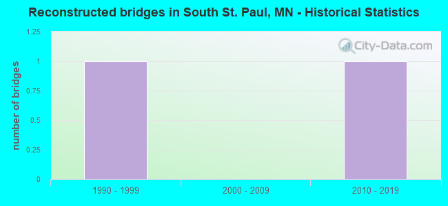
- Reconstructed bridges - Historical Statistics
- 11990-1999
- 02000-2009
- 12010-2019

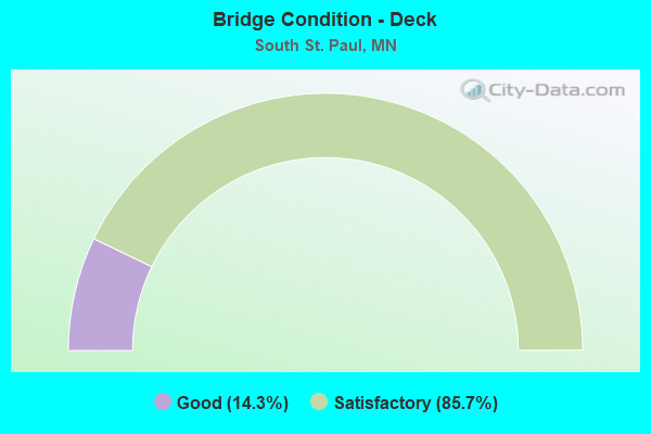
- Bridge Condition - Deck
- 14.3%Good
- 85.7%Satisfactory
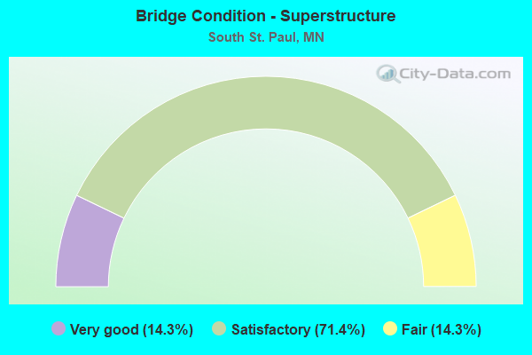
- Bridge Condition - Superstructure
- 14.3%Very good
- 71.4%Satisfactory
- 14.3%Fair
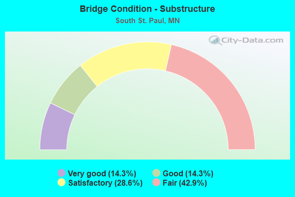
- Bridge Condition - Substructure
- 14.3%Very good
- 14.3%Good
- 28.6%Satisfactory
- 42.9%Fair
Find on map >> Show street view
Structure Number: 19016, Location: 0.7 MI N OF JCT TH 494 (Lat: 44.885083, Lng: -93.063392), Route carried "on" structure: US 52, Year Built: 1973, Status: Open, Structure Length: 4.98m (16.34ft), Average Daily Traffic: 31,500 (year 2019), Truck Traffic: 7%, Average Future Daily Traffic: 32,000 (year 2039), Design Load: HS 20, Features Intersected: SOUTH VIEW BLVD
Minimum Vertical Clearance: 30+ m (98+ ft), Kilometerpoint: 0.000, Lanes on structure: 2, Lanes under structure: 4, Base Highway Network: Yes, Owner: State Highway Agency, Approaching Roadway Width: 11.6m (38.1ft), Skew: 2 degrees, Material/Design: Prestressed concrete, Design/Construction: Stringer/Multi-beam, Number Of Spans In Main Unit: 3, Length of Maximum Span: 23.3m (76.4ft), Curb-To-Curb Width: 12.3m (40.4ft), Out-to-Out Width: 13.5m (44.3ft)
Condition: Deck: Satisfactory, Superstructure: Satisfactory, Substructure: Satisfactory, Operating Rating: 62.0 metric tons, Method Used To Determine Operating Rating: Load Factor (LF), Inventory Rating: 24.9 metric tons, Method Used To Determine Inventory Rating: Load Factor (LF), Structural Evaluation: Equal to present minimum criteria, Deck Geometry: Better than present minimum criteria, Underclear: Somewhat better than minimum adequacy, Approach Roadway Alignment: Equal to present desirable criteria, Designated Inspection Frequency: Every 24 months, Inspection Date: September 2021, Deck Structure Type: Concrete Cast-file-Place, Wearing Surface/Protective System: Wearing Surface: Low Slump Concrete
Find on map >> Show street view
Structure Number: 19021, Location: 2.7 MI N OF JCT TH 494 (Lat: 44.912358, Lng: -93.064256), Route carried "on" structure: County highway 4, Year Built: 1972, Status: Open, Structure Length: 5.06m (16.60ft), Average Daily Traffic: 11,200 (year 2017), Average Future Daily Traffic: 11,200 (year 2039), Design Load: HS 20, Features Intersected: US 52
Minimum Vertical Clearance: 30+ m (98+ ft), Kilometerpoint: 0.000, Lanes on structure: 4, Lanes under structure: 5, Owner: State Highway Agency, Approaching Roadway Width: 12.2m (40.0ft), Skew: 1 degrees, Material/Design: Prestressed concrete, Design/Construction: Stringer/Multi-beam, Number Of Spans In Main Unit: 2, Length of Maximum Span: 24.5m (80.4ft), Curb or Sidewalk Widths: Left: 0.0m, Right: 1.8m (5.9ft), Curb-To-Curb Width: 16.2m (53.1ft), Out-to-Out Width: 18.8m (61.7ft)
Condition: Deck: Good, Superstructure: Satisfactory, Substructure: Fair, Operating Rating: 54.2 metric tons, Method Used To Determine Operating Rating: Load Factor (LF), Inventory Rating: 33.0 metric tons, Method Used To Determine Inventory Rating: Load Factor (LF), Structural Evaluation: Somewhat better than minimum adequacy, Deck Geometry: Meets minimum limits, Underclear: Somewhat better than minimum adequacy, Approach Roadway Alignment: Equal to present desirable criteria, Designated Inspection Frequency: Every 24 months, Inspection Date: September 2021, Deck Structure Type: Concrete Cast-file-Place, Wearing Surface/Protective System: Wearing Surface: Low Slump Concrete, Deck Protection: Epoxy Coated Reinforcing
Find on map >> Show street view
Structure Number: 19025, Location: 3.0 MI N OF JCT TH 494 (Lat: 44.917553, Lng: -93.063819), Route carried "on" structure: , Year Built: 1973, Status: Open, Structure Length: 6.29m (20.64ft), Features Intersected: US 52, Facility Carried by Structure: PEDESTRIAN
Lanes under structure: 5, Owner: State Highway Agency, Material/Design: Steel continuous, Design/Construction: Stringer/Multi-beam, Number Of Spans In Main Unit: 2, Length of Maximum Span: 31.5m (103.3ft), Out-to-Out Width: 2.9m (9.5ft)
Condition: Deck: Satisfactory, Superstructure: Satisfactory, Substructure: Fair, Underclear: Equal to present minimum criteria, Bridge Posting: Required (Relationship of Operating Rating to Maximum Legal Load: > 39.9% below), Designated Inspection Frequency: Every 24 months, Inspection Date: September 2021, Deck Structure Type: Concrete Cast-file-Place
Find on map >> Show street view
Structure Number: 19544, Location: 0.1 MI E JCT OF CONCORD S (Lat: 44.906311, Lng: -93.045753), Route carried "on" structure: City street 340, Year Built: 2003, Status: Open, Structure Length: 9.68m (31.76ft), Average Daily Traffic: 300 (year 2003), Average Future Daily Traffic: 300 (year 2029), Design Load: HS 25 or greater, Features Intersected: UNION PACIFIC RR YARD
Minimum Vertical Clearance: 30+ m (98+ ft), Kilometerpoint: 0.000, Lanes on structure: 2, Owner: City or Municipal Highway Agency, Approaching Roadway Width: 7.9m (25.9ft), Material/Design: Prestressed concrete, Design/Construction: Stringer/Multi-beam, Number Of Spans In Main Unit: 3, Length of Maximum Span: 47.3m (155.2ft), Curb-To-Curb Width: 7.9m (25.9ft), Out-to-Out Width: 8.9m (29.2ft)
Condition: Deck: Satisfactory, Superstructure: Very good, Substructure: Very good, Operating Rating: 73.5 metric tons, Method Used To Determine Operating Rating: Load Factor (LF), Inventory Rating: 41.3 metric tons, Method Used To Determine Inventory Rating: Load Factor (LF), Structural Evaluation: Equal to present desirable criteria, Deck Geometry: Somewhat better than minimum adequacy, Underclear: Somewhat better than minimum adequacy, Approach Roadway Alignment: Meets minimum limits, Length Of Structure Improvement: 3.23m (10.60ft), Designated Inspection Frequency: Every 24 months, Inspection Date: October 2020, Bridge Improvement Cost: $999,999,000, Roadway Improvement Cost: $1,000, Total Project Cost: $1,000, Deck Structure Type: Concrete Cast-file-Place, Wearing Surface/Protective System: Wearing Surface: Monolithic Concrete, Deck Protection: Epoxy Coated Reinforcing
Find on map >> Show street view
Structure Number: 19865, Location: AT THE JCT TH 156; 494 (Lat: 44.876133, Lng: -93.030731), Route carried "on" structure: Interstate 494, Year Built: 1980, Year Reconstructed: 2019, Status: Open, Structure Length: 5.19m (17.03ft), Average Daily Traffic: 98,000 (year 2019), Truck Traffic: 6%, Average Future Daily Traffic: 117,000 (year 2039), Design Load: HS 20, Features Intersected: CSAH 56 (CONCORD STREET)
Minimum Vertical Clearance: 30+ m (98+ ft), Kilometerpoint: 0.000, Lanes on structure: 8, Lanes under structure: 4, Base Highway Network: Yes, Owner: State Highway Agency, Approaching Roadway Width: 36.6m (120.1ft), Skew: 32 degrees, Material/Design: Steel continuous, Design/Construction: Stringer/Multi-beam, Number Of Spans In Main Unit: 2, Length of Maximum Span: 27.6m (90.6ft), Curb-To-Curb Width: 43.4m (142.4ft), Out-to-Out Width: 45.1m (148.0ft)
Condition: Deck: Satisfactory, Superstructure: Satisfactory, Substructure: Good, Operating Rating: 37.3 metric tons, Method Used To Determine Operating Rating: Load and Resistance Factor Rating (LRFR) rating reported by rating factor(RF) method using HL-93 loadings, Inventory Rating: 28.8 metric tons, Method Used To Determine Inventory Rating: Load and Resistance Factor Rating (LRFR) rating reported by rating factor(RF) method using HL-93 loadings, Structural Evaluation: Equal to present minimum criteria, Deck Geometry: Superior to present desirable criteria, Underclear: Somewhat better than minimum adequacy, Approach Roadway Alignment: Equal to present desirable criteria, Designated Inspection Frequency: Every 24 months, Inspection Date: June 2021, Deck Structure Type: Concrete Cast-file-Place, Wearing Surface/Protective System: Wearing Surface: Low Slump Concrete, Deck Protection: Other
Find on map >> Show street view
Structure Number: 19895, Location: 1.0 MI E OF JCT TH 52 (Lat: 44.874447, Lng: -93.039925), Route carried "on" structure: City street 109, Year Built: 1983, Status: Open, Structure Length: 5.77m (18.93ft), Average Daily Traffic: 9,600 (year 2016), Average Future Daily Traffic: 9,600 (year 2039), Design Load: HS 20, Features Intersected: I 494
Minimum Vertical Clearance: 30+ m (98+ ft), Kilometerpoint: 0.000, Lanes on structure: 2, Lanes under structure: 6, Owner: State Highway Agency, Approaching Roadway Width: 13.4m (44.0ft), Material/Design: Steel continuous, Design/Construction: Stringer/Multi-beam, Number Of Spans In Main Unit: 2, Length of Maximum Span: 28.1m (92.2ft), Curb or Sidewalk Widths: Left: 1.8m (5.9ft), Right: 1.8m (5.9ft), Curb-To-Curb Width: 15.9m (52.2ft), Out-to-Out Width: 20.2m (66.3ft)
Condition: Deck: Satisfactory, Superstructure: Fair, Substructure: Fair, Operating Rating: 68.2 metric tons, Method Used To Determine Operating Rating: Load Factor (LF), Inventory Rating: 40.8 metric tons, Method Used To Determine Inventory Rating: Load Factor (LF), Structural Evaluation: Somewhat better than minimum adequacy, Deck Geometry: Superior to present desirable criteria, Underclear: Somewhat better than minimum adequacy, Approach Roadway Alignment: Equal to present desirable criteria, Designated Inspection Frequency: Every 24 months, Inspection Date: September 2021, Deck Structure Type: Concrete Cast-file-Place, Wearing Surface/Protective System: Wearing Surface: Low Slump Concrete, Deck Protection: Epoxy Coated Reinforcing
Find on map >> Show street view
Structure Number: 19896, Location: 0.4 MI E OF JCT TH 156 (Lat: 44.880481, Lng: -93.024475), Route carried "on" structure: Interstate 494, Year Built: 1988, Year Reconstructed: 2002, Status: Open, Structure Length: 7.94m (26.05ft), Average Daily Traffic: 98,000 (year 2019), Truck Traffic: 6%, Average Future Daily Traffic: 122,000 (year 2039), Design Load: HS 20, Features Intersected: UP Railroad Hardman Ave
Minimum Vertical Clearance: 30+ m (98+ ft), Kilometerpoint: 0.000, Lanes on structure: 7, Lanes under structure: 2, Base Highway Network: Yes, Owner: State Highway Agency, Approaching Roadway Width: 36.6m (120.1ft), Skew: 34 degrees, Material/Design: Prestressed concrete, Design/Construction: Stringer/Multi-beam, Number Of Spans In Main Unit: 2, Length of Maximum Span: 42.8m (140.4ft), Curb-To-Curb Width: 49.3m (161.7ft), Out-to-Out Width: 50.0m (164.0ft)
Condition: Deck: Satisfactory, Superstructure: Satisfactory, Substructure: Satisfactory, Operating Rating: 72.2 metric tons, Method Used To Determine Operating Rating: Load Factor (LF), Inventory Rating: 23.3 metric tons, Method Used To Determine Inventory Rating: Load Factor (LF), Structural Evaluation: Somewhat better than minimum adequacy, Deck Geometry: Superior to present desirable criteria, Underclear: Better than present minimum criteria, Approach Roadway Alignment: Equal to present desirable criteria, Designated Inspection Frequency: Every 24 months, Inspection Date: September 2021, Deck Structure Type: Concrete Cast-file-Place, Wearing Surface/Protective System: Wearing Surface: Low Slump Concrete, Deck Protection: Epoxy Coated Reinforcing
Find on map >> Show street view
Structure Number: 19J54, Location: 0.1 MI S OF JCT CR 4 (Lat: 44.910500, Lng: -93.058044), Route carried "on" structure: City street 101, Year Built: 2008, Status: Open, Structure Length: 1.14m (3.74ft), Average Daily Traffic: 1,700 (year 2016), Average Future Daily Traffic: 1,700 (year 2039), Design Load: HS 25 or greater, Features Intersected: PED UNDERPASS
Minimum Vertical Clearance: 30+ m (98+ ft), Kilometerpoint: 0.000, Lanes on structure: 2, Owner: County Highway Agency, Approaching Roadway Width: 10.5m (34.4ft), Skew: 6 degrees, Material/Design: Concrete, Design/Construction: Culvert, Number Of Spans In Main Unit: 1, Length of Maximum Span: 11.4m (37.4ft)
Condition: Channel: Very good, Culverts: Very good, Operating Rating: 58.8 metric tons, Method Used To Determine Operating Rating: Assigned rating based on Load Factor Design (LFD) reported in metric tons, Inventory Rating: 39.2 metric tons, Method Used To Determine Inventory Rating: Assigned rating based on Load Factor Design (LFD) reported in metric tons, Structural Evaluation: Equal to present desirable criteria, Approach Roadway Alignment: Equal to present desirable criteria, Designated Inspection Frequency: Every 24 months, Inspection Date: December 2021
Find on map >> Show street view
Structure Number: 19015, Location: 0.7 MI N OF JCT TH 494 (Lat: 44.884961, Lng: -93.063650), Route carried "under" structure: County highway 14, Year Built: 1973, Structure Length: 0. m, Average Daily Traffic: 14,300 (year 2005), Features Intersected: SOUTH VIEW BLVD, Facility Carried by Structure: US 52
Minimum Vertical Clearance: 5.00m (16.40ft), Kilometerpoint: 0.000, Lanes on structure: 2, Lanes under structure: 4, Material/Design: Prestressed concrete, Design/Construction: Stringer/Multi-beam, Length of Maximum Span: 23.3m (76.4ft)
Find on map >> Show street view
Structure Number: 19016, Location: 0.7 MI N OF JCT TH 494 (Lat: 44.885083, Lng: -93.063392), Route carried "under" structure: County highway 14, Year Built: 1973, Structure Length: 0. m, Average Daily Traffic: 14,300 (year 2005), Features Intersected: SOUTH VIEW BLVD, Facility Carried by Structure: US 52
Minimum Vertical Clearance: 5.97m (19.59ft), Kilometerpoint: 0.000, Lanes on structure: 2, Lanes under structure: 4, Material/Design: Prestressed concrete, Design/Construction: Stringer/Multi-beam, Length of Maximum Span: 23.3m (76.4ft)
Find on map >> Show street view
Structure Number: 19021, Location: 2.7 MI N OF JCT TH 494 (Lat: 44.912358, Lng: -93.064256), Route carried "under" structure: US 52, Year Built: 1972, Structure Length: 0. m, Average Daily Traffic: 66,000 (year 2019), Truck Traffic: 7%, Features Intersected: US 52, Facility Carried by Structure: CR 4
Minimum Vertical Clearance: 6.07m (19.91ft), Kilometerpoint: 0.000, Lanes on structure: 4, Lanes under structure: 5, Material/Design: Prestressed concrete, Design/Construction: Stringer/Multi-beam, Length of Maximum Span: 24.5m (80.4ft)
Find on map >> Show street view
Structure Number: 19025, Location: 3.0 MI N OF JCT TH 494 (Lat: 44.917553, Lng: -93.063819), Route carried "under" structure: US 52, Year Built: 1973, Structure Length: 0. m, Average Daily Traffic: 67,000 (year 2019), Truck Traffic: 7%, Features Intersected: US 52, Facility Carried by Structure: PEDESTRIAN
Minimum Vertical Clearance: 5.82m (19.09ft), Kilometerpoint: 0.000, Lanes on structure: 5, Lanes under structure: 5, Material/Design: Steel continuous, Design/Construction: Stringer/Multi-beam, Length of Maximum Span: 31.5m (103.3ft)
Find on map >> Show street view
Structure Number: 19865, Location: AT THE JCT TH 156; 494 (Lat: 44.876133, Lng: -93.030731), Route carried "under" structure: County highway 56, Year Built: 1980, Structure Length: 0. m, Average Daily Traffic: 10,362 (year 2019), Truck Traffic: 5%, Features Intersected: CSAH 56 (CONCORD STREET), Facility Carried by Structure: I 494
Minimum Vertical Clearance: 4.97m (16.31ft), Kilometerpoint: 0.000, Lanes on structure: 6, Lanes under structure: 4, Material/Design: Steel continuous, Design/Construction: Stringer/Multi-beam, Length of Maximum Span: 27.6m (90.6ft)
Find on map >> Show street view
Structure Number: 19894, Location: 0.8 MI E OF JCT TH 52 (Lat: 44.874533, Lng: -93.042458), Route carried "under" structure: Interstate 494, Year Built: 1983, Structure Length: 0. m, Average Daily Traffic: 135,203 (year 2019), Truck Traffic: 5%, Features Intersected: I 494, Facility Carried by Structure: MSAS 108
Minimum Vertical Clearance: 4.97m (16.31ft), Kilometerpoint: 0.000, Lanes on structure: 2, Lanes under structure: 6, Material/Design: Steel continuous, Design/Construction: Stringer/Multi-beam, Length of Maximum Span: 28.2m (92.5ft)
Find on map >> Show street view
Structure Number: 19895, Location: 1.0 MI E OF JCT TH 52 (Lat: 44.874447, Lng: -93.039925), Route carried "under" structure: Interstate 494, Year Built: 1983, Structure Length: 0. m, Average Daily Traffic: 135,203 (year 2019), Truck Traffic: 5%, Features Intersected: I 494, Facility Carried by Structure: MSAS 109
Minimum Vertical Clearance: 5.33m (17.49ft), Kilometerpoint: 0.000, Lanes on structure: 2, Lanes under structure: 6, Material/Design: Steel continuous, Design/Construction: Stringer/Multi-beam, Length of Maximum Span: 28.1m (92.2ft)
Find on map >> Show street view
Structure Number: 19896, Location: 0.4 MI E OF JCT TH 156 (Lat: 44.880481, Lng: -93.024475), Route carried "under" structure: City street 152, Year Built: 1988, Structure Length: 0. m, Average Daily Traffic: 4,470 (year 1972), Features Intersected: UP Railroad Hardman Ave, Facility Carried by Structure: I 494
Minimum Vertical Clearance: 6.77m (22.21ft), Kilometerpoint: 0.000, Lanes on structure: 7, Lanes under structure: 2, Material/Design: Prestressed concrete, Design/Construction: Stringer/Multi-beam, Length of Maximum Span: 42.8m (140.4ft)