Bridge Statistics for South Lyon, Michigan (MI)
Condition, Traffic, Stress, Structural Evaluation, Project Costs
- National Bridge Inventory (NBI) Statistics
- 15Number of bridges
- 66ft / 20.2mTotal length
- 149,655Total average daily traffic
- 8,527Total average daily truck traffic
- National Bridge Inventory (NBI) Registered Bridges for South Lyon
- No street view available for this location
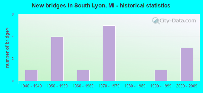
- New bridges - historical statistics
- 11940-1949
- 41950-1959
- 11960-1969
- 51970-1979
- 11990-1999
- 32000-2009


- Bridge Condition - Deck
- 33.3%Very good
- 50.0%Good
- 16.7%Fair

- Bridge Condition - Superstructure
- 16.7%Very good
- 66.7%Good
- 16.7%Satisfactory

- Bridge Condition - Substructure
- 16.7%Very good
- 66.7%Good
- 16.7%Satisfactory

- Bridge Condition - Channel
- 37.5%Good
- 12.5%Satisfactory
- 25.0%Fair
- 25.0%Poor

- Bridge Condition - Culverts
- 25.0%Satisfactory
- 25.0%Serious
- 50.0%Critical
Find on map >> Show street view
Structure Number: 577, Location: 3.4 MI E OF US-23 (Lat: 42.521481, Lng: -83.689097), Route carried "on" structure: County highway 4793, Year Built: 2008, Status: Open, Structure Length: 7.92m (25.98ft), Average Daily Traffic: 2,500 (year 1988), Truck Traffic: 15%, Average Future Daily Traffic: 25,300 (year 2028), Design Load: Greater than HL93, Features Intersected: I-96, Facility Carried by Structure: KENSINGTON RD
Minimum Vertical Clearance: 30.48m (100.00ft), Kilometerpoint: 2.816, Lanes on structure: 4, Lanes under structure: 8, Owner: State Highway Agency, Approaching Roadway Width: 18.9m (62.0ft), Skew: 2 degrees, Material/Design: Steel continuous, Design/Construction: Stringer/Multi-beam, Number Of Spans In Main Unit: 2, Length of Maximum Span: 39.1m (128.3ft), Curb-To-Curb Width: 20.7m (67.9ft), Out-to-Out Width: 26.2m (86.0ft)
Condition: Deck: Good, Superstructure: Satisfactory, Substructure: Satisfactory, Operating Rating: 75.0 metric tons, Method Used To Determine Operating Rating: Load Factor (LF), Inventory Rating: 45.0 metric tons, Method Used To Determine Inventory Rating: Load Factor (LF), Structural Evaluation: Equal to present minimum criteria, Deck Geometry: Superior to present desirable criteria, Underclear: High priority of corrective action, Approach Roadway Alignment: Equal to present desirable criteria, Designated Inspection Frequency: Every 24 months, Inspection Date: July 2021, Deck Structure Type: Concrete Cast-file-Place, Wearing Surface/Protective System: Wearing Surface: Monolithic Concrete, Deck Protection: Epoxy Coated Reinforcing
Find on map >> Show street view
Structure Number: 5809, Location: SEC 26 GREEN OAK TWP (Lat: 42.452942, Lng: -83.696022), Route carried "on" structure: County highway 4793, Year Built: 1995, Status: Open, Structure Length: 1.82m (5.97ft), Average Daily Traffic: 6,178 (year 2020), Average Future Daily Traffic: 7,414 (year 2040), Design Load: HS 20, Features Intersected: WALKER DRAIN, Facility Carried by Structure: RUSHTON ROAD
Minimum Vertical Clearance: 30.48m (100.00ft), Kilometerpoint: 2.536, Lanes on structure: 2, Owner: County Highway Agency, Approaching Roadway Width: 7.9m (25.9ft), Material/Design: Prestressed concrete, Design/Construction: Box Beam or Girders - Multiple, Number Of Spans In Main Unit: 1, Length of Maximum Span: 17.0m (55.8ft), Curb-To-Curb Width: 12.5m (41.0ft), Out-to-Out Width: 13.3m (43.6ft)
Condition: Deck: Very good, Superstructure: Good, Substructure: Very good, Channel: Good, Operating Rating: 86.5 metric tons, Method Used To Determine Operating Rating: Load Factor (LF) rating reported by rating factor (RF) method using MS18 loading, Inventory Rating: 51.8 metric tons, Method Used To Determine Inventory Rating: Load Factor (LF) rating reported by rating factor (RF) method using MS18 loading, Structural Evaluation: Better than present minimum criteria, Deck Geometry: Somewhat better than minimum adequacy, Waterway Adequacy: Superior to present desirable criteria, Approach Roadway Alignment: Equal to present desirable criteria, Designated Inspection Frequency: Every 24 months, Inspection Date: July 2021, Deck Structure Type: Concrete Cast-file-Place, Wearing Surface/Protective System: Wearing Surface: Monolithic Concrete, Deck Protection: Epoxy Coated Reinforcing
Find on map >> Show street view
Structure Number: 5844, Location: SEC 14 GREEN OAK TWP (Lat: 42.481961, Lng: -83.697769), Route carried "on" structure: County highway 4793, Year Built: 1958, Status: Open, Structure Length: 0.91m (2.99ft), Average Daily Traffic: 3,900 (year 2019), Average Future Daily Traffic: 4,680 (year 2039), Design Load: HS 20+Mod, Features Intersected: DAVIS CREEK, Facility Carried by Structure: RUSHTON ROAD
Minimum Vertical Clearance: 30.48m (100.00ft), Kilometerpoint: 5.794, Lanes on structure: 2, Owner: County Highway Agency, Approaching Roadway Width: 8.5m (27.9ft), Skew: 3 degrees, Material/Design: Concrete, Design/Construction: Slab, Number Of Spans In Main Unit: 1, Length of Maximum Span: 8.8m (28.9ft), Curb-To-Curb Width: 9.1m (29.9ft), Out-to-Out Width: 10.7m (35.1ft)
Condition: Deck: Very good, Superstructure: Good, Substructure: Good, Channel: Satisfactory, Operating Rating: 42.8 metric tons, Method Used To Determine Operating Rating: Load Factor (LF) rating reported by rating factor (RF) method using MS18 loading, Inventory Rating: 25.6 metric tons, Method Used To Determine Inventory Rating: Load Factor (LF) rating reported by rating factor (RF) method using MS18 loading, Structural Evaluation: Equal to present minimum criteria, Deck Geometry: Meets minimum limits, Waterway Adequacy: Equal to present desirable criteria, Approach Roadway Alignment: Equal to present desirable criteria, Designated Inspection Frequency: Every 24 months, Inspection Date: August 2021, Deck Structure Type: Concrete Cast-file-Place, Wearing Surface/Protective System: Wearing Surface: Monolithic Concrete
Find on map >> Show street view
Structure Number: 5845, Location: SEC 1-2 GREEN OAK TWP (Lat: 42.513700, Lng: -83.689750), Route carried "on" structure: County highway 4793, Year Built: 1978, Status: Open, Structure Length: 0.91m (2.99ft), Average Daily Traffic: 13,390 (year 2019), Average Future Daily Traffic: 16,068 (year 2039), Design Load: HS 20+Mod, Features Intersected: ISLAND PARK SERVICE DR, Facility Carried by Structure: KENSINGTON ROAD
Minimum Vertical Clearance: 30.48m (100.00ft), Kilometerpoint: 1.476, Lanes on structure: 2, Lanes under structure: 1, Owner: County Highway Agency, Approaching Roadway Width: 11.0m (36.1ft), Material/Design: Steel, Design/Construction: Stringer/Multi-beam, Number Of Spans In Main Unit: 1, Length of Maximum Span: 8.5m (27.9ft), Curb-To-Curb Width: 11.0m (36.1ft), Out-to-Out Width: 15.4m (50.5ft)
Condition: Deck: Good, Superstructure: Good, Substructure: Good, Operating Rating: 91.0 metric tons, Method Used To Determine Operating Rating: Load Factor (LF) rating reported by rating factor (RF) method using MS18 loading, Inventory Rating: 54.4 metric tons, Method Used To Determine Inventory Rating: Load Factor (LF) rating reported by rating factor (RF) method using MS18 loading, Structural Evaluation: Better than present minimum criteria, Deck Geometry: Meets minimum limits, Underclear: High priority of corrective action, Approach Roadway Alignment: Equal to present desirable criteria, Designated Inspection Frequency: Every 24 months, Inspection Date: August 2021, Deck Structure Type: Concrete Cast-file-Place, Wearing Surface/Protective System: Wearing Surface: Bituminous
Find on map >> Show street view
Structure Number: 5865, Location: SEC 13 GREEN OAK TWP (Lat: 42.488508, Lng: -83.668572), Route carried "on" structure: County highway , Year Built: 1979, Status: Open, Structure Length: 0.76m (2.49ft), Average Daily Traffic: 470 (year 2012), Average Future Daily Traffic: 1,100 (year 2042), Design Load: H 20, Features Intersected: DAVIS CREEK, Facility Carried by Structure: DIXBORO ROAD
Minimum Vertical Clearance: 30.48m (100.00ft), Kilometerpoint: 1.497, Lanes on structure: 2, Owner: County Highway Agency, Approaching Roadway Width: 6.7m (22.0ft), Material/Design: Steel, Design/Construction: Culvert, Number Of Spans In Main Unit: 2, Length of Maximum Span: 3.3m (10.8ft), Curb-To-Curb Width: 9.1m (29.9ft), Out-to-Out Width: 9.1m (29.9ft)
Condition: Channel: Poor, Culverts: Satisfactory, Operating Rating: 97.2 metric tons, Method Used To Determine Operating Rating: Load Factor (LF) rating reported by rating factor (RF) method using MS18 loading, Inventory Rating: 59.0 metric tons, Method Used To Determine Inventory Rating: Load Factor (LF) rating reported by rating factor (RF) method using MS18 loading, Structural Evaluation: Equal to present minimum criteria, Deck Geometry: Equal to present minimum criteria, Waterway Adequacy: Equal to present minimum criteria, Approach Roadway Alignment: Equal to present desirable criteria, Designated Inspection Frequency: Every 24 months, Inspection Date: October 2021
Find on map >> Show street view
Structure Number: 8171, Location: BET DIXBORO AND KENT LK R (Lat: 42.516350, Lng: -83.661464), Route carried "on" structure: County highway 6318, Year Built: 2009, Status: Open, Structure Length: 4.01m (13.16ft), Average Daily Traffic: 4,517 (year 2007), Truck Traffic: 5%, Average Future Daily Traffic: 6,700 (year 2027), Design Load: HS 20+Mod, Features Intersected: KENT LAKE, Facility Carried by Structure: GRAND RIVER AVE
Minimum Vertical Clearance: 30.48m (100.00ft), Kilometerpoint: 2.327, Lanes on structure: 2, Base Highway Network: Yes (Inventory Route: 410, Subroute: 42), Owner: County Highway Agency, Approaching Roadway Width: 12.2m (40.0ft), Skew: 2 degrees, Material/Design: Prestressed concrete, Design/Construction: Box Beam or Girders - Single/Spread, Number Of Spans In Main Unit: 2, Length of Maximum Span: 22.4m (73.5ft), Curb-To-Curb Width: 12.2m (40.0ft), Out-to-Out Width: 13.2m (43.3ft)
Condition: Deck: Good, Superstructure: Very good, Substructure: Good, Channel: Good, Operating Rating: 59.0 metric tons, Method Used To Determine Operating Rating: Load and Resistance Factor (LRFR), Inventory Rating: 43.0 metric tons, Method Used To Determine Inventory Rating: Load and Resistance Factor (LRFR), Structural Evaluation: Better than present minimum criteria, Deck Geometry: Equal to present minimum criteria, Waterway Adequacy: Better than present minimum criteria, Approach Roadway Alignment: Equal to present desirable criteria, Designated Inspection Frequency: Every 24 months, Underwater Inspection Frequency: Every 60 months, Inspection Date: June 2020, Underwater Inspection Date: April 2020, Deck Structure Type: Concrete Cast-file-Place, Wearing Surface/Protective System: Wearing Surface: Monolithic Concrete, Deck Protection: Epoxy Coated Reinforcing
Find on map >> Show street view
Structure Number: 82, Location: EAST OF MARTINDALE (Lat: 42.486719, Lng: -83.631975), Route carried "on" structure: County highway , Year Built: 1961, Status: Posted for load, Structure Length: 0.76m (2.49ft), Average Daily Traffic: 300 (year 2015), Truck Traffic: 5%, Average Future Daily Traffic: 550 (year 2025), Design Load: HS 20+Mod, Features Intersected: NOVI-LYON DRAIN, Facility Carried by Structure: TWELVE MILE
Minimum Vertical Clearance: 30.48m (100.00ft), Kilometerpoint: 0.510, Lanes on structure: 2, Owner: County Highway Agency, Approaching Roadway Width: 5.4m (17.7ft), Skew: 2 degrees, Material/Design: Steel, Design/Construction: Culvert, Number Of Spans In Main Unit: 2, Length of Maximum Span: 3.3m (10.8ft), Out-to-Out Width: 12.2m (40.0ft)
Condition: Channel: Fair, Culverts: Serious, Operating Rating: 17.8 metric tons, Method Used To Determine Operating Rating: Load Factor (LF) rating reported by rating factor (RF) method using MS18 loading, Inventory Rating: 10.7 metric tons, Method Used To Determine Inventory Rating: Load Factor (LF) rating reported by rating factor (RF) method using MS18 loading, Structural Evaluation: High priority of corrective action, Waterway Adequacy: Somewhat better than minimum adequacy, Approach Roadway Alignment: Equal to present desirable criteria, Bridge Posting: Required (Relationship of Operating Rating to Maximum Legal Load: > 39.9% below), Designated Inspection Frequency: Every 12 months, Inspection Date: June 2021
Find on map >> Show street view
Structure Number: 8201, Location: SOUTH OF TRAVIS (Lat: 42.495133, Lng: -83.638775), Route carried "on" structure: County highway , Year Built: 1970, Status: Posted for load, Structure Length: 0.88m (2.89ft), Average Daily Traffic: 1,080 (year 2016), Average Future Daily Traffic: 1,460 (year 2036), Design Load: HS 20+Mod, Features Intersected: NOVI-LYON DRAIN, Facility Carried by Structure: MARTINDALE
Minimum Vertical Clearance: 30.48m (100.00ft), Kilometerpoint: 3.772, Lanes on structure: 2, Owner: County Highway Agency, Approaching Roadway Width: 6.1m (20.0ft), Material/Design: Steel, Design/Construction: Culvert, Number Of Spans In Main Unit: 2, Length of Maximum Span: 3.6m (11.8ft), Out-to-Out Width: 13.7m (44.9ft)
Condition: Channel: Poor, Culverts: Critical, Operating Rating: 8.7 metric tons, Method Used To Determine Operating Rating: Load Factor (LF) rating reported by rating factor (RF) method using MS18 loading, Inventory Rating: 5.2 metric tons, Method Used To Determine Inventory Rating: Load Factor (LF) rating reported by rating factor (RF) method using MS18 loading, Structural Evaluation: High priority of replacement, Waterway Adequacy: Somewhat better than minimum adequacy, Approach Roadway Alignment: Equal to present desirable criteria, Bridge Posting: Required (Relationship of Operating Rating to Maximum Legal Load: > 39.9% below), Designated Inspection Frequency: Every 6 months, Inspection Date: December 2021
Find on map >> Show street view
Structure Number: 13496, Location: GREEN OAK TWP SEC 1 (Lat: 42.513625, Lng: -83.689858), Route carried "on" structure: County highway , Year Built: 1957, Status: Open, Structure Length: 1.49m (4.89ft), Average Daily Traffic: 9,370 (year 2006), Average Future Daily Traffic: 10,776 (year 2026), Design Load: H 20, Features Intersected: HURON RIVER, Facility Carried by Structure: KENSINGTON RD
Minimum Vertical Clearance: 30.48m (100.00ft), Kilometerpoint: 1.975, Lanes on structure: 2, Owner: County Highway Agency, Approaching Roadway Width: 9.1m (29.9ft), Skew: 2 degrees, Material/Design: Steel, Design/Construction: Stringer/Multi-beam, Number Of Spans In Main Unit: 1, Length of Maximum Span: 13.8m (45.3ft), Curb or Sidewalk Widths: Left: 0.5m (1.6ft), Right: 0.5m (1.6ft), Curb-To-Curb Width: 9.1m (29.9ft), Out-to-Out Width: 10.8m (35.4ft)
Condition: Deck: Fair, Superstructure: Good, Substructure: Good, Channel: Good, Operating Rating: 55.7 metric tons, Method Used To Determine Operating Rating: Load Factor (LF) rating reported by rating factor (RF) method using MS18 loading, Inventory Rating: 33.4 metric tons, Method Used To Determine Inventory Rating: Load Factor (LF) rating reported by rating factor (RF) method using MS18 loading, Structural Evaluation: Better than present minimum criteria, Deck Geometry: High priority of corrective action, Waterway Adequacy: Superior to present desirable criteria, Approach Roadway Alignment: Equal to present desirable criteria, Designated Inspection Frequency: Every 24 months, Inspection Date: August 2021, Deck Structure Type: Concrete Cast-file-Place, Wearing Surface/Protective System: Wearing Surface: Bituminous
Find on map >> Show street view
Structure Number: 13648, Location: LYON TWP SEC 15/22 (Lat: 42.476806, Lng: -83.606917), Route carried "on" structure: County highway , Year Built: 1972, Status: Posted for load, Structure Length: 0.76m (2.49ft), Average Daily Traffic: 380 (year 2018), Average Future Daily Traffic: 700 (year 2038), Design Load: HS 20, Features Intersected: NOVI-LYON DRAIN, Facility Carried by Structure: 11 MILE ROAD
Minimum Vertical Clearance: 30.48m (100.00ft), Kilometerpoint: 5.042, Lanes on structure: 2, Owner: County Highway Agency, Approaching Roadway Width: 7.3m (24.0ft), Material/Design: Steel, Design/Construction: Culvert, Number Of Spans In Main Unit: 2, Length of Maximum Span: 3.0m (9.8ft), Curb-To-Curb Width: 9.3m (30.5ft), Out-to-Out Width: 9.3m (30.5ft)
Condition: Channel: Fair, Culverts: Critical, Operating Rating: 12.6 metric tons, Method Used To Determine Operating Rating: Load Factor (LF) rating reported by rating factor (RF) method using MS18 loading, Inventory Rating: 7.5 metric tons, Method Used To Determine Inventory Rating: Load Factor (LF) rating reported by rating factor (RF) method using MS18 loading, Structural Evaluation: High priority of replacement, Deck Geometry: Equal to present minimum criteria, Waterway Adequacy: Better than present minimum criteria, Approach Roadway Alignment: Equal to present desirable criteria, Bridge Posting: Required (Relationship of Operating Rating to Maximum Legal Load: > 39.9% below), Designated Inspection Frequency: Every 6 months, Inspection Date: December 2021, Wearing Surface/Protective System: Wearing Surface: Gravel
Find on map >> Show street view
Structure Number: 577, Location: 3.4 MI E OF US-23 (Lat: 42.521481, Lng: -83.689097), Route carried "under" structure: Interstate 96, Year Built: 2008, Structure Length: 0. m, Average Daily Traffic: 98,900 (year 2007), Truck Traffic: 8%, Features Intersected: I-96, Facility Carried by Structure: KENSINGTON RD
Minimum Vertical Clearance: 5.08m (16.67ft), Kilometerpoint: 42.620, Lanes on structure: 4, Lanes under structure: 8, Material/Design: Steel continuous, Design/Construction: Stringer/Multi-beam, Length of Maximum Span: 39.1m (128.3ft)
Find on map >> Show street view
Structure Number: 5845, Location: SEC 1-2 GREEN OAK TWP (Lat: 42.513700, Lng: -83.689750), Route carried "under" structure: ServiceOther road , Year Built: 1978, Structure Length: 0. m, Average Daily Traffic: 20 (year 1994), Features Intersected: ISLAND PARK SERVICE DR, Facility Carried by Structure: KENSINGTON ROAD
Minimum Vertical Clearance: 4.42m (14.50ft), Kilometerpoint: 0.452, Lanes on structure: 2, Lanes under structure: 1, Material/Design: Steel, Design/Construction: Stringer/Multi-beam, Length of Maximum Span: 8.5m (27.9ft)
Find on map >> Show street view
Structure Number: 7796, Location: 0.7 MI E OF LIVINGSTON CO (Lat: 42.516967, Lng: -83.654189), Route carried "under" structure: County highway , Year Built: 1948, Structure Length: 0. m, Average Daily Traffic: 2,010 (year 0000), Features Intersected: KENT LAKE RD, Facility Carried by Structure: I-96
Minimum Vertical Clearance: 4.75m (15.58ft), Kilometerpoint: 1.593, Lanes on structure: 7, Lanes under structure: 4, Material/Design: Steel, Design/Construction: Stringer/Multi-beam, Length of Maximum Span: 15.1m (49.5ft)
Find on map >> Show street view
Structure Number: 7797, Location: 1.9 MI E OF LIVINGSTON CO (Lat: 42.518794, Lng: -83.616147), Route carried "under" structure: County highway 6311, Year Built: 1957, Structure Length: 0. m, Average Daily Traffic: 3,320 (year 1976), Features Intersected: MILFORD RD, Facility Carried by Structure: I-96EB
Minimum Vertical Clearance: 4.52m (14.83ft), Kilometerpoint: 6.346, Lanes on structure: 4, Lanes under structure: 4, Material/Design: Steel, Design/Construction: Stringer/Multi-beam, Length of Maximum Span: 20.2m (66.3ft)
Find on map >> Show street view
Structure Number: 7798, Location: 1.9 MI E OF LIVINGSTON CO (Lat: 42.519003, Lng: -83.616128), Route carried "under" structure: County highway 6311, Year Built: 1957, Structure Length: 0. m, Average Daily Traffic: 3,320 (year 1976), Features Intersected: MILFORD RD, Facility Carried by Structure: I-96WB
Minimum Vertical Clearance: 4.82m (15.81ft), Kilometerpoint: 6.370, Lanes on structure: 4, Lanes under structure: 4, Material/Design: Steel, Design/Construction: Stringer/Multi-beam, Length of Maximum Span: 20.2m (66.3ft)