Bridge Statistics for South Daytona, Florida (FL)
Condition, Traffic, Stress, Structural Evaluation, Project Costs
- National Bridge Inventory (NBI) Statistics
- 12Number of bridges
- 95ft / 29.2mTotal length
- 163,977Total average daily traffic
- 15,637Total average daily truck traffic
- 282,911Total future (year 2040) average daily traffic
- National Bridge Inventory (NBI) Registered Bridges for South Daytona
- No street view available for this location
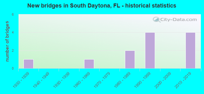
- New bridges - historical statistics
- 11930-1939
- 11960-1969
- 21980-1989
- 41990-1999
- 42010-2019


- Bridge Condition - Deck
- 20.0%Very good
- 60.0%Good
- 20.0%Satisfactory

- Bridge Condition - Superstructure
- 40.0%Very good
- 60.0%Good

- Bridge Condition - Substructure
- 40.0%Very good
- 20.0%Good
- 20.0%Satisfactory
- 20.0%Fair

- Bridge Condition - Channel
- 33.3%Very good
- 50.0%Good
- 8.3%Satisfactory
- 8.3%Fair

- Bridge Condition - Culverts
- 14.3%Very good
- 85.7%Good
Find on map >> Show street view
Structure Number: 790012, Location: US-1 over Reed Canal (Lat: 29.158514, Lng: -80.995217), Route carried "on" structure: US 1, Year Built: 1931, Year Reconstructed: 1960, Status: Open, Structure Length: 2.81m (9.22ft), Average Daily Traffic: 24,000 (year 2020), Truck Traffic: 6%, Average Future Daily Traffic: 41,640 (year 2042), Design Load: H 15, Features Intersected: Reed Canal
Minimum Vertical Clearance: 30+ m (98+ ft), Kilometerpoint: 46.206, Lanes on structure: 5, Base Highway Network: Yes, Owner: State Highway Agency, Approaching Roadway Width: 24.6m (80.7ft), Skew: 20 degrees, Material/Design: Concrete, Design/Construction: Slab, Number Of Spans In Main Unit: 4, Length of Maximum Span: 7.0m (23.0ft), Curb or Sidewalk Widths: Left: 1.5m (4.9ft), Right: 1.5m (4.9ft), Curb-To-Curb Width: 24.6m (80.7ft), Out-to-Out Width: 29.1m (95.5ft)
Condition: Deck: Good, Superstructure: Good, Substructure: Satisfactory, Channel: Good, Operating Rating: 48.3 metric tons, Method Used To Determine Operating Rating: Load Factor (LF), Inventory Rating: 28.8 metric tons, Method Used To Determine Inventory Rating: Load Factor (LF), Structural Evaluation: Equal to present minimum criteria, Deck Geometry: Superior to present desirable criteria, Waterway Adequacy: Equal to present desirable criteria, Approach Roadway Alignment: Equal to present desirable criteria, Designated Inspection Frequency: Every 24 months, Underwater Inspection Frequency: Every 24 months, Inspection Date: May 2021, Underwater Inspection Date: May 2021, Deck Structure Type: Concrete Cast-file-Place, Wearing Surface/Protective System: Wearing Surface: Bituminous
Find on map >> Show street view
Structure Number: 790177, Location: SR-5A over Nova Canal (Lat: 29.154472, Lng: -81.019694), Route carried "on" structure: State highway 5A, Year Built: 1998, Status: Open, Structure Length: 1.16m (3.81ft), Average Daily Traffic: 9,000 (year 2020), Truck Traffic: 6%, Average Future Daily Traffic: 15,615 (year 2042), Design Load: HS 20+Mod, Features Intersected: Nova Canal
Minimum Vertical Clearance: 30+ m (98+ ft), Kilometerpoint: 7.353, Lanes on structure: 3, Owner: State Highway Agency, Approaching Roadway Width: 29.0m (95.1ft), Material/Design: Concrete, Design/Construction: Culvert, Number Of Spans In Main Unit: 3, Length of Maximum Span: 3.7m (12.1ft)
Condition: Channel: Satisfactory, Culverts: Good, Operating Rating: 81.3 metric tons, Method Used To Determine Operating Rating: Load Factor (LF), Inventory Rating: 48.7 metric tons, Method Used To Determine Inventory Rating: Load Factor (LF), Structural Evaluation: Better than present minimum criteria, Waterway Adequacy: Equal to present desirable criteria, Approach Roadway Alignment: Equal to present desirable criteria, Designated Inspection Frequency: Every 24 months, Underwater Inspection Frequency: Every 24 months, Inspection Date: November 2021, Underwater Inspection Date: November 2021
Find on map >> Show street view
Structure Number: 790178, Location: SR-5A over Nova Canal (Lat: 29.160958, Lng: -81.022981), Route carried "on" structure: State highway 5A, Year Built: 1998, Status: Open, Structure Length: 1.07m (3.51ft), Average Daily Traffic: 14,250 (year 2020), Truck Traffic: 5%, Average Future Daily Traffic: 24,724 (year 2042), Design Load: HS 20+Mod, Features Intersected: Nova Canal
Minimum Vertical Clearance: 30+ m (98+ ft), Kilometerpoint: 8.118, Lanes on structure: 2, Base Highway Network: Yes, Owner: State Highway Agency, Approaching Roadway Width: 19.1m (62.7ft), Material/Design: Concrete, Design/Construction: Culvert, Number Of Spans In Main Unit: 3, Length of Maximum Span: 3.3m (10.8ft)
Condition: Channel: Good, Culverts: Good, Inventory Rating: 58.3 metric tons, Method Used To Determine Inventory Rating: Load Factor (LF), Structural Evaluation: Better than present minimum criteria, Waterway Adequacy: Equal to present desirable criteria, Approach Roadway Alignment: Equal to present desirable criteria, Designated Inspection Frequency: Every 24 months, Underwater Inspection Frequency: Every 24 months, Inspection Date: November 2021, Underwater Inspection Date: November 2021
Find on map >> Show street view
Structure Number: 790183, Location: 0.4 Mi. S. of Beville Rd (Lat: 29.170467, Lng: -81.025867), Route carried "on" structure: State highway 5A, Year Built: 1998, Status: Open, Structure Length: 0.91m (2.99ft), Average Daily Traffic: 14,250 (year 2020), Truck Traffic: 5%, Average Future Daily Traffic: 24,724 (year 2042), Design Load: HS 20+Mod, Features Intersected: Nova Canal
Minimum Vertical Clearance: 30+ m (98+ ft), Kilometerpoint: 9.230, Lanes on structure: 2, Owner: State Highway Agency, Approaching Roadway Width: 17.9m (58.7ft), Skew: 20 degrees, Material/Design: Concrete, Design/Construction: Culvert, Number Of Spans In Main Unit: 3, Length of Maximum Span: 3.0m (9.8ft)
Condition: Channel: Good, Culverts: Good, Operating Rating: 68.6 metric tons, Method Used To Determine Operating Rating: Load Factor (LF), Inventory Rating: 41.1 metric tons, Method Used To Determine Inventory Rating: Load Factor (LF), Structural Evaluation: Better than present minimum criteria, Waterway Adequacy: Superior to present desirable criteria, Approach Roadway Alignment: Equal to present desirable criteria, Designated Inspection Frequency: Every 24 months, Underwater Inspection Frequency: Every 24 months, Inspection Date: December 2021, Underwater Inspection Date: December 2021
Find on map >> Show street view
Structure Number: 790184, Location: SR-5A over Nova Canal (Lat: 29.173392, Lng: -81.027442), Route carried "on" structure: State highway 5A, Year Built: 1998, Status: Open, Structure Length: 0.98m (3.22ft), Average Daily Traffic: 14,250 (year 2020), Truck Traffic: 5%, Average Future Daily Traffic: 24,724 (year 2042), Design Load: HS 20+Mod, Features Intersected: Nova Canal
Minimum Vertical Clearance: 30+ m (98+ ft), Kilometerpoint: 9.494, Lanes on structure: 3, Owner: State Highway Agency, Approaching Roadway Width: 12.8m (42.0ft), Skew: 6 degrees, Material/Design: Concrete, Design/Construction: Culvert, Number Of Spans In Main Unit: 3, Length of Maximum Span: 3.0m (9.8ft)
Condition: Channel: Good, Culverts: Good, Operating Rating: 68.5 metric tons, Method Used To Determine Operating Rating: Load Factor (LF), Inventory Rating: 41.1 metric tons, Method Used To Determine Inventory Rating: Load Factor (LF), Structural Evaluation: Better than present minimum criteria, Waterway Adequacy: Equal to present desirable criteria, Approach Roadway Alignment: Equal to present desirable criteria, Designated Inspection Frequency: Every 24 months, Underwater Inspection Frequency: Every 24 months, Inspection Date: November 2021, Underwater Inspection Date: November 2021
Find on map >> Show street view
Structure Number: 790201, Location: I-4 EB over Tomoka River (Lat: 29.150333, Lng: -81.087250), Route carried "on" structure: Interstate 4, Year Built: 2014, Status: Open, Structure Length: 7.70m (25.26ft), Average Daily Traffic: 25,500 (year 2020), Truck Traffic: 19%, Average Future Daily Traffic: 44,242 (year 2042), Design Load: HL 93, Features Intersected: Tomoka River
Minimum Vertical Clearance: 30.45m (99.90ft), Kilometerpoint: 43.275, Lanes on structure: 3, Base Highway Network: Yes, Owner: State Highway Agency, Approaching Roadway Width: 14.6m (47.9ft), Material/Design: Prestressed concrete, Design/Construction: Stringer/Multi-beam, Number Of Spans In Main Unit: 3, Length of Maximum Span: 25.7m (84.3ft), Curb-To-Curb Width: 14.6m (47.9ft), Out-to-Out Width: 18.0m (59.1ft)
Condition: Deck: Good, Superstructure: Very good, Substructure: Very good, Channel: Very good, Operating Rating: 41.5 metric tons, Method Used To Determine Operating Rating: Load and Resistance Factor (LRFR), Inventory Rating: 37.9 metric tons, Method Used To Determine Inventory Rating: Load and Resistance Factor (LRFR), Structural Evaluation: Equal to present desirable criteria, Deck Geometry: Meets minimum limits, Waterway Adequacy: Equal to present desirable criteria, Approach Roadway Alignment: Equal to present desirable criteria, Designated Inspection Frequency: Every 24 months, Inspection Date: October 2020, Deck Structure Type: Concrete Cast-file-Place, Wearing Surface/Protective System: Wearing Surface: Monolithic Concrete
Find on map >> Show street view
Structure Number: 790202, Location: I-4 WB over Tomoka River (Lat: 29.150778, Lng: -81.090194), Route carried "on" structure: Interstate 4, Year Built: 2014, Status: Open, Structure Length: 7.76m (25.46ft), Average Daily Traffic: 32,750 (year 2018), Truck Traffic: 16%, Average Future Daily Traffic: 56,821 (year 2040), Design Load: HL 93, Features Intersected: Tomoka River
Minimum Vertical Clearance: 30.45m (99.90ft), Kilometerpoint: 43.275, Lanes on structure: 3, Base Highway Network: Yes, Owner: State Highway Agency, Approaching Roadway Width: 14.6m (47.9ft), Material/Design: Prestressed concrete, Design/Construction: Stringer/Multi-beam, Number Of Spans In Main Unit: 3, Length of Maximum Span: 25.7m (84.3ft), Curb-To-Curb Width: 14.6m (47.9ft), Out-to-Out Width: 18.0m (59.1ft)
Condition: Deck: Very good, Superstructure: Very good, Substructure: Very good, Channel: Very good, Operating Rating: 41.5 metric tons, Method Used To Determine Operating Rating: Load and Resistance Factor (LRFR), Inventory Rating: 37.9 metric tons, Method Used To Determine Inventory Rating: Load and Resistance Factor (LRFR), Structural Evaluation: Equal to present desirable criteria, Deck Geometry: Meets minimum limits, Waterway Adequacy: Equal to present desirable criteria, Approach Roadway Alignment: Equal to present desirable criteria, Designated Inspection Frequency: Every 24 months, Inspection Date: October 2020, Deck Structure Type: Concrete Cast-file-Place, Wearing Surface/Protective System: Wearing Surface: Monolithic Concrete
Find on map >> Show street view
Structure Number: 794154, Location: SR-5A - Big Tree Rd (Lat: 29.166206, Lng: -81.023567), Route carried "on" structure: State highway 5A, Year Built: 1988, Status: Open, Structure Length: 0.94m (3.08ft), Average Daily Traffic: 14,250 (year 2020), Truck Traffic: 5%, Average Future Daily Traffic: 24,724 (year 2042), Design Load: HS 20+Mod, Features Intersected: Nova Canal, Facility Carried by Structure: Big Tree Road
Minimum Vertical Clearance: 30+ m (98+ ft), Kilometerpoint: 8.716, Lanes on structure: 2, Owner: State Highway Agency, Approaching Roadway Width: 16.2m (53.1ft), Material/Design: Concrete, Design/Construction: Culvert, Number Of Spans In Main Unit: 3, Length of Maximum Span: 3.0m (9.8ft)
Condition: Channel: Good, Culverts: Good, Operating Rating: 75.7 metric tons, Method Used To Determine Operating Rating: Load Factor (LF), Inventory Rating: 45.4 metric tons, Method Used To Determine Inventory Rating: Load Factor (LF), Structural Evaluation: Better than present minimum criteria, Waterway Adequacy: Equal to present desirable criteria, Approach Roadway Alignment: Equal to present desirable criteria, Designated Inspection Frequency: Every 24 months, Underwater Inspection Frequency: Every 24 months, Inspection Date: November 2021, Underwater Inspection Date: November 2021
Find on map >> Show street view
Structure Number: 7965, Location: Intrsect w Reed Canal Rd (Lat: 29.155700, Lng: -81.016347), Route carried "on" structure: City street , Year Built: 1983, Status: Posted for load, Structure Length: 1.74m (5.71ft), Average Daily Traffic: 6,700 (year 2021), Truck Traffic: 5%, Average Future Daily Traffic: 11,624 (year 2042), Design Load: H 15, Features Intersected: Reed Canal, Facility Carried by Structure: Reed Ca Prk Ent Rd
Minimum Vertical Clearance: 30+ m (98+ ft), Kilometerpoint: 2.028, Lanes on structure: 2, Owner: City or Municipal Highway Agency, Approaching Roadway Width: 6.1m (20.0ft), Material/Design: Wood or Timber, Design/Construction: Stringer/Multi-beam, Number Of Spans In Main Unit: 4, Length of Maximum Span: 4.8m (15.7ft), Curb or Sidewalk Widths: Left: 0.0m, Right: 2.0m (6.6ft), Curb-To-Curb Width: 7.6m (24.9ft), Out-to-Out Width: 10.1m (33.1ft)
Condition: Deck: Satisfactory, Superstructure: Good, Substructure: Fair, Channel: Fair, Operating Rating: 19.8 metric tons, Method Used To Determine Operating Rating: Allowable Stress (AS), Inventory Rating: 14.9 metric tons, Method Used To Determine Inventory Rating: Allowable Stress (AS), Structural Evaluation: High priority of corrective action, Deck Geometry: High priority of replacement, Waterway Adequacy: Equal to present desirable criteria, Approach Roadway Alignment: Equal to present desirable criteria, Bridge Posting: Required (Relationship of Operating Rating to Maximum Legal Load: 20.0 - 29.9% below), Designated Inspection Frequency: Every 24 months, Underwater Inspection Frequency: Every 24 months, Other Special Inspection Frequency: Every 12 months, Inspection Date: May 2020, Underwater Inspection Date: May 2020, Other Special Inspection Date: May 2021, Deck Structure Type: Wood or Timber, Wearing Surface/Protective System: Wearing Surface: Wood or Timber
Find on map >> Show street view
Structure Number: 796518, Location: At Reed Canal Road (Lat: 29.158181, Lng: -81.010253), Route carried "on" structure: City street , Year Built: 1965, Status: Posted for load, Structure Length: 1.22m (4.00ft), Average Daily Traffic: 2,753 (year 2020), Truck Traffic: 5%, Average Future Daily Traffic: 4,777 (year 2042), Design Load: HS 20, Features Intersected: Reed Canal, Facility Carried by Structure: Sauls Street
Minimum Vertical Clearance: 30+ m (98+ ft), Kilometerpoint: 0.085, Lanes on structure: 2, Owner: City or Municipal Highway Agency, Approaching Roadway Width: 9.5m (31.2ft), Material/Design: Prestressed concrete, Design/Construction: Tee Beam, Number Of Spans In Main Unit: 1, Length of Maximum Span: 12.2m (40.0ft), Curb or Sidewalk Widths: Left: 0.5m (1.6ft), Right: 1.9m (6.2ft), Curb-To-Curb Width: 9.5m (31.2ft), Out-to-Out Width: 15.2m (49.9ft)
Condition: Deck: Good, Superstructure: Good, Substructure: Good, Channel: Good, Operating Rating: 31.9 metric tons, Method Used To Determine Operating Rating: Load and Resistance Factor (LRFR), Inventory Rating: 24.8 metric tons, Method Used To Determine Inventory Rating: Load and Resistance Factor (LRFR), Structural Evaluation: Equal to present minimum criteria, Deck Geometry: Meets minimum limits, Waterway Adequacy: Equal to present minimum criteria, Approach Roadway Alignment: Equal to present desirable criteria, Designated Inspection Frequency: Every 24 months, Inspection Date: May 2020, Deck Structure Type: Concrete Cast-file-Place, Wearing Surface/Protective System: Wearing Surface: Bituminous
Find on map >> Show street view
Structure Number: 796548, Location: At Reed Canal Rd (Lat: 29.158378, Lng: -81.003128), Route carried "on" structure: City street , Year Built: 2012, Status: Open, Structure Length: 1.48m (4.86ft), Average Daily Traffic: 3,245 (year 2020), Truck Traffic: 5%, Average Future Daily Traffic: 5,631 (year 2042), Design Load: HL 93, Features Intersected: Reed Canal, Facility Carried by Structure: Oak Lea Drive
Minimum Vertical Clearance: 30+ m (98+ ft), Kilometerpoint: 0.113, Lanes on structure: 2, Owner: City or Municipal Highway Agency, Approaching Roadway Width: 8.1m (26.6ft), Material/Design: Concrete, Design/Construction: Culvert, Number Of Spans In Main Unit: 1, Length of Maximum Span: 14.8m (48.6ft)
Condition: Channel: Very good, Culverts: Good, Operating Rating: 46.7 metric tons, Method Used To Determine Operating Rating: Load and Resistance Factor (LRFR), Inventory Rating: 36.4 metric tons, Method Used To Determine Inventory Rating: Load and Resistance Factor (LRFR), Structural Evaluation: Better than present minimum criteria, Waterway Adequacy: Equal to present desirable criteria, Approach Roadway Alignment: Somewhat better than minimum adequacy, Designated Inspection Frequency: Every 24 months, Inspection Date: May 2020
Find on map >> Show street view
Structure Number: 796549, Location: CR-4078 & Lantern Park Dr (Lat: 29.158389, Lng: -81.006806), Route carried "on" structure: City street , Year Built: 2016, Status: Open, Structure Length: 1.40m (4.59ft), Average Daily Traffic: 3,029 (year 2020), Truck Traffic: 3%, Average Future Daily Traffic: 3,665 (year 2042), Design Load: HL 93, Features Intersected: Reed Canal, Facility Carried by Structure: Lantern Park Drive
Minimum Vertical Clearance: 30.45m (99.90ft), Kilometerpoint: 0.154, Lanes on structure: 2, Owner: City or Municipal Highway Agency, Approaching Roadway Width: 7.3m (24.0ft), Material/Design: Concrete, Design/Construction: Culvert, Number Of Spans In Main Unit: 1, Length of Maximum Span: 13.7m (44.9ft), Curb or Sidewalk Widths: Left: 1.8m (5.9ft), Right: 1.8m (5.9ft)
Condition: Channel: Very good, Culverts: Very good, Operating Rating: 50.3 metric tons, Method Used To Determine Operating Rating: Load and Resistance Factor (LRFR), Inventory Rating: 39.2 metric tons, Method Used To Determine Inventory Rating: Load and Resistance Factor (LRFR), Structural Evaluation: Equal to present desirable criteria, Waterway Adequacy: Superior to present desirable criteria, Approach Roadway Alignment: Equal to present desirable criteria, Designated Inspection Frequency: Every 24 months, Underwater Inspection Frequency: Every 24 months, Inspection Date: August 2020, Underwater Inspection Date: August 2020