Bridge Statistics for Somerville, Massachusetts (MA)
Condition, Traffic, Stress, Structural Evaluation, Project Costs
- National Bridge Inventory (NBI) Statistics
- 26Number of bridges
- 738ft / 225mTotal length
- $313,594,000Total costs
- 764,503Total average daily traffic
- 72,305Total average daily truck traffic
- 933,067Total future (year 2031) average daily traffic
- National Bridge Inventory (NBI) Registered Bridges for Somerville
- No street view available for this location
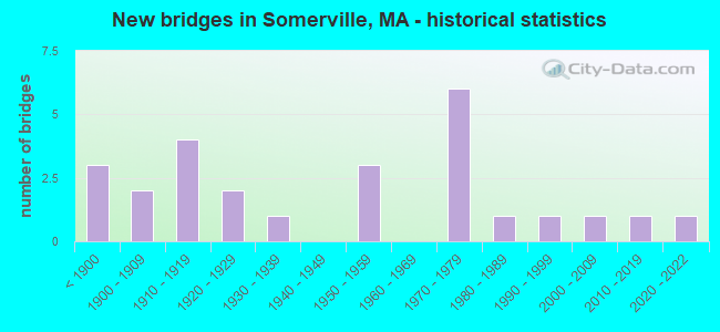
- New bridges - historical statistics
- 3Before 1900
- 21900-1909
- 41910-1919
- 21920-1929
- 11930-1939
- 31950-1959
- 61970-1979
- 11980-1989
- 11990-1999
- 12000-2009
- 12010-2019
- 12020-2022

- Reconstructed bridges - Historical Statistics
- 51970-1979
- 31980-1989
- 21990-1999
- 32000-2009
- 12010-2019


- Bridge Condition - Deck
- 30.8%Good
- 42.3%Satisfactory
- 26.9%Fair

- Bridge Condition - Superstructure
- 7.7%Very good
- 23.1%Good
- 38.5%Satisfactory
- 15.4%Fair
- 11.5%Poor
- 3.8%Serious

- Bridge Condition - Substructure
- 3.8%Very good
- 15.4%Good
- 38.5%Satisfactory
- 38.5%Fair
- 3.8%Poor
Find on map >> Show street view
Structure Number: S170053G2DOT634, Location: 1.6 KM S JCT SR28&38 (Lat: 42.382917, Lng: -71.090000), Route carried "on" structure: City street , Year Built: 1928, Year Reconstructed: 2014, Status: Open, Structure Length: 3.44m (11.29ft), Average Daily Traffic: 8,500 (year 2018), Truck Traffic: 5%, Average Future Daily Traffic: 16,267 (year 2032), Design Load: HS 25 or greater, Features Intersected: RR MBTA/BMRR, Facility Carried by Structure: HWY CROSS ST
Minimum Vertical Clearance: 4.57m (14.99ft), Kilometerpoint: 0.000, Lanes on structure: 2, Owner: State Highway Agency, Approaching Roadway Width: 8.5m (27.9ft), Skew: 3 degrees, Material/Design: Steel, Design/Construction: Truss - Thru, Number Of Spans In Main Unit: 1, Length of Maximum Span: 32.9m (107.9ft), Curb or Sidewalk Widths: Left: 1.9m (6.2ft), Right: 1.9m (6.2ft), Curb-To-Curb Width: 8.4m (27.6ft), Out-to-Out Width: 14.3m (46.9ft)
Condition: Deck: Good, Superstructure: Good, Substructure: Good, Operating Rating: 95.9 metric tons, Method Used To Determine Operating Rating: Load Factor (LF), Inventory Rating: 57.4 metric tons, Method Used To Determine Inventory Rating: Load Factor (LF), Structural Evaluation: Better than present minimum criteria, Deck Geometry: High priority of replacement, Underclear: High priority of corrective action, Approach Roadway Alignment: High priority of corrective action, Designated Inspection Frequency: Every 24 months, Critical Feature Inspection Frequency: Every 24 months, Inspection Date: September 2020, Critical Feature Inspection Date: September 2020, Deck Structure Type: Concrete Cast-file-Place, Wearing Surface/Protective System: Wearing Surface: Bituminous
Find on map >> Show street view
Structure Number: S170063G3DOT634, Location: 1.1 KM SW JCT SR28&3 (Lat: 42.386381, Lng: -71.093494), Route carried "on" structure: City street , Year Built: 1902, Year Reconstructed: 2003, Status: Open, Structure Length: 2.49m (8.17ft), Average Daily Traffic: 3,900 (year 2019), Truck Traffic: 6%, Average Future Daily Traffic: 6,949 (year 2032), Design Load: HS 20, Features Intersected: RR MBTA/BMRR, Facility Carried by Structure: HWY WALNUT ST
Minimum Vertical Clearance: 30+ m (98+ ft), Kilometerpoint: 0.660, Lanes on structure: 2, Owner: State Highway Agency, Approaching Roadway Width: 7.6m (24.9ft), Skew: 2 degrees, Material/Design: Prestressed concrete, Design/Construction: Box Beam or Girders - Multiple, Number Of Spans In Main Unit: 1, Length of Maximum Span: 23.7m (77.8ft), Curb or Sidewalk Widths: Left: 1.8m (5.9ft), Right: 1.8m (5.9ft), Curb-To-Curb Width: 7.9m (25.9ft), Out-to-Out Width: 12.3m (40.4ft)
Condition: Deck: Satisfactory, Superstructure: Satisfactory, Substructure: Satisfactory, Operating Rating: 73.3 metric tons, Method Used To Determine Operating Rating: Load Factor (LF), Inventory Rating: 48.1 metric tons, Method Used To Determine Inventory Rating: Load Factor (LF), Structural Evaluation: Equal to present minimum criteria, Deck Geometry: High priority of replacement, Underclear: High priority of corrective action, Approach Roadway Alignment: Better than present minimum criteria, Length Of Structure Improvement: 2.50m (8.20ft), Designated Inspection Frequency: Every 24 months, Inspection Date: October 2021, Bridge Improvement Cost: $1,155,000, Roadway Improvement Cost: $116,000, Total Project Cost: $1,733,000 ( Estimate for 2022), Deck Structure Type: Concrete Precast Panels, Wearing Surface/Protective System: Wearing Surface: Latex Concrete, Deck Protection: Epoxy Coated Reinforcing
Find on map >> Show street view
Structure Number: S170073G4DOT634, Location: .7 MI SW OF JCT SR28&38 (Lat: 42.387431, Lng: -71.095403), Route carried "on" structure: City street , Year Built: 1910, Year Reconstructed: 1983, Status: Closed, Structure Length: 4.57m (14.99ft), Average Daily Traffic: 15,000 (year 2017), Truck Traffic: 10%, Average Future Daily Traffic: 19,741 (year 2032), Design Load: HS 20, Features Intersected: RR MBTA/BMRR, Facility Carried by Structure: HWY MEDFORD ST
Minimum Vertical Clearance: 30+ m (98+ ft), Kilometerpoint: 0.370, Lanes on structure: 2, Owner: State Highway Agency, Approaching Roadway Width: 11.0m (36.1ft), Skew: 2 degrees, Material/Design: Steel, Design/Construction: Girder and Floorbeam System, Number Of Spans In Main Unit: 1, Length of Maximum Span: 42.7m (140.1ft), Curb or Sidewalk Widths: Left: 1.7m (5.6ft), Right: 1.6m (5.2ft), Curb-To-Curb Width: 10.1m (33.1ft), Out-to-Out Width: 15.2m (49.9ft)
Condition: Deck: Satisfactory, Superstructure: Satisfactory, Substructure: Fair, Operating Rating: 50.1 metric tons, Method Used To Determine Operating Rating: Allowable Stress (AS), Inventory Rating: 26.4 metric tons, Method Used To Determine Inventory Rating: Allowable Stress (AS), Structural Evaluation: Somewhat better than minimum adequacy, Deck Geometry: Meets minimum limits, Approach Roadway Alignment: Equal to present minimum criteria, Length Of Structure Improvement: 4.60m (15.09ft), Designated Inspection Frequency: Every 24 months, Critical Feature Inspection Frequency: Every 24 months, Inspection Date: October 2021, Critical Feature Inspection Date: October 2021, Bridge Improvement Cost: $2,747,000, Roadway Improvement Cost: $275,000, Total Project Cost: $4,121,000 ( Estimate for 2022), Deck Structure Type: Concrete Cast-file-Place, Wearing Surface/Protective System: Wearing Surface: Bituminous, Membrane: Other
Find on map >> Show street view
Structure Number: S170083G5DOT634, Location: 1.3 KM SW OF JCT SR28&38 (Lat: 42.388439, Lng: -71.097644), Route carried "on" structure: City street , Year Built: 1898, Year Reconstructed: 2001, Status: Open, Structure Length: 2.37m (7.78ft), Average Daily Traffic: 9,700 (year 2018), Truck Traffic: 7%, Average Future Daily Traffic: 14,056 (year 2033), Design Load: HS 20, Features Intersected: RR MBTA/BMRR, Facility Carried by Structure: HWY SCHOOL ST
Minimum Vertical Clearance: 30+ m (98+ ft), Kilometerpoint: 0.756, Lanes on structure: 2, Owner: State Highway Agency, Approaching Roadway Width: 9.7m (31.8ft), Material/Design: Prestressed concrete, Design/Construction: Box Beam or Girders - Multiple, Number Of Spans In Main Unit: 1, Length of Maximum Span: 22.9m (75.1ft), Curb or Sidewalk Widths: Left: 1.8m (5.9ft), Right: 1.8m (5.9ft), Curb-To-Curb Width: 9.7m (31.8ft), Out-to-Out Width: 14.0m (45.9ft)
Condition: Deck: Fair, Superstructure: Fair, Substructure: Satisfactory, Operating Rating: 77.9 metric tons, Method Used To Determine Operating Rating: Load Factor (LF), Inventory Rating: 57.3 metric tons, Method Used To Determine Inventory Rating: Load Factor (LF), Structural Evaluation: Somewhat better than minimum adequacy, Deck Geometry: Meets minimum limits, Underclear: High priority of corrective action, Approach Roadway Alignment: Equal to present desirable criteria, Length Of Structure Improvement: 2.40m (7.87ft), Designated Inspection Frequency: Every 24 months, Inspection Date: January 2022, Bridge Improvement Cost: $1,320,000, Roadway Improvement Cost: $133,000, Total Project Cost: $1,981,000 ( Estimate for 2022), Deck Structure Type: Concrete Precast Panels, Wearing Surface/Protective System: Wearing Surface: Latex Concrete, Membrane: Other, Deck Protection: Epoxy Coated Reinforcing
Find on map >> Show street view
Structure Number: S170093G6DOT634, Location: 1.3 KM W OF JCT SR28&38 (Lat: 42.389747, Lng: -71.100531), Route carried "on" structure: City street , Year Built: 1902, Year Reconstructed: 2006, Status: Open, Structure Length: 2.37m (7.78ft), Average Daily Traffic: 1,160 (year 2018), Truck Traffic: 11%, Average Future Daily Traffic: 2,843 (year 2031), Design Load: HS 20, Features Intersected: RR MBTA/BMRR, Facility Carried by Structure: HWY SYCAMORE ST
Minimum Vertical Clearance: 30+ m (98+ ft), Kilometerpoint: 0.193, Lanes on structure: 1, Owner: State Highway Agency, Approaching Roadway Width: 7.9m (25.9ft), Material/Design: Prestressed concrete, Design/Construction: Box Beam or Girders - Multiple, Number Of Spans In Main Unit: 1, Length of Maximum Span: 22.3m (73.2ft), Curb or Sidewalk Widths: Left: 2.1m (6.9ft), Right: 2.1m (6.9ft), Curb-To-Curb Width: 7.9m (25.9ft), Out-to-Out Width: 12.9m (42.3ft)
Condition: Deck: Good, Superstructure: Good, Substructure: Fair, Operating Rating: 72.1 metric tons, Method Used To Determine Operating Rating: Load Factor (LF), Inventory Rating: 61.1 metric tons, Method Used To Determine Inventory Rating: Load Factor (LF), Structural Evaluation: Somewhat better than minimum adequacy, Deck Geometry: Meets minimum limits, Underclear: High priority of corrective action, Approach Roadway Alignment: Better than present minimum criteria, Length Of Structure Improvement: 2.40m (7.87ft), Designated Inspection Frequency: Every 24 months, Inspection Date: November 2020, Bridge Improvement Cost: $1,217,000, Roadway Improvement Cost: $122,000, Total Project Cost: $1,826,000 ( Estimate for 2022), Deck Structure Type: Concrete Precast Panels, Wearing Surface/Protective System: Wearing Surface: Bituminous, Membrane: Built-up, Deck Protection: Epoxy Coated Reinforcing
Find on map >> Show street view
Structure Number: S170103G7DOT634, Location: 1.6 KM W OF JCT SR28&38 (Lat: 42.390367, Lng: -71.102039), Route carried "on" structure: City street , Year Built: 1889, Year Reconstructed: 1985, Status: Open, Structure Length: 2.41m (7.91ft), Average Daily Traffic: 7,600 (year 2016), Truck Traffic: 5%, Average Future Daily Traffic: 15,793 (year 2031), Design Load: HS 20, Features Intersected: RR MBTA/BMRR, Facility Carried by Structure: HWY CENTRAL ST
Minimum Vertical Clearance: 30+ m (98+ ft), Kilometerpoint: 0.837, Lanes on structure: 2, Owner: State Highway Agency, Approaching Roadway Width: 8.7m (28.5ft), Material/Design: Steel, Design/Construction: Stringer/Multi-beam, Number Of Spans In Main Unit: 1, Length of Maximum Span: 20.7m (67.9ft), Curb or Sidewalk Widths: Left: 1.6m (5.2ft), Right: 1.6m (5.2ft), Curb-To-Curb Width: 8.7m (28.5ft), Out-to-Out Width: 12.4m (40.7ft)
Condition: Deck: Satisfactory, Superstructure: Good, Substructure: Satisfactory, Operating Rating: 75.6 metric tons, Method Used To Determine Operating Rating: Load Factor (LF), Inventory Rating: 45.3 metric tons, Method Used To Determine Inventory Rating: Load Factor (LF), Structural Evaluation: Equal to present minimum criteria, Deck Geometry: High priority of replacement, Underclear: High priority of corrective action, Approach Roadway Alignment: Equal to present desirable criteria, Length Of Structure Improvement: 2.50m (8.20ft), Designated Inspection Frequency: Every 24 months, Inspection Date: October 2020, Bridge Improvement Cost: $1,108,000, Roadway Improvement Cost: $111,000, Total Project Cost: $1,663,000 ( Estimate for 2022), Deck Structure Type: Concrete Cast-file-Place, Wearing Surface/Protective System: Wearing Surface: Bituminous, Membrane: Built-up, Deck Protection: Epoxy Coated Reinforcing
Find on map >> Show street view
Structure Number: S17011AW2DOT634, Location: 1.8 KM NW OF JCT SR28&38 (Lat: 42.393186, Lng: -71.105842), Route carried "on" structure: City street , Year Built: 2006, Status: Open, Structure Length: 2.59m (8.50ft), Average Daily Traffic: 6,077 (year 2018), Truck Traffic: 4%, Average Future Daily Traffic: 3,948 (year 2031), Design Load: HS 20, Features Intersected: RR MBTA/BMRR, Facility Carried by Structure: HWY LOWELL ST
Minimum Vertical Clearance: 30+ m (98+ ft), Kilometerpoint: 0.000, Lanes on structure: 2, Owner: State Highway Agency, Approaching Roadway Width: 7.3m (24.0ft), Skew: 3 degrees, Material/Design: Prestressed concrete, Design/Construction: Box Beam or Girders - Multiple, Number Of Spans In Main Unit: 1, Length of Maximum Span: 24.5m (80.4ft), Curb or Sidewalk Widths: Left: 1.8m (5.9ft), Right: 1.8m (5.9ft), Curb-To-Curb Width: 7.9m (25.9ft), Out-to-Out Width: 12.4m (40.7ft)
Condition: Deck: Good, Superstructure: Good, Substructure: Good, Operating Rating: 59.1 metric tons, Method Used To Determine Operating Rating: Load Factor (LF), Inventory Rating: 49.6 metric tons, Method Used To Determine Inventory Rating: Load Factor (LF), Structural Evaluation: Better than present minimum criteria, Deck Geometry: High priority of replacement, Underclear: High priority of corrective action, Approach Roadway Alignment: Equal to present desirable criteria, Length Of Structure Improvement: 2.60m (8.53ft), Designated Inspection Frequency: Every 24 months, Inspection Date: October 2020, Bridge Improvement Cost: $1,349,000, Roadway Improvement Cost: $135,000, Total Project Cost: $2,024,000 ( Estimate for 2022), Deck Structure Type: Concrete Cast-file-Place, Wearing Surface/Protective System: Wearing Surface: Integral Concrete, Membrane: Other, Deck Protection: Other
Find on map >> Show street view
Structure Number: S17012AE7DOT634, Location: 1.9 KM NW OF JCT SR28&38 (Lat: 42.397147, Lng: -71.108889), Route carried "on" structure: City street , Year Built: 1999, Status: Open, Structure Length: 2.37m (7.78ft), Average Daily Traffic: 9,400 (year 2017), Truck Traffic: 7%, Average Future Daily Traffic: 13,424 (year 2032), Design Load: HS 20, Features Intersected: RR MBTA/BMRR, Facility Carried by Structure: HWY CEDAR ST
Minimum Vertical Clearance: 30+ m (98+ ft), Kilometerpoint: 0.724, Lanes on structure: 2, Owner: State Highway Agency, Approaching Roadway Width: 7.9m (25.9ft), Skew: 3 degrees, Material/Design: Prestressed concrete, Design/Construction: Box Beam or Girders - Multiple, Number Of Spans In Main Unit: 1, Length of Maximum Span: 22.2m (72.8ft), Curb or Sidewalk Widths: Left: 1.6m (5.2ft), Right: 1.6m (5.2ft), Curb-To-Curb Width: 7.9m (25.9ft), Out-to-Out Width: 11.8m (38.7ft)
Condition: Deck: Satisfactory, Superstructure: Satisfactory, Substructure: Fair, Operating Rating: 68.4 metric tons, Method Used To Determine Operating Rating: Load Factor (LF), Inventory Rating: 41.0 metric tons, Method Used To Determine Inventory Rating: Load Factor (LF), Structural Evaluation: Somewhat better than minimum adequacy, Deck Geometry: High priority of replacement, Underclear: High priority of corrective action, Approach Roadway Alignment: Better than present minimum criteria, Length Of Structure Improvement: 2.40m (7.87ft), Designated Inspection Frequency: Every 24 months, Inspection Date: October 2021, Bridge Improvement Cost: $1,113,000, Roadway Improvement Cost: $112,000, Total Project Cost: $1,670,000 ( Estimate for 2022), Deck Structure Type: Concrete Precast Panels, Wearing Surface/Protective System: Wearing Surface: Bituminous, Membrane: Built-up, Deck Protection: Epoxy Coated Reinforcing
Find on map >> Show street view
Structure Number: S17013BGEDOTNBI, Location: 2.4 KM NW OF JCT SR28&38 (Lat: 42.399450, Lng: -71.110589), Route carried "on" structure: City street , Year Built: 2020, Status: Open, Structure Length: 4.57m (14.99ft), Average Daily Traffic: 28,000 (year 2008), Truck Traffic: 7%, Design Load: HL 93, Features Intersected: RR MBTA/BMRR, Facility Carried by Structure: HWY BROADWAY
Minimum Vertical Clearance: 30+ m (98+ ft), Kilometerpoint: 3.138, Lanes on structure: 2, Owner: State Highway Agency, Approaching Roadway Width: 21.3m (69.9ft), Skew: 3 degrees, Material/Design: Steel continuous, Design/Construction: Girder and Floorbeam System, Number Of Spans In Main Unit: 2, Length of Maximum Span: 28.2m (92.5ft), Curb or Sidewalk Widths: Left: 3.0m (9.8ft), Right: 2.7m (8.9ft), Curb-To-Curb Width: 21.3m (69.9ft), Out-to-Out Width: 27.0m (88.6ft)
Condition: Deck: Good, Superstructure: Very good, Substructure: Very good, Operating Rating: 42.1 metric tons, Method Used To Determine Operating Rating: Assigned ratings based on Load and Resistance Factor Design (LRFD) reported by rating factor (RF) using HL93 loadings, Inventory Rating: 32.4 metric tons, Method Used To Determine Inventory Rating: Assigned ratings based on Load and Resistance Factor Design (LRFD) reported by rating factor (RF) using HL93 loadings, Structural Evaluation: Equal to present desirable criteria, Deck Geometry: Superior to present desirable criteria, Approach Roadway Alignment: Superior to present desirable criteria, Designated Inspection Frequency: Every 24 months, Inspection Date: August 2021, Deck Structure Type: Concrete Cast-file-Place, Wearing Surface/Protective System: Wearing Surface: Bituminous
Find on map >> Show street view
Structure Number: S170153GGDOT634, Location: 1.5 MI SW OF JCT SR28&38 (Lat: 42.392778, Lng: -71.106167), Route carried "on" structure: City street , Year Built: 1910, Year Reconstructed: 2006, Status: Open, Structure Length: 1.46m (4.79ft), Average Daily Traffic: 6,000 (year 2018), Truck Traffic: 2%, Average Future Daily Traffic: 3,948 (year 2031), Design Load: HS 20, Features Intersected: RR BMRR SPUR, Facility Carried by Structure: HWY LOWELL ST
Minimum Vertical Clearance: 30+ m (98+ ft), Kilometerpoint: 0.998, Lanes on structure: 2, Owner: State Highway Agency, Approaching Roadway Width: 7.3m (24.0ft), Material/Design: Prestressed concrete, Design/Construction: Box Beam or Girders - Multiple, Number Of Spans In Main Unit: 1, Length of Maximum Span: 13.4m (44.0ft), Curb or Sidewalk Widths: Left: 1.9m (6.2ft), Right: 1.9m (6.2ft), Curb-To-Curb Width: 7.2m (23.6ft), Out-to-Out Width: 12.3m (40.4ft)
Condition: Deck: Good, Superstructure: Very good, Substructure: Satisfactory, Operating Rating: 76.5 metric tons, Method Used To Determine Operating Rating: Load Factor (LF), Inventory Rating: 57.5 metric tons, Method Used To Determine Inventory Rating: Load Factor (LF), Structural Evaluation: Equal to present minimum criteria, Deck Geometry: High priority of replacement, Approach Roadway Alignment: Equal to present desirable criteria, Length Of Structure Improvement: 1.50m (4.92ft), Designated Inspection Frequency: Every 24 months, Inspection Date: October 2020, Bridge Improvement Cost: $877,000, Roadway Improvement Cost: $88,000, Total Project Cost: $1,316,000 ( Estimate for 2022), Deck Structure Type: Concrete Cast-file-Place, Wearing Surface/Protective System: Wearing Surface: Monolithic Concrete, Membrane: Built-up, Deck Protection: Epoxy Coated Reinforcing
Find on map >> Show street view
Structure Number: S170163GFDOT634, Location: OVER RAILROAD (Lat: 42.377797, Lng: -71.095817), Route carried "on" structure: City street , Year Built: 1911, Status: Posted for load, Structure Length: 2.91m (9.55ft), Average Daily Traffic: 27,350 (year 2017), Truck Traffic: 8%, Average Future Daily Traffic: 17,609 (year 2032), Features Intersected: RR MBTA/BMRR, Facility Carried by Structure: HWY WEBSTER AVE
Minimum Vertical Clearance: 30+ m (98+ ft), Kilometerpoint: 0.241, Lanes on structure: 4, Owner: State Highway Agency, Approaching Roadway Width: 8.7m (28.5ft), Skew: 9 degrees, Material/Design: Steel, Design/Construction: Girder and Floorbeam System, Number Of Spans In Main Unit: 1, Length of Maximum Span: 27.1m (88.9ft), Curb or Sidewalk Widths: Left: 1.8m (5.9ft), Right: 2.3m (7.5ft), Curb-To-Curb Width: 12.2m (40.0ft), Out-to-Out Width: 21.0m (68.9ft)
Condition: Deck: Fair, Superstructure: Serious, Substructure: Fair, Operating Rating: 27.3 metric tons, Method Used To Determine Operating Rating: Load Factor (LF), Inventory Rating: 17.6 metric tons, Method Used To Determine Inventory Rating: Load Factor (LF), Structural Evaluation: High priority of corrective action, Deck Geometry: High priority of replacement, Underclear: High priority of replacement, Approach Roadway Alignment: High priority of corrective action, Length Of Structure Improvement: 3.90m (12.80ft), Designated Inspection Frequency: Every 6 months, Critical Feature Inspection Frequency: Every 24 months, Other Special Inspection Frequency: Every 6 months, Inspection Date: September 2021, Critical Feature Inspection Date: September 2021, Other Special Inspection Date: September 2021, Bridge Improvement Cost: $6,313,000, Roadway Improvement Cost: $632,000, Total Project Cost: $9,470,000 ( Estimate for 2022), Deck Structure Type: Concrete Cast-file-Place, Wearing Surface/Protective System: Wearing Surface: Bituminous
Find on map >> Show street view
Structure Number: S170173GEDOT634, Location: 2.4 KM N OF HARVARD BR. (Lat: 42.379397, Lng: -71.098783), Route carried "on" structure: City street , Year Built: 1982, Status: Open, Structure Length: 1.98m (6.50ft), Average Daily Traffic: 13,500 (year 2018), Truck Traffic: 10%, Average Future Daily Traffic: 48,169 (year 2031), Design Load: HS 20, Features Intersected: RR MBTA/BMRR, Facility Carried by Structure: HWY WASHNGTON ST
Minimum Vertical Clearance: 30+ m (98+ ft), Kilometerpoint: 0.724, Lanes on structure: 2, Owner: State Highway Agency, Approaching Roadway Width: 12.2m (40.0ft), Skew: 4 degrees, Material/Design: Steel, Design/Construction: Girder and Floorbeam System, Number Of Spans In Main Unit: 1, Length of Maximum Span: 18.0m (59.1ft), Curb or Sidewalk Widths: Left: 2.0m (6.6ft), Right: 1.5m (4.9ft), Curb-To-Curb Width: 12.2m (40.0ft), Out-to-Out Width: 18.1m (59.4ft)
Condition: Deck: Satisfactory, Superstructure: Satisfactory, Substructure: Fair, Operating Rating: 67.1 metric tons, Method Used To Determine Operating Rating: Load Factor (LF), Inventory Rating: 40.2 metric tons, Method Used To Determine Inventory Rating: Load Factor (LF), Structural Evaluation: Somewhat better than minimum adequacy, Deck Geometry: Somewhat better than minimum adequacy, Underclear: High priority of corrective action, Approach Roadway Alignment: Better than present minimum criteria, Length Of Structure Improvement: 2.00m (6.56ft), Designated Inspection Frequency: Every 24 months, Critical Feature Inspection Frequency: Every 24 months, Inspection Date: October 2020, Critical Feature Inspection Date: October 2020, Bridge Improvement Cost: $1,422,000, Roadway Improvement Cost: $143,000, Total Project Cost: $2,134,000 ( Estimate for 2022), Deck Structure Type: Concrete Cast-file-Place, Wearing Surface/Protective System: Wearing Surface: Bituminous, Membrane: Built-up, Deck Protection: Epoxy Coated Reinforcing
Find on map >> Show street view
Structure Number: S170183GDDOT634, Location: 3.2 KM N OF HARVARD BR. (Lat: 42.380936, Lng: -71.104319), Route carried "on" structure: City street , Year Built: 1913, Year Reconstructed: 1993, Status: Open, Structure Length: 2.33m (7.64ft), Average Daily Traffic: 10,900 (year 2019), Truck Traffic: 10%, Average Future Daily Traffic: 15,319 (year 2032), Design Load: HS 20, Features Intersected: RR MBTA/BMRR, Facility Carried by Structure: HWY DANE ST
Minimum Vertical Clearance: 30+ m (98+ ft), Kilometerpoint: 0.209, Lanes on structure: 2, Owner: State Highway Agency, Approaching Roadway Width: 8.2m (26.9ft), Material/Design: Prestressed concrete, Design/Construction: Box Beam or Girders - Multiple, Number Of Spans In Main Unit: 1, Length of Maximum Span: 22.4m (73.5ft), Curb or Sidewalk Widths: Left: 1.9m (6.2ft), Right: 1.5m (4.9ft), Curb-To-Curb Width: 8.5m (27.9ft), Out-to-Out Width: 13.0m (42.7ft)
Condition: Deck: Satisfactory, Superstructure: Satisfactory, Substructure: Fair, Operating Rating: 72.0 metric tons, Method Used To Determine Operating Rating: Allowable Stress (AS), Inventory Rating: 48.1 metric tons, Method Used To Determine Inventory Rating: Allowable Stress (AS), Structural Evaluation: Somewhat better than minimum adequacy, Deck Geometry: High priority of replacement, Underclear: High priority of corrective action, Approach Roadway Alignment: Better than present minimum criteria, Length Of Structure Improvement: 2.40m (7.87ft), Designated Inspection Frequency: Every 24 months, Inspection Date: October 2021, Bridge Improvement Cost: $1,226,000, Roadway Improvement Cost: $123,000, Total Project Cost: $1,840,000 ( Estimate for 2022), Deck Structure Type: Concrete Precast Panels, Wearing Surface/Protective System: Wearing Surface: Bituminous, Membrane: Built-up, Deck Protection: Epoxy Coated Reinforcing
Find on map >> Show street view
Structure Number: S170193GCDOT634, Location: 305 M E OF SR2A (Lat: 42.386756, Lng: -71.116239), Route carried "on" structure: City street , Year Built: 1899, Year Reconstructed: 1992, Status: Open, Structure Length: 1.97m (6.46ft), Average Daily Traffic: 13,250 (year 2018), Truck Traffic: 8%, Average Future Daily Traffic: 16,519 (year 2031), Design Load: HS 20, Features Intersected: RR MBTA/BMRR, Facility Carried by Structure: HWY BEACON ST
Minimum Vertical Clearance: 30+ m (98+ ft), Kilometerpoint: 1.625, Lanes on structure: 3, Base Highway Network: Yes, Owner: State Highway Agency, Approaching Roadway Width: 19.5m (64.0ft), Skew: 3 degrees, Material/Design: Steel, Design/Construction: Frame, Number Of Spans In Main Unit: 1, Length of Maximum Span: 18.5m (60.7ft), Curb or Sidewalk Widths: Left: 3.0m (9.8ft), Right: 3.0m (9.8ft), Curb-To-Curb Width: 15.2m (49.9ft), Out-to-Out Width: 21.9m (71.9ft)
Condition: Deck: Good, Superstructure: Satisfactory, Substructure: Satisfactory, Operating Rating: 60.3 metric tons, Method Used To Determine Operating Rating: Load Factor (LF), Inventory Rating: 36.3 metric tons, Method Used To Determine Inventory Rating: Load Factor (LF), Structural Evaluation: Equal to present minimum criteria, Deck Geometry: Equal to present minimum criteria, Underclear: High priority of corrective action, Approach Roadway Alignment: Equal to present minimum criteria, Length Of Structure Improvement: 2.00m (6.56ft), Designated Inspection Frequency: Every 24 months, Inspection Date: May 2020, Bridge Improvement Cost: $604,000, Roadway Improvement Cost: $61,000, Total Project Cost: $907,000 ( Estimate for 2022), Deck Structure Type: Concrete Cast-file-Place, Wearing Surface/Protective System: Wearing Surface: Bituminous, Membrane: Built-up, Deck Protection: Epoxy Coated Reinforcing
Find on map >> Show street view
Structure Number: S170203GBDOT634, Location: 1.5 MI N OF HARVARD BR. (Lat: 42.377472, Lng: -71.095219), Route carried "on" structure: City street , Year Built: 1933, Year Reconstructed: 1984, Status: Open, Structure Length: 1.22m (4.00ft), Average Daily Traffic: 14,900 (year 2018), Truck Traffic: 11%, Average Future Daily Traffic: 32,534 (year 2033), Design Load: HS 20, Features Intersected: RR MBTA/BMRR, Facility Carried by Structure: HWY PROSPECT ST
Minimum Vertical Clearance: 30+ m (98+ ft), Kilometerpoint: 0.000, Lanes on structure: 2, Base Highway Network: Yes, Owner: State Highway Agency, Approaching Roadway Width: 11.0m (36.1ft), Material/Design: Prestressed concrete, Design/Construction: Box Beam or Girders - Multiple, Number Of Spans In Main Unit: 1, Length of Maximum Span: 11.9m (39.0ft), Curb or Sidewalk Widths: Left: 1.5m (4.9ft), Right: 1.5m (4.9ft), Curb-To-Curb Width: 11.0m (36.1ft), Out-to-Out Width: 14.9m (48.9ft)
Condition: Deck: Fair, Superstructure: Fair, Substructure: Satisfactory, Operating Rating: 77.4 metric tons, Method Used To Determine Operating Rating: Allowable Stress (AS), Inventory Rating: 45.4 metric tons, Method Used To Determine Inventory Rating: Allowable Stress (AS), Structural Evaluation: Somewhat better than minimum adequacy, Deck Geometry: Equal to present minimum criteria, Underclear: High priority of corrective action, Approach Roadway Alignment: Superior to present desirable criteria, Length Of Structure Improvement: 1.30m (4.27ft), Designated Inspection Frequency: Every 24 months, Inspection Date: January 2022, Bridge Improvement Cost: $761,000, Roadway Improvement Cost: $77,000, Total Project Cost: $1,142,000 ( Estimate for 2022), Deck Structure Type: Concrete Precast Panels, Wearing Surface/Protective System: Wearing Surface: Bituminous, Membrane: Preformed Fabric, Deck Protection: Epoxy Coated Reinforcing
Find on map >> Show street view
Structure Number: S170224E2DOTNBI, Location: .1 MI S OF PEARL ST (Lat: 42.384383, Lng: -71.091389), Route carried "on" structure: State highway 28, Year Built: 1926, Year Reconstructed: 1983, Status: Temporarily open, Structure Length: 5.30m (17.39ft), Average Daily Traffic: 53,800 (year 2017), Truck Traffic: 4%, Average Future Daily Traffic: 59,540 (year 2031), Design Load: H 20, Features Intersected: RR MBTA/BMRR
Minimum Vertical Clearance: 4.57m (14.99ft), Kilometerpoint: 200.128, Lanes on structure: 6, Base Highway Network: Yes, Owner: State Highway Agency, Approaching Roadway Width: 25.6m (84.0ft), Skew: 34 degrees, Material/Design: Steel, Design/Construction: Truss - Thru, Number Of Spans In Main Unit: 1, Length of Maximum Span: 52.3m (171.6ft), Curb or Sidewalk Widths: Left: 2.4m (7.9ft), Right: 2.4m (7.9ft), Curb-To-Curb Width: 24.4m (80.1ft), Out-to-Out Width: 32.9m (107.9ft)
Condition: Deck: Satisfactory, Superstructure: Poor, Substructure: Fair, Operating Rating: 10.8 metric tons, Method Used To Determine Operating Rating: Load Factor (LF), Inventory Rating: 6.4 metric tons, Method Used To Determine Inventory Rating: Load Factor (LF), Structural Evaluation: High priority of replacement, Deck Geometry: Somewhat better than minimum adequacy, Underclear: High priority of replacement, Approach Roadway Alignment: Somewhat better than minimum adequacy, Bridge Posting: Required (Relationship of Operating Rating to Maximum Legal Load: > 39.9% below), Length Of Structure Improvement: 6.40m (21.00ft), Designated Inspection Frequency: Every 12 months, Critical Feature Inspection Frequency: Every 24 months, Other Special Inspection Frequency: Every 12 months, Inspection Date: January 2021, Critical Feature Inspection Date: January 2021, Other Special Inspection Date: January 2022, Bridge Improvement Cost: $12,739,000, Roadway Improvement Cost: $1,274,000, Total Project Cost: $19,109,000 ( Estimate for 2022), Deck Structure Type: Concrete Cast-file-Place, Wearing Surface/Protective System: Wearing Surface: Bituminous
Find on map >> Show street view
Structure Number: S170244E3DOTNBI, Location: .1 MI S OF MEDFORD ST (Lat: 42.375444, Lng: -71.085597), Route carried "on" structure: State highway 28, Year Built: 1958, Year Reconstructed: 1983, Status: Temporarily open, Structure Length: 12.19m (39.99ft), Average Daily Traffic: 32,700 (year 2019), Truck Traffic: 10%, Average Future Daily Traffic: 82,124 (year 2032), Design Load: H 20, Features Intersected: COMB POPLAR ST & MBTA
Minimum Vertical Clearance: 30+ m (98+ ft), Kilometerpoint: 0.000, Lanes on structure: 6, Lanes under structure: 1, Base Highway Network: Yes, Owner: State Highway Agency, Approaching Roadway Width: 11.0m (36.1ft), Skew: 20 degrees, Material/Design: Steel, Design/Construction: Girder and Floorbeam System, Number Of Spans In Main Unit: 4, Number Of Approach Spans: 27, Length of Maximum Span: 38.4m (126.0ft), Curb or Sidewalk Widths: Left: 1.7m (5.6ft), Right: 1.7m (5.6ft), Curb-To-Curb Width: 21.9m (71.9ft), Out-to-Out Width: 26.8m (87.9ft)
Condition: Deck: Fair, Superstructure: Poor, Substructure: Poor, Structural Evaluation: High priority of replacement, Deck Geometry: High priority of replacement, Underclear: High priority of replacement, Approach Roadway Alignment: Equal to present desirable criteria, Length Of Structure Improvement: 13.10m (42.98ft), Designated Inspection Frequency: Every 12 months, Critical Feature Inspection Frequency: Every 24 months, Other Special Inspection Frequency: Every 12 months, Inspection Date: July 2021, Critical Feature Inspection Date: July 2021, Other Special Inspection Date: July 2021, Bridge Improvement Cost: $23,605,000, Roadway Improvement Cost: $2,361,000, Total Project Cost: $35,408,000 ( Estimate for 2022), Deck Structure Type: Concrete Cast-file-Place, Wearing Surface/Protective System: Wearing Surface: Bituminous
Find on map >> Show street view
Structure Number: S17025BDWDOTNBI, Location: .1 MI S OF EVERETT AVE (Lat: 42.385167, Lng: -71.091014), Route carried "on" structure: State highway 28, Year Built: 2016, Status: Open, Structure Length: 1.42m (4.66ft), Average Daily Traffic: 45,425 (year 2016), Truck Traffic: 10%, Design Load: HL 93, Features Intersected: HWY GILMAN ST
Minimum Vertical Clearance: 4.57m (14.99ft), Kilometerpoint: 200.189, Lanes on structure: 6, Lanes under structure: 2, Owner: State Highway Agency, Approaching Roadway Width: 27.3m (89.6ft), Skew: 22 degrees, Material/Design: Steel, Design/Construction: Stringer/Multi-beam, Number Of Spans In Main Unit: 1, Length of Maximum Span: 12.9m (42.3ft), Curb or Sidewalk Widths: Left: 2.3m (7.5ft), Right: 2.3m (7.5ft), Curb-To-Curb Width: 27.3m (89.6ft), Out-to-Out Width: 33.4m (109.6ft)
Condition: Deck: Good, Superstructure: Good, Substructure: Good, Operating Rating: 42.1 metric tons, Method Used To Determine Operating Rating: Assigned ratings based on Load and Resistance Factor Design (LRFD) reported by rating factor (RF) using HL93 loadings, Inventory Rating: 32.4 metric tons, Method Used To Determine Inventory Rating: Assigned ratings based on Load and Resistance Factor Design (LRFD) reported by rating factor (RF) using HL93 loadings, Structural Evaluation: Better than present minimum criteria, Deck Geometry: Better than present minimum criteria, Underclear: High priority of corrective action, Approach Roadway Alignment: Equal to present desirable criteria, Designated Inspection Frequency: Every 24 months, Inspection Date: November 2020, Deck Structure Type: Concrete Precast Panels, Wearing Surface/Protective System: Wearing Surface: Bituminous, Deck Protection: Epoxy Coated Reinforcing
Find on map >> Show street view
Structure Number: S170293BNDOTNBI, Location: .8 KM S OF JCT 193&SR16 (Lat: 42.397425, Lng: -71.091064), Route carried "on" structure: Interstate 93, Year Built: 1973, Status: Open, Structure Length: 2.62m (8.60ft), Average Daily Traffic: 147,366 (year 2020), Truck Traffic: 10%, Average Future Daily Traffic: 221,102 (year 2031), Design Load: HS 20, Features Intersected: HWY SHORE DR
Minimum Vertical Clearance: 30+ m (98+ ft), Kilometerpoint: 0.000, Lanes on structure: 8, Lanes under structure: 2, Base Highway Network: Yes, Owner: State Highway Agency, Approaching Roadway Width: 40.8m (133.9ft), Skew: 20 degrees, Material/Design: Steel, Design/Construction: Stringer/Multi-beam, Number Of Spans In Main Unit: 1, Length of Maximum Span: 25.0m (82.0ft), Curb-To-Curb Width: 40.7m (133.5ft), Out-to-Out Width: 42.4m (139.1ft)
Condition: Deck: Fair, Superstructure: Satisfactory, Substructure: Good, Operating Rating: 57.3 metric tons, Method Used To Determine Operating Rating: Load Factor (LF), Inventory Rating: 34.3 metric tons, Method Used To Determine Inventory Rating: Load Factor (LF), Structural Evaluation: Equal to present minimum criteria, Deck Geometry: Superior to present desirable criteria, Underclear: High priority of corrective action, Approach Roadway Alignment: Equal to present desirable criteria, Length Of Structure Improvement: 2.70m (8.86ft), Designated Inspection Frequency: Every 24 months, Inspection Date: August 2020, Bridge Improvement Cost: $2,159,000, Roadway Improvement Cost: $216,000, Total Project Cost: $3,239,000 ( Estimate for 2022), Deck Structure Type: Concrete Cast-file-Place, Wearing Surface/Protective System: Wearing Surface: Bituminous, Membrane: Preformed Fabric, Deck Protection: Epoxy Coated Reinforcing
Find on map >> Show street view
Structure Number: S170313BHDOTNBI, Location: 3.2 KM N OF JCT I93&US1 (Lat: 42.393708, Lng: -71.085833), Route carried "on" structure: Interstate 93, Year Built: 1973, Status: Temporarily open, Structure Length: 71.69m (235.20ft), Average Daily Traffic: 203,588 (year 2018), Truck Traffic: 12%, Average Future Daily Traffic: 228,998 (year 2032), Design Load: HS 20+Mod, Features Intersected: ST 28 & ST38 & TEMPLE ST
Minimum Vertical Clearance: 4.65m (15.26ft), Kilometerpoint: 0.000, Lanes on structure: 8, Lanes under structure: 11, Base Highway Network: Yes, Owner: State Highway Agency, Approaching Roadway Width: 38.1m (125.0ft), Skew: 30 degrees, Material/Design: Steel continuous, Design/Construction: Stringer/Multi-beam, Number Of Spans In Main Unit: 28, Length of Maximum Span: 32.6m (107.0ft), Curb-To-Curb Width: 37.9m (124.3ft), Out-to-Out Width: 42.4m (139.1ft)
Condition: Deck: Fair, Superstructure: Fair, Substructure: Fair, Operating Rating: 43.5 metric tons, Method Used To Determine Operating Rating: Load Factor (LF), Inventory Rating: 26.0 metric tons, Method Used To Determine Inventory Rating: Load Factor (LF), Structural Evaluation: Somewhat better than minimum adequacy, Deck Geometry: High priority of corrective action, Underclear: High priority of corrective action, Approach Roadway Alignment: Equal to present desirable criteria, Length Of Structure Improvement: 71.70m (235.24ft), Designated Inspection Frequency: Every 24 months, Critical Feature Inspection Frequency: Every 24 months, Inspection Date: April 2021, Critical Feature Inspection Date: April 2021, Bridge Improvement Cost: $119,415,000, Roadway Improvement Cost: $11,942,000, Total Project Cost: $179,123,000 ( Estimate for 2022), Deck Structure Type: Concrete Cast-file-Place, Wearing Surface/Protective System: Wearing Surface: Bituminous, Membrane: Built-up, Deck Protection: Other Coated Reinforcing
Find on map >> Show street view
Structure Number: S170333BLDOTNBI, Location: 3.2 KM N OF JCT I93&US1 (Lat: 42.392556, Lng: -71.084200), Route carried "on" structure: Ramp Interstate 93, Year Built: 1973, Status: Open, Structure Length: 15.18m (49.80ft), Average Daily Traffic: 21,700 (year 2020), Truck Traffic: 8%, Average Future Daily Traffic: 12,003 (year 2031), Design Load: H 20, Features Intersected: OTHER PEDESTRIAN
Minimum Vertical Clearance: 30+ m (98+ ft), Kilometerpoint: 0.000, Lanes on structure: 1, Base Highway Network: Yes, Owner: State Highway Agency, Approaching Roadway Width: 7.3m (24.0ft), Material/Design: Steel, Design/Construction: Stringer/Multi-beam, Number Of Spans In Main Unit: 6, Length of Maximum Span: 26.2m (86.0ft), Curb-To-Curb Width: 7.2m (23.6ft), Out-to-Out Width: 8.8m (28.9ft)
Condition: Deck: Satisfactory, Superstructure: Fair, Substructure: Fair, Operating Rating: 98.2 metric tons, Method Used To Determine Operating Rating: Load Factor (LF), Inventory Rating: 58.6 metric tons, Method Used To Determine Inventory Rating: Load Factor (LF), Structural Evaluation: Somewhat better than minimum adequacy, Deck Geometry: Equal to present minimum criteria, Approach Roadway Alignment: Equal to present desirable criteria, Length Of Structure Improvement: 15.20m (49.87ft), Designated Inspection Frequency: Every 24 months, Critical Feature Inspection Frequency: Every 24 months, Inspection Date: May 2020, Critical Feature Inspection Date: May 2020, Bridge Improvement Cost: $5,255,000, Roadway Improvement Cost: $526,000, Total Project Cost: $7,883,000 ( Estimate for 2022), Deck Structure Type: Concrete Cast-file-Place, Wearing Surface/Protective System: Wearing Surface: Bituminous, Membrane: Built-up
Find on map >> Show street view
Structure Number: S170353BJDOTNBI, Location: 3.2 KM N OF JCT I93&US1 (Lat: 42.391894, Lng: -71.084539), Route carried "on" structure: Ramp Interstate 93, Year Built: 1973, Status: Open, Structure Length: 17.62m (57.81ft), Average Daily Traffic: 13,700 (year 2018), Truck Traffic: 9%, Average Future Daily Traffic: 18,794 (year 2031), Design Load: H 20, Features Intersected: I 93 CONNECTORS
Minimum Vertical Clearance: 30+ m (98+ ft), Kilometerpoint: 0.000, Lanes on structure: 1, Lanes under structure: 4, Base Highway Network: Yes, Owner: State Highway Agency, Approaching Roadway Width: 7.3m (24.0ft), Material/Design: Steel continuous, Design/Construction: Stringer/Multi-beam, Number Of Spans In Main Unit: 7, Length of Maximum Span: 32.9m (107.9ft), Curb-To-Curb Width: 7.2m (23.6ft), Out-to-Out Width: 8.8m (28.9ft)
Condition: Deck: Satisfactory, Superstructure: Satisfactory, Substructure: Satisfactory, Operating Rating: 39.0 metric tons, Method Used To Determine Operating Rating: Load Factor (LF), Inventory Rating: 23.4 metric tons, Method Used To Determine Inventory Rating: Load Factor (LF), Structural Evaluation: Somewhat better than minimum adequacy, Deck Geometry: Equal to present minimum criteria, Underclear: High priority of corrective action, Approach Roadway Alignment: Equal to present desirable criteria, Length Of Structure Improvement: 17.70m (58.07ft), Designated Inspection Frequency: Every 24 months, Critical Feature Inspection Frequency: Every 24 months, Inspection Date: May 2020, Critical Feature Inspection Date: May 2020, Bridge Improvement Cost: $6,119,000, Roadway Improvement Cost: $612,000, Total Project Cost: $9,179,000 ( Estimate for 2022), Deck Structure Type: Concrete Cast-file-Place, Wearing Surface/Protective System: Wearing Surface: Bituminous, Membrane: Built-up
Find on map >> Show street view
Structure Number: S170363BKDOTNBI, Location: 3.2 KM N OF JCT I93&US1 (Lat: 42.391778, Lng: -71.083472), Route carried "on" structure: Ramp Interstate 93, Year Built: 1973, Status: Open, Structure Length: 11.34m (37.20ft), Average Daily Traffic: 13,603 (year 2019), Truck Traffic: 6%, Average Future Daily Traffic: 19,267 (year 2031), Design Load: H 20, Features Intersected: ST 38 NB/MYSTIC AVE
Minimum Vertical Clearance: 30+ m (98+ ft), Kilometerpoint: 0.000, Lanes on structure: 1, Lanes under structure: 3, Base Highway Network: Yes, Owner: State Highway Agency, Approaching Roadway Width: 8.8m (28.9ft), Material/Design: Steel, Design/Construction: Stringer/Multi-beam, Number Of Spans In Main Unit: 5, Length of Maximum Span: 24.4m (80.1ft), Curb or Sidewalk Widths: Left: 0.0m, Right: 0.5m (1.6ft), Curb-To-Curb Width: 8.8m (28.9ft), Out-to-Out Width: 11.7m (38.4ft)
Condition: Deck: Fair, Superstructure: Poor, Substructure: Fair, Operating Rating: 52.7 metric tons, Method Used To Determine Operating Rating: Load Factor (LF), Inventory Rating: 31.6 metric tons, Method Used To Determine Inventory Rating: Load Factor (LF), Structural Evaluation: Meets minimum limits, Deck Geometry: Superior to present desirable criteria, Underclear: High priority of replacement, Approach Roadway Alignment: Equal to present minimum criteria, Length Of Structure Improvement: 12.30m (40.35ft), Designated Inspection Frequency: Every 12 months, Critical Feature Inspection Frequency: Every 24 months, Other Special Inspection Frequency: Every 12 months, Inspection Date: August 2020, Critical Feature Inspection Date: August 2020, Other Special Inspection Date: August 2021, Bridge Improvement Cost: $6,959,000, Roadway Improvement Cost: $696,000, Total Project Cost: $10,439,000 ( Estimate for 2022), Deck Structure Type: Concrete Cast-file-Place, Wearing Surface/Protective System: Wearing Surface: Bituminous, Membrane: Preformed Fabric, Deck Protection: Epoxy Coated Reinforcing
Find on map >> Show street view
Structure Number: S170373A4DOTNBI, Location: .16 KM S OF JCT SR28&ST38 (Lat: 42.386653, Lng: -71.078464), Route carried "on" structure: State highway 38, Year Built: 1973, Status: Open, Structure Length: 5.64m (18.50ft), Average Daily Traffic: 21,400 (year 2021), Truck Traffic: 10%, Average Future Daily Traffic: 32,534 (year 2032), Design Load: H 20, Features Intersected: HWY CONNECTOR RAMP D&K
Minimum Vertical Clearance: 30+ m (98+ ft), Kilometerpoint: 0.000, Lanes on structure: 2, Lanes under structure: 5, Owner: State Highway Agency, Approaching Roadway Width: 9.1m (29.9ft), Skew: 9 degrees, Material/Design: Steel, Design/Construction: Stringer/Multi-beam, Number Of Spans In Main Unit: 2, Length of Maximum Span: 27.4m (89.9ft), Curb-To-Curb Width: 9.0m (29.5ft), Out-to-Out Width: 10.7m (35.1ft)
Condition: Deck: Good, Superstructure: Good, Substructure: Satisfactory, Operating Rating: 53.9 metric tons, Method Used To Determine Operating Rating: Load Factor (LF), Inventory Rating: 32.3 metric tons, Method Used To Determine Inventory Rating: Load Factor (LF), Structural Evaluation: Equal to present minimum criteria, Deck Geometry: High priority of corrective action, Underclear: Meets minimum limits, Approach Roadway Alignment: Equal to present desirable criteria, Length Of Structure Improvement: 5.70m (18.70ft), Designated Inspection Frequency: Every 24 months, Inspection Date: March 2021, Bridge Improvement Cost: $2,396,000, Roadway Improvement Cost: $240,000, Total Project Cost: $3,595,000 ( Estimate for 2022), Deck Structure Type: Concrete Cast-file-Place, Wearing Surface/Protective System: Wearing Surface: Bituminous, Membrane: Preformed Fabric
Find on map >> Show street view
Structure Number: S170394E5DOTNBI, Location: .1 MI W OF ALLSTON ST (Lat: 42.380244, Lng: -71.089744), Route carried "on" structure: State highway 28, Year Built: 1951, Year Reconstructed: 1983, Status: Open, Structure Length: 19.81m (64.99ft), Average Daily Traffic: 17,849 (year 2021), Truck Traffic: 10%, Average Future Daily Traffic: 6,317 (year 2033), Design Load: HS 20, Features Intersected: HWY WASHINGTON ST
Minimum Vertical Clearance: 30+ m (98+ ft), Kilometerpoint: 0.016, Lanes on structure: 4, Lanes under structure: 6, Base Highway Network: Yes, Owner: State Highway Agency, Approaching Roadway Width: 17.2m (56.4ft), Skew: 30 degrees, Material/Design: Steel, Design/Construction: Stringer/Multi-beam, Number Of Spans In Main Unit: 9, Length of Maximum Span: 22.5m (73.8ft), Curb or Sidewalk Widths: Left: 0.6m (2.0ft), Right: 0.6m (2.0ft), Curb-To-Curb Width: 17.2m (56.4ft), Out-to-Out Width: 20.9m (68.6ft)
Condition: Deck: Satisfactory, Superstructure: Satisfactory, Substructure: Satisfactory, Operating Rating: 45.1 metric tons, Method Used To Determine Operating Rating: Load Factor (LF), Inventory Rating: 32.4 metric tons, Method Used To Determine Inventory Rating: Load Factor (LF), Structural Evaluation: Equal to present minimum criteria, Deck Geometry: Meets minimum limits, Underclear: High priority of corrective action, Approach Roadway Alignment: Equal to present desirable criteria, Length Of Structure Improvement: 19.90m (65.29ft), Designated Inspection Frequency: Every 24 months, Critical Feature Inspection Frequency: Every 24 months, Inspection Date: January 2022, Critical Feature Inspection Date: January 2022, Bridge Improvement Cost: $9,194,000, Roadway Improvement Cost: $920,000, Total Project Cost: $13,792,000 ( Estimate for 2022), Deck Structure Type: Concrete Cast-file-Place, Wearing Surface/Protective System: Wearing Surface: Bituminous
Find on map >> Show street view
Structure Number: S170394E6DOTNBI, Location: .1 MI W OF ALLSTON ST (Lat: 42.377378, Lng: -71.088789), Route carried "on" structure: State highway 28, Year Built: 1951, Year Reconstructed: 2015, Status: Temporarily open, Structure Length: 23.59m (77.40ft), Average Daily Traffic: 18,135 (year 2020), Truck Traffic: 10%, Average Future Daily Traffic: 25,269 (year 2033), Design Load: HS 20, Features Intersected: HWY MEDFORD ST
Minimum Vertical Clearance: 30+ m (98+ ft), Kilometerpoint: 0.016, Lanes on structure: 2, Lanes under structure: 6, Base Highway Network: Yes, Owner: State Highway Agency, Approaching Roadway Width: 8.5m (27.9ft), Material/Design: Steel, Design/Construction: Stringer/Multi-beam, Number Of Spans In Main Unit: 13, Number Of Approach Spans: 1, Length of Maximum Span: 27.5m (90.2ft), Curb or Sidewalk Widths: Left: 0.6m (2.0ft), Right: 0.6m (2.0ft), Curb-To-Curb Width: 8.5m (27.9ft), Out-to-Out Width: 10.4m (34.1ft)
Condition: Deck: Satisfactory, Superstructure: Satisfactory, Substructure: Satisfactory, Operating Rating: 60.0 metric tons, Method Used To Determine Operating Rating: Load Factor (LF), Inventory Rating: 35.9 metric tons, Method Used To Determine Inventory Rating: Load Factor (LF), Structural Evaluation: Equal to present minimum criteria, Deck Geometry: High priority of corrective action, Underclear: High priority of corrective action, Approach Roadway Alignment: Equal to present desirable criteria, Designated Inspection Frequency: Every 24 months, Critical Feature Inspection Frequency: Every 24 months, Inspection Date: Febuary 2022, Critical Feature Inspection Date: Febuary 2022, Deck Structure Type: Concrete Cast-file-Place, Wearing Surface/Protective System: Wearing Surface: Bituminous