Bridge Statistics for Somers Point, New Jersey (NJ)
Condition, Traffic, Stress, Structural Evaluation, Project Costs
- National Bridge Inventory (NBI) Statistics
- 26Number of bridges
- 1,122ft / 342mTotal length
- $21,751,000Total costs
- 357,238Total average daily traffic
- 11,495Total average daily truck traffic
- National Bridge Inventory (NBI) Registered Bridges for Somers Point
- No street view available for this location
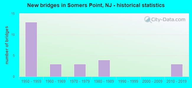
- New bridges - historical statistics
- 131950-1959
- 31960-1969
- 31970-1979
- 41980-1989
- 32010-2019

- Reconstructed bridges - Historical Statistics
- 12000-2009
- 22010-2019


- Bridge Condition - Deck
- 11.8%Very good
- 23.5%Good
- 58.8%Satisfactory
- 5.9%Fair

- Bridge Condition - Superstructure
- 17.6%Very good
- 23.5%Good
- 47.1%Satisfactory
- 11.8%Fair

- Bridge Condition - Substructure
- 47.1%Good
- 29.4%Satisfactory
- 23.5%Fair

- Bridge Condition - Channel
- 50.0%Very good
- 50.0%Good
Find on map >> Show street view
Structure Number: 122157, Location: 0.97 MI E OF CR 635 (Lat: 39.314089, Lng: -74.571331), Route carried "on" structure: State highway 152, Year Built: 1988, Status: Open, Structure Length: 1.28m (4.20ft), Average Daily Traffic: 11,880 (year 2021), Truck Traffic: 7%, Average Future Daily Traffic: 14,255 (year 2041), Design Load: HS 20+Mod, Features Intersected: CREEK AT STA 61+49
Minimum Vertical Clearance: 30+ m (98+ ft), Kilometerpoint: 1.561, Lanes on structure: 2, Base Highway Network: Yes, Owner: State Highway Agency, Approaching Roadway Width: 15.2m (49.9ft), Material/Design: Prestressed concrete, Design/Construction: Slab, Number Of Spans In Main Unit: 2, Length of Maximum Span: 5.8m (19.0ft), Curb or Sidewalk Widths: Left: 0.0m, Right: 1.8m (5.9ft), Curb-To-Curb Width: 15.2m (49.9ft), Out-to-Out Width: 17.9m (58.7ft)
Condition: Deck: Satisfactory, Superstructure: Very good, Substructure: Satisfactory, Channel: Very good, Operating Rating: 54.4 metric tons, Method Used To Determine Operating Rating: Field evaluation and documented engineering judgment, Inventory Rating: 32.7 metric tons, Method Used To Determine Inventory Rating: Field evaluation and documented engineering judgment, Structural Evaluation: Equal to present minimum criteria, Deck Geometry: Superior to present desirable criteria, Waterway Adequacy: Equal to present minimum criteria, Approach Roadway Alignment: Equal to present desirable criteria, Designated Inspection Frequency: Every 24 months, Inspection Date: March 2021, Deck Structure Type: Concrete Cast-file-Place, Wearing Surface/Protective System: Wearing Surface: Monolithic Concrete, Deck Protection: Epoxy Coated Reinforcing
Find on map >> Show street view
Structure Number: 122158, Location: 0.13 M.E.OF BASS HARBOR (Lat: 39.315611, Lng: -74.583611), Route carried "on" structure: State highway 152, Year Built: 1988, Status: Open, Structure Length: 2.71m (8.89ft), Average Daily Traffic: 12,150 (year 2021), Truck Traffic: 7%, Average Future Daily Traffic: 14,580 (year 2041), Design Load: HS 20+Mod, Features Intersected: SOMERS CREEK
Minimum Vertical Clearance: 30+ m (98+ ft), Kilometerpoint: 0.483, Lanes on structure: 2, Base Highway Network: Yes, Owner: State Highway Agency, Approaching Roadway Width: 15.2m (49.9ft), Material/Design: Prestressed concrete, Design/Construction: Slab, Number Of Spans In Main Unit: 3, Length of Maximum Span: 8.8m (28.9ft), Curb or Sidewalk Widths: Left: 0.0m, Right: 1.8m (5.9ft), Curb-To-Curb Width: 15.2m (49.9ft), Out-to-Out Width: 18.0m (59.1ft)
Condition: Deck: Satisfactory, Superstructure: Good, Substructure: Fair, Channel: Very good, Operating Rating: 54.4 metric tons, Method Used To Determine Operating Rating: Field evaluation and documented engineering judgment, Inventory Rating: 32.7 metric tons, Method Used To Determine Inventory Rating: Field evaluation and documented engineering judgment, Structural Evaluation: Somewhat better than minimum adequacy, Deck Geometry: Superior to present desirable criteria, Waterway Adequacy: Equal to present minimum criteria, Approach Roadway Alignment: Equal to present desirable criteria, Designated Inspection Frequency: Every 24 months, Inspection Date: April 2021, Deck Structure Type: Concrete Cast-file-Place, Wearing Surface/Protective System: Wearing Surface: Latex Concrete, Deck Protection: Epoxy Coated Reinforcing
Find on map >> Show street view
Structure Number: 122159, Location: 1.46 MI W OF BROAD THORO- (Lat: 39.316719, Lng: -74.585889), Route carried "on" structure: State highway 152, Year Built: 1988, Status: Open, Structure Length: 7.22m (23.69ft), Average Daily Traffic: 12,150 (year 2021), Truck Traffic: 4%, Average Future Daily Traffic: 14,580 (year 2041), Design Load: HS 20+Mod, Features Intersected: BASS HARBOR
Minimum Vertical Clearance: 30+ m (98+ ft), Kilometerpoint: 0.274, Lanes on structure: 2, Base Highway Network: Yes, Owner: State Highway Agency, Approaching Roadway Width: 15.2m (49.9ft), Material/Design: Prestressed concrete, Design/Construction: Slab, Number Of Spans In Main Unit: 7, Length of Maximum Span: 11.3m (37.1ft), Curb or Sidewalk Widths: Left: 0.0m, Right: 1.8m (5.9ft), Curb-To-Curb Width: 15.2m (49.9ft), Out-to-Out Width: 18.0m (59.1ft)
Condition: Deck: Satisfactory, Superstructure: Satisfactory, Substructure: Satisfactory, Channel: Very good, Operating Rating: 54.4 metric tons, Method Used To Determine Operating Rating: Field evaluation and documented engineering judgment, Inventory Rating: 32.7 metric tons, Method Used To Determine Inventory Rating: Field evaluation and documented engineering judgment, Structural Evaluation: Equal to present minimum criteria, Deck Geometry: Superior to present desirable criteria, Waterway Adequacy: Equal to present desirable criteria, Approach Roadway Alignment: Equal to present desirable criteria, Designated Inspection Frequency: Every 24 months, Underwater Inspection Frequency: Every 48 months, Inspection Date: April 2021, Underwater Inspection Date: April 2021, Deck Structure Type: Concrete Cast-file-Place, Wearing Surface/Protective System: Wearing Surface: Latex Concrete, Deck Protection: Epoxy Coated Reinforcing
Find on map >> Show street view
Structure Number: 1EH032, Location: .85 MI WEST RT-9 (NEW RD) (Lat: 39.315361, Lng: -74.627731), Route carried "on" structure: County highway 559, Year Built: 1967, Status: Posted for load, Structure Length: 20.82m (68.31ft), Average Daily Traffic: 7,289 (year 2021), Truck Traffic: 4%, Average Future Daily Traffic: 8,747 (year 2041), Design Load: HS 20, Features Intersected: PATCONG CREEK, Facility Carried by Structure: MAYS LNDG-SMRS PT
Minimum Vertical Clearance: 30+ m (98+ ft), Kilometerpoint: 2.639, Lanes on structure: 2, Owner: County Highway Agency, Approaching Roadway Width: 8.5m (27.9ft), Navigation Control: Yes ( Vertical Clearance: 4.6m (15.1ft), Horizontal Clearance: 21.3m (69.9ft)), Material/Design: Prestressed concrete, Design/Construction: Tee Beam, Number Of Spans In Main Unit: 1, Number Of Approach Spans: 15, Length of Maximum Span: 23.8m (78.1ft), Curb or Sidewalk Widths: Left: 0.6m (2.0ft), Right: 0.3m (1.0ft), Curb-To-Curb Width: 8.5m (27.9ft), Out-to-Out Width: 10.1m (33.1ft)
Condition: Deck: Good, Superstructure: Satisfactory, Substructure: Fair, Channel: Good, Operating Rating: 63.5 metric tons, Method Used To Determine Operating Rating: Load Factor (LF), Inventory Rating: 38.1 metric tons, Method Used To Determine Inventory Rating: Load Factor (LF), Structural Evaluation: Somewhat better than minimum adequacy, Deck Geometry: Meets minimum limits, Waterway Adequacy: Equal to present desirable criteria, Approach Roadway Alignment: Equal to present desirable criteria, Length Of Structure Improvement: 9999.99m (32808.37ft), Designated Inspection Frequency: Every 24 months, Underwater Inspection Frequency: Every 48 months, Inspection Date: January 2021, Underwater Inspection Date: April 2021, Bridge Improvement Cost: $11,044,000, Roadway Improvement Cost: $154,000, Total Project Cost: $15,677,000 ( Estimate for 2015), Deck Structure Type: Concrete Cast-file-Place, Wearing Surface/Protective System: Wearing Surface: Monolithic Concrete
Find on map >> Show street view
Structure Number: 1SP001, Location: .08 MI E OF BAY AVENUE (Lat: 39.313981, Lng: -74.589150), Route carried "on" structure: City street , Year Built: 1987, Status: Open, Structure Length: 1.37m (4.49ft), Average Daily Traffic: 121 (year 2021), Truck Traffic: 1%, Average Future Daily Traffic: 146 (year 2041), Features Intersected: LANDING CREEK, Facility Carried by Structure: HARBOR LANE
Minimum Vertical Clearance: 30+ m (98+ ft), Kilometerpoint: 0.000, Lanes on structure: 2, Owner: Private, Approaching Roadway Width: 6.7m (22.0ft), Material/Design: Wood or Timber, Design/Construction: Stringer/Multi-beam, Number Of Spans In Main Unit: 3, Length of Maximum Span: 4.3m (14.1ft), Curb or Sidewalk Widths: Left: 0.0m, Right: 1.4m (4.6ft), Curb-To-Curb Width: 6.8m (22.3ft), Out-to-Out Width: 9.3m (30.5ft)
Condition: Deck: Satisfactory, Superstructure: Good, Substructure: Fair, Channel: Very good, Operating Rating: 78.0 metric tons, Method Used To Determine Operating Rating: Allowable Stress (AS), Inventory Rating: 58.1 metric tons, Method Used To Determine Inventory Rating: Allowable Stress (AS), Structural Evaluation: Somewhat better than minimum adequacy, Deck Geometry: Meets minimum limits, Waterway Adequacy: Equal to present desirable criteria, Approach Roadway Alignment: Equal to present desirable criteria, Designated Inspection Frequency: Every 24 months, Inspection Date: Febuary 2021, Deck Structure Type: Wood or Timber
Find on map >> Show street view
Structure Number: 360280N, Location: 0.8 MI S GREAT EGG TOLL (Lat: 39.296667, Lng: -74.621667), Route carried "on" structure: Other road GSP, Year Built: 1973, Year Reconstructed: 2018, Status: Open, Structure Length: 111.83m (366.90ft), Average Daily Traffic: 20,500 (year 2020), Truck Traffic: 3%, Average Future Daily Traffic: 25,014 (year 2040), Design Load: HL 93, Features Intersected: GREAT EGG HARBOR&HRBR RD, Facility Carried by Structure: GARDEN ST PKWY NB
Minimum Vertical Clearance: 30+ m (98+ ft), Kilometerpoint: 44.144, Lanes on structure: 2, Lanes under structure: 1, Base Highway Network: Yes, Toll: On toll road, Owner: State Toll Authority, Approaching Roadway Width: 11.9m (39.0ft), Navigation Control: Yes ( Vertical Clearance: 14.9m (48.9ft), Horizontal Clearance: 44.2m (145.0ft)), Material/Design: Steel, Design/Construction: Stringer/Multi-beam, Number Of Spans In Main Unit: 11, Number Of Approach Spans: 36, Length of Maximum Span: 54.9m (180.1ft), Curb-To-Curb Width: 8.8m (28.9ft), Out-to-Out Width: 10.1m (33.1ft)
Condition: Deck: Very good, Superstructure: Very good, Substructure: Satisfactory, Channel: Good, Operating Rating: 68.4 metric tons, Method Used To Determine Operating Rating: Load and Resistance Factor Rating (LRFR) rating reported by rating factor(RF) method using HL-93 loadings, Inventory Rating: 52.8 metric tons, Method Used To Determine Inventory Rating: Load and Resistance Factor Rating (LRFR) rating reported by rating factor(RF) method using HL-93 loadings, Structural Evaluation: Equal to present minimum criteria, Deck Geometry: Meets minimum limits, Underclear: High priority of corrective action, Waterway Adequacy: Equal to present desirable criteria, Approach Roadway Alignment: Equal to present desirable criteria, Length Of Structure Improvement: 34.08m (111.81ft), Designated Inspection Frequency: Every 24 months, Underwater Inspection Frequency: Every 48 months, Inspection Date: October 2020, Underwater Inspection Date: December 2018, Bridge Improvement Cost: $1,807,000, Roadway Improvement Cost: $800,000, Total Project Cost: $2,262,000 ( Estimate for 2015), Deck Structure Type: Concrete Cast-file-Place, Wearing Surface/Protective System: Deck Protection: Epoxy Coated Reinforcing
Find on map >> Show street view
Structure Number: 360285N, Location: 0.3 MI S GREAT EGG TOLL (Lat: 39.296667, Lng: -74.621667), Route carried "on" structure: Other road GSP, Year Built: 1973, Year Reconstructed: 2018, Status: Open, Structure Length: 23.35m (76.61ft), Average Daily Traffic: 20,500 (year 2020), Truck Traffic: 3%, Average Future Daily Traffic: 25,014 (year 2040), Design Load: HL 93, Features Intersected: DRAG CHANNEL, Facility Carried by Structure: GARDEN ST PKWY NB
Minimum Vertical Clearance: 30+ m (98+ ft), Kilometerpoint: 45.834, Lanes on structure: 2, Base Highway Network: Yes, Toll: On toll road, Owner: State Toll Authority, Approaching Roadway Width: 10.1m (33.1ft), Material/Design: Steel, Design/Construction: Stringer/Multi-beam, Number Of Spans In Main Unit: 19, Length of Maximum Span: 12.2m (40.0ft), Curb-To-Curb Width: 8.8m (28.9ft), Out-to-Out Width: 10.1m (33.1ft)
Condition: Deck: Very good, Superstructure: Very good, Substructure: Satisfactory, Channel: Good, Operating Rating: 96.9 metric tons, Method Used To Determine Operating Rating: Load and Resistance Factor Rating (LRFR) rating reported by rating factor(RF) method using HL-93 loadings, Inventory Rating: 74.8 metric tons, Method Used To Determine Inventory Rating: Load and Resistance Factor Rating (LRFR) rating reported by rating factor(RF) method using HL-93 loadings, Structural Evaluation: Equal to present minimum criteria, Deck Geometry: Meets minimum limits, Waterway Adequacy: Superior to present desirable criteria, Approach Roadway Alignment: Equal to present desirable criteria, Designated Inspection Frequency: Every 24 months, Underwater Inspection Frequency: Every 48 months, Inspection Date: October 2020, Underwater Inspection Date: December 2018, Deck Structure Type: Concrete Cast-file-Place, Wearing Surface/Protective System: Deck Protection: Epoxy Coated Reinforcing
Find on map >> Show street view
Structure Number: 360289T, Location: 1.2 MI N-C.MAY-ATL CO LIN (Lat: 39.307753, Lng: -74.618817), Route carried "on" structure: US 9, Year Built: 1964, Status: Open, Structure Length: 12.07m (39.60ft), Average Daily Traffic: 11,937 (year 2021), Truck Traffic: 4%, Average Future Daily Traffic: 14,324 (year 2041), Design Load: HS 20, Features Intersected: GSP
Minimum Vertical Clearance: 30+ m (98+ ft), Kilometerpoint: 51.853, Lanes on structure: 2, Lanes under structure: 4, Base Highway Network: Yes, Owner: State Toll Authority, Approaching Roadway Width: 12.2m (40.0ft), Skew: 4 degrees, Material/Design: Steel, Design/Construction: Stringer/Multi-beam, Number Of Spans In Main Unit: 4, Length of Maximum Span: 44.8m (147.0ft), Curb or Sidewalk Widths: Left: 0.0m, Right: 1.5m (4.9ft), Curb-To-Curb Width: 12.6m (41.3ft), Out-to-Out Width: 14.9m (48.9ft)
Condition: Deck: Satisfactory, Superstructure: Fair, Substructure: Good, Operating Rating: 52.6 metric tons, Method Used To Determine Operating Rating: Load Factor (LF), Inventory Rating: 31.8 metric tons, Method Used To Determine Inventory Rating: Load Factor (LF), Structural Evaluation: Somewhat better than minimum adequacy, Deck Geometry: Somewhat better than minimum adequacy, Underclear: High priority of corrective action, Approach Roadway Alignment: Equal to present desirable criteria, Designated Inspection Frequency: Every 24 months, Inspection Date: March 2021, Deck Structure Type: Concrete Cast-file-Place, Wearing Surface/Protective System: Wearing Surface: Bituminous, Membrane: Preformed Fabric, Deck Protection: Epoxy Coated Reinforcing
Find on map >> Show street view
Structure Number: 360293N, Location: .87 MI-GSP&US 9 INTRCHNG. (Lat: 39.314186, Lng: -74.620431), Route carried "on" structure: Other road GSP, Year Built: 1953, Status: Open, Structure Length: 2.16m (7.09ft), Average Daily Traffic: 15,530 (year 2021), Truck Traffic: 3%, Average Future Daily Traffic: 18,950 (year 2041), Design Load: HS 20, Features Intersected: MAYS LANDING RD (CR 559)
Minimum Vertical Clearance: 30+ m (98+ ft), Kilometerpoint: 47.154, Lanes on structure: 2, Lanes under structure: 2, Base Highway Network: Yes, Toll: On toll road, Owner: State Toll Authority, Approaching Roadway Width: 12.2m (40.0ft), Skew: 2 degrees, Material/Design: Steel, Design/Construction: Stringer/Multi-beam, Number Of Spans In Main Unit: 1, Length of Maximum Span: 19.5m (64.0ft), Curb-To-Curb Width: 12.4m (40.7ft), Out-to-Out Width: 13.5m (44.3ft)
Condition: Deck: Satisfactory, Superstructure: Satisfactory, Substructure: Good, Operating Rating: 41.5 metric tons, Method Used To Determine Operating Rating: Load and Resistance Factor Rating (LRFR) rating reported by rating factor(RF) method using HL-93 loadings, Inventory Rating: 31.8 metric tons, Method Used To Determine Inventory Rating: Load and Resistance Factor Rating (LRFR) rating reported by rating factor(RF) method using HL-93 loadings, Structural Evaluation: Equal to present minimum criteria, Deck Geometry: Better than present minimum criteria, Underclear: Equal to present minimum criteria, Approach Roadway Alignment: Equal to present desirable criteria, Designated Inspection Frequency: Every 24 months, Inspection Date: March 2021, Deck Structure Type: Concrete Cast-file-Place, Wearing Surface/Protective System: Wearing Surface: Bituminous, Membrane: Preformed Fabric
Find on map >> Show street view
Structure Number: 360294S, Location: .87MI N-GSP& US9 INTERCH (Lat: 39.314336, Lng: -74.621019), Route carried "on" structure: Other road GSP, Year Built: 1953, Status: Open, Structure Length: 2.16m (7.09ft), Average Daily Traffic: 15,550 (year 2021), Truck Traffic: 3%, Average Future Daily Traffic: 18,970 (year 2041), Design Load: HS 20, Features Intersected: MAYS LANDING RD (CR 559)
Minimum Vertical Clearance: 30+ m (98+ ft), Kilometerpoint: 47.154, Lanes on structure: 2, Lanes under structure: 2, Base Highway Network: Yes, Toll: On toll road, Owner: State Toll Authority, Approaching Roadway Width: 12.2m (40.0ft), Skew: 2 degrees, Material/Design: Steel, Design/Construction: Stringer/Multi-beam, Number Of Spans In Main Unit: 1, Length of Maximum Span: 19.5m (64.0ft), Curb-To-Curb Width: 12.4m (40.7ft), Out-to-Out Width: 13.5m (44.3ft)
Condition: Deck: Satisfactory, Superstructure: Satisfactory, Substructure: Good, Operating Rating: 44.4 metric tons, Method Used To Determine Operating Rating: Load and Resistance Factor Rating (LRFR) rating reported by rating factor(RF) method using HL-93 loadings, Inventory Rating: 34.3 metric tons, Method Used To Determine Inventory Rating: Load and Resistance Factor Rating (LRFR) rating reported by rating factor(RF) method using HL-93 loadings, Structural Evaluation: Equal to present minimum criteria, Deck Geometry: Better than present minimum criteria, Underclear: Equal to present minimum criteria, Approach Roadway Alignment: Equal to present desirable criteria, Designated Inspection Frequency: Every 24 months, Inspection Date: March 2021, Deck Structure Type: Concrete Cast-file-Place, Wearing Surface/Protective System: Wearing Surface: Bituminous, Membrane: Preformed Fabric
Find on map >> Show street view
Structure Number: 360300N, Location: 1 MI N OF GSP & US 9 JCT (Lat: 39.323503, Lng: -74.617197), Route carried "on" structure: Ramp Other road GSP, Year Built: 1954, Status: Open, Structure Length: 1.37m (4.49ft), Average Daily Traffic: 5,960 (year 2021), Truck Traffic: 3%, Average Future Daily Traffic: 8,120 (year 2041), Design Load: H 20, Features Intersected: GSP NB, Facility Carried by Structure: EXIT RAMP TO NJ 52
Minimum Vertical Clearance: 30+ m (98+ ft), Kilometerpoint: 48.280, Lanes on structure: 2, Lanes under structure: 2, Toll: On toll road, Owner: State Toll Authority, Approaching Roadway Width: 11.6m (38.1ft), Material/Design: Concrete, Design/Construction: Tee Beam, Number Of Spans In Main Unit: 1, Length of Maximum Span: 13.1m (43.0ft), Curb-To-Curb Width: 12.8m (42.0ft), Out-to-Out Width: 14.0m (45.9ft)
Condition: Deck: Fair, Superstructure: Fair, Substructure: Good, Operating Rating: 33.0 metric tons, Method Used To Determine Operating Rating: Load and Resistance Factor Rating (LRFR) rating reported by rating factor(RF) method using HL-93 loadings, Inventory Rating: 23.3 metric tons, Method Used To Determine Inventory Rating: Load and Resistance Factor Rating (LRFR) rating reported by rating factor(RF) method using HL-93 loadings, Structural Evaluation: Somewhat better than minimum adequacy, Deck Geometry: Superior to present desirable criteria, Underclear: High priority of corrective action, Approach Roadway Alignment: Equal to present desirable criteria, Designated Inspection Frequency: Every 24 months, Inspection Date: April 2021, Deck Structure Type: Concrete Cast-file-Place, Wearing Surface/Protective System: Wearing Surface: Bituminous
Find on map >> Show street view
Structure Number: 360300S, Location: 1 MI N OF GSP & US 9 JCT (Lat: 39.323794, Lng: -74.617631), Route carried "on" structure: Ramp Other road GSP, Year Built: 1954, Status: Open, Structure Length: 1.37m (4.49ft), Average Daily Traffic: 5,960 (year 2021), Truck Traffic: 3%, Average Future Daily Traffic: 8,120 (year 2041), Design Load: H 20, Features Intersected: GSP SB, Facility Carried by Structure: EXIT RAMP TO NJ 52
Minimum Vertical Clearance: 30+ m (98+ ft), Kilometerpoint: 48.280, Lanes on structure: 2, Lanes under structure: 2, Toll: On toll road, Owner: State Toll Authority, Approaching Roadway Width: 11.6m (38.1ft), Material/Design: Concrete, Design/Construction: Tee Beam, Number Of Spans In Main Unit: 1, Length of Maximum Span: 13.1m (43.0ft), Curb-To-Curb Width: 12.8m (42.0ft), Out-to-Out Width: 14.0m (45.9ft)
Condition: Deck: Satisfactory, Superstructure: Satisfactory, Substructure: Good, Operating Rating: 25.3 metric tons, Method Used To Determine Operating Rating: Load and Resistance Factor Rating (LRFR) rating reported by rating factor(RF) method using HL-93 loadings, Inventory Rating: 17.5 metric tons, Method Used To Determine Inventory Rating: Load and Resistance Factor Rating (LRFR) rating reported by rating factor(RF) method using HL-93 loadings, Structural Evaluation: Meets minimum limits, Deck Geometry: Superior to present desirable criteria, Underclear: High priority of replacement, Approach Roadway Alignment: Equal to present desirable criteria, Designated Inspection Frequency: Every 24 months, Inspection Date: April 2021, Deck Structure Type: Concrete Cast-file-Place, Wearing Surface/Protective System: Wearing Surface: Bituminous
Find on map >> Show street view
Structure Number: 360310T, Location: 2.2 MI NO GREAT EGG TOLL (Lat: 39.335000, Lng: -74.607347), Route carried "on" structure: Other road GSP, Year Built: 1954, Year Reconstructed: 2013, Status: Open, Structure Length: 9.60m (31.50ft), Average Daily Traffic: 46,036 (year 2021), Truck Traffic: 3%, Average Future Daily Traffic: 55,243 (year 2041), Design Load: HL 93, Features Intersected: PATCONG CREEK, Facility Carried by Structure: GARDEN STATE PKWY
Minimum Vertical Clearance: 30+ m (98+ ft), Kilometerpoint: 49.890, Lanes on structure: 4, Base Highway Network: Yes, Toll: On toll road, Owner: State Toll Authority, Approaching Roadway Width: 36.6m (120.1ft), Skew: 30 degrees, Material/Design: Steel continuous, Design/Construction: Stringer/Multi-beam, Number Of Spans In Main Unit: 3, Number Of Approach Spans: 2, Length of Maximum Span: 27.4m (89.9ft), Curb-To-Curb Width: 36.6m (120.1ft), Out-to-Out Width: 38.6m (126.6ft)
Condition: Deck: Good, Superstructure: Good, Substructure: Fair, Channel: Very good, Operating Rating: 56.4 metric tons, Method Used To Determine Operating Rating: Load and Resistance Factor Rating (LRFR) rating reported by rating factor(RF) method using HL-93 loadings, Inventory Rating: 43.4 metric tons, Method Used To Determine Inventory Rating: Load and Resistance Factor Rating (LRFR) rating reported by rating factor(RF) method using HL-93 loadings, Structural Evaluation: Somewhat better than minimum adequacy, Deck Geometry: Superior to present desirable criteria, Waterway Adequacy: Equal to present desirable criteria, Approach Roadway Alignment: Equal to present desirable criteria, Designated Inspection Frequency: Every 24 months, Underwater Inspection Frequency: Every 48 months, Inspection Date: April 2021, Underwater Inspection Date: April 2021, Deck Structure Type: Concrete Cast-file-Place, Wearing Surface/Protective System: Wearing Surface: Monolithic Concrete, Deck Protection: Other Coated Reinforcing
Find on map >> Show street view
Structure Number: 360316N, Location: 4 MI N OF RTS 9 & 52 JCT (Lat: 39.342678, Lng: -74.602206), Route carried "on" structure: Other road GSP, Year Built: 1954, Status: Open, Structure Length: 1.89m (6.20ft), Average Daily Traffic: 21,490 (year 2021), Truck Traffic: 3%, Average Future Daily Traffic: 26,220 (year 2041), Design Load: HS 20, Features Intersected: OCEAN HTS AVE (CR 559A)
Minimum Vertical Clearance: 30+ m (98+ ft), Kilometerpoint: 50.823, Lanes on structure: 2, Lanes under structure: 2, Base Highway Network: Yes, Toll: On toll road, Owner: State Toll Authority, Approaching Roadway Width: 12.2m (40.0ft), Skew: 2 degrees, Material/Design: Prestressed concrete, Design/Construction: Stringer/Multi-beam, Number Of Spans In Main Unit: 1, Length of Maximum Span: 18.3m (60.0ft), Curb-To-Curb Width: 12.4m (40.7ft), Out-to-Out Width: 13.4m (44.0ft)
Condition: Deck: Satisfactory, Superstructure: Satisfactory, Substructure: Satisfactory, Operating Rating: 21.1 metric tons, Method Used To Determine Operating Rating: Load and Resistance Factor Rating (LRFR) rating reported by rating factor(RF) method using HL-93 loadings, Inventory Rating: 9.1 metric tons, Method Used To Determine Inventory Rating: Load and Resistance Factor Rating (LRFR) rating reported by rating factor(RF) method using HL-93 loadings, Structural Evaluation: High priority of replacement, Deck Geometry: Better than present minimum criteria, Underclear: Equal to present minimum criteria, Approach Roadway Alignment: Equal to present desirable criteria, Length Of Structure Improvement: 1.89m (6.20ft), Designated Inspection Frequency: Every 24 months, Inspection Date: March 2021, Bridge Improvement Cost: $1,732,000, Roadway Improvement Cost: $174,000, Total Project Cost: $1,906,000 ( Estimate for 2019), Deck Structure Type: Concrete Cast-file-Place, Wearing Surface/Protective System: Wearing Surface: Bituminous, Membrane: Preformed Fabric
Find on map >> Show street view
Structure Number: 360316S, Location: 4 MI N OF RTS 9 & 52 JCT (Lat: 39.343072, Lng: -74.602553), Route carried "on" structure: Other road GSP, Year Built: 1953, Status: Open, Structure Length: 1.92m (6.30ft), Average Daily Traffic: 21,450 (year 2021), Truck Traffic: 3%, Average Future Daily Traffic: 26,170 (year 2041), Design Load: HS 20, Features Intersected: OCEAN HTS AVE (CR 559A)
Minimum Vertical Clearance: 30+ m (98+ ft), Kilometerpoint: 50.823, Lanes on structure: 2, Lanes under structure: 2, Base Highway Network: Yes, Toll: On toll road, Owner: State Toll Authority, Approaching Roadway Width: 12.5m (41.0ft), Skew: 2 degrees, Material/Design: Prestressed concrete, Design/Construction: Stringer/Multi-beam, Number Of Spans In Main Unit: 1, Length of Maximum Span: 18.3m (60.0ft), Curb-To-Curb Width: 12.4m (40.7ft), Out-to-Out Width: 13.4m (44.0ft)
Condition: Deck: Satisfactory, Superstructure: Good, Substructure: Good, Operating Rating: 22.0 metric tons, Method Used To Determine Operating Rating: Load and Resistance Factor Rating (LRFR) rating reported by rating factor(RF) method using HL-93 loadings, Inventory Rating: 9.7 metric tons, Method Used To Determine Inventory Rating: Load and Resistance Factor Rating (LRFR) rating reported by rating factor(RF) method using HL-93 loadings, Structural Evaluation: High priority of replacement, Deck Geometry: Better than present minimum criteria, Underclear: Meets minimum limits, Approach Roadway Alignment: Equal to present desirable criteria, Length Of Structure Improvement: 1.92m (6.30ft), Designated Inspection Frequency: Every 24 months, Inspection Date: March 2021, Bridge Improvement Cost: $1,732,000, Roadway Improvement Cost: $174,000, Total Project Cost: $1,906,000 ( Estimate for 2019), Deck Structure Type: Concrete Cast-file-Place, Wearing Surface/Protective System: Wearing Surface: Bituminous, Membrane: Other
Find on map >> Show street view
Structure Number: 370280S, Location: .8 MI S. GREAT EGG TOLL (Lat: 39.297811, Lng: -74.620800), Route carried "on" structure: Other road GSP, Year Built: 2016, Status: Open, Structure Length: 117.04m (383.99ft), Average Daily Traffic: 19,620 (year 2020), Truck Traffic: 3%, Average Future Daily Traffic: 23,940 (year 2040), Design Load: HL 93, Features Intersected: GREAT EGG HARBOR&HRBR RD, Facility Carried by Structure: PARKWAY S
Minimum Vertical Clearance: 30+ m (98+ ft), Kilometerpoint: 44.144, Lanes on structure: 2, Lanes under structure: 2, Base Highway Network: Yes, Toll: On toll road, Owner: State Toll Authority, Approaching Roadway Width: 16.8m (55.1ft), Navigation Control: Yes ( Vertical Clearance: 16.8m (55.1ft), Horizontal Clearance: 45.1m (148.0ft)), Material/Design: Prestressed concrete continuous, Design/Construction: Stringer/Multi-beam, Number Of Spans In Main Unit: 4, Number Of Approach Spans: 20, Length of Maximum Span: 76.2m (250.0ft), Curb or Sidewalk Widths: Left: 0.0m, Right: 3.0m (9.8ft), Curb-To-Curb Width: 16.8m (55.1ft), Out-to-Out Width: 21.3m (69.9ft)
Condition: Deck: Good, Superstructure: Satisfactory, Substructure: Good, Channel: Good, Operating Rating: 45.0 metric tons, Method Used To Determine Operating Rating: Load and Resistance Factor Rating (LRFR) rating reported by rating factor(RF) method using HL-93 loadings, Inventory Rating: 31.1 metric tons, Method Used To Determine Inventory Rating: Load and Resistance Factor Rating (LRFR) rating reported by rating factor(RF) method using HL-93 loadings, Structural Evaluation: Equal to present minimum criteria, Deck Geometry: Superior to present desirable criteria, Underclear: Meets minimum limits, Waterway Adequacy: Equal to present desirable criteria, Approach Roadway Alignment: Equal to present desirable criteria, Designated Inspection Frequency: Every 24 months, Underwater Inspection Frequency: Every 48 months, Inspection Date: September 2020, Underwater Inspection Date: September 2020, Deck Structure Type: Concrete Cast-file-Place, Wearing Surface/Protective System: Wearing Surface: Monolithic Concrete, Deck Protection: Epoxy Coated Reinforcing
Find on map >> Show street view
Structure Number: 370285S, Location: 0.3 MI S GREAT EGG TOLL (Lat: 39.303567, Lng: -74.618600), Route carried "on" structure: Other road GSP, Year Built: 2016, Status: Open, Structure Length: 23.56m (77.30ft), Average Daily Traffic: 19,620 (year 2020), Truck Traffic: 3%, Average Future Daily Traffic: 23,940 (year 2040), Design Load: HL 93, Features Intersected: DRAG CHANNEL, Facility Carried by Structure: GARDEN ST PKWY SB
Minimum Vertical Clearance: 30+ m (98+ ft), Kilometerpoint: 45.834, Lanes on structure: 2, Base Highway Network: Yes, Toll: On toll road, Owner: State Toll Authority, Approaching Roadway Width: 16.8m (55.1ft), Material/Design: Prestressed concrete continuous, Design/Construction: Stringer/Multi-beam, Number Of Spans In Main Unit: 10, Length of Maximum Span: 24.7m (81.0ft), Curb or Sidewalk Widths: Left: 0.0m, Right: 3.0m (9.8ft), Curb-To-Curb Width: 16.8m (55.1ft), Out-to-Out Width: 21.3m (69.9ft)
Condition: Deck: Good, Superstructure: Satisfactory, Substructure: Good, Channel: Good, Operating Rating: 46.0 metric tons, Method Used To Determine Operating Rating: Load and Resistance Factor Rating (LRFR) rating reported by rating factor(RF) method using HL-93 loadings, Inventory Rating: 35.6 metric tons, Method Used To Determine Inventory Rating: Load and Resistance Factor Rating (LRFR) rating reported by rating factor(RF) method using HL-93 loadings, Structural Evaluation: Equal to present minimum criteria, Deck Geometry: Superior to present desirable criteria, Waterway Adequacy: Better than present minimum criteria, Approach Roadway Alignment: Equal to present desirable criteria, Designated Inspection Frequency: Every 24 months, Underwater Inspection Frequency: Every 48 months, Inspection Date: September 2020, Underwater Inspection Date: September 2020, Deck Structure Type: Concrete Cast-file-Place, Wearing Surface/Protective System: Wearing Surface: Monolithic Concrete, Deck Protection: Epoxy Coated Reinforcing
Find on map >> Show street view
Structure Number: 360280N, Location: 0.8 MI S GREAT EGG TOLL (Lat: 39.296667, Lng: -74.621667), Route carried "under" structure: City street , Year Built: 1973, Structure Length: 0. m, Average Daily Traffic: 220 (year 2020), Truck Traffic: 1%, Features Intersected: GREAT EGG HARBOR&HRBR RD, Facility Carried by Structure: GARDEN ST PKWY NB
Minimum Vertical Clearance: 3.02m (9.91ft), Kilometerpoint: 0.000, Lanes on structure: 2, Lanes under structure: 1, Material/Design: Steel, Design/Construction: Stringer/Multi-beam, Length of Maximum Span: 54.9m (180.1ft)
Find on map >> Show street view
Structure Number: 360289T, Location: 1.2 MI N-C.MAY-ATL CO LIN (Lat: 39.307753, Lng: -74.618817), Route carried "under" structure: Other road GSP, Year Built: 1964, Structure Length: 0. m, Average Daily Traffic: 30,380 (year 2021), Truck Traffic: 3%, Features Intersected: GSP, Facility Carried by Structure: US 9 (NEW RD)
Minimum Vertical Clearance: 4.72m (15.49ft), Kilometerpoint: 46.510, Lanes on structure: 2, Lanes under structure: 4, Toll: On toll road, Material/Design: Steel, Design/Construction: Stringer/Multi-beam, Length of Maximum Span: 44.8m (147.0ft)
Find on map >> Show street view
Structure Number: 360293N, Location: .87 MI-GSP&US 9 INTRCHNG. (Lat: 39.314186, Lng: -74.620431), Route carried "under" structure: County highway 559, Year Built: 1953, Structure Length: 0. m, Average Daily Traffic: 5,039 (year 2021), Truck Traffic: 1%, Features Intersected: MAYS LANDING RD (CR 559), Facility Carried by Structure: GSP NB
Minimum Vertical Clearance: 4.60m (15.09ft), Kilometerpoint: 1.915, Lanes on structure: 2, Lanes under structure: 2, Material/Design: Steel, Design/Construction: Stringer/Multi-beam, Length of Maximum Span: 19.5m (64.0ft)
Find on map >> Show street view
Structure Number: 360294S, Location: .87MI N-GSP& US9 INTERCH (Lat: 39.314336, Lng: -74.621019), Route carried "under" structure: County highway 559, Year Built: 1953, Structure Length: 0. m, Average Daily Traffic: 5,039 (year 2021), Truck Traffic: 1%, Features Intersected: MAYS LANDING RD (CR 559), Facility Carried by Structure: GSP SB
Minimum Vertical Clearance: 4.82m (15.81ft), Kilometerpoint: 1.963, Lanes on structure: 2, Lanes under structure: 2, Material/Design: Steel, Design/Construction: Stringer/Multi-beam, Length of Maximum Span: 19.5m (64.0ft)
Find on map >> Show street view
Structure Number: 360300N, Location: 1 MI N OF GSP & US 9 JCT (Lat: 39.323503, Lng: -74.617197), Route carried "under" structure: Other road GSP, Year Built: 1954, Structure Length: 0. m, Average Daily Traffic: 15,843 (year 2021), Truck Traffic: 3%, Features Intersected: GSP NB, Facility Carried by Structure: EXIT RAMP TO NJ 52
Minimum Vertical Clearance: 4.24m (13.91ft), Kilometerpoint: 48.280, Lanes on structure: 2, Lanes under structure: 2, Toll: On toll road, Material/Design: Concrete, Design/Construction: Tee Beam, Length of Maximum Span: 13.1m (43.0ft)
Find on map >> Show street view
Structure Number: 360300S, Location: 1 MI N OF GSP & US 9 JCT (Lat: 39.323794, Lng: -74.617631), Route carried "under" structure: Other road GSP, Year Built: 1954, Structure Length: 0. m, Average Daily Traffic: 14,550 (year 2021), Truck Traffic: 3%, Features Intersected: GSP SB, Facility Carried by Structure: EXIT RAMP TO NJ 52
Minimum Vertical Clearance: 4.27m (14.01ft), Kilometerpoint: 48.280, Lanes on structure: 2, Lanes under structure: 2, Toll: On toll road, Material/Design: Concrete, Design/Construction: Tee Beam, Length of Maximum Span: 13.1m (43.0ft)
Find on map >> Show street view
Structure Number: 360316N, Location: 4 MI N OF RTS 9 & 52 JCT (Lat: 39.342678, Lng: -74.602206), Route carried "under" structure: Alternate County highway 559A, Year Built: 1954, Structure Length: 0. m, Average Daily Traffic: 9,057 (year 2021), Truck Traffic: 1%, Features Intersected: OCEAN HTS AVE (CR 559A), Facility Carried by Structure: GSP NB
Minimum Vertical Clearance: 4.93m (16.17ft), Kilometerpoint: 2.269, Lanes on structure: 2, Lanes under structure: 2, Material/Design: Prestressed concrete, Design/Construction: Stringer/Multi-beam, Length of Maximum Span: 18.3m (60.0ft)
Find on map >> Show street view
Structure Number: 360316S, Location: 4 MI N OF RTS 9 & 52 JCT (Lat: 39.343072, Lng: -74.602553), Route carried "under" structure: Alternate County highway 559A, Year Built: 1953, Structure Length: 0. m, Average Daily Traffic: 9,147 (year 2021), Truck Traffic: 2%, Features Intersected: OCEAN HTS AVE (CR 559A), Facility Carried by Structure: GSP SB
Minimum Vertical Clearance: 4.80m (15.75ft), Kilometerpoint: 2.301, Lanes on structure: 2, Lanes under structure: 2, Material/Design: Prestressed concrete, Design/Construction: Stringer/Multi-beam, Length of Maximum Span: 18.3m (60.0ft)
Find on map >> Show street view
Structure Number: 370280S, Location: .8 MI S. GREAT EGG TOLL (Lat: 39.297811, Lng: -74.620800), Route carried "under" structure: City street , Year Built: 2016, Structure Length: 0. m, Average Daily Traffic: 220 (year 2020), Truck Traffic: 1%, Features Intersected: GREAT EGG HARBOR&HRBR RD, Facility Carried by Structure: PARKWAY S
Minimum Vertical Clearance: 4.75m (15.58ft), Kilometerpoint: 0.000, Lanes on structure: 2, Lanes under structure: 2, Material/Design: Prestressed concrete continuous, Design/Construction: Stringer/Multi-beam, Length of Maximum Span: 76.2m (250.0ft)