Bridge Statistics for Socorro, New Mexico (NM)
Condition, Traffic, Stress, Structural Evaluation, Project Costs
- National Bridge Inventory (NBI) Statistics
- 34Number of bridges
- 410ft / 125mTotal length
- $7,884,000Total costs
- 170,170Total average daily traffic
- 63,039Total average daily truck traffic
- National Bridge Inventory (NBI) Registered Bridges for Socorro
- No street view available for this location
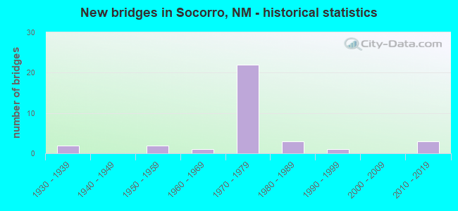
- New bridges - historical statistics
- 21930-1939
- 21950-1959
- 11960-1969
- 221970-1979
- 31980-1989
- 11990-1999
- 32010-2019


- Bridge Condition - Deck
- 61.9%Good
- 28.6%Satisfactory
- 9.5%Fair

- Bridge Condition - Superstructure
- 47.6%Good
- 28.6%Satisfactory
- 19.0%Fair
- 4.8%Serious

- Bridge Condition - Substructure
- 71.4%Good
- 19.0%Satisfactory
- 4.8%Fair
- 4.8%Poor

- Bridge Condition - Channel
- 15.4%Very good
- 23.1%Good
- 38.5%Satisfactory
- 7.7%Fair
- 15.4%Poor

- Bridge Condition - Culverts
- 25.0%Satisfactory
- 50.0%Fair
- 25.0%Poor
Find on map >> Show street view
Structure Number: 401-1283, Location: Soccoro at Otero Ave East (Lat: 34.061508, Lng: -106.876536), Route carried "on" structure: ServiceFederal lands road , Year Built: 1986, Status: Open, Structure Length: 2.51m (8.23ft), Average Daily Traffic: 30 (year 2008), Average Future Daily Traffic: 30 (year 2035), Design Load: HS 20, Features Intersected: Low Flow Cannal, Facility Carried by Structure: Gravel Road
Minimum Vertical Clearance: 30+ m (98+ ft), Kilometerpoint: 0.000, Lanes on structure: 2, Owner: Bureau of Reclamation, Approaching Roadway Width: 7.6m (24.9ft), Material/Design: Prestressed concrete, Design/Construction: Stringer/Multi-beam, Number Of Spans In Main Unit: 1, Length of Maximum Span: 24.4m (80.1ft), Curb-To-Curb Width: 6.1m (20.0ft), Out-to-Out Width: 6.4m (21.0ft)
Condition: Deck: Satisfactory, Superstructure: Good, Substructure: Good, Channel: Satisfactory, Operating Rating: 55.8 metric tons, Method Used To Determine Operating Rating: Load Factor (LF), Inventory Rating: 33.3 metric tons, Method Used To Determine Inventory Rating: Load Factor (LF), Structural Evaluation: Better than present minimum criteria, Deck Geometry: Somewhat better than minimum adequacy, Waterway Adequacy: Superior to present desirable criteria, Approach Roadway Alignment: High priority of corrective action, Designated Inspection Frequency: Every 24 months, Inspection Date: September 2020, Deck Structure Type: Concrete Cast-file-Place, Wearing Surface/Protective System: Wearing Surface: Gravel
Find on map >> Show street view
Structure Number: 3196, Location: 7.6 MI N OF JCT US-380 (Lat: 34.017728, Lng: -106.895406), Route carried "on" structure: State highway 1, Year Built: 1939, Status: Open, Structure Length: 0.98m (3.22ft), Average Daily Traffic: 1,232 (year 2020), Truck Traffic: 6%, Average Future Daily Traffic: 1,824 (year 2040), Design Load: H 15, Features Intersected: UNNAMED WATERWAY
Minimum Vertical Clearance: 30+ m (98+ ft), Kilometerpoint: 95.836, Lanes on structure: 2, Owner: State Highway Agency, Approaching Roadway Width: 6.9m (22.6ft), Material/Design: Concrete continuous, Design/Construction: Culvert, Number Of Spans In Main Unit: 5, Length of Maximum Span: 1.8m (5.9ft)
Condition: Channel: Fair, Culverts: Fair, Operating Rating: 40.8 metric tons, Method Used To Determine Operating Rating: Load Factor (LF), Inventory Rating: 24.5 metric tons, Method Used To Determine Inventory Rating: Load Factor (LF), Structural Evaluation: Somewhat better than minimum adequacy, Waterway Adequacy: Equal to present desirable criteria, Approach Roadway Alignment: Equal to present desirable criteria, Length Of Structure Improvement: 1.04m (3.41ft), Designated Inspection Frequency: Every 24 months, Inspection Date: April 2020, Bridge Improvement Cost: $12,000, Roadway Improvement Cost: $1,000, Total Project Cost: $14,000
Find on map >> Show street view
Structure Number: 5838, Location: 4.8 M N Jct NM-408/I-25 (Lat: 34.225611, Lng: -106.919278), Route carried "on" structure: Interstate 25, Year Built: 1958, Status: Open, Structure Length: 4.66m (15.29ft), Average Daily Traffic: 4,800 (year 2020), Truck Traffic: 37%, Average Future Daily Traffic: 8,217 (year 2040), Design Load: HS 20, Features Intersected: San Lorenzo Arroyo
Minimum Vertical Clearance: 30+ m (98+ ft), Kilometerpoint: 259.024, Lanes on structure: 2, Base Highway Network: Yes, Owner: State Highway Agency, Approaching Roadway Width: 11.9m (39.0ft), Material/Design: Concrete continuous, Design/Construction: Slab, Number Of Spans In Main Unit: 5, Length of Maximum Span: 10.1m (33.1ft), Curb-To-Curb Width: 11.9m (39.0ft), Out-to-Out Width: 12.7m (41.7ft)
Condition: Deck: Satisfactory, Superstructure: Satisfactory, Substructure: Good, Channel: Good, Operating Rating: 54.5 metric tons, Method Used To Determine Operating Rating: Load Factor (LF), Inventory Rating: 32.7 metric tons, Method Used To Determine Inventory Rating: Load Factor (LF), Structural Evaluation: Equal to present minimum criteria, Deck Geometry: Equal to present minimum criteria, Waterway Adequacy: Equal to present desirable criteria, Approach Roadway Alignment: Equal to present desirable criteria, Designated Inspection Frequency: Every 24 months, Inspection Date: July 2021, Deck Structure Type: Concrete Cast-file-Place, Wearing Surface/Protective System: Wearing Surface: Bituminous
Find on map >> Show street view
Structure Number: 6079, Location: 0.4 MI NW US-60/SOCORRO (Lat: 34.060828, Lng: -106.897489), Route carried "on" structure: County highway 53001, Year Built: 1958, Status: Open, Structure Length: 0.62m (2.03ft), Average Daily Traffic: 487 (year 2020), Truck Traffic: 6%, Average Future Daily Traffic: 793 (year 2040), Design Load: H 15, Features Intersected: UNNAMED WATERWAY, Facility Carried by Structure: 53-Z001
Minimum Vertical Clearance: 30+ m (98+ ft), Kilometerpoint: 0.013, Lanes on structure: 2, Owner: City or Municipal Highway Agency, Approaching Roadway Width: 12.5m (41.0ft), Material/Design: Concrete continuous, Design/Construction: Culvert, Number Of Spans In Main Unit: 2, Length of Maximum Span: 3.0m (9.8ft)
Condition: Channel: Poor, Culverts: Poor, Operating Rating: 58.8 metric tons, Method Used To Determine Operating Rating: Load Factor (LF), Inventory Rating: 32.7 metric tons, Method Used To Determine Inventory Rating: Load Factor (LF), Structural Evaluation: Meets minimum limits, Waterway Adequacy: Equal to present minimum criteria, Approach Roadway Alignment: Equal to present desirable criteria, Length Of Structure Improvement: 6.10m (20.01ft), Designated Inspection Frequency: Every 24 months, Inspection Date: May 2020, Bridge Improvement Cost: $200,000, Roadway Improvement Cost: $25,000, Total Project Cost: $300,000 ( Estimate for 2030)
Find on map >> Show street view
Structure Number: 6319, Location: 10.2 MI N OF US-380 (Lat: 34.063386, Lng: -106.892258), Route carried "on" structure: State highway 12, Year Built: 1939, Status: Open, Structure Length: 1.65m (5.41ft), Average Daily Traffic: 10,690 (year 2020), Truck Traffic: 7%, Average Future Daily Traffic: 15,043 (year 2040), Design Load: H 15, Features Intersected: SOCORRO CANYON
Minimum Vertical Clearance: 30+ m (98+ ft), Kilometerpoint: 2.800, Lanes on structure: 4, Base Highway Network: Yes, Owner: State Highway Agency, Approaching Roadway Width: 17.3m (56.8ft), Skew: 20 degrees, Material/Design: Concrete continuous, Design/Construction: Culvert, Number Of Spans In Main Unit: 5, Length of Maximum Span: 3.0m (9.8ft), Curb or Sidewalk Widths: Left: 2.1m (6.9ft), Right: 1.7m (5.6ft)
Condition: Channel: Satisfactory, Culverts: Fair, Operating Rating: 52.3 metric tons, Method Used To Determine Operating Rating: Load Factor (LF), Inventory Rating: 24.5 metric tons, Method Used To Determine Inventory Rating: Load Factor (LF), Structural Evaluation: Somewhat better than minimum adequacy, Waterway Adequacy: Equal to present desirable criteria, Approach Roadway Alignment: Equal to present desirable criteria, Designated Inspection Frequency: Every 24 months, Inspection Date: November 2020
Find on map >> Show street view
Structure Number: 6358, Location: 7.2 Mi W Jct US-60/I-25 (Lat: 34.006164, Lng: -106.987556), Route carried "on" structure: US 60, Year Built: 1962, Status: Open, Structure Length: 4.82m (15.81ft), Average Daily Traffic: 3,937 (year 2020), Truck Traffic: 16%, Average Future Daily Traffic: 3,038 (year 2040), Design Load: HS 20, Features Intersected: Bear Canyon
Minimum Vertical Clearance: 30+ m (98+ ft), Kilometerpoint: 212.353, Lanes on structure: 2, Base Highway Network: Yes, Owner: State Highway Agency, Approaching Roadway Width: 8.9m (29.2ft), Skew: 3 degrees, Material/Design: Steel continuous, Design/Construction: Stringer/Multi-beam, Number Of Spans In Main Unit: 3, Length of Maximum Span: 18.3m (60.0ft), Curb-To-Curb Width: 8.6m (28.2ft), Out-to-Out Width: 9.4m (30.8ft)
Condition: Deck: Satisfactory, Superstructure: Fair, Substructure: Satisfactory, Channel: Good, Operating Rating: 59.7 metric tons, Method Used To Determine Operating Rating: Load Factor (LF), Inventory Rating: 35.7 metric tons, Method Used To Determine Inventory Rating: Load Factor (LF), Structural Evaluation: Somewhat better than minimum adequacy, Deck Geometry: Meets minimum limits, Waterway Adequacy: Equal to present minimum criteria, Approach Roadway Alignment: Equal to present desirable criteria, Length Of Structure Improvement: 4.82m (15.81ft), Designated Inspection Frequency: Every 24 months, Inspection Date: Febuary 2021, Bridge Improvement Cost: $244,000, Roadway Improvement Cost: $24,000, Total Project Cost: $366,000 ( Estimate for 2030), Deck Structure Type: Concrete Cast-file-Place
Find on map >> Show street view
Structure Number: 7022, Location: 8 M N Jct I-25/ US-380 (Lat: 34.032753, Lng: -106.891478), Route carried "on" structure: Interstate 25, Year Built: 1971, Status: Open, Structure Length: 6.31m (20.70ft), Average Daily Traffic: 7,904 (year 2020), Truck Traffic: 37%, Average Future Daily Traffic: 13,531 (year 2040), Design Load: HS 20, Features Intersected: Matanza Arroyo
Minimum Vertical Clearance: 30+ m (98+ ft), Kilometerpoint: 237.040, Lanes on structure: 2, Base Highway Network: Yes, Owner: State Highway Agency, Approaching Roadway Width: 11.4m (37.4ft), Skew: 3 degrees, Material/Design: Prestressed concrete, Design/Construction: Stringer/Multi-beam, Number Of Spans In Main Unit: 3, Length of Maximum Span: 20.4m (66.9ft), Curb-To-Curb Width: 11.6m (38.1ft), Out-to-Out Width: 12.5m (41.0ft)
Condition: Deck: Satisfactory, Superstructure: Fair, Substructure: Satisfactory, Channel: Satisfactory, Operating Rating: 53.9 metric tons, Method Used To Determine Operating Rating: Load Factor (LF), Inventory Rating: 26.8 metric tons, Method Used To Determine Inventory Rating: Load Factor (LF), Structural Evaluation: Somewhat better than minimum adequacy, Deck Geometry: Equal to present minimum criteria, Waterway Adequacy: Equal to present minimum criteria, Approach Roadway Alignment: Equal to present desirable criteria, Designated Inspection Frequency: Every 24 months, Inspection Date: Febuary 2022, Deck Structure Type: Concrete Cast-file-Place, Wearing Surface/Protective System: Wearing Surface: Latex Concrete
Find on map >> Show street view
Structure Number: 7023, Location: 8.0 M N Jct I-25/ US-380 (Lat: 34.032683, Lng: -106.891719), Route carried "on" structure: Interstate 25, Year Built: 1971, Status: Open, Structure Length: 6.31m (20.70ft), Average Daily Traffic: 7,904 (year 2020), Truck Traffic: 37%, Average Future Daily Traffic: 13,531 (year 2040), Design Load: HS 20, Features Intersected: Matanza Arroyo
Minimum Vertical Clearance: 30+ m (98+ ft), Kilometerpoint: 237.040, Lanes on structure: 2, Base Highway Network: Yes, Owner: State Highway Agency, Approaching Roadway Width: 11.5m (37.7ft), Skew: 3 degrees, Material/Design: Prestressed concrete, Design/Construction: Stringer/Multi-beam, Number Of Spans In Main Unit: 3, Length of Maximum Span: 20.4m (66.9ft), Curb-To-Curb Width: 11.6m (38.1ft), Out-to-Out Width: 12.5m (41.0ft)
Condition: Deck: Satisfactory, Superstructure: Fair, Substructure: Poor, Channel: Satisfactory, Operating Rating: 53.9 metric tons, Method Used To Determine Operating Rating: Load Factor (LF), Inventory Rating: 26.8 metric tons, Method Used To Determine Inventory Rating: Load Factor (LF), Structural Evaluation: Meets minimum limits, Deck Geometry: Equal to present minimum criteria, Waterway Adequacy: Equal to present minimum criteria, Approach Roadway Alignment: Equal to present desirable criteria, Designated Inspection Frequency: Every 24 months, Inspection Date: Febuary 2022, Deck Structure Type: Concrete Cast-file-Place, Wearing Surface/Protective System: Wearing Surface: Latex Concrete
Find on map >> Show street view
Structure Number: 7024, Location: 8.6 Mi N of Jct US-380 (Lat: 34.041106, Lng: -106.889208), Route carried "on" structure: City street 12, Year Built: 1970, Status: Open, Structure Length: 9.17m (30.09ft), Average Daily Traffic: 1,854 (year 2020), Truck Traffic: 7%, Average Future Daily Traffic: 2,609 (year 2040), Design Load: HS 20, Features Intersected: I-25 NB and SB
Minimum Vertical Clearance: 30+ m (98+ ft), Kilometerpoint: 0.274, Lanes on structure: 2, Lanes under structure: 4, Base Highway Network: Yes, Owner: State Highway Agency, Approaching Roadway Width: 14.6m (47.9ft), Skew: 24 degrees, Material/Design: Concrete continuous, Design/Construction: Box Beam or Girders - Single/Spread, Number Of Spans In Main Unit: 4, Length of Maximum Span: 31.7m (104.0ft), Curb-To-Curb Width: 15.8m (51.8ft), Out-to-Out Width: 16.6m (54.5ft)
Condition: Deck: Good, Superstructure: Satisfactory, Substructure: Good, Operating Rating: 54.8 metric tons, Method Used To Determine Operating Rating: Load Factor (LF), Inventory Rating: 32.9 metric tons, Method Used To Determine Inventory Rating: Load Factor (LF), Structural Evaluation: Equal to present minimum criteria, Deck Geometry: Superior to present desirable criteria, Underclear: Somewhat better than minimum adequacy, Approach Roadway Alignment: Somewhat better than minimum adequacy, Length Of Structure Improvement: 9.17m (30.09ft), Designated Inspection Frequency: Every 24 months, Inspection Date: August 2021, Bridge Improvement Cost: $802,000, Roadway Improvement Cost: $80,000, Total Project Cost: $1,203,000 ( Estimate for 2020), Deck Structure Type: Concrete Cast-file-Place
Find on map >> Show street view
Structure Number: 7025, Location: 9.4 Mi N Jct US-380/I-25 (Lat: 34.052019, Lng: -106.887206), Route carried "on" structure: Interstate 25, Year Built: 1970, Status: Open, Structure Length: 5.06m (16.60ft), Average Daily Traffic: 9,827 (year 2020), Truck Traffic: 51%, Average Future Daily Traffic: 14,080 (year 2040), Design Load: HS 20, Features Intersected: BNSF Railroad
Minimum Vertical Clearance: 30+ m (98+ ft), Kilometerpoint: 239.261, Lanes on structure: 2, Base Highway Network: Yes, Owner: State Highway Agency, Approaching Roadway Width: 11.7m (38.4ft), Skew: 2 degrees, Material/Design: Prestressed concrete, Design/Construction: Stringer/Multi-beam, Number Of Spans In Main Unit: 3, Length of Maximum Span: 23.5m (77.1ft), Curb-To-Curb Width: 11.6m (38.1ft), Out-to-Out Width: 12.5m (41.0ft)
Condition: Deck: Good, Superstructure: Good, Substructure: Good, Operating Rating: 53.9 metric tons, Method Used To Determine Operating Rating: Load Factor (LF), Inventory Rating: 26.9 metric tons, Method Used To Determine Inventory Rating: Load Factor (LF), Structural Evaluation: Equal to present minimum criteria, Deck Geometry: Equal to present minimum criteria, Underclear: Equal to present minimum criteria, Approach Roadway Alignment: Equal to present desirable criteria, Designated Inspection Frequency: Every 24 months, Inspection Date: Febuary 2021, Deck Structure Type: Concrete Cast-file-Place, Wearing Surface/Protective System: Wearing Surface: Latex Concrete
Find on map >> Show street view
Structure Number: 7026, Location: 9.4 Mi N Jct I-25/US-380 (Lat: 34.051981, Lng: -106.887433), Route carried "on" structure: Interstate 25, Year Built: 1970, Status: Open, Structure Length: 5.06m (16.60ft), Average Daily Traffic: 9,827 (year 2020), Truck Traffic: 51%, Average Future Daily Traffic: 14,080 (year 2040), Design Load: HS 20, Features Intersected: BNSF Railroad
Minimum Vertical Clearance: 30+ m (98+ ft), Kilometerpoint: 239.261, Lanes on structure: 2, Base Highway Network: Yes, Owner: State Highway Agency, Approaching Roadway Width: 11.8m (38.7ft), Skew: 2 degrees, Material/Design: Prestressed concrete, Design/Construction: Stringer/Multi-beam, Number Of Spans In Main Unit: 3, Length of Maximum Span: 23.5m (77.1ft), Curb-To-Curb Width: 11.7m (38.4ft), Out-to-Out Width: 12.5m (41.0ft)
Condition: Deck: Fair, Superstructure: Satisfactory, Substructure: Satisfactory, Operating Rating: 53.9 metric tons, Method Used To Determine Operating Rating: Load Factor (LF), Inventory Rating: 26.9 metric tons, Method Used To Determine Inventory Rating: Load Factor (LF), Structural Evaluation: Equal to present minimum criteria, Deck Geometry: Equal to present minimum criteria, Underclear: Better than present minimum criteria, Approach Roadway Alignment: Equal to present desirable criteria, Designated Inspection Frequency: Every 24 months, Inspection Date: Febuary 2021, Deck Structure Type: Concrete Cast-file-Place, Wearing Surface/Protective System: Wearing Surface: Latex Concrete
Find on map >> Show street view
Structure Number: 7027, Location: 9.8 Mi N Jct US-380/I-25 (Lat: 34.057778, Lng: -106.887344), Route carried "on" structure: Interstate 25, Year Built: 1970, Status: Open, Structure Length: 3.41m (11.19ft), Average Daily Traffic: 9,827 (year 2020), Truck Traffic: 51%, Average Future Daily Traffic: 14,080 (year 2040), Design Load: HS 20, Features Intersected: Manzanares Street
Minimum Vertical Clearance: 30+ m (98+ ft), Kilometerpoint: 239.905, Lanes on structure: 2, Lanes under structure: 2, Base Highway Network: Yes, Owner: State Highway Agency, Approaching Roadway Width: 12.0m (39.4ft), Material/Design: Prestressed concrete continuous, Design/Construction: Stringer/Multi-beam, Number Of Spans In Main Unit: 3, Length of Maximum Span: 15.2m (49.9ft), Curb-To-Curb Width: 11.8m (38.7ft), Out-to-Out Width: 12.8m (42.0ft)
Condition: Deck: Good, Superstructure: Satisfactory, Substructure: Good, Operating Rating: 65.2 metric tons, Method Used To Determine Operating Rating: Load Factor (LF), Inventory Rating: 39.0 metric tons, Method Used To Determine Inventory Rating: Load Factor (LF), Structural Evaluation: Equal to present minimum criteria, Deck Geometry: Equal to present minimum criteria, Underclear: Equal to present minimum criteria, Approach Roadway Alignment: Equal to present minimum criteria, Length Of Structure Improvement: 3.41m (11.19ft), Designated Inspection Frequency: Every 24 months, Inspection Date: Febuary 2021, Bridge Improvement Cost: $413,000, Roadway Improvement Cost: $41,000, Total Project Cost: $619,000, Deck Structure Type: Concrete Cast-file-Place
Find on map >> Show street view
Structure Number: 7028, Location: 9.8 MI N JCT US-380/I-25 (Lat: 34.057764, Lng: -106.887567), Route carried "on" structure: Interstate 25, Year Built: 1970, Status: Open, Structure Length: 3.41m (11.19ft), Average Daily Traffic: 9,827 (year 2020), Truck Traffic: 51%, Average Future Daily Traffic: 14,080 (year 2040), Design Load: HS 20, Features Intersected: Manzanares Street
Minimum Vertical Clearance: 30+ m (98+ ft), Kilometerpoint: 239.905, Lanes on structure: 2, Lanes under structure: 2, Base Highway Network: Yes, Owner: State Highway Agency, Approaching Roadway Width: 12.0m (39.4ft), Material/Design: Prestressed concrete continuous, Design/Construction: Stringer/Multi-beam, Number Of Spans In Main Unit: 3, Length of Maximum Span: 15.2m (49.9ft), Curb-To-Curb Width: 11.6m (38.1ft), Out-to-Out Width: 12.5m (41.0ft)
Condition: Deck: Good, Superstructure: Good, Substructure: Good, Operating Rating: 65.3 metric tons, Method Used To Determine Operating Rating: Load Factor (LF), Inventory Rating: 39.1 metric tons, Method Used To Determine Inventory Rating: Load Factor (LF), Structural Evaluation: Better than present minimum criteria, Deck Geometry: Equal to present minimum criteria, Underclear: Equal to present minimum criteria, Approach Roadway Alignment: Equal to present minimum criteria, Designated Inspection Frequency: Every 24 months, Inspection Date: Febuary 2021, Deck Structure Type: Concrete Cast-file-Place
Find on map >> Show street view
Structure Number: 7029, Location: 10.0 Mi N Jct US-380/I-25 (Lat: 34.060800, Lng: -106.887742), Route carried "on" structure: Interstate 25, Year Built: 1970, Status: Open, Structure Length: 3.41m (11.19ft), Average Daily Traffic: 9,827 (year 2020), Truck Traffic: 51%, Average Future Daily Traffic: 14,080 (year 2040), Design Load: HS 20, Features Intersected: Otero Avenue
Minimum Vertical Clearance: 30+ m (98+ ft), Kilometerpoint: 240.259, Lanes on structure: 2, Lanes under structure: 2, Base Highway Network: Yes, Owner: State Highway Agency, Approaching Roadway Width: 11.9m (39.0ft), Material/Design: Prestressed concrete continuous, Design/Construction: Stringer/Multi-beam, Number Of Spans In Main Unit: 3, Length of Maximum Span: 15.2m (49.9ft), Curb-To-Curb Width: 11.6m (38.1ft), Out-to-Out Width: 12.8m (42.0ft)
Condition: Deck: Good, Superstructure: Good, Substructure: Good, Operating Rating: 65.2 metric tons, Method Used To Determine Operating Rating: Load Factor (LF), Inventory Rating: 39.0 metric tons, Method Used To Determine Inventory Rating: Load Factor (LF), Structural Evaluation: Better than present minimum criteria, Deck Geometry: Equal to present minimum criteria, Underclear: Meets minimum limits, Approach Roadway Alignment: Equal to present desirable criteria, Designated Inspection Frequency: Every 24 months, Inspection Date: Febuary 2021, Deck Structure Type: Concrete Cast-file-Place, Wearing Surface/Protective System: Wearing Surface: Epoxy Overlay
Find on map >> Show street view
Structure Number: 703, Location: 10.0 MI N JCT US-380/I-25 (Lat: 34.060783, Lng: -106.887961), Route carried "on" structure: Interstate 25, Year Built: 1970, Status: Open, Structure Length: 3.41m (11.19ft), Average Daily Traffic: 9,827 (year 2020), Truck Traffic: 51%, Average Future Daily Traffic: 14,080 (year 2040), Design Load: HS 20, Features Intersected: Otero Avenue
Minimum Vertical Clearance: 30+ m (98+ ft), Kilometerpoint: 240.259, Lanes on structure: 2, Lanes under structure: 2, Base Highway Network: Yes, Owner: State Highway Agency, Approaching Roadway Width: 12.3m (40.4ft), Material/Design: Prestressed concrete continuous, Design/Construction: Stringer/Multi-beam, Number Of Spans In Main Unit: 3, Length of Maximum Span: 15.2m (49.9ft), Curb-To-Curb Width: 11.7m (38.4ft), Out-to-Out Width: 12.8m (42.0ft)
Condition: Deck: Good, Superstructure: Satisfactory, Substructure: Good, Operating Rating: 65.2 metric tons, Method Used To Determine Operating Rating: Load Factor (LF), Inventory Rating: 39.0 metric tons, Method Used To Determine Inventory Rating: Load Factor (LF), Structural Evaluation: Equal to present minimum criteria, Deck Geometry: Equal to present minimum criteria, Underclear: Meets minimum limits, Approach Roadway Alignment: Equal to present desirable criteria, Designated Inspection Frequency: Every 24 months, Inspection Date: Febuary 2021, Deck Structure Type: Concrete Cast-file-Place
Find on map >> Show street view
Structure Number: 7031, Location: 6.0 M S Jct I-25/NM-408 (Lat: 34.073419, Lng: -106.891661), Route carried "on" structure: State highway 2042, Year Built: 1970, Status: Open, Structure Length: 6.46m (21.19ft), Average Daily Traffic: 1,858 (year 2020), Truck Traffic: 7%, Average Future Daily Traffic: 3,028 (year 2040), Design Load: HS 20, Features Intersected: I-25 NB/SB
Minimum Vertical Clearance: 30+ m (98+ ft), Kilometerpoint: 0.048, Lanes on structure: 2, Lanes under structure: 4, Owner: State Highway Agency, Approaching Roadway Width: 9.6m (31.5ft), Material/Design: Prestressed concrete, Design/Construction: Stringer/Multi-beam, Number Of Spans In Main Unit: 4, Length of Maximum Span: 22.3m (73.2ft), Curb-To-Curb Width: 9.8m (32.2ft), Out-to-Out Width: 10.7m (35.1ft)
Condition: Deck: Satisfactory, Superstructure: Satisfactory, Substructure: Good, Operating Rating: 53.5 metric tons, Method Used To Determine Operating Rating: Load Factor (LF), Inventory Rating: 32.4 metric tons, Method Used To Determine Inventory Rating: Load Factor (LF), Structural Evaluation: Equal to present minimum criteria, Deck Geometry: Somewhat better than minimum adequacy, Underclear: Somewhat better than minimum adequacy, Approach Roadway Alignment: Equal to present minimum criteria, Length Of Structure Improvement: 6.46m (21.19ft), Designated Inspection Frequency: Every 24 months, Inspection Date: June 2021, Bridge Improvement Cost: $334,000, Roadway Improvement Cost: $33,000, Total Project Cost: $502,000, Deck Structure Type: Concrete Cast-file-Place
Find on map >> Show street view
Structure Number: 7032, Location: 11.2 M N Jct I-25/ US-380 (Lat: 34.076342, Lng: -106.893256), Route carried "on" structure: State highway 12, Year Built: 1970, Status: Open, Structure Length: 9.17m (30.09ft), Average Daily Traffic: 10,690 (year 2020), Truck Traffic: 7%, Average Future Daily Traffic: 15,043 (year 2040), Design Load: HS 20, Features Intersected: I-25 NBL and SBL
Minimum Vertical Clearance: 30+ m (98+ ft), Kilometerpoint: 4.007, Lanes on structure: 2, Lanes under structure: 4, Base Highway Network: Yes, Owner: State Highway Agency, Approaching Roadway Width: 14.7m (48.2ft), Skew: 24 degrees, Material/Design: Concrete continuous, Design/Construction: Box Beam or Girders - Single/Spread, Number Of Spans In Main Unit: 4, Length of Maximum Span: 31.7m (104.0ft), Curb-To-Curb Width: 16.0m (52.5ft), Out-to-Out Width: 16.6m (54.5ft)
Condition: Deck: Fair, Superstructure: Fair, Substructure: Fair, Operating Rating: 54.8 metric tons, Method Used To Determine Operating Rating: Load Factor (LF), Inventory Rating: 32.9 metric tons, Method Used To Determine Inventory Rating: Load Factor (LF), Structural Evaluation: Somewhat better than minimum adequacy, Deck Geometry: Superior to present desirable criteria, Underclear: Somewhat better than minimum adequacy, Approach Roadway Alignment: Somewhat better than minimum adequacy, Length Of Structure Improvement: 9.17m (30.09ft), Designated Inspection Frequency: Every 24 months, Inspection Date: August 2021, Bridge Improvement Cost: $802,000, Roadway Improvement Cost: $80,000, Total Project Cost: $1,203,000, Deck Structure Type: Concrete Cast-file-Place, Wearing Surface/Protective System: Wearing Surface: Latex Concrete
Find on map >> Show street view
Structure Number: 7124, Location: 9.3 Mi N Jct US-380/I-25 (Lat: 34.050133, Lng: -106.887417), Route carried "on" structure: Interstate 25, Year Built: 1970, Status: Open, Structure Length: 4.18m (13.71ft), Average Daily Traffic: 9,827 (year 2020), Truck Traffic: 51%, Average Future Daily Traffic: 14,080 (year 2040), Design Load: HS 20, Features Intersected: Cuba Road
Minimum Vertical Clearance: 30+ m (98+ ft), Kilometerpoint: 239.068, Lanes on structure: 2, Lanes under structure: 2, Base Highway Network: Yes, Owner: State Highway Agency, Approaching Roadway Width: 13.0m (42.7ft), Skew: 3 degrees, Material/Design: Prestressed concrete continuous, Design/Construction: Stringer/Multi-beam, Number Of Spans In Main Unit: 3, Length of Maximum Span: 19.2m (63.0ft), Curb-To-Curb Width: 12.8m (42.0ft), Out-to-Out Width: 13.7m (44.9ft)
Condition: Deck: Good, Superstructure: Good, Substructure: Good, Operating Rating: 54.5 metric tons, Method Used To Determine Operating Rating: Load Factor (LF), Inventory Rating: 31.3 metric tons, Method Used To Determine Inventory Rating: Load Factor (LF), Structural Evaluation: Better than present minimum criteria, Deck Geometry: Equal to present desirable criteria, Underclear: Better than present minimum criteria, Approach Roadway Alignment: Equal to present desirable criteria, Designated Inspection Frequency: Every 24 months, Inspection Date: Febuary 2021, Deck Structure Type: Concrete Cast-file-Place
Find on map >> Show street view
Structure Number: 7125, Location: 9.3 Mi N Jct US-380/I-25 (Lat: 34.050236, Lng: -106.887628), Route carried "on" structure: Interstate 25, Year Built: 1970, Status: Open, Structure Length: 4.18m (13.71ft), Average Daily Traffic: 9,827 (year 2020), Truck Traffic: 51%, Average Future Daily Traffic: 14,080 (year 2040), Design Load: HS 20, Features Intersected: Cuba Road
Minimum Vertical Clearance: 30+ m (98+ ft), Kilometerpoint: 239.068, Lanes on structure: 2, Lanes under structure: 2, Base Highway Network: Yes, Owner: State Highway Agency, Approaching Roadway Width: 13.1m (43.0ft), Skew: 3 degrees, Material/Design: Prestressed concrete continuous, Design/Construction: Stringer/Multi-beam, Number Of Spans In Main Unit: 3, Length of Maximum Span: 19.2m (63.0ft), Curb-To-Curb Width: 12.8m (42.0ft), Out-to-Out Width: 13.7m (44.9ft)
Condition: Deck: Good, Superstructure: Good, Substructure: Good, Operating Rating: 54.4 metric tons, Method Used To Determine Operating Rating: Load Factor (LF), Inventory Rating: 31.3 metric tons, Method Used To Determine Inventory Rating: Load Factor (LF), Structural Evaluation: Better than present minimum criteria, Deck Geometry: Equal to present desirable criteria, Underclear: Better than present minimum criteria, Approach Roadway Alignment: Equal to present desirable criteria, Designated Inspection Frequency: Every 24 months, Inspection Date: Febuary 2021, Deck Structure Type: Concrete Cast-file-Place
Find on map >> Show street view
Structure Number: 8324, Location: 0.6 M S SOCORRO CITY LIM. (Lat: 34.032378, Lng: -106.894431), Route carried "on" structure: State highway 1, Year Built: 1981, Status: Open, Structure Length: 1.25m (4.10ft), Average Daily Traffic: 1,232 (year 2020), Truck Traffic: 6%, Average Future Daily Traffic: 1,824 (year 2040), Design Load: HS 20, Features Intersected: MATANZA ARROYO
Minimum Vertical Clearance: 30+ m (98+ ft), Kilometerpoint: 97.091, Lanes on structure: 2, Owner: State Highway Agency, Approaching Roadway Width: 6.9m (22.6ft), Skew: 1 degrees, Material/Design: Steel, Design/Construction: Culvert, Number Of Spans In Main Unit: 1, Length of Maximum Span: 12.5m (41.0ft)
Condition: Channel: Satisfactory, Culverts: Satisfactory, Operating Rating: 65.3 metric tons, Method Used To Determine Operating Rating: Load Factor (LF), Inventory Rating: 40.8 metric tons, Method Used To Determine Inventory Rating: Load Factor (LF), Structural Evaluation: Equal to present minimum criteria, Waterway Adequacy: Equal to present desirable criteria, Approach Roadway Alignment: Equal to present desirable criteria, Designated Inspection Frequency: Every 24 months, Inspection Date: September 2020
Find on map >> Show street view
Structure Number: 8645, Location: 0.5 MI W OF JCT US-60 (Lat: 34.051358, Lng: -106.908975), Route carried "on" structure: City street 53001, Year Built: 1989, Status: Open, Structure Length: 2.90m (9.51ft), Average Daily Traffic: 174 (year 2020), Average Future Daily Traffic: 287 (year 2040), Design Load: HS 20, Features Intersected: FLOOD CONTROL DITCH, Facility Carried by Structure: 53-Z001
Minimum Vertical Clearance: 30+ m (98+ ft), Kilometerpoint: 0.000, Lanes on structure: 2, Owner: City or Municipal Highway Agency, Approaching Roadway Width: 10.8m (35.4ft), Material/Design: Concrete continuous, Design/Construction: Slab, Number Of Spans In Main Unit: 3, Length of Maximum Span: 10.1m (33.1ft), Curb-To-Curb Width: 11.0m (36.1ft), Out-to-Out Width: 11.9m (39.0ft)
Condition: Deck: Good, Superstructure: Good, Substructure: Good, Channel: Very good, Operating Rating: 67.9 metric tons, Method Used To Determine Operating Rating: Load Factor (LF), Inventory Rating: 40.7 metric tons, Method Used To Determine Inventory Rating: Load Factor (LF), Structural Evaluation: Better than present minimum criteria, Deck Geometry: Equal to present desirable criteria, Waterway Adequacy: Equal to present desirable criteria, Approach Roadway Alignment: Better than present minimum criteria, Designated Inspection Frequency: Every 24 months, Inspection Date: May 2020, Deck Structure Type: Concrete Cast-file-Place, Wearing Surface/Protective System: Deck Protection: Epoxy Coated Reinforcing
Find on map >> Show street view
Structure Number: 927, Location: .5 MI W OF I-25 EXIT 152 (Lat: 34.098100, Lng: -106.906800), Route carried "on" structure: County highway 5862, Year Built: 1998, Status: Open, Structure Length: 9.26m (30.38ft), Average Daily Traffic: 160 (year 2020), Truck Traffic: 20%, Average Future Daily Traffic: 137 (year 2040), Design Load: HS 20, Features Intersected: NOGAL ARROYO
Minimum Vertical Clearance: 30+ m (98+ ft), Kilometerpoint: 0.000, Lanes on structure: 2, Owner: City or Municipal Highway Agency, Approaching Roadway Width: 7.3m (24.0ft), Skew: 9 degrees, Material/Design: Prestressed concrete continuous, Design/Construction: Stringer/Multi-beam, Number Of Spans In Main Unit: 4, Length of Maximum Span: 24.7m (81.0ft), Curb-To-Curb Width: 11.2m (36.7ft), Out-to-Out Width: 12.2m (40.0ft)
Condition: Deck: Good, Superstructure: Serious, Substructure: Satisfactory, Channel: Poor, Operating Rating: 15.0 metric tons, Method Used To Determine Operating Rating: No rating analysis performed, Inventory Rating: 9.1 metric tons, Method Used To Determine Inventory Rating: No rating analysis performed, Structural Evaluation: High priority of corrective action, Deck Geometry: Superior to present desirable criteria, Waterway Adequacy: Equal to present desirable criteria, Approach Roadway Alignment: Equal to present minimum criteria, Bridge Posting: Required (Relationship of Operating Rating to Maximum Legal Load: > 39.9% below), Length Of Structure Improvement: 9.26m (30.38ft), Designated Inspection Frequency: Every 12 months, Inspection Date: November 2021, Bridge Improvement Cost: $1,818,000, Roadway Improvement Cost: $182,000, Total Project Cost: $2,137,000, Deck Structure Type: Concrete Cast-file-Place
Find on map >> Show street view
Structure Number: 9711, Location: 2.82 M W Jct US-60/I-25 (Lat: 34.024597, Lng: -106.921178), Route carried "on" structure: US 60, Year Built: 2016, Status: Open, Structure Length: 4.69m (15.39ft), Average Daily Traffic: 1,761 (year 2018), Truck Traffic: 18%, Average Future Daily Traffic: 2,326 (year 2038), Design Load: HS 20, Features Intersected: Matanza Channel
Minimum Vertical Clearance: 30+ m (98+ ft), Kilometerpoint: 219.321, Lanes on structure: 2, Base Highway Network: Yes, Owner: State Highway Agency, Approaching Roadway Width: 12.6m (41.3ft), Skew: 3 degrees, Material/Design: Prestressed concrete continuous, Design/Construction: Stringer/Multi-beam, Number Of Spans In Main Unit: 2, Length of Maximum Span: 22.9m (75.1ft), Curb-To-Curb Width: 12.3m (40.4ft), Out-to-Out Width: 13.1m (43.0ft)
Condition: Deck: Good, Superstructure: Good, Substructure: Good, Channel: Good, Operating Rating: 81.9 metric tons, Method Used To Determine Operating Rating: Load Factor (LF), Inventory Rating: 48.6 metric tons, Method Used To Determine Inventory Rating: Load Factor (LF), Structural Evaluation: Better than present minimum criteria, Deck Geometry: Better than present minimum criteria, Waterway Adequacy: Equal to present desirable criteria, Approach Roadway Alignment: Equal to present desirable criteria, Length Of Structure Improvement: 4.33m (14.21ft), Designated Inspection Frequency: Every 24 months, Inspection Date: October 2020, Wearing Surface/Protective System: Deck Protection: Epoxy Coated Reinforcing
Find on map >> Show street view
Structure Number: 9805, Location: 1 MI SW OF US-60/BERNARDO (Lat: 34.409508, Lng: -106.853506), Route carried "on" structure: County highway 53116, Year Built: 2018, Status: Open, Structure Length: 17.37m (56.99ft), Average Daily Traffic: 231 (year 2019), Average Future Daily Traffic: 296 (year 2039), Design Load: HL 93, Features Intersected: RIO PUERCO RIVER, Facility Carried by Structure: 53-0116
Minimum Vertical Clearance: 30.48m (100.00ft), Kilometerpoint: 0.000, Lanes on structure: 2, Owner: State Highway Agency, Approaching Roadway Width: 8.8m (28.9ft), Skew: 3 degrees, Material/Design: Steel continuous, Design/Construction: Stringer/Multi-beam, Number Of Spans In Main Unit: 3, Length of Maximum Span: 59.7m (195.9ft), Curb-To-Curb Width: 8.8m (28.9ft), Out-to-Out Width: 8.8m (28.9ft)
Condition: Deck: Good, Superstructure: Good, Substructure: Good, Channel: Very good, Operating Rating: 53.9 metric tons, Method Used To Determine Operating Rating: Load Factor (LF), Inventory Rating: 32.7 metric tons, Method Used To Determine Inventory Rating: Load Factor (LF), Structural Evaluation: Better than present minimum criteria, Deck Geometry: Equal to present minimum criteria, Waterway Adequacy: Equal to present desirable criteria, Approach Roadway Alignment: Equal to present desirable criteria, Length Of Structure Improvement: 17.31m (56.79ft), Designated Inspection Frequency: Every 24 months, Inspection Date: Febuary 2021, Bridge Improvement Cost: $900,000, Roadway Improvement Cost: $280,000, Total Project Cost: $1,540,000 ( Estimate for 2030), Deck Structure Type: Concrete Cast-file-Place, Wearing Surface/Protective System: Deck Protection: Epoxy Coated Reinforcing
Find on map >> Show street view
Structure Number: 9976, Location: Jcr I-25/NM-408 (Lat: 34.157750, Lng: -106.918111), Route carried "on" structure: Interstate 25, Year Built: 2019, Status: Open, Structure Length: 5.00m (16.40ft), Average Daily Traffic: 5,422 (year 2018), Average Future Daily Traffic: 8,057 (year 2038), Design Load: HS 20, Features Intersected: NM-408
Minimum Vertical Clearance: 30.45m (99.90ft), Kilometerpoint: 251.396, Lanes on structure: 2, Lanes under structure: 2, Base Highway Network: Yes, Owner: State Highway Agency, Approaching Roadway Width: 11.9m (39.0ft), Skew: 20 degrees, Material/Design: Prestressed concrete continuous, Design/Construction: Stringer/Multi-beam, Number Of Spans In Main Unit: 3, Length of Maximum Span: 21.5m (70.5ft), Curb-To-Curb Width: 11.9m (39.0ft), Out-to-Out Width: 12.5m (41.0ft)
Condition: Deck: Good, Superstructure: Good, Substructure: Good, Operating Rating: 97.2 metric tons, Method Used To Determine Operating Rating: Load Factor (LF), Inventory Rating: 52.4 metric tons, Method Used To Determine Inventory Rating: Load Factor (LF), Structural Evaluation: Better than present minimum criteria, Deck Geometry: Equal to present minimum criteria, Underclear: Meets minimum limits, Approach Roadway Alignment: Equal to present desirable criteria, Designated Inspection Frequency: Every 24 months, Inspection Date: October 2021, Deck Structure Type: Concrete Cast-file-Place
Find on map >> Show street view
Structure Number: 7024, Location: 8.6 Mi N of Jct US-380 (Lat: 34.041106, Lng: -106.889208), Route carried "under" structure: Interstate 25, Year Built: 1970, Structure Length: 0. m, Average Daily Traffic: 8,692 (year 2020), Truck Traffic: 51%, Features Intersected: I-25 NB and SB, Facility Carried by Structure: L-00012
Minimum Vertical Clearance: 4.88m (16.01ft), Kilometerpoint: 238.022, Lanes on structure: 2, Lanes under structure: 4, Material/Design: Concrete continuous, Design/Construction: Box Beam or Girders - Single/Spread, Length of Maximum Span: 31.7m (104.0ft)
Find on map >> Show street view
Structure Number: 7027, Location: 9.8 Mi N Jct US-380/I-25 (Lat: 34.057778, Lng: -106.887344), Route carried "under" structure: City street 4859, Year Built: 1970, Structure Length: 0. m, Average Daily Traffic: 489 (year 2020), Truck Traffic: 7%, Features Intersected: Manzanares Street, Facility Carried by Structure: I-25 NBL
Minimum Vertical Clearance: 5.03m (16.50ft), Kilometerpoint: 0.488, Lanes on structure: 2, Lanes under structure: 2, Material/Design: Prestressed concrete continuous, Design/Construction: Stringer/Multi-beam, Length of Maximum Span: 15.2m (49.9ft)
Find on map >> Show street view
Structure Number: 7028, Location: 9.8 MI N JCT US-380/I-25 (Lat: 34.057764, Lng: -106.887567), Route carried "under" structure: City street 4859, Year Built: 1970, Structure Length: 0. m, Average Daily Traffic: 489 (year 2020), Truck Traffic: 7%, Features Intersected: Manzanares Street, Facility Carried by Structure: I-25 SBL
Minimum Vertical Clearance: 4.79m (15.72ft), Kilometerpoint: 0.488, Lanes on structure: 2, Lanes under structure: 2, Material/Design: Prestressed concrete continuous, Design/Construction: Stringer/Multi-beam, Length of Maximum Span: 15.2m (49.9ft)
Find on map >> Show street view
Structure Number: 7029, Location: 10.0 Mi N Jct US-380/I-25 (Lat: 34.060800, Lng: -106.887742), Route carried "under" structure: City street 4866, Year Built: 1970, Structure Length: 0. m, Average Daily Traffic: 2,925 (year 2020), Truck Traffic: 7%, Features Intersected: Otero Avenue, Facility Carried by Structure: I-25 NBL
Minimum Vertical Clearance: 4.60m (15.09ft), Kilometerpoint: 2.575, Lanes on structure: 2, Lanes under structure: 2, Material/Design: Prestressed concrete continuous, Design/Construction: Stringer/Multi-beam, Length of Maximum Span: 15.2m (49.9ft)
Find on map >> Show street view
Structure Number: 703, Location: 10.0 MI N JCT US-380/I-25 (Lat: 34.060783, Lng: -106.887961), Route carried "under" structure: City street 4866, Year Built: 1970, Structure Length: 0. m, Average Daily Traffic: 2,925 (year 2020), Truck Traffic: 7%, Features Intersected: Otero Avenue, Facility Carried by Structure: I-25 SBL
Minimum Vertical Clearance: 4.75m (15.58ft), Kilometerpoint: 2.575, Lanes on structure: 2, Lanes under structure: 2, Material/Design: Prestressed concrete continuous, Design/Construction: Stringer/Multi-beam, Length of Maximum Span: 15.2m (49.9ft)
Find on map >> Show street view
Structure Number: 7031, Location: 6.0 M S Jct I-25/NM-408 (Lat: 34.073419, Lng: -106.891661), Route carried "under" structure: Interstate 25, Year Built: 1970, Structure Length: 0. m, Average Daily Traffic: 7,936 (year 2020), Truck Traffic: 51%, Features Intersected: I-25 NB/SB, Facility Carried by Structure: FR-2042
Minimum Vertical Clearance: 4.94m (16.21ft), Kilometerpoint: 241.723, Lanes on structure: 2, Lanes under structure: 4, Material/Design: Prestressed concrete, Design/Construction: Stringer/Multi-beam, Length of Maximum Span: 22.3m (73.2ft)
Find on map >> Show street view
Structure Number: 7032, Location: 11.2 M N Jct I-25/ US-380 (Lat: 34.076342, Lng: -106.893256), Route carried "under" structure: Interstate 25, Year Built: 1970, Structure Length: 0. m, Average Daily Traffic: 6,646 (year 2020), Truck Traffic: 51%, Features Intersected: I-25 NBL and SBL, Facility Carried by Structure: L-00012
Minimum Vertical Clearance: 4.91m (16.11ft), Kilometerpoint: 242.206, Lanes on structure: 2, Lanes under structure: 4, Material/Design: Concrete continuous, Design/Construction: Box Beam or Girders - Single/Spread, Length of Maximum Span: 31.7m (104.0ft)
Find on map >> Show street view
Structure Number: 7124, Location: 9.3 Mi N Jct US-380/I-25 (Lat: 34.050133, Lng: -106.887417), Route carried "under" structure: City street 5863, Year Built: 1970, Structure Length: 0. m, Average Daily Traffic: 543 (year 2020), Truck Traffic: 7%, Features Intersected: Cuba Road, Facility Carried by Structure: I-25 NBL
Minimum Vertical Clearance: 5.06m (16.60ft), Kilometerpoint: 0.153, Lanes on structure: 2, Lanes under structure: 2, Material/Design: Prestressed concrete continuous, Design/Construction: Stringer/Multi-beam, Length of Maximum Span: 19.2m (63.0ft)
Find on map >> Show street view
Structure Number: 7125, Location: 9.3 Mi N Jct US-380/I-25 (Lat: 34.050236, Lng: -106.887628), Route carried "under" structure: City street 5863, Year Built: 1970, Structure Length: 0. m, Average Daily Traffic: 543 (year 2020), Truck Traffic: 7%, Features Intersected: Cuba Road, Facility Carried by Structure: I-25 SBL
Minimum Vertical Clearance: 4.88m (16.01ft), Kilometerpoint: 0.153, Lanes on structure: 2, Lanes under structure: 2, Material/Design: Prestressed concrete continuous, Design/Construction: Stringer/Multi-beam, Length of Maximum Span: 19.2m (63.0ft)