Bridge Statistics for Sky Lake, Florida (FL)
Condition, Traffic, Stress, Structural Evaluation, Project Costs
- National Bridge Inventory (NBI) Statistics
- 21Number of bridges
- 233ft / 71.3mTotal length
- 591,758Total average daily traffic
- 61,585Total average daily truck traffic
- National Bridge Inventory (NBI) Registered Bridges for Sky Lake
- No street view available for this location
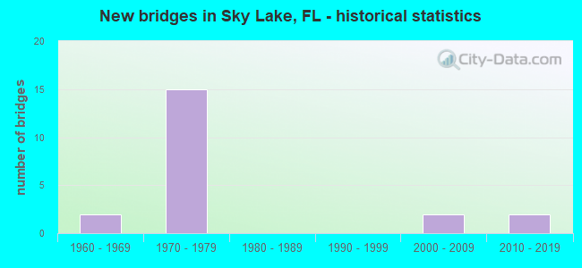
- New bridges - historical statistics
- 21960-1969
- 151970-1979
- 22000-2009
- 22010-2019

- Reconstructed bridges - Historical Statistics
- 32000-2009
- 42010-2019


- Bridge Condition - Deck
- 10.0%Very good
- 70.0%Good
- 20.0%Satisfactory

- Bridge Condition - Superstructure
- 80.0%Good
- 20.0%Satisfactory

- Bridge Condition - Substructure
- 10.0%Very good
- 80.0%Good
- 10.0%Satisfactory

- Bridge Condition - Channel
- 50.0%Good
- 50.0%Satisfactory

- Bridge Condition - Culverts
- 50.0%Good
- 50.0%Fair
Find on map >> Show street view
Structure Number: 750026, Location: 0.25 MI SOUTH OF SR 528 (Lat: 28.431856, Lng: -81.404778), Route carried "on" structure: Ramp State highway 91, Year Built: 1963, Status: Open, Structure Length: 4.97m (16.31ft), Average Daily Traffic: 16,500 (year 2020), Truck Traffic: 12%, Average Future Daily Traffic: 28,628 (year 2042), Design Load: H 20, Features Intersected: US 17 SR 500 (OBT)
Minimum Vertical Clearance: 30+ m (98+ ft), Kilometerpoint: 1.283, Lanes on structure: 1, Lanes under structure: 7, Toll: On toll road, Owner: State Toll Authority, Approaching Roadway Width: 5.5m (18.0ft), Skew: 31 degrees, Material/Design: Prestressed concrete, Design/Construction: Stringer/Multi-beam, Number Of Spans In Main Unit: 3, Length of Maximum Span: 27.2m (89.2ft), Curb or Sidewalk Widths: Left: 0.6m (2.0ft), Right: 0.6m (2.0ft), Curb-To-Curb Width: 5.5m (18.0ft), Out-to-Out Width: 13.0m (42.7ft)
Condition: Deck: Good, Superstructure: Satisfactory, Substructure: Good, Operating Rating: 64.0 metric tons, Method Used To Determine Operating Rating: Load and Resistance Factor (LRFR), Inventory Rating: 43.3 metric tons, Method Used To Determine Inventory Rating: Load and Resistance Factor (LRFR), Structural Evaluation: Equal to present minimum criteria, Deck Geometry: Meets minimum limits, Underclear: High priority of corrective action, Approach Roadway Alignment: Better than present minimum criteria, Designated Inspection Frequency: Every 24 months, Inspection Date: September 2021, Deck Structure Type: Concrete Cast-file-Place
Find on map >> Show street view
Structure Number: 750093, Location: 4.75 MI EAST OF I-4 (Lat: 28.434458, Lng: -81.404731), Route carried "on" structure: State highway 528, Year Built: 1973, Year Reconstructed: 2019, Status: Open, Structure Length: 12.39m (40.65ft), Average Daily Traffic: 19,025 (year 2020), Truck Traffic: 12%, Average Future Daily Traffic: 33,008 (year 2042), Design Load: HS 20, Features Intersected: US 441 US 17 US 92
Minimum Vertical Clearance: 30+ m (98+ ft), Kilometerpoint: 7.294, Lanes on structure: 5, Lanes under structure: 8, Base Highway Network: Yes, Toll: On toll road, Owner: State Toll Authority, Approaching Roadway Width: 26.8m (87.9ft), Skew: 2 degrees, Material/Design: Prestressed concrete, Design/Construction: Stringer/Multi-beam, Number Of Spans In Main Unit: 5, Length of Maximum Span: 34.5m (113.2ft), Curb-To-Curb Width: 26.8m (87.9ft), Out-to-Out Width: 27.8m (91.2ft)
Condition: Deck: Satisfactory, Superstructure: Satisfactory, Substructure: Satisfactory, Operating Rating: 39.6 metric tons, Method Used To Determine Operating Rating: Load and Resistance Factor (LRFR), Inventory Rating: 34.9 metric tons, Method Used To Determine Inventory Rating: Load and Resistance Factor (LRFR), Structural Evaluation: Equal to present minimum criteria, Deck Geometry: Superior to present desirable criteria, Underclear: High priority of corrective action, Approach Roadway Alignment: Equal to present desirable criteria, Designated Inspection Frequency: Every 23 months, Inspection Date: November 2021, Deck Structure Type: Concrete Cast-file-Place
Find on map >> Show street view
Structure Number: 750094, Location: 4.8 MI EAST OF I-4 (Lat: 28.435997, Lng: -81.401711), Route carried "on" structure: State highway 528, Year Built: 1973, Year Reconstructed: 2019, Status: Open, Structure Length: 6.64m (21.78ft), Average Daily Traffic: 42,350 (year 2020), Truck Traffic: 12%, Average Future Daily Traffic: 73,477 (year 2042), Design Load: HS 20, Features Intersected: LANDSTREET RD
Minimum Vertical Clearance: 30+ m (98+ ft), Kilometerpoint: 7.669, Lanes on structure: 4, Lanes under structure: 4, Base Highway Network: Yes, Toll: On toll road, Owner: State Toll Authority, Approaching Roadway Width: 21.0m (68.9ft), Skew: 4 degrees, Material/Design: Prestressed concrete, Design/Construction: Stringer/Multi-beam, Number Of Spans In Main Unit: 3, Length of Maximum Span: 29.6m (97.1ft), Curb-To-Curb Width: 21.0m (68.9ft), Out-to-Out Width: 21.7m (71.2ft)
Condition: Deck: Satisfactory, Superstructure: Good, Substructure: Good, Operating Rating: 42.5 metric tons, Method Used To Determine Operating Rating: Load and Resistance Factor (LRFR), Inventory Rating: 32.8 metric tons, Method Used To Determine Inventory Rating: Load and Resistance Factor (LRFR), Structural Evaluation: Better than present minimum criteria, Deck Geometry: Better than present minimum criteria, Underclear: High priority of corrective action, Approach Roadway Alignment: Equal to present desirable criteria, Designated Inspection Frequency: Every 24 months, Inspection Date: November 2021, Deck Structure Type: Concrete Cast-file-Place
Find on map >> Show street view
Structure Number: 750095, Location: 0.5 MI EAST OF SR-91 (Lat: 28.436019, Lng: -81.401067), Route carried "on" structure: Ramp State highway 528, Year Built: 1973, Status: Open, Structure Length: 6.31m (20.70ft), Average Daily Traffic: 7,900 (year 2020), Truck Traffic: 12%, Average Future Daily Traffic: 13,706 (year 2042), Design Load: HS 20, Features Intersected: LANDSTREET RD
Minimum Vertical Clearance: 30+ m (98+ ft), Kilometerpoint: 0.573, Lanes on structure: 2, Lanes under structure: 5, Toll: On toll road, Owner: State Toll Authority, Approaching Roadway Width: 13.0m (42.7ft), Skew: 4 degrees, Material/Design: Prestressed concrete, Design/Construction: Stringer/Multi-beam, Number Of Spans In Main Unit: 3, Length of Maximum Span: 28.2m (92.5ft), Curb-To-Curb Width: 13.0m (42.7ft), Out-to-Out Width: 13.9m (45.6ft)
Condition: Deck: Good, Superstructure: Good, Substructure: Good, Operating Rating: 50.0 metric tons, Method Used To Determine Operating Rating: Load and Resistance Factor (LRFR), Inventory Rating: 38.6 metric tons, Method Used To Determine Inventory Rating: Load and Resistance Factor (LRFR), Structural Evaluation: Better than present minimum criteria, Deck Geometry: Superior to present desirable criteria, Underclear: High priority of corrective action, Approach Roadway Alignment: Equal to present desirable criteria, Designated Inspection Frequency: Every 24 months, Inspection Date: November 2021, Deck Structure Type: Concrete Cast-file-Place
Find on map >> Show street view
Structure Number: 750096, Location: 0.65 MI EAST OF SR-91 (Lat: 28.437803, Lng: -81.399639), Route carried "on" structure: State highway 528, Year Built: 1973, Year Reconstructed: 2009, Status: Open, Structure Length: 4.94m (16.21ft), Average Daily Traffic: 42,350 (year 2020), Truck Traffic: 12%, Average Future Daily Traffic: 73,477 (year 2042), Design Load: HS 20, Features Intersected: SCL RR SPUR
Minimum Vertical Clearance: 30+ m (98+ ft), Kilometerpoint: 7.957, Lanes on structure: 4, Base Highway Network: Yes, Toll: On toll road, Owner: State Toll Authority, Approaching Roadway Width: 21.0m (68.9ft), Skew: 4 degrees, Material/Design: Prestressed concrete, Design/Construction: Stringer/Multi-beam, Number Of Spans In Main Unit: 3, Length of Maximum Span: 16.5m (54.1ft), Curb-To-Curb Width: 21.0m (68.9ft), Out-to-Out Width: 21.7m (71.2ft)
Condition: Deck: Good, Superstructure: Good, Substructure: Good, Operating Rating: 54.4 metric tons, Method Used To Determine Operating Rating: Load Factor (LF), Inventory Rating: 33.5 metric tons, Method Used To Determine Inventory Rating: Load Factor (LF), Structural Evaluation: Better than present minimum criteria, Deck Geometry: Better than present minimum criteria, Underclear: Meets minimum limits, Approach Roadway Alignment: Equal to present desirable criteria, Designated Inspection Frequency: Every 24 months, Inspection Date: November 2021, Deck Structure Type: Concrete Cast-file-Place
Find on map >> Show street view
Structure Number: 750181, Location: 4.75 MI EAST OF I-4 (Lat: 28.434181, Lng: -81.404867), Route carried "on" structure: State highway 528, Year Built: 1973, Year Reconstructed: 2019, Status: Open, Structure Length: 13.38m (43.90ft), Average Daily Traffic: 19,025 (year 2020), Truck Traffic: 12%, Average Future Daily Traffic: 33,008 (year 2042), Design Load: HS 20, Features Intersected: US 441 US 17 US 92
Minimum Vertical Clearance: 30+ m (98+ ft), Kilometerpoint: 7.276, Lanes on structure: 4, Lanes under structure: 8, Base Highway Network: Yes, Toll: On toll road, Owner: State Toll Authority, Approaching Roadway Width: 20.7m (67.9ft), Skew: 3 degrees, Material/Design: Prestressed concrete, Design/Construction: Stringer/Multi-beam, Number Of Spans In Main Unit: 6, Length of Maximum Span: 30.4m (99.7ft), Curb-To-Curb Width: 20.7m (67.9ft), Out-to-Out Width: 21.7m (71.2ft)
Condition: Deck: Good, Superstructure: Good, Substructure: Good, Operating Rating: 42.8 metric tons, Method Used To Determine Operating Rating: Load and Resistance Factor (LRFR), Inventory Rating: 33.0 metric tons, Method Used To Determine Inventory Rating: Load and Resistance Factor (LRFR), Structural Evaluation: Better than present minimum criteria, Deck Geometry: Equal to present minimum criteria, Underclear: High priority of corrective action, Approach Roadway Alignment: Equal to present desirable criteria, Designated Inspection Frequency: Every 24 months, Inspection Date: November 2021, Deck Structure Type: Concrete Cast-file-Place
Find on map >> Show street view
Structure Number: 750221, Location: 0.5 MI EAST OF SR-91 (Lat: 28.435992, Lng: -81.401372), Route carried "on" structure: State highway 528, Year Built: 1973, Year Reconstructed: 2019, Status: Open, Structure Length: 6.64m (21.78ft), Average Daily Traffic: 42,350 (year 2020), Truck Traffic: 12%, Average Future Daily Traffic: 73,477 (year 2042), Design Load: HS 20, Features Intersected: LANDSTREET RD
Minimum Vertical Clearance: 30+ m (98+ ft), Kilometerpoint: 7.707, Lanes on structure: 4, Lanes under structure: 4, Base Highway Network: Yes, Toll: On toll road, Owner: State Toll Authority, Approaching Roadway Width: 20.9m (68.6ft), Skew: 4 degrees, Material/Design: Prestressed concrete, Design/Construction: Stringer/Multi-beam, Number Of Spans In Main Unit: 3, Length of Maximum Span: 29.6m (97.1ft), Curb-To-Curb Width: 20.9m (68.6ft), Out-to-Out Width: 21.7m (71.2ft)
Condition: Deck: Good, Superstructure: Good, Substructure: Good, Operating Rating: 49.7 metric tons, Method Used To Determine Operating Rating: Load and Resistance Factor (LRFR), Inventory Rating: 38.4 metric tons, Method Used To Determine Inventory Rating: Load and Resistance Factor (LRFR), Structural Evaluation: Better than present minimum criteria, Deck Geometry: Better than present minimum criteria, Underclear: High priority of corrective action, Approach Roadway Alignment: Equal to present desirable criteria, Designated Inspection Frequency: Every 24 months, Inspection Date: November 2021, Deck Structure Type: Concrete Cast-file-Place
Find on map >> Show street view
Structure Number: 750222, Location: 0.67 MI EAST OF SR-91 (Lat: 28.437797, Lng: -81.399317), Route carried "on" structure: State highway 528, Year Built: 1973, Year Reconstructed: 2009, Status: Open, Structure Length: 4.94m (16.21ft), Average Daily Traffic: 42,350 (year 2020), Truck Traffic: 12%, Average Future Daily Traffic: 73,477 (year 2042), Design Load: HS 20, Features Intersected: SCL RR SPUR
Minimum Vertical Clearance: 30+ m (98+ ft), Kilometerpoint: 7.995, Lanes on structure: 3, Base Highway Network: Yes, Toll: On toll road, Owner: State Toll Authority, Approaching Roadway Width: 22.5m (73.8ft), Skew: 4 degrees, Material/Design: Prestressed concrete, Design/Construction: Stringer/Multi-beam, Number Of Spans In Main Unit: 3, Length of Maximum Span: 16.5m (54.1ft), Curb-To-Curb Width: 22.5m (73.8ft), Out-to-Out Width: 24.3m (79.7ft)
Condition: Deck: Good, Superstructure: Good, Substructure: Good, Operating Rating: 54.5 metric tons, Method Used To Determine Operating Rating: Load Factor (LF), Inventory Rating: 33.5 metric tons, Method Used To Determine Inventory Rating: Load Factor (LF), Structural Evaluation: Better than present minimum criteria, Deck Geometry: Superior to present desirable criteria, Underclear: Meets minimum limits, Approach Roadway Alignment: Equal to present desirable criteria, Designated Inspection Frequency: Every 24 months, Inspection Date: November 2021, Deck Structure Type: Concrete Cast-file-Place
Find on map >> Show street view
Structure Number: 7506, Location: 0.9 MI EAST OF SR-91 (Lat: 28.440422, Lng: -81.396447), Route carried "on" structure: State highway 528, Year Built: 1973, Year Reconstructed: 2009, Status: Open, Structure Length: 0.64m (2.10ft), Average Daily Traffic: 84,700 (year 2020), Truck Traffic: 12%, Average Future Daily Traffic: 146,954 (year 2042), Design Load: HS 20, Features Intersected: DRAINAGE CANAL
Minimum Vertical Clearance: 30+ m (98+ ft), Kilometerpoint: 8.418, Lanes on structure: 9, Base Highway Network: Yes, Toll: On toll road, Owner: State Toll Authority, Approaching Roadway Width: 48.2m (158.1ft), Skew: 33 degrees, Material/Design: Concrete, Design/Construction: Culvert, Number Of Spans In Main Unit: 2, Length of Maximum Span: 3.0m (9.8ft)
Condition: Channel: Satisfactory, Culverts: Fair, Operating Rating: 60.8 metric tons, Method Used To Determine Operating Rating: Load and Resistance Factor (LRFR), Inventory Rating: 47.0 metric tons, Method Used To Determine Inventory Rating: Load and Resistance Factor (LRFR), Structural Evaluation: Somewhat better than minimum adequacy, Waterway Adequacy: Better than present minimum criteria, Approach Roadway Alignment: Better than present minimum criteria, Designated Inspection Frequency: Every 24 months, Inspection Date: December 2021
Find on map >> Show street view
Structure Number: 750632, Location: 0.2MI E OF LANDSTREET RD (Lat: 28.437806, Lng: -81.399072), Route carried "on" structure: Ramp State highway 528, Year Built: 2009, Status: Open, Structure Length: 4.71m (15.45ft), Average Daily Traffic: 7,900 (year 2020), Truck Traffic: 12%, Average Future Daily Traffic: 13,706 (year 2042), Design Load: HS 20, Features Intersected: SCLRR SPUR
Minimum Vertical Clearance: 30+ m (98+ ft), Kilometerpoint: 0.864, Lanes on structure: 2, Toll: On toll road, Owner: State Toll Authority, Approaching Roadway Width: 12.2m (40.0ft), Skew: 6 degrees, Material/Design: Prestressed concrete, Design/Construction: Stringer/Multi-beam, Number Of Spans In Main Unit: 2, Length of Maximum Span: 31.5m (103.3ft), Curb-To-Curb Width: 12.2m (40.0ft), Out-to-Out Width: 13.1m (43.0ft)
Condition: Deck: Good, Superstructure: Good, Substructure: Good, Operating Rating: 61.9 metric tons, Method Used To Determine Operating Rating: Load Factor (LF), Inventory Rating: 37.1 metric tons, Method Used To Determine Inventory Rating: Load Factor (LF), Structural Evaluation: Better than present minimum criteria, Deck Geometry: Superior to present desirable criteria, Underclear: Somewhat better than minimum adequacy, Approach Roadway Alignment: Equal to present desirable criteria, Designated Inspection Frequency: Every 24 months, Inspection Date: November 2021, Deck Structure Type: Concrete Cast-file-Place
Find on map >> Show street view
Structure Number: 750645, Location: 0.25 MI SOUTH OF SR 528 (Lat: 28.431722, Lng: -81.404778), Route carried "on" structure: Ramp State highway 91, Year Built: 2018, Status: Open, Structure Length: 4.88m (16.01ft), Average Daily Traffic: 16,400 (year 2016), Truck Traffic: 15%, Average Future Daily Traffic: 28,454 (year 2038), Design Load: HL 93, Features Intersected: US 17 SR 500 (OBT)
Minimum Vertical Clearance: 30+ m (98+ ft), Kilometerpoint: 0.467, Lanes on structure: 2, Lanes under structure: 7, Toll: On toll road, Owner: State Toll Authority, Approaching Roadway Width: 12.2m (40.0ft), Skew: 1 degrees, Material/Design: Prestressed concrete, Design/Construction: Stringer/Multi-beam, Number Of Spans In Main Unit: 1, Length of Maximum Span: 48.8m (160.1ft), Curb-To-Curb Width: 12.2m (40.0ft), Out-to-Out Width: 13.1m (43.0ft)
Condition: Deck: Very good, Superstructure: Good, Substructure: Very good, Operating Rating: 63.2 metric tons, Method Used To Determine Operating Rating: Load and Resistance Factor (LRFR), Inventory Rating: 44.5 metric tons, Method Used To Determine Inventory Rating: Load and Resistance Factor (LRFR), Structural Evaluation: Better than present minimum criteria, Deck Geometry: Superior to present desirable criteria, Underclear: High priority of corrective action, Approach Roadway Alignment: Better than present minimum criteria, Designated Inspection Frequency: Every 24 months, Inspection Date: September 2021, Deck Structure Type: Concrete Cast-file-Place
Find on map >> Show street view
Structure Number: 754134, Location: 0.2mi S. of US-441/US-17 (Lat: 28.454525, Lng: -81.395750), Route carried "on" structure: City street , Year Built: 2003, Status: Open, Structure Length: 0.91m (2.99ft), Average Daily Traffic: 2,108 (year 2020), Truck Traffic: 5%, Average Future Daily Traffic: 2,468 (year 2042), Design Load: HS 20, Features Intersected: Skyview Creek, Facility Carried by Structure: Skyview Drive
Minimum Vertical Clearance: 30+ m (98+ ft), Kilometerpoint: 0.016, Lanes on structure: 2, Owner: County Highway Agency, Approaching Roadway Width: 7.6m (24.9ft), Material/Design: Concrete, Design/Construction: Culvert, Number Of Spans In Main Unit: 1, Length of Maximum Span: 8.5m (27.9ft), Curb or Sidewalk Widths: Left: 2.0m (6.6ft), Right: 2.0m (6.6ft), Curb-To-Curb Width: 7.6m (24.9ft), Out-to-Out Width: 12.5m (41.0ft)
Condition: Channel: Good, Culverts: Good, Operating Rating: 59.7 metric tons, Method Used To Determine Operating Rating: Load Factor (LF), Inventory Rating: 35.8 metric tons, Method Used To Determine Inventory Rating: Load Factor (LF), Structural Evaluation: Better than present minimum criteria, Deck Geometry: High priority of replacement, Waterway Adequacy: Equal to present desirable criteria, Approach Roadway Alignment: Better than present minimum criteria, Designated Inspection Frequency: Every 24 months, Inspection Date: March 2020
Find on map >> Show street view
Structure Number: 750026, Location: 0.25 MI SOUTH OF SR 528 (Lat: 28.431856, Lng: -81.404778), Route carried "under" structure: US 17, Year Built: 1963, Structure Length: 0. m, Average Daily Traffic: 64,000 (year 2020), Truck Traffic: 5%, Features Intersected: US 17 SR 500 (OBT), Facility Carried by Structure: SR 91 RMP 255.6
Minimum Vertical Clearance: 4.98m (16.34ft), Kilometerpoint: 9.288, Lanes on structure: 1, Lanes under structure: 7, Material/Design: Prestressed concrete, Design/Construction: Stringer/Multi-beam, Length of Maximum Span: 27.2m (89.2ft)
Find on map >> Show street view
Structure Number: 750093, Location: 4.75 MI EAST OF I-4 (Lat: 28.434458, Lng: -81.404731), Route carried "under" structure: Ramp State highway 91, Year Built: 1973, Structure Length: 0. m, Average Daily Traffic: 5,100 (year 2020), Truck Traffic: 12%, Features Intersected: US 441 US 17 US 92, Facility Carried by Structure: SR 528 WB 4.6
Minimum Vertical Clearance: 5.58m (18.31ft), Kilometerpoint: 0.016, Lanes on structure: 5, Lanes under structure: 2, Toll: On toll road, Material/Design: Prestressed concrete, Design/Construction: Stringer/Multi-beam, Length of Maximum Span: 34.5m (113.2ft)
Find on map >> Show street view
Structure Number: 750093, Location: 4.75 MI EAST OF I-4 (Lat: 28.434458, Lng: -81.404731), Route carried "under" structure: US 17, Year Built: 1973, Structure Length: 0. m, Average Daily Traffic: 19,025 (year 2020), Truck Traffic: 12%, Features Intersected: US 441 US 17 US 92, Facility Carried by Structure: SR 528 WB 4.6
Minimum Vertical Clearance: 5.18m (16.99ft), Kilometerpoint: 9.595, Lanes on structure: 5, Lanes under structure: 6, Material/Design: Prestressed concrete, Design/Construction: Stringer/Multi-beam, Length of Maximum Span: 34.5m (113.2ft)
Find on map >> Show street view
Structure Number: 750094, Location: 4.8 MI EAST OF I-4 (Lat: 28.435997, Lng: -81.401711), Route carried "under" structure: County highway 528, Year Built: 1973, Structure Length: 0. m, Average Daily Traffic: 42,350 (year 2020), Truck Traffic: 12%, Features Intersected: LANDSTREET RD
Minimum Vertical Clearance: 5.21m (17.09ft), Kilometerpoint: 9.362, Lanes on structure: 4, Lanes under structure: 4, Material/Design: Prestressed concrete, Design/Construction: Stringer/Multi-beam, Length of Maximum Span: 29.6m (97.1ft)
Find on map >> Show street view
Structure Number: 750095, Location: 0.5 MI EAST OF SR-91 (Lat: 28.436019, Lng: -81.401067), Route carried "under" structure: County highway 528, Year Built: 1973, Structure Length: 0. m, Average Daily Traffic: 18,100 (year 2020), Truck Traffic: 7%, Features Intersected: LANDSTREET RD
Minimum Vertical Clearance: 5.24m (17.19ft), Kilometerpoint: 9.419, Lanes on structure: 2, Lanes under structure: 5, Material/Design: Prestressed concrete, Design/Construction: Stringer/Multi-beam, Length of Maximum Span: 28.2m (92.5ft)
Find on map >> Show street view
Structure Number: 750181, Location: 4.75 MI EAST OF I-4 (Lat: 28.434181, Lng: -81.404867), Route carried "under" structure: US 17, Year Built: 1973, Structure Length: 0. m, Average Daily Traffic: 19,025 (year 2020), Truck Traffic: 12%, Features Intersected: US 441 US 17 US 92, Facility Carried by Structure: SR 528 EB 4.6
Minimum Vertical Clearance: 5.97m (19.59ft), Kilometerpoint: 9.547, Lanes on structure: 4, Lanes under structure: 6, Material/Design: Prestressed concrete, Design/Construction: Stringer/Multi-beam, Length of Maximum Span: 30.4m (99.7ft)
Find on map >> Show street view
Structure Number: 750181, Location: 4.75 MI EAST OF I-4 (Lat: 28.434181, Lng: -81.404867), Route carried "under" structure: Ramp State highway 91, Year Built: 1973, Structure Length: 0. m, Average Daily Traffic: 5,100 (year 2020), Truck Traffic: 12%, Features Intersected: US 441 US 17 US 92, Facility Carried by Structure: SR 528 EB 4.6
Minimum Vertical Clearance: 5.09m (16.70ft), Kilometerpoint: 0.032, Lanes on structure: 4, Lanes under structure: 2, Toll: On toll road, Material/Design: Prestressed concrete, Design/Construction: Stringer/Multi-beam, Length of Maximum Span: 30.4m (99.7ft)
Find on map >> Show street view
Structure Number: 750221, Location: 0.5 MI EAST OF SR-91 (Lat: 28.435992, Lng: -81.401372), Route carried "under" structure: County highway 528, Year Built: 1973, Structure Length: 0. m, Average Daily Traffic: 18,100 (year 2020), Truck Traffic: 7%, Features Intersected: LANDSTREET RD
Minimum Vertical Clearance: 5.87m (19.26ft), Kilometerpoint: 9.391, Lanes on structure: 4, Lanes under structure: 4, Material/Design: Prestressed concrete, Design/Construction: Stringer/Multi-beam, Length of Maximum Span: 29.6m (97.1ft)
Find on map >> Show street view
Structure Number: 750645, Location: 0.25 MI SOUTH OF SR 528 (Lat: 28.431722, Lng: -81.404778), Route carried "under" structure: US 17, Year Built: 2018, Structure Length: 0. m, Average Daily Traffic: 58,000 (year 2016), Truck Traffic: 6%, Features Intersected: US 17 SR 500 (OBT), Facility Carried by Structure: SR 91 RAMP 255.6
Minimum Vertical Clearance: 5.09m (16.70ft), Kilometerpoint: 9.288, Lanes on structure: 2, Lanes under structure: 7, Material/Design: Prestressed concrete, Design/Construction: Stringer/Multi-beam, Length of Maximum Span: 48.8m (160.1ft)