Bridge Statistics for Shelby, Ohio (OH)
Condition, Traffic, Stress, Structural Evaluation, Project Costs
- National Bridge Inventory (NBI) Statistics
- 36Number of bridges
- 285ft / 87.1mTotal length
- $344,846,000Total costs
- 112,510Total average daily traffic
- 11,822Total average daily truck traffic
- 157,968Total future (year 2010) average daily traffic
- National Bridge Inventory (NBI) Registered Bridges for Shelby
- No street view available for this location
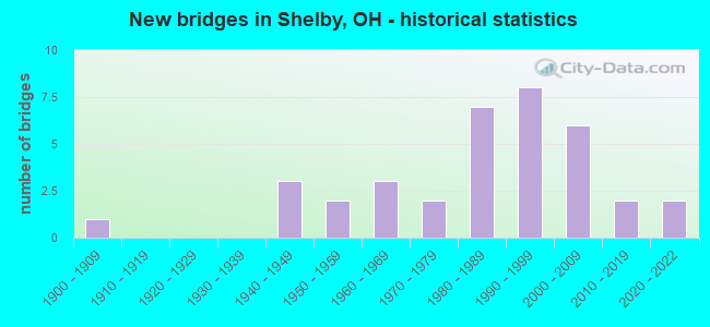
- New bridges - historical statistics
- 11900-1909
- 31940-1949
- 21950-1959
- 31960-1969
- 21970-1979
- 71980-1989
- 81990-1999
- 62000-2009
- 22010-2019
- 22020-2022

- Reconstructed bridges - Historical Statistics
- 21970-1979
- 11980-1989
- 31990-1999
- 22000-2009


- Bridge Condition - Deck
- 29.4%Excellent
- 11.8%Very good
- 23.5%Good
- 14.7%Satisfactory
- 14.7%Fair
- 2.9%Poor
- 2.9%Serious

- Bridge Condition - Superstructure
- 31.4%Excellent
- 14.3%Very good
- 22.9%Good
- 8.6%Satisfactory
- 17.1%Fair
- 2.9%Poor
- 2.9%Serious

- Bridge Condition - Substructure
- 34.3%Excellent
- 14.3%Very good
- 20.0%Good
- 22.9%Satisfactory
- 5.7%Fair
- 2.9%Serious

- Bridge Condition - Channel
- 17.1%Excellent
- 28.6%Very good
- 31.4%Good
- 8.6%Satisfactory
- 11.4%Fair
- 2.9%Serious
Find on map >> Show street view
Structure Number: 706397, Location: .08 M E OF SR 7 (Lat: 40.049661, Lng: -80.731961), Route carried "on" structure: Interstate 470, Year Built: 1978, Status: Open, Structure Length: 23.92m (78.48ft), Average Daily Traffic: 42,161 (year 2019), Truck Traffic: 16%, Average Future Daily Traffic: 60,488 (year 2039), Design Load: HS 20, Features Intersected: SR7 N.S.RR & OH RIVER
Minimum Vertical Clearance: 5.18m (16.99ft), Kilometerpoint: 10.525, Lanes on structure: 4, Base Highway Network: Yes, Owner: State Highway Agency, Approaching Roadway Width: 28.0m (91.9ft), Skew: 30 degrees, Navigation Control: Yes ( Vertical Clearance: 21.0m (68.9ft), Horizontal Clearance: 230.1m (754.9ft)), Material/Design: Steel continuous, Design/Construction: Stringer/Multi-beam, Number Of Spans In Main Unit: 1, Length of Maximum Span: 237.7m (779.9ft), Curb-To-Curb Width: 25.5m (83.7ft), Out-to-Out Width: 27.4m (89.9ft)
Condition: Deck: Satisfactory, Superstructure: Fair, Substructure: Fair, Channel: Very good, Operating Rating: 42.1 metric tons, Method Used To Determine Operating Rating: Load Factor (LF) rating reported by rating factor (RF) method using MS18 loading, Inventory Rating: 29.2 metric tons, Method Used To Determine Inventory Rating: Load Factor (LF) rating reported by rating factor (RF) method using MS18 loading, Structural Evaluation: Somewhat better than minimum adequacy, Deck Geometry: Equal to present desirable criteria, Waterway Adequacy: Superior to present desirable criteria, Approach Roadway Alignment: Superior to present desirable criteria, Length Of Structure Improvement: 17.96m (58.92ft), Designated Inspection Frequency: Every 24 months, Critical Feature Inspection Frequency: Every 12 months, Underwater Inspection Frequency: Every 60 months, Other Special Inspection Frequency: Every 12 months, Inspection Date: April 2020, Critical Feature Inspection Date: April 2021, Underwater Inspection Date: September 2021, Other Special Inspection Date: April 2021, Bridge Improvement Cost: $150,000, Roadway Improvement Cost: $20,000, Total Project Cost: $170,000, Deck Structure Type: Concrete Cast-file-Place, Wearing Surface/Protective System: Wearing Surface: Latex Concrete, Deck Protection: Epoxy Coated Reinforcing
Find on map >> Show street view
Structure Number: 7001975, Location: .12 MI E SR 61 (Lat: 40.881369, Lng: -82.659500), Route carried "on" structure: State highway 39, Year Built: 1983, Status: Open, Structure Length: 1.74m (5.71ft), Average Daily Traffic: 7,643 (year 2015), Truck Traffic: 6%, Average Future Daily Traffic: 10,608 (year 2035), Design Load: HS 20+Mod, Features Intersected: BLACK FORK CREEK
Minimum Vertical Clearance: 30+ m (98+ ft), Kilometerpoint: 5.665, Lanes on structure: 2, Owner: State Highway Agency, Approaching Roadway Width: 12.8m (42.0ft), Material/Design: Prestressed concrete, Design/Construction: Box Beam or Girders - Multiple, Number Of Spans In Main Unit: 1, Length of Maximum Span: 17.1m (56.1ft), Curb or Sidewalk Widths: Left: 2.8m (9.2ft), Right: 3.4m (11.2ft), Curb-To-Curb Width: 13.4m (44.0ft), Out-to-Out Width: 20.3m (66.6ft)
Condition: Deck: Fair, Superstructure: Fair, Substructure: Fair, Channel: Fair, Operating Rating: 42.1 metric tons, Method Used To Determine Operating Rating: Allowable Stress (AS) rating reported by rating factor (RF) method using MS18 loading, Inventory Rating: 32.4 metric tons, Method Used To Determine Inventory Rating: Allowable Stress (AS) rating reported by rating factor (RF) method using MS18 loading, Structural Evaluation: Somewhat better than minimum adequacy, Deck Geometry: Equal to present minimum criteria, Waterway Adequacy: Meets minimum limits, Approach Roadway Alignment: Equal to present desirable criteria, Designated Inspection Frequency: Every 12 months, Inspection Date: March 2021, Deck Structure Type: Concrete Cast-file-Place, Wearing Surface/Protective System: Wearing Surface: Bituminous, Membrane: Built-up
Find on map >> Show street view
Structure Number: 7002017, Location: 3.88 MILES S OF CRA CO (Lat: 40.878511, Lng: -82.655819), Route carried "on" structure: State highway 39, Year Built: 1963, Year Reconstructed: 1997, Status: Open, Structure Length: 0.75m (2.46ft), Average Daily Traffic: 11,880 (year 2015), Truck Traffic: 7%, Average Future Daily Traffic: 16,489 (year 2035), Design Load: HS 20+Mod, Features Intersected: BR OF BLACK FORK
Minimum Vertical Clearance: 30+ m (98+ ft), Kilometerpoint: 6.244, Lanes on structure: 2, Owner: State Highway Agency, Approaching Roadway Width: 9.1m (29.9ft), Skew: 2 degrees, Material/Design: Concrete, Design/Construction: Slab, Number Of Spans In Main Unit: 1, Length of Maximum Span: 6.7m (22.0ft), Curb or Sidewalk Widths: Left: 1.5m (4.9ft), Right: 1.5m (4.9ft), Curb-To-Curb Width: 9.1m (29.9ft), Out-to-Out Width: 12.9m (42.3ft)
Condition: Deck: Good, Superstructure: Good, Substructure: Good, Channel: Satisfactory, Operating Rating: 42.1 metric tons, Method Used To Determine Operating Rating: Allowable Stress (AS) rating reported by rating factor (RF) method using MS18 loading, Inventory Rating: 32.4 metric tons, Method Used To Determine Inventory Rating: Allowable Stress (AS) rating reported by rating factor (RF) method using MS18 loading, Structural Evaluation: Better than present minimum criteria, Deck Geometry: High priority of corrective action, Waterway Adequacy: Superior to present desirable criteria, Approach Roadway Alignment: Better than present minimum criteria, Designated Inspection Frequency: Every 24 months, Inspection Date: April 2021, Deck Structure Type: Concrete Cast-file-Place, Wearing Surface/Protective System: Wearing Surface: Monolithic Concrete, Deck Protection: Epoxy Coated Reinforcing
Find on map >> Show street view
Structure Number: 7003129, Location: .41 N SR 314 (Lat: 40.850161, Lng: -82.670911), Route carried "on" structure: State highway 61, Year Built: 1940, Year Reconstructed: 1986, Status: Open, Structure Length: 2.41m (7.91ft), Average Daily Traffic: 683 (year 2015), Truck Traffic: 5%, Average Future Daily Traffic: 948 (year 2035), Design Load: H 15, Features Intersected: BR OF BLACK FORK
Minimum Vertical Clearance: 30+ m (98+ ft), Kilometerpoint: 5.568, Lanes on structure: 2, Owner: State Highway Agency, Approaching Roadway Width: 9.8m (32.2ft), Skew: 2 degrees, Material/Design: Prestressed concrete continuous, Design/Construction: Box Beam or Girders - Multiple, Number Of Spans In Main Unit: 2, Length of Maximum Span: 11.6m (38.1ft), Curb-To-Curb Width: 9.8m (32.2ft), Out-to-Out Width: 9.8m (32.2ft)
Condition: Deck: Good, Superstructure: Good, Substructure: Satisfactory, Channel: Satisfactory, Operating Rating: 42.1 metric tons, Method Used To Determine Operating Rating: Load Factor (LF) rating reported by rating factor (RF) method using MS18 loading, Inventory Rating: 32.4 metric tons, Method Used To Determine Inventory Rating: Load Factor (LF) rating reported by rating factor (RF) method using MS18 loading, Structural Evaluation: Equal to present minimum criteria, Deck Geometry: Equal to present minimum criteria, Waterway Adequacy: Superior to present desirable criteria, Approach Roadway Alignment: Equal to present desirable criteria, Length Of Structure Improvement: 3.60m (11.81ft), Designated Inspection Frequency: Every 12 months, Inspection Date: March 2021, Bridge Improvement Cost: $208,000, Roadway Improvement Cost: $21,000, Total Project Cost: $494,000, Deck Structure Type: Concrete Cast-file-Place, Wearing Surface/Protective System: Wearing Surface: Bituminous, Membrane: Built-up
Find on map >> Show street view
Structure Number: 7003145, Location: 0.08 MILES NORTH OF SR314 (Lat: 40.863761, Lng: -82.663331), Route carried "on" structure: State highway 61, Year Built: 1997, Status: Open, Structure Length: 1.74m (5.71ft), Average Daily Traffic: 4,208 (year 2015), Truck Traffic: 9%, Average Future Daily Traffic: 5,841 (year 2035), Design Load: HS 20+Mod, Features Intersected: BRANCH BLACK FORK RIVER
Minimum Vertical Clearance: 30+ m (98+ ft), Kilometerpoint: 7.741, Lanes on structure: 2, Owner: State Highway Agency, Approaching Roadway Width: 12.2m (40.0ft), Skew: 1 degrees, Material/Design: Prestressed concrete, Design/Construction: Box Beam or Girders - Multiple, Number Of Spans In Main Unit: 1, Length of Maximum Span: 16.5m (54.1ft), Curb-To-Curb Width: 12.2m (40.0ft), Out-to-Out Width: 12.2m (40.0ft)
Condition: Deck: Good, Superstructure: Good, Substructure: Very good, Channel: Good, Operating Rating: 42.1 metric tons, Method Used To Determine Operating Rating: Load Factor (LF) rating reported by rating factor (RF) method using MS18 loading, Inventory Rating: 32.4 metric tons, Method Used To Determine Inventory Rating: Load Factor (LF) rating reported by rating factor (RF) method using MS18 loading, Structural Evaluation: Better than present minimum criteria, Deck Geometry: Equal to present minimum criteria, Waterway Adequacy: Superior to present desirable criteria, Approach Roadway Alignment: Better than present minimum criteria, Designated Inspection Frequency: Every 24 months, Inspection Date: March 2021, Deck Structure Type: Concrete Cast-file-Place, Wearing Surface/Protective System: Wearing Surface: Monolithic Concrete
Find on map >> Show street view
Structure Number: 7003196, Location: 2.56 MI N SR 39 (Lat: 40.917250, Lng: -82.657139), Route carried "on" structure: State highway 61, Year Built: 1986, Status: Open, Structure Length: 2.87m (9.42ft), Average Daily Traffic: 3,654 (year 2018), Truck Traffic: 11%, Average Future Daily Traffic: 5,072 (year 2038), Design Load: HS 20, Features Intersected: MARSH CREEK
Minimum Vertical Clearance: 30+ m (98+ ft), Kilometerpoint: 13.840, Lanes on structure: 2, Owner: State Highway Agency, Approaching Roadway Width: 12.2m (40.0ft), Skew: 1 degrees, Material/Design: Concrete continuous, Design/Construction: Slab, Number Of Spans In Main Unit: 3, Length of Maximum Span: 10.7m (35.1ft), Curb-To-Curb Width: 12.1m (39.7ft), Out-to-Out Width: 12.2m (40.0ft)
Condition: Deck: Satisfactory, Superstructure: Satisfactory, Substructure: Good, Channel: Fair, Operating Rating: 42.1 metric tons, Method Used To Determine Operating Rating: Load Factor (LF) rating reported by rating factor (RF) method using MS18 loading, Inventory Rating: 32.4 metric tons, Method Used To Determine Inventory Rating: Load Factor (LF) rating reported by rating factor (RF) method using MS18 loading, Structural Evaluation: Equal to present minimum criteria, Deck Geometry: Somewhat better than minimum adequacy, Waterway Adequacy: Better than present minimum criteria, Approach Roadway Alignment: Equal to present minimum criteria, Designated Inspection Frequency: Every 12 months, Inspection Date: May 2021, Deck Structure Type: Concrete Cast-file-Place, Wearing Surface/Protective System: Wearing Surface: Monolithic Concrete, Deck Protection: Galvanized Reinforcing
Find on map >> Show street view
Structure Number: 700518, Location: 5.62 MI E OF CRAWFORD CO (Lat: 40.879419, Lng: -82.620211), Route carried "on" structure: State highway 96, Year Built: 1986, Status: Open, Structure Length: 1.46m (4.79ft), Average Daily Traffic: 1,778 (year 2018), Truck Traffic: 11%, Average Future Daily Traffic: 2,468 (year 2038), Design Load: HS 20+Mod, Features Intersected: BEAR RUN
Minimum Vertical Clearance: 30+ m (98+ ft), Kilometerpoint: 9.045, Lanes on structure: 2, Owner: State Highway Agency, Approaching Roadway Width: 10.4m (34.1ft), Skew: 1 degrees, Material/Design: Concrete continuous, Design/Construction: Slab, Number Of Spans In Main Unit: 3, Length of Maximum Span: 5.5m (18.0ft), Curb-To-Curb Width: 10.4m (34.1ft), Out-to-Out Width: 10.4m (34.1ft)
Condition: Deck: Good, Superstructure: Good, Substructure: Satisfactory, Channel: Fair, Operating Rating: 42.1 metric tons, Method Used To Determine Operating Rating: Allowable Stress (AS) rating reported by rating factor (RF) method using MS18 loading, Inventory Rating: 32.4 metric tons, Method Used To Determine Inventory Rating: Allowable Stress (AS) rating reported by rating factor (RF) method using MS18 loading, Structural Evaluation: Equal to present minimum criteria, Deck Geometry: Equal to present minimum criteria, Waterway Adequacy: Better than present minimum criteria, Approach Roadway Alignment: Equal to present minimum criteria, Designated Inspection Frequency: Every 12 months, Inspection Date: May 2021, Deck Structure Type: Concrete Cast-file-Place, Wearing Surface/Protective System: Wearing Surface: Monolithic Concrete
Find on map >> Show street view
Structure Number: 7005237, Location: 6.22 MI E.OF CRAWFORD CO. (Lat: 40.882711, Lng: -82.609611), Route carried "on" structure: State highway 96, Year Built: 2006, Status: Open, Structure Length: 1.28m (4.20ft), Average Daily Traffic: 1,778 (year 2018), Truck Traffic: 11%, Average Future Daily Traffic: 2,468 (year 2038), Design Load: HS 20+Mod, Features Intersected: LEATHERWOOD CREEK
Minimum Vertical Clearance: 30+ m (98+ ft), Kilometerpoint: 10.010, Lanes on structure: 2, Owner: State Highway Agency, Approaching Roadway Width: 10.8m (35.4ft), Material/Design: Prestressed concrete, Design/Construction: Box Beam or Girders - Multiple, Number Of Spans In Main Unit: 1, Length of Maximum Span: 12.4m (40.7ft), Curb-To-Curb Width: 11.0m (36.1ft), Out-to-Out Width: 11.0m (36.1ft)
Condition: Deck: Very good, Superstructure: Very good, Substructure: Excellent, Channel: Good, Operating Rating: 42.1 metric tons, Method Used To Determine Operating Rating: Load Factor (LF) rating reported by rating factor (RF) method using MS18 loading, Inventory Rating: 32.4 metric tons, Method Used To Determine Inventory Rating: Load Factor (LF) rating reported by rating factor (RF) method using MS18 loading, Structural Evaluation: Equal to present desirable criteria, Deck Geometry: Equal to present minimum criteria, Waterway Adequacy: Better than present minimum criteria, Approach Roadway Alignment: Equal to present desirable criteria, Designated Inspection Frequency: Every 24 months, Inspection Date: May 2021, Deck Structure Type: Concrete Cast-file-Place, Wearing Surface/Protective System: Wearing Surface: Bituminous, Membrane: Preformed Fabric
Find on map >> Show street view
Structure Number: 7005245, Location: 7.60 MI E OF CRAWFORD CO (Lat: 40.888531, Lng: -82.584800), Route carried "on" structure: State highway 96, Year Built: 1983, Status: Open, Structure Length: 0.73m (2.40ft), Average Daily Traffic: 1,778 (year 2018), Truck Traffic: 11%, Average Future Daily Traffic: 2,468 (year 2038), Design Load: HS 20+Mod, Features Intersected: DRAINAGE DITCH
Minimum Vertical Clearance: 30+ m (98+ ft), Kilometerpoint: 12.231, Lanes on structure: 2, Owner: State Highway Agency, Approaching Roadway Width: 8.5m (27.9ft), Skew: 1 degrees, Material/Design: Concrete, Design/Construction: Slab, Number Of Spans In Main Unit: 1, Length of Maximum Span: 6.1m (20.0ft), Curb-To-Curb Width: 10.4m (34.1ft), Out-to-Out Width: 10.4m (34.1ft)
Condition: Deck: Good, Superstructure: Good, Substructure: Satisfactory, Channel: Fair, Operating Rating: 42.1 metric tons, Method Used To Determine Operating Rating: Allowable Stress (AS) rating reported by rating factor (RF) method using MS18 loading, Inventory Rating: 32.4 metric tons, Method Used To Determine Inventory Rating: Allowable Stress (AS) rating reported by rating factor (RF) method using MS18 loading, Structural Evaluation: Equal to present minimum criteria, Deck Geometry: Equal to present minimum criteria, Waterway Adequacy: Equal to present desirable criteria, Approach Roadway Alignment: Equal to present desirable criteria, Designated Inspection Frequency: Every 12 months, Inspection Date: May 2021, Deck Structure Type: Concrete Cast-file-Place, Wearing Surface/Protective System: Wearing Surface: Monolithic Concrete
Find on map >> Show street view
Structure Number: 7005261, Location: 8.07 MI E OF CRAWFORD CO (Lat: 40.890850, Lng: -82.576461), Route carried "on" structure: State highway 96, Year Built: 1983, Status: Open, Structure Length: 0.73m (2.40ft), Average Daily Traffic: 1,778 (year 2018), Truck Traffic: 11%, Average Future Daily Traffic: 2,468 (year 2038), Design Load: HS 20+Mod, Features Intersected: DRAINAGE DITCH
Minimum Vertical Clearance: 30+ m (98+ ft), Kilometerpoint: 12.987, Lanes on structure: 2, Owner: State Highway Agency, Approaching Roadway Width: 8.5m (27.9ft), Material/Design: Concrete, Design/Construction: Slab, Number Of Spans In Main Unit: 1, Length of Maximum Span: 6.1m (20.0ft), Curb-To-Curb Width: 10.4m (34.1ft), Out-to-Out Width: 10.4m (34.1ft)
Condition: Deck: Good, Superstructure: Good, Substructure: Good, Channel: Good, Operating Rating: 42.1 metric tons, Method Used To Determine Operating Rating: Allowable Stress (AS) rating reported by rating factor (RF) method using MS18 loading, Inventory Rating: 32.4 metric tons, Method Used To Determine Inventory Rating: Allowable Stress (AS) rating reported by rating factor (RF) method using MS18 loading, Structural Evaluation: Better than present minimum criteria, Deck Geometry: Equal to present minimum criteria, Waterway Adequacy: Superior to present desirable criteria, Approach Roadway Alignment: Equal to present desirable criteria, Designated Inspection Frequency: Every 24 months, Inspection Date: May 2021, Deck Structure Type: Concrete Cast-file-Place, Wearing Surface/Protective System: Wearing Surface: Monolithic Concrete
Find on map >> Show street view
Structure Number: 7030097, Location: 250' EAST OF SR 314 (Lat: 40.828450, Lng: -82.654689), Route carried "on" structure: Other road T0169, Year Built: 2021, Status: Open, Structure Length: 1.10m (3.61ft), Average Daily Traffic: 570 (year 2021), Truck Traffic: 2%, Average Future Daily Traffic: 700 (year 2042), Design Load: HL 93, Features Intersected: TRIB. OF BLACK FORK RIV., Facility Carried by Structure: STEIN RD
Minimum Vertical Clearance: 30+ m (98+ ft), Kilometerpoint: 3.685, Lanes on structure: 2, Owner: County Highway Agency, Approaching Roadway Width: 8.5m (27.9ft), Material/Design: Prestressed concrete, Design/Construction: Box Beam or Girders - Multiple, Number Of Spans In Main Unit: 1, Length of Maximum Span: 10.7m (35.1ft), Curb-To-Curb Width: 8.5m (27.9ft), Out-to-Out Width: 8.5m (27.9ft)
Condition: Deck: Excellent, Superstructure: Excellent, Substructure: Excellent, Channel: Excellent, Operating Rating: 49.9 metric tons, Method Used To Determine Operating Rating: Load and Resistance Factor Rating (LRFR) rating reported by rating factor(RF) method using HL-93 loadings, Inventory Rating: 38.6 metric tons, Method Used To Determine Inventory Rating: Load and Resistance Factor Rating (LRFR) rating reported by rating factor(RF) method using HL-93 loadings, Structural Evaluation: Superior to present desirable criteria, Deck Geometry: Somewhat better than minimum adequacy, Waterway Adequacy: Superior to present desirable criteria, Approach Roadway Alignment: Equal to present desirable criteria, Designated Inspection Frequency: Every 12 months, Inspection Date: October 2021, Deck Structure Type: Concrete Cast-file-Place, Wearing Surface/Protective System: Wearing Surface: Bituminous, Membrane: Preformed Fabric, Deck Protection: Other
Find on map >> Show street view
Structure Number: 7030185, Location: 0.2 MI EAST OF SR. 61 (Lat: 40.896581, Lng: -82.657761), Route carried "on" structure: County highway C0061, Year Built: 1955, Status: Open, Structure Length: 4.02m (13.19ft), Average Daily Traffic: 1,889 (year 2015), Truck Traffic: 16%, Average Future Daily Traffic: 2,622 (year 2038), Design Load: H 20, Features Intersected: BLACK FORK RIVER, Facility Carried by Structure: STATE ST.
Minimum Vertical Clearance: 30+ m (98+ ft), Kilometerpoint: 2.398, Lanes on structure: 2, Owner: County Highway Agency, Approaching Roadway Width: 7.3m (24.0ft), Skew: 2 degrees, Material/Design: Steel continuous, Design/Construction: Stringer/Multi-beam, Number Of Spans In Main Unit: 3, Length of Maximum Span: 15.2m (49.9ft), Curb-To-Curb Width: 11.0m (36.1ft), Out-to-Out Width: 11.6m (38.1ft)
Condition: Deck: Serious, Superstructure: Fair, Substructure: Satisfactory, Channel: Good, Operating Rating: 32.4 metric tons, Method Used To Determine Operating Rating: Load Factor (LF) rating reported by rating factor (RF) method using MS18 loading, Inventory Rating: 19.4 metric tons, Method Used To Determine Inventory Rating: Load Factor (LF) rating reported by rating factor (RF) method using MS18 loading, Structural Evaluation: Somewhat better than minimum adequacy, Deck Geometry: Equal to present minimum criteria, Waterway Adequacy: Equal to present desirable criteria, Approach Roadway Alignment: Equal to present desirable criteria, Designated Inspection Frequency: Every 12 months, Inspection Date: May 2021, Deck Structure Type: Concrete Cast-file-Place, Wearing Surface/Protective System: Wearing Surface: Bituminous
Find on map >> Show street view
Structure Number: 7030291, Location: 0.2 MI E of PlySpringmill (Lat: 40.898931, Lng: -82.620369), Route carried "on" structure: County highway C0061, Year Built: 2020, Status: Open, Structure Length: 1.25m (4.10ft), Average Daily Traffic: 435 (year 2016), Truck Traffic: 5%, Average Future Daily Traffic: 540 (year 2036), Design Load: HL 93, Features Intersected: Bear Run, Facility Carried by Structure: Shelby Ganges Rd
Minimum Vertical Clearance: 30+ m (98+ ft), Kilometerpoint: 5.745, Lanes on structure: 2, Owner: County Highway Agency, Approaching Roadway Width: 6.1m (20.0ft), Material/Design: Prestressed concrete, Design/Construction: Box Beam or Girders - Multiple, Number Of Spans In Main Unit: 1, Length of Maximum Span: 12.2m (40.0ft), Curb-To-Curb Width: 8.5m (27.9ft), Out-to-Out Width: 8.5m (27.9ft)
Condition: Deck: Excellent, Superstructure: Excellent, Substructure: Excellent, Channel: Excellent, Operating Rating: 29.2 metric tons, Method Used To Determine Operating Rating: Load and Resistance Factor Rating (LRFR) rating reported by rating factor(RF) method using HL-93 loadings, Inventory Rating: 22.7 metric tons, Method Used To Determine Inventory Rating: Load and Resistance Factor Rating (LRFR) rating reported by rating factor(RF) method using HL-93 loadings, Structural Evaluation: Equal to present minimum criteria, Deck Geometry: Somewhat better than minimum adequacy, Waterway Adequacy: Superior to present desirable criteria, Approach Roadway Alignment: Equal to present desirable criteria, Designated Inspection Frequency: Every 12 months, Inspection Date: June 2021, Deck Structure Type: Concrete Cast-file-Place, Wearing Surface/Protective System: Wearing Surface: Bituminous, Membrane: Preformed Fabric, Deck Protection: Other
Find on map >> Show street view
Structure Number: 7030436, Location: 200' SO. OF SR 96 (Lat: 40.878800, Lng: -82.620689), Route carried "on" structure: County highway C0191, Year Built: 2003, Status: Open, Structure Length: 1.74m (5.71ft), Average Daily Traffic: 2,745 (year 2015), Truck Traffic: 5%, Average Future Daily Traffic: 3,810 (year 2038), Design Load: HS 20+Mod, Features Intersected: BEAR RUN, Facility Carried by Structure: PLY- SPRINGMILL RD
Minimum Vertical Clearance: 30+ m (98+ ft), Kilometerpoint: 6.051, Lanes on structure: 2, Owner: County Highway Agency, Approaching Roadway Width: 13.4m (44.0ft), Material/Design: Prestressed concrete, Design/Construction: Box Beam or Girders - Multiple, Number Of Spans In Main Unit: 1, Length of Maximum Span: 17.4m (57.1ft), Curb-To-Curb Width: 12.2m (40.0ft), Out-to-Out Width: 12.2m (40.0ft)
Condition: Deck: Very good, Superstructure: Very good, Substructure: Excellent, Channel: Very good, Operating Rating: 42.1 metric tons, Method Used To Determine Operating Rating: Load Factor (LF) rating reported by rating factor (RF) method using MS18 loading, Inventory Rating: 32.4 metric tons, Method Used To Determine Inventory Rating: Load Factor (LF) rating reported by rating factor (RF) method using MS18 loading, Structural Evaluation: Equal to present desirable criteria, Deck Geometry: Equal to present minimum criteria, Waterway Adequacy: Superior to present desirable criteria, Approach Roadway Alignment: Equal to present desirable criteria, Designated Inspection Frequency: Every 24 months, Inspection Date: June 2021, Deck Structure Type: Concrete Cast-file-Place, Wearing Surface/Protective System: Wearing Surface: Bituminous, Membrane: Built-up, Deck Protection: Other
Find on map >> Show street view
Structure Number: 7030819, Location: 0.7MI N. OF LONDON WEST (Lat: 40.917600, Lng: -82.705019), Route carried "on" structure: County highway C0182, Year Built: 1944, Status: Posted for load, Structure Length: 0.85m (2.79ft), Average Daily Traffic: 385 (year 2018), Truck Traffic: 8%, Average Future Daily Traffic: 534 (year 2038), Design Load: HS 20, Features Intersected: MARSH RUN, Facility Carried by Structure: CHAMPION RD.
Minimum Vertical Clearance: 30+ m (98+ ft), Kilometerpoint: 2.832, Lanes on structure: 2, Owner: County Highway Agency, Approaching Roadway Width: 7.3m (24.0ft), Material/Design: Concrete, Design/Construction: Slab, Number Of Spans In Main Unit: 1, Length of Maximum Span: 7.3m (24.0ft), Curb-To-Curb Width: 6.9m (22.6ft), Out-to-Out Width: 7.3m (24.0ft)
Condition: Deck: Fair, Superstructure: Fair, Substructure: Satisfactory, Channel: Good, Operating Rating: 16.2 metric tons, Method Used To Determine Operating Rating: Allowable Stress (AS) rating reported by rating factor (RF) method using MS18 loading, Inventory Rating: 9.7 metric tons, Method Used To Determine Inventory Rating: Allowable Stress (AS) rating reported by rating factor (RF) method using MS18 loading, Structural Evaluation: High priority of replacement, Deck Geometry: Meets minimum limits, Waterway Adequacy: Somewhat better than minimum adequacy, Approach Roadway Alignment: Equal to present desirable criteria, Bridge Posting: Required (Relationship of Operating Rating to Maximum Legal Load: > 39.9% below), Length Of Structure Improvement: 1.49m (4.89ft), Designated Inspection Frequency: Every 12 months, Inspection Date: April 2021, Bridge Improvement Cost: $154,000, Roadway Improvement Cost: $14,000, Total Project Cost: $168,000, Deck Structure Type: Concrete Cast-file-Place, Wearing Surface/Protective System: Wearing Surface: Bituminous
Find on map >> Show street view
Structure Number: 7030975, Location: 1.1MI.N.OF SR 61 (Lat: 40.918539, Lng: -82.676239), Route carried "on" structure: County highway T0185, Year Built: 1900, Year Reconstructed: 1981, Status: Posted for load, Structure Length: 1.08m (3.54ft), Average Daily Traffic: 155 (year 2018), Truck Traffic: 8%, Average Future Daily Traffic: 215 (year 2038), Design Load: HS 20+Mod, Features Intersected: MARSH RUN, Facility Carried by Structure: SHOUP RD.
Minimum Vertical Clearance: 30+ m (98+ ft), Kilometerpoint: 1.786, Lanes on structure: 1, Owner: County Highway Agency, Approaching Roadway Width: 4.9m (16.1ft), Material/Design: Steel, Design/Construction: Stringer/Multi-beam, Number Of Spans In Main Unit: 1, Length of Maximum Span: 9.7m (31.8ft), Curb-To-Curb Width: 5.2m (17.1ft), Out-to-Out Width: 5.6m (18.4ft)
Condition: Deck: Fair, Superstructure: Poor, Substructure: Satisfactory, Channel: Good, Operating Rating: 25.9 metric tons, Method Used To Determine Operating Rating: Load Factor (LF) rating reported by rating factor (RF) method using MS18 loading, Inventory Rating: 16.2 metric tons, Method Used To Determine Inventory Rating: Load Factor (LF) rating reported by rating factor (RF) method using MS18 loading, Structural Evaluation: Meets minimum limits, Deck Geometry: High priority of replacement, Waterway Adequacy: Equal to present desirable criteria, Approach Roadway Alignment: Equal to present minimum criteria, Bridge Posting: Required (Relationship of Operating Rating to Maximum Legal Load: > 39.9% below), Length Of Structure Improvement: 1.71m (5.61ft), Designated Inspection Frequency: Every 12 months, Inspection Date: April 2021, Bridge Improvement Cost: $180,000, Roadway Improvement Cost: $17,000, Total Project Cost: $197,000, Deck Structure Type: Corrugated Steel, Wearing Surface/Protective System: Wearing Surface: Bituminous
Find on map >> Show street view
Structure Number: 7031262, Location: .1 MI NO.OF SHELBY GANGES (Lat: 40.900881, Lng: -82.625581), Route carried "on" structure: County highway C0191, Year Built: 1995, Status: Open, Structure Length: 1.13m (3.71ft), Average Daily Traffic: 1,803 (year 2015), Truck Traffic: 7%, Average Future Daily Traffic: 2,503 (year 2038), Design Load: HS 20+Mod, Features Intersected: BEAR RUN, Facility Carried by Structure: PLY-SPRINGMILL RD.
Minimum Vertical Clearance: 30+ m (98+ ft), Kilometerpoint: 8.594, Lanes on structure: 2, Owner: County Highway Agency, Approaching Roadway Width: 7.0m (23.0ft), Skew: 1 degrees, Material/Design: Prestressed concrete, Design/Construction: Box Beam or Girders - Multiple, Number Of Spans In Main Unit: 1, Length of Maximum Span: 10.7m (35.1ft), Curb-To-Curb Width: 8.5m (27.9ft), Out-to-Out Width: 8.5m (27.9ft)
Condition: Deck: Excellent, Superstructure: Excellent, Substructure: Excellent, Channel: Very good, Operating Rating: 42.1 metric tons, Method Used To Determine Operating Rating: Allowable Stress (AS) rating reported by rating factor (RF) method using MS18 loading, Inventory Rating: 32.4 metric tons, Method Used To Determine Inventory Rating: Allowable Stress (AS) rating reported by rating factor (RF) method using MS18 loading, Structural Evaluation: Equal to present desirable criteria, Deck Geometry: Somewhat better than minimum adequacy, Waterway Adequacy: Equal to present minimum criteria, Approach Roadway Alignment: Equal to present desirable criteria, Designated Inspection Frequency: Every 24 months, Inspection Date: June 2021, Deck Structure Type: Concrete Cast-file-Place, Wearing Surface/Protective System: Wearing Surface: Bituminous, Membrane: Built-up
Find on map >> Show street view
Structure Number: 70313, Location: 0.5MI N OF LONDON W RD. (Lat: 40.915969, Lng: -82.633489), Route carried "on" structure: County highway C0191, Year Built: 1965, Year Reconstructed: 1998, Status: Posted for load, Structure Length: 2.77m (9.09ft), Average Daily Traffic: 1,803 (year 2018), Truck Traffic: 7%, Average Future Daily Traffic: 2,503 (year 2038), Features Intersected: BLACK FORK MOHICAN RIVER, Facility Carried by Structure: PLY-SPRINGMILL RD.
Minimum Vertical Clearance: 30+ m (98+ ft), Kilometerpoint: 10.573, Lanes on structure: 2, Owner: County Highway Agency, Approaching Roadway Width: 6.7m (22.0ft), Material/Design: Steel, Design/Construction: Truss - Thru, Number Of Spans In Main Unit: 1, Length of Maximum Span: 26.2m (86.0ft), Curb-To-Curb Width: 8.5m (27.9ft), Out-to-Out Width: 9.3m (30.5ft)
Condition: Deck: Fair, Superstructure: Very good, Substructure: Very good, Channel: Good, Operating Rating: 25.9 metric tons, Method Used To Determine Operating Rating: Load Factor (LF) rating reported by rating factor (RF) method using MS18 loading, Inventory Rating: 16.2 metric tons, Method Used To Determine Inventory Rating: Load Factor (LF) rating reported by rating factor (RF) method using MS18 loading, Structural Evaluation: Meets minimum limits, Deck Geometry: Somewhat better than minimum adequacy, Waterway Adequacy: Somewhat better than minimum adequacy, Approach Roadway Alignment: Equal to present minimum criteria, Bridge Posting: Required (Relationship of Operating Rating to Maximum Legal Load: 30.0 - 39.9% below), Length Of Structure Improvement: 3.60m (11.81ft), Designated Inspection Frequency: Every 12 months, Critical Feature Inspection Frequency: Every 24 months, Inspection Date: April 2021, Critical Feature Inspection Date: April 2021, Bridge Improvement Cost: $141,000, Roadway Improvement Cost: $14,000, Total Project Cost: $255,000, Deck Structure Type: Corrugated Steel, Wearing Surface/Protective System: Wearing Surface: Bituminous
Find on map >> Show street view
Structure Number: 7032021, Location: .35 MI. EAST FO SR 314 (Lat: 40.843119, Lng: -82.653089), Route carried "on" structure: County highway C0201, Year Built: 2003, Status: Open, Structure Length: 2.01m (6.59ft), Average Daily Traffic: 1,397 (year 2015), Truck Traffic: 5%, Average Future Daily Traffic: 1,939 (year 2038), Design Load: HS 20+Mod, Features Intersected: WEST BLACK FORK, Facility Carried by Structure: MYERS ROAD
Minimum Vertical Clearance: 30+ m (98+ ft), Kilometerpoint: 0.563, Lanes on structure: 2, Owner: County Highway Agency, Approaching Roadway Width: 9.1m (29.9ft), Material/Design: Prestressed concrete, Design/Construction: Box Beam or Girders - Multiple, Number Of Spans In Main Unit: 1, Length of Maximum Span: 19.8m (65.0ft), Curb-To-Curb Width: 9.1m (29.9ft), Out-to-Out Width: 9.1m (29.9ft)
Condition: Deck: Excellent, Superstructure: Excellent, Substructure: Excellent, Channel: Excellent, Operating Rating: 42.1 metric tons, Method Used To Determine Operating Rating: Load Factor (LF) rating reported by rating factor (RF) method using MS18 loading, Inventory Rating: 32.4 metric tons, Method Used To Determine Inventory Rating: Load Factor (LF) rating reported by rating factor (RF) method using MS18 loading, Structural Evaluation: Equal to present desirable criteria, Deck Geometry: Somewhat better than minimum adequacy, Waterway Adequacy: Superior to present desirable criteria, Approach Roadway Alignment: Equal to present desirable criteria, Designated Inspection Frequency: Every 24 months, Inspection Date: May 2021, Deck Structure Type: Concrete Cast-file-Place, Wearing Surface/Protective System: Wearing Surface: Bituminous, Membrane: Built-up, Deck Protection: Other
Find on map >> Show street view
Structure Number: 7032307, Location: .2 MI NORTH OF MILLER RD (Lat: 40.925319, Lng: -82.614350), Route carried "on" structure: County highway C0215, Year Built: 1998, Status: Open, Structure Length: 3.66m (12.01ft), Average Daily Traffic: 1,320 (year 2018), Truck Traffic: 18%, Average Future Daily Traffic: 1,832 (year 2038), Design Load: HS 20+Mod, Features Intersected: BLACKFORK MOHICAN RIVER, Facility Carried by Structure: BOWMAN ST. RD.
Minimum Vertical Clearance: 30+ m (98+ ft), Kilometerpoint: 20.728, Lanes on structure: 2, Owner: County Highway Agency, Approaching Roadway Width: 13.4m (44.0ft), Material/Design: Prestressed concrete, Design/Construction: Box Beam or Girders - Multiple, Number Of Spans In Main Unit: 3, Length of Maximum Span: 14.0m (45.9ft), Curb-To-Curb Width: 12.2m (40.0ft), Out-to-Out Width: 12.2m (40.0ft)
Condition: Deck: Very good, Superstructure: Very good, Substructure: Very good, Channel: Excellent, Operating Rating: 58.3 metric tons, Method Used To Determine Operating Rating: Load Factor (LF) rating reported by rating factor (RF) method using MS18 loading, Inventory Rating: 35.6 metric tons, Method Used To Determine Inventory Rating: Load Factor (LF) rating reported by rating factor (RF) method using MS18 loading, Structural Evaluation: Equal to present desirable criteria, Deck Geometry: Better than present minimum criteria, Waterway Adequacy: Superior to present desirable criteria, Approach Roadway Alignment: Equal to present desirable criteria, Designated Inspection Frequency: Every 24 months, Inspection Date: April 2021, Deck Structure Type: Concrete Cast-file-Place, Wearing Surface/Protective System: Wearing Surface: Bituminous, Membrane: Built-up, Deck Protection: Other
Find on map >> Show street view
Structure Number: 7033044, Location: 0.1 MI W. OF BROADWAY (Lat: 40.908461, Lng: -82.656850), Route carried "on" structure: County highway C0058, Year Built: 1970, Year Reconstructed: 2000, Status: Posted for load, Structure Length: 2.68m (8.79ft), Average Daily Traffic: 1,497 (year 2018), Truck Traffic: 5%, Average Future Daily Traffic: 2,078 (year 2038), Design Load: HS 20+Mod, Features Intersected: BLACK FORK MOHICAN RIVER, Facility Carried by Structure: LONDON WEST
Minimum Vertical Clearance: 30+ m (98+ ft), Kilometerpoint: 5.810, Lanes on structure: 2, Owner: County Highway Agency, Approaching Roadway Width: 7.9m (25.9ft), Material/Design: Steel, Design/Construction: Stringer/Multi-beam, Number Of Spans In Main Unit: 3, Length of Maximum Span: 10.1m (33.1ft), Curb-To-Curb Width: 7.9m (25.9ft), Out-to-Out Width: 8.5m (27.9ft)
Condition: Deck: Poor, Superstructure: Serious, Substructure: Satisfactory, Channel: Satisfactory, Operating Rating: 6.5 metric tons, Method Used To Determine Operating Rating: Load Factor (LF) rating reported by rating factor (RF) method using MS18 loading, Inventory Rating: 3.2 metric tons, Method Used To Determine Inventory Rating: Load Factor (LF) rating reported by rating factor (RF) method using MS18 loading, Structural Evaluation: High priority of replacement, Deck Geometry: Meets minimum limits, Waterway Adequacy: Somewhat better than minimum adequacy, Approach Roadway Alignment: Equal to present minimum criteria, Bridge Posting: Required (Relationship of Operating Rating to Maximum Legal Load: > 39.9% below), Length Of Structure Improvement: 3.47m (11.38ft), Designated Inspection Frequency: Every 12 months, Inspection Date: April 2021, Bridge Improvement Cost: $249,000, Roadway Improvement Cost: $12,000, Total Project Cost: $261,000, Deck Structure Type: Corrugated Steel, Wearing Surface/Protective System: Wearing Surface: Bituminous
Find on map >> Show street view
Structure Number: 7033788, Location: .5 MI. SOUTH OF SR 39 (Lat: 40.873400, Lng: -82.677169), Route carried "on" structure: County highway C0171, Year Built: 1998, Status: Open, Structure Length: 1.16m (3.81ft), Average Daily Traffic: 1,158 (year 2015), Truck Traffic: 5%, Average Future Daily Traffic: 1,607 (year 2038), Design Load: HS 20+Mod, Features Intersected: UNNAMED STREAM, Facility Carried by Structure: HUMMEL/VERNON RD.
Minimum Vertical Clearance: 30+ m (98+ ft), Kilometerpoint: 5.198, Lanes on structure: 2, Owner: County Highway Agency, Approaching Roadway Width: 8.5m (27.9ft), Material/Design: Concrete, Design/Construction: Arch - Deck, Number Of Spans In Main Unit: 1, Length of Maximum Span: 11.0m (36.1ft), Curb-To-Curb Width: 8.5m (27.9ft), Out-to-Out Width: 8.5m (27.9ft)
Condition: Superstructure: Good, Substructure: Excellent, Channel: Very good, Operating Rating: 29.2 metric tons, Method Used To Determine Operating Rating: Load Factor (LF) rating reported by rating factor (RF) method using MS18 loading, Inventory Rating: 22.7 metric tons, Method Used To Determine Inventory Rating: Load Factor (LF) rating reported by rating factor (RF) method using MS18 loading, Structural Evaluation: Equal to present minimum criteria, Deck Geometry: Somewhat better than minimum adequacy, Waterway Adequacy: Superior to present desirable criteria, Approach Roadway Alignment: Equal to present desirable criteria, Designated Inspection Frequency: Every 24 months, Inspection Date: May 2021, Wearing Surface/Protective System: Wearing Surface: Bituminous
Find on map >> Show street view
Structure Number: 7034016, Location: 0.4 MI S. OF SR 39 (Lat: 40.863611, Lng: -82.643531), Route carried "on" structure: County highway T0212, Year Built: 2009, Status: Open, Structure Length: 1.00m (3.28ft), Average Daily Traffic: 797 (year 2015), Truck Traffic: 8%, Average Future Daily Traffic: 1,106 (year 2038), Design Load: HL 93, Features Intersected: TRIB. BLACK-FORK RIVER, Facility Carried by Structure: GEORGE HAWK RD.
Minimum Vertical Clearance: 30+ m (98+ ft), Kilometerpoint: 2.366, Lanes on structure: 2, Owner: County Highway Agency, Approaching Roadway Width: 7.3m (24.0ft), Skew: 4 degrees, Material/Design: Concrete, Design/Construction: Frame, Number Of Spans In Main Unit: 1, Length of Maximum Span: 9.1m (29.9ft), Curb-To-Curb Width: 7.4m (24.3ft), Out-to-Out Width: 27.7m (90.9ft)
Condition: Deck: Excellent, Superstructure: Excellent, Substructure: Excellent, Channel: Very good, Operating Rating: 42.1 metric tons, Method Used To Determine Operating Rating: Load and Resistance Factor Rating (LRFR) rating reported by rating factor(RF) method using HL-93 loadings, Inventory Rating: 32.4 metric tons, Method Used To Determine Inventory Rating: Load and Resistance Factor Rating (LRFR) rating reported by rating factor(RF) method using HL-93 loadings, Structural Evaluation: Equal to present desirable criteria, Deck Geometry: Meets minimum limits, Waterway Adequacy: Better than present minimum criteria, Approach Roadway Alignment: Equal to present desirable criteria, Designated Inspection Frequency: Every 24 months, Inspection Date: June 2021, Deck Structure Type: Concrete Cast-file-Place, Wearing Surface/Protective System: Wearing Surface: Bituminous, Membrane: Preformed Fabric, Deck Protection: Other
Find on map >> Show street view
Structure Number: 7034385, Location: .88 MI SO. OF MYERS (Lat: 40.834231, Lng: -82.643369), Route carried "on" structure: County highway T0168, Year Built: 2003, Status: Open, Structure Length: 1.59m (5.22ft), Average Daily Traffic: 324 (year 2015), Truck Traffic: 7%, Average Future Daily Traffic: 450 (year 2038), Design Load: HS 20+Mod, Features Intersected: BLACK FORK MOHICAN RIVER, Facility Carried by Structure: STIVING ROAD
Minimum Vertical Clearance: 30+ m (98+ ft), Kilometerpoint: 4.200, Lanes on structure: 2, Owner: County Highway Agency, Approaching Roadway Width: 11.0m (36.1ft), Material/Design: Prestressed concrete, Design/Construction: Box Beam or Girders - Multiple, Number Of Spans In Main Unit: 1, Length of Maximum Span: 14.9m (48.9ft), Curb-To-Curb Width: 9.8m (32.2ft), Out-to-Out Width: 9.8m (32.2ft)
Condition: Deck: Satisfactory, Superstructure: Excellent, Substructure: Excellent, Channel: Very good, Operating Rating: 42.1 metric tons, Method Used To Determine Operating Rating: Load Factor (LF) rating reported by rating factor (RF) method using MS18 loading, Inventory Rating: 32.4 metric tons, Method Used To Determine Inventory Rating: Load Factor (LF) rating reported by rating factor (RF) method using MS18 loading, Structural Evaluation: Equal to present desirable criteria, Deck Geometry: Better than present minimum criteria, Waterway Adequacy: Equal to present desirable criteria, Approach Roadway Alignment: Equal to present minimum criteria, Designated Inspection Frequency: Every 12 months, Inspection Date: June 2021, Deck Structure Type: Concrete Cast-file-Place, Wearing Surface/Protective System: Wearing Surface: Monolithic Concrete, Deck Protection: Epoxy Coated Reinforcing
Find on map >> Show street view
Structure Number: 7034431, Location: 0.2 MILE E OF STIVING RD. (Lat: 40.828369, Lng: -82.636361), Route carried "on" structure: County highway T0169, Year Built: 2006, Status: Open, Structure Length: 1.72m (5.64ft), Average Daily Traffic: 324 (year 2015), Truck Traffic: 7%, Average Future Daily Traffic: 450 (year 2038), Design Load: HS 20, Features Intersected: BLACK FORK OF MOHICAN RI, Facility Carried by Structure: (TR.169) STEIN RD.
Minimum Vertical Clearance: 30+ m (98+ ft), Kilometerpoint: 5.295, Lanes on structure: 2, Owner: County Highway Agency, Approaching Roadway Width: 8.5m (27.9ft), Skew: 3 degrees, Material/Design: Prestressed concrete, Design/Construction: Box Beam or Girders - Multiple, Number Of Spans In Main Unit: 1, Length of Maximum Span: 16.8m (55.1ft), Curb-To-Curb Width: 8.5m (27.9ft), Out-to-Out Width: 8.5m (27.9ft)
Condition: Deck: Excellent, Superstructure: Excellent, Substructure: Excellent, Channel: Excellent, Operating Rating: 48.6 metric tons, Method Used To Determine Operating Rating: Load and Resistance Factor Rating (LRFR) rating reported by rating factor(RF) method using HL-93 loadings, Inventory Rating: 35.6 metric tons, Method Used To Determine Inventory Rating: Load and Resistance Factor Rating (LRFR) rating reported by rating factor(RF) method using HL-93 loadings, Structural Evaluation: Superior to present desirable criteria, Deck Geometry: Equal to present minimum criteria, Waterway Adequacy: Superior to present desirable criteria, Approach Roadway Alignment: Equal to present desirable criteria, Length Of Structure Improvement: 2.93m (9.61ft), Designated Inspection Frequency: Every 24 months, Inspection Date: June 2021, Bridge Improvement Cost: $193,000, Roadway Improvement Cost: $74,000, Total Project Cost: $267,000, Deck Structure Type: Concrete Cast-file-Place, Wearing Surface/Protective System: Wearing Surface: Bituminous, Membrane: Preformed Fabric, Deck Protection: Other
Find on map >> Show street view
Structure Number: 7034555, Location: 0.9 MI E. OF BOWMAN ST RD (Lat: 40.902450, Lng: -82.582469), Route carried "on" structure: County highway C0061, Year Built: 2010, Status: Open, Structure Length: 0.91m (2.99ft), Average Daily Traffic: 385 (year 2018), Truck Traffic: 8%, Average Future Daily Traffic: 534 (year 2038), Design Load: HS 20+Mod, Features Intersected: TRIB OF BLACKFORK RIVER, Facility Carried by Structure: SHELBY-GANGES RD.
Minimum Vertical Clearance: 30+ m (98+ ft), Kilometerpoint: 8.996, Lanes on structure: 2, Owner: County Highway Agency, Approaching Roadway Width: 8.5m (27.9ft), Skew: 4 degrees, Material/Design: Concrete, Design/Construction: Frame, Number Of Spans In Main Unit: 1, Length of Maximum Span: 8.5m (27.9ft), Curb-To-Curb Width: 8.5m (27.9ft), Out-to-Out Width: 16.8m (55.1ft)
Condition: Deck: Excellent, Superstructure: Excellent, Substructure: Excellent, Channel: Very good, Operating Rating: 58.3 metric tons, Method Used To Determine Operating Rating: Load Factor (LF) rating reported by rating factor (RF) method using MS18 loading, Inventory Rating: 35.6 metric tons, Method Used To Determine Inventory Rating: Load Factor (LF) rating reported by rating factor (RF) method using MS18 loading, Structural Evaluation: Superior to present desirable criteria, Deck Geometry: Equal to present minimum criteria, Waterway Adequacy: Superior to present desirable criteria, Approach Roadway Alignment: Equal to present desirable criteria, Designated Inspection Frequency: Every 24 months, Inspection Date: May 2021, Deck Structure Type: Concrete Cast-file-Place, Wearing Surface/Protective System: Wearing Surface: Bituminous, Membrane: Preformed Fabric, Deck Protection: Other
Find on map >> Show street view
Structure Number: 703547, Location: .4 MI E.OF HUMMEL RD. (Lat: 40.857031, Lng: -82.669539), Route carried "on" structure: County highway T0435, Year Built: 1962, Year Reconstructed: 2004, Status: Open, Structure Length: 1.01m (3.31ft), Average Daily Traffic: 951 (year 2015), Truck Traffic: 5%, Average Future Daily Traffic: 1,320 (year 2038), Features Intersected: UNNAMED STREAM, Facility Carried by Structure: WEIDNER RD.
Minimum Vertical Clearance: 30+ m (98+ ft), Kilometerpoint: 0.692, Lanes on structure: 2, Owner: County Highway Agency, Approaching Roadway Width: 7.3m (24.0ft), Material/Design: Steel, Design/Construction: Stringer/Multi-beam, Number Of Spans In Main Unit: 1, Length of Maximum Span: 9.1m (29.9ft), Curb-To-Curb Width: 7.3m (24.0ft), Out-to-Out Width: 7.6m (24.9ft)
Condition: Deck: Excellent, Superstructure: Excellent, Substructure: Good, Channel: Very good, Operating Rating: 61.6 metric tons, Method Used To Determine Operating Rating: Load Factor (LF) rating reported by rating factor (RF) method using MS18 loading, Inventory Rating: 35.6 metric tons, Method Used To Determine Inventory Rating: Load Factor (LF) rating reported by rating factor (RF) method using MS18 loading, Structural Evaluation: Better than present minimum criteria, Deck Geometry: Meets minimum limits, Waterway Adequacy: Somewhat better than minimum adequacy, Approach Roadway Alignment: Equal to present desirable criteria, Length Of Structure Improvement: 1.62m (5.31ft), Designated Inspection Frequency: Every 24 months, Inspection Date: May 2021, Bridge Improvement Cost: $117,000, Roadway Improvement Cost: $17,000, Total Project Cost: $135,000, Deck Structure Type: Corrugated Steel, Wearing Surface/Protective System: Wearing Surface: Bituminous
Find on map >> Show street view
Structure Number: 7035535, Location: .1MI EAST OF PLY SPRMILL (Lat: 40.886439, Lng: -82.617881), Route carried "on" structure: County highway T0057, Year Built: 1991, Status: Open, Structure Length: 1.46m (4.79ft), Average Daily Traffic: 306 (year 2015), Truck Traffic: 5%, Average Future Daily Traffic: 425 (year 2038), Design Load: HS 20+Mod, Features Intersected: BEAR RUN, Facility Carried by Structure: SMILEY AVE EAST
Minimum Vertical Clearance: 30+ m (98+ ft), Kilometerpoint: 9.399, Lanes on structure: 2, Owner: County Highway Agency, Approaching Roadway Width: 7.3m (24.0ft), Skew: 1 degrees, Material/Design: Prestressed concrete, Design/Construction: Box Beam or Girders - Multiple, Number Of Spans In Main Unit: 1, Length of Maximum Span: 13.7m (44.9ft), Curb-To-Curb Width: 8.5m (27.9ft), Out-to-Out Width: 8.5m (27.9ft)
Condition: Deck: Excellent, Superstructure: Excellent, Substructure: Excellent, Channel: Very good, Operating Rating: 42.1 metric tons, Method Used To Determine Operating Rating: Allowable Stress (AS) rating reported by rating factor (RF) method using MS18 loading, Inventory Rating: 32.4 metric tons, Method Used To Determine Inventory Rating: Allowable Stress (AS) rating reported by rating factor (RF) method using MS18 loading, Structural Evaluation: Equal to present desirable criteria, Deck Geometry: Equal to present minimum criteria, Waterway Adequacy: Better than present minimum criteria, Approach Roadway Alignment: Equal to present desirable criteria, Designated Inspection Frequency: Every 24 months, Inspection Date: June 2021, Deck Structure Type: Concrete Cast-file-Place, Wearing Surface/Protective System: Wearing Surface: Bituminous, Membrane: Built-up
Find on map >> Show street view
Structure Number: 7035594, Location: 0.1MI SO OF SR 61 (Lat: 40.862319, Lng: -82.661350), Route carried "on" structure: County highway T0168, Year Built: 1991, Status: Open, Structure Length: 2.62m (8.60ft), Average Daily Traffic: 951 (year 2015), Truck Traffic: 5%, Average Future Daily Traffic: 1,320 (year 2038), Design Load: HS 20+Mod, Features Intersected: WEST BRANCH OF BLACK FOR, Facility Carried by Structure: STIVING RD.
Minimum Vertical Clearance: 30+ m (98+ ft), Kilometerpoint: 0.193, Lanes on structure: 2, Owner: County Highway Agency, Approaching Roadway Width: 7.3m (24.0ft), Skew: 3 degrees, Material/Design: Concrete continuous, Design/Construction: Slab, Number Of Spans In Main Unit: 2, Length of Maximum Span: 12.8m (42.0ft), Curb-To-Curb Width: 9.1m (29.9ft), Out-to-Out Width: 9.1m (29.9ft)
Condition: Deck: Excellent, Superstructure: Excellent, Substructure: Very good, Channel: Very good, Operating Rating: 58.3 metric tons, Method Used To Determine Operating Rating: Load Factor (LF) rating reported by rating factor (RF) method using MS18 loading, Inventory Rating: 35.6 metric tons, Method Used To Determine Inventory Rating: Load Factor (LF) rating reported by rating factor (RF) method using MS18 loading, Structural Evaluation: Equal to present desirable criteria, Deck Geometry: Equal to present minimum criteria, Waterway Adequacy: Better than present minimum criteria, Approach Roadway Alignment: Equal to present minimum criteria, Designated Inspection Frequency: Every 24 months, Inspection Date: May 2021, Deck Structure Type: Concrete Cast-file-Place, Wearing Surface/Protective System: Wearing Surface: Monolithic Concrete, Deck Protection: Epoxy Coated Reinforcing
Find on map >> Show street view
Structure Number: 7035829, Location: 0.3 MI N OF SETTLEMENT E (Lat: 40.840369, Lng: -82.677461), Route carried "on" structure: County highway CR171, Year Built: 2018, Status: Open, Structure Length: 0.80m (2.62ft), Average Daily Traffic: 510 (year 2012), Truck Traffic: 3%, Average Future Daily Traffic: 700 (year 2040), Design Load: HL 93, Features Intersected: TRIBUTARY OF BLACK FORK, Facility Carried by Structure: HUMMEL ROAD
Minimum Vertical Clearance: 30+ m (98+ ft), Kilometerpoint: 1.368, Lanes on structure: 2, Owner: County Highway Agency, Approaching Roadway Width: 7.0m (23.0ft), Skew: 3 degrees, Material/Design: Concrete, Design/Construction: Culvert, Number Of Spans In Main Unit: 1, Length of Maximum Span: 7.7m (25.3ft)
Condition: Channel: Excellent, Culverts: Excellent, Operating Rating: 77.8 metric tons, Method Used To Determine Operating Rating: Load and Resistance Factor Rating (LRFR) rating reported by rating factor(RF) method using HL-93 loadings, Inventory Rating: 61.6 metric tons, Method Used To Determine Inventory Rating: Load and Resistance Factor Rating (LRFR) rating reported by rating factor(RF) method using HL-93 loadings, Structural Evaluation: Superior to present desirable criteria, Waterway Adequacy: Superior to present desirable criteria, Approach Roadway Alignment: Equal to present desirable criteria, Length Of Structure Improvement: 2.55m (8.37ft), Designated Inspection Frequency: Every 24 months, Inspection Date: May 2021, Total Project Cost: $342,664,000, Deck Structure Type: Concrete Cast-file-Place, Wearing Surface/Protective System: Wearing Surface: Bituminous, Membrane: Preformed Fabric, Deck Protection: Other
Find on map >> Show street view
Structure Number: 7035969, Location: 0.3M E OF SR 61 (Lat: 40.886381, Lng: -82.659639), Route carried "on" structure: County highway C0057, Year Built: 1958, Year Reconstructed: 2012, Status: Posted for load, Structure Length: 2.01m (6.59ft), Average Daily Traffic: 3,063 (year 2015), Truck Traffic: 5%, Average Future Daily Traffic: 4,251 (year 2038), Features Intersected: BLACK FORK RIVER, Facility Carried by Structure: SMILEY AVE
Minimum Vertical Clearance: 30+ m (98+ ft), Kilometerpoint: 5.794, Lanes on structure: 2, Owner: County Highway Agency, Approaching Roadway Width: 6.7m (22.0ft), Material/Design: Steel, Design/Construction: Truss - Thru, Number Of Spans In Main Unit: 1, Length of Maximum Span: 18.3m (60.0ft), Curb-To-Curb Width: 9.1m (29.9ft), Out-to-Out Width: 10.4m (34.1ft)
Condition: Deck: Good, Superstructure: Fair, Substructure: Serious, Channel: Good, Operating Rating: 25.9 metric tons, Method Used To Determine Operating Rating: Load Factor (LF) rating reported by rating factor (RF) method using MS18 loading, Inventory Rating: 16.2 metric tons, Method Used To Determine Inventory Rating: Load Factor (LF) rating reported by rating factor (RF) method using MS18 loading, Structural Evaluation: High priority of corrective action, Deck Geometry: Meets minimum limits, Waterway Adequacy: Somewhat better than minimum adequacy, Approach Roadway Alignment: Equal to present desirable criteria, Bridge Posting: Required (Relationship of Operating Rating to Maximum Legal Load: 10.0 - 19.9% below), Length Of Structure Improvement: 2.80m (9.19ft), Designated Inspection Frequency: Every 12 months, Critical Feature Inspection Frequency: Every 24 months, Inspection Date: May 2021, Critical Feature Inspection Date: May 2021, Bridge Improvement Cost: $221,000, Roadway Improvement Cost: $14,000, Total Project Cost: $235,000, Deck Structure Type: Corrugated Steel, Wearing Surface/Protective System: Wearing Surface: Bituminous
Find on map >> Show street view
Structure Number: 7063245, Location: 0.2 MI E. OF JCT SR61 (Lat: 40.876239, Lng: -82.660511), Route carried "on" structure: City street OTUCK, Year Built: 1940, Year Reconstructed: 1975, Status: Open, Structure Length: 1.83m (6.00ft), Average Daily Traffic: 3,063 (year 2015), Truck Traffic: 5%, Average Future Daily Traffic: 4,251 (year 2035), Design Load: HS 20, Features Intersected: BLACK FORK RIVER, Facility Carried by Structure: TUCKER AVENUE
Minimum Vertical Clearance: 30+ m (98+ ft), Kilometerpoint: 0.351, Lanes on structure: 2, Owner: City or Municipal Highway Agency, Approaching Roadway Width: 9.1m (29.9ft), Material/Design: Prestressed concrete, Design/Construction: Box Beam or Girders - Multiple, Number Of Spans In Main Unit: 1, Length of Maximum Span: 17.4m (57.1ft), Curb or Sidewalk Widths: Left: 1.5m (4.9ft), Right: 1.5m (4.9ft), Curb-To-Curb Width: 9.7m (31.8ft), Out-to-Out Width: 12.8m (42.0ft)
Condition: Deck: Fair, Superstructure: Fair, Substructure: Good, Channel: Good, Operating Rating: 48.6 metric tons, Method Used To Determine Operating Rating: Load and Resistance Factor Rating (LRFR) rating reported by rating factor(RF) method using HL-93 loadings, Inventory Rating: 35.6 metric tons, Method Used To Determine Inventory Rating: Load and Resistance Factor Rating (LRFR) rating reported by rating factor(RF) method using HL-93 loadings, Structural Evaluation: Somewhat better than minimum adequacy, Deck Geometry: Meets minimum limits, Waterway Adequacy: Equal to present desirable criteria, Approach Roadway Alignment: Better than present minimum criteria, Designated Inspection Frequency: Every 12 months, Inspection Date: July 2021, Deck Structure Type: Other, Wearing Surface/Protective System: Wearing Surface: Bituminous, Membrane: Preformed Fabric
Find on map >> Show street view
Structure Number: 7063806, Location: 0.2 MI W OF JCT SR61 (Lat: 40.882789, Lng: -82.664081), Route carried "on" structure: City street SWHIT, Year Built: 1981, Status: Open, Structure Length: 4.97m (16.31ft), Average Daily Traffic: 1,532 (year 2015), Truck Traffic: 5%, Average Future Daily Traffic: 2,126 (year 2035), Design Load: HS 20, Features Intersected: CONSOLIDATED RAIL CORP, Facility Carried by Structure: WHITNEY AVENUE
Minimum Vertical Clearance: 30+ m (98+ ft), Kilometerpoint: 0.156, Lanes on structure: 2, Owner: City or Municipal Highway Agency, Approaching Roadway Width: 11.0m (36.1ft), Skew: 2 degrees, Material/Design: Prestressed concrete continuous, Design/Construction: Box Beam or Girders - Multiple, Number Of Spans In Main Unit: 3, Length of Maximum Span: 19.2m (63.0ft), Curb or Sidewalk Widths: Left: 0.6m (2.0ft), Right: 1.5m (4.9ft), Curb-To-Curb Width: 8.5m (27.9ft), Out-to-Out Width: 11.0m (36.1ft)
Condition: Deck: Satisfactory, Superstructure: Satisfactory, Substructure: Good, Operating Rating: 64.8 metric tons, Method Used To Determine Operating Rating: Load and Resistance Factor Rating (LRFR) rating reported by rating factor(RF) method using HL-93 loadings, Inventory Rating: 45.4 metric tons, Method Used To Determine Inventory Rating: Load and Resistance Factor Rating (LRFR) rating reported by rating factor(RF) method using HL-93 loadings, Structural Evaluation: Equal to present minimum criteria, Deck Geometry: Somewhat better than minimum adequacy, Underclear: Equal to present minimum criteria, Approach Roadway Alignment: Equal to present desirable criteria, Designated Inspection Frequency: Every 12 months, Inspection Date: July 2021, Deck Structure Type: Concrete Cast-file-Place, Wearing Surface/Protective System: Wearing Surface: Monolithic Concrete, Deck Protection: Epoxy Coated Reinforcing
Find on map >> Show street view
Structure Number: 706397, Location: 0.2 MI EAST OF JCT SR-61 (Lat: 40.882719, Lng: -82.659869), Route carried "on" structure: City street OWHIT, Year Built: 1998, Status: Open, Structure Length: 2.56m (8.40ft), Average Daily Traffic: 2,743 (year 2015), Truck Traffic: 5%, Average Future Daily Traffic: 3,807 (year 2035), Design Load: HS 20+Mod, Features Intersected: BLACK FORK RIVER, Facility Carried by Structure: WHITNEY AVENUE
Minimum Vertical Clearance: 30+ m (98+ ft), Kilometerpoint: 0.509, Lanes on structure: 2, Owner: City or Municipal Highway Agency, Approaching Roadway Width: 9.1m (29.9ft), Material/Design: Prestressed concrete, Design/Construction: Box Beam or Girders - Multiple, Number Of Spans In Main Unit: 1, Length of Maximum Span: 24.4m (80.1ft), Curb or Sidewalk Widths: Left: 1.8m (5.9ft), Right: 1.8m (5.9ft), Curb-To-Curb Width: 9.1m (29.9ft), Out-to-Out Width: 13.4m (44.0ft)
Condition: Deck: Very good, Superstructure: Very good, Substructure: Very good, Channel: Good, Operating Rating: 97.2 metric tons, Method Used To Determine Operating Rating: Load Factor (LF) rating reported by rating factor (RF) method using MS18 loading, Inventory Rating: 42.1 metric tons, Method Used To Determine Inventory Rating: Load Factor (LF) rating reported by rating factor (RF) method using MS18 loading, Structural Evaluation: Equal to present desirable criteria, Deck Geometry: Meets minimum limits, Waterway Adequacy: Superior to present desirable criteria, Approach Roadway Alignment: Better than present minimum criteria, Designated Inspection Frequency: Every 24 months, Inspection Date: July 2021, Deck Structure Type: Concrete Cast-file-Place, Wearing Surface/Protective System: Wearing Surface: Monolithic Concrete, Deck Protection: Epoxy Coated Reinforcing
Find on map >> Show street view
Structure Number: 7064365, Location: 0.1 MI S OF SR 39/96 (Lat: 40.879681, Lng: -82.664411), Route carried "on" structure: City street WALNT, Year Built: 1986, Status: Open, Structure Length: 0.70m (2.30ft), Average Daily Traffic: 2,000 (year 1990), Truck Traffic: 3%, Average Future Daily Traffic: 2,776 (year 2010), Design Load: HS 20, Features Intersected: TUBEY RUN CREEK, Facility Carried by Structure: WALNUT STREET
Minimum Vertical Clearance: 30+ m (98+ ft), Kilometerpoint: 0.692, Lanes on structure: 2, Owner: City or Municipal Highway Agency, Approaching Roadway Width: 7.9m (25.9ft), Skew: 1 degrees, Material/Design: Prestressed concrete, Design/Construction: Box Beam or Girders - Multiple, Number Of Spans In Main Unit: 1, Length of Maximum Span: 6.7m (22.0ft), Curb or Sidewalk Widths: Left: 1.4m (4.6ft), Right: 1.4m (4.6ft), Curb-To-Curb Width: 7.9m (25.9ft), Out-to-Out Width: 11.3m (37.1ft)
Condition: Deck: Satisfactory, Superstructure: Satisfactory, Substructure: Satisfactory, Channel: Serious, Operating Rating: 48.6 metric tons, Method Used To Determine Operating Rating: Load and Resistance Factor Rating (LRFR) rating reported by rating factor(RF) method using HL-93 loadings, Inventory Rating: 29.2 metric tons, Method Used To Determine Inventory Rating: Load and Resistance Factor Rating (LRFR) rating reported by rating factor(RF) method using HL-93 loadings, Structural Evaluation: Equal to present minimum criteria, Deck Geometry: Meets minimum limits, Waterway Adequacy: Meets minimum limits, Approach Roadway Alignment: Better than present minimum criteria, Designated Inspection Frequency: Every 12 months, Inspection Date: July 2021, Deck Structure Type: Other, Wearing Surface/Protective System: Wearing Surface: Bituminous, Membrane: Preformed Fabric, Deck Protection: Epoxy Coated Reinforcing
Find on map >> Show street view
Structure Number: 7064438, Location: 550 FT. E. OF JCT SR 61 (Lat: 40.867800, Lng: -82.661761), Route carried "on" structure: City street MICK, Year Built: 1992, Status: Open, Structure Length: 2.80m (9.19ft), Average Daily Traffic: 3,063 (year 2015), Truck Traffic: 5%, Average Future Daily Traffic: 4,251 (year 2035), Design Load: HS 20+Mod, Features Intersected: BLACK FORK RIVER
Minimum Vertical Clearance: 30+ m (98+ ft), Kilometerpoint: 0.182, Lanes on structure: 2, Owner: City or Municipal Highway Agency, Approaching Roadway Width: 7.3m (24.0ft), Skew: 1 degrees, Material/Design: Prestressed concrete, Design/Construction: Box Beam or Girders - Multiple, Number Of Spans In Main Unit: 3, Length of Maximum Span: 12.8m (42.0ft), Curb-To-Curb Width: 10.4m (34.1ft), Out-to-Out Width: 10.4m (34.1ft)
Condition: Deck: Good, Superstructure: Good, Substructure: Good, Channel: Good, Operating Rating: 48.6 metric tons, Method Used To Determine Operating Rating: Load and Resistance Factor Rating (LRFR) rating reported by rating factor(RF) method using HL-93 loadings, Inventory Rating: 29.2 metric tons, Method Used To Determine Inventory Rating: Load and Resistance Factor Rating (LRFR) rating reported by rating factor(RF) method using HL-93 loadings, Structural Evaluation: Better than present minimum criteria, Deck Geometry: Somewhat better than minimum adequacy, Waterway Adequacy: Superior to present desirable criteria, Approach Roadway Alignment: Equal to present desirable criteria, Designated Inspection Frequency: Every 24 months, Inspection Date: July 2021, Deck Structure Type: Other, Wearing Surface/Protective System: Wearing Surface: Bituminous, Membrane: Built-up