Bridge Statistics for Scotia, New York (NY)
Condition, Traffic, Stress, Structural Evaluation, Project Costs
- National Bridge Inventory (NBI) Statistics
- 25Number of bridges
- 417ft / 127mTotal length
- $97,443,000Total costs
- 199,975Total average daily traffic
- 19,778Total average daily truck traffic
- National Bridge Inventory (NBI) Registered Bridges for Scotia
- No street view available for this location
- New bridges - historical statistics
- 11930-1939
- 11940-1949
- 61950-1959
- 151970-1979
- 21990-1999
- Reconstructed bridges - Historical Statistics
- 31980-1989
- 61990-1999
- 12000-2009
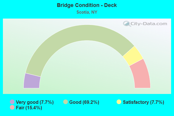
- Bridge Condition - Deck
- 7.7%Very good
- 69.2%Good
- 7.7%Satisfactory
- 15.4%Fair
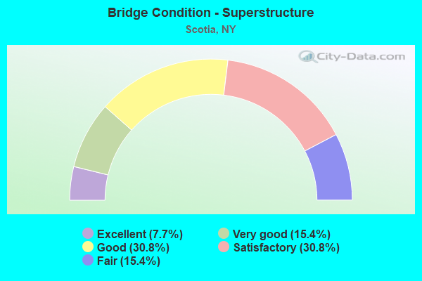
- Bridge Condition - Superstructure
- 7.7%Excellent
- 15.4%Very good
- 30.8%Good
- 30.8%Satisfactory
- 15.4%Fair
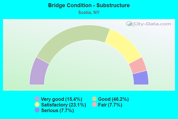
- Bridge Condition - Substructure
- 15.4%Very good
- 46.2%Good
- 23.1%Satisfactory
- 7.7%Fair
- 7.7%Serious
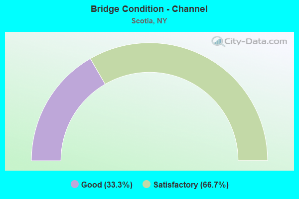
- Bridge Condition - Channel
- 33.3%Good
- 66.7%Satisfactory
Find on map >> Show street view
Structure Number: 100301, Location: .5 MI NW OF I90 EXIT 26 (Lat: 42.846053, Lng: -74.012686), Route carried "on" structure: State highway 5S, Year Built: 1939, Year Reconstructed: 1987, Status: Open, Structure Length: 1.71m (5.61ft), Average Daily Traffic: 3,664 (year 2020), Truck Traffic: 12%, Average Future Daily Traffic: 4,451 (year 2040), Design Load: HS 20, Features Intersected: PLOTTER KILL
Minimum Vertical Clearance: 30+ m (98+ ft), Kilometerpoint: 8.479, Lanes on structure: 2, Base Highway Network: Yes, Owner: State Highway Agency, Approaching Roadway Width: 9.1m (29.9ft), Skew: 1 degrees, Material/Design: Steel, Design/Construction: Stringer/Multi-beam, Number Of Spans In Main Unit: 1, Length of Maximum Span: 16.8m (55.1ft), Curb-To-Curb Width: 9.7m (31.8ft), Out-to-Out Width: 10.3m (33.8ft)
Condition: Deck: Satisfactory, Superstructure: Satisfactory, Substructure: Fair, Channel: Satisfactory, Operating Rating: 81.3 metric tons, Method Used To Determine Operating Rating: Load and Resistance Factor Rating (LRFR) rating reported by rating factor(RF) method using HL-93 loadings, Inventory Rating: 62.5 metric tons, Method Used To Determine Inventory Rating: Load and Resistance Factor Rating (LRFR) rating reported by rating factor(RF) method using HL-93 loadings, Structural Evaluation: Somewhat better than minimum adequacy, Deck Geometry: Meets minimum limits, Waterway Adequacy: Meets minimum limits, Approach Roadway Alignment: Equal to present desirable criteria, Length Of Structure Improvement: 1.70m (5.58ft), Designated Inspection Frequency: Every 24 months, Inspection Date: April 2021, Bridge Improvement Cost: $782,000, Roadway Improvement Cost: $458,000, Total Project Cost: $1,241,000 ( Estimate for 2021), Deck Structure Type: Concrete Cast-file-Place, Wearing Surface/Protective System: Wearing Surface: Integral Concrete, Deck Protection: Epoxy Coated Reinforcing
Find on map >> Show street view
Structure Number: 10263, Location: 1 MILE N JCT SH 5 & SH 50 (Lat: 42.835331, Lng: -73.955008), Route carried "on" structure: State highway 50, Year Built: 1996, Status: Open, Structure Length: 5.27m (17.29ft), Average Daily Traffic: 12,912 (year 2018), Truck Traffic: 3%, Average Future Daily Traffic: 12,972 (year 2040), Design Load: HS 25 or greater, Features Intersected: CSX TRANS/ AMTRAK
Minimum Vertical Clearance: 30+ m (98+ ft), Kilometerpoint: 1.255, Lanes on structure: 4, Base Highway Network: Yes, Owner: State Highway Agency, Approaching Roadway Width: 15.2m (49.9ft), Material/Design: Steel continuous, Design/Construction: Stringer/Multi-beam, Number Of Spans In Main Unit: 3, Length of Maximum Span: 21.3m (69.9ft), Curb or Sidewalk Widths: Left: 1.5m (4.9ft), Right: 1.5m (4.9ft), Curb-To-Curb Width: 15.1m (49.5ft), Out-to-Out Width: 18.9m (62.0ft)
Condition: Deck: Good, Superstructure: Excellent, Substructure: Good, Operating Rating: 82.6 metric tons, Method Used To Determine Operating Rating: Load Factor (LF), Inventory Rating: 44.5 metric tons, Method Used To Determine Inventory Rating: Load Factor (LF), Structural Evaluation: Better than present minimum criteria, Deck Geometry: High priority of corrective action, Underclear: Equal to present minimum criteria, Approach Roadway Alignment: Equal to present desirable criteria, Length Of Structure Improvement: 5.27m (17.29ft), Designated Inspection Frequency: Every 24 months, Inspection Date: August 2021, Bridge Improvement Cost: $2,654,000, Roadway Improvement Cost: $1,554,000, Total Project Cost: $4,208,000 ( Estimate for 2021), Deck Structure Type: Concrete Cast-file-Place, Wearing Surface/Protective System: Wearing Surface: Bituminous, Deck Protection: Epoxy Coated Reinforcing
Find on map >> Show street view
Structure Number: 109308, Location: 0.4 MI S OF END OF I890 (Lat: 42.842786, Lng: -74.006217), Route carried "on" structure: Ramp Interstate , Year Built: 1974, Year Reconstructed: 1997, Status: Open, Structure Length: 3.20m (10.50ft), Average Daily Traffic: 1,907 (year 2020), Truck Traffic: 18%, Average Future Daily Traffic: 3,022 (year 2040), Features Intersected: RTE 5S, Facility Carried by Structure: THRWY ACCESS ROAD
Minimum Vertical Clearance: 30+ m (98+ ft), Kilometerpoint: 0.306, Lanes on structure: 1, Lanes under structure: 1, Owner: State Highway Agency, Approaching Roadway Width: 10.4m (34.1ft), Skew: 4 degrees, Material/Design: Steel, Design/Construction: Stringer/Multi-beam, Number Of Spans In Main Unit: 1, Length of Maximum Span: 31.3m (102.7ft), Curb-To-Curb Width: 8.9m (29.2ft), Out-to-Out Width: 9.8m (32.2ft)
Condition: Deck: Good, Superstructure: Very good, Substructure: Good, Operating Rating: 57.0 metric tons, Method Used To Determine Operating Rating: Load and Resistance Factor Rating (LRFR) rating reported by rating factor(RF) method using HL-93 loadings, Inventory Rating: 44.1 metric tons, Method Used To Determine Inventory Rating: Load and Resistance Factor Rating (LRFR) rating reported by rating factor(RF) method using HL-93 loadings, Structural Evaluation: Better than present minimum criteria, Deck Geometry: Superior to present desirable criteria, Underclear: High priority of corrective action, Approach Roadway Alignment: Equal to present desirable criteria, Length Of Structure Improvement: 3.20m (10.50ft), Designated Inspection Frequency: Every 24 months, Inspection Date: May 2021, Bridge Improvement Cost: $1,515,000, Roadway Improvement Cost: $887,000, Total Project Cost: $2,403,000 ( Estimate for 2021), Deck Structure Type: Concrete Cast-file-Place, Wearing Surface/Protective System: Wearing Surface: Monolithic Concrete
Find on map >> Show street view
Structure Number: 1093091, Location: 0.5 MI N EXIT 26 INTRCHNG (Lat: 42.845308, Lng: -74.006472), Route carried "on" structure: State highway 890, Year Built: 1974, Year Reconstructed: 1997, Status: Open, Structure Length: 3.32m (10.89ft), Average Daily Traffic: 7,324 (year 2020), Truck Traffic: 8%, Average Future Daily Traffic: 8,486 (year 2040), Design Load: HS 25 or greater, Features Intersected: RAMP B TO RTE 5S WB (Exi
Minimum Vertical Clearance: 30+ m (98+ ft), Kilometerpoint: 0.901, Lanes on structure: 3, Lanes under structure: 1, Base Highway Network: Yes, Owner: State Highway Agency, Approaching Roadway Width: 17.1m (56.1ft), Material/Design: Steel, Design/Construction: Stringer/Multi-beam, Number Of Spans In Main Unit: 1, Length of Maximum Span: 32.0m (105.0ft), Curb-To-Curb Width: 16.3m (53.5ft), Out-to-Out Width: 17.2m (56.4ft)
Condition: Deck: Good, Superstructure: Very good, Substructure: Good, Operating Rating: 69.9 metric tons, Method Used To Determine Operating Rating: Load Factor (LF), Inventory Rating: 41.7 metric tons, Method Used To Determine Inventory Rating: Load Factor (LF), Structural Evaluation: Better than present minimum criteria, Deck Geometry: Equal to present minimum criteria, Underclear: Meets minimum limits, Approach Roadway Alignment: Equal to present desirable criteria, Length Of Structure Improvement: 3.32m (10.89ft), Designated Inspection Frequency: Every 24 months, Inspection Date: May 2020, Bridge Improvement Cost: $1,814,000, Roadway Improvement Cost: $1,062,000, Total Project Cost: $2,875,000 ( Estimate for 2021), Deck Structure Type: Concrete Cast-file-Place, Wearing Surface/Protective System: Wearing Surface: Monolithic Concrete
Find on map >> Show street view
Structure Number: 1093092, Location: 0.5 MI N EXIT 26 INTRCHNG (Lat: 42.845331, Lng: -74.006225), Route carried "on" structure: State highway 890, Year Built: 1974, Year Reconstructed: 1997, Status: Open, Structure Length: 3.32m (10.89ft), Average Daily Traffic: 7,324 (year 2020), Truck Traffic: 8%, Average Future Daily Traffic: 8,486 (year 2040), Design Load: HS 25 or greater, Features Intersected: RAMP B TO RTE 5S WB (Exi
Minimum Vertical Clearance: 30+ m (98+ ft), Kilometerpoint: 0.901, Lanes on structure: 3, Lanes under structure: 1, Base Highway Network: Yes, Owner: State Highway Agency, Approaching Roadway Width: 16.8m (55.1ft), Material/Design: Steel, Design/Construction: Stringer/Multi-beam, Number Of Spans In Main Unit: 1, Length of Maximum Span: 32.0m (105.0ft), Curb-To-Curb Width: 16.9m (55.4ft), Out-to-Out Width: 17.9m (58.7ft)
Condition: Deck: Good, Superstructure: Good, Substructure: Good, Operating Rating: 69.9 metric tons, Method Used To Determine Operating Rating: Load Factor (LF), Inventory Rating: 41.7 metric tons, Method Used To Determine Inventory Rating: Load Factor (LF), Structural Evaluation: Better than present minimum criteria, Deck Geometry: Equal to present minimum criteria, Underclear: Meets minimum limits, Approach Roadway Alignment: Equal to present desirable criteria, Length Of Structure Improvement: 3.32m (10.89ft), Designated Inspection Frequency: Every 24 months, Inspection Date: May 2020, Bridge Improvement Cost: $1,881,000, Roadway Improvement Cost: $1,101,000, Total Project Cost: $2,982,000 ( Estimate for 2021), Deck Structure Type: Concrete Cast-file-Place, Wearing Surface/Protective System: Wearing Surface: Monolithic Concrete
Find on map >> Show street view
Structure Number: 1093109, Location: .5 M S OF END OF I890 (Lat: 42.841561, Lng: -74.004403), Route carried "on" structure: Ramp Interstate 890, Year Built: 1971, Year Reconstructed: 1997, Status: Open, Structure Length: 7.32m (24.02ft), Average Daily Traffic: 3,153 (year 2018), Truck Traffic: 11%, Average Future Daily Traffic: 4,996 (year 2040), Design Load: HS 25 or greater, Features Intersected: 890I 890I 1601 1101 WB,
Minimum Vertical Clearance: 30+ m (98+ ft), Kilometerpoint: 13.306, Lanes on structure: 2, Lanes under structure: 7, Owner: State Highway Agency, Approaching Roadway Width: 16.5m (54.1ft), Skew: 30 degrees, Material/Design: Steel continuous, Design/Construction: Stringer/Multi-beam, Number Of Spans In Main Unit: 2, Length of Maximum Span: 38.1m (125.0ft), Curb-To-Curb Width: 16.7m (54.8ft), Out-to-Out Width: 18.0m (59.1ft)
Condition: Deck: Good, Superstructure: Good, Substructure: Satisfactory, Operating Rating: 71.7 metric tons, Method Used To Determine Operating Rating: Load Factor (LF), Inventory Rating: 42.6 metric tons, Method Used To Determine Inventory Rating: Load Factor (LF), Structural Evaluation: Equal to present minimum criteria, Deck Geometry: Superior to present desirable criteria, Underclear: High priority of corrective action, Approach Roadway Alignment: Equal to present minimum criteria, Length Of Structure Improvement: 7.31m (23.98ft), Designated Inspection Frequency: Every 24 months, Inspection Date: June 2021, Bridge Improvement Cost: $3,112,000, Roadway Improvement Cost: $1,823,000, Total Project Cost: $4,935,000 ( Estimate for 2021), Deck Structure Type: Concrete Cast-file-Place, Wearing Surface/Protective System: Wearing Surface: Integral Concrete, Deck Protection: Epoxy Coated Reinforcing
Find on map >> Show street view
Structure Number: 1093111, Location: 4.0 MI NW JCT I890 & 146 (Lat: 42.821103, Lng: -73.989258), Route carried "on" structure: Interstate 890, Year Built: 1974, Year Reconstructed: 1996, Status: Open, Structure Length: 2.77m (9.09ft), Average Daily Traffic: 6,581 (year 2019), Truck Traffic: 6%, Average Future Daily Traffic: 10,428 (year 2040), Design Load: HS 20, Features Intersected: SCHERMERHORN ROAD
Minimum Vertical Clearance: 30+ m (98+ ft), Kilometerpoint: 10.394, Lanes on structure: 2, Lanes under structure: 2, Base Highway Network: Yes, Owner: State Highway Agency, Approaching Roadway Width: 11.3m (37.1ft), Material/Design: Steel, Design/Construction: Stringer/Multi-beam, Number Of Spans In Main Unit: 1, Length of Maximum Span: 26.8m (87.9ft), Curb-To-Curb Width: 12.5m (41.0ft), Out-to-Out Width: 13.4m (44.0ft)
Condition: Deck: Good, Superstructure: Satisfactory, Substructure: Very good, Operating Rating: 64.4 metric tons, Method Used To Determine Operating Rating: Load Factor (LF), Inventory Rating: 38.1 metric tons, Method Used To Determine Inventory Rating: Load Factor (LF), Structural Evaluation: Equal to present minimum criteria, Deck Geometry: Better than present minimum criteria, Underclear: Somewhat better than minimum adequacy, Approach Roadway Alignment: Equal to present desirable criteria, Length Of Structure Improvement: 2.77m (9.09ft), Designated Inspection Frequency: Every 24 months, Inspection Date: April 2021, Bridge Improvement Cost: $1,243,000, Roadway Improvement Cost: $728,000, Total Project Cost: $1,971,000 ( Estimate for 2021), Deck Structure Type: Concrete Cast-file-Place, Wearing Surface/Protective System: Wearing Surface: Integral Concrete
Find on map >> Show street view
Structure Number: 1093112, Location: 4.0 MI NW JCT I890 & 146 (Lat: 42.821033, Lng: -73.989458), Route carried "on" structure: Interstate 890, Year Built: 1974, Year Reconstructed: 1996, Status: Open, Structure Length: 2.77m (9.09ft), Average Daily Traffic: 9,611 (year 2004), Truck Traffic: 9%, Design Load: HS 20, Features Intersected: SCHERMERHORN ROAD
Minimum Vertical Clearance: 30+ m (98+ ft), Kilometerpoint: 10.410, Lanes on structure: 2, Lanes under structure: 2, Base Highway Network: Yes, Owner: State Highway Agency, Approaching Roadway Width: 12.2m (40.0ft), Material/Design: Steel, Design/Construction: Stringer/Multi-beam, Number Of Spans In Main Unit: 1, Length of Maximum Span: 26.8m (87.9ft), Curb-To-Curb Width: 12.5m (41.0ft), Out-to-Out Width: 13.4m (44.0ft)
Condition: Deck: Good, Superstructure: Satisfactory, Substructure: Very good, Operating Rating: 64.4 metric tons, Method Used To Determine Operating Rating: Load Factor (LF), Inventory Rating: 38.1 metric tons, Method Used To Determine Inventory Rating: Load Factor (LF), Structural Evaluation: Equal to present minimum criteria, Deck Geometry: Better than present minimum criteria, Underclear: Somewhat better than minimum adequacy, Approach Roadway Alignment: Equal to present desirable criteria, Length Of Structure Improvement: 2.77m (9.09ft), Designated Inspection Frequency: Every 24 months, Inspection Date: April 2021, Bridge Improvement Cost: $1,243,000, Roadway Improvement Cost: $728,000, Total Project Cost: $1,971,000 ( Estimate for 2021), Deck Structure Type: Concrete Cast-file-Place, Wearing Surface/Protective System: Wearing Surface: Integral Concrete
Find on map >> Show street view
Structure Number: 225717, Location: IN VILLAGE OF SCOTIA (Lat: 42.829964, Lng: -73.948053), Route carried "on" structure: Other road , Year Built: 1976, Status: Open, Structure Length: 11.31m (37.11ft), Average Daily Traffic: 4,275 (year 2020), Truck Traffic: 3%, Average Future Daily Traffic: 5,289 (year 2040), Design Load: HS 20, Features Intersected: AMTRAK, Facility Carried by Structure: SUNNYSIDE ROAD
Minimum Vertical Clearance: 30+ m (98+ ft), Kilometerpoint: 0.949, Lanes on structure: 2, Owner: Railroad, Approaching Roadway Width: 10.7m (35.1ft), Skew: 1 degrees, Material/Design: Steel, Design/Construction: Stringer/Multi-beam, Number Of Spans In Main Unit: 5, Length of Maximum Span: 34.4m (112.9ft), Curb or Sidewalk Widths: Left: 0.0m, Right: 1.2m (3.9ft), Curb-To-Curb Width: 9.1m (29.9ft), Out-to-Out Width: 11.3m (37.1ft)
Condition: Deck: Fair, Superstructure: Fair, Substructure: Serious, Operating Rating: 50.2 metric tons, Method Used To Determine Operating Rating: Load and Resistance Factor Rating (LRFR) rating reported by rating factor(RF) method using HL-93 loadings, Inventory Rating: 38.6 metric tons, Method Used To Determine Inventory Rating: Load and Resistance Factor Rating (LRFR) rating reported by rating factor(RF) method using HL-93 loadings, Structural Evaluation: High priority of corrective action, Deck Geometry: Meets minimum limits, Underclear: Better than present minimum criteria, Approach Roadway Alignment: Better than present minimum criteria, Length Of Structure Improvement: 11.30m (37.07ft), Designated Inspection Frequency: Every 12 months, Inspection Date: August 2021, Bridge Improvement Cost: $2,623,000, Roadway Improvement Cost: $1,536,000, Total Project Cost: $4,158,000 ( Estimate for 2021), Deck Structure Type: Concrete Cast-file-Place, Wearing Surface/Protective System: Wearing Surface: Other
Find on map >> Show street view
Structure Number: 400259, Location: JCT RTE 5 & MOHAWK RIVER (Lat: 42.818808, Lng: -73.954803), Route carried "on" structure: State highway 5, Year Built: 1974, Year Reconstructed: 2014, Status: Open, Structure Length: 57.12m (187.40ft), Average Daily Traffic: 18,155 (year 2017), Truck Traffic: 4%, Average Future Daily Traffic: 18,240 (year 2040), Design Load: HS 20, Features Intersected: RAMP-SCCC PARKING, MOHAW
Minimum Vertical Clearance: 30+ m (98+ ft), Kilometerpoint: 13.709, Lanes on structure: 4, Lanes under structure: 2, Base Highway Network: Yes, Owner: State Highway Agency, Approaching Roadway Width: 15.2m (49.9ft), Skew: 1 degrees, Navigation Control: Yes ( Vertical Clearance: 6.0m (19.7ft), Horizontal Clearance: 60.9m (199.8ft)), Material/Design: Steel continuous, Design/Construction: Stringer/Multi-beam, Number Of Spans In Main Unit: 9, Length of Maximum Span: 73.2m (240.2ft), Curb or Sidewalk Widths: Left: 3.0m (9.8ft), Right: 1.7m (5.6ft), Curb-To-Curb Width: 15.2m (49.9ft), Out-to-Out Width: 20.9m (68.6ft)
Condition: Deck: Very good, Superstructure: Fair, Substructure: Good, Channel: Good, Operating Rating: 45.7 metric tons, Method Used To Determine Operating Rating: Load and Resistance Factor Rating (LRFR) rating reported by rating factor(RF) method using HL-93 loadings, Inventory Rating: 35.3 metric tons, Method Used To Determine Inventory Rating: Load and Resistance Factor Rating (LRFR) rating reported by rating factor(RF) method using HL-93 loadings, Structural Evaluation: Somewhat better than minimum adequacy, Deck Geometry: High priority of corrective action, Underclear: High priority of corrective action, Waterway Adequacy: Equal to present minimum criteria, Approach Roadway Alignment: Equal to present desirable criteria, Length Of Structure Improvement: 57.11m (187.37ft), Designated Inspection Frequency: Every 24 months, Underwater Inspection Frequency: Every 60 months, Inspection Date: September 2020, Underwater Inspection Date: October 2021, Bridge Improvement Cost: $23,302,000, Roadway Improvement Cost: $13,646,000, Total Project Cost: $36,947,000 ( Estimate for 2021), Deck Structure Type: Concrete Cast-file-Place, Wearing Surface/Protective System: Wearing Surface: Integral Concrete, Deck Protection: Epoxy Coated Reinforcing
Find on map >> Show street view
Structure Number: 443729, Location: 0.6 MI N THRUWAY-EXIT 26 (Lat: 42.848992, Lng: -74.005847), Route carried "on" structure: State highway 890, Year Built: 1998, Status: Open, Structure Length: 25.97m (85.20ft), Average Daily Traffic: 14,647 (year 2020), Truck Traffic: 8%, Average Future Daily Traffic: 16,972 (year 2040), Design Load: HS 25 or greater, Features Intersected: MOHAWK R/ERIE CNL, BIKE
Minimum Vertical Clearance: 30+ m (98+ ft), Kilometerpoint: 1.303, Lanes on structure: 4, Base Highway Network: Yes, Owner: State Highway Agency, Approaching Roadway Width: 20.7m (67.9ft), Skew: 20 degrees, Navigation Control: Yes ( Vertical Clearance: 6.4m (21.0ft), Horizontal Clearance: 60.9m (199.8ft)), Material/Design: Steel continuous, Design/Construction: Stringer/Multi-beam, Number Of Spans In Main Unit: 4, Length of Maximum Span: 76.2m (250.0ft), Curb or Sidewalk Widths: Left: 3.6m (11.8ft), Right: 0.0m, Curb-To-Curb Width: 20.7m (67.9ft), Out-to-Out Width: 26.2m (86.0ft)
Condition: Deck: Fair, Superstructure: Good, Substructure: Good, Channel: Satisfactory, Operating Rating: 75.3 metric tons, Method Used To Determine Operating Rating: Load Factor (LF), Inventory Rating: 45.4 metric tons, Method Used To Determine Inventory Rating: Load Factor (LF), Structural Evaluation: Better than present minimum criteria, Deck Geometry: Equal to present minimum criteria, Waterway Adequacy: Equal to present minimum criteria, Approach Roadway Alignment: Equal to present desirable criteria, Length Of Structure Improvement: 25.96m (85.17ft), Designated Inspection Frequency: Every 24 months, Underwater Inspection Frequency: Every 60 months, Inspection Date: September 2020, Underwater Inspection Date: July 2021, Bridge Improvement Cost: $13,821,000, Roadway Improvement Cost: $8,093,000, Total Project Cost: $21,914,000 ( Estimate for 2021), Deck Structure Type: Concrete Cast-file-Place, Wearing Surface/Protective System: Wearing Surface: Integral Concrete, Deck Protection: Epoxy Coated Reinforcing
Find on map >> Show street view
Structure Number: 5203039, Location: 1.1 MI NW INT 26 ON I90 (Lat: 42.850081, Lng: -74.026639), Route carried "on" structure: Interstate 90, Year Built: 1955, Year Reconstructed: 1987, Status: Open, Structure Length: 1.19m (3.90ft), Average Daily Traffic: 22,249 (year 2020), Truck Traffic: 31%, Average Future Daily Traffic: 35,257 (year 2040), Design Load: HS 20, Features Intersected: GREGG ROAD
Minimum Vertical Clearance: 30+ m (98+ ft), Kilometerpoint: 7.273, Lanes on structure: 4, Lanes under structure: 2, Base Highway Network: Yes, Toll: On Interstate toll segment, Owner: State Toll Authority, Approaching Roadway Width: 33.8m (110.9ft), Skew: 33 degrees, Material/Design: Concrete, Design/Construction: Slab, Number Of Spans In Main Unit: 1, Length of Maximum Span: 11.3m (37.1ft), Curb-To-Curb Width: 33.6m (110.2ft), Out-to-Out Width: 34.4m (112.9ft)
Condition: Deck: Good, Superstructure: Good, Substructure: Satisfactory, Operating Rating: 58.1 metric tons, Method Used To Determine Operating Rating: Load Factor (LF), Inventory Rating: 19.1 metric tons, Method Used To Determine Inventory Rating: Load Factor (LF), Structural Evaluation: Meets minimum limits, Deck Geometry: Superior to present desirable criteria, Underclear: Meets minimum limits, Approach Roadway Alignment: Equal to present desirable criteria, Length Of Structure Improvement: 1.18m (3.87ft), Designated Inspection Frequency: Every 24 months, Inspection Date: September 2021, Bridge Improvement Cost: $3,720,000, Roadway Improvement Cost: $2,178,000, Total Project Cost: $5,898,000 ( Estimate for 2021), Wearing Surface/Protective System: Wearing Surface: Bituminous, Membrane: Preformed Fabric
Find on map >> Show street view
Structure Number: 5513749, Location: I90 INT 26 (Lat: 42.838200, Lng: -74.012775), Route carried "on" structure: Interstate 90, Year Built: 1955, Year Reconstructed: 1988, Status: Open, Structure Length: 1.80m (5.91ft), Average Daily Traffic: 22,249 (year 2020), Truck Traffic: 31%, Average Future Daily Traffic: 35,257 (year 2040), Design Load: HS 20+Mod, Features Intersected: INTERCHANGE 26
Minimum Vertical Clearance: 30+ m (98+ ft), Kilometerpoint: 9.010, Lanes on structure: 5, Lanes under structure: 2, Base Highway Network: Yes, Toll: On Interstate toll segment, Owner: State Toll Authority, Approaching Roadway Width: 37.8m (124.0ft), Skew: 32 degrees, Material/Design: Steel, Design/Construction: Stringer/Multi-beam, Number Of Spans In Main Unit: 1, Length of Maximum Span: 16.2m (53.1ft), Curb-To-Curb Width: 37.4m (122.7ft), Out-to-Out Width: 38.1m (125.0ft)
Condition: Deck: Good, Superstructure: Satisfactory, Substructure: Satisfactory, Operating Rating: 70.8 metric tons, Method Used To Determine Operating Rating: Load Factor (LF), Inventory Rating: 39.9 metric tons, Method Used To Determine Inventory Rating: Load Factor (LF), Structural Evaluation: Equal to present minimum criteria, Deck Geometry: Superior to present desirable criteria, Underclear: High priority of corrective action, Approach Roadway Alignment: Equal to present desirable criteria, Length Of Structure Improvement: 1.79m (5.87ft), Designated Inspection Frequency: Every 24 months, Inspection Date: July 2021, Bridge Improvement Cost: $3,746,000, Roadway Improvement Cost: $2,194,000, Total Project Cost: $5,940,000 ( Estimate for 2021), Deck Structure Type: Concrete Cast-file-Place, Wearing Surface/Protective System: Wearing Surface: Bituminous, Membrane: Other, Deck Protection: Epoxy Coated Reinforcing
Find on map >> Show street view
Structure Number: 109308, Location: 0.4 MI S OF END OF I890 (Lat: 42.842786, Lng: -74.006217), Route carried "under" structure: State highway 5S, Year Built: 1974, Structure Length: 0. m, Average Daily Traffic: 10,802 (year 1998), Features Intersected: RTE 5S, Facility Carried by Structure: THRWY ACCESS ROAD
Minimum Vertical Clearance: 5.49m (18.01ft), Kilometerpoint: 8.850, Lanes on structure: 1, Lanes under structure: 1, Material/Design: Steel, Design/Construction: Stringer/Multi-beam, Length of Maximum Span: 31.3m (102.7ft)
Find on map >> Show street view
Structure Number: 1093091, Location: 0.5 MI N EXIT 26 INTRCHNG (Lat: 42.845308, Lng: -74.006472), Route carried "under" structure: Ramp Other road , Year Built: 1974, Structure Length: 0. m, Average Daily Traffic: 6,000 (year 2021), Features Intersected: RAMP B TO RTE 5S WB (Exi, Facility Carried by Structure: RTE 890
Minimum Vertical Clearance: 5.74m (18.83ft), Kilometerpoint: 0.000, Lanes on structure: 3, Lanes under structure: 1, Material/Design: Steel, Design/Construction: Stringer/Multi-beam, Length of Maximum Span: 32.0m (105.0ft)
Find on map >> Show street view
Structure Number: 1093092, Location: 0.5 MI N EXIT 26 INTRCHNG (Lat: 42.845331, Lng: -74.006225), Route carried "under" structure: Ramp Other road , Year Built: 1974, Structure Length: 0. m, Average Daily Traffic: 6,000 (year 2021), Features Intersected: RAMP B TO RTE 5S WB (Exi, Facility Carried by Structure: RTE 890
Minimum Vertical Clearance: 5.26m (17.26ft), Kilometerpoint: 0.000, Lanes on structure: 3, Lanes under structure: 1, Material/Design: Steel, Design/Construction: Stringer/Multi-beam, Length of Maximum Span: 32.0m (105.0ft)
Find on map >> Show street view
Structure Number: 1093109, Location: .5 M S OF END OF I890 (Lat: 42.841561, Lng: -74.004403), Route carried "under" structure: Interstate 890, Year Built: 1971, Structure Length: 0. m, Average Daily Traffic: 13,500 (year 1992), Features Intersected: 890I 890I 1601 1101 WB,
Minimum Vertical Clearance: 7.34m (24.08ft), Kilometerpoint: 9.702, Lanes on structure: 2, Lanes under structure: 4, Material/Design: Steel continuous, Design/Construction: Stringer/Multi-beam, Length of Maximum Span: 38.1m (125.0ft)
Find on map >> Show street view
Structure Number: 1093111, Location: 4.0 MI NW JCT I890 & 146 (Lat: 42.821103, Lng: -73.989258), Route carried "under" structure: Spur County highway , Year Built: 1974, Structure Length: 0. m, Average Daily Traffic: 86 (year 2017), Truck Traffic: 10%, Features Intersected: SCHERMERHORN ROAD, Facility Carried by Structure: RTE I890
Minimum Vertical Clearance: 4.62m (15.16ft), Kilometerpoint: 1.464, Lanes on structure: 2, Lanes under structure: 2, Material/Design: Steel, Design/Construction: Stringer/Multi-beam, Length of Maximum Span: 26.8m (87.9ft)
Find on map >> Show street view
Structure Number: 1093112, Location: 4.0 MI NW JCT I890 & 146 (Lat: 42.821033, Lng: -73.989458), Route carried "under" structure: Spur County highway , Year Built: 1974, Structure Length: 0. m, Average Daily Traffic: 86 (year 2017), Truck Traffic: 10%, Features Intersected: SCHERMERHORN ROAD, Facility Carried by Structure: RTE I890
Minimum Vertical Clearance: 4.60m (15.09ft), Kilometerpoint: 1.448, Lanes on structure: 2, Lanes under structure: 2, Material/Design: Steel, Design/Construction: Stringer/Multi-beam, Length of Maximum Span: 26.8m (87.9ft)
Find on map >> Show street view
Structure Number: 400259, Location: JCT RTE 5 & MOHAWK RIVER (Lat: 42.818808, Lng: -73.954803), Route carried "under" structure: Ramp Other road , Year Built: 1974, Structure Length: 0. m, Average Daily Traffic: 1,000 (year 2021), Features Intersected: RAMP-SCCC PARKING, MOHAW, Facility Carried by Structure: RTE 5
Minimum Vertical Clearance: 4.75m (15.58ft), Kilometerpoint: 0.000, Lanes on structure: 4, Lanes under structure: 2, Material/Design: Steel continuous, Design/Construction: Stringer/Multi-beam, Length of Maximum Span: 73.2m (240.2ft)
Find on map >> Show street view
Structure Number: 5203039, Location: 1.1 MI NW INT 26 ON I90 (Lat: 42.850081, Lng: -74.026639), Route carried "under" structure: Other road , Year Built: 1955, Structure Length: 0. m, Truck Traffic: 7%, Features Intersected: GREGG ROAD, Facility Carried by Structure: RTE I90
Minimum Vertical Clearance: 4.60m (15.09ft), Kilometerpoint: 0.000, Lanes on structure: 4, Lanes under structure: 2, Material/Design: Concrete, Design/Construction: Slab, Length of Maximum Span: 11.3m (37.1ft)
Find on map >> Show street view
Structure Number: 5513749, Location: I90 INT 26 (Lat: 42.838200, Lng: -74.012775), Route carried "under" structure: Ramp Other road , Year Built: 1955, Structure Length: 0. m, Average Daily Traffic: 1,008 (year 1978), Features Intersected: INTERCHANGE 26, Facility Carried by Structure: RTE I90
Minimum Vertical Clearance: 4.52m (14.83ft), Kilometerpoint: 0.000, Lanes on structure: 5, Lanes under structure: 2, Toll: On Interstate toll segment, Material/Design: Steel, Design/Construction: Stringer/Multi-beam, Length of Maximum Span: 16.2m (53.1ft)
Find on map >> Show street view
Structure Number: 702629, Location: JCT SPRINGFLD TRM & SH 50 (Lat: 42.834097, Lng: -73.955883), Route carried "under" structure: State highway 50, Year Built: 1949, Structure Length: 0. m, Average Daily Traffic: 13,336 (year 1999), Features Intersected: RTE 50, Facility Carried by Structure: SPRINGFIELD TERML
Minimum Vertical Clearance: 4.34m (14.24ft), Kilometerpoint: 1.126, Lanes under structure: 2, Material/Design: Steel, Design/Construction: Box Beam or Girders - Single/Spread, Length of Maximum Span: 34.1m (111.9ft)
Find on map >> Show street view
Structure Number: 7513731, Location: EXIT 26 OF I90 (Lat: 42.839594, Lng: -74.008142), Route carried "under" structure: Ramp Interstate , Year Built: 1955, Structure Length: 0. m, Average Daily Traffic: 7,053 (year 2014), Features Intersected: INTERCHANGE 26, Facility Carried by Structure: CSX TRANSPORT
Minimum Vertical Clearance: 4.88m (16.01ft), Kilometerpoint: 260.980, Lanes under structure: 2, Material/Design: Steel, Design/Construction: Stringer/Multi-beam, Length of Maximum Span: 18.9m (62.0ft)
Find on map >> Show street view
Structure Number: 7513732, Location: EXIT 26 OF I90 (Lat: 42.839678, Lng: -74.008094), Route carried "under" structure: Ramp Interstate , Year Built: 1955, Structure Length: 0. m, Average Daily Traffic: 7,053 (year 2014), Features Intersected: INTERCHANGE 26, Facility Carried by Structure: CSX TRANSPORT
Minimum Vertical Clearance: 4.65m (15.26ft), Kilometerpoint: 260.964, Lanes under structure: 2, Material/Design: Steel, Design/Construction: Stringer/Multi-beam, Length of Maximum Span: 18.9m (62.0ft)