Bridge Statistics for Schenectady, New York (NY)
Condition, Traffic, Stress, Structural Evaluation, Project Costs
- National Bridge Inventory (NBI) Statistics
- 53Number of bridges
- 935ft / 285mTotal length
- $153,141,000Total costs
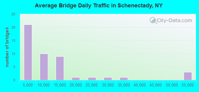
- 490,817Total average daily traffic
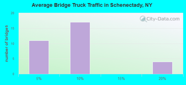
- 14,989Total average daily truck traffic
- National Bridge Inventory (NBI) Registered Bridges for Schenectady
- No street view available for this location
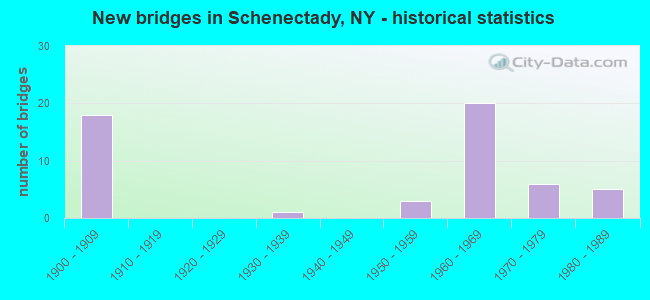
- New bridges - historical statistics
- 181900-1909
- 11930-1939
- 31950-1959
- 201960-1969
- 61970-1979
- 51980-1989
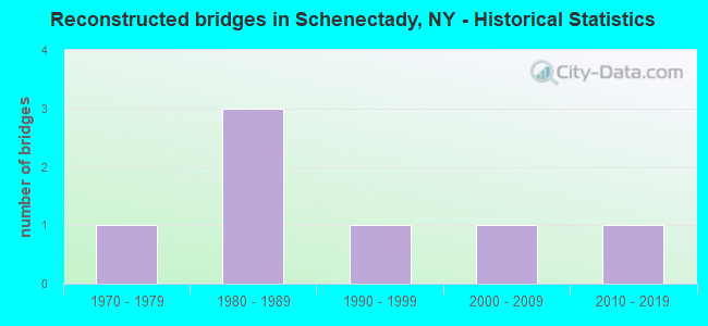
- Reconstructed bridges - Historical Statistics
- 11970-1979
- 31980-1989
- 11990-1999
- 12000-2009
- 12010-2019
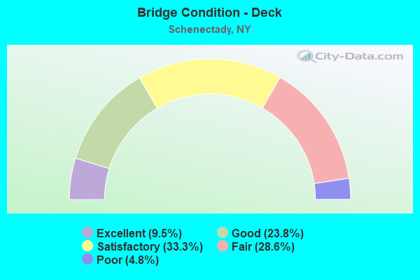
- Bridge Condition - Deck
- 9.5%Excellent
- 23.8%Good
- 33.3%Satisfactory
- 28.6%Fair
- 4.8%Poor
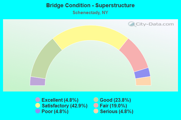
- Bridge Condition - Superstructure
- 4.8%Excellent
- 23.8%Good
- 42.9%Satisfactory
- 19.0%Fair
- 4.8%Poor
- 4.8%Serious
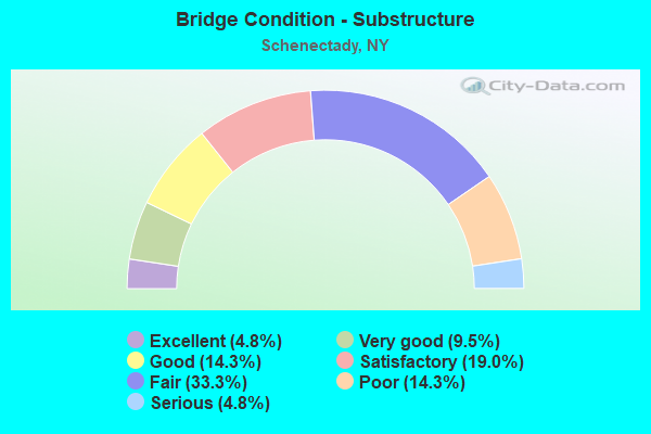
- Bridge Condition - Substructure
- 4.8%Excellent
- 9.5%Very good
- 14.3%Good
- 19.0%Satisfactory
- 33.3%Fair
- 14.3%Poor
- 4.8%Serious
Find on map >> Show street view
Structure Number: 100261, Location: JCT SH 5 & SH 7 (Lat: 42.785433, Lng: -73.909669), Route carried "on" structure: State highway 5, Year Built: 1958, Year Reconstructed: 2014, Status: Open, Structure Length: 2.26m (7.41ft), Average Daily Traffic: 8,601 (year 2017), Truck Traffic: 6%, Average Future Daily Traffic: 8,641 (year 2040), Design Load: HS 20, Features Intersected: RTE 7
Minimum Vertical Clearance: 30+ m (98+ ft), Kilometerpoint: 19.501, Lanes on structure: 4, Lanes under structure: 4, Base Highway Network: Yes, Owner: State Highway Agency, Approaching Roadway Width: 16.5m (54.1ft), Material/Design: Steel, Design/Construction: Stringer/Multi-beam, Number Of Spans In Main Unit: 1, Length of Maximum Span: 21.0m (68.9ft), Curb or Sidewalk Widths: Left: 2.9m (9.5ft), Right: 2.9m (9.5ft), Curb-To-Curb Width: 16.5m (54.1ft), Out-to-Out Width: 23.3m (76.4ft)
Condition: Deck: Excellent, Superstructure: Satisfactory, Substructure: Fair, Operating Rating: 78.9 metric tons, Method Used To Determine Operating Rating: Load Factor (LF), Inventory Rating: 47.2 metric tons, Method Used To Determine Inventory Rating: Load Factor (LF), Structural Evaluation: Somewhat better than minimum adequacy, Deck Geometry: Meets minimum limits, Underclear: High priority of corrective action, Approach Roadway Alignment: Equal to present desirable criteria, Length Of Structure Improvement: 2.25m (7.38ft), Designated Inspection Frequency: Every 24 months, Inspection Date: September 2020, Bridge Improvement Cost: $2,140,000, Roadway Improvement Cost: $1,253,000, Total Project Cost: $3,394,000 ( Estimate for 2021), Deck Structure Type: Concrete Cast-file-Place, Wearing Surface/Protective System: Wearing Surface: Integral Concrete, Deck Protection: Epoxy Coated Reinforcing
Find on map >> Show street view
Structure Number: 103834, Location: JCT RTES 146 & I890 (Lat: 42.796011, Lng: -73.928564), Route carried "on" structure: State highway 146, Year Built: 1962, Year Reconstructed: 1992, Status: Open, Structure Length: 5.94m (19.49ft), Average Daily Traffic: 6,994 (year 2018), Truck Traffic: 3%, Average Future Daily Traffic: 7,026 (year 2040), Features Intersected: 890I 890I 1601 2018 WB,
Minimum Vertical Clearance: 30+ m (98+ ft), Kilometerpoint: 4.264, Lanes on structure: 2, Lanes under structure: 7, Base Highway Network: Yes, Owner: State Highway Agency, Approaching Roadway Width: 10.1m (33.1ft), Skew: 1 degrees, Material/Design: Steel, Design/Construction: Stringer/Multi-beam, Number Of Spans In Main Unit: 4, Length of Maximum Span: 20.7m (67.9ft), Curb or Sidewalk Widths: Left: 1.5m (4.9ft), Right: 1.5m (4.9ft), Curb-To-Curb Width: 10.1m (33.1ft), Out-to-Out Width: 13.7m (44.9ft)
Condition: Deck: Satisfactory, Superstructure: Satisfactory, Substructure: Good, Operating Rating: 50.8 metric tons, Method Used To Determine Operating Rating: Load Factor (LF), Inventory Rating: 29.9 metric tons, Method Used To Determine Inventory Rating: Load Factor (LF), Structural Evaluation: Equal to present minimum criteria, Deck Geometry: Meets minimum limits, Underclear: High priority of corrective action, Approach Roadway Alignment: Equal to present desirable criteria, Length Of Structure Improvement: 5.94m (19.49ft), Designated Inspection Frequency: Every 24 months, Inspection Date: June 2021, Bridge Improvement Cost: $1,720,000, Roadway Improvement Cost: $1,007,000, Total Project Cost: $2,728,000 ( Estimate for 2021), Deck Structure Type: Concrete Cast-file-Place, Wearing Surface/Protective System: Wearing Surface: Integral Concrete
Find on map >> Show street view
Structure Number: 104991, Location: 1.4 MI S JCT SH 5 & SH 50 (Lat: 42.812808, Lng: -73.950097), Route carried "on" structure: Ramp Interstate 890, Year Built: 1965, Status: Open, Structure Length: 5.43m (17.81ft), Average Daily Traffic: 8,757 (year 2017), Truck Traffic: 18%, Average Future Daily Traffic: 13,877 (year 2040), Design Load: HS 20+Mod, Features Intersected: BIG CIRCLE, WASHINGTON A
Minimum Vertical Clearance: 30+ m (98+ ft), Kilometerpoint: 0.451, Lanes on structure: 3, Lanes under structure: 5, Owner: State Highway Agency, Approaching Roadway Width: 12.2m (40.0ft), Material/Design: Steel, Design/Construction: Stringer/Multi-beam, Number Of Spans In Main Unit: 3, Length of Maximum Span: 21.3m (69.9ft), Curb or Sidewalk Widths: Left: 0.8m (2.6ft), Right: 0.8m (2.6ft), Curb-To-Curb Width: 12.2m (40.0ft), Out-to-Out Width: 13.8m (45.3ft)
Condition: Deck: Satisfactory, Superstructure: Satisfactory, Substructure: Fair, Operating Rating: 75.2 metric tons, Method Used To Determine Operating Rating: Load and Resistance Factor Rating (LRFR) rating reported by rating factor(RF) method using HL-93 loadings, Inventory Rating: 58.0 metric tons, Method Used To Determine Inventory Rating: Load and Resistance Factor Rating (LRFR) rating reported by rating factor(RF) method using HL-93 loadings, Structural Evaluation: Somewhat better than minimum adequacy, Deck Geometry: High priority of corrective action, Underclear: High priority of corrective action, Approach Roadway Alignment: Equal to present desirable criteria, Length Of Structure Improvement: 5.42m (17.78ft), Designated Inspection Frequency: Every 24 months, Inspection Date: September 2020, Bridge Improvement Cost: $1,639,000, Roadway Improvement Cost: $960,000, Total Project Cost: $2,598,000 ( Estimate for 2021), Deck Structure Type: Concrete Cast-file-Place, Wearing Surface/Protective System: Wearing Surface: Integral Concrete
Find on map >> Show street view
Structure Number: 1049921, Location: 1.6 MI NW JCT SH146 &I890 (Lat: 42.805053, Lng: -73.948028), Route carried "on" structure: Interstate 890, Year Built: 1966, Status: Open, Structure Length: 80.16m (262.99ft), Average Daily Traffic: 6,510 (year 2019), Truck Traffic: 18%, Average Future Daily Traffic: 10,315 (year 2040), Design Load: HS 20, Features Intersected: Washington Ave Ramp, AMT
Minimum Vertical Clearance: 30+ m (98+ ft), Kilometerpoint: 5.953, Lanes on structure: 3, Lanes under structure: 16, Base Highway Network: Yes, Owner: State Highway Agency, Approaching Roadway Width: 11.9m (39.0ft), Skew: 2 degrees, Material/Design: Steel, Design/Construction: Stringer/Multi-beam, Number Of Spans In Main Unit: 29, Length of Maximum Span: 48.1m (157.8ft), Curb-To-Curb Width: 11.9m (39.0ft), Out-to-Out Width: 16.2m (53.1ft)
Condition: Deck: Good, Superstructure: Satisfactory, Substructure: Fair, Operating Rating: 59.9 metric tons, Method Used To Determine Operating Rating: Load Factor (LF), Inventory Rating: 35.4 metric tons, Method Used To Determine Inventory Rating: Load Factor (LF), Structural Evaluation: Somewhat better than minimum adequacy, Deck Geometry: High priority of replacement, Underclear: High priority of corrective action, Approach Roadway Alignment: Equal to present desirable criteria, Length Of Structure Improvement: 80.16m (262.99ft), Designated Inspection Frequency: Every 24 months, Inspection Date: December 2020, Bridge Improvement Cost: $25,876,000, Roadway Improvement Cost: $15,153,000, Total Project Cost: $41,028,000 ( Estimate for 2021), Deck Structure Type: Concrete Cast-file-Place, Wearing Surface/Protective System: Wearing Surface: Integral Concrete
Find on map >> Show street view
Structure Number: 1049922, Location: 1.6MI NW JCT. 146 & 890I (Lat: 42.805017, Lng: -73.948208), Route carried "on" structure: Interstate 890, Year Built: 1966, Status: Open, Structure Length: 80.16m (262.99ft), Average Daily Traffic: 23,418 (year 2004), Truck Traffic: 9%, Average Future Daily Traffic: 32,785 (year 2024), Design Load: HS 20, Features Intersected: Washington Ave Ramp, Amt
Minimum Vertical Clearance: 30+ m (98+ ft), Kilometerpoint: 5.937, Lanes on structure: 3, Lanes under structure: 14, Base Highway Network: Yes, Owner: State Highway Agency, Approaching Roadway Width: 11.9m (39.0ft), Material/Design: Steel, Design/Construction: Stringer/Multi-beam, Number Of Spans In Main Unit: 30, Length of Maximum Span: 42.6m (139.8ft), Curb-To-Curb Width: 11.9m (39.0ft), Out-to-Out Width: 16.7m (54.8ft)
Condition: Deck: Satisfactory, Superstructure: Good, Substructure: Poor, Operating Rating: 45.4 metric tons, Method Used To Determine Operating Rating: Load Factor (LF), Inventory Rating: 27.2 metric tons, Method Used To Determine Inventory Rating: Load Factor (LF), Structural Evaluation: Meets minimum limits, Deck Geometry: High priority of replacement, Underclear: High priority of corrective action, Approach Roadway Alignment: Equal to present desirable criteria, Length Of Structure Improvement: 80.16m (262.99ft), Designated Inspection Frequency: Every 24 months, Inspection Date: December 2020, Bridge Improvement Cost: $26,605,000, Roadway Improvement Cost: $15,580,000, Total Project Cost: $42,186,000 ( Estimate for 2021), Deck Structure Type: Concrete Cast-file-Place, Wearing Surface/Protective System: Wearing Surface: Integral Concrete
Find on map >> Show street view
Structure Number: 104992A, Location: 1.6 MI NW JCT SH146& I890 (Lat: 42.807075, Lng: -73.949161), Route carried "on" structure: Interstate , Year Built: 1966, Status: Open, Structure Length: 14.97m (49.11ft), Average Daily Traffic: 1,860 (year 2018), Truck Traffic: 18%, Average Future Daily Traffic: 2,947 (year 2040), Design Load: H 20, Features Intersected: VACANT LAND, Facility Carried by Structure: ON-RAMP OF I890
Minimum Vertical Clearance: 30+ m (98+ ft), Kilometerpoint: 0.080, Lanes on structure: 1, Owner: State Highway Agency, Approaching Roadway Width: 6.7m (22.0ft), Skew: 2 degrees, Material/Design: Steel, Design/Construction: Stringer/Multi-beam, Number Of Spans In Main Unit: 8, Length of Maximum Span: 24.7m (81.0ft), Curb-To-Curb Width: 6.7m (22.0ft), Out-to-Out Width: 8.3m (27.2ft)
Condition: Deck: Good, Superstructure: Good, Substructure: Fair, Operating Rating: 55.3 metric tons, Method Used To Determine Operating Rating: Load Factor (LF), Inventory Rating: 33.6 metric tons, Method Used To Determine Inventory Rating: Load Factor (LF), Structural Evaluation: Somewhat better than minimum adequacy, Deck Geometry: High priority of corrective action, Approach Roadway Alignment: Better than present minimum criteria, Length Of Structure Improvement: 14.96m (49.08ft), Designated Inspection Frequency: Every 24 months, Inspection Date: October 2020, Bridge Improvement Cost: $2,503,000, Roadway Improvement Cost: $1,466,000, Total Project Cost: $3,968,000 ( Estimate for 2021), Deck Structure Type: Concrete Cast-file-Place, Wearing Surface/Protective System: Wearing Surface: Integral Concrete
Find on map >> Show street view
Structure Number: 104992B, Location: 1.6 MI NW JCT SH146& I890 (Lat: 42.806686, Lng: -73.949506), Route carried "on" structure: Interstate , Year Built: 1966, Status: Open, Structure Length: 16.82m (55.18ft), Average Daily Traffic: 2,030 (year 2018), Truck Traffic: 18%, Average Future Daily Traffic: 3,216 (year 2040), Design Load: H 20, Features Intersected: NORFOLK SOUTHERN, Facility Carried by Structure: OFF-RAMP OF I890
Minimum Vertical Clearance: 30+ m (98+ ft), Kilometerpoint: 0.016, Lanes on structure: 1, Owner: State Highway Agency, Approaching Roadway Width: 6.7m (22.0ft), Skew: 1 degrees, Material/Design: Steel, Design/Construction: Stringer/Multi-beam, Number Of Spans In Main Unit: 8, Length of Maximum Span: 25.9m (85.0ft), Curb-To-Curb Width: 6.7m (22.0ft), Out-to-Out Width: 8.3m (27.2ft)
Condition: Deck: Good, Superstructure: Good, Substructure: Satisfactory, Operating Rating: 65.3 metric tons, Method Used To Determine Operating Rating: Load Factor (LF), Inventory Rating: 39.0 metric tons, Method Used To Determine Inventory Rating: Load Factor (LF), Structural Evaluation: Equal to present minimum criteria, Deck Geometry: High priority of replacement, Underclear: Superior to present desirable criteria, Approach Roadway Alignment: Better than present minimum criteria, Length Of Structure Improvement: 16.82m (55.18ft), Designated Inspection Frequency: Every 24 months, Inspection Date: October 2020, Bridge Improvement Cost: $2,817,000, Roadway Improvement Cost: $1,650,000, Total Project Cost: $4,467,000 ( Estimate for 2021), Deck Structure Type: Concrete Cast-file-Place, Wearing Surface/Protective System: Wearing Surface: Integral Concrete
Find on map >> Show street view
Structure Number: 1049939, Location: 2.3 MI NW JCT I890 & 146 (Lat: 42.814497, Lng: -73.961106), Route carried "on" structure: Bypass Interstate 890, Year Built: 1966, Year Reconstructed: 1996, Status: Open, Structure Length: 4.21m (13.81ft), Average Daily Traffic: 14,643 (year 2019), Truck Traffic: 5%, Average Future Daily Traffic: 23,204 (year 2040), Design Load: HS 20+Mod, Features Intersected: RAMP F STRUCT B
Minimum Vertical Clearance: 30+ m (98+ ft), Kilometerpoint: 7.675, Lanes on structure: 8, Lanes under structure: 1, Base Highway Network: Yes, Owner: State Highway Agency, Approaching Roadway Width: 31.1m (102.0ft), Skew: 20 degrees, Material/Design: Steel, Design/Construction: Stringer/Multi-beam, Number Of Spans In Main Unit: 3, Length of Maximum Span: 16.7m (54.8ft), Curb-To-Curb Width: 31.1m (102.0ft), Out-to-Out Width: 35.1m (115.2ft)
Condition: Deck: Satisfactory, Superstructure: Satisfactory, Substructure: Fair, Operating Rating: 76.2 metric tons, Method Used To Determine Operating Rating: Load Factor (LF), Inventory Rating: 45.4 metric tons, Method Used To Determine Inventory Rating: Load Factor (LF), Structural Evaluation: Somewhat better than minimum adequacy, Deck Geometry: Meets minimum limits, Underclear: Somewhat better than minimum adequacy, Approach Roadway Alignment: Equal to present desirable criteria, Length Of Structure Improvement: 4.20m (13.78ft), Designated Inspection Frequency: Every 24 months, Inspection Date: August 2020, Bridge Improvement Cost: $3,354,000, Roadway Improvement Cost: $1,964,000, Total Project Cost: $5,318,000 ( Estimate for 2021), Deck Structure Type: Concrete Cast-file-Place, Wearing Surface/Protective System: Wearing Surface: Integral Concrete
Find on map >> Show street view
Structure Number: 1049949, Location: 2.0 MI NW JCT I890 & 146 (Lat: 42.814264, Lng: -73.956431), Route carried "on" structure: Bypass Interstate 890, Year Built: 1966, Status: Open, Structure Length: 4.79m (15.72ft), Average Daily Traffic: 14,643 (year 2019), Truck Traffic: 5%, Average Future Daily Traffic: 23,204 (year 2040), Design Load: HS 20+Mod, Features Intersected: BIG CIRCLE
Minimum Vertical Clearance: 30+ m (98+ ft), Kilometerpoint: 7.273, Lanes on structure: 5, Lanes under structure: 3, Base Highway Network: Yes, Owner: State Highway Agency, Approaching Roadway Width: 21.9m (71.9ft), Skew: 21 degrees, Material/Design: Steel, Design/Construction: Stringer/Multi-beam, Number Of Spans In Main Unit: 3, Length of Maximum Span: 23.2m (76.1ft), Curb-To-Curb Width: 22.3m (73.2ft), Out-to-Out Width: 24.2m (79.4ft)
Condition: Deck: Good, Superstructure: Fair, Substructure: Poor, Operating Rating: 57.2 metric tons, Method Used To Determine Operating Rating: Load Factor (LF), Inventory Rating: 34.5 metric tons, Method Used To Determine Inventory Rating: Load Factor (LF), Structural Evaluation: Meets minimum limits, Deck Geometry: Meets minimum limits, Underclear: High priority of corrective action, Approach Roadway Alignment: Equal to present desirable criteria, Length Of Structure Improvement: 4.78m (15.68ft), Designated Inspection Frequency: Every 24 months, Inspection Date: September 2021, Bridge Improvement Cost: $2,609,000, Roadway Improvement Cost: $1,528,000, Total Project Cost: $4,136,000 ( Estimate for 2021), Deck Structure Type: Concrete Cast-file-Place, Wearing Surface/Protective System: Wearing Surface: Integral Concrete
Find on map >> Show street view
Structure Number: 104996, Location: 0.65 MI NW JCT 146 & I890 (Lat: 42.800394, Lng: -73.939472), Route carried "on" structure: City street , Year Built: 1965, Status: Open, Structure Length: 7.01m (23.00ft), Average Daily Traffic: 3,016 (year 2017), Truck Traffic: 5%, Average Future Daily Traffic: 3,731 (year 2040), Features Intersected: 890 I890I 1601 2012 WB,, Facility Carried by Structure: CRAIG STREET
Minimum Vertical Clearance: 30+ m (98+ ft), Kilometerpoint: 0.724, Lanes on structure: 2, Lanes under structure: 6, Owner: State Highway Agency, Approaching Roadway Width: 12.8m (42.0ft), Skew: 1 degrees, Material/Design: Steel, Design/Construction: Stringer/Multi-beam, Number Of Spans In Main Unit: 4, Length of Maximum Span: 17.0m (55.8ft), Curb or Sidewalk Widths: Left: 1.5m (4.9ft), Right: 1.5m (4.9ft), Curb-To-Curb Width: 12.8m (42.0ft), Out-to-Out Width: 16.5m (54.1ft)
Condition: Deck: Satisfactory, Superstructure: Satisfactory, Substructure: Very good, Operating Rating: 61.6 metric tons, Method Used To Determine Operating Rating: Load and Resistance Factor Rating (LRFR) rating reported by rating factor(RF) method using HL-93 loadings, Inventory Rating: 47.3 metric tons, Method Used To Determine Inventory Rating: Load and Resistance Factor Rating (LRFR) rating reported by rating factor(RF) method using HL-93 loadings, Structural Evaluation: Equal to present minimum criteria, Deck Geometry: Equal to present minimum criteria, Underclear: High priority of corrective action, Approach Roadway Alignment: Equal to present desirable criteria, Length Of Structure Improvement: 7.01m (23.00ft), Designated Inspection Frequency: Every 24 months, Inspection Date: June 2021, Bridge Improvement Cost: $2,497,000, Roadway Improvement Cost: $1,462,000, Total Project Cost: $3,960,000 ( Estimate for 2021), Deck Structure Type: Concrete Cast-file-Place, Wearing Surface/Protective System: Wearing Surface: Integral Concrete
Find on map >> Show street view
Structure Number: 104997, Location: .2 MI NW JCT SH146 & I890 (Lat: 42.797608, Lng: -73.931194), Route carried "on" structure: Bypass City street , Year Built: 1960, Year Reconstructed: 2018, Status: Open, Structure Length: 3.60m (11.81ft), Average Daily Traffic: 11,247 (year 2017), Truck Traffic: 3%, Average Future Daily Traffic: 13,915 (year 2040), Features Intersected: 890I890I16012016-WB, RTE, Facility Carried by Structure: MICHIGAN AVENUE
Minimum Vertical Clearance: 30+ m (98+ ft), Kilometerpoint: 0.209, Lanes on structure: 4, Lanes under structure: 6, Owner: State Highway Agency, Approaching Roadway Width: 13.4m (44.0ft), Skew: 1 degrees, Material/Design: Steel continuous, Design/Construction: Stringer/Multi-beam, Number Of Spans In Main Unit: 2, Length of Maximum Span: 17.1m (56.1ft), Curb or Sidewalk Widths: Left: 1.5m (4.9ft), Right: 1.5m (4.9ft), Curb-To-Curb Width: 13.4m (44.0ft), Out-to-Out Width: 17.2m (56.4ft)
Condition: Deck: Excellent, Superstructure: Excellent, Substructure: Excellent, Inventory Rating: 61.7 metric tons, Method Used To Determine Inventory Rating: Load Factor (LF), Structural Evaluation: Superior to present desirable criteria, Deck Geometry: High priority of replacement, Underclear: High priority of corrective action, Approach Roadway Alignment: Equal to present desirable criteria, Length Of Structure Improvement: 3.59m (11.78ft), Designated Inspection Frequency: Every 24 months, Inspection Date: August 2021, Bridge Improvement Cost: $1,864,000, Roadway Improvement Cost: $1,091,000, Total Project Cost: $2,955,000 ( Estimate for 2021), Deck Structure Type: Concrete Cast-file-Place, Wearing Surface/Protective System: Wearing Surface: Integral Concrete, Deck Protection: Epoxy Coated Reinforcing
Find on map >> Show street view
Structure Number: 1093121, Location: 3.3 MI NW JCT I890 & 146 (Lat: 42.814847, Lng: -73.980919), Route carried "on" structure: Interstate 890, Year Built: 1974, Status: Open, Structure Length: 3.38m (11.09ft), Average Daily Traffic: 7,322 (year 2019), Truck Traffic: 6%, Average Future Daily Traffic: 11,602 (year 2040), Design Load: HS 20, Features Intersected: CAMPBELL ROAD
Minimum Vertical Clearance: 30+ m (98+ ft), Kilometerpoint: 9.348, Lanes on structure: 2, Lanes under structure: 3, Base Highway Network: Yes, Owner: State Highway Agency, Approaching Roadway Width: 14.6m (47.9ft), Material/Design: Steel, Design/Construction: Stringer/Multi-beam, Number Of Spans In Main Unit: 1, Length of Maximum Span: 32.6m (107.0ft), Curb-To-Curb Width: 14.6m (47.9ft), Out-to-Out Width: 15.5m (50.9ft)
Condition: Deck: Fair, Superstructure: Fair, Substructure: Satisfactory, Operating Rating: 63.5 metric tons, Method Used To Determine Operating Rating: Load Factor (LF), Inventory Rating: 38.1 metric tons, Method Used To Determine Inventory Rating: Load Factor (LF), Structural Evaluation: Somewhat better than minimum adequacy, Deck Geometry: Superior to present desirable criteria, Underclear: Meets minimum limits, Approach Roadway Alignment: Equal to present desirable criteria, Length Of Structure Improvement: 3.38m (11.09ft), Designated Inspection Frequency: Every 24 months, Inspection Date: April 2021, Bridge Improvement Cost: $1,706,000, Roadway Improvement Cost: $999,000, Total Project Cost: $2,705,000 ( Estimate for 2021), Deck Structure Type: Concrete Cast-file-Place, Wearing Surface/Protective System: Wearing Surface: Integral Concrete
Find on map >> Show street view
Structure Number: 1093122, Location: 3.3 MI NW JCT I890 & 146 (Lat: 42.814697, Lng: -73.980981), Route carried "on" structure: Interstate 890, Year Built: 1974, Status: Open, Structure Length: 3.35m (10.99ft), Average Daily Traffic: 11,597 (year 2009), Truck Traffic: 6%, Design Load: HS 20, Features Intersected: CAMPBELL ROAD
Minimum Vertical Clearance: 30+ m (98+ ft), Kilometerpoint: 9.348, Lanes on structure: 2, Lanes under structure: 3, Base Highway Network: Yes, Owner: State Highway Agency, Approaching Roadway Width: 12.8m (42.0ft), Material/Design: Steel, Design/Construction: Stringer/Multi-beam, Number Of Spans In Main Unit: 1, Length of Maximum Span: 32.6m (107.0ft), Curb-To-Curb Width: 12.5m (41.0ft), Out-to-Out Width: 13.4m (44.0ft)
Condition: Deck: Fair, Superstructure: Satisfactory, Substructure: Satisfactory, Operating Rating: 57.2 metric tons, Method Used To Determine Operating Rating: Load Factor (LF), Inventory Rating: 34.5 metric tons, Method Used To Determine Inventory Rating: Load Factor (LF), Structural Evaluation: Equal to present minimum criteria, Deck Geometry: Better than present minimum criteria, Underclear: High priority of corrective action, Approach Roadway Alignment: Equal to present desirable criteria, Length Of Structure Improvement: 3.35m (10.99ft), Designated Inspection Frequency: Every 24 months, Inspection Date: April 2021, Bridge Improvement Cost: $1,467,000, Roadway Improvement Cost: $859,000, Total Project Cost: $2,326,000 ( Estimate for 2021), Deck Structure Type: Concrete Cast-file-Place, Wearing Surface/Protective System: Wearing Surface: Integral Concrete
Find on map >> Show street view
Structure Number: 1093139, Location: 4MI W JCT I90 &I890 (Lat: 42.815622, Lng: -73.984900), Route carried "on" structure: Interstate 890, Year Built: 1974, Status: Open, Structure Length: 1.74m (5.71ft), Average Daily Traffic: 13,161 (year 2019), Truck Traffic: 6%, Average Future Daily Traffic: 20,856 (year 2040), Design Load: HS 20, Features Intersected: SCHDY WATER LINES
Minimum Vertical Clearance: 30+ m (98+ ft), Kilometerpoint: 9.847, Lanes on structure: 5, Base Highway Network: Yes, Owner: State Highway Agency, Approaching Roadway Width: 40.8m (133.9ft), Skew: 34 degrees, Material/Design: Prestressed concrete, Design/Construction: Box Beam or Girders - Multiple, Number Of Spans In Main Unit: 1, Length of Maximum Span: 17.0m (55.8ft), Curb-To-Curb Width: 39.7m (130.2ft), Out-to-Out Width: 40.2m (131.9ft)
Condition: Deck: Fair, Superstructure: Poor, Substructure: Good, Operating Rating: 52.6 metric tons, Method Used To Determine Operating Rating: Load Factor (LF), Inventory Rating: 29.9 metric tons, Method Used To Determine Inventory Rating: Load Factor (LF), Structural Evaluation: Meets minimum limits, Deck Geometry: Superior to present desirable criteria, Approach Roadway Alignment: Better than present minimum criteria, Length Of Structure Improvement: 1.73m (5.68ft), Designated Inspection Frequency: Every 24 months, Inspection Date: June 2021, Bridge Improvement Cost: $4,259,000, Roadway Improvement Cost: $2,494,000, Total Project Cost: $6,753,000 ( Estimate for 2021), Wearing Surface/Protective System: Wearing Surface: Integral Concrete
Find on map >> Show street view
Structure Number: 220308, Location: CITY OF SCHENECTADY (Lat: 42.802211, Lng: -73.943733), Route carried "on" structure: City street , Year Built: 1981, Status: Open, Structure Length: 19.14m (62.80ft), Average Daily Traffic: 2,871 (year 2018), Truck Traffic: 3%, Average Future Daily Traffic: 3,552 (year 2040), Design Load: HS 20, Features Intersected: 890I890I16012009 WB, RTE, Facility Carried by Structure: FRANCIS AVENUE
Minimum Vertical Clearance: 30+ m (98+ ft), Kilometerpoint: 0.483, Lanes on structure: 2, Lanes under structure: 8, Owner: City or Municipal Highway Agency, Approaching Roadway Width: 9.1m (29.9ft), Material/Design: Steel continuous, Design/Construction: Stringer/Multi-beam, Number Of Spans In Main Unit: 3, Length of Maximum Span: 74.6m (244.8ft), Curb or Sidewalk Widths: Left: 1.5m (4.9ft), Right: 1.5m (4.9ft), Curb-To-Curb Width: 9.1m (29.9ft), Out-to-Out Width: 12.8m (42.0ft)
Condition: Deck: Fair, Superstructure: Good, Substructure: Good, Operating Rating: 56.4 metric tons, Method Used To Determine Operating Rating: Load and Resistance Factor Rating (LRFR) rating reported by rating factor(RF) method using HL-93 loadings, Inventory Rating: 43.4 metric tons, Method Used To Determine Inventory Rating: Load and Resistance Factor Rating (LRFR) rating reported by rating factor(RF) method using HL-93 loadings, Structural Evaluation: Better than present minimum criteria, Deck Geometry: Meets minimum limits, Underclear: High priority of corrective action, Approach Roadway Alignment: Equal to present desirable criteria, Length Of Structure Improvement: 19.14m (62.80ft), Designated Inspection Frequency: Every 24 months, Inspection Date: June 2020, Bridge Improvement Cost: $5,034,000, Roadway Improvement Cost: $2,948,000, Total Project Cost: $7,983,000 ( Estimate for 2021), Deck Structure Type: Concrete Cast-file-Place, Wearing Surface/Protective System: Wearing Surface: Integral Concrete, Deck Protection: Epoxy Coated Reinforcing
Find on map >> Show street view
Structure Number: 220309, Location: CITY OF SCHENECTADY (Lat: 42.801728, Lng: -73.955658), Route carried "on" structure: City street , Year Built: 1953, Year Reconstructed: 1986, Status: Open, Structure Length: 4.39m (14.40ft), Average Daily Traffic: 4,599 (year 2017), Truck Traffic: 3%, Average Future Daily Traffic: 6,439 (year 2037), Design Load: H 20, Features Intersected: CSX TRANS/ AMTRAK, Facility Carried by Structure: CONGRESS STREET
Minimum Vertical Clearance: 30+ m (98+ ft), Kilometerpoint: 1.191, Lanes on structure: 2, Owner: City or Municipal Highway Agency, Approaching Roadway Width: 9.1m (29.9ft), Skew: 1 degrees, Material/Design: Steel continuous, Design/Construction: Stringer/Multi-beam, Number Of Spans In Main Unit: 3, Length of Maximum Span: 20.1m (65.9ft), Curb or Sidewalk Widths: Left: 1.8m (5.9ft), Right: 1.8m (5.9ft), Curb-To-Curb Width: 9.1m (29.9ft), Out-to-Out Width: 13.3m (43.6ft)
Condition: Deck: Good, Superstructure: Fair, Substructure: Fair, Operating Rating: 67.1 metric tons, Method Used To Determine Operating Rating: Load Factor (LF), Inventory Rating: 39.9 metric tons, Method Used To Determine Inventory Rating: Load Factor (LF), Structural Evaluation: Somewhat better than minimum adequacy, Deck Geometry: Meets minimum limits, Underclear: Meets minimum limits, Approach Roadway Alignment: Equal to present desirable criteria, Length Of Structure Improvement: 4.38m (14.37ft), Designated Inspection Frequency: Every 24 months, Inspection Date: August 2021, Bridge Improvement Cost: $1,344,000, Roadway Improvement Cost: $787,000, Total Project Cost: $2,131,000 ( Estimate for 2021), Deck Structure Type: Concrete Cast-file-Place, Wearing Surface/Protective System: Wearing Surface: Integral Concrete, Deck Protection: Epoxy Coated Reinforcing
Find on map >> Show street view
Structure Number: 22031, Location: CITY OF SCHENECTADY (Lat: 42.793150, Lng: -73.953306), Route carried "on" structure: City street , Year Built: 1937, Year Reconstructed: 1984, Status: Open, Structure Length: 11.89m (39.01ft), Average Daily Traffic: 2,422 (year 2019), Truck Traffic: 6%, Average Future Daily Traffic: 2,996 (year 2040), Features Intersected: CSX TRANS/ AMTRAK, SWEET, Facility Carried by Structure: OAK STREET
Minimum Vertical Clearance: 30+ m (98+ ft), Kilometerpoint: 0.048, Lanes on structure: 2, Owner: Railroad, Maintenance Responsibility: City or Municipal Highway Agency, Approaching Roadway Width: 9.1m (29.9ft), Material/Design: Steel, Design/Construction: Girder and Floorbeam System, Number Of Spans In Main Unit: 6, Length of Maximum Span: 33.5m (109.9ft), Curb or Sidewalk Widths: Left: 1.5m (4.9ft), Right: 1.5m (4.9ft), Curb-To-Curb Width: 9.1m (29.9ft), Out-to-Out Width: 13.1m (43.0ft)
Condition: Deck: Fair, Superstructure: Fair, Substructure: Fair, Channel: Fair, Operating Rating: 63.9 metric tons, Method Used To Determine Operating Rating: Field evaluation and documented engineering judgment, Inventory Rating: 25.2 metric tons, Method Used To Determine Inventory Rating: Field evaluation and documented engineering judgment, Structural Evaluation: Somewhat better than minimum adequacy, Deck Geometry: Meets minimum limits, Underclear: Somewhat better than minimum adequacy, Waterway Adequacy: Meets minimum limits, Approach Roadway Alignment: Equal to present desirable criteria, Length Of Structure Improvement: 11.88m (38.98ft), Designated Inspection Frequency: Every 24 months, Critical Feature Inspection Frequency: Every 24 months, Inspection Date: November 2020, Critical Feature Inspection Date: November 2020, Bridge Improvement Cost: $3,423,000, Roadway Improvement Cost: $2,005,000, Total Project Cost: $5,428,000 ( Estimate for 2021), Deck Structure Type: Concrete Cast-file-Place, Wearing Surface/Protective System: Wearing Surface: Integral Concrete, Deck Protection: Epoxy Coated Reinforcing
Find on map >> Show street view
Structure Number: 220311, Location: CITY OF SCHENECTADY (Lat: 42.789658, Lng: -73.943886), Route carried "on" structure: City street , Year Built: 1976, Status: Posted for load, Structure Length: 4.39m (14.40ft), Average Daily Traffic: 4,341 (year 2018), Truck Traffic: 2%, Average Future Daily Traffic: 5,273 (year 2040), Design Load: HS 20, Features Intersected: CSX TRANS/ AMTRAK, Facility Carried by Structure: CRANE STREET
Minimum Vertical Clearance: 30+ m (98+ ft), Kilometerpoint: 1.786, Lanes on structure: 2, Owner: Railroad, Maintenance Responsibility: City or Municipal Highway Agency, Approaching Roadway Width: 9.8m (32.2ft), Skew: 1 degrees, Material/Design: Prestressed concrete, Design/Construction: Box Beam or Girders - Multiple, Number Of Spans In Main Unit: 3, Length of Maximum Span: 21.3m (69.9ft), Curb or Sidewalk Widths: Left: 1.5m (4.9ft), Right: 0.0m, Curb-To-Curb Width: 9.7m (31.8ft), Out-to-Out Width: 12.0m (39.4ft)
Condition: Deck: Poor, Superstructure: Serious, Substructure: Poor, Operating Rating: 2.7 metric tons, Method Used To Determine Operating Rating: Field evaluation and documented engineering judgment, Inventory Rating: 2.7 metric tons, Method Used To Determine Inventory Rating: Field evaluation and documented engineering judgment, Structural Evaluation: High priority of corrective action, Deck Geometry: Meets minimum limits, Underclear: High priority of corrective action, Approach Roadway Alignment: Equal to present desirable criteria, Bridge Posting: Required (Relationship of Operating Rating to Maximum Legal Load: > 39.9% below), Length Of Structure Improvement: 4.38m (14.37ft), Designated Inspection Frequency: Every 12 months, Inspection Date: August 2021, Bridge Improvement Cost: $1,507,000, Roadway Improvement Cost: $883,000, Total Project Cost: $2,390,000 ( Estimate for 2021), Deck Structure Type: Concrete Cast-file-Place, Wearing Surface/Protective System: Wearing Surface: Bituminous, Deck Protection: Epoxy Coated Reinforcing
Find on map >> Show street view
Structure Number: 220312, Location: CITY OF SCHENECTADY (Lat: 42.788156, Lng: -73.939869), Route carried "on" structure: City street , Year Built: 1988, Status: Open, Structure Length: 4.85m (15.91ft), Average Daily Traffic: 13,588 (year 2018), Truck Traffic: 3%, Average Future Daily Traffic: 13,651 (year 2040), Design Load: HS 20, Features Intersected: CSX TRANS/ AMTRAK, Facility Carried by Structure: ALTAMONT AVENUE
Minimum Vertical Clearance: 30+ m (98+ ft), Kilometerpoint: 0.048, Lanes on structure: 2, Owner: City or Municipal Highway Agency, Approaching Roadway Width: 12.8m (42.0ft), Skew: 22 degrees, Material/Design: Prestressed concrete continuous, Design/Construction: Box Beam or Girders - Multiple, Number Of Spans In Main Unit: 3, Length of Maximum Span: 16.7m (54.8ft), Curb or Sidewalk Widths: Left: 1.5m (4.9ft), Right: 1.5m (4.9ft), Curb-To-Curb Width: 12.9m (42.3ft), Out-to-Out Width: 16.6m (54.5ft)
Condition: Deck: Satisfactory, Superstructure: Good, Substructure: Very good, Operating Rating: 51.7 metric tons, Method Used To Determine Operating Rating: Load Factor (LF), Inventory Rating: 26.3 metric tons, Method Used To Determine Inventory Rating: Load Factor (LF), Structural Evaluation: Equal to present minimum criteria, Deck Geometry: Somewhat better than minimum adequacy, Underclear: Meets minimum limits, Approach Roadway Alignment: Equal to present desirable criteria, Length Of Structure Improvement: 4.84m (15.88ft), Designated Inspection Frequency: Every 24 months, Inspection Date: September 2021, Bridge Improvement Cost: $2,280,000, Roadway Improvement Cost: $1,335,000, Total Project Cost: $3,615,000 ( Estimate for 2021), Deck Structure Type: Concrete Cast-file-Place, Wearing Surface/Protective System: Wearing Surface: Integral Concrete, Deck Protection: Epoxy Coated Reinforcing
Find on map >> Show street view
Structure Number: 220313, Location: CITY OF SCHENECTADY (Lat: 42.769417, Lng: -73.913714), Route carried "on" structure: County highway , Year Built: 1960, Year Reconstructed: 1992, Status: Open, Structure Length: 4.36m (14.30ft), Average Daily Traffic: 5,451 (year 2018), Truck Traffic: 2%, Average Future Daily Traffic: 6,744 (year 2040), Design Load: H 20, Features Intersected: CSX TRANS/ AMTRAK, Facility Carried by Structure: COUNTY ROAD 65
Minimum Vertical Clearance: 30+ m (98+ ft), Kilometerpoint: 1.287, Lanes on structure: 2, Owner: Railroad, Maintenance Responsibility: City or Municipal Highway Agency, Approaching Roadway Width: 7.3m (24.0ft), Skew: 3 degrees, Material/Design: Steel, Design/Construction: Stringer/Multi-beam, Number Of Spans In Main Unit: 3, Length of Maximum Span: 21.3m (69.9ft), Curb or Sidewalk Widths: Left: 1.0m (3.3ft), Right: 0.0m, Curb-To-Curb Width: 7.3m (24.0ft), Out-to-Out Width: 9.1m (29.9ft)
Condition: Deck: Satisfactory, Superstructure: Satisfactory, Substructure: Serious, Operating Rating: 57.3 metric tons, Method Used To Determine Operating Rating: Load and Resistance Factor Rating (LRFR) rating reported by rating factor(RF) method using HL-93 loadings, Inventory Rating: 44.1 metric tons, Method Used To Determine Inventory Rating: Load and Resistance Factor Rating (LRFR) rating reported by rating factor(RF) method using HL-93 loadings, Structural Evaluation: High priority of corrective action, Deck Geometry: High priority of replacement, Underclear: High priority of corrective action, Approach Roadway Alignment: Equal to present minimum criteria, Length Of Structure Improvement: 4.35m (14.27ft), Designated Inspection Frequency: Every 24 months, Inspection Date: September 2021, Bridge Improvement Cost: $893,000, Roadway Improvement Cost: $523,000, Total Project Cost: $1,415,000 ( Estimate for 2021), Deck Structure Type: Concrete Cast-file-Place, Wearing Surface/Protective System: Wearing Surface: Integral Concrete, Deck Protection: Epoxy Coated Reinforcing
Find on map >> Show street view
Structure Number: 305051, Location: 2 MI.NE.JCT.RTS.7&911M (Lat: 42.791575, Lng: -73.847689), Route carried "on" structure: County highway , Year Built: 1987, Status: Open, Structure Length: 2.26m (7.41ft), Average Daily Traffic: 6,388 (year 2018), Truck Traffic: 2%, Average Future Daily Traffic: 7,760 (year 2040), Design Load: HS 20, Features Intersected: LISHA KILL, Facility Carried by Structure: ROSENDALE ROAD
Minimum Vertical Clearance: 30+ m (98+ ft), Kilometerpoint: 3.765, Lanes on structure: 2, Owner: County Highway Agency, Approaching Roadway Width: 9.1m (29.9ft), Skew: 3 degrees, Material/Design: Prestressed concrete, Design/Construction: Box Beam or Girders - Multiple, Number Of Spans In Main Unit: 1, Length of Maximum Span: 21.3m (69.9ft), Curb-To-Curb Width: 9.1m (29.9ft), Out-to-Out Width: 10.7m (35.1ft)
Condition: Deck: Fair, Superstructure: Satisfactory, Substructure: Satisfactory, Channel: Fair, Operating Rating: 78.0 metric tons, Method Used To Determine Operating Rating: Load Factor (LF), Inventory Rating: 39.0 metric tons, Method Used To Determine Inventory Rating: Load Factor (LF), Structural Evaluation: Equal to present minimum criteria, Deck Geometry: High priority of corrective action, Waterway Adequacy: Equal to present desirable criteria, Approach Roadway Alignment: Equal to present desirable criteria, Length Of Structure Improvement: 2.25m (7.38ft), Designated Inspection Frequency: Every 24 months, Inspection Date: November 2021, Bridge Improvement Cost: $1,045,000, Roadway Improvement Cost: $612,000, Total Project Cost: $1,657,000 ( Estimate for 2021), Deck Structure Type: Concrete Cast-file-Place, Wearing Surface/Protective System: Wearing Surface: Bituminous, Deck Protection: Epoxy Coated Reinforcing
Find on map >> Show street view
Structure Number: 100261, Location: JCT SH 5 & SH 7 (Lat: 42.785433, Lng: -73.909669), Route carried "under" structure: State highway 7, Year Built: 1958, Structure Length: 0. m, Average Daily Traffic: 29,475 (year 1998), Features Intersected: RTE 7, Facility Carried by Structure: RTE 5
Minimum Vertical Clearance: 5.38m (17.65ft), Kilometerpoint: 0.821, Lanes on structure: 4, Lanes under structure: 4, Material/Design: Steel, Design/Construction: Stringer/Multi-beam, Length of Maximum Span: 21.0m (68.9ft)
Find on map >> Show street view
Structure Number: 103834, Location: JCT RTES 146 & I890 (Lat: 42.796011, Lng: -73.928564), Route carried "under" structure: Interstate 890, Year Built: 1962, Structure Length: 0. m, Average Daily Traffic: 50,366 (year 2002), Features Intersected: 890I 890I 1601 2018 WB,, Facility Carried by Structure: RTE 146
Minimum Vertical Clearance: 5.51m (18.08ft), Kilometerpoint: 10.249, Lanes on structure: 2, Lanes under structure: 4, Material/Design: Steel, Design/Construction: Stringer/Multi-beam, Length of Maximum Span: 20.7m (67.9ft)
Find on map >> Show street view
Structure Number: 104991, Location: 1.4 MI S JCT SH 5 & SH 50 (Lat: 42.812808, Lng: -73.950097), Route carried "under" structure: City street , Year Built: 1965, Structure Length: 0. m, Average Daily Traffic: 100 (year 1987), Features Intersected: BIG CIRCLE, WASHINGTON A, Facility Carried by Structure: RTE I890
Minimum Vertical Clearance: 4.45m (14.60ft), Kilometerpoint: 0.000, Lanes on structure: 3, Lanes under structure: 1, Material/Design: Steel, Design/Construction: Stringer/Multi-beam, Length of Maximum Span: 21.3m (69.9ft)
Find on map >> Show street view
Structure Number: 1049921, Location: 1.6 MI NW JCT SH146 &I890 (Lat: 42.805053, Lng: -73.948028), Route carried "under" structure: City street , Year Built: 1966, Structure Length: 0. m, Average Daily Traffic: 5,000 (year 2008), Truck Traffic: 6%, Features Intersected: Washington Ave Ramp, AMT, Facility Carried by Structure: RTE I890
Minimum Vertical Clearance: 4.47m (14.67ft), Kilometerpoint: 0.000, Lanes on structure: 3, Lanes under structure: 2, Material/Design: Steel, Design/Construction: Stringer/Multi-beam, Length of Maximum Span: 48.1m (157.8ft)
Find on map >> Show street view
Structure Number: 1049922, Location: 1.6MI NW JCT. 146 & 890I (Lat: 42.805017, Lng: -73.948208), Route carried "under" structure: City street , Year Built: 1966, Structure Length: 0. m, Average Daily Traffic: 3,000 (year 2010), Truck Traffic: 6%, Features Intersected: Washington Ave Ramp, Amt, Facility Carried by Structure: RTE I890
Minimum Vertical Clearance: 4.47m (14.67ft), Kilometerpoint: 0.000, Lanes on structure: 3, Lanes under structure: 2, Material/Design: Steel, Design/Construction: Stringer/Multi-beam, Length of Maximum Span: 42.6m (139.8ft)
Find on map >> Show street view
Structure Number: 1049939, Location: 2.3 MI NW JCT I890 & 146 (Lat: 42.814497, Lng: -73.961106), Route carried "under" structure: Ramp State highway , Year Built: 1966, Structure Length: 0. m, Average Daily Traffic: 1,000 (year 2016), Features Intersected: RAMP F STRUCT B, Facility Carried by Structure: RTE I890
Minimum Vertical Clearance: 4.75m (15.58ft), Kilometerpoint: 0.000, Lanes on structure: 8, Lanes under structure: 1, Material/Design: Steel, Design/Construction: Stringer/Multi-beam, Length of Maximum Span: 16.7m (54.8ft)
Find on map >> Show street view
Structure Number: 1049949, Location: 2.0 MI NW JCT I890 & 146 (Lat: 42.814264, Lng: -73.956431), Route carried "under" structure: Ramp Other road , Year Built: 1966, Structure Length: 0. m, Average Daily Traffic: 3,000 (year 2021), Features Intersected: BIG CIRCLE, Facility Carried by Structure: RTE I890
Minimum Vertical Clearance: 4.88m (16.01ft), Kilometerpoint: 0.000, Lanes on structure: 5, Lanes under structure: 3, Material/Design: Steel, Design/Construction: Stringer/Multi-beam, Length of Maximum Span: 23.2m (76.1ft)
Find on map >> Show street view
Structure Number: 104996, Location: 0.65 MI NW JCT 146 & I890 (Lat: 42.800394, Lng: -73.939472), Route carried "under" structure: Interstate 890, Year Built: 1965, Structure Length: 0. m, Average Daily Traffic: 50,921 (year 2002), Features Intersected: 890 I890I 1601 2012 WB,, Facility Carried by Structure: CRAIG STREET
Minimum Vertical Clearance: 8.99m (29.49ft), Kilometerpoint: 9.252, Lanes on structure: 2, Lanes under structure: 3, Material/Design: Steel, Design/Construction: Stringer/Multi-beam, Length of Maximum Span: 17.0m (55.8ft)
Find on map >> Show street view
Structure Number: 104997, Location: .2 MI NW JCT SH146 & I890 (Lat: 42.797608, Lng: -73.931194), Route carried "under" structure: Interstate 890, Year Built: 1960, Structure Length: 0. m, Average Daily Traffic: 50,921 (year 2002), Features Intersected: 890I890I16012016-WB, RTE, Facility Carried by Structure: MICHIGAN AVENUE
Minimum Vertical Clearance: 5.33m (17.49ft), Kilometerpoint: 1.094, Lanes on structure: 4, Lanes under structure: 3, Material/Design: Steel continuous, Design/Construction: Stringer/Multi-beam, Length of Maximum Span: 17.1m (56.1ft)
Find on map >> Show street view
Structure Number: 1093121, Location: 3.3 MI NW JCT I890 & 146 (Lat: 42.814847, Lng: -73.980919), Route carried "under" structure: Business City street , Year Built: 1974, Structure Length: 0. m, Average Daily Traffic: 2,000 (year 2021), Features Intersected: CAMPBELL ROAD, Facility Carried by Structure: RTE I890
Minimum Vertical Clearance: 5.11m (16.77ft), Kilometerpoint: 0.000, Lanes on structure: 2, Lanes under structure: 3, Material/Design: Steel, Design/Construction: Stringer/Multi-beam, Length of Maximum Span: 32.6m (107.0ft)
Find on map >> Show street view
Structure Number: 1093122, Location: 3.3 MI NW JCT I890 & 146 (Lat: 42.814697, Lng: -73.980981), Route carried "under" structure: Business City street , Year Built: 1974, Structure Length: 0. m, Average Daily Traffic: 2,000 (year 1985), Features Intersected: CAMPBELL ROAD, Facility Carried by Structure: RTE I890
Minimum Vertical Clearance: 5.08m (16.67ft), Kilometerpoint: 0.000, Lanes on structure: 2, Lanes under structure: 3, Material/Design: Steel, Design/Construction: Stringer/Multi-beam, Length of Maximum Span: 32.6m (107.0ft)
Find on map >> Show street view
Structure Number: 220308, Location: CITY OF SCHENECTADY (Lat: 42.802211, Lng: -73.943733), Route carried "under" structure: Interstate 890, Year Built: 1981, Structure Length: 0. m, Average Daily Traffic: 33,600 (year 1978), Features Intersected: 890I890I16012009 WB, RTE, Facility Carried by Structure: FRANCIS AVENUE
Minimum Vertical Clearance: 19.99m (65.58ft), Kilometerpoint: 1.496, Lanes on structure: 2, Lanes under structure: 3, Material/Design: Steel continuous, Design/Construction: Stringer/Multi-beam, Length of Maximum Span: 74.6m (244.8ft)
Find on map >> Show street view
Structure Number: 220308, Location: CITY OF SCHENECTADY (Lat: 42.802211, Lng: -73.943733), Route carried "under" structure: Interstate , Year Built: 1981, Structure Length: 0. m, Average Daily Traffic: 100 (year 2021), Features Intersected: 890I890I16012009 WB, RTE, Facility Carried by Structure: FRANCIS AVENUE
Minimum Vertical Clearance: 19.99m (65.58ft), Kilometerpoint: 0.000, Lanes on structure: 2, Lanes under structure: 2, Material/Design: Steel continuous, Design/Construction: Stringer/Multi-beam, Length of Maximum Span: 74.6m (244.8ft)
Find on map >> Show street view
Structure Number: 225669, Location: PED BR I890 & GE EDISON A (Lat: 42.810625, Lng: -73.950747), Route carried "under" structure: City street , Year Built: 1968, Structure Length: 0. m, Features Intersected: EDISON AVE, Facility Carried by Structure: PED.WALKWAY AT GE
Minimum Vertical Clearance: 4.65m (15.26ft), Kilometerpoint: 0.000, Lanes under structure: 4, Material/Design: Steel, Design/Construction: Girder and Floorbeam System, Length of Maximum Span: 25.3m (83.0ft)
Find on map >> Show street view
Structure Number: 70026, Location: JCT SH 5 & CSX TRANSPORT (Lat: 42.813617, Lng: -73.943106), Route carried "under" structure: City street , Year Built: 1906, Structure Length: 0. m, Average Daily Traffic: 13,040 (year 1980), Features Intersected: S H 5 (STATE ST), Facility Carried by Structure: CSX TRANS/AMTRAK
Minimum Vertical Clearance: 4.26m (13.98ft), Kilometerpoint: 0.000, Lanes under structure: 4, Material/Design: Steel, Design/Construction: Frame, Length of Maximum Span: 14.6m (47.9ft)
Find on map >> Show street view
Structure Number: 720314, Location: CITY OF SCHENECTADY (Lat: 42.823725, Lng: -73.931628), Route carried "under" structure: City street , Year Built: 1905, Structure Length: 0. m, Features Intersected: MAXON ROAD, Facility Carried by Structure: DELAWARE & HUDSON
Minimum Vertical Clearance: 3.58m (11.75ft), Kilometerpoint: 0.000, Lanes under structure: 2, Material/Design: Steel, Design/Construction: Girder and Floorbeam System, Length of Maximum Span: 17.6m (57.7ft)
Find on map >> Show street view
Structure Number: 720315, Location: CITY OF SCHENECTADY (Lat: 42.821433, Lng: -73.935217), Route carried "under" structure: City street , Year Built: 1905, Structure Length: 0. m, Average Daily Traffic: 1 (year 2021), Features Intersected: NOTT STREET, ENTRY LOCOM, Facility Carried by Structure: DELAWARE & HUDSON
Minimum Vertical Clearance: 4.47m (14.67ft), Kilometerpoint: 0.000, Lanes under structure: 2, Material/Design: Steel, Design/Construction: Girder and Floorbeam System, Length of Maximum Span: 18.2m (59.7ft)
Find on map >> Show street view
Structure Number: 720316, Location: CITY OF SCHENECTADY (Lat: 42.820800, Lng: -73.936136), Route carried "under" structure: City street , Year Built: 1905, Structure Length: 0. m, Average Daily Traffic: 725 (year 2021), Features Intersected: NORTH JAY STREET, Facility Carried by Structure: DELAWARE & HUDSON
Minimum Vertical Clearance: 4.62m (15.16ft), Kilometerpoint: 0.000, Lanes under structure: 2, Material/Design: Steel, Design/Construction: Girder and Floorbeam System, Length of Maximum Span: 23.4m (76.8ft)
Find on map >> Show street view
Structure Number: 720317, Location: CITY OF SCHENECTADY (Lat: 42.808203, Lng: -73.948144), Route carried "under" structure: City street , Year Built: 1905, Structure Length: 0. m, Features Intersected: EDISON AVENUE, Facility Carried by Structure: DELAWARE & HUDSON
Minimum Vertical Clearance: 4.67m (15.32ft), Kilometerpoint: 0.000, Lanes under structure: 2, Material/Design: Steel, Design/Construction: Girder and Floorbeam System, Length of Maximum Span: 14.9m (48.9ft)
Find on map >> Show street view
Structure Number: 720318, Location: CITY OF SCHENECTADY (Lat: 42.806419, Lng: -73.949775), Route carried "under" structure: City street , Year Built: 1905, Structure Length: 0. m, Features Intersected: WEAVER STREET, Facility Carried by Structure: DELAWARE & HUDSON
Minimum Vertical Clearance: 3.22m (10.56ft), Kilometerpoint: 0.000, Lanes under structure: 2, Material/Design: Steel, Design/Construction: Girder and Floorbeam System, Length of Maximum Span: 14.0m (45.9ft)
Find on map >> Show street view
Structure Number: 720322, Location: CITY OF SCHENECTADY (Lat: 42.803181, Lng: -73.954211), Route carried "under" structure: City street , Year Built: 1905, Structure Length: 0. m, Average Daily Traffic: 18,074 (year 2017), Truck Traffic: 5%, Features Intersected: BROADWAY, Facility Carried by Structure: CSX TRANSPRTATION
Minimum Vertical Clearance: 3.96m (12.99ft), Kilometerpoint: 0.000, Lanes under structure: 2, Material/Design: Concrete, Design/Construction: Arch - Deck, Length of Maximum Span: 17.9m (58.7ft)
Find on map >> Show street view
Structure Number: 720324, Location: CITY OF SCHENECTADY (Lat: 42.808892, Lng: -73.950150), Route carried "under" structure: City street , Year Built: 1905, Structure Length: 0. m, Average Daily Traffic: 100 (year 2021), Features Intersected: EDISON AVENUE, Facility Carried by Structure: CSX TRANSPRTATION
Minimum Vertical Clearance: 4.44m (14.57ft), Kilometerpoint: 0.000, Lanes under structure: 2, Material/Design: Steel, Design/Construction: Stringer/Multi-beam, Length of Maximum Span: 8.8m (28.9ft)
Find on map >> Show street view
Structure Number: 720325, Location: CITY OF SCHENECTADY (Lat: 42.817419, Lng: -73.939828), Route carried "under" structure: City street , Year Built: 1905, Structure Length: 0. m, Average Daily Traffic: 713 (year 2014), Truck Traffic: 5%, Features Intersected: PINE STREET, Facility Carried by Structure: DELAWARE & HUDSON
Minimum Vertical Clearance: 3.86m (12.66ft), Kilometerpoint: 0.000, Lanes under structure: 2, Material/Design: Steel, Design/Construction: Stringer/Multi-beam, Length of Maximum Span: 13.7m (44.9ft)
Find on map >> Show street view
Structure Number: 720326, Location: CITY OF SCHENECTADY (Lat: 42.815003, Lng: -73.942036), Route carried "under" structure: City street , Year Built: 1906, Structure Length: 0. m, Average Daily Traffic: 4,150 (year 2018), Truck Traffic: 1%, Features Intersected: LIBERTY STREET, Facility Carried by Structure: CSX TRANS/AMTRAK
Minimum Vertical Clearance: 3.78m (12.40ft), Kilometerpoint: 0.563, Lanes under structure: 2, Material/Design: Steel, Design/Construction: Stringer/Multi-beam, Length of Maximum Span: 9.7m (31.8ft)
Find on map >> Show street view
Structure Number: 720327, Location: SCHENECTADY CITY (Lat: 42.789197, Lng: -73.938294), Route carried "under" structure: City street , Year Built: 1902, Structure Length: 0. m, Average Daily Traffic: 13,588 (year 2018), Truck Traffic: 3%, Features Intersected: ALTAMONT AVENUE, Facility Carried by Structure: CSX TRANSPRTATION
Minimum Vertical Clearance: 3.37m (11.06ft), Kilometerpoint: 0.177, Lanes under structure: 2, Material/Design: Steel, Design/Construction: Girder and Floorbeam System, Length of Maximum Span: 18.8m (61.7ft)
Find on map >> Show street view
Structure Number: 720328, Location: CITY OF SCHENECTADY (Lat: 42.788947, Lng: -73.944144), Route carried "under" structure: City street , Year Built: 1903, Structure Length: 0. m, Average Daily Traffic: 4,341 (year 2018), Truck Traffic: 2%, Features Intersected: CRANE STREET, Facility Carried by Structure: CSX TRANSPRTATION
Minimum Vertical Clearance: 3.65m (11.98ft), Kilometerpoint: 1.834, Lanes under structure: 2, Material/Design: Steel, Design/Construction: Stringer/Multi-beam, Length of Maximum Span: 15.2m (49.9ft)
Find on map >> Show street view
Structure Number: 720329, Location: CITY OF SCHENECTADY (Lat: 42.816264, Lng: -73.941625), Route carried "under" structure: City street , Year Built: 1906, Structure Length: 0. m, Average Daily Traffic: 6,999 (year 2018), Truck Traffic: 6%, Features Intersected: UNION STREET, Facility Carried by Structure: CSX TRANSPRTATION
Minimum Vertical Clearance: 4.31m (14.14ft), Kilometerpoint: 0.595, Lanes under structure: 2, Material/Design: Steel, Design/Construction: Girder and Floorbeam System, Length of Maximum Span: 10.9m (35.8ft)
Find on map >> Show street view
Structure Number: 7203301, Location: CITY OF SCHENECTADY (Lat: 42.816247, Lng: -73.941269), Route carried "under" structure: City street , Year Built: 1906, Structure Length: 0. m, Average Daily Traffic: 3,500 (year 2018), Truck Traffic: 6%, Features Intersected: UNION STREET, Facility Carried by Structure: DELAWARE & HUDSON
Minimum Vertical Clearance: 4.31m (14.14ft), Kilometerpoint: 0.676, Lanes under structure: 2, Material/Design: Steel, Design/Construction: Girder and Floorbeam System, Length of Maximum Span: 11.2m (36.7ft)
Find on map >> Show street view
Structure Number: 7203302, Location: CITY OF SCHENECTADY (Lat: 42.816256, Lng: -73.941425), Route carried "under" structure: City street , Year Built: 1906, Structure Length: 0. m, Average Daily Traffic: 7,796 (year 2014), Truck Traffic: 5%, Features Intersected: UNION STREET, Facility Carried by Structure: DELAWARE & HUDSON
Minimum Vertical Clearance: 4.31m (14.14ft), Kilometerpoint: 0.676, Lanes under structure: 2, Material/Design: Steel, Design/Construction: Girder and Floorbeam System, Length of Maximum Span: 11.5m (37.7ft)
Find on map >> Show street view
Structure Number: 7203319, Location: CITY OF SCHENECTADY (Lat: 42.816725, Lng: -73.941497), Route carried "under" structure: City street , Year Built: 1905, Structure Length: 0. m, Average Daily Traffic: 12,848 (year 2016), Truck Traffic: 6%, Features Intersected: ERIE BOULEVARD, Facility Carried by Structure: CSX TRANSPRTATION
Minimum Vertical Clearance: 4.64m (15.22ft), Kilometerpoint: 0.885, Lanes under structure: 4, Material/Design: Steel, Design/Construction: Truss - Thru, Length of Maximum Span: 49.6m (162.7ft)
Find on map >> Show street view
Structure Number: 720332, Location: CITY OF SCHENECTADY (Lat: 42.818081, Lng: -73.941436), Route carried "under" structure: City street , Year Built: 1905, Structure Length: 0. m, Features Intersected: GREEN STREET, Facility Carried by Structure: AMTRAK
Minimum Vertical Clearance: 3.81m (12.50ft), Kilometerpoint: 0.290, Lanes under structure: 2, Material/Design: Steel, Design/Construction: Girder and Floorbeam System, Length of Maximum Span: 7.3m (24.0ft)
Find on map >> Show street view
Structure Number: 720333, Location: CITY OF SCHENECTADY (Lat: 42.819800, Lng: -73.942042), Route carried "under" structure: City street , Year Built: 1905, Structure Length: 0. m, Features Intersected: FRONT STREET, Facility Carried by Structure: CSX TRANSPRTATION
Minimum Vertical Clearance: 3.88m (12.73ft), Kilometerpoint: 0.274, Lanes under structure: 2, Material/Design: Steel, Design/Construction: Girder and Floorbeam System, Length of Maximum Span: 7.6m (24.9ft)