Bridge Statistics for Ruskin, Florida (FL)
Condition, Traffic, Stress, Structural Evaluation, Project Costs
- National Bridge Inventory (NBI) Statistics
- 23Number of bridges
- 663ft / 202mTotal length
- $802,000Total costs
- 498,737Total average daily traffic
- 71,883Total average daily truck traffic
- National Bridge Inventory (NBI) Registered Bridges for Ruskin
- No street view available for this location
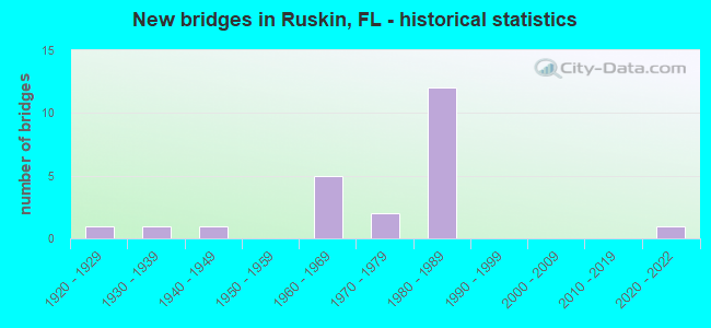
- New bridges - historical statistics
- 11920-1929
- 11930-1939
- 11940-1949
- 51960-1969
- 21970-1979
- 121980-1989
- 12020-2022

- Reconstructed bridges - Historical Statistics
- 11950-1959
- 11960-1969
- 11970-1979
- 01980-1989
- 01990-1999
- 12000-2009


- Bridge Condition - Deck
- 6.3%Very good
- 75.0%Good
- 12.5%Satisfactory
- 6.3%Fair

- Bridge Condition - Superstructure
- 6.3%Very good
- 75.0%Good
- 6.3%Satisfactory
- 12.5%Fair

- Bridge Condition - Substructure
- 12.5%Very good
- 56.3%Good
- 31.3%Satisfactory

- Bridge Condition - Channel
- 6.7%Very good
- 60.0%Good
- 33.3%Satisfactory

- Bridge Condition - Culverts
- 25.0%Good
- 75.0%Satisfactory
Find on map >> Show street view
Structure Number: 10094, Location: 4.8MI NORTH OF I-75 (Lat: 26.981089, Lng: -81.959308), Route carried "on" structure: US 17, Year Built: 1986, Year Reconstructed: 2005, Status: Open, Structure Length: 3.41m (11.19ft), Average Daily Traffic: 6,250 (year 2020), Truck Traffic: 19%, Average Future Daily Traffic: 10,844 (year 2042), Design Load: HS 20, Features Intersected: SHELL CREEK SO. SLOUGH
Minimum Vertical Clearance: 30.45m (99.90ft), Kilometerpoint: 1.128, Lanes on structure: 2, Base Highway Network: Yes, Owner: State Highway Agency, Approaching Roadway Width: 9.0m (29.5ft), Material/Design: Prestressed concrete, Design/Construction: Slab, Number Of Spans In Main Unit: 3, Length of Maximum Span: 11.3m (37.1ft), Curb or Sidewalk Widths: Left: 1.5m (4.9ft), Right: 0.0m, Curb-To-Curb Width: 11.3m (37.1ft), Out-to-Out Width: 14.2m (46.6ft)
Condition: Deck: Fair, Superstructure: Fair, Substructure: Good, Channel: Good, Operating Rating: 65.0 metric tons, Method Used To Determine Operating Rating: Load Factor (LF), Inventory Rating: 31.7 metric tons, Method Used To Determine Inventory Rating: Load Factor (LF), Structural Evaluation: Somewhat better than minimum adequacy, Deck Geometry: Equal to present minimum criteria, Waterway Adequacy: Equal to present desirable criteria, Approach Roadway Alignment: Equal to present desirable criteria, Designated Inspection Frequency: Every 24 months, Underwater Inspection Frequency: Every 24 months, Inspection Date: May 2020, Underwater Inspection Date: April 2020, Deck Structure Type: Concrete Precast Panels, Wearing Surface/Protective System: Wearing Surface: Bituminous
Find on map >> Show street view
Structure Number: 100002, Location: 2.5MI S OF SAFFOLD RD (Lat: 27.650503, Lng: -82.379586), Route carried "on" structure: US 301, Year Built: 1924, Year Reconstructed: 1970, Status: Open, Structure Length: 1.02m (3.35ft), Average Daily Traffic: 6,100 (year 2020), Truck Traffic: 12%, Average Future Daily Traffic: 10,584 (year 2042), Design Load: H 15, Features Intersected: LIGHTFOOT CREEK
Minimum Vertical Clearance: 30+ m (98+ ft), Kilometerpoint: 0.687, Lanes on structure: 2, Base Highway Network: Yes, Owner: State Highway Agency, Approaching Roadway Width: 9.5m (31.2ft), Material/Design: Concrete, Design/Construction: Culvert, Number Of Spans In Main Unit: 4, Length of Maximum Span: 5.1m (16.7ft)
Condition: Channel: Satisfactory, Culverts: Satisfactory, Operating Rating: 46.3 metric tons, Method Used To Determine Operating Rating: Load Factor (LF), Inventory Rating: 28.1 metric tons, Method Used To Determine Inventory Rating: Load Factor (LF), Structural Evaluation: Equal to present minimum criteria, Waterway Adequacy: Better than present minimum criteria, Approach Roadway Alignment: Equal to present desirable criteria, Designated Inspection Frequency: Every 24 months, Inspection Date: March 2021
Find on map >> Show street view
Structure Number: 100039, Location: 1.3MI SOUTH OF SR-674 (Lat: 27.704317, Lng: -82.448292), Route carried "on" structure: US 41, Year Built: 1971, Status: Open, Structure Length: 22.52m (73.88ft), Average Daily Traffic: 8,500 (year 2021), Truck Traffic: 4%, Average Future Daily Traffic: 14,748 (year 2041), Design Load: HL 93, Features Intersected: LITTLE MANATEE RIVER
Minimum Vertical Clearance: 30+ m (98+ ft), Kilometerpoint: 10.018, Lanes on structure: 2, Base Highway Network: Yes (Inventory Route: 100600, Subroute: 1), Owner: State Highway Agency, Approaching Roadway Width: 10.8m (35.4ft), Navigation Control: Yes ( Vertical Clearance: 6.7m (22.0ft), Horizontal Clearance: 15.2m (49.9ft)), Material/Design: Prestressed concrete, Design/Construction: Stringer/Multi-beam, Number Of Spans In Main Unit: 15, Length of Maximum Span: 21.9m (71.9ft), Curb or Sidewalk Widths: Left: 1.6m (5.2ft), Right: 0.0m, Curb-To-Curb Width: 10.3m (33.8ft), Out-to-Out Width: 13.4m (44.0ft)
Condition: Deck: Good, Superstructure: Good, Substructure: Satisfactory, Channel: Good, Operating Rating: 41.8 metric tons, Method Used To Determine Operating Rating: Load and Resistance Factor (LRFR), Inventory Rating: 32.7 metric tons, Method Used To Determine Inventory Rating: Load and Resistance Factor (LRFR), Structural Evaluation: Equal to present minimum criteria, Deck Geometry: Somewhat better than minimum adequacy, Waterway Adequacy: Equal to present desirable criteria, Approach Roadway Alignment: Better than present minimum criteria, Length Of Structure Improvement: 2.31m (7.58ft), Designated Inspection Frequency: Every 24 months, Underwater Inspection Frequency: Every 24 months, Inspection Date: March 2021, Underwater Inspection Date: Febuary 2021, Bridge Improvement Cost: $10,000, Roadway Improvement Cost: $1,000, Total Project Cost: $11,000, Deck Structure Type: Concrete Cast-file-Place
Find on map >> Show street view
Structure Number: 100099, Location: 0.5MI NORTH OF SR 674 (Lat: 27.719083, Lng: -82.434028), Route carried "on" structure: US 41, Year Built: 1960, Status: Open, Structure Length: 0.75m (2.46ft), Average Daily Traffic: 22,000 (year 2021), Truck Traffic: 7%, Average Future Daily Traffic: 38,170 (year 2041), Design Load: H 20, Features Intersected: GOAT CREEK
Minimum Vertical Clearance: 30+ m (98+ ft), Kilometerpoint: 12.909, Lanes on structure: 4, Base Highway Network: Yes, Owner: State Highway Agency, Approaching Roadway Width: 19.8m (65.0ft), Skew: 10 degrees, Material/Design: Concrete, Design/Construction: Culvert, Number Of Spans In Main Unit: 2, Length of Maximum Span: 3.9m (12.8ft)
Condition: Channel: Good, Culverts: Good, Operating Rating: 67.1 metric tons, Method Used To Determine Operating Rating: Load Factor (LF), Inventory Rating: 39.9 metric tons, Method Used To Determine Inventory Rating: Load Factor (LF), Structural Evaluation: Better than present minimum criteria, Waterway Adequacy: Equal to present desirable criteria, Approach Roadway Alignment: Equal to present desirable criteria, Designated Inspection Frequency: Every 24 months, Underwater Inspection Frequency: Every 24 months, Inspection Date: March 2021, Underwater Inspection Date: Febuary 2021
Find on map >> Show street view
Structure Number: 100104, Location: 1.3MI S OF SR-674 (Lat: 27.704139, Lng: -82.448283), Route carried "on" structure: US 41, Year Built: 1964, Status: Open, Structure Length: 22.55m (73.98ft), Average Daily Traffic: 8,500 (year 2021), Truck Traffic: 4%, Average Future Daily Traffic: 14,748 (year 2041), Design Load: HL 93, Features Intersected: LITTLE MANATEE RIVER
Minimum Vertical Clearance: 30+ m (98+ ft), Kilometerpoint: 10.018, Lanes on structure: 2, Base Highway Network: Yes, Owner: State Highway Agency, Approaching Roadway Width: 9.4m (30.8ft), Navigation Control: Yes ( Vertical Clearance: 6.7m (22.0ft), Horizontal Clearance: 15.2m (49.9ft)), Material/Design: Prestressed concrete, Design/Construction: Stringer/Multi-beam, Number Of Spans In Main Unit: 15, Length of Maximum Span: 21.9m (71.9ft), Curb-To-Curb Width: 9.3m (30.5ft), Out-to-Out Width: 10.2m (33.5ft)
Condition: Deck: Good, Superstructure: Good, Substructure: Good, Channel: Good, Operating Rating: 41.8 metric tons, Method Used To Determine Operating Rating: Load and Resistance Factor (LRFR), Inventory Rating: 32.7 metric tons, Method Used To Determine Inventory Rating: Load and Resistance Factor (LRFR), Structural Evaluation: Better than present minimum criteria, Deck Geometry: Meets minimum limits, Waterway Adequacy: Equal to present desirable criteria, Approach Roadway Alignment: Better than present minimum criteria, Designated Inspection Frequency: Every 24 months, Underwater Inspection Frequency: Every 24 months, Inspection Date: March 2021, Underwater Inspection Date: Febuary 2021, Deck Structure Type: Concrete Cast-file-Place
Find on map >> Show street view
Structure Number: 100105, Location: 0.2 MI SOUTH OF SR-674 (Lat: 27.710328, Lng: -82.434056), Route carried "on" structure: US 41, Year Built: 1964, Status: Open, Structure Length: 4.57m (14.99ft), Average Daily Traffic: 8,500 (year 2021), Truck Traffic: 4%, Average Future Daily Traffic: 14,748 (year 2041), Design Load: HS 20, Features Intersected: CSX RR
Minimum Vertical Clearance: 30+ m (98+ ft), Kilometerpoint: 11.911, Lanes on structure: 2, Base Highway Network: Yes, Owner: State Highway Agency, Approaching Roadway Width: 10.1m (33.1ft), Skew: 1 degrees, Material/Design: Steel, Design/Construction: Stringer/Multi-beam, Number Of Spans In Main Unit: 3, Length of Maximum Span: 15.2m (49.9ft), Curb or Sidewalk Widths: Left: 0.0m, Right: 1.5m (4.9ft), Curb-To-Curb Width: 8.6m (28.2ft), Out-to-Out Width: 11.9m (39.0ft)
Condition: Deck: Good, Superstructure: Good, Substructure: Good, Inventory Rating: 57.2 metric tons, Method Used To Determine Inventory Rating: Load Factor (LF), Structural Evaluation: Better than present minimum criteria, Deck Geometry: High priority of corrective action, Underclear: Somewhat better than minimum adequacy, Approach Roadway Alignment: Equal to present desirable criteria, Designated Inspection Frequency: Every 24 months, Inspection Date: March 2021, Deck Structure Type: Concrete Cast-file-Place, Wearing Surface/Protective System: Wearing Surface: Bituminous
Find on map >> Show street view
Structure Number: 100279, Location: 0.75MI N OF VALROY RD (Lat: 27.660950, Lng: -82.501681), Route carried "on" structure: US 41, Year Built: 1940, Year Reconstructed: 1965, Status: Open, Structure Length: 0.67m (2.20ft), Average Daily Traffic: 13,100 (year 2021), Truck Traffic: 10%, Average Future Daily Traffic: 22,728 (year 2041), Design Load: HS 20, Features Intersected: COCKROACH CREEK
Minimum Vertical Clearance: 30+ m (98+ ft), Kilometerpoint: 2.900, Lanes on structure: 4, Base Highway Network: Yes, Owner: State Highway Agency, Approaching Roadway Width: 17.5m (57.4ft), Skew: 20 degrees, Material/Design: Concrete, Design/Construction: Culvert, Number Of Spans In Main Unit: 2, Length of Maximum Span: 3.4m (11.2ft)
Condition: Channel: Good, Culverts: Satisfactory, Operating Rating: 55.3 metric tons, Method Used To Determine Operating Rating: Load Factor (LF), Inventory Rating: 33.6 metric tons, Method Used To Determine Inventory Rating: Load Factor (LF), Structural Evaluation: Equal to present minimum criteria, Waterway Adequacy: Better than present minimum criteria, Approach Roadway Alignment: Equal to present desirable criteria, Designated Inspection Frequency: Every 24 months, Inspection Date: March 2021
Find on map >> Show street view
Structure Number: 100351, Location: 4.2MI EAST OF US-41 (Lat: 27.657519, Lng: -82.437506), Route carried "on" structure: County highway , Year Built: 1980, Status: Open, Structure Length: 9.72m (31.89ft), Average Daily Traffic: 50,000 (year 2021), Truck Traffic: 17%, Average Future Daily Traffic: 86,750 (year 2042), Design Load: HS 20+Mod, Features Intersected: I-75 (SR-93), Facility Carried by Structure: VALROY ROAD
Minimum Vertical Clearance: 30+ m (98+ ft), Kilometerpoint: 0.439, Lanes on structure: 2, Lanes under structure: 6, Owner: State Highway Agency, Approaching Roadway Width: 13.4m (44.0ft), Skew: 2 degrees, Material/Design: Steel continuous, Design/Construction: Stringer/Multi-beam, Number Of Spans In Main Unit: 4, Length of Maximum Span: 38.7m (127.0ft), Curb-To-Curb Width: 13.4m (44.0ft), Out-to-Out Width: 14.3m (46.9ft)
Condition: Deck: Satisfactory, Superstructure: Good, Substructure: Very good, Operating Rating: 61.7 metric tons, Method Used To Determine Operating Rating: Load Factor (LF), Inventory Rating: 37.2 metric tons, Method Used To Determine Inventory Rating: Load Factor (LF), Structural Evaluation: Better than present minimum criteria, Deck Geometry: Equal to present minimum criteria, Underclear: Equal to present minimum criteria, Approach Roadway Alignment: Equal to present desirable criteria, Designated Inspection Frequency: Every 24 months, Inspection Date: September 2021, Deck Structure Type: Concrete Precast Panels
Find on map >> Show street view
Structure Number: 100352, Location: 4.5MI SOUTH OF SR-674 (Lat: 27.666614, Lng: -82.432119), Route carried "on" structure: Interstate 75, Year Built: 1981, Status: Open, Structure Length: 42.40m (139.11ft), Average Daily Traffic: 31,000 (year 2020), Truck Traffic: 17%, Average Future Daily Traffic: 53,785 (year 2042), Design Load: HS 20+Mod, Features Intersected: LITTLE MANATEE RIVER
Minimum Vertical Clearance: 30+ m (98+ ft), Kilometerpoint: 3.080, Lanes on structure: 3, Base Highway Network: Yes, Owner: State Highway Agency, Approaching Roadway Width: 17.0m (55.8ft), Skew: 2 degrees, Navigation Control: Yes ( Vertical Clearance: 6.7m (22.0ft), Horizontal Clearance: 19.5m (64.0ft)), Material/Design: Prestressed concrete, Design/Construction: Stringer/Multi-beam, Number Of Spans In Main Unit: 20, Length of Maximum Span: 21.0m (68.9ft), Curb-To-Curb Width: 17.0m (55.8ft), Out-to-Out Width: 17.9m (58.7ft)
Condition: Deck: Good, Superstructure: Good, Substructure: Satisfactory, Channel: Good, Operating Rating: 60.5 metric tons, Method Used To Determine Operating Rating: Load Factor (LF), Inventory Rating: 36.3 metric tons, Method Used To Determine Inventory Rating: Load Factor (LF), Structural Evaluation: Equal to present minimum criteria, Deck Geometry: Equal to present minimum criteria, Waterway Adequacy: Superior to present desirable criteria, Approach Roadway Alignment: Equal to present desirable criteria, Length Of Structure Improvement: 4.21m (13.81ft), Designated Inspection Frequency: Every 24 months, Underwater Inspection Frequency: Every 24 months, Inspection Date: September 2021, Underwater Inspection Date: August 2021, Bridge Improvement Cost: $352,000, Roadway Improvement Cost: $35,000, Total Project Cost: $358,000, Deck Structure Type: Concrete Cast-file-Place
Find on map >> Show street view
Structure Number: 100353, Location: 4.5MI SOUTH OF SR-674 (Lat: 27.667053, Lng: -82.432308), Route carried "on" structure: Interstate 75, Year Built: 1981, Status: Open, Structure Length: 42.40m (139.11ft), Average Daily Traffic: 31,000 (year 2020), Truck Traffic: 17%, Average Future Daily Traffic: 53,785 (year 2042), Design Load: HS 20+Mod, Features Intersected: LITTLE MANATEE RIVER
Minimum Vertical Clearance: 30+ m (98+ ft), Kilometerpoint: 3.061, Lanes on structure: 3, Base Highway Network: Yes (Inventory Route: 100750, Subroute: 71), Owner: State Highway Agency, Approaching Roadway Width: 17.0m (55.8ft), Skew: 2 degrees, Navigation Control: Yes ( Vertical Clearance: 6.7m (22.0ft), Horizontal Clearance: 19.5m (64.0ft)), Material/Design: Prestressed concrete, Design/Construction: Stringer/Multi-beam, Number Of Spans In Main Unit: 20, Length of Maximum Span: 21.0m (68.9ft), Curb-To-Curb Width: 17.0m (55.8ft), Out-to-Out Width: 17.9m (58.7ft)
Condition: Deck: Satisfactory, Superstructure: Good, Substructure: Satisfactory, Channel: Satisfactory, Operating Rating: 60.5 metric tons, Method Used To Determine Operating Rating: Load Factor (LF), Inventory Rating: 36.3 metric tons, Method Used To Determine Inventory Rating: Load Factor (LF), Structural Evaluation: Equal to present minimum criteria, Deck Geometry: Equal to present minimum criteria, Waterway Adequacy: Superior to present desirable criteria, Approach Roadway Alignment: Equal to present desirable criteria, Length Of Structure Improvement: 4.21m (13.81ft), Designated Inspection Frequency: Every 24 months, Underwater Inspection Frequency: Every 24 months, Inspection Date: September 2021, Underwater Inspection Date: August 2021, Bridge Improvement Cost: $352,000, Roadway Improvement Cost: $36,000, Total Project Cost: $388,000, Deck Structure Type: Concrete Cast-file-Place
Find on map >> Show street view
Structure Number: 100354, Location: 2MI S OF SR-674 (Lat: 27.694694, Lng: -82.409514), Route carried "on" structure: County highway , Year Built: 1981, Status: Open, Structure Length: 16.98m (55.71ft), Average Daily Traffic: 500 (year 2020), Truck Traffic: 2%, Average Future Daily Traffic: 868 (year 2042), Design Load: HS 20, Features Intersected: I-75/SR-93, Facility Carried by Structure: 21ST AVENUE
Minimum Vertical Clearance: 30+ m (98+ ft), Kilometerpoint: 0.407, Lanes on structure: 2, Lanes under structure: 6, Owner: State Highway Agency, Approaching Roadway Width: 13.5m (44.3ft), Skew: 5 degrees, Material/Design: Steel continuous, Design/Construction: Stringer/Multi-beam, Number Of Spans In Main Unit: 4, Length of Maximum Span: 68.4m (224.4ft), Curb-To-Curb Width: 13.5m (44.3ft), Out-to-Out Width: 14.4m (47.2ft)
Condition: Deck: Good, Superstructure: Good, Substructure: Good, Operating Rating: 70.8 metric tons, Method Used To Determine Operating Rating: Load Factor (LF), Inventory Rating: 42.6 metric tons, Method Used To Determine Inventory Rating: Load Factor (LF), Structural Evaluation: Better than present minimum criteria, Deck Geometry: Superior to present desirable criteria, Underclear: Equal to present minimum criteria, Approach Roadway Alignment: Equal to present desirable criteria, Designated Inspection Frequency: Every 24 months, Inspection Date: September 2021, Deck Structure Type: Concrete Cast-file-Place
Find on map >> Show street view
Structure Number: 100355, Location: 1.5MI S OF SR-674 (Lat: 27.698417, Lng: -82.402250), Route carried "on" structure: County highway , Year Built: 1980, Status: Open, Structure Length: 10.08m (33.07ft), Average Daily Traffic: 1,500 (year 2021), Truck Traffic: 17%, Average Future Daily Traffic: 2,602 (year 2042), Design Load: HS 20, Features Intersected: I-75, Facility Carried by Structure: 24TH STREET
Minimum Vertical Clearance: 30+ m (98+ ft), Kilometerpoint: 1.579, Lanes on structure: 2, Lanes under structure: 6, Owner: State Highway Agency, Approaching Roadway Width: 13.4m (44.0ft), Skew: 3 degrees, Material/Design: Steel continuous, Design/Construction: Stringer/Multi-beam, Number Of Spans In Main Unit: 4, Length of Maximum Span: 39.7m (130.2ft), Curb-To-Curb Width: 13.4m (44.0ft), Out-to-Out Width: 14.2m (46.6ft)
Condition: Deck: Good, Superstructure: Fair, Substructure: Good, Operating Rating: 63.5 metric tons, Method Used To Determine Operating Rating: Load Factor (LF), Inventory Rating: 38.1 metric tons, Method Used To Determine Inventory Rating: Load Factor (LF), Structural Evaluation: Somewhat better than minimum adequacy, Deck Geometry: Equal to present desirable criteria, Underclear: Somewhat better than minimum adequacy, Approach Roadway Alignment: Equal to present desirable criteria, Designated Inspection Frequency: Every 24 months, Inspection Date: September 2021, Deck Structure Type: Concrete Cast-file-Place
Find on map >> Show street view
Structure Number: 100576, Location: 1 MI EAST OF I-75 (Lat: 27.712286, Lng: -82.368931), Route carried "on" structure: State highway 674, Year Built: 1988, Status: Open, Structure Length: 0.67m (2.20ft), Average Daily Traffic: 40,000 (year 2022), Truck Traffic: 13%, Average Future Daily Traffic: 69,400 (year 2042), Design Load: HS 20+Mod, Features Intersected: CYPRESS CREEK
Minimum Vertical Clearance: 30+ m (98+ ft), Kilometerpoint: 6.439, Lanes on structure: 4, Base Highway Network: Yes, Owner: State Highway Agency, Approaching Roadway Width: 18.9m (62.0ft), Skew: 20 degrees, Material/Design: Concrete, Design/Construction: Culvert, Number Of Spans In Main Unit: 2, Length of Maximum Span: 3.4m (11.2ft)
Condition: Channel: Satisfactory, Culverts: Satisfactory, Structural Evaluation: Equal to present minimum criteria, Waterway Adequacy: Superior to present desirable criteria, Approach Roadway Alignment: Equal to present desirable criteria, Designated Inspection Frequency: Every 24 months, Inspection Date: January 2022
Find on map >> Show street view
Structure Number: 10094, Location: 0.2 MILE SOUTH OF SR 674 (Lat: 27.710344, Lng: -82.434161), Route carried "on" structure: US 41, Year Built: 1938, Year Reconstructed: 1964, Status: Open, Structure Length: 4.58m (15.03ft), Average Daily Traffic: 8,500 (year 2021), Truck Traffic: 4%, Average Future Daily Traffic: 14,748 (year 2041), Design Load: H 15, Features Intersected: CSX RR
Minimum Vertical Clearance: 30+ m (98+ ft), Kilometerpoint: 11.908, Lanes on structure: 2, Base Highway Network: Yes, Owner: State Highway Agency, Approaching Roadway Width: 8.5m (27.9ft), Skew: 1 degrees, Material/Design: Steel, Design/Construction: Stringer/Multi-beam, Number Of Spans In Main Unit: 3, Length of Maximum Span: 15.3m (50.2ft), Curb or Sidewalk Widths: Left: 0.1m (0.3ft), Right: 0.1m (0.3ft), Curb-To-Curb Width: 8.5m (27.9ft), Out-to-Out Width: 10.5m (34.4ft)
Condition: Deck: Good, Superstructure: Good, Substructure: Good, Operating Rating: 41.7 metric tons, Method Used To Determine Operating Rating: Load Factor (LF), Inventory Rating: 25.4 metric tons, Method Used To Determine Inventory Rating: Load Factor (LF), Structural Evaluation: Equal to present minimum criteria, Deck Geometry: High priority of corrective action, Underclear: Somewhat better than minimum adequacy, Approach Roadway Alignment: Equal to present desirable criteria, Designated Inspection Frequency: Every 24 months, Inspection Date: March 2021, Deck Structure Type: Concrete Cast-file-Place, Wearing Surface/Protective System: Wearing Surface: Bituminous
Find on map >> Show street view
Structure Number: 104309, Location: 0.7MI WEST OF US-301 (Lat: 27.657556, Lng: -82.382306), Route carried "on" structure: County highway , Year Built: 1965, Status: Open, Structure Length: 0.80m (2.62ft), Average Daily Traffic: 2,000 (year 2020), Truck Traffic: 5%, Average Future Daily Traffic: 2,500 (year 2040), Design Load: H 15, Features Intersected: BRANCH OF LITTLE MANATEE, Facility Carried by Structure: LIGHTFOOT ROAD
Minimum Vertical Clearance: 30+ m (98+ ft), Kilometerpoint: 0.000, Lanes on structure: 2, Owner: County Highway Agency, Approaching Roadway Width: 7.0m (23.0ft), Material/Design: Prestressed concrete, Design/Construction: Channel Beam, Number Of Spans In Main Unit: 1, Length of Maximum Span: 8.0m (26.2ft), Curb or Sidewalk Widths: Left: 0.3m (1.0ft), Right: 0.3m (1.0ft), Curb-To-Curb Width: 7.3m (24.0ft), Out-to-Out Width: 8.0m (26.2ft)
Condition: Deck: Good, Superstructure: Satisfactory, Substructure: Satisfactory, Channel: Good, Operating Rating: 57.7 metric tons, Method Used To Determine Operating Rating: Load Factor (LF), Inventory Rating: 32.2 metric tons, Method Used To Determine Inventory Rating: Load Factor (LF), Structural Evaluation: Equal to present minimum criteria, Deck Geometry: Meets minimum limits, Waterway Adequacy: Superior to present desirable criteria, Approach Roadway Alignment: Equal to present desirable criteria, Designated Inspection Frequency: Every 24 months, Inspection Date: May 2020, Deck Structure Type: Concrete Cast-file-Place
Find on map >> Show street view
Structure Number: 104321, Location: 0.3MI S OF SHELL PT. RD (Lat: 27.716681, Lng: -82.439306), Route carried "on" structure: County highway , Year Built: 1964, Status: Open, Structure Length: 5.97m (19.59ft), Average Daily Traffic: 1,100 (year 2020), Truck Traffic: 5%, Average Future Daily Traffic: 1,375 (year 2040), Design Load: H 20, Features Intersected: RUSKIN INLET, Facility Carried by Structure: 4TH ST. NW
Minimum Vertical Clearance: 30+ m (98+ ft), Kilometerpoint: 0.000, Lanes on structure: 2, Owner: County Highway Agency, Approaching Roadway Width: 6.2m (20.3ft), Material/Design: Concrete, Design/Construction: Slab, Number Of Spans In Main Unit: 7, Length of Maximum Span: 8.5m (27.9ft), Curb or Sidewalk Widths: Left: 0.3m (1.0ft), Right: 1.1m (3.6ft), Curb-To-Curb Width: 7.3m (24.0ft), Out-to-Out Width: 10.1m (33.1ft)
Condition: Deck: Good, Superstructure: Good, Substructure: Satisfactory, Channel: Good, Operating Rating: 31.9 metric tons, Method Used To Determine Operating Rating: Load Factor (LF), Inventory Rating: 19.1 metric tons, Method Used To Determine Inventory Rating: Load Factor (LF), Structural Evaluation: Somewhat better than minimum adequacy, Deck Geometry: Meets minimum limits, Waterway Adequacy: Superior to present desirable criteria, Approach Roadway Alignment: Somewhat better than minimum adequacy, Designated Inspection Frequency: Every 24 months, Underwater Inspection Frequency: Every 24 months, Inspection Date: April 2020, Underwater Inspection Date: March 2020, Deck Structure Type: Concrete Cast-file-Place
Find on map >> Show street view
Structure Number: 104329, Location: 2.2MI E OF US-41 (Lat: 27.675028, Lng: -82.446642), Route carried "on" structure: County highway , Year Built: 1976, Status: Open, Structure Length: 0.92m (3.02ft), Average Daily Traffic: 1,640 (year 2020), Truck Traffic: 5%, Average Future Daily Traffic: 2,050 (year 2040), Design Load: HS 20, Features Intersected: WILDCAT CREEK, Facility Carried by Structure: STEPHENS RD.
Minimum Vertical Clearance: 30+ m (98+ ft), Kilometerpoint: 0.000, Lanes on structure: 2, Owner: County Highway Agency, Approaching Roadway Width: 7.3m (24.0ft), Material/Design: Prestressed concrete, Design/Construction: Channel Beam, Number Of Spans In Main Unit: 1, Length of Maximum Span: 9.2m (30.2ft), Curb or Sidewalk Widths: Left: 0.6m (2.0ft), Right: 0.6m (2.0ft), Curb-To-Curb Width: 8.0m (26.2ft), Out-to-Out Width: 9.8m (32.2ft)
Condition: Deck: Good, Superstructure: Good, Substructure: Good, Channel: Good, Operating Rating: 72.4 metric tons, Method Used To Determine Operating Rating: Load Factor (LF), Inventory Rating: 43.5 metric tons, Method Used To Determine Inventory Rating: Load Factor (LF), Structural Evaluation: Better than present minimum criteria, Deck Geometry: Meets minimum limits, Waterway Adequacy: Better than present minimum criteria, Approach Roadway Alignment: Better than present minimum criteria, Designated Inspection Frequency: Every 24 months, Inspection Date: May 2020, Deck Structure Type: Concrete Cast-file-Place
Find on map >> Show street view
Structure Number: 104484, Location: 0.1MI S/O SHELL PNT RD (Lat: 27.718889, Lng: -82.431972), Route carried "on" structure: City street , Year Built: 2021, Status: Open, Structure Length: 1.31m (4.30ft), Average Daily Traffic: 547 (year 2021), Truck Traffic: 6%, Average Future Daily Traffic: 769 (year 2041), Design Load: HL 93, Features Intersected: RUSKIN INLET, Facility Carried by Structure: 2ND ST SE
Minimum Vertical Clearance: 30+ m (98+ ft), Kilometerpoint: 0.000, Lanes on structure: 2, Owner: County Highway Agency, Approaching Roadway Width: 12.5m (41.0ft), Material/Design: Prestressed concrete, Design/Construction: Slab, Number Of Spans In Main Unit: 1, Length of Maximum Span: 13.1m (43.0ft), Curb or Sidewalk Widths: Left: 0.0m, Right: 1.5m (4.9ft), Curb-To-Curb Width: 12.5m (41.0ft), Out-to-Out Width: 15.1m (49.5ft)
Condition: Deck: Very good, Superstructure: Very good, Substructure: Very good, Channel: Very good, Operating Rating: 73.1 metric tons, Method Used To Determine Operating Rating: Load and Resistance Factor (LRFR), Inventory Rating: 56.5 metric tons, Method Used To Determine Inventory Rating: Load and Resistance Factor (LRFR), Structural Evaluation: Equal to present desirable criteria, Deck Geometry: Superior to present desirable criteria, Waterway Adequacy: Equal to present desirable criteria, Approach Roadway Alignment: Equal to present desirable criteria, Designated Inspection Frequency: Every 24 months, Inspection Date: September 2021, Deck Structure Type: Concrete Cast-file-Place, Wearing Surface/Protective System: Wearing Surface: Monolithic Concrete
Find on map >> Show street view
Structure Number: 130105, Location: 5.0 MI N OF I-275 (Lat: 27.641894, Lng: -82.460983), Route carried "on" structure: Interstate 75, Year Built: 1980, Status: Open, Structure Length: 5.49m (18.01ft), Average Daily Traffic: 36,000 (year 2020), Truck Traffic: 13%, Average Future Daily Traffic: 62,460 (year 2042), Design Load: HS 20+Mod, Features Intersected: CURIOSITY CREEK
Minimum Vertical Clearance: 30+ m (98+ ft), Kilometerpoint: 32.200, Lanes on structure: 3, Base Highway Network: Yes, Owner: State Highway Agency, Approaching Roadway Width: 17.0m (55.8ft), Skew: 1 degrees, Material/Design: Concrete, Design/Construction: Slab, Number Of Spans In Main Unit: 6, Length of Maximum Span: 9.1m (29.9ft), Curb-To-Curb Width: 17.0m (55.8ft), Out-to-Out Width: 17.9m (58.7ft)
Condition: Deck: Good, Superstructure: Good, Substructure: Good, Channel: Satisfactory, Operating Rating: 72.6 metric tons, Method Used To Determine Operating Rating: Load Factor (LF), Inventory Rating: 43.5 metric tons, Method Used To Determine Inventory Rating: Load Factor (LF), Structural Evaluation: Better than present minimum criteria, Deck Geometry: Equal to present minimum criteria, Waterway Adequacy: Equal to present desirable criteria, Approach Roadway Alignment: Equal to present desirable criteria, Length Of Structure Improvement: 5.50m (18.04ft), Designated Inspection Frequency: Every 24 months, Inspection Date: August 2021, Bridge Improvement Cost: $40,000, Roadway Improvement Cost: $5,000, Total Project Cost: $45,000, Deck Structure Type: Concrete Cast-file-Place
Find on map >> Show street view
Structure Number: 130106, Location: 5.0 MI N OF I-275 (Lat: 27.641339, Lng: -82.460117), Route carried "on" structure: Interstate 75, Year Built: 1980, Status: Open, Structure Length: 5.49m (18.01ft), Average Daily Traffic: 36,000 (year 2020), Truck Traffic: 13%, Average Future Daily Traffic: 62,460 (year 2042), Design Load: HS 20+Mod, Features Intersected: CURIOSITY CREEK
Minimum Vertical Clearance: 30+ m (98+ ft), Kilometerpoint: 32.190, Lanes on structure: 3, Base Highway Network: Yes, Owner: State Highway Agency, Approaching Roadway Width: 17.0m (55.8ft), Skew: 1 degrees, Material/Design: Concrete, Design/Construction: Slab, Number Of Spans In Main Unit: 6, Length of Maximum Span: 9.1m (29.9ft), Curb-To-Curb Width: 17.0m (55.8ft), Out-to-Out Width: 17.9m (58.7ft)
Condition: Deck: Good, Superstructure: Good, Substructure: Good, Channel: Satisfactory, Operating Rating: 72.6 metric tons, Method Used To Determine Operating Rating: Load Factor (LF), Inventory Rating: 43.5 metric tons, Method Used To Determine Inventory Rating: Load Factor (LF), Structural Evaluation: Better than present minimum criteria, Deck Geometry: Equal to present minimum criteria, Waterway Adequacy: Equal to present desirable criteria, Approach Roadway Alignment: Equal to present desirable criteria, Designated Inspection Frequency: Every 24 months, Inspection Date: August 2021, Deck Structure Type: Concrete Cast-file-Place
Find on map >> Show street view
Structure Number: 100351, Location: 4.2MI EAST OF US-41 (Lat: 27.657519, Lng: -82.437506), Route carried "under" structure: Interstate 75, Year Built: 1980, Structure Length: 0. m, Average Daily Traffic: 62,000 (year 2020), Truck Traffic: 17%, Features Intersected: I-75 (SR-93), Facility Carried by Structure: VALROY ROAD
Minimum Vertical Clearance: 5.08m (16.67ft), Kilometerpoint: 2.095, Lanes on structure: 2, Lanes under structure: 6, Material/Design: Steel continuous, Design/Construction: Stringer/Multi-beam, Length of Maximum Span: 38.7m (127.0ft)
Find on map >> Show street view
Structure Number: 100354, Location: 2MI S OF SR-674 (Lat: 27.694694, Lng: -82.409514), Route carried "under" structure: Interstate 75, Year Built: 1981, Structure Length: 0. m, Average Daily Traffic: 62,000 (year 2020), Truck Traffic: 17%, Features Intersected: I-75/SR-93, Facility Carried by Structure: 21ST AVENUE
Minimum Vertical Clearance: 5.06m (16.60ft), Kilometerpoint: 7.142, Lanes on structure: 2, Lanes under structure: 6, Material/Design: Steel continuous, Design/Construction: Stringer/Multi-beam, Length of Maximum Span: 68.4m (224.4ft)
Find on map >> Show street view
Structure Number: 100355, Location: 1.5MI S OF SR-674 (Lat: 27.698417, Lng: -82.402250), Route carried "under" structure: Interstate 75, Year Built: 1980, Structure Length: 0. m, Average Daily Traffic: 62,000 (year 2020), Truck Traffic: 17%, Features Intersected: I-75, Facility Carried by Structure: 24TH STREET
Minimum Vertical Clearance: 5.00m (16.40ft), Kilometerpoint: 7.965, Lanes on structure: 2, Lanes under structure: 6, Material/Design: Steel continuous, Design/Construction: Stringer/Multi-beam, Length of Maximum Span: 39.7m (130.2ft)