Bridge Statistics for Rockford, Michigan (MI)
Condition, Traffic, Stress, Structural Evaluation, Project Costs
- National Bridge Inventory (NBI) Statistics
- 29Number of bridges
- 292ft / 89.1mTotal length
- $1,510,000Total costs
- 237,377Total average daily traffic
- 18,707Total average daily truck traffic
- National Bridge Inventory (NBI) Registered Bridges for Rockford
- No street view available for this location
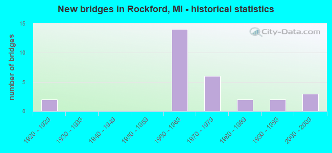
- New bridges - historical statistics
- 21920-1929
- 141960-1969
- 61970-1979
- 21980-1989
- 21990-1999
- 32000-2009


- Bridge Condition - Deck
- 23.5%Very good
- 41.2%Good
- 23.5%Satisfactory
- 5.9%Fair
- 5.9%Poor

- Bridge Condition - Superstructure
- 29.4%Very good
- 23.5%Good
- 47.1%Satisfactory

- Bridge Condition - Substructure
- 23.5%Very good
- 52.9%Good
- 17.6%Satisfactory
- 5.9%Fair

- Bridge Condition - Channel
- 52.4%Very good
- 28.6%Good
- 9.5%Satisfactory
- 9.5%Fair

- Bridge Condition - Culverts
- 50.0%Very good
- 25.0%Good
- 25.0%Fair
Find on map >> Show street view
Structure Number: 503, Location: 7 MI NE OF LANSE (Lat: 46.804419, Lng: -88.316800), Route carried "on" structure: County highway 7760, Year Built: 1999, Status: Open, Structure Length: 2.74m (8.99ft), Average Daily Traffic: 1,060 (year 2014), Truck Traffic: 12%, Average Future Daily Traffic: 1,400 (year 2034), Design Load: HS 25 or greater, Features Intersected: SILVER RIVER, Facility Carried by Structure: SKANEE ROAD
Minimum Vertical Clearance: 30+ m (98+ ft), Kilometerpoint: 13.408, Lanes on structure: 2, Owner: County Highway Agency, Approaching Roadway Width: 10.4m (34.1ft), Skew: 3 degrees, Material/Design: Prestressed concrete, Design/Construction: Box Beam or Girders - Multiple, Number Of Spans In Main Unit: 1, Length of Maximum Span: 26.0m (85.3ft), Curb-To-Curb Width: 11.6m (38.1ft), Out-to-Out Width: 12.4m (40.7ft)
Condition: Deck: Fair, Superstructure: Good, Substructure: Good, Channel: Very good, Operating Rating: 69.3 metric tons, Method Used To Determine Operating Rating: Load Factor (LF), Inventory Rating: 41.6 metric tons, Method Used To Determine Inventory Rating: Load Factor (LF), Structural Evaluation: Better than present minimum criteria, Deck Geometry: Equal to present minimum criteria, Waterway Adequacy: Equal to present desirable criteria, Approach Roadway Alignment: Equal to present desirable criteria, Designated Inspection Frequency: Every 24 months, Inspection Date: September 2021, Deck Structure Type: Concrete Cast-file-Place, Wearing Surface/Protective System: Wearing Surface: Integral Concrete, Deck Protection: Epoxy Coated Reinforcing
Find on map >> Show street view
Structure Number: 523, Location: 5 MI SE OF L'ANSE (Lat: 46.732597, Lng: -88.340883), Route carried "on" structure: County highway , Year Built: 2005, Status: Open, Structure Length: 1.37m (4.49ft), Average Daily Traffic: 68 (year 2015), Truck Traffic: 3%, Average Future Daily Traffic: 100 (year 2035), Design Load: HS 20, Features Intersected: SILVER RIVER, Facility Carried by Structure: SILVER RIVER ROAD
Minimum Vertical Clearance: 30+ m (98+ ft), Kilometerpoint: 0.991, Lanes on structure: 2, Owner: County Highway Agency, Approaching Roadway Width: 9.1m (29.9ft), Material/Design: Prestressed concrete, Design/Construction: Box Beam or Girders - Multiple, Number Of Spans In Main Unit: 1, Length of Maximum Span: 12.5m (41.0ft), Curb-To-Curb Width: 8.8m (28.9ft), Out-to-Out Width: 9.6m (31.5ft)
Condition: Deck: Very good, Superstructure: Very good, Substructure: Good, Channel: Very good, Operating Rating: 70.6 metric tons, Method Used To Determine Operating Rating: Load Factor (LF) rating reported by rating factor (RF) method using MS18 loading, Inventory Rating: 42.1 metric tons, Method Used To Determine Inventory Rating: Load Factor (LF) rating reported by rating factor (RF) method using MS18 loading, Structural Evaluation: Better than present minimum criteria, Waterway Adequacy: Better than present minimum criteria, Approach Roadway Alignment: Equal to present minimum criteria, Designated Inspection Frequency: Every 24 months, Inspection Date: September 2021, Deck Structure Type: Concrete Precast Panels, Wearing Surface/Protective System: Wearing Surface: Bituminous, Membrane: Preformed Fabric, Deck Protection: Epoxy Coated Reinforcing
Find on map >> Show street view
Structure Number: 4981, Location: 1.8 MI S OF M-57 (Lat: 43.153147, Lng: -85.581992), Route carried "on" structure: US 131, Year Built: 1969, Status: Open, Structure Length: 4.26m (13.98ft), Average Daily Traffic: 58,420 (year 2010), Truck Traffic: 7%, Average Future Daily Traffic: 63,585 (year 2025), Design Load: HS 20, Features Intersected: ROGUE RIVER
Minimum Vertical Clearance: 30.48m (100.00ft), Kilometerpoint: 45.987, Lanes on structure: 2, Base Highway Network: Yes (Inventory Route: 41, Subroute: 3), Owner: State Highway Agency, Approaching Roadway Width: 12.8m (42.0ft), Material/Design: Prestressed concrete, Design/Construction: Stringer/Multi-beam, Number Of Spans In Main Unit: 3, Length of Maximum Span: 14.3m (46.9ft), Curb or Sidewalk Widths: Left: 0.2m (0.7ft), Right: 0.2m (0.7ft), Curb-To-Curb Width: 12.5m (41.0ft), Out-to-Out Width: 13.1m (43.0ft)
Condition: Deck: Good, Superstructure: Satisfactory, Substructure: Fair, Channel: Satisfactory, Operating Rating: 69.7 metric tons, Method Used To Determine Operating Rating: Load Factor (LF) rating reported by rating factor (RF) method using MS18 loading, Inventory Rating: 41.8 metric tons, Method Used To Determine Inventory Rating: Load Factor (LF) rating reported by rating factor (RF) method using MS18 loading, Structural Evaluation: Somewhat better than minimum adequacy, Deck Geometry: Better than present minimum criteria, Waterway Adequacy: Equal to present minimum criteria, Approach Roadway Alignment: Equal to present desirable criteria, Designated Inspection Frequency: Every 24 months, Inspection Date: October 2021, Deck Structure Type: Concrete Cast-file-Place, Wearing Surface/Protective System: Wearing Surface: Monolithic Concrete
Find on map >> Show street view
Structure Number: 4982, Location: 1.8 MI S OF M-57 (Lat: 43.154922, Lng: -85.582200), Route carried "on" structure: US 131, Year Built: 1969, Status: Open, Structure Length: 4.26m (13.98ft), Average Daily Traffic: 14,934 (year 2007), Truck Traffic: 12%, Average Future Daily Traffic: 25,657 (year 2018), Design Load: HS 20, Features Intersected: ROGUE RIVER
Minimum Vertical Clearance: 30.48m (100.00ft), Kilometerpoint: 46.285, Lanes on structure: 2, Base Highway Network: Yes (Inventory Route: 41, Subroute: 7), Owner: State Highway Agency, Approaching Roadway Width: 12.8m (42.0ft), Skew: 1 degrees, Material/Design: Prestressed concrete, Design/Construction: Stringer/Multi-beam, Number Of Spans In Main Unit: 3, Length of Maximum Span: 14.3m (46.9ft), Curb or Sidewalk Widths: Left: 0.2m (0.7ft), Right: 0.2m (0.7ft), Curb-To-Curb Width: 12.5m (41.0ft), Out-to-Out Width: 13.1m (43.0ft)
Condition: Deck: Good, Superstructure: Satisfactory, Substructure: Good, Channel: Satisfactory, Operating Rating: 69.7 metric tons, Method Used To Determine Operating Rating: Load Factor (LF) rating reported by rating factor (RF) method using MS18 loading, Inventory Rating: 41.8 metric tons, Method Used To Determine Inventory Rating: Load Factor (LF) rating reported by rating factor (RF) method using MS18 loading, Structural Evaluation: Equal to present minimum criteria, Deck Geometry: Better than present minimum criteria, Waterway Adequacy: Equal to present minimum criteria, Approach Roadway Alignment: Better than present minimum criteria, Designated Inspection Frequency: Every 24 months, Inspection Date: October 2021, Deck Structure Type: Concrete Cast-file-Place, Wearing Surface/Protective System: Wearing Surface: Latex Concrete
Find on map >> Show street view
Structure Number: 4993, Location: 4.3 MI S OF M-57 (Lat: 43.116956, Lng: -85.606547), Route carried "on" structure: County highway 4162, Year Built: 1969, Status: Open, Structure Length: 9.32m (30.58ft), Average Daily Traffic: 6,058 (year 1997), Truck Traffic: 6%, Average Future Daily Traffic: 10,941 (year 2017), Design Load: H 20, Features Intersected: US-131, Facility Carried by Structure: 10 MI RD
Minimum Vertical Clearance: 30.48m (100.00ft), Kilometerpoint: 14.864, Lanes on structure: 2, Lanes under structure: 4, Owner: State Highway Agency, Approaching Roadway Width: 13.4m (44.0ft), Skew: 1 degrees, Material/Design: Steel, Design/Construction: Stringer/Multi-beam, Number Of Spans In Main Unit: 4, Length of Maximum Span: 34.1m (111.9ft), Curb or Sidewalk Widths: Left: 0.2m (0.7ft), Right: 0.2m (0.7ft), Curb-To-Curb Width: 13.4m (44.0ft), Out-to-Out Width: 14.1m (46.3ft)
Condition: Deck: Satisfactory, Superstructure: Satisfactory, Substructure: Satisfactory, Operating Rating: 58.6 metric tons, Method Used To Determine Operating Rating: Load Factor (LF), Inventory Rating: 35.1 metric tons, Method Used To Determine Inventory Rating: Load Factor (LF), Structural Evaluation: Equal to present minimum criteria, Deck Geometry: Equal to present minimum criteria, Underclear: Equal to present minimum criteria, Approach Roadway Alignment: Equal to present minimum criteria, Designated Inspection Frequency: Every 24 months, Inspection Date: August 2020, Deck Structure Type: Concrete Cast-file-Place, Wearing Surface/Protective System: Wearing Surface: Monolithic Concrete
Find on map >> Show street view
Structure Number: 4994, Location: 2.1 MI S OF M-57 (Lat: 43.146269, Lng: -85.587597), Route carried "on" structure: County highway , Year Built: 1969, Status: Open, Structure Length: 11.86m (38.91ft), Average Daily Traffic: 835 (year 1995), Truck Traffic: 6%, Average Future Daily Traffic: 1,508 (year 2015), Design Load: H 20, Features Intersected: US-131, Facility Carried by Structure: 12 MI RD
Minimum Vertical Clearance: 30.48m (100.00ft), Kilometerpoint: 3.121, Lanes on structure: 2, Lanes under structure: 4, Owner: State Highway Agency, Approaching Roadway Width: 10.9m (35.8ft), Skew: 2 degrees, Material/Design: Steel, Design/Construction: Stringer/Multi-beam, Number Of Spans In Main Unit: 5, Length of Maximum Span: 33.5m (109.9ft), Curb or Sidewalk Widths: Left: 0.2m (0.7ft), Right: 0.2m (0.7ft), Curb-To-Curb Width: 11.5m (37.7ft), Out-to-Out Width: 12.3m (40.4ft)
Condition: Deck: Poor, Superstructure: Satisfactory, Substructure: Good, Operating Rating: 65.4 metric tons, Method Used To Determine Operating Rating: Load Factor (LF) rating reported by rating factor (RF) method using MS18 loading, Inventory Rating: 39.2 metric tons, Method Used To Determine Inventory Rating: Load Factor (LF) rating reported by rating factor (RF) method using MS18 loading, Structural Evaluation: Equal to present minimum criteria, Deck Geometry: Better than present minimum criteria, Underclear: Better than present minimum criteria, Approach Roadway Alignment: Better than present minimum criteria, Designated Inspection Frequency: Every 24 months, Inspection Date: October 2020, Deck Structure Type: Concrete Cast-file-Place, Wearing Surface/Protective System: Wearing Surface: Monolithic Concrete
Find on map >> Show street view
Structure Number: 4995, Location: 1.1 MI S OF M-57 (Lat: 43.160975, Lng: -85.578222), Route carried "on" structure: US 131, Year Built: 1969, Status: Open, Structure Length: 5.07m (16.63ft), Average Daily Traffic: 14,934 (year 2007), Truck Traffic: 12%, Average Future Daily Traffic: 25,657 (year 2018), Design Load: HS 20, Features Intersected: 13 MILE RD
Minimum Vertical Clearance: 30.48m (100.00ft), Kilometerpoint: 47.033, Lanes on structure: 2, Lanes under structure: 2, Base Highway Network: Yes (Inventory Route: 41, Subroute: 7), Owner: State Highway Agency, Approaching Roadway Width: 13.4m (44.0ft), Skew: 2 degrees, Material/Design: Steel, Design/Construction: Stringer/Multi-beam, Number Of Spans In Main Unit: 3, Length of Maximum Span: 28.0m (91.9ft), Curb-To-Curb Width: 11.9m (39.0ft), Out-to-Out Width: 13.1m (43.0ft)
Condition: Deck: Satisfactory, Superstructure: Satisfactory, Substructure: Good, Operating Rating: 69.0 metric tons, Method Used To Determine Operating Rating: Load Factor (LF) rating reported by rating factor (RF) method using MS18 loading, Inventory Rating: 41.1 metric tons, Method Used To Determine Inventory Rating: Load Factor (LF) rating reported by rating factor (RF) method using MS18 loading, Structural Evaluation: Equal to present minimum criteria, Deck Geometry: Better than present minimum criteria, Underclear: Equal to present minimum criteria, Approach Roadway Alignment: Better than present minimum criteria, Designated Inspection Frequency: Every 24 months, Inspection Date: October 2021, Deck Structure Type: Concrete Cast-file-Place, Wearing Surface/Protective System: Wearing Surface: Epoxy Overlay
Find on map >> Show street view
Structure Number: 503, Location: 400 FT W OF MAIN STREET (Lat: 43.117400, Lng: -85.561672), Route carried "on" structure: County highway 4162, Year Built: 1977, Status: Open, Structure Length: 9.32m (30.58ft), Average Daily Traffic: 16,978 (year 2018), Truck Traffic: 3%, Average Future Daily Traffic: 20,734 (year 2038), Design Load: HS 20+Mod, Features Intersected: ROGUE R & WHITE PINE TRL, Facility Carried by Structure: 10 MILE ROAD
Minimum Vertical Clearance: 30.48m (100.00ft), Kilometerpoint: 18.516, Lanes on structure: 4, Owner: County Highway Agency, Approaching Roadway Width: 15.8m (51.8ft), Skew: 1 degrees, Material/Design: Prestressed concrete, Design/Construction: Box Beam or Girders - Multiple, Number Of Spans In Main Unit: 4, Length of Maximum Span: 23.4m (76.8ft), Curb or Sidewalk Widths: Left: 1.5m (4.9ft), Right: 1.5m (4.9ft), Curb-To-Curb Width: 15.8m (51.8ft), Out-to-Out Width: 19.4m (63.6ft)
Condition: Deck: Good, Superstructure: Very good, Substructure: Good, Channel: Very good, Operating Rating: 43.4 metric tons, Method Used To Determine Operating Rating: Load and Resistance Factor Rating (LRFR) rating reported by rating factor(RF) method using HL-93 loadings, Inventory Rating: 30.1 metric tons, Method Used To Determine Inventory Rating: Load and Resistance Factor Rating (LRFR) rating reported by rating factor(RF) method using HL-93 loadings, Structural Evaluation: Better than present minimum criteria, Deck Geometry: Meets minimum limits, Waterway Adequacy: Equal to present desirable criteria, Approach Roadway Alignment: Equal to present desirable criteria, Designated Inspection Frequency: Every 24 months, Inspection Date: October 2020, Deck Structure Type: Concrete Precast Panels, Wearing Surface/Protective System: Wearing Surface: Bituminous, Membrane: Preformed Fabric
Find on map >> Show street view
Structure Number: 5054, Location: 0.30 MI N OF 11 MILE RD (Lat: 43.136108, Lng: -85.610908), Route carried "on" structure: County highway 4137, Year Built: 1961, Status: Open, Structure Length: 3.23m (10.60ft), Average Daily Traffic: 4,511 (year 2004), Average Future Daily Traffic: 7,670 (year 2024), Design Load: HS 20+Mod, Features Intersected: ROGUE RIVER, Facility Carried by Structure: ALGOMA AVE
Minimum Vertical Clearance: 30.48m (100.00ft), Kilometerpoint: 2.131, Lanes on structure: 2, Owner: County Highway Agency, Approaching Roadway Width: 9.1m (29.9ft), Skew: 3 degrees, Material/Design: Prestressed concrete, Design/Construction: Box Beam or Girders - Multiple, Number Of Spans In Main Unit: 2, Length of Maximum Span: 16.1m (52.8ft), Curb or Sidewalk Widths: Left: 1.0m (3.3ft), Right: 1.0m (3.3ft), Curb-To-Curb Width: 7.9m (25.9ft), Out-to-Out Width: 10.6m (34.8ft)
Condition: Deck: Very good, Superstructure: Very good, Substructure: Very good, Channel: Very good, Operating Rating: 75.2 metric tons, Method Used To Determine Operating Rating: Load and Resistance Factor Rating (LRFR) rating reported by rating factor(RF) method using HL-93 loadings, Inventory Rating: 53.1 metric tons, Method Used To Determine Inventory Rating: Load and Resistance Factor Rating (LRFR) rating reported by rating factor(RF) method using HL-93 loadings, Structural Evaluation: Equal to present desirable criteria, Deck Geometry: High priority of corrective action, Waterway Adequacy: Equal to present desirable criteria, Approach Roadway Alignment: Equal to present desirable criteria, Designated Inspection Frequency: Every 24 months, Inspection Date: October 2020, Deck Structure Type: Concrete Precast Panels, Wearing Surface/Protective System: Wearing Surface: Bituminous
Find on map >> Show street view
Structure Number: 5055, Location: 0.30 MI N OF 13 MILE RD (Lat: 43.165494, Lng: -85.611094), Route carried "on" structure: County highway 4137, Year Built: 1960, Status: Open, Structure Length: 0.91m (2.99ft), Average Daily Traffic: 3,701 (year 2004), Average Future Daily Traffic: 6,290 (year 2024), Design Load: HS 20+Mod, Features Intersected: CEDAR CREEK, Facility Carried by Structure: ALGOMA AVE
Minimum Vertical Clearance: 30.48m (100.00ft), Kilometerpoint: 5.396, Lanes on structure: 2, Owner: County Highway Agency, Approaching Roadway Width: 8.5m (27.9ft), Material/Design: Steel, Design/Construction: Culvert, Number Of Spans In Main Unit: 2, Length of Maximum Span: 3.9m (12.8ft)
Condition: Channel: Good, Culverts: Very good, Operating Rating: 44.1 metric tons, Method Used To Determine Operating Rating: Load Factor (LF) rating reported by rating factor (RF) method using MS18 loading, Inventory Rating: 37.3 metric tons, Method Used To Determine Inventory Rating: Load Factor (LF) rating reported by rating factor (RF) method using MS18 loading, Structural Evaluation: Equal to present desirable criteria, Waterway Adequacy: Equal to present desirable criteria, Approach Roadway Alignment: Equal to present desirable criteria, Designated Inspection Frequency: Every 24 months, Inspection Date: October 2020
Find on map >> Show street view
Structure Number: 5062, Location: 0.40 MI S OF 13 MILE RD (Lat: 43.155125, Lng: -85.582783), Route carried "on" structure: County highway , Year Built: 1968, Status: Open, Structure Length: 3.59m (11.78ft), Average Daily Traffic: 739 (year 2004), Average Future Daily Traffic: 1,260 (year 2024), Design Load: HS 20+Mod, Features Intersected: ROGUE RIVER, Facility Carried by Structure: EDGERTON AVE
Minimum Vertical Clearance: 30.48m (100.00ft), Kilometerpoint: 2.799, Lanes on structure: 2, Owner: County Highway Agency, Approaching Roadway Width: 12.2m (40.0ft), Skew: 1 degrees, Material/Design: Prestressed concrete, Design/Construction: Box Beam or Girders - Multiple, Number Of Spans In Main Unit: 2, Length of Maximum Span: 17.9m (58.7ft), Curb or Sidewalk Widths: Left: 0.7m (2.3ft), Right: 0.7m (2.3ft), Curb-To-Curb Width: 10.1m (33.1ft), Out-to-Out Width: 11.1m (36.4ft)
Condition: Deck: Good, Superstructure: Satisfactory, Substructure: Very good, Channel: Very good, Operating Rating: 49.9 metric tons, Method Used To Determine Operating Rating: Load and Resistance Factor Rating (LRFR) rating reported by rating factor(RF) method using HL-93 loadings, Inventory Rating: 36.3 metric tons, Method Used To Determine Inventory Rating: Load and Resistance Factor Rating (LRFR) rating reported by rating factor(RF) method using HL-93 loadings, Structural Evaluation: Equal to present minimum criteria, Deck Geometry: Equal to present minimum criteria, Waterway Adequacy: Equal to present desirable criteria, Approach Roadway Alignment: Equal to present desirable criteria, Designated Inspection Frequency: Every 24 months, Inspection Date: October 2020, Deck Structure Type: Concrete Precast Panels, Wearing Surface/Protective System: Wearing Surface: Bituminous
Find on map >> Show street view
Structure Number: 5064, Location: 0.50 MI N OF 13 MILE RD (Lat: 43.168514, Lng: -85.552453), Route carried "on" structure: County highway 4151, Year Built: 2009, Status: Open, Structure Length: 2.29m (7.51ft), Average Daily Traffic: 11,423 (year 2003), Average Future Daily Traffic: 19,420 (year 2023), Design Load: HS 20+Mod, Features Intersected: STEGMAN CREEK, Facility Carried by Structure: NORTHLAND DRIVE
Minimum Vertical Clearance: 30.48m (100.00ft), Kilometerpoint: 17.047, Lanes on structure: 5, Owner: County Highway Agency, Approaching Roadway Width: 21.6m (70.9ft), Material/Design: Prestressed concrete, Design/Construction: Box Beam or Girders - Multiple, Number Of Spans In Main Unit: 1, Length of Maximum Span: 22.1m (72.5ft), Curb-To-Curb Width: 21.6m (70.9ft), Out-to-Out Width: 22.6m (74.1ft)
Condition: Deck: Very good, Superstructure: Very good, Substructure: Very good, Channel: Very good, Operating Rating: 64.2 metric tons, Method Used To Determine Operating Rating: Load and Resistance Factor (LRFR), Inventory Rating: 38.4 metric tons, Method Used To Determine Inventory Rating: Load Factor (LF), Structural Evaluation: Equal to present desirable criteria, Deck Geometry: Somewhat better than minimum adequacy, Waterway Adequacy: Equal to present minimum criteria, Approach Roadway Alignment: Equal to present minimum criteria, Designated Inspection Frequency: Every 24 months, Inspection Date: October 2020, Deck Structure Type: Concrete Cast-file-Place
Find on map >> Show street view
Structure Number: 51, Location: 100 FT E OF FRISKE DRIVE (Lat: 43.146203, Lng: -85.600958), Route carried "on" structure: County highway , Year Built: 1970, Status: Open, Structure Length: 3.41m (11.19ft), Average Daily Traffic: 1,116 (year 2005), Average Future Daily Traffic: 1,900 (year 2025), Design Load: HS 20+Mod, Features Intersected: ROGUE RIVER, Facility Carried by Structure: 12 MILE RD
Minimum Vertical Clearance: 30.48m (100.00ft), Kilometerpoint: 2.034, Lanes on structure: 2, Owner: County Highway Agency, Approaching Roadway Width: 10.4m (34.1ft), Skew: 2 degrees, Material/Design: Prestressed concrete, Design/Construction: Box Beam or Girders - Multiple, Number Of Spans In Main Unit: 2, Length of Maximum Span: 17.0m (55.8ft), Curb-To-Curb Width: 9.4m (30.8ft), Out-to-Out Width: 10.2m (33.5ft)
Condition: Deck: Satisfactory, Superstructure: Satisfactory, Substructure: Good, Channel: Good, Operating Rating: 62.7 metric tons, Method Used To Determine Operating Rating: Load Factor (LF), Inventory Rating: 37.5 metric tons, Method Used To Determine Inventory Rating: Load Factor (LF), Structural Evaluation: Equal to present minimum criteria, Deck Geometry: Somewhat better than minimum adequacy, Waterway Adequacy: Equal to present desirable criteria, Approach Roadway Alignment: Equal to present desirable criteria, Designated Inspection Frequency: Every 24 months, Inspection Date: October 2020, Deck Structure Type: Concrete Precast Panels, Wearing Surface/Protective System: Wearing Surface: Bituminous, Membrane: Other
Find on map >> Show street view
Structure Number: 5102, Location: 0.60 MI W OF SUMMIT AVE (Lat: 43.153681, Lng: -85.577275), Route carried "on" structure: County highway , Year Built: 1981, Status: Open, Structure Length: 1.18m (3.87ft), Average Daily Traffic: 290 (year 2006), Truck Traffic: 1%, Average Future Daily Traffic: 490 (year 2026), Design Load: HS 20+Mod, Features Intersected: STEGMAN CREEK, Facility Carried by Structure: RECTOR ST
Minimum Vertical Clearance: 30.48m (100.00ft), Kilometerpoint: 0.930, Lanes on structure: 2, Owner: County Highway Agency, Approaching Roadway Width: 9.8m (32.2ft), Material/Design: Aluminum, Iron, Design/Construction: Culvert, Number Of Spans In Main Unit: 3, Length of Maximum Span: 3.3m (10.8ft)
Condition: Channel: Fair, Culverts: Very good, Operating Rating: 48.6 metric tons, Method Used To Determine Operating Rating: Assigned rating based on Load Factor Design (LFD) reported by rating factor (RF) using MS18 loading, Inventory Rating: 32.4 metric tons, Method Used To Determine Inventory Rating: Assigned rating based on Load Factor Design (LFD) reported by rating factor (RF) using MS18 loading, Structural Evaluation: Equal to present desirable criteria, Waterway Adequacy: Equal to present desirable criteria, Approach Roadway Alignment: Equal to present desirable criteria, Designated Inspection Frequency: Every 24 months, Inspection Date: October 2020
Find on map >> Show street view
Structure Number: 5107, Location: 0.25 MI S OF 11 MILE RD (Lat: 43.127800, Lng: -85.625383), Route carried "on" structure: County highway , Year Built: 1993, Status: Open, Structure Length: 4.54m (14.90ft), Average Daily Traffic: 172 (year 2003), Average Future Daily Traffic: 290 (year 2023), Design Load: HS 20, Features Intersected: ROGUE RIVER, Facility Carried by Structure: GRANGE AVE
Minimum Vertical Clearance: 30.48m (100.00ft), Kilometerpoint: 0.000, Lanes on structure: 2, Owner: County Highway Agency, Approaching Roadway Width: 9.1m (29.9ft), Material/Design: Wood or Timber, Design/Construction: Slab, Number Of Spans In Main Unit: 1, Number Of Approach Spans: 4, Length of Maximum Span: 21.0m (68.9ft), Curb-To-Curb Width: 9.8m (32.2ft), Out-to-Out Width: 10.3m (33.8ft)
Condition: Deck: Good, Superstructure: Good, Substructure: Very good, Channel: Very good, Operating Rating: 40.5 metric tons, Method Used To Determine Operating Rating: Load Factor (LF), Inventory Rating: 26.7 metric tons, Method Used To Determine Inventory Rating: Load Factor (LF), Structural Evaluation: Equal to present minimum criteria, Deck Geometry: Better than present minimum criteria, Waterway Adequacy: Equal to present desirable criteria, Approach Roadway Alignment: Somewhat better than minimum adequacy, Designated Inspection Frequency: Every 24 months, Inspection Date: October 2020, Deck Structure Type: Wood or Timber, Wearing Surface/Protective System: Wearing Surface: Bituminous
Find on map >> Show street view
Structure Number: 5108, Location: 0.20 MI N OF RECTOR ST (Lat: 43.156181, Lng: -85.602850), Route carried "on" structure: County highway , Year Built: 1976, Status: Open, Structure Length: 0.94m (3.08ft), Average Daily Traffic: 65 (year 2004), Average Future Daily Traffic: 110 (year 2024), Design Load: HS 20+Mod, Features Intersected: CEDAR CREEK, Facility Carried by Structure: FRISKE DRIVE
Minimum Vertical Clearance: 30.48m (100.00ft), Kilometerpoint: 1.165, Lanes on structure: 2, Owner: County Highway Agency, Approaching Roadway Width: 4.3m (14.1ft), Material/Design: Steel, Design/Construction: Culvert, Number Of Spans In Main Unit: 2, Length of Maximum Span: 4.8m (15.7ft)
Condition: Channel: Very good, Culverts: Very good, Operating Rating: 40.8 metric tons, Method Used To Determine Operating Rating: Load Factor (LF) rating reported by rating factor (RF) method using MS18 loading, Inventory Rating: 34.0 metric tons, Method Used To Determine Inventory Rating: Load Factor (LF) rating reported by rating factor (RF) method using MS18 loading, Structural Evaluation: Equal to present desirable criteria, Waterway Adequacy: Equal to present desirable criteria, Approach Roadway Alignment: Equal to present minimum criteria, Designated Inspection Frequency: Every 24 months, Inspection Date: October 2020
Find on map >> Show street view
Structure Number: 511, Location: 0.1 MI WEST OF SUMMIT AVE (Lat: 43.165464, Lng: -85.567581), Route carried "on" structure: County highway , Year Built: 1976, Status: Open, Structure Length: 1.22m (4.00ft), Average Daily Traffic: 106 (year 2006), Truck Traffic: 1%, Average Future Daily Traffic: 180 (year 2026), Design Load: HS 20+Mod, Features Intersected: STEGMAN CREEK, Facility Carried by Structure: SUMMIT COURT
Minimum Vertical Clearance: 30.48m (100.00ft), Kilometerpoint: 0.198, Lanes on structure: 2, Owner: County Highway Agency, Approaching Roadway Width: 8.5m (27.9ft), Material/Design: Steel, Design/Construction: Culvert, Number Of Spans In Main Unit: 3, Length of Maximum Span: 4.2m (13.8ft)
Condition: Channel: Good, Culverts: Very good, Operating Rating: 42.8 metric tons, Method Used To Determine Operating Rating: Load Factor (LF) rating reported by rating factor (RF) method using MS18 loading, Inventory Rating: 35.6 metric tons, Method Used To Determine Inventory Rating: Load Factor (LF) rating reported by rating factor (RF) method using MS18 loading, Structural Evaluation: Equal to present desirable criteria, Waterway Adequacy: Equal to present desirable criteria, Approach Roadway Alignment: Equal to present minimum criteria, Designated Inspection Frequency: Every 24 months, Inspection Date: October 2020
Find on map >> Show street view
Structure Number: 5111, Location: 0.30 MI N OF 13 MI ROAD (Lat: 43.166644, Lng: -85.565886), Route carried "on" structure: County highway , Year Built: 1963, Status: Open, Structure Length: 1.03m (3.38ft), Average Daily Traffic: 1,541 (year 2004), Average Future Daily Traffic: 2,620 (year 2024), Design Load: HS 20+Mod, Features Intersected: STEGMAN CREEK, Facility Carried by Structure: SUMMIT AVE
Minimum Vertical Clearance: 30.48m (100.00ft), Kilometerpoint: 2.276, Lanes on structure: 2, Owner: County Highway Agency, Approaching Roadway Width: 9.1m (29.9ft), Material/Design: Steel, Design/Construction: Culvert, Number Of Spans In Main Unit: 2, Length of Maximum Span: 5.1m (16.7ft)
Condition: Channel: Very good, Culverts: Good, Operating Rating: 42.1 metric tons, Method Used To Determine Operating Rating: Load Factor (LF) rating reported by rating factor (RF) method using MS18 loading, Inventory Rating: 35.3 metric tons, Method Used To Determine Inventory Rating: Load Factor (LF) rating reported by rating factor (RF) method using MS18 loading, Structural Evaluation: Better than present minimum criteria, Waterway Adequacy: Equal to present desirable criteria, Approach Roadway Alignment: Equal to present desirable criteria, Designated Inspection Frequency: Every 24 months, Inspection Date: October 2020
Find on map >> Show street view
Structure Number: 5138, Location: 0.35 MI N OF 10 MILE RD (Lat: 43.121761, Lng: -85.544239), Route carried "on" structure: County highway , Year Built: 1963, Status: Open, Structure Length: 0.64m (2.10ft), Average Daily Traffic: 2,498 (year 2005), Average Future Daily Traffic: 4,250 (year 2025), Design Load: HS 20+Mod, Features Intersected: RUM CREEK, Facility Carried by Structure: COURTLAND DRIVE
Minimum Vertical Clearance: 30.48m (100.00ft), Kilometerpoint: 0.528, Lanes on structure: 2, Owner: County Highway Agency, Approaching Roadway Width: 9.1m (29.9ft), Material/Design: Steel, Design/Construction: Culvert, Number Of Spans In Main Unit: 2, Length of Maximum Span: 2.7m (8.9ft)
Condition: Channel: Good, Culverts: Good, Operating Rating: 53.8 metric tons, Method Used To Determine Operating Rating: Load Factor (LF) rating reported by rating factor (RF) method using MS18 loading, Inventory Rating: 47.6 metric tons, Method Used To Determine Inventory Rating: Load Factor (LF) rating reported by rating factor (RF) method using MS18 loading, Structural Evaluation: Better than present minimum criteria, Waterway Adequacy: Equal to present desirable criteria, Approach Roadway Alignment: Equal to present minimum criteria, Designated Inspection Frequency: Every 24 months, Inspection Date: October 2020
Find on map >> Show street view
Structure Number: 5153, Location: 0.15 MI EAST OF VAN DAM (Lat: 43.093283, Lng: -85.596628), Route carried "on" structure: County highway , Year Built: 1983, Status: Open, Structure Length: 4.36m (14.30ft), Average Daily Traffic: 493 (year 2005), Average Future Daily Traffic: 840 (year 2025), Design Load: HS 20+Mod, Features Intersected: WHITE PINE TRAIL-MDNR, Facility Carried by Structure: PACKER DRIVE
Minimum Vertical Clearance: 30.48m (100.00ft), Kilometerpoint: 1.019, Lanes on structure: 2, Owner: County Highway Agency, Approaching Roadway Width: 6.7m (22.0ft), Material/Design: Prestressed concrete, Design/Construction: Box Beam or Girders - Multiple, Number Of Spans In Main Unit: 3, Length of Maximum Span: 14.6m (47.9ft), Curb-To-Curb Width: 11.6m (38.1ft), Out-to-Out Width: 12.4m (40.7ft)
Condition: Deck: Good, Superstructure: Good, Substructure: Good, Operating Rating: 65.1 metric tons, Method Used To Determine Operating Rating: Load Factor (LF), Inventory Rating: 39.0 metric tons, Method Used To Determine Inventory Rating: Load Factor (LF), Structural Evaluation: Better than present minimum criteria, Deck Geometry: Better than present minimum criteria, Approach Roadway Alignment: Equal to present minimum criteria, Designated Inspection Frequency: Every 24 months, Inspection Date: November 2021, Deck Structure Type: Concrete Cast-file-Place, Wearing Surface/Protective System: Wearing Surface: Bituminous
Find on map >> Show street view
Structure Number: 5154, Location: 0.6 MI N OF KROES ST (Lat: 43.101897, Lng: -85.580197), Route carried "on" structure: County highway , Year Built: 1974, Status: Open, Structure Length: 3.99m (13.09ft), Average Daily Traffic: 2,244 (year 2008), Average Future Daily Traffic: 3,040 (year 2025), Design Load: HS 20, Features Intersected: ROGUE RIVER, Facility Carried by Structure: CHILDSDALE AVE
Minimum Vertical Clearance: 30.48m (100.00ft), Kilometerpoint: 2.071, Lanes on structure: 2, Owner: County Highway Agency, Approaching Roadway Width: 7.9m (25.9ft), Material/Design: Prestressed concrete, Design/Construction: Box Beam or Girders - Multiple, Number Of Spans In Main Unit: 3, Length of Maximum Span: 13.4m (44.0ft), Curb-To-Curb Width: 9.4m (30.8ft), Out-to-Out Width: 10.2m (33.5ft)
Condition: Deck: Very good, Superstructure: Very good, Substructure: Satisfactory, Channel: Good, Operating Rating: 79.7 metric tons, Method Used To Determine Operating Rating: Load Factor (LF) rating reported by rating factor (RF) method using MS18 loading, Inventory Rating: 47.6 metric tons, Method Used To Determine Inventory Rating: Load Factor (LF) rating reported by rating factor (RF) method using MS18 loading, Structural Evaluation: Equal to present minimum criteria, Deck Geometry: Meets minimum limits, Waterway Adequacy: Equal to present desirable criteria, Approach Roadway Alignment: Equal to present minimum criteria, Length Of Structure Improvement: 4.00m (13.12ft), Designated Inspection Frequency: Every 24 months, Inspection Date: November 2021, Bridge Improvement Cost: $1,443,000, Roadway Improvement Cost: $57,000, Total Project Cost: $1,500,000, Deck Structure Type: Concrete Precast Panels, Wearing Surface/Protective System: Wearing Surface: Bituminous, Membrane: Other
Find on map >> Show street view
Structure Number: 5155, Location: 0.6 MI S OF 10 MILE RD (Lat: 43.109486, Lng: -85.565572), Route carried "on" structure: County highway , Year Built: 1971, Status: Open, Structure Length: 4.57m (14.99ft), Average Daily Traffic: 1,947 (year 2005), Average Future Daily Traffic: 3,310 (year 2025), Design Load: HS 20+Mod, Features Intersected: ROGUE RIVER, Facility Carried by Structure: JERICHO AVE
Minimum Vertical Clearance: 30.48m (100.00ft), Kilometerpoint: 1.798, Lanes on structure: 2, Owner: County Highway Agency, Approaching Roadway Width: 6.7m (22.0ft), Skew: 1 degrees, Material/Design: Prestressed concrete, Design/Construction: Box Beam or Girders - Multiple, Number Of Spans In Main Unit: 3, Length of Maximum Span: 15.2m (49.9ft), Curb-To-Curb Width: 9.4m (30.8ft), Out-to-Out Width: 10.2m (33.5ft)
Condition: Deck: Satisfactory, Superstructure: Satisfactory, Substructure: Satisfactory, Channel: Very good, Operating Rating: 51.5 metric tons, Method Used To Determine Operating Rating: Load Factor (LF), Inventory Rating: 30.8 metric tons, Method Used To Determine Inventory Rating: Load Factor (LF), Structural Evaluation: Equal to present minimum criteria, Deck Geometry: Somewhat better than minimum adequacy, Waterway Adequacy: Equal to present desirable criteria, Approach Roadway Alignment: Equal to present desirable criteria, Length Of Structure Improvement: 1.00m (3.28ft), Designated Inspection Frequency: Every 24 months, Inspection Date: November 2021, Bridge Improvement Cost: $10,000, Total Project Cost: $10,000, Deck Structure Type: Concrete Precast Panels, Wearing Surface/Protective System: Wearing Surface: Bituminous
Find on map >> Show street view
Structure Number: 523, Location: 100 FT E OF RIVER ST (Lat: 43.119781, Lng: -85.562275), Route carried "on" structure: City street , Year Built: 2002, Status: Open, Structure Length: 3.05m (10.01ft), Average Daily Traffic: 3,300 (year 2004), Truck Traffic: 6%, Average Future Daily Traffic: 6,000 (year 2024), Design Load: HS 20+Mod, Features Intersected: ROGUE RIVER, Facility Carried by Structure: WEST BRIDGE STREET
Minimum Vertical Clearance: 30.48m (100.00ft), Kilometerpoint: 0.373, Lanes on structure: 2, Owner: City or Municipal Highway Agency, Approaching Roadway Width: 12.2m (40.0ft), Material/Design: Prestressed concrete, Design/Construction: Stringer/Multi-beam, Number Of Spans In Main Unit: 1, Length of Maximum Span: 29.3m (96.1ft), Curb or Sidewalk Widths: Left: 2.4m (7.9ft), Right: 2.4m (7.9ft), Curb-To-Curb Width: 8.5m (27.9ft), Out-to-Out Width: 14.2m (46.6ft)
Condition: Deck: Good, Superstructure: Good, Substructure: Good, Channel: Very good, Operating Rating: 97.2 metric tons, Method Used To Determine Operating Rating: Load Factor (LF) rating reported by rating factor (RF) method using MS18 loading, Inventory Rating: 59.6 metric tons, Method Used To Determine Inventory Rating: Load Factor (LF) rating reported by rating factor (RF) method using MS18 loading, Structural Evaluation: Better than present minimum criteria, Deck Geometry: Meets minimum limits, Waterway Adequacy: Equal to present desirable criteria, Approach Roadway Alignment: Equal to present desirable criteria, Designated Inspection Frequency: Every 24 months, Inspection Date: September 2020, Deck Structure Type: Concrete Cast-file-Place, Wearing Surface/Protective System: Wearing Surface: Monolithic Concrete, Deck Protection: Epoxy Coated Reinforcing
Find on map >> Show street view
Structure Number: 5231, Location: 0.15 MI N OF COURTLAND ST (Lat: 43.123419, Lng: -85.559542), Route carried "on" structure: City street , Year Built: 1922, Status: Open, Structure Length: 0.97m (3.18ft), Average Daily Traffic: 4,600 (year 2004), Average Future Daily Traffic: 8,300 (year 2024), Design Load: HS 20+Mod, Features Intersected: RUM CREEK, Facility Carried by Structure: MAIN STREET
Minimum Vertical Clearance: 30.48m (100.00ft), Kilometerpoint: 1.181, Lanes on structure: 2, Owner: City or Municipal Highway Agency, Approaching Roadway Width: 8.5m (27.9ft), Skew: 1 degrees, Material/Design: Concrete, Design/Construction: Culvert, Number Of Spans In Main Unit: 2, Length of Maximum Span: 4.2m (13.8ft), Curb or Sidewalk Widths: Left: 1.5m (4.9ft), Right: 1.5m (4.9ft), Curb-To-Curb Width: 8.5m (27.9ft), Out-to-Out Width: 19.8m (65.0ft)
Condition: Channel: Fair, Culverts: Fair, Operating Rating: 42.5 metric tons, Method Used To Determine Operating Rating: Field evaluation and documented engineering judgment, Inventory Rating: 32.7 metric tons, Method Used To Determine Inventory Rating: Field evaluation and documented engineering judgment, Structural Evaluation: Somewhat better than minimum adequacy, Deck Geometry: Meets minimum limits, Waterway Adequacy: Equal to present desirable criteria, Approach Roadway Alignment: Equal to present desirable criteria, Designated Inspection Frequency: Every 24 months, Inspection Date: September 2020, Deck Structure Type: Concrete Cast-file-Place, Wearing Surface/Protective System: Wearing Surface: Bituminous, Membrane: Preformed Fabric
Find on map >> Show street view
Structure Number: 5232, Location: 0.14 MI N OF COURTLAND ST (Lat: 43.123953, Lng: -85.558175), Route carried "on" structure: City street , Year Built: 1925, Status: Open, Structure Length: 0.97m (3.18ft), Average Daily Traffic: 900 (year 2004), Average Future Daily Traffic: 1,600 (year 2024), Design Load: HS 20+Mod, Features Intersected: RUM CREEK, Facility Carried by Structure: MONROE STREET
Minimum Vertical Clearance: 30.48m (100.00ft), Kilometerpoint: 1.247, Lanes on structure: 2, Owner: City or Municipal Highway Agency, Approaching Roadway Width: 9.1m (29.9ft), Material/Design: Concrete, Design/Construction: Culvert, Number Of Spans In Main Unit: 1, Length of Maximum Span: 8.5m (27.9ft), Curb or Sidewalk Widths: Left: 1.3m (4.3ft), Right: 1.3m (4.3ft), Curb-To-Curb Width: 9.1m (29.9ft), Out-to-Out Width: 12.3m (40.4ft)
Condition: Channel: Good, Culverts: Fair, Operating Rating: 42.5 metric tons, Method Used To Determine Operating Rating: Field evaluation and documented engineering judgment, Inventory Rating: 32.7 metric tons, Method Used To Determine Inventory Rating: Field evaluation and documented engineering judgment, Structural Evaluation: Somewhat better than minimum adequacy, Deck Geometry: Equal to present minimum criteria, Waterway Adequacy: Equal to present desirable criteria, Approach Roadway Alignment: Equal to present desirable criteria, Designated Inspection Frequency: Every 24 months, Inspection Date: September 2020, Deck Structure Type: Concrete Cast-file-Place, Wearing Surface/Protective System: Wearing Surface: Bituminous
Find on map >> Show street view
Structure Number: 4993, Location: 4.3 MI S OF M-57 (Lat: 43.116956, Lng: -85.606547), Route carried "under" structure: US 131, Year Built: 1969, Structure Length: 0. m, Average Daily Traffic: 48,758 (year 2007), Truck Traffic: 12%, Features Intersected: US-131, Facility Carried by Structure: 10 MI RD
Minimum Vertical Clearance: 4.70m (15.42ft), Kilometerpoint: 41.423, Lanes on structure: 2, Lanes under structure: 4, Material/Design: Steel, Design/Construction: Stringer/Multi-beam, Length of Maximum Span: 34.1m (111.9ft)
Find on map >> Show street view
Structure Number: 4994, Location: 2.1 MI S OF M-57 (Lat: 43.146269, Lng: -85.587597), Route carried "under" structure: US 131, Year Built: 1969, Structure Length: 0. m, Average Daily Traffic: 29,868 (year 2007), Truck Traffic: 12%, Features Intersected: US-131, Facility Carried by Structure: 12 MI RD
Minimum Vertical Clearance: 5.28m (17.32ft), Kilometerpoint: 45.094, Lanes on structure: 2, Lanes under structure: 4, Material/Design: Steel, Design/Construction: Stringer/Multi-beam, Length of Maximum Span: 33.5m (109.9ft)
Find on map >> Show street view
Structure Number: 4995, Location: 1.1 MI S OF M-57 (Lat: 43.160975, Lng: -85.578222), Route carried "under" structure: County highway 4170, Year Built: 1969, Structure Length: 0. m, Average Daily Traffic: 2,909 (year 1996), Truck Traffic: 6%, Features Intersected: 13 MILE RD, Facility Carried by Structure: US-131 SB
Minimum Vertical Clearance: 4.44m (14.57ft), Kilometerpoint: 17.248, Lanes on structure: 2, Lanes under structure: 2, Material/Design: Steel, Design/Construction: Stringer/Multi-beam, Length of Maximum Span: 28.0m (91.9ft)
Find on map >> Show street view
Structure Number: 4996, Location: 1.1 MI S OF M-57 (Lat: 43.160986, Lng: -85.576928), Route carried "under" structure: County highway 4170, Year Built: 1969, Structure Length: 0. m, Average Daily Traffic: 2,909 (year 1996), Truck Traffic: 6%, Features Intersected: 13 MILE RD, Facility Carried by Structure: US-131 NB
Minimum Vertical Clearance: 4.50m (14.76ft), Kilometerpoint: 17.353, Lanes on structure: 2, Lanes under structure: 2, Material/Design: Steel, Design/Construction: Stringer/Multi-beam, Length of Maximum Span: 27.7m (90.9ft)