Bridge Statistics for Riverside, Maryland (MD)
Condition, Traffic, Stress, Structural Evaluation, Project Costs
- National Bridge Inventory (NBI) Statistics
- 15Number of bridges
- 138ft / 41.8mTotal length
- $560,000Total costs
- 410,650Total average daily traffic
- 44,501Total average daily truck traffic
- National Bridge Inventory (NBI) Registered Bridges for Riverside
- No street view available for this location
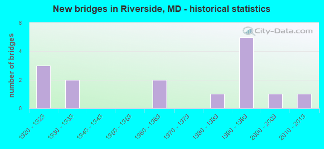
- New bridges - historical statistics
- 31920-1929
- 21930-1939
- 21960-1969
- 11980-1989
- 51990-1999
- 12000-2009
- 12010-2019

- Reconstructed bridges - Historical Statistics
- 11960-1969
- 01970-1979
- 21980-1989
- 11990-1999


- Bridge Condition - Deck
- 11.1%Very good
- 33.3%Good
- 55.6%Satisfactory

- Bridge Condition - Superstructure
- 10.0%Very good
- 30.0%Good
- 40.0%Satisfactory
- 20.0%Fair

- Bridge Condition - Substructure
- 10.0%Very good
- 20.0%Good
- 60.0%Satisfactory
- 10.0%Fair

- Bridge Condition - Channel
- 27.3%Good
- 54.5%Satisfactory
- 18.2%Fair

- Bridge Condition - Culverts
- 33.3%Good
- 66.7%Satisfactory
Find on map >> Show street view
Structure Number: 10000012000801, Location: 1.01 MILES SOUTH OF US 40 (Lat: 39.488561, Lng: -76.214447), Route carried "on" structure: State highway 7, Year Built: 1925, Status: Open, Structure Length: 0.94m (3.08ft), Average Daily Traffic: 12,210 (year 2009), Truck Traffic: 8%, Average Future Daily Traffic: 14,678 (year 2026), Features Intersected: GRAYS RUN
Minimum Vertical Clearance: 30+ m (98+ ft), Kilometerpoint: 16.589, Lanes on structure: 2, Owner: State Highway Agency, Approaching Roadway Width: 8.5m (27.9ft), Material/Design: Concrete, Design/Construction: Tee Beam, Number Of Spans In Main Unit: 1, Length of Maximum Span: 8.5m (27.9ft), Curb-To-Curb Width: 7.6m (24.9ft), Out-to-Out Width: 8.0m (26.2ft)
Condition: Deck: Satisfactory, Superstructure: Fair, Substructure: Fair, Channel: Fair, Operating Rating: 49.9 metric tons, Method Used To Determine Operating Rating: Load Factor (LF), Inventory Rating: 29.9 metric tons, Method Used To Determine Inventory Rating: Load Factor (LF), Structural Evaluation: Somewhat better than minimum adequacy, Deck Geometry: High priority of replacement, Waterway Adequacy: Superior to present desirable criteria, Approach Roadway Alignment: Equal to present desirable criteria, Length Of Structure Improvement: 0.94m (3.08ft), Designated Inspection Frequency: Every 12 months, Inspection Date: August 2021, Bridge Improvement Cost: $49,000, Roadway Improvement Cost: $5,000, Total Project Cost: $54,000, Deck Structure Type: Concrete Cast-file-Place, Wearing Surface/Protective System: Wearing Surface: Bituminous
Find on map >> Show street view
Structure Number: 10000012000901, Location: 0.28 MILE NORTH OF MD 136 (Lat: 39.476600, Lng: -76.260378), Route carried "on" structure: State highway 7, Year Built: 2014, Status: Open, Structure Length: 1.78m (5.84ft), Average Daily Traffic: 12,500 (year 2013), Truck Traffic: 5%, Average Future Daily Traffic: 22,600 (year 2033), Features Intersected: JAMES RUN
Minimum Vertical Clearance: 30+ m (98+ ft), Kilometerpoint: 12.164, Lanes on structure: 2, Owner: State Highway Agency, Approaching Roadway Width: 9.8m (32.2ft), Material/Design: Prestressed concrete, Design/Construction: Box Beam or Girders - Multiple, Number Of Spans In Main Unit: 1, Length of Maximum Span: 16.8m (55.1ft), Curb or Sidewalk Widths: Left: 0.6m (2.0ft), Right: 0.6m (2.0ft), Curb-To-Curb Width: 9.8m (32.2ft), Out-to-Out Width: 11.0m (36.1ft)
Condition: Deck: Very good, Superstructure: Very good, Substructure: Very good, Channel: Good, Operating Rating: 95.9 metric tons, Method Used To Determine Operating Rating: Load and Resistance Factor Rating (LRFR) rating reported by rating factor(RF) method using HL-93 loadings, Inventory Rating: 73.9 metric tons, Method Used To Determine Inventory Rating: Load and Resistance Factor Rating (LRFR) rating reported by rating factor(RF) method using HL-93 loadings, Structural Evaluation: Equal to present desirable criteria, Deck Geometry: Meets minimum limits, Waterway Adequacy: Somewhat better than minimum adequacy, Approach Roadway Alignment: Equal to present desirable criteria, Designated Inspection Frequency: Every 24 months, Inspection Date: July 2020, Wearing Surface/Protective System: Wearing Surface: Monolithic Concrete, Deck Protection: Epoxy Coated Reinforcing
Find on map >> Show street view
Structure Number: 10000012001001, Location: 0.17 MILE SOUTH OF MD 136 (Lat: 39.471925, Lng: -76.266636), Route carried "on" structure: State highway 7, Year Built: 1923, Status: Open, Structure Length: 1.95m (6.40ft), Average Daily Traffic: 11,350 (year 2009), Truck Traffic: 8%, Average Future Daily Traffic: 14,009 (year 2026), Features Intersected: BYNUM RUN
Minimum Vertical Clearance: 30+ m (98+ ft), Kilometerpoint: 11.427, Lanes on structure: 2, Owner: State Highway Agency, Approaching Roadway Width: 8.2m (26.9ft), Material/Design: Concrete, Design/Construction: Tee Beam, Number Of Spans In Main Unit: 2, Length of Maximum Span: 9.1m (29.9ft), Curb-To-Curb Width: 7.3m (24.0ft), Out-to-Out Width: 8.1m (26.6ft)
Condition: Deck: Satisfactory, Superstructure: Satisfactory, Substructure: Satisfactory, Channel: Satisfactory, Operating Rating: 58.5 metric tons, Method Used To Determine Operating Rating: Load Factor (LF), Inventory Rating: 35.8 metric tons, Method Used To Determine Inventory Rating: Load Factor (LF), Structural Evaluation: Equal to present minimum criteria, Deck Geometry: High priority of replacement, Waterway Adequacy: Better than present minimum criteria, Approach Roadway Alignment: Equal to present desirable criteria, Length Of Structure Improvement: 1.95m (6.40ft), Designated Inspection Frequency: Every 24 months, Underwater Inspection Frequency: Every 48 months, Inspection Date: July 2020, Underwater Inspection Date: July 2018, Bridge Improvement Cost: $102,000, Roadway Improvement Cost: $10,000, Total Project Cost: $112,000, Deck Structure Type: Concrete Cast-file-Place, Wearing Surface/Protective System: Wearing Surface: Bituminous
Find on map >> Show street view
Structure Number: 10000012002601, Location: 3.24 MILES EAST OF MD 24 (Lat: 39.461792, Lng: -76.252258), Route carried "on" structure: US 40, Year Built: 1935, Year Reconstructed: 1985, Status: Open, Structure Length: 3.38m (11.09ft), Average Daily Traffic: 21,093 (year 2009), Truck Traffic: 8%, Average Future Daily Traffic: 28,283 (year 2026), Design Load: HS 20, Features Intersected: BUSH CREEK
Minimum Vertical Clearance: 30+ m (98+ ft), Kilometerpoint: 11.681, Lanes on structure: 4, Base Highway Network: Yes, Owner: State Highway Agency, Approaching Roadway Width: 28.7m (94.2ft), Skew: 30 degrees, Material/Design: Steel, Design/Construction: Stringer/Multi-beam, Number Of Spans In Main Unit: 2, Length of Maximum Span: 16.2m (53.1ft), Curb-To-Curb Width: 26.8m (87.9ft), Out-to-Out Width: 27.8m (91.2ft)
Condition: Deck: Satisfactory, Superstructure: Satisfactory, Substructure: Satisfactory, Channel: Satisfactory, Operating Rating: 65.8 metric tons, Method Used To Determine Operating Rating: Load Factor (LF), Inventory Rating: 39.5 metric tons, Method Used To Determine Inventory Rating: Load Factor (LF), Structural Evaluation: Equal to present minimum criteria, Deck Geometry: Superior to present desirable criteria, Waterway Adequacy: Equal to present desirable criteria, Approach Roadway Alignment: Equal to present desirable criteria, Designated Inspection Frequency: Every 24 months, Underwater Inspection Frequency: Every 48 months, Inspection Date: April 2021, Underwater Inspection Date: July 2018, Deck Structure Type: Concrete Cast-file-Place, Wearing Surface/Protective System: Wearing Surface: Monolithic Concrete, Deck Protection: Epoxy Coated Reinforcing
Find on map >> Show street view
Structure Number: 10000012005103, Location: 1.23 MILE SOUTH OF MD 136 (Lat: 39.492025, Lng: -76.258842), Route carried "on" structure: State highway 543, Year Built: 1988, Status: Open, Structure Length: 1.70m (5.58ft), Average Daily Traffic: 18,082 (year 2013), Truck Traffic: 8%, Average Future Daily Traffic: 35,401 (year 2029), Design Load: HS 20, Features Intersected: JAMES RUN
Minimum Vertical Clearance: 30+ m (98+ ft), Kilometerpoint: 3.862, Lanes on structure: 2, Owner: State Highway Agency, Approaching Roadway Width: 13.4m (44.0ft), Skew: 1 degrees, Material/Design: Steel, Design/Construction: Culvert, Length of Maximum Span: 4.9m (16.1ft)
Condition: Channel: Satisfactory, Culverts: Satisfactory, Structural Evaluation: Equal to present minimum criteria, Waterway Adequacy: Equal to present desirable criteria, Approach Roadway Alignment: Equal to present desirable criteria, Designated Inspection Frequency: Every 24 months, Inspection Date: April 2020
Find on map >> Show street view
Structure Number: 10000012007701, Location: 0.23 MILE NORTH OF MD 7 (Lat: 39.484469, Lng: -76.251364), Route carried "on" structure: State highway 543, Year Built: 1991, Status: Open, Structure Length: 11.80m (38.71ft), Average Daily Traffic: 18,391 (year 2006), Truck Traffic: 8%, Average Future Daily Traffic: 21,205 (year 2026), Design Load: HS 20, Features Intersected: IS 95
Minimum Vertical Clearance: 30+ m (98+ ft), Kilometerpoint: 2.735, Lanes on structure: 6, Lanes under structure: 6, Owner: State Highway Agency, Approaching Roadway Width: 31.1m (102.0ft), Skew: 21 degrees, Material/Design: Steel continuous, Design/Construction: Stringer/Multi-beam, Number Of Spans In Main Unit: 3, Length of Maximum Span: 41.1m (134.8ft), Curb-To-Curb Width: 31.1m (102.0ft), Out-to-Out Width: 32.0m (105.0ft)
Condition: Deck: Good, Superstructure: Satisfactory, Substructure: Satisfactory, Operating Rating: 65.3 metric tons, Method Used To Determine Operating Rating: Load Factor (LF), Inventory Rating: 39.0 metric tons, Method Used To Determine Inventory Rating: Load Factor (LF), Structural Evaluation: Equal to present minimum criteria, Deck Geometry: Superior to present desirable criteria, Underclear: Meets minimum limits, Approach Roadway Alignment: Equal to present desirable criteria, Length Of Structure Improvement: 11.80m (38.71ft), Designated Inspection Frequency: Every 24 months, Inspection Date: October 2021, Bridge Improvement Cost: $244,000, Roadway Improvement Cost: $24,000, Total Project Cost: $268,000
Find on map >> Show street view
Structure Number: 10000012008201, Location: 1.17 MILES SOUTH OF MD 7 (Lat: 39.470817, Lng: -76.234197), Route carried "on" structure: State highway 543, Year Built: 1995, Status: Open, Structure Length: 11.58m (37.99ft), Average Daily Traffic: 17,981 (year 2009), Truck Traffic: 8%, Average Future Daily Traffic: 19,717 (year 2026), Design Load: HS 25 or greater, Features Intersected: US 40, CSX RAILROAD
Minimum Vertical Clearance: 30+ m (98+ ft), Kilometerpoint: 0.483, Lanes on structure: 2, Lanes under structure: 4, Owner: State Highway Agency, Approaching Roadway Width: 13.4m (44.0ft), Material/Design: Steel continuous, Design/Construction: Girder and Floorbeam System, Number Of Spans In Main Unit: 3, Length of Maximum Span: 44.2m (145.0ft), Curb-To-Curb Width: 13.4m (44.0ft), Out-to-Out Width: 14.6m (47.9ft)
Condition: Deck: Good, Superstructure: Good, Substructure: Good, Operating Rating: 68.5 metric tons, Method Used To Determine Operating Rating: Allowable Stress (AS), Inventory Rating: 40.8 metric tons, Method Used To Determine Inventory Rating: Allowable Stress (AS), Structural Evaluation: Better than present minimum criteria, Deck Geometry: Equal to present minimum criteria, Underclear: Superior to present desirable criteria, Approach Roadway Alignment: Equal to present desirable criteria, Designated Inspection Frequency: Every 24 months, Inspection Date: June 2021, Deck Structure Type: Concrete Cast-file-Place, Wearing Surface/Protective System: Wearing Surface: Integral Concrete
Find on map >> Show street view
Structure Number: 200000H-001101, Location: 0.6 MILES E OF MD 543 (Lat: 39.504728, Lng: -76.259047), Route carried "on" structure: County highway 474, Year Built: 1930, Year Reconstructed: 1999, Status: Open, Structure Length: 0.98m (3.22ft), Average Daily Traffic: 270 (year 2021), Truck Traffic: 5%, Average Future Daily Traffic: 330 (year 2041), Design Load: HS 25 or greater, Features Intersected: JAMES RUN, Facility Carried by Structure: NOVA SCOTIA ROAD
Minimum Vertical Clearance: 30+ m (98+ ft), Kilometerpoint: 2.735, Lanes on structure: 1, Owner: County Highway Agency, Approaching Roadway Width: 4.9m (16.1ft), Material/Design: Steel, Design/Construction: Stringer/Multi-beam, Number Of Spans In Main Unit: 1, Length of Maximum Span: 8.5m (27.9ft), Curb-To-Curb Width: 4.8m (15.7ft), Out-to-Out Width: 5.5m (18.0ft)
Condition: Deck: Good, Superstructure: Satisfactory, Substructure: Good, Channel: Satisfactory, Inventory Rating: 64.9 metric tons, Method Used To Determine Inventory Rating: Load Factor (LF), Structural Evaluation: Equal to present minimum criteria, Deck Geometry: High priority of corrective action, Waterway Adequacy: Better than present minimum criteria, Approach Roadway Alignment: High priority of corrective action, Designated Inspection Frequency: Every 24 months, Critical Feature Inspection Frequency: Every 24 months, Inspection Date: July 2021, Critical Feature Inspection Date: July 2021, Deck Structure Type: Concrete Cast-file-Place, Wearing Surface/Protective System: Wearing Surface: Monolithic Concrete
Find on map >> Show street view
Structure Number: 200000H-001201, Location: 0.3 MILE N OF CRESWELL RD (Lat: 39.493908, Lng: -76.253347), Route carried "on" structure: County highway 475, Year Built: 1920, Year Reconstructed: 1989, Status: Posted for load, Structure Length: 0.82m (2.69ft), Average Daily Traffic: 300 (year 2019), Truck Traffic: 5%, Average Future Daily Traffic: 375 (year 2039), Features Intersected: TRIB / JAMES RUN, Facility Carried by Structure: CULLUM ROAD
Minimum Vertical Clearance: 30+ m (98+ ft), Kilometerpoint: 1.094, Lanes on structure: 2, Owner: County Highway Agency, Approaching Roadway Width: 7.6m (24.9ft), Material/Design: Steel, Design/Construction: Stringer/Multi-beam, Number Of Spans In Main Unit: 1, Length of Maximum Span: 7.3m (24.0ft), Curb-To-Curb Width: 7.6m (24.9ft), Out-to-Out Width: 7.8m (25.6ft)
Condition: Deck: Satisfactory, Superstructure: Fair, Substructure: Satisfactory, Channel: Fair, Operating Rating: 36.3 metric tons, Method Used To Determine Operating Rating: Load Factor (LF), Inventory Rating: 21.8 metric tons, Method Used To Determine Inventory Rating: Load Factor (LF), Structural Evaluation: Somewhat better than minimum adequacy, Deck Geometry: Somewhat better than minimum adequacy, Waterway Adequacy: Better than present minimum criteria, Approach Roadway Alignment: High priority of corrective action, Length Of Structure Improvement: 0.82m (2.69ft), Designated Inspection Frequency: Every 24 months, Other Special Inspection Frequency: Every 12 months, Inspection Date: July 2021, Other Special Inspection Date: July 2021, Bridge Improvement Cost: $70,000, Roadway Improvement Cost: $35,000, Total Project Cost: $126,000, Deck Structure Type: Corrugated Steel, Wearing Surface/Protective System: Wearing Surface: Bituminous
Find on map >> Show street view
Structure Number: 200000H-017301, Location: 0.5 MILES N. OF MD 7 (Lat: 39.495494, Lng: -76.218956), Route carried "on" structure: County highway , Year Built: 2008, Status: Open, Structure Length: 1.51m (4.95ft), Average Daily Traffic: 515 (year 2019), Truck Traffic: 1%, Average Future Daily Traffic: 628 (year 2039), Features Intersected: TRIB GRAYS RUN, Facility Carried by Structure: BURNT HILL TRAIL
Minimum Vertical Clearance: 30+ m (98+ ft), Kilometerpoint: 1.609, Lanes on structure: 2, Owner: County Highway Agency, Approaching Roadway Width: 11.3m (37.1ft), Skew: 2 degrees, Material/Design: Concrete, Design/Construction: Arch - Deck, Number Of Spans In Main Unit: 1, Length of Maximum Span: 14.6m (47.9ft), Curb or Sidewalk Widths: Left: 1.5m (4.9ft), Right: 1.5m (4.9ft), Curb-To-Curb Width: 11.2m (36.7ft), Out-to-Out Width: 27.5m (90.2ft)
Condition: Superstructure: Good, Substructure: Satisfactory, Channel: Satisfactory, Structural Evaluation: Equal to present minimum criteria, Deck Geometry: Better than present minimum criteria, Waterway Adequacy: Superior to present desirable criteria, Approach Roadway Alignment: Better than present minimum criteria, Designated Inspection Frequency: Every 24 months, Inspection Date: October 2021
Find on map >> Show street view
Structure Number: 200000H-020501, Location: 0.1 MILES N OF MD 7 (Lat: 39.489997, Lng: -76.215817), Route carried "on" structure: County highway 2594, Year Built: 1999, Status: Open, Structure Length: 1.22m (4.00ft), Average Daily Traffic: 166 (year 2019), Truck Traffic: 5%, Average Future Daily Traffic: 202 (year 2039), Design Load: HS 20, Features Intersected: GRAYS RUN, Facility Carried by Structure: HOLLY OAK CIRCLE
Minimum Vertical Clearance: 30+ m (98+ ft), Kilometerpoint: 0.000, Lanes on structure: 2, Owner: County Highway Agency, Approaching Roadway Width: 9.1m (29.9ft), Material/Design: Concrete, Design/Construction: Culvert, Number Of Spans In Main Unit: 1, Length of Maximum Span: 12.2m (40.0ft)
Condition: Channel: Good, Culverts: Good, Operating Rating: 76.6 metric tons, Method Used To Determine Operating Rating: Load Factor (LF), Inventory Rating: 45.8 metric tons, Method Used To Determine Inventory Rating: Load Factor (LF), Structural Evaluation: Better than present minimum criteria, Waterway Adequacy: Superior to present desirable criteria, Approach Roadway Alignment: Equal to present minimum criteria, Designated Inspection Frequency: Every 24 months, Inspection Date: July 2021
Find on map >> Show street view
Structure Number: 300000H-X793011, Location: 6.5 MI N BALT-HAR CO LINE (Lat: 39.476469, Lng: -76.269900), Route carried "on" structure: Interstate 95, Year Built: 1963, Year Reconstructed: 1973, Status: Open, Structure Length: 3.29m (10.79ft), Average Daily Traffic: 63,977 (year 2019), Truck Traffic: 16%, Average Future Daily Traffic: 89,739 (year 2041), Design Load: HS 20, Features Intersected: BYNUM RUN
Minimum Vertical Clearance: 30+ m (98+ ft), Kilometerpoint: 127.594, Lanes on structure: 3, Base Highway Network: Yes, Toll: On toll road, Owner: State Toll Authority, Approaching Roadway Width: 18.3m (60.0ft), Skew: 12 degrees, Material/Design: Steel, Design/Construction: Stringer/Multi-beam, Number Of Spans In Main Unit: 2, Length of Maximum Span: 15.9m (52.2ft), Curb or Sidewalk Widths: Left: 0.5m (1.6ft), Right: 0.0m, Curb-To-Curb Width: 18.3m (60.0ft), Out-to-Out Width: 19.6m (64.3ft)
Condition: Deck: Satisfactory, Superstructure: Good, Substructure: Satisfactory, Channel: Good, Operating Rating: 79.4 metric tons, Method Used To Determine Operating Rating: Load Factor (LF), Inventory Rating: 47.6 metric tons, Method Used To Determine Inventory Rating: Load Factor (LF), Structural Evaluation: Equal to present minimum criteria, Deck Geometry: Better than present minimum criteria, Waterway Adequacy: Equal to present desirable criteria, Approach Roadway Alignment: Equal to present desirable criteria, Designated Inspection Frequency: Every 24 months, Inspection Date: January 2020, Deck Structure Type: Concrete Cast-file-Place, Wearing Surface/Protective System: Wearing Surface: Bituminous
Find on map >> Show street view
Structure Number: 300000H-X83202, Location: Milepost M83.1 (Lat: 39.506467, Lng: -76.213214), Route carried "on" structure: Interstate 95, Year Built: 1963, Status: Open, Structure Length: 0.85m (2.79ft), Average Daily Traffic: 116,162 (year 2019), Truck Traffic: 14%, Average Future Daily Traffic: 154,338 (year 2041), Design Load: HS 20, Features Intersected: GRAYS RUN
Minimum Vertical Clearance: 30+ m (98+ ft), Kilometerpoint: 133.869, Lanes on structure: 6, Base Highway Network: Yes, Toll: On toll road, Owner: State Toll Authority, Approaching Roadway Width: 36.6m (120.1ft), Skew: 2 degrees, Material/Design: Concrete, Design/Construction: Culvert, Number Of Spans In Main Unit: 2, Length of Maximum Span: 4.0m (13.1ft)
Condition: Channel: Satisfactory, Culverts: Satisfactory, Operating Rating: 32.7 metric tons, Method Used To Determine Operating Rating: Field evaluation and documented engineering judgment, Inventory Rating: 32.7 metric tons, Method Used To Determine Inventory Rating: Field evaluation and documented engineering judgment, Structural Evaluation: Equal to present minimum criteria, Waterway Adequacy: Superior to present desirable criteria, Approach Roadway Alignment: Equal to present desirable criteria, Designated Inspection Frequency: Every 24 months, Inspection Date: October 2021
Find on map >> Show street view
Structure Number: 10000012007701, Location: 0.93 MILE NORTH OF MD 136 (Lat: 39.483508, Lng: -76.250825), Route carried "under" structure: Interstate 95, Year Built: 1991, Structure Length: 0. m, Average Daily Traffic: 96,560 (year 2009), Truck Traffic: 8%, Features Intersected: IS 95, Facility Carried by Structure: MD 543
Minimum Vertical Clearance: 4.88m (16.01ft), Kilometerpoint: 12.454, Lanes on structure: 6, Lanes under structure: 6, Material/Design: Steel continuous, Design/Construction: Stringer/Multi-beam, Length of Maximum Span: 41.1m (134.8ft)
Find on map >> Show street view
Structure Number: 10000012008201, Location: .42 M W OF BALD EAGLE WAY (Lat: 39.470817, Lng: -76.234197), Route carried "under" structure: US 40, Year Built: 1995, Structure Length: 0. m, Average Daily Traffic: 21,093 (year 2009), Truck Traffic: 8%, Features Intersected: US 40; CSX RAILROAD, Facility Carried by Structure: MD 543
Minimum Vertical Clearance: 6.10m (20.01ft), Kilometerpoint: 13.500, Lanes on structure: 2, Lanes under structure: 4, Material/Design: Steel continuous, Design/Construction: Girder and Floorbeam System, Length of Maximum Span: 44.2m (145.0ft)