Bridge Statistics for Riverdale, Utah (UT)
Condition, Traffic, Stress, Structural Evaluation, Project Costs
- National Bridge Inventory (NBI) Statistics
- 25Number of bridges
- 325ft / 98.5mTotal length
- 764,726Total average daily traffic
- 133,303Total average daily truck traffic
- National Bridge Inventory (NBI) Registered Bridges for Riverdale
- No street view available for this location
- New bridges - historical statistics
- 91960-1969
- 41970-1979
- 21980-1989
- 31990-1999
- 42000-2009
- 32010-2019
- Bridge Condition - Deck
- 14.3%Good
- 64.3%Satisfactory
- 7.1%Fair
- 14.3%Poor
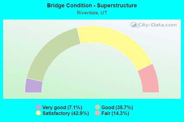
- Bridge Condition - Superstructure
- 7.1%Very good
- 35.7%Good
- 42.9%Satisfactory
- 14.3%Fair
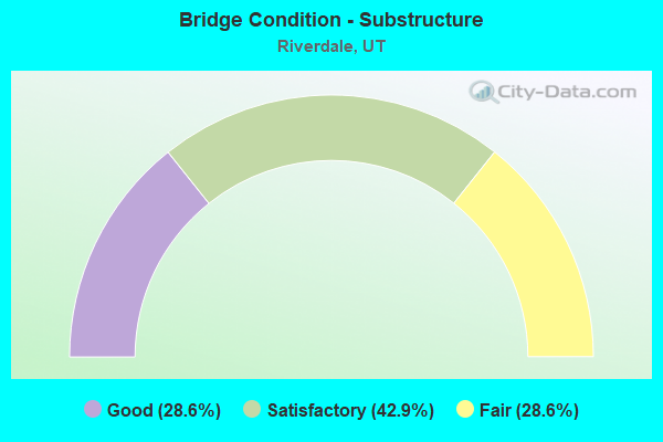
- Bridge Condition - Substructure
- 28.6%Good
- 42.9%Satisfactory
- 28.6%Fair
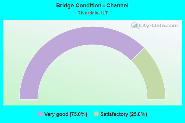
- Bridge Condition - Channel
- 75.0%Very good
- 25.0%Satisfactory
Find on map >> Show street view
Structure Number: 57023F, Location: EAST OF I-15 IN ROY (Lat: 41.163806, Lng: -112.020778), Route carried "on" structure: City street , Year Built: 1980, Status: Open, Structure Length: 0.81m (2.66ft), Average Daily Traffic: 126 (year 2020), Average Future Daily Traffic: 153 (year 2040), Design Load: HL 93, Features Intersected: WEBER-DAVIS CANAL, Facility Carried by Structure: S.S.D.HDQ.ACES.RD.
Minimum Vertical Clearance: 30+ m (98+ ft), Kilometerpoint: 0.000, Lanes on structure: 2, Owner: City or Municipal Highway Agency, Approaching Roadway Width: 7.9m (25.9ft), Material/Design: Prestressed concrete, Design/Construction: Tee Beam, Number Of Spans In Main Unit: 1, Length of Maximum Span: 7.6m (24.9ft), Curb or Sidewalk Widths: Left: 0.0m, Right: 1.7m (5.6ft), Curb-To-Curb Width: 7.9m (25.9ft), Out-to-Out Width: 9.8m (32.2ft)
Condition: Deck: Satisfactory, Superstructure: Satisfactory, Substructure: Satisfactory, Channel: Very good, Operating Rating: 32.4 metric tons, Method Used To Determine Operating Rating: Load and Resistance Factor Rating (LRFR) rating reported by rating factor(RF) method using HL-93 loadings, Inventory Rating: 19.8 metric tons, Method Used To Determine Inventory Rating: Load Factor (LF) rating reported by rating factor (RF) method using MS18 loading, Structural Evaluation: Somewhat better than minimum adequacy, Deck Geometry: Somewhat better than minimum adequacy, Waterway Adequacy: Equal to present minimum criteria, Approach Roadway Alignment: Equal to present desirable criteria, Designated Inspection Frequency: Every 24 months, Inspection Date: April 2020, Deck Structure Type: Concrete Precast Panels, Wearing Surface/Protective System: Wearing Surface: Bituminous
Find on map >> Show street view
Structure Number: 57050F, Location: 600 W. 4600 S., RIVERDALE (Lat: 41.178703, Lng: -111.993689), Route carried "on" structure: City street 3327, Year Built: 1984, Status: Open, Structure Length: 2.87m (9.42ft), Average Daily Traffic: 455 (year 2020), Average Future Daily Traffic: 569 (year 2040), Design Load: H 15, Features Intersected: WEBER RIVER, Facility Carried by Structure: 4600 SO. STREET
Minimum Vertical Clearance: 30+ m (98+ ft), Kilometerpoint: 1.046, Lanes on structure: 2, Owner: City or Municipal Highway Agency, Approaching Roadway Width: 9.0m (29.5ft), Material/Design: Prestressed concrete, Design/Construction: Box Beam or Girders - Multiple, Number Of Spans In Main Unit: 1, Length of Maximum Span: 27.7m (90.9ft), Curb or Sidewalk Widths: Left: 1.2m (3.9ft), Right: 0.0m, Curb-To-Curb Width: 9.0m (29.5ft), Out-to-Out Width: 11.0m (36.1ft)
Condition: Deck: Good, Superstructure: Satisfactory, Substructure: Good, Channel: Very good, Operating Rating: 34.0 metric tons, Method Used To Determine Operating Rating: Load and Resistance Factor Rating (LRFR) rating reported by rating factor(RF) method using HL-93 loadings, Inventory Rating: 24.3 metric tons, Method Used To Determine Inventory Rating: Load Factor (LF) rating reported by rating factor (RF) method using MS18 loading, Structural Evaluation: Equal to present minimum criteria, Deck Geometry: Somewhat better than minimum adequacy, Waterway Adequacy: Better than present minimum criteria, Approach Roadway Alignment: Equal to present minimum criteria, Designated Inspection Frequency: Every 24 months, Inspection Date: April 2020, Deck Structure Type: Concrete Precast Panels, Wearing Surface/Protective System: Wearing Surface: Bituminous
Find on map >> Show street view
Structure Number: C 802, Location: BETWEEN RIVERDALE & O (Lat: 41.181075, Lng: -111.993028), Route carried "on" structure: State highway 26, Year Built: 1999, Status: Open, Structure Length: 6.07m (19.91ft), Average Daily Traffic: 47,566 (year 2020), Truck Traffic: 17%, Average Future Daily Traffic: 59,458 (year 2040), Design Load: HS 20+Mod, Features Intersected: WEBER RIVER
Minimum Vertical Clearance: 30+ m (98+ ft), Kilometerpoint: 3.170, Lanes on structure: 6, Base Highway Network: Yes, Owner: State Highway Agency, Approaching Roadway Width: 14.3m (46.9ft), Skew: 33 degrees, Material/Design: Steel, Design/Construction: Stringer/Multi-beam, Number Of Spans In Main Unit: 1, Length of Maximum Span: 59.8m (196.2ft), Curb or Sidewalk Widths: Left: 2.0m (6.6ft), Right: 2.0m (6.6ft), Curb-To-Curb Width: 14.3m (46.9ft), Out-to-Out Width: 34.5m (113.2ft)
Condition: Deck: Satisfactory, Superstructure: Good, Substructure: Good, Channel: Very good, Operating Rating: 97.2 metric tons, Method Used To Determine Operating Rating: Load and Resistance Factor Rating (LRFR) rating reported by rating factor(RF) method using HL-93 loadings, Inventory Rating: 51.8 metric tons, Method Used To Determine Inventory Rating: Load and Resistance Factor Rating (LRFR) rating reported by rating factor(RF) method using HL-93 loadings, Structural Evaluation: Better than present minimum criteria, Deck Geometry: High priority of replacement, Waterway Adequacy: Equal to present desirable criteria, Approach Roadway Alignment: Equal to present desirable criteria, Designated Inspection Frequency: Every 24 months, Inspection Date: August 2021, Deck Structure Type: Concrete Cast-file-Place, Wearing Surface/Protective System: Wearing Surface: Epoxy Overlay, Deck Protection: Epoxy Coated Reinforcing
Find on map >> Show street view
Structure Number: C 966, Location: At SR26-I84 Int.,Riverdl (Lat: 41.174722, Lng: -112.010264), Route carried "on" structure: State highway 26, Year Built: 2009, Status: Open, Structure Length: 4.74m (15.55ft), Average Daily Traffic: 42,981 (year 2020), Truck Traffic: 22%, Average Future Daily Traffic: 53,726 (year 2040), Design Load: HL 93, Features Intersected: I-84, (SR-84) EB and WB
Minimum Vertical Clearance: 30+ m (98+ ft), Kilometerpoint: 1.561, Lanes on structure: 8, Lanes under structure: 4, Owner: State Highway Agency, Approaching Roadway Width: 51.0m (167.3ft), Material/Design: Steel, Design/Construction: Stringer/Multi-beam, Number Of Spans In Main Unit: 2, Length of Maximum Span: 23.3m (76.4ft), Curb or Sidewalk Widths: Left: 1.8m (5.9ft), Right: 1.8m (5.9ft), Curb-To-Curb Width: 51.0m (167.3ft), Out-to-Out Width: 52.1m (170.9ft)
Condition: Deck: Satisfactory, Superstructure: Good, Substructure: Satisfactory, Operating Rating: 46.0 metric tons, Method Used To Determine Operating Rating: Load and Resistance Factor Rating (LRFR) rating reported by rating factor(RF) method using HL-93 loadings, Inventory Rating: 38.9 metric tons, Method Used To Determine Inventory Rating: Load and Resistance Factor Rating (LRFR) rating reported by rating factor(RF) method using HL-93 loadings, Structural Evaluation: Equal to present minimum criteria, Deck Geometry: Superior to present desirable criteria, Underclear: High priority of corrective action, Approach Roadway Alignment: Equal to present desirable criteria, Designated Inspection Frequency: Every 24 months, Inspection Date: August 2021, Deck Structure Type: Concrete Precast Panels, Wearing Surface/Protective System: Wearing Surface: Epoxy Overlay, Deck Protection: Epoxy Coated Reinforcing
Find on map >> Show street view
Structure Number: D 735, Location: 4400 SO.ST.in RIVERDALE (Lat: 41.183489, Lng: -112.013825), Route carried "on" structure: City street 3316, Year Built: 1966, Status: Open, Structure Length: 7.29m (23.92ft), Average Daily Traffic: 8,922 (year 2020), Average Future Daily Traffic: 11,153 (year 2040), Design Load: HS 20+Mod, Features Intersected: I-15 (SR-15) NBL and SBL, Facility Carried by Structure: 4400 SOUTH STREET
Minimum Vertical Clearance: 30+ m (98+ ft), Kilometerpoint: 1.017, Lanes on structure: 2, Lanes under structure: 6, Owner: State Highway Agency, Approaching Roadway Width: 8.5m (27.9ft), Skew: 3 degrees, Material/Design: Concrete continuous, Design/Construction: Tee Beam, Number Of Spans In Main Unit: 4, Length of Maximum Span: 24.7m (81.0ft), Curb-To-Curb Width: 8.5m (27.9ft), Out-to-Out Width: 10.2m (33.5ft)
Condition: Deck: Poor, Superstructure: Satisfactory, Substructure: Fair, Operating Rating: 44.1 metric tons, Method Used To Determine Operating Rating: Load and Resistance Factor Rating (LRFR) rating reported by rating factor(RF) method using HL-93 loadings, Inventory Rating: 25.9 metric tons, Method Used To Determine Inventory Rating: Load and Resistance Factor Rating (LRFR) rating reported by rating factor(RF) method using HL-93 loadings, Structural Evaluation: Somewhat better than minimum adequacy, Deck Geometry: Meets minimum limits, Underclear: Meets minimum limits, Approach Roadway Alignment: Equal to present minimum criteria, Designated Inspection Frequency: Every 24 months, Inspection Date: August 2021, Deck Structure Type: Concrete Cast-file-Place, Wearing Surface/Protective System: Wearing Surface: Bituminous
Find on map >> Show street view
Structure Number: D 74, Location: 0.5 MI.NO.OF HILL AFB (Lat: 41.157381, Lng: -112.003700), Route carried "on" structure: State highway 168, Year Built: 1964, Status: Open, Structure Length: 4.18m (13.71ft), Average Daily Traffic: 1,248 (year 2020), Truck Traffic: 5%, Average Future Daily Traffic: 1,560 (year 2040), Design Load: H 15, Features Intersected: U.P.& L.CO. PENSTOCK
Minimum Vertical Clearance: 30+ m (98+ ft), Kilometerpoint: 0.784, Lanes on structure: 2, Owner: State Highway Agency, Approaching Roadway Width: 9.8m (32.2ft), Skew: 1 degrees, Material/Design: Concrete, Design/Construction: Slab, Number Of Spans In Main Unit: 4, Length of Maximum Span: 11.0m (36.1ft), Curb or Sidewalk Widths: Left: 0.6m (2.0ft), Right: 0.6m (2.0ft), Curb-To-Curb Width: 9.8m (32.2ft), Out-to-Out Width: 11.6m (38.1ft)
Condition: Deck: Fair, Superstructure: Fair, Substructure: Fair, Channel: Satisfactory, Operating Rating: 32.4 metric tons, Method Used To Determine Operating Rating: Load and Resistance Factor Rating (LRFR) rating reported by rating factor(RF) method using HL-93 loadings, Inventory Rating: 32.1 metric tons, Method Used To Determine Inventory Rating: Load and Resistance Factor Rating (LRFR) rating reported by rating factor(RF) method using HL-93 loadings, Structural Evaluation: Somewhat better than minimum adequacy, Deck Geometry: Somewhat better than minimum adequacy, Waterway Adequacy: Better than present minimum criteria, Approach Roadway Alignment: Equal to present minimum criteria, Designated Inspection Frequency: Every 24 months, Inspection Date: June 2021, Deck Structure Type: Concrete Cast-file-Place, Wearing Surface/Protective System: Wearing Surface: Bituminous
Find on map >> Show street view
Structure Number: 2C 457, Location: I-84 Ramp over I-15 (Lat: 41.185675, Lng: -112.011025), Route carried "on" structure: Interstate 15, Year Built: 1967, Year Reconstructed: 2013, Status: Open, Structure Length: 9.63m (31.59ft), Average Daily Traffic: 23,546 (year 2020), Truck Traffic: 25%, Average Future Daily Traffic: 29,433 (year 2040), Design Load: HS 20+Mod, Features Intersected: I-15 (SR-15) NBL & S, Facility Carried by Structure: I-84 (SR-84) EBL
Minimum Vertical Clearance: 30+ m (98+ ft), Kilometerpoint: 1.063, Lanes on structure: 2, Lanes under structure: 6, Base Highway Network: Yes (Inventory Route: 15NR3, Subroute: 4), Owner: State Highway Agency, Approaching Roadway Width: 9.7m (31.8ft), Skew: 4 degrees, Material/Design: Steel continuous, Design/Construction: Stringer/Multi-beam, Number Of Spans In Main Unit: 4, Number Of Approach Spans: 2, Length of Maximum Span: 31.9m (104.7ft), Curb-To-Curb Width: 9.7m (31.8ft), Out-to-Out Width: 10.6m (34.8ft)
Condition: Deck: Good, Superstructure: Good, Substructure: Satisfactory, Operating Rating: 38.2 metric tons, Method Used To Determine Operating Rating: Load Factor (LF) rating reported by rating factor (RF) method using MS18 loading, Inventory Rating: 23.0 metric tons, Method Used To Determine Inventory Rating: Load Factor (LF) rating reported by rating factor (RF) method using MS18 loading, Structural Evaluation: Somewhat better than minimum adequacy, Deck Geometry: Meets minimum limits, Underclear: Meets minimum limits, Approach Roadway Alignment: Equal to present minimum criteria, Designated Inspection Frequency: Every 24 months, Inspection Date: August 2021, Deck Structure Type: Concrete Precast Panels, Wearing Surface/Protective System: Wearing Surface: Epoxy Overlay, Deck Protection: Epoxy Coated Reinforcing
Find on map >> Show street view
Structure Number: 2C 801, Location: BETWEEN RIVERDALE & O (Lat: 41.181900, Lng: -111.991436), Route carried "on" structure: State highway 26, Year Built: 2000, Status: Open, Structure Length: 17.82m (58.46ft), Average Daily Traffic: 47,566 (year 2020), Truck Traffic: 17%, Average Future Daily Traffic: 59,458 (year 2040), Design Load: HS 20, Features Intersected: UPRR & OGDEN CITY ST
Minimum Vertical Clearance: 30+ m (98+ ft), Kilometerpoint: 3.332, Lanes on structure: 3, Lanes under structure: 2, Base Highway Network: Yes, Owner: State Highway Agency, Approaching Roadway Width: 14.3m (46.9ft), Skew: 3 degrees, Material/Design: Steel continuous, Design/Construction: Stringer/Multi-beam, Number Of Spans In Main Unit: 3, Length of Maximum Span: 80.3m (263.5ft), Curb or Sidewalk Widths: Left: 0.0m, Right: 2.0m (6.6ft), Curb-To-Curb Width: 14.3m (46.9ft), Out-to-Out Width: 17.2m (56.4ft)
Condition: Deck: Satisfactory, Superstructure: Good, Substructure: Good, Operating Rating: 76.5 metric tons, Method Used To Determine Operating Rating: Load and Resistance Factor Rating (LRFR) rating reported by rating factor(RF) method using HL-93 loadings, Inventory Rating: 48.6 metric tons, Method Used To Determine Inventory Rating: Load and Resistance Factor Rating (LRFR) rating reported by rating factor(RF) method using HL-93 loadings, Structural Evaluation: Better than present minimum criteria, Deck Geometry: Somewhat better than minimum adequacy, Underclear: Better than present minimum criteria, Approach Roadway Alignment: Equal to present desirable criteria, Designated Inspection Frequency: Every 24 months, Inspection Date: August 2021, Deck Structure Type: Concrete Cast-file-Place, Wearing Surface/Protective System: Wearing Surface: Epoxy Overlay, Deck Protection: Epoxy Coated Reinforcing
Find on map >> Show street view
Structure Number: 2D 754, Location: 4400 SO. RIVERDALE (Lat: 41.183175, Lng: -112.011200), Route carried "on" structure: Interstate 84, Year Built: 1967, Status: Open, Structure Length: 3.08m (10.10ft), Average Daily Traffic: 18,512 (year 2020), Truck Traffic: 27%, Average Future Daily Traffic: 23,140 (year 2040), Design Load: HS 20+Mod, Features Intersected: 4400 SO. IN RIVERDALE
Minimum Vertical Clearance: 30+ m (98+ ft), Kilometerpoint: 130.757, Lanes on structure: 2, Lanes under structure: 2, Base Highway Network: Yes, Owner: State Highway Agency, Approaching Roadway Width: 11.1m (36.4ft), Skew: 1 degrees, Material/Design: Concrete continuous, Design/Construction: Tee Beam, Number Of Spans In Main Unit: 3, Length of Maximum Span: 12.0m (39.4ft), Curb-To-Curb Width: 11.1m (36.4ft), Out-to-Out Width: 12.1m (39.7ft)
Condition: Deck: Satisfactory, Superstructure: Satisfactory, Substructure: Satisfactory, Operating Rating: 49.2 metric tons, Method Used To Determine Operating Rating: Load and Resistance Factor Rating (LRFR) rating reported by rating factor(RF) method using HL-93 loadings, Inventory Rating: 26.9 metric tons, Method Used To Determine Inventory Rating: Load Factor (LF) rating reported by rating factor (RF) method using MS18 loading, Structural Evaluation: Equal to present minimum criteria, Deck Geometry: Somewhat better than minimum adequacy, Underclear: Meets minimum limits, Approach Roadway Alignment: Equal to present desirable criteria, Designated Inspection Frequency: Every 24 months, Inspection Date: August 2021, Deck Structure Type: Concrete Cast-file-Place, Wearing Surface/Protective System: Wearing Surface: Bituminous, Membrane: Preformed Fabric
Find on map >> Show street view
Structure Number: 2F 75, Location: 1050 WEST IN RIVERDALE (Lat: 41.170983, Lng: -112.006539), Route carried "on" structure: Interstate 84, Year Built: 1972, Status: Open, Structure Length: 5.16m (16.93ft), Average Daily Traffic: 20,299 (year 2020), Truck Traffic: 27%, Average Future Daily Traffic: 25,374 (year 2040), Design Load: HS 20+Mod, Features Intersected: SR-60
Minimum Vertical Clearance: 30+ m (98+ ft), Kilometerpoint: 132.226, Lanes on structure: 2, Lanes under structure: 2, Base Highway Network: Yes, Owner: State Highway Agency, Approaching Roadway Width: 14.1m (46.3ft), Skew: 3 degrees, Material/Design: Prestressed concrete continuous, Design/Construction: Stringer/Multi-beam, Number Of Spans In Main Unit: 3, Length of Maximum Span: 25.1m (82.3ft), Curb-To-Curb Width: 14.1m (46.3ft), Out-to-Out Width: 15.9m (52.2ft)
Condition: Deck: Satisfactory, Superstructure: Satisfactory, Substructure: Fair, Operating Rating: 54.4 metric tons, Method Used To Determine Operating Rating: Load and Resistance Factor Rating (LRFR) rating reported by rating factor(RF) method using HL-93 loadings, Inventory Rating: 27.9 metric tons, Method Used To Determine Inventory Rating: Load and Resistance Factor Rating (LRFR) rating reported by rating factor(RF) method using HL-93 loadings, Structural Evaluation: Somewhat better than minimum adequacy, Deck Geometry: Superior to present desirable criteria, Underclear: Better than present minimum criteria, Approach Roadway Alignment: Equal to present desirable criteria, Designated Inspection Frequency: Every 24 months, Inspection Date: August 2021, Deck Structure Type: Concrete Cast-file-Place, Wearing Surface/Protective System: Wearing Surface: Bituminous, Membrane: Preformed Fabric
Find on map >> Show street view
Structure Number: 4C 801, Location: BETWEEN RIVERDALE & O (Lat: 41.183042, Lng: -111.989586), Route carried "on" structure: State highway 26, Year Built: 1999, Status: Open, Structure Length: 17.82m (58.46ft), Average Daily Traffic: 47,566 (year 2020), Truck Traffic: 17%, Average Future Daily Traffic: 59,458 (year 2040), Design Load: HS 20, Features Intersected: UPRR & OGDEN CITY ST
Minimum Vertical Clearance: 30+ m (98+ ft), Kilometerpoint: 3.533, Lanes on structure: 3, Lanes under structure: 2, Base Highway Network: Yes, Owner: State Highway Agency, Approaching Roadway Width: 14.3m (46.9ft), Skew: 3 degrees, Material/Design: Steel continuous, Design/Construction: Stringer/Multi-beam, Number Of Spans In Main Unit: 3, Length of Maximum Span: 80.3m (263.5ft), Curb or Sidewalk Widths: Left: 0.0m, Right: 2.0m (6.6ft), Curb-To-Curb Width: 14.3m (46.9ft), Out-to-Out Width: 17.2m (56.4ft)
Condition: Deck: Satisfactory, Superstructure: Good, Substructure: Good, Operating Rating: 64.2 metric tons, Method Used To Determine Operating Rating: Load and Resistance Factor Rating (LRFR) rating reported by rating factor(RF) method using HL-93 loadings, Inventory Rating: 41.5 metric tons, Method Used To Determine Inventory Rating: Load and Resistance Factor Rating (LRFR) rating reported by rating factor(RF) method using HL-93 loadings, Structural Evaluation: Better than present minimum criteria, Deck Geometry: Somewhat better than minimum adequacy, Underclear: Better than present minimum criteria, Approach Roadway Alignment: Equal to present desirable criteria, Designated Inspection Frequency: Every 24 months, Inspection Date: August 2021, Deck Structure Type: Concrete Cast-file-Place, Wearing Surface/Protective System: Wearing Surface: Epoxy Overlay, Deck Protection: Epoxy Coated Reinforcing
Find on map >> Show street view
Structure Number: 4D 754, Location: 4400 SO. IN RIVERDALE (Lat: 41.182828, Lng: -112.010889), Route carried "on" structure: Interstate 84, Year Built: 1967, Status: Open, Structure Length: 3.08m (10.10ft), Average Daily Traffic: 18,512 (year 2020), Truck Traffic: 27%, Average Future Daily Traffic: 23,140 (year 2040), Design Load: HS 20+Mod, Features Intersected: 4400 SOUTH STREET
Minimum Vertical Clearance: 30+ m (98+ ft), Kilometerpoint: 130.714, Lanes on structure: 2, Lanes under structure: 2, Base Highway Network: Yes, Owner: State Highway Agency, Approaching Roadway Width: 11.1m (36.4ft), Skew: 1 degrees, Material/Design: Concrete continuous, Design/Construction: Tee Beam, Number Of Spans In Main Unit: 3, Length of Maximum Span: 12.0m (39.4ft), Curb-To-Curb Width: 11.1m (36.4ft), Out-to-Out Width: 12.0m (39.4ft)
Condition: Deck: Poor, Superstructure: Fair, Substructure: Satisfactory, Operating Rating: 64.8 metric tons, Method Used To Determine Operating Rating: Load and Resistance Factor Rating (LRFR) rating reported by rating factor(RF) method using HL-93 loadings, Inventory Rating: 32.4 metric tons, Method Used To Determine Inventory Rating: Load Factor (LF) rating reported by rating factor (RF) method using MS18 loading, Structural Evaluation: Somewhat better than minimum adequacy, Deck Geometry: Somewhat better than minimum adequacy, Underclear: Meets minimum limits, Approach Roadway Alignment: Equal to present desirable criteria, Designated Inspection Frequency: Every 24 months, Inspection Date: August 2021, Deck Structure Type: Concrete Cast-file-Place, Wearing Surface/Protective System: Wearing Surface: Bituminous, Membrane: Preformed Fabric
Find on map >> Show street view
Structure Number: 4F 75, Location: 1050 WEST IN RIVERDALE (Lat: 41.170303, Lng: -112.005417), Route carried "on" structure: Interstate 84, Year Built: 1972, Status: Open, Structure Length: 5.16m (16.93ft), Average Daily Traffic: 20,299 (year 2020), Truck Traffic: 27%, Average Future Daily Traffic: 25,374 (year 2040), Design Load: HS 20+Mod, Features Intersected: SR-60
Minimum Vertical Clearance: 30+ m (98+ ft), Kilometerpoint: 132.243, Lanes on structure: 2, Lanes under structure: 3, Base Highway Network: Yes, Owner: State Highway Agency, Approaching Roadway Width: 12.3m (40.4ft), Skew: 3 degrees, Material/Design: Prestressed concrete continuous, Design/Construction: Stringer/Multi-beam, Number Of Spans In Main Unit: 3, Length of Maximum Span: 25.1m (82.3ft), Curb-To-Curb Width: 12.3m (40.4ft), Out-to-Out Width: 13.4m (44.0ft)
Condition: Deck: Satisfactory, Superstructure: Satisfactory, Substructure: Fair, Operating Rating: 56.4 metric tons, Method Used To Determine Operating Rating: Load and Resistance Factor Rating (LRFR) rating reported by rating factor(RF) method using HL-93 loadings, Inventory Rating: 36.9 metric tons, Method Used To Determine Inventory Rating: Load and Resistance Factor Rating (LRFR) rating reported by rating factor(RF) method using HL-93 loadings, Structural Evaluation: Somewhat better than minimum adequacy, Deck Geometry: Better than present minimum criteria, Underclear: Superior to present desirable criteria, Approach Roadway Alignment: Equal to present desirable criteria, Designated Inspection Frequency: Every 24 months, Inspection Date: August 2021, Deck Structure Type: Concrete Cast-file-Place, Wearing Surface/Protective System: Wearing Surface: Bituminous, Membrane: Preformed Fabric
Find on map >> Show street view
Structure Number: C 967, Location: Riverdale Rd Interchange (Lat: 41.170511, Lng: -112.020456), Route carried "on" structure: State highway 26, Year Built: 2014, Status: Open, Structure Length: 10.83m (35.53ft), Average Daily Traffic: 20,853 (year 2020), Truck Traffic: 24%, Average Future Daily Traffic: 26,066 (year 2040), Design Load: HL 93, Features Intersected: I-15 (SR-15) NBL AND SBL
Minimum Vertical Clearance: 30+ m (98+ ft), Kilometerpoint: 0.585, Lanes on structure: 5, Lanes under structure: 7, Base Highway Network: Yes, Owner: State Highway Agency, Approaching Roadway Width: 28.7m (94.2ft), Skew: 24 degrees, Material/Design: Steel continuous, Design/Construction: Stringer/Multi-beam, Number Of Spans In Main Unit: 2, Length of Maximum Span: 56.4m (185.0ft), Curb or Sidewalk Widths: Left: 1.8m (5.9ft), Right: 0.0m, Curb-To-Curb Width: 28.7m (94.2ft), Out-to-Out Width: 31.6m (103.7ft)
Condition: Deck: Satisfactory, Superstructure: Very good, Substructure: Satisfactory, Operating Rating: 57.3 metric tons, Method Used To Determine Operating Rating: Load and Resistance Factor Rating (LRFR) rating reported by rating factor(RF) method using HL-93 loadings, Inventory Rating: 35.6 metric tons, Method Used To Determine Inventory Rating: Load and Resistance Factor Rating (LRFR) rating reported by rating factor(RF) method using HL-93 loadings, Structural Evaluation: Equal to present minimum criteria, Deck Geometry: Superior to present desirable criteria, Underclear: High priority of corrective action, Approach Roadway Alignment: Equal to present desirable criteria, Designated Inspection Frequency: Every 24 months, Inspection Date: August 2021, Deck Structure Type: Concrete Precast Panels, Wearing Surface/Protective System: Wearing Surface: Epoxy Overlay, Deck Protection: Epoxy Coated Reinforcing
Find on map >> Show street view
Structure Number: C 966, Location: At SR26-I84 Int.,Riverdl (Lat: 41.174722, Lng: -112.010264), Route carried "under" structure: Interstate 84, Year Built: 2009, Structure Length: 0. m, Average Daily Traffic: 18,512 (year 2020), Truck Traffic: 27%, Features Intersected: I-84, (SR-84) EB and WB, Facility Carried by Structure: SR-26,RIVERDALE RD
Minimum Vertical Clearance: 5.15m (16.90ft), Kilometerpoint: 131.519, Lanes on structure: 8, Lanes under structure: 4, Material/Design: Steel, Design/Construction: Stringer/Multi-beam, Length of Maximum Span: 23.3m (76.4ft)
Find on map >> Show street view
Structure Number: C1033, Location: 4400 South Ped Structure (Lat: 41.183303, Lng: -112.013278), Route carried "under" structure: Interstate 15, Year Built: 2016, Structure Length: 0. m, Average Daily Traffic: 94,439 (year 2020), Truck Traffic: 15%, Features Intersected: I-15, Facility Carried by Structure: Ped
Minimum Vertical Clearance: 6.10m (20.01ft), Kilometerpoint: 547.014, Lanes under structure: 6, Material/Design: Steel, Design/Construction: Truss - Deck, Length of Maximum Span: 42.7m (140.1ft)
Find on map >> Show street view
Structure Number: D 735, Location: 4400 SO.ST.in RIVERDALE (Lat: 41.183489, Lng: -112.013825), Route carried "under" structure: Interstate 15, Year Built: 1966, Structure Length: 0. m, Average Daily Traffic: 94,439 (year 2020), Truck Traffic: 15%, Features Intersected: I-15 (SR-15) NBL and SBL, Facility Carried by Structure: 4400 SOUTH STREET
Minimum Vertical Clearance: 5.51m (18.08ft), Kilometerpoint: 547.014, Lanes on structure: 2, Lanes under structure: 6, Material/Design: Concrete continuous, Design/Construction: Tee Beam, Length of Maximum Span: 24.7m (81.0ft)
Find on map >> Show street view
Structure Number: 2C 457, Location: I-84 Ramp over I-15 (Lat: 41.185675, Lng: -112.011025), Route carried "under" structure: Interstate 15, Year Built: 1967, Structure Length: 0. m, Average Daily Traffic: 94,439 (year 2020), Truck Traffic: 15%, Features Intersected: I-15 (SR-15) NBL & S, Facility Carried by Structure: I-84 (SR-84) EBL
Minimum Vertical Clearance: 5.23m (17.16ft), Kilometerpoint: 547.541, Lanes on structure: 2, Lanes under structure: 6, Material/Design: Steel continuous, Design/Construction: Stringer/Multi-beam, Length of Maximum Span: 31.9m (104.7ft)
Find on map >> Show street view
Structure Number: 2C 801, Location: BETWEEN RIVERDALE & O (Lat: 41.181900, Lng: -111.991436), Route carried "under" structure: City street , Year Built: 2000, Structure Length: 0. m, Features Intersected: UPRR & OGDEN CITY ST, Facility Carried by Structure: SR-26,RIVERDALE RD
Minimum Vertical Clearance: 7.65m (25.10ft), Kilometerpoint: 0.000, Lanes on structure: 3, Lanes under structure: 2, Material/Design: Steel continuous, Design/Construction: Stringer/Multi-beam, Length of Maximum Span: 80.3m (263.5ft)
Find on map >> Show street view
Structure Number: 2D 754, Location: 4400 SO. RIVERDALE (Lat: 41.183175, Lng: -112.011200), Route carried "under" structure: City street 3316, Year Built: 1967, Structure Length: 0. m, Average Daily Traffic: 6,500 (year 2020), Features Intersected: 4400 SO. IN RIVERDALE, Facility Carried by Structure: I-84 (SR-84) EBL
Minimum Vertical Clearance: 5.19m (17.03ft), Kilometerpoint: 0.000, Lanes on structure: 2, Lanes under structure: 2, Material/Design: Concrete continuous, Design/Construction: Tee Beam, Length of Maximum Span: 12.0m (39.4ft)
Find on map >> Show street view
Structure Number: 2F 75, Location: 1050 WEST IN RIVERDALE (Lat: 41.170983, Lng: -112.006539), Route carried "under" structure: State highway 60, Year Built: 1972, Structure Length: 0. m, Average Daily Traffic: 14,032 (year 2020), Truck Traffic: 13%, Features Intersected: SR-60, Facility Carried by Structure: I-84 (SR-84) EBL
Minimum Vertical Clearance: 4.88m (16.01ft), Kilometerpoint: 0.753, Lanes on structure: 2, Lanes under structure: 2, Material/Design: Prestressed concrete continuous, Design/Construction: Stringer/Multi-beam, Length of Maximum Span: 25.1m (82.3ft)
Find on map >> Show street view
Structure Number: 4C 801, Location: BETWEEN RIVERDALE & O (Lat: 41.183042, Lng: -111.989586), Route carried "under" structure: City street , Year Built: 1999, Structure Length: 0. m, Features Intersected: UPRR & OGDEN CITY ST, Facility Carried by Structure: SR-26WB
Minimum Vertical Clearance: 7.18m (23.56ft), Kilometerpoint: 0.000, Lanes on structure: 3, Lanes under structure: 2, Material/Design: Steel continuous, Design/Construction: Stringer/Multi-beam, Length of Maximum Span: 80.3m (263.5ft)
Find on map >> Show street view
Structure Number: 4D 754, Location: 4400 SO. IN RIVERDALE (Lat: 41.182828, Lng: -112.010889), Route carried "under" structure: City street 3316, Year Built: 1967, Structure Length: 0. m, Average Daily Traffic: 6,500 (year 2020), Features Intersected: 4400 SOUTH STREET, Facility Carried by Structure: I-84 (SR-84) WBL
Minimum Vertical Clearance: 5.37m (17.62ft), Kilometerpoint: 0.000, Lanes on structure: 2, Lanes under structure: 2, Material/Design: Concrete continuous, Design/Construction: Tee Beam, Length of Maximum Span: 12.0m (39.4ft)
Find on map >> Show street view
Structure Number: 4F 75, Location: 1050 WEST IN RIVERDALE (Lat: 41.170303, Lng: -112.005417), Route carried "under" structure: State highway 60, Year Built: 1972, Structure Length: 0. m, Average Daily Traffic: 14,032 (year 2020), Truck Traffic: 13%, Features Intersected: SR-60, Facility Carried by Structure: I-84 (SR-84) WBL
Minimum Vertical Clearance: 5.29m (17.36ft), Kilometerpoint: 0.711, Lanes on structure: 2, Lanes under structure: 3, Material/Design: Prestressed concrete continuous, Design/Construction: Stringer/Multi-beam, Length of Maximum Span: 25.1m (82.3ft)
Find on map >> Show street view
Structure Number: C 967, Location: Riverdale Rd Interchange (Lat: 41.170511, Lng: -112.020456), Route carried "under" structure: Interstate 15, Year Built: 2014, Structure Length: 0. m, Average Daily Traffic: 103,382 (year 2020), Truck Traffic: 16%, Features Intersected: I-15 (SR-15) NBL AND SBL, Facility Carried by Structure: SR-26 Riverdale Rd
Minimum Vertical Clearance: 5.39m (17.68ft), Kilometerpoint: 546.247, Lanes on structure: 5, Lanes under structure: 7, Material/Design: Steel continuous, Design/Construction: Stringer/Multi-beam, Length of Maximum Span: 56.4m (185.0ft)