Bridge Statistics for Redland, Maryland (MD)
Condition, Traffic, Stress, Structural Evaluation, Project Costs
- National Bridge Inventory (NBI) Statistics
- 30Number of bridges
- 312ft / 95.0mTotal length
- $8,000Total costs
- 1,097,253Total average daily traffic
- 72,402Total average daily truck traffic
- National Bridge Inventory (NBI) Registered Bridges for Redland
- No street view available for this location
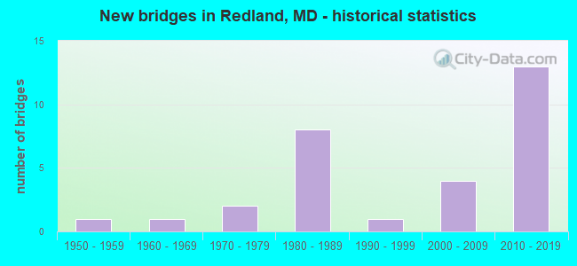
- New bridges - historical statistics
- 11950-1959
- 11960-1969
- 21970-1979
- 81980-1989
- 11990-1999
- 42000-2009
- 132010-2019

- Reconstructed bridges - Historical Statistics
- 11990-1999
- 12000-2009
- 22010-2019


- Bridge Condition - Deck
- 88.9%Good
- 11.1%Satisfactory

- Bridge Condition - Superstructure
- 20.0%Very good
- 65.0%Good
- 5.0%Satisfactory
- 10.0%Fair

- Bridge Condition - Substructure
- 35.0%Very good
- 55.0%Good
- 10.0%Satisfactory

- Bridge Condition - Channel
- 15.4%Very good
- 38.5%Good
- 38.5%Satisfactory
- 7.7%Fair

- Bridge Condition - Culverts
- 62.5%Good
- 25.0%Satisfactory
- 12.5%Fair
Find on map >> Show street view
Structure Number: 10000015001502, Location: 0.34 M E OF OLDE MILL RUN (Lat: 39.137389, Lng: -77.128928), Route carried "on" structure: State highway 115, Year Built: 1970, Status: Open, Structure Length: 1.10m (3.61ft), Average Daily Traffic: 16,981 (year 2013), Truck Traffic: 8%, Average Future Daily Traffic: 21,803 (year 2026), Design Load: HS 20, Features Intersected: ROCK CREEK
Minimum Vertical Clearance: 30+ m (98+ ft), Kilometerpoint: 3.717, Lanes on structure: 2, Owner: State Highway Agency, Approaching Roadway Width: 13.4m (44.0ft), Material/Design: Concrete, Design/Construction: Culvert, Length of Maximum Span: 3.4m (11.2ft)
Condition: Channel: Satisfactory, Culverts: Satisfactory, Operating Rating: 32.7 metric tons, Method Used To Determine Operating Rating: Field evaluation and documented engineering judgment, Inventory Rating: 32.7 metric tons, Method Used To Determine Inventory Rating: Field evaluation and documented engineering judgment, Structural Evaluation: Equal to present minimum criteria, Waterway Adequacy: Better than present minimum criteria, Approach Roadway Alignment: Equal to present desirable criteria, Designated Inspection Frequency: Every 24 months, Inspection Date: August 2020, Deck Structure Type: Concrete Cast-file-Place
Find on map >> Show street view
Structure Number: 10000015014901, Location: 2.43 MI. E. OF I-270 (Lat: 39.130086, Lng: -77.162600), Route carried "on" structure: County highway 212, Year Built: 1989, Status: Open, Structure Length: 6.74m (22.11ft), Average Daily Traffic: 53,010 (year 2009), Truck Traffic: 5%, Average Future Daily Traffic: 28,121 (year 2026), Design Load: HS 20, Features Intersected: IS 370, Facility Carried by Structure: SHADY GROVE ROAD
Minimum Vertical Clearance: 5.18m (16.99ft), Kilometerpoint: 0.000, Lanes on structure: 6, Lanes under structure: 9, Base Highway Network: Yes, Owner: State Highway Agency, Approaching Roadway Width: 33.5m (109.9ft), Skew: 20 degrees, Material/Design: Steel continuous, Design/Construction: Girder and Floorbeam System, Number Of Spans In Main Unit: 2, Length of Maximum Span: 35.4m (116.1ft), Curb or Sidewalk Widths: Left: 1.3m (4.3ft), Right: 1.3m (4.3ft), Curb-To-Curb Width: 34.1m (111.9ft), Out-to-Out Width: 37.4m (122.7ft)
Condition: Deck: Good, Superstructure: Good, Substructure: Good, Operating Rating: 69.4 metric tons, Method Used To Determine Operating Rating: Load Factor (LF), Inventory Rating: 41.3 metric tons, Method Used To Determine Inventory Rating: Load Factor (LF), Structural Evaluation: Better than present minimum criteria, Deck Geometry: Superior to present desirable criteria, Underclear: Equal to present minimum criteria, Approach Roadway Alignment: Equal to present desirable criteria, Designated Inspection Frequency: Every 24 months, Inspection Date: June 2021, Deck Structure Type: Concrete Cast-file-Place, Wearing Surface/Protective System: Wearing Surface: Monolithic Concrete, Deck Protection: Epoxy Coated Reinforcing
Find on map >> Show street view
Structure Number: 100000150150013, Location: 5.84 MILE WEST OF MD 355 (Lat: 39.131450, Lng: -77.170014), Route carried "on" structure: Interstate 370, Year Built: 2010, Status: Open, Structure Length: 2.71m (8.89ft), Average Daily Traffic: 78,741 (year 2009), Truck Traffic: 8%, Average Future Daily Traffic: 71,500 (year 2030), Design Load: HS 25 or greater, Features Intersected: CRABBS BRANCH WAY
Minimum Vertical Clearance: 30+ m (98+ ft), Kilometerpoint: 3.778, Lanes on structure: 4, Lanes under structure: 4, Base Highway Network: Yes, Owner: State Highway Agency, Approaching Roadway Width: 22.6m (74.1ft), Material/Design: Prestressed concrete, Design/Construction: Girder and Floorbeam System, Number Of Spans In Main Unit: 1, Length of Maximum Span: 26.2m (86.0ft), Curb-To-Curb Width: 21.6m (70.9ft), Out-to-Out Width: 22.8m (74.8ft)
Condition: Deck: Good, Superstructure: Good, Substructure: Very good, Operating Rating: 74.8 metric tons, Method Used To Determine Operating Rating: Load Factor (LF), Inventory Rating: 44.9 metric tons, Method Used To Determine Inventory Rating: Load Factor (LF), Structural Evaluation: Better than present minimum criteria, Deck Geometry: Better than present minimum criteria, Underclear: Superior to present desirable criteria, Approach Roadway Alignment: Equal to present desirable criteria, Designated Inspection Frequency: Every 24 months, Inspection Date: May 2021, Deck Structure Type: Concrete Cast-file-Place, Wearing Surface/Protective System: Wearing Surface: Monolithic Concrete, Deck Protection: Epoxy Coated Reinforcing
Find on map >> Show street view
Structure Number: 100000150150014, Location: 5.84 MILE WEST OF MD 97 (Lat: 39.131892, Lng: -77.169981), Route carried "on" structure: Interstate 370, Year Built: 2010, Status: Open, Structure Length: 2.71m (8.89ft), Average Daily Traffic: 78,741 (year 2009), Truck Traffic: 7%, Average Future Daily Traffic: 58,500 (year 2030), Design Load: HS 25 or greater, Features Intersected: CRABBS BRANCH WAY
Minimum Vertical Clearance: 30+ m (98+ ft), Kilometerpoint: 3.778, Lanes on structure: 5, Lanes under structure: 4, Base Highway Network: Yes, Owner: State Highway Agency, Approaching Roadway Width: 24.4m (80.1ft), Material/Design: Prestressed concrete, Design/Construction: Stringer/Multi-beam, Number Of Spans In Main Unit: 1, Length of Maximum Span: 26.2m (86.0ft), Curb-To-Curb Width: 24.4m (80.1ft), Out-to-Out Width: 25.6m (84.0ft)
Condition: Deck: Good, Superstructure: Good, Substructure: Very good, Operating Rating: 74.4 metric tons, Method Used To Determine Operating Rating: Load Factor (LF), Inventory Rating: 44.4 metric tons, Method Used To Determine Inventory Rating: Load Factor (LF), Structural Evaluation: Better than present minimum criteria, Deck Geometry: Equal to present minimum criteria, Underclear: Superior to present desirable criteria, Approach Roadway Alignment: Equal to present desirable criteria, Designated Inspection Frequency: Every 24 months, Inspection Date: May 2021, Deck Structure Type: Concrete Cast-file-Place, Wearing Surface/Protective System: Wearing Surface: Monolithic Concrete, Deck Protection: Epoxy Coated Reinforcing
Find on map >> Show street view
Structure Number: 100000150151013, Location: 0.56 MILE EAST OF MD 355 (Lat: 39.129261, Lng: -77.172139), Route carried "on" structure: Interstate 370, Year Built: 1989, Year Reconstructed: 2010, Status: Open, Structure Length: 4.57m (14.99ft), Average Daily Traffic: 78,741 (year 2009), Truck Traffic: 8%, Average Future Daily Traffic: 71,500 (year 2030), Features Intersected: CSX/MARC
Minimum Vertical Clearance: 30+ m (98+ ft), Kilometerpoint: 3.529, Lanes on structure: 8, Base Highway Network: Yes, Owner: State Highway Agency, Approaching Roadway Width: 46.6m (152.9ft), Skew: 32 degrees, Material/Design: Steel continuous, Design/Construction: Stringer/Multi-beam, Number Of Spans In Main Unit: 2, Length of Maximum Span: 25.9m (85.0ft), Curb-To-Curb Width: 39.4m (129.3ft), Out-to-Out Width: 46.8m (153.5ft)
Condition: Deck: Good, Superstructure: Good, Substructure: Good, Operating Rating: 42.6 metric tons, Method Used To Determine Operating Rating: Load Factor (LF), Inventory Rating: 25.4 metric tons, Method Used To Determine Inventory Rating: Load Factor (LF), Structural Evaluation: Equal to present minimum criteria, Deck Geometry: Superior to present desirable criteria, Underclear: Better than present minimum criteria, Approach Roadway Alignment: Equal to present desirable criteria, Designated Inspection Frequency: Every 24 months, Inspection Date: September 2020, Deck Structure Type: Concrete Cast-file-Place, Wearing Surface/Protective System: Wearing Surface: Monolithic Concrete, Deck Protection: Epoxy Coated Reinforcing
Find on map >> Show street view
Structure Number: 100000150152013, Location: 0.37 MILE EAST OF MD 355 (Lat: 39.127214, Lng: -77.174158), Route carried "on" structure: Interstate 370, Year Built: 1989, Year Reconstructed: 2010, Status: Open, Structure Length: 4.15m (13.62ft), Average Daily Traffic: 78,741 (year 2009), Truck Traffic: 8%, Average Future Daily Traffic: 71,500 (year 2030), Design Load: HS 20, Features Intersected: OAKMONT AVENUE
Minimum Vertical Clearance: 30+ m (98+ ft), Kilometerpoint: 3.250, Lanes on structure: 7, Lanes under structure: 4, Base Highway Network: Yes, Owner: State Highway Agency, Approaching Roadway Width: 42.1m (138.1ft), Skew: 34 degrees, Material/Design: Steel, Design/Construction: Stringer/Multi-beam, Number Of Spans In Main Unit: 1, Length of Maximum Span: 39.0m (128.0ft), Curb-To-Curb Width: 40.0m (131.2ft), Out-to-Out Width: 42.1m (138.1ft)
Condition: Deck: Good, Superstructure: Good, Substructure: Good, Inventory Rating: 66.2 metric tons, Method Used To Determine Inventory Rating: Load Factor (LF), Structural Evaluation: Better than present minimum criteria, Deck Geometry: Superior to present desirable criteria, Underclear: Equal to present minimum criteria, Approach Roadway Alignment: Equal to present desirable criteria, Designated Inspection Frequency: Every 24 months, Inspection Date: October 2021, Deck Structure Type: Concrete Cast-file-Place, Wearing Surface/Protective System: Wearing Surface: Monolithic Concrete, Deck Protection: Epoxy Coated Reinforcing
Find on map >> Show street view
Structure Number: 100000150154013, Location: 1.18 MILE EAST OF IS 270 (Lat: 39.122817, Lng: -77.178428), Route carried "on" structure: Interstate 370, Year Built: 1989, Year Reconstructed: 2011, Status: Open, Structure Length: 4.66m (15.29ft), Average Daily Traffic: 79,062 (year 2010), Truck Traffic: 8%, Average Future Daily Traffic: 96,758 (year 2030), Design Load: HS 20, Features Intersected: MD 355
Minimum Vertical Clearance: 30+ m (98+ ft), Kilometerpoint: 2.590, Lanes on structure: 8, Lanes under structure: 9, Base Highway Network: Yes, Owner: State Highway Agency, Approaching Roadway Width: 46.0m (150.9ft), Skew: 30 degrees, Material/Design: Steel, Design/Construction: Stringer/Multi-beam, Number Of Spans In Main Unit: 1, Length of Maximum Span: 45.1m (148.0ft), Curb-To-Curb Width: 43.6m (143.0ft), Out-to-Out Width: 45.8m (150.3ft)
Condition: Deck: Good, Superstructure: Good, Substructure: Good, Operating Rating: 78.5 metric tons, Method Used To Determine Operating Rating: Load Factor (LF), Inventory Rating: 46.7 metric tons, Method Used To Determine Inventory Rating: Load Factor (LF), Structural Evaluation: Better than present minimum criteria, Deck Geometry: Superior to present desirable criteria, Underclear: Equal to present minimum criteria, Approach Roadway Alignment: Equal to present desirable criteria, Designated Inspection Frequency: Every 24 months, Inspection Date: November 2021, Deck Structure Type: Concrete Cast-file-Place, Wearing Surface/Protective System: Wearing Surface: Monolithic Concrete, Deck Protection: Epoxy Coated Reinforcing
Find on map >> Show street view
Structure Number: 10000015019601, Location: 0.56 MI E OF MD 355 (Lat: 39.131331, Lng: -77.169850), Route carried "on" structure: Ramp Interstate 370, Year Built: 2009, Status: Open, Structure Length: 2.71m (8.89ft), Average Daily Traffic: 3,953 (year 2010), Average Future Daily Traffic: 5,692 (year 2032), Design Load: HS 25 or greater, Features Intersected: CRABBS BRANCH WAY
Minimum Vertical Clearance: 30+ m (98+ ft), Kilometerpoint: 0.336, Lanes on structure: 1, Lanes under structure: 4, Base Highway Network: Yes, Owner: State Highway Agency, Approaching Roadway Width: 11.9m (39.0ft), Material/Design: Prestressed concrete, Design/Construction: Stringer/Multi-beam, Number Of Spans In Main Unit: 1, Length of Maximum Span: 26.2m (86.0ft), Curb-To-Curb Width: 8.2m (26.9ft), Out-to-Out Width: 9.4m (30.8ft)
Condition: Deck: Good, Superstructure: Good, Substructure: Very good, Operating Rating: 85.3 metric tons, Method Used To Determine Operating Rating: Load Factor (LF), Inventory Rating: 41.7 metric tons, Method Used To Determine Inventory Rating: Load Factor (LF), Structural Evaluation: Better than present minimum criteria, Deck Geometry: Superior to present desirable criteria, Underclear: Superior to present desirable criteria, Approach Roadway Alignment: Equal to present desirable criteria, Designated Inspection Frequency: Every 24 months, Inspection Date: May 2021, Deck Structure Type: Concrete Cast-file-Place, Wearing Surface/Protective System: Wearing Surface: Monolithic Concrete, Deck Protection: Epoxy Coated Reinforcing
Find on map >> Show street view
Structure Number: 100000150197013, Location: 5.67 MI WEST OF MD 97 (Lat: 39.133317, Lng: -77.168200), Route carried "on" structure: State highway 370, Year Built: 2010, Status: Open, Structure Length: 3.60m (11.81ft), Average Daily Traffic: 39,531 (year 2010), Truck Traffic: 7%, Average Future Daily Traffic: 71,500 (year 2030), Design Load: HS 25 or greater, Features Intersected: IS-370 RP1, MD200 RP7
Minimum Vertical Clearance: 30+ m (98+ ft), Kilometerpoint: 4.074, Lanes on structure: 3, Lanes under structure: 3, Base Highway Network: Yes, Owner: State Highway Agency, Approaching Roadway Width: 17.1m (56.1ft), Material/Design: Prestressed concrete, Design/Construction: Stringer/Multi-beam, Number Of Spans In Main Unit: 1, Length of Maximum Span: 35.1m (115.2ft), Curb-To-Curb Width: 17.1m (56.1ft), Out-to-Out Width: 18.3m (60.0ft)
Condition: Deck: Good, Superstructure: Very good, Substructure: Very good, Operating Rating: 88.9 metric tons, Method Used To Determine Operating Rating: Load Factor (LF), Inventory Rating: 53.5 metric tons, Method Used To Determine Inventory Rating: Load Factor (LF), Structural Evaluation: Equal to present desirable criteria, Deck Geometry: Equal to present minimum criteria, Underclear: Better than present minimum criteria, Approach Roadway Alignment: Equal to present desirable criteria, Designated Inspection Frequency: Every 24 months, Inspection Date: August 2021, Deck Structure Type: Concrete Cast-file-Place, Wearing Surface/Protective System: Wearing Surface: Monolithic Concrete
Find on map >> Show street view
Structure Number: 100000150197014, Location: 5.67 MI WEST OF MD97 (Lat: 39.133775, Lng: -77.168147), Route carried "on" structure: State highway 370, Year Built: 2010, Status: Open, Structure Length: 3.60m (11.81ft), Average Daily Traffic: 39,531 (year 2010), Truck Traffic: 7%, Average Future Daily Traffic: 58,500 (year 2030), Design Load: HS 25 or greater, Features Intersected: IS-370 RP1, MD200 RP7
Minimum Vertical Clearance: 30+ m (98+ ft), Kilometerpoint: 4.074, Lanes on structure: 5, Lanes under structure: 3, Base Highway Network: Yes, Owner: State Highway Agency, Approaching Roadway Width: 24.7m (81.0ft), Material/Design: Prestressed concrete, Design/Construction: Stringer/Multi-beam, Number Of Spans In Main Unit: 1, Length of Maximum Span: 35.1m (115.2ft), Curb-To-Curb Width: 24.8m (81.4ft), Out-to-Out Width: 26.0m (85.3ft)
Condition: Deck: Good, Superstructure: Very good, Substructure: Very good, Operating Rating: 84.8 metric tons, Method Used To Determine Operating Rating: Load Factor (LF), Inventory Rating: 50.8 metric tons, Method Used To Determine Inventory Rating: Load Factor (LF), Structural Evaluation: Equal to present desirable criteria, Deck Geometry: Better than present minimum criteria, Underclear: Better than present minimum criteria, Approach Roadway Alignment: Equal to present desirable criteria, Designated Inspection Frequency: Every 24 months, Inspection Date: August 2021, Deck Structure Type: Concrete Cast-file-Place, Wearing Surface/Protective System: Wearing Surface: Monolithic Concrete, Deck Protection: Epoxy Coated Reinforcing
Find on map >> Show street view
Structure Number: 200000M-005501, Location: .6 MI W OF MUNCASTER MILL (Lat: 39.127650, Lng: -77.129892), Route carried "on" structure: County highway 138, Year Built: 1965, Status: Open, Structure Length: 1.01m (3.31ft), Average Daily Traffic: 8,652 (year 2021), Truck Traffic: 3%, Average Future Daily Traffic: 9,991 (year 2041), Design Load: HS 20, Features Intersected: ROCK CREEK, Facility Carried by Structure: NEEDWOOD ROAD
Minimum Vertical Clearance: 30+ m (98+ ft), Kilometerpoint: 2.510, Lanes on structure: 2, Owner: County Highway Agency, Approaching Roadway Width: 9.8m (32.2ft), Material/Design: Concrete, Design/Construction: Slab, Number Of Spans In Main Unit: 1, Length of Maximum Span: 9.1m (29.9ft), Curb or Sidewalk Widths: Left: 0.0m, Right: 3.4m (11.2ft), Curb-To-Curb Width: 9.8m (32.2ft), Out-to-Out Width: 14.6m (47.9ft)
Condition: Deck: Satisfactory, Superstructure: Satisfactory, Substructure: Satisfactory, Channel: Good, Operating Rating: 63.5 metric tons, Method Used To Determine Operating Rating: Load Factor (LF), Inventory Rating: 37.6 metric tons, Method Used To Determine Inventory Rating: Load Factor (LF), Structural Evaluation: Equal to present minimum criteria, Deck Geometry: Meets minimum limits, Waterway Adequacy: Better than present minimum criteria, Approach Roadway Alignment: Equal to present desirable criteria, Designated Inspection Frequency: Every 24 months, Inspection Date: July 2021, Deck Structure Type: Concrete Cast-file-Place, Wearing Surface/Protective System: Wearing Surface: Bituminous
Find on map >> Show street view
Structure Number: 200000M-005801, Location: 1 MILE NORTH OF MD 115 (Lat: 39.154203, Lng: -77.131797), Route carried "on" structure: County highway 62, Year Built: 2006, Status: Open, Structure Length: 1.94m (6.36ft), Average Daily Traffic: 14,435 (year 2019), Truck Traffic: 5%, Average Future Daily Traffic: 19,441 (year 2039), Design Load: HS 25 or greater, Features Intersected: ROCK CREEK, Facility Carried by Structure: MUNCASTER ROAD
Minimum Vertical Clearance: 30+ m (98+ ft), Kilometerpoint: 4.087, Lanes on structure: 2, Owner: County Highway Agency, Approaching Roadway Width: 8.8m (28.9ft), Material/Design: Steel, Design/Construction: Stringer/Multi-beam, Number Of Spans In Main Unit: 1, Length of Maximum Span: 17.7m (58.1ft), Curb-To-Curb Width: 10.2m (33.5ft), Out-to-Out Width: 11.2m (36.7ft)
Condition: Deck: Good, Superstructure: Good, Substructure: Good, Channel: Satisfactory, Inventory Rating: 68.0 metric tons, Method Used To Determine Inventory Rating: Load Factor (LF), Structural Evaluation: Better than present minimum criteria, Deck Geometry: Meets minimum limits, Waterway Adequacy: Better than present minimum criteria, Approach Roadway Alignment: Equal to present minimum criteria, Length Of Structure Improvement: 1.98m (6.50ft), Designated Inspection Frequency: Every 24 months, Inspection Date: March 2021, Bridge Improvement Cost: $8,000, Total Project Cost: $8,000, Deck Structure Type: Concrete Cast-file-Place, Wearing Surface/Protective System: Wearing Surface: Monolithic Concrete, Deck Protection: Epoxy Coated Reinforcing
Find on map >> Show street view
Structure Number: 200000M-006901, Location: 1.8 MI NE OF MD 115 (Lat: 39.150775, Lng: -77.103550), Route carried "on" structure: County highway 135, Year Built: 1959, Status: Open, Structure Length: 1.28m (4.20ft), Average Daily Traffic: 19,353 (year 2019), Truck Traffic: 5%, Average Future Daily Traffic: 26,117 (year 2039), Design Load: H 20, Features Intersected: ROCK CREEK NORTH BRANCH, Facility Carried by Structure: BOWIE MILL ROAD
Minimum Vertical Clearance: 30+ m (98+ ft), Kilometerpoint: 2.414, Lanes on structure: 2, Owner: County Highway Agency, Approaching Roadway Width: 7.3m (24.0ft), Skew: 2 degrees, Material/Design: Steel, Design/Construction: Stringer/Multi-beam, Number Of Spans In Main Unit: 1, Length of Maximum Span: 11.9m (39.0ft), Curb-To-Curb Width: 9.8m (32.2ft), Out-to-Out Width: 10.1m (33.1ft)
Condition: Deck: Satisfactory, Superstructure: Fair, Substructure: Satisfactory, Channel: Satisfactory, Inventory Rating: 61.7 metric tons, Method Used To Determine Inventory Rating: Load Factor (LF), Structural Evaluation: Somewhat better than minimum adequacy, Deck Geometry: Meets minimum limits, Waterway Adequacy: Equal to present minimum criteria, Approach Roadway Alignment: Equal to present desirable criteria, Designated Inspection Frequency: Every 24 months, Inspection Date: March 2021, Deck Structure Type: Steel plate, Wearing Surface/Protective System: Wearing Surface: Bituminous
Find on map >> Show street view
Structure Number: 200000M-019302, Location: 1.1 MI SOUTH OF MD 115 (Lat: 39.135478, Lng: -77.156653), Route carried "on" structure: County highway 212, Year Built: 1975, Status: Open, Structure Length: 0.76m (2.49ft), Average Daily Traffic: 62,350 (year 2011), Truck Traffic: 5%, Average Future Daily Traffic: 71,700 (year 2031), Design Load: HS 20, Features Intersected: MILL CREEK, Facility Carried by Structure: SHADY GROVE ROAD
Minimum Vertical Clearance: 30+ m (98+ ft), Kilometerpoint: 8.769, Lanes on structure: 6, Base Highway Network: Yes, Owner: County Highway Agency, Approaching Roadway Width: 30.5m (100.1ft), Skew: 20 degrees, Material/Design: Concrete, Design/Construction: Culvert, Length of Maximum Span: 3.7m (12.1ft), Curb or Sidewalk Widths: Left: 0.0m, Right: 0.2m (0.7ft)
Condition: Channel: Satisfactory, Culverts: Good, Operating Rating: 75.7 metric tons, Method Used To Determine Operating Rating: Load Factor (LF), Inventory Rating: 45.4 metric tons, Method Used To Determine Inventory Rating: Load Factor (LF), Structural Evaluation: Better than present minimum criteria, Waterway Adequacy: Better than present minimum criteria, Approach Roadway Alignment: Equal to present desirable criteria, Designated Inspection Frequency: Every 24 months, Inspection Date: September 2020
Find on map >> Show street view
Structure Number: 200000M-021903, Location: .5 MI W OF SHADY GROVE RD (Lat: 39.142828, Lng: -77.159033), Route carried "on" structure: County highway 5221, Year Built: 1984, Year Reconstructed: 1990, Status: Open, Structure Length: 1.95m (6.40ft), Average Daily Traffic: 31,600 (year 2020), Truck Traffic: 5%, Average Future Daily Traffic: 36,400 (year 2040), Design Load: HS 20, Features Intersected: MILL CREEK, Facility Carried by Structure: MIDCOUNTY HWY & MI
Minimum Vertical Clearance: 30+ m (98+ ft), Kilometerpoint: 0.000, Lanes on structure: 7, Owner: County Highway Agency, Approaching Roadway Width: 31.7m (104.0ft), Skew: 25 degrees, Material/Design: Steel, Design/Construction: Culvert, Length of Maximum Span: 6.4m (21.0ft), Curb or Sidewalk Widths: Left: 0.2m (0.7ft), Right: 0.2m (0.7ft)
Condition: Channel: Satisfactory, Culverts: Fair, Structural Evaluation: Somewhat better than minimum adequacy, Waterway Adequacy: Better than present minimum criteria, Approach Roadway Alignment: Equal to present desirable criteria, Designated Inspection Frequency: Every 24 months, Inspection Date: September 2020
Find on map >> Show street view
Structure Number: 200000M-023801, Location: 0.6 MI NE OF JCT MD 115 (Lat: 39.154531, Lng: -77.141919), Route carried "on" structure: County highway 3283, Year Built: 1994, Status: Open, Structure Length: 1.00m (3.28ft), Average Daily Traffic: 39,290 (year 2019), Truck Traffic: 5%, Average Future Daily Traffic: 53,022 (year 2039), Design Load: HS 20, Features Intersected: TRIBUTARY TO ROCK CREEK, Facility Carried by Structure: AIRPARK ROAD
Minimum Vertical Clearance: 30+ m (98+ ft), Kilometerpoint: 0.000, Lanes on structure: 4, Owner: County Highway Agency, Approaching Roadway Width: 15.5m (50.9ft), Skew: 1 degrees, Material/Design: Steel, Design/Construction: Arch - Deck, Number Of Spans In Main Unit: 1, Length of Maximum Span: 9.8m (32.2ft), Curb or Sidewalk Widths: Left: 0.0m, Right: 2.4m (7.9ft), Curb-To-Curb Width: 14.6m (47.9ft), Out-to-Out Width: 14.9m (48.9ft)
Condition: Superstructure: Fair, Substructure: Good, Channel: Good, Operating Rating: 71.2 metric tons, Method Used To Determine Operating Rating: Load Factor (LF), Inventory Rating: 42.6 metric tons, Method Used To Determine Inventory Rating: Load Factor (LF), Structural Evaluation: Somewhat better than minimum adequacy, Deck Geometry: High priority of replacement, Waterway Adequacy: Equal to present desirable criteria, Approach Roadway Alignment: Equal to present desirable criteria, Designated Inspection Frequency: Every 24 months, Inspection Date: August 2020, Wearing Surface/Protective System: Wearing Surface: Bituminous
Find on map >> Show street view
Structure Number: 200000M-046603, Location: 0.7 MI. S. OF MD 115 (Lat: 39.139983, Lng: -77.150969), Route carried "on" structure: County highway 5122, Year Built: 1980, Status: Open, Structure Length: 0.64m (2.10ft), Average Daily Traffic: 100 (year 2018), Truck Traffic: 1%, Average Future Daily Traffic: 125 (year 2040), Features Intersected: MILL CREEK TRIB, Facility Carried by Structure: FOUNDERS MILL DRIV
Minimum Vertical Clearance: 30+ m (98+ ft), Kilometerpoint: 0.000, Lanes on structure: 2, Owner: County Highway Agency, Approaching Roadway Width: 7.9m (25.9ft), Material/Design: Steel, Design/Construction: Culvert, Length of Maximum Span: 2.7m (8.9ft)
Condition: Channel: Fair, Culverts: Satisfactory, Structural Evaluation: Equal to present minimum criteria, Waterway Adequacy: Better than present minimum criteria, Approach Roadway Alignment: Equal to present desirable criteria, Designated Inspection Frequency: Every 24 months, Inspection Date: January 2020
Find on map >> Show street view
Structure Number: 300000M-V03203, Location: 4.98 mi west of MD 97 (Lat: 39.137736, Lng: -77.156964), Route carried "on" structure: State highway 200, Year Built: 2010, Status: Open, Structure Length: 1.28m (4.20ft), Average Daily Traffic: 42,498 (year 2019), Truck Traffic: 7%, Average Future Daily Traffic: 56,464 (year 2041), Design Load: HS 25 or greater, Features Intersected: Mill Creek
Minimum Vertical Clearance: 30+ m (98+ ft), Kilometerpoint: 0.518, Lanes on structure: 6, Base Highway Network: Yes, Toll: On toll road, Owner: State Toll Authority, Approaching Roadway Width: 17.1m (56.1ft), Material/Design: Concrete, Design/Construction: Culvert, Number Of Spans In Main Unit: 1, Length of Maximum Span: 0.0m
Condition: Channel: Very good, Culverts: Good, Structural Evaluation: Better than present minimum criteria, Waterway Adequacy: Equal to present desirable criteria, Approach Roadway Alignment: Equal to present desirable criteria, Designated Inspection Frequency: Every 24 months, Inspection Date: January 2020
Find on map >> Show street view
Structure Number: 300000M-V033013, Location: 4.86 MI W. OF MD 97 (Lat: 39.137028, Lng: -77.154300), Route carried "on" structure: State highway 200, Year Built: 2010, Status: Open, Structure Length: 4.36m (14.30ft), Average Daily Traffic: 31,652 (year 2019), Truck Traffic: 7%, Average Future Daily Traffic: 61,957 (year 2041), Design Load: HS 25 or greater, Features Intersected: Shady Grove Road
Minimum Vertical Clearance: 30+ m (98+ ft), Kilometerpoint: 0.537, Lanes on structure: 3, Lanes under structure: 6, Base Highway Network: Yes, Toll: On toll road, Owner: State Toll Authority, Approaching Roadway Width: 17.1m (56.1ft), Skew: 12 degrees, Material/Design: Prestressed concrete, Design/Construction: Stringer/Multi-beam, Number Of Spans In Main Unit: 1, Length of Maximum Span: 42.7m (140.1ft), Curb-To-Curb Width: 17.1m (56.1ft), Out-to-Out Width: 18.3m (60.0ft)
Condition: Deck: Good, Superstructure: Good, Substructure: Very good, Operating Rating: 81.6 metric tons, Method Used To Determine Operating Rating: Load Factor (LF), Inventory Rating: 45.4 metric tons, Method Used To Determine Inventory Rating: Load Factor (LF), Structural Evaluation: Better than present minimum criteria, Deck Geometry: Equal to present minimum criteria, Underclear: High priority of corrective action, Approach Roadway Alignment: Equal to present desirable criteria, Designated Inspection Frequency: Every 24 months, Inspection Date: January 2020, Deck Structure Type: Concrete Cast-file-Place, Wearing Surface/Protective System: Wearing Surface: Monolithic Concrete, Deck Protection: Epoxy Coated Reinforcing
Find on map >> Show street view
Structure Number: 300000M-V033014, Location: 4.86 MI W. OF MD 97 (Lat: 39.136978, Lng: -77.155108), Route carried "on" structure: State highway 200, Year Built: 2010, Status: Open, Structure Length: 4.36m (14.30ft), Average Daily Traffic: 30,827 (year 2019), Truck Traffic: 7%, Average Future Daily Traffic: 60,342 (year 2041), Design Load: HS 25 or greater, Features Intersected: Shady Grove Road
Minimum Vertical Clearance: 30+ m (98+ ft), Kilometerpoint: 0.537, Lanes on structure: 3, Lanes under structure: 6, Base Highway Network: Yes, Toll: On toll road, Owner: State Toll Authority, Approaching Roadway Width: 17.1m (56.1ft), Skew: 12 degrees, Material/Design: Prestressed concrete, Design/Construction: Stringer/Multi-beam, Number Of Spans In Main Unit: 1, Length of Maximum Span: 42.7m (140.1ft), Curb-To-Curb Width: 17.1m (56.1ft), Out-to-Out Width: 18.4m (60.4ft)
Condition: Deck: Good, Superstructure: Good, Substructure: Very good, Operating Rating: 75.7 metric tons, Method Used To Determine Operating Rating: Load Factor (LF), Inventory Rating: 40.4 metric tons, Method Used To Determine Inventory Rating: Load Factor (LF), Structural Evaluation: Better than present minimum criteria, Deck Geometry: Equal to present minimum criteria, Underclear: High priority of corrective action, Approach Roadway Alignment: Equal to present desirable criteria, Designated Inspection Frequency: Every 24 months, Inspection Date: January 2020, Deck Structure Type: Concrete Cast-file-Place, Wearing Surface/Protective System: Wearing Surface: Monolithic Concrete, Deck Protection: Epoxy Coated Reinforcing
Find on map >> Show street view
Structure Number: 300000M-V03602, Location: 4.56 mi west of MD 97 (Lat: 39.135803, Lng: -77.149608), Route carried "on" structure: State highway 200, Year Built: 2010, Status: Open, Structure Length: 1.43m (4.69ft), Average Daily Traffic: 42,498 (year 2019), Truck Traffic: 7%, Average Future Daily Traffic: 56,464 (year 2041), Design Load: HS 25 or greater, Features Intersected: Mill Creek Tributary
Minimum Vertical Clearance: 30+ m (98+ ft), Kilometerpoint: 0.587, Lanes on structure: 6, Base Highway Network: Yes, Toll: On toll road, Owner: State Toll Authority, Approaching Roadway Width: 17.1m (56.1ft), Skew: 2 degrees, Material/Design: Concrete, Design/Construction: Culvert, Number Of Spans In Main Unit: 1, Length of Maximum Span: 14.3m (46.9ft)
Condition: Channel: Good, Culverts: Good, Structural Evaluation: Better than present minimum criteria, Waterway Adequacy: Equal to present desirable criteria, Approach Roadway Alignment: Equal to present desirable criteria, Designated Inspection Frequency: Every 24 months, Inspection Date: January 2020
Find on map >> Show street view
Structure Number: 300000M-V03801, Location: 4.38 MI W OF MD 97 (Lat: 39.135425, Lng: -77.146000), Route carried "on" structure: County highway 1936, Year Built: 2009, Status: Open, Structure Length: 8.17m (26.80ft), Average Daily Traffic: 12,649 (year 2019), Truck Traffic: 6%, Average Future Daily Traffic: 15,745 (year 2041), Design Load: HS 25 or greater, Features Intersected: MD 200 (ICC), Facility Carried by Structure: REDLAND ROAD
Minimum Vertical Clearance: 5.18m (16.99ft), Kilometerpoint: 0.615, Lanes on structure: 2, Lanes under structure: 6, Owner: State Toll Authority, Approaching Roadway Width: 10.4m (34.1ft), Skew: 3 degrees, Material/Design: Steel continuous, Design/Construction: Stringer/Multi-beam, Number Of Spans In Main Unit: 2, Length of Maximum Span: 46.9m (153.9ft), Curb or Sidewalk Widths: Left: 1.7m (5.6ft), Right: 1.7m (5.6ft), Curb-To-Curb Width: 10.4m (34.1ft), Out-to-Out Width: 14.9m (48.9ft)
Condition: Deck: Good, Superstructure: Very good, Substructure: Good, Operating Rating: 80.3 metric tons, Method Used To Determine Operating Rating: Load Factor (LF), Inventory Rating: 48.1 metric tons, Method Used To Determine Inventory Rating: Load Factor (LF), Structural Evaluation: Better than present minimum criteria, Deck Geometry: Meets minimum limits, Underclear: High priority of corrective action, Approach Roadway Alignment: Equal to present desirable criteria, Designated Inspection Frequency: Every 24 months, Inspection Date: October 2021, Deck Structure Type: Concrete Cast-file-Place, Wearing Surface/Protective System: Wearing Surface: Monolithic Concrete, Deck Protection: Epoxy Coated Reinforcing
Find on map >> Show street view
Structure Number: 300000M-V04601, Location: 3.63 MI W OF MD 97 (Lat: 39.137692, Lng: -77.133033), Route carried "on" structure: State highway 200, Year Built: 2010, Status: Open, Structure Length: 4.21m (13.81ft), Average Daily Traffic: 1,073 (year 2019), Truck Traffic: 7%, Average Future Daily Traffic: 1,335 (year 2041), Design Load: HS 25 or greater, Features Intersected: MD200 (ICC), Facility Carried by Structure: OLDE MILL RUN ROAD
Minimum Vertical Clearance: 30+ m (98+ ft), Kilometerpoint: 0.735, Lanes on structure: 2, Lanes under structure: 6, Base Highway Network: Yes, Owner: State Toll Authority, Approaching Roadway Width: 10.4m (34.1ft), Material/Design: Prestressed concrete continuous, Design/Construction: Box Beam or Girders - Multiple, Number Of Spans In Main Unit: 2, Length of Maximum Span: 22.6m (74.1ft), Curb-To-Curb Width: 10.4m (34.1ft), Out-to-Out Width: 186.6m (612.2ft)
Condition: Superstructure: Good, Substructure: Good, Inventory Rating: 72.1 metric tons, Method Used To Determine Inventory Rating: Load Factor (LF), Structural Evaluation: Better than present minimum criteria, Deck Geometry: Equal to present minimum criteria, Underclear: High priority of corrective action, Approach Roadway Alignment: Equal to present desirable criteria, Designated Inspection Frequency: Every 24 months, Inspection Date: October 2021, Wearing Surface/Protective System: Wearing Surface: Monolithic Concrete, Deck Protection: Epoxy Coated Reinforcing
Find on map >> Show street view
Structure Number: 300000M-V04901, Location: 3.30 MI W OF MD 97 (Lat: 39.135547, Lng: -77.128522), Route carried "on" structure: State highway 200, Year Built: 2010, Status: Open, Structure Length: 9.30m (30.51ft), Average Daily Traffic: 62,479 (year 2019), Truck Traffic: 3%, Average Future Daily Traffic: 122,299 (year 2041), Design Load: HS 25 or greater, Features Intersected: ROCK CREEK
Minimum Vertical Clearance: 30+ m (98+ ft), Kilometerpoint: 0.079, Lanes on structure: 6, Base Highway Network: Yes, Toll: On toll road, Owner: State Toll Authority, Approaching Roadway Width: 34.1m (111.9ft), Skew: 31 degrees, Material/Design: Prestressed concrete continuous, Design/Construction: Stringer/Multi-beam, Number Of Spans In Main Unit: 3, Length of Maximum Span: 36.6m (120.1ft), Curb-To-Curb Width: 3.6m (11.8ft), Out-to-Out Width: 38.0m (124.7ft)
Condition: Deck: Good, Superstructure: Good, Substructure: Good, Channel: Good, Operating Rating: 58.0 metric tons, Method Used To Determine Operating Rating: Load Factor (LF), Inventory Rating: 34.0 metric tons, Method Used To Determine Inventory Rating: Load Factor (LF), Structural Evaluation: Better than present minimum criteria, Deck Geometry: High priority of replacement, Waterway Adequacy: Equal to present desirable criteria, Approach Roadway Alignment: Equal to present desirable criteria, Designated Inspection Frequency: Every 24 months, Inspection Date: November 2021, Wearing Surface/Protective System: Wearing Surface: Latex Concrete, Deck Protection: Epoxy Coated Reinforcing
Find on map >> Show street view
Structure Number: 300000M-V05301, Location: 2.88 MI W OF MD 97 (Lat: 39.131336, Lng: -77.123864), Route carried "on" structure: County highway 138, Year Built: 2010, Status: Open, Structure Length: 6.77m (22.21ft), Average Daily Traffic: 760 (year 2019), Truck Traffic: 5%, Average Future Daily Traffic: 945 (year 2041), Design Load: HS 25 or greater, Features Intersected: MD 200 (ICC), Facility Carried by Structure: NEEDWOOD ROAD
Minimum Vertical Clearance: 30+ m (98+ ft), Kilometerpoint: 0.856, Lanes on structure: 2, Lanes under structure: 6, Owner: State Toll Authority, Approaching Roadway Width: 10.4m (34.1ft), Material/Design: Steel continuous, Design/Construction: Stringer/Multi-beam, Number Of Spans In Main Unit: 2, Length of Maximum Span: 34.7m (113.8ft), Curb or Sidewalk Widths: Left: 3.0m (9.8ft), Right: 1.7m (5.6ft), Curb-To-Curb Width: 10.4m (34.1ft), Out-to-Out Width: 16.2m (53.1ft)
Condition: Deck: Good, Superstructure: Very good, Substructure: Good, Operating Rating: 88.9 metric tons, Method Used To Determine Operating Rating: Load Factor (LF), Inventory Rating: 53.5 metric tons, Method Used To Determine Inventory Rating: Load Factor (LF), Structural Evaluation: Better than present minimum criteria, Deck Geometry: Equal to present minimum criteria, Underclear: Superior to present desirable criteria, Approach Roadway Alignment: Equal to present desirable criteria, Designated Inspection Frequency: Every 24 months, Inspection Date: November 2021, Deck Structure Type: Concrete Cast-file-Place, Wearing Surface/Protective System: Wearing Surface: Monolithic Concrete, Deck Protection: Epoxy Coated Reinforcing
Find on map >> Show street view
Structure Number: 300000M-V05901, Location: 2.33 MI W OF MD 97 (Lat: 39.126944, Lng: -77.116269), Route carried "on" structure: State highway 115, Year Built: 2010, Status: Open, Structure Length: 7.89m (25.89ft), Average Daily Traffic: 19,690 (year 2019), Truck Traffic: 1%, Average Future Daily Traffic: 38,542 (year 2041), Design Load: HS 25 or greater, Features Intersected: MD 200 (ICC), Facility Carried by Structure: MUNCASTER MILL RD
Minimum Vertical Clearance: 30+ m (98+ ft), Kilometerpoint: 0.944, Lanes on structure: 2, Lanes under structure: 6, Owner: State Toll Authority, Approaching Roadway Width: 9.8m (32.2ft), Skew: 1 degrees, Material/Design: Steel continuous, Design/Construction: Stringer/Multi-beam, Number Of Spans In Main Unit: 2, Length of Maximum Span: 39.6m (129.9ft), Curb or Sidewalk Widths: Left: 1.7m (5.6ft), Right: 0.3m (1.0ft), Curb-To-Curb Width: 9.8m (32.2ft), Out-to-Out Width: 15.6m (51.2ft)
Condition: Deck: Good, Superstructure: Good, Substructure: Good, Inventory Rating: 59.0 metric tons, Method Used To Determine Inventory Rating: Load Factor (LF), Structural Evaluation: Better than present minimum criteria, Deck Geometry: Meets minimum limits, Underclear: High priority of corrective action, Approach Roadway Alignment: Equal to present desirable criteria, Designated Inspection Frequency: Every 24 months, Inspection Date: September 2021, Deck Structure Type: Concrete Cast-file-Place, Wearing Surface/Protective System: Wearing Surface: Monolithic Concrete, Deck Protection: Epoxy Coated Reinforcing
Find on map >> Show street view
Structure Number: 300000P-V18302, Location: .7 MI E OLD GUNPOWDER RD (Lat: 39.074575, Lng: -76.908856), Route carried "on" structure: State highway 200, Year Built: 2010, Status: Open, Structure Length: 1.04m (3.41ft), Average Daily Traffic: 13,543 (year 2019), Truck Traffic: 7%, Average Future Daily Traffic: 17,994 (year 2041), Design Load: HS 25 or greater, Features Intersected: Unnamed Stream
Minimum Vertical Clearance: 30+ m (98+ ft), Kilometerpoint: 2.944, Lanes on structure: 4, Base Highway Network: Yes, Toll: On toll road, Owner: State Toll Authority, Approaching Roadway Width: 11.0m (36.1ft), Skew: 2 degrees, Material/Design: Concrete, Design/Construction: Culvert, Number Of Spans In Main Unit: 3, Length of Maximum Span: 3.0m (9.8ft)
Condition: Channel: Good, Culverts: Good, Structural Evaluation: Better than present minimum criteria, Waterway Adequacy: Superior to present desirable criteria, Approach Roadway Alignment: Equal to present desirable criteria, Designated Inspection Frequency: Every 24 months, Inspection Date: November 2021
Find on map >> Show street view
Structure Number: 300000P-V18402, Location: .7 MI E OLD GUNPOWDER RD (Lat: 0.651178, Lng: -1.281750), Route carried "on" structure: State highway 200, Year Built: 2009, Status: Open, Structure Length: 1.04m (3.41ft), Average Daily Traffic: 3,061 (year 2016), Truck Traffic: 7%, Average Future Daily Traffic: 3,817 (year 2035), Design Load: HS 25 or greater, Features Intersected: Unnamed Stream
Minimum Vertical Clearance: 30+ m (98+ ft), Kilometerpoint: 2.961, Lanes on structure: 2, Base Highway Network: Yes, Toll: On toll road, Owner: State Toll Authority, Approaching Roadway Width: 12.8m (42.0ft), Material/Design: Concrete, Design/Construction: Culvert, Number Of Spans In Main Unit: 3, Length of Maximum Span: 3.0m (9.8ft)
Condition: Channel: Very good, Culverts: Good, Structural Evaluation: Better than present minimum criteria, Waterway Adequacy: Superior to present desirable criteria, Approach Roadway Alignment: Equal to present desirable criteria, Designated Inspection Frequency: Every 24 months, Inspection Date: November 2021
Find on map >> Show street view
Structure Number: 10000015014901, Location: 0.48 m e of br no 1515000 (Lat: 39.130086, Lng: -77.162600), Route carried "under" structure: Interstate 370, Year Built: 1989, Structure Length: 0. m, Average Daily Traffic: 78,741 (year 2009), Truck Traffic: 8%, Features Intersected: IS 370, Facility Carried by Structure: SHADY GROVE ROAD
Minimum Vertical Clearance: 5.18m (16.99ft), Kilometerpoint: 4.602, Lanes on structure: 6, Lanes under structure: 4, Material/Design: Steel, Design/Construction: Girder and Floorbeam System, Length of Maximum Span: 35.4m (116.1ft)
Find on map >> Show street view
Structure Number: 100000150154013, Location: .06 M N OF SHADY GROVE RD (Lat: 39.122817, Lng: -77.178428), Route carried "under" structure: State highway 355, Year Built: 1989, Structure Length: 0. m, Average Daily Traffic: 34,970 (year 2009), Truck Traffic: 8%, Features Intersected: MD 355, Facility Carried by Structure: IS 370
Minimum Vertical Clearance: 5.18m (16.99ft), Kilometerpoint: 20.402, Lanes on structure: 2, Lanes under structure: 9, Material/Design: Steel, Design/Construction: Stringer/Multi-beam, Length of Maximum Span: 45.1m (148.0ft)