Bridge Statistics for Raytown, Missouri (MO)
Condition, Traffic, Stress, Structural Evaluation, Project Costs
- National Bridge Inventory (NBI) Statistics
- 22Number of bridges
- 184ft / 55.7mTotal length
- $1,455,000Total costs
- 476,693Total average daily traffic
- 30,847Total average daily truck traffic
- National Bridge Inventory (NBI) Registered Bridges for Raytown
- No street view available for this location
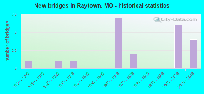
- New bridges - historical statistics
- 11900-1909
- 11920-1929
- 11930-1939
- 71960-1969
- 21970-1979
- 62000-2009
- 42010-2019
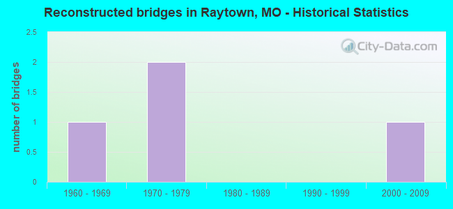
- Reconstructed bridges - Historical Statistics
- 11960-1969
- 21970-1979
- 01980-1989
- 01990-1999
- 12000-2009

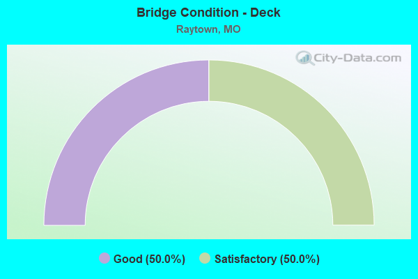
- Bridge Condition - Deck
- 50.0%Good
- 50.0%Satisfactory
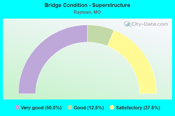
- Bridge Condition - Superstructure
- 50.0%Very good
- 12.5%Good
- 37.5%Satisfactory
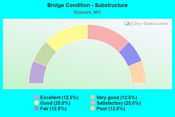
- Bridge Condition - Substructure
- 12.5%Excellent
- 12.5%Very good
- 25.0%Good
- 25.0%Satisfactory
- 12.5%Fair
- 12.5%Poor
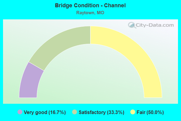
- Bridge Condition - Channel
- 16.7%Very good
- 33.3%Satisfactory
- 50.0%Fair
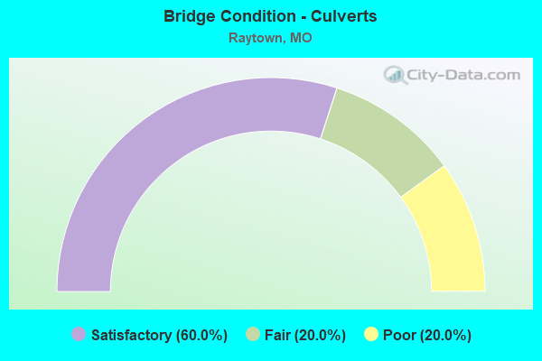
- Bridge Condition - Culverts
- 60.0%Satisfactory
- 20.0%Fair
- 20.0%Poor
Find on map >> Show street view
Structure Number: 22552, Location: S 32 T 49 N R 32 W (Lat: 39.026889, Lng: -94.469542), Route carried "on" structure: City street , Year Built: 1972, Status: Open, Structure Length: 1.43m (4.69ft), Average Daily Traffic: 13,750 (year 2021), Truck Traffic: 20%, Average Future Daily Traffic: 17,875 (year 2041), Design Load: H 20, Features Intersected: DRAIN CR, Facility Carried by Structure: RAYTOWN RD
Minimum Vertical Clearance: 30+ m (98+ ft), Kilometerpoint: 0.000, Lanes on structure: 4, Owner: City or Municipal Highway Agency, Approaching Roadway Width: 15.2m (49.9ft), Material/Design: Concrete, Design/Construction: Culvert, Number Of Spans In Main Unit: 3, Length of Maximum Span: 3.0m (9.8ft)
Condition: Channel: Fair, Culverts: Satisfactory, Operating Rating: 49.5 metric tons, Method Used To Determine Operating Rating: Allowable Stress (AS), Inventory Rating: 22.5 metric tons, Method Used To Determine Inventory Rating: Allowable Stress (AS), Structural Evaluation: Somewhat better than minimum adequacy, Waterway Adequacy: Equal to present minimum criteria, Approach Roadway Alignment: Equal to present desirable criteria, Designated Inspection Frequency: Every 24 months, Inspection Date: Febuary 2021
Find on map >> Show street view
Structure Number: 22553, Location: S 9 T 48 N R 32 W (Lat: 38.995381, Lng: -94.446389), Route carried "on" structure: City street , Year Built: 1973, Status: Open, Structure Length: 0.73m (2.40ft), Average Daily Traffic: 3,000 (year 2021), Truck Traffic: 10%, Average Future Daily Traffic: 3,900 (year 2041), Features Intersected: STREAM, Facility Carried by Structure: WOODSON RD
Minimum Vertical Clearance: 30+ m (98+ ft), Kilometerpoint: 0.161, Lanes on structure: 2, Owner: City or Municipal Highway Agency, Approaching Roadway Width: 8.5m (27.9ft), Material/Design: Concrete, Design/Construction: Culvert, Number Of Spans In Main Unit: 2, Length of Maximum Span: 3.4m (11.2ft)
Condition: Channel: Satisfactory, Culverts: Fair, Operating Rating: 49.5 metric tons, Method Used To Determine Operating Rating: Allowable Stress (AS), Inventory Rating: 16.2 metric tons, Method Used To Determine Inventory Rating: Allowable Stress (AS), Structural Evaluation: Meets minimum limits, Waterway Adequacy: Equal to present minimum criteria, Approach Roadway Alignment: Equal to present desirable criteria, Designated Inspection Frequency: Every 24 months, Inspection Date: Febuary 2021
Find on map >> Show street view
Structure Number: 22555, Location: S 5 T 48 N R 32 W (Lat: 39.005675, Lng: -94.463553), Route carried "on" structure: City street , Year Built: 1920, Year Reconstructed: 2005, Status: Posted for load, Structure Length: 5.97m (19.59ft), Average Daily Traffic: 9,650 (year 2021), Truck Traffic: 15%, Average Future Daily Traffic: 12,545 (year 2041), Features Intersected: UP RR, Facility Carried by Structure: RAYTOWN RD
Minimum Vertical Clearance: 30+ m (98+ ft), Kilometerpoint: 0.161, Lanes on structure: 1, Owner: City or Municipal Highway Agency, Approaching Roadway Width: 7.3m (24.0ft), Material/Design: Steel, Design/Construction: Stringer/Multi-beam, Number Of Spans In Main Unit: 1, Number Of Approach Spans: 10, Length of Maximum Span: 10.4m (34.1ft), Curb-To-Curb Width: 6.5m (21.3ft), Out-to-Out Width: 6.6m (21.7ft)
Condition: Deck: Satisfactory, Superstructure: Satisfactory, Substructure: Poor, Operating Rating: 16.2 metric tons, Method Used To Determine Operating Rating: Field evaluation and documented engineering judgment, Inventory Rating: 9.9 metric tons, Method Used To Determine Inventory Rating: Field evaluation and documented engineering judgment, Structural Evaluation: High priority of replacement, Deck Geometry: High priority of replacement, Underclear: Better than present minimum criteria, Approach Roadway Alignment: Equal to present minimum criteria, Bridge Posting: Required (Relationship of Operating Rating to Maximum Legal Load: 30.0 - 39.9% below), Length Of Structure Improvement: 0.70m (2.30ft), Designated Inspection Frequency: Every 24 months, Inspection Date: Febuary 2021, Bridge Improvement Cost: $800,000, Roadway Improvement Cost: $80,000, Total Project Cost: $1,200,000 ( Estimate for 2022), Deck Structure Type: Wood or Timber, Wearing Surface/Protective System: Wearing Surface: Bituminous
Find on map >> Show street view
Structure Number: 22556, Location: S 20 T 48 N R 32 W (Lat: 38.970394, Lng: -94.465147), Route carried "on" structure: City street , Year Built: 1900, Status: Open, Structure Length: 0.82m (2.69ft), Average Daily Traffic: 11,400 (year 2021), Truck Traffic: 20%, Average Future Daily Traffic: 14,820 (year 2041), Features Intersected: STREAM, Facility Carried by Structure: RAYTOWN RD
Minimum Vertical Clearance: 30+ m (98+ ft), Kilometerpoint: 0.000, Lanes on structure: 4, Owner: City or Municipal Highway Agency, Approaching Roadway Width: 15.2m (49.9ft), Material/Design: Concrete, Design/Construction: Culvert, Number Of Spans In Main Unit: 2, Length of Maximum Span: 3.7m (12.1ft)
Condition: Channel: Satisfactory, Culverts: Satisfactory, Operating Rating: 49.5 metric tons, Method Used To Determine Operating Rating: Allowable Stress (AS), Inventory Rating: 22.5 metric tons, Method Used To Determine Inventory Rating: Allowable Stress (AS), Structural Evaluation: Somewhat better than minimum adequacy, Waterway Adequacy: Superior to present desirable criteria, Approach Roadway Alignment: Equal to present desirable criteria, Designated Inspection Frequency: Every 24 months, Inspection Date: Febuary 2021
Find on map >> Show street view
Structure Number: 29146, Location: S 22 T 49 N R 32 W (Lat: 39.045581, Lng: -94.439006), Route carried "on" structure: City street , Year Built: 2002, Status: Open, Structure Length: 7.19m (23.59ft), Average Daily Traffic: 13,713 (year 2021), Truck Traffic: 5%, Average Future Daily Traffic: 18,513 (year 2041), Design Load: HS 20, Features Intersected: US 40, Facility Carried by Structure: BLUE RIDGE BLVD S
Minimum Vertical Clearance: 30+ m (98+ ft), Kilometerpoint: 9.444, Lanes on structure: 2, Lanes under structure: 4, Owner: State Highway Agency, Approaching Roadway Width: 12.2m (40.0ft), Skew: 3 degrees, Material/Design: Steel continuous, Design/Construction: Stringer/Multi-beam, Number Of Spans In Main Unit: 3, Length of Maximum Span: 27.1m (88.9ft), Curb-To-Curb Width: 12.2m (40.0ft), Out-to-Out Width: 13.0m (42.7ft)
Condition: Deck: Satisfactory, Superstructure: Very good, Substructure: Satisfactory, Operating Rating: 95.4 metric tons, Method Used To Determine Operating Rating: Load Factor (LF), Inventory Rating: 57.6 metric tons, Method Used To Determine Inventory Rating: Load Factor (LF), Structural Evaluation: Equal to present minimum criteria, Deck Geometry: Somewhat better than minimum adequacy, Underclear: Somewhat better than minimum adequacy, Approach Roadway Alignment: Equal to present desirable criteria, Designated Inspection Frequency: Every 24 months, Inspection Date: September 2021, Deck Structure Type: Concrete Cast-file-Place, Wearing Surface/Protective System: Wearing Surface: Monolithic Concrete, Deck Protection: Epoxy Coated Reinforcing
Find on map >> Show street view
Structure Number: 29414, Location: S 6 T 48 N R 32 W (Lat: 39.009892, Lng: -94.489606), Route carried "on" structure: State highway 350, Year Built: 2003, Status: Open, Structure Length: 8.05m (26.41ft), Average Daily Traffic: 18,914 (year 2021), Truck Traffic: 5%, Average Future Daily Traffic: 25,534 (year 2041), Design Load: HS 20+Mod, Features Intersected: CST E 63RD ST
Minimum Vertical Clearance: 30+ m (98+ ft), Kilometerpoint: 2.068, Lanes on structure: 2, Lanes under structure: 6, Base Highway Network: Yes, Owner: State Highway Agency, Approaching Roadway Width: 11.6m (38.1ft), Skew: 4 degrees, Material/Design: Steel continuous, Design/Construction: Stringer/Multi-beam, Number Of Spans In Main Unit: 4, Length of Maximum Span: 22.3m (73.2ft), Curb-To-Curb Width: 11.6m (38.1ft), Out-to-Out Width: 12.4m (40.7ft)
Condition: Deck: Good, Superstructure: Very good, Substructure: Good, Operating Rating: 82.8 metric tons, Method Used To Determine Operating Rating: Load Factor (LF), Inventory Rating: 49.5 metric tons, Method Used To Determine Inventory Rating: Load Factor (LF), Structural Evaluation: Better than present minimum criteria, Deck Geometry: Equal to present minimum criteria, Underclear: Somewhat better than minimum adequacy, Approach Roadway Alignment: Equal to present desirable criteria, Designated Inspection Frequency: Every 24 months, Inspection Date: September 2021, Deck Structure Type: Concrete Cast-file-Place, Wearing Surface/Protective System: Wearing Surface: Monolithic Concrete, Deck Protection: Epoxy Coated Reinforcing
Find on map >> Show street view
Structure Number: 29415, Location: S 6 T 48 N R 32 W (Lat: 39.009869, Lng: -94.489236), Route carried "on" structure: State highway 350, Year Built: 2003, Status: Open, Structure Length: 8.05m (26.41ft), Average Daily Traffic: 14,422 (year 2021), Truck Traffic: 6%, Average Future Daily Traffic: 19,470 (year 2041), Design Load: HS 20+Mod, Features Intersected: CST E 63RD ST
Minimum Vertical Clearance: 30+ m (98+ ft), Kilometerpoint: 11.520, Lanes on structure: 2, Lanes under structure: 6, Base Highway Network: Yes, Owner: State Highway Agency, Approaching Roadway Width: 11.6m (38.1ft), Skew: 4 degrees, Material/Design: Steel continuous, Design/Construction: Stringer/Multi-beam, Number Of Spans In Main Unit: 4, Length of Maximum Span: 22.3m (73.2ft), Curb-To-Curb Width: 11.6m (38.1ft), Out-to-Out Width: 12.4m (40.7ft)
Condition: Deck: Good, Superstructure: Very good, Substructure: Good, Operating Rating: 85.5 metric tons, Method Used To Determine Operating Rating: Load Factor (LF), Inventory Rating: 51.3 metric tons, Method Used To Determine Inventory Rating: Load Factor (LF), Structural Evaluation: Better than present minimum criteria, Deck Geometry: Equal to present minimum criteria, Underclear: Somewhat better than minimum adequacy, Approach Roadway Alignment: Equal to present desirable criteria, Designated Inspection Frequency: Every 24 months, Inspection Date: September 2021, Deck Structure Type: Concrete Cast-file-Place, Wearing Surface/Protective System: Wearing Surface: Monolithic Concrete, Deck Protection: Epoxy Coated Reinforcing
Find on map >> Show street view
Structure Number: 33547, Location: S 5 T 48 N R 32 W (Lat: 39.008533, Lng: -94.465400), Route carried "on" structure: City street , Year Built: 2010, Status: Open, Structure Length: 4.08m (13.39ft), Average Daily Traffic: 15,100 (year 2021), Truck Traffic: 10%, Average Future Daily Traffic: 19,630 (year 2041), Features Intersected: UP RR, Facility Carried by Structure: 63RD ST
Minimum Vertical Clearance: 30+ m (98+ ft), Kilometerpoint: 0.000, Lanes on structure: 5, Owner: City or Municipal Highway Agency, Approaching Roadway Width: 18.3m (60.0ft), Skew: 2 degrees, Material/Design: Steel, Design/Construction: Stringer/Multi-beam, Number Of Spans In Main Unit: 1, Length of Maximum Span: 39.9m (130.9ft), Curb-To-Curb Width: 19.6m (64.3ft), Out-to-Out Width: 24.2m (79.4ft)
Condition: Deck: Good, Superstructure: Very good, Substructure: Excellent, Operating Rating: 65.7 metric tons, Method Used To Determine Operating Rating: Load Factor (LF), Inventory Rating: 38.7 metric tons, Method Used To Determine Inventory Rating: Load Factor (LF), Structural Evaluation: Equal to present desirable criteria, Deck Geometry: Meets minimum limits, Approach Roadway Alignment: Equal to present desirable criteria, Designated Inspection Frequency: Every 24 months, Inspection Date: Febuary 2021, Deck Structure Type: Concrete Precast Panels
Find on map >> Show street view
Structure Number: 35565, Location: S 16 T 48 N R 32 W (Lat: 38.972236, Lng: -94.461517), Route carried "on" structure: City street , Year Built: 2017, Status: Open, Structure Length: 4.04m (13.25ft), Average Daily Traffic: 3,900 (year 2021), Truck Traffic: 10%, Average Future Daily Traffic: 5,070 (year 2041), Design Load: HS 20, Features Intersected: BR OF WHITE OAK, Facility Carried by Structure: 83RD ST
Minimum Vertical Clearance: 30+ m (98+ ft), Kilometerpoint: 0.000, Lanes on structure: 2, Owner: City or Municipal Highway Agency, Approaching Roadway Width: 11.4m (37.4ft), Material/Design: Prestressed concrete, Design/Construction: Stringer/Multi-beam, Number Of Spans In Main Unit: 2, Length of Maximum Span: 20.2m (66.3ft), Curb-To-Curb Width: 11.4m (37.4ft), Out-to-Out Width: 13.8m (45.3ft)
Condition: Deck: Good, Superstructure: Good, Substructure: Very good, Channel: Very good, Operating Rating: 54.0 metric tons, Method Used To Determine Operating Rating: Load Factor (LF), Inventory Rating: 32.4 metric tons, Method Used To Determine Inventory Rating: Load Factor (LF), Structural Evaluation: Better than present minimum criteria, Deck Geometry: Somewhat better than minimum adequacy, Waterway Adequacy: Superior to present desirable criteria, Approach Roadway Alignment: Equal to present desirable criteria, Designated Inspection Frequency: Every 24 months, Inspection Date: Febuary 2021, Deck Structure Type: Concrete Precast Panels, Wearing Surface/Protective System: Wearing Surface: Monolithic Concrete, Deck Protection: Epoxy Coated Reinforcing
Find on map >> Show street view
Structure Number: 4843, Location: S 26 T 48 N R 33 W (Lat: 38.955253, Lng: -94.540458), Route carried "on" structure: US 71, Year Built: 1961, Year Reconstructed: 1972, Status: Open, Structure Length: 1.43m (4.69ft), Average Daily Traffic: 80,943 (year 2021), Truck Traffic: 6%, Average Future Daily Traffic: 109,273 (year 2041), Design Load: H 20, Features Intersected: LIT BLUE RVR
Minimum Vertical Clearance: 30+ m (98+ ft), Kilometerpoint: 207.139, Lanes on structure: 8, Base Highway Network: Yes, Owner: State Highway Agency, Approaching Roadway Width: 13.4m (44.0ft), Skew: 4 degrees, Material/Design: Concrete continuous, Design/Construction: Culvert, Number Of Spans In Main Unit: 2, Length of Maximum Span: 4.6m (15.1ft)
Condition: Channel: Fair, Culverts: Satisfactory, Operating Rating: 72.0 metric tons, Method Used To Determine Operating Rating: Field evaluation and documented engineering judgment, Inventory Rating: 43.2 metric tons, Method Used To Determine Inventory Rating: Field evaluation and documented engineering judgment, Structural Evaluation: Equal to present minimum criteria, Waterway Adequacy: Equal to present desirable criteria, Approach Roadway Alignment: Equal to present desirable criteria, Designated Inspection Frequency: Every 24 months, Inspection Date: November 2021, Wearing Surface/Protective System: Wearing Surface: Other
Find on map >> Show street view
Structure Number: 6547, Location: S 26 T 48 N R 33 W (Lat: 38.953794, Lng: -94.540119), Route carried "on" structure: US 71, Year Built: 1961, Year Reconstructed: 1984, Status: Open, Structure Length: 6.60m (21.65ft), Average Daily Traffic: 41,659 (year 2021), Truck Traffic: 6%, Average Future Daily Traffic: 56,240 (year 2041), Design Load: HS 20, Features Intersected: RT W
Minimum Vertical Clearance: 30+ m (98+ ft), Kilometerpoint: 207.289, Lanes on structure: 2, Lanes under structure: 6, Base Highway Network: Yes, Owner: State Highway Agency, Approaching Roadway Width: 11.6m (38.1ft), Skew: 1 degrees, Material/Design: Concrete continuous, Design/Construction: Slab, Number Of Spans In Main Unit: 4, Length of Maximum Span: 17.1m (56.1ft), Curb-To-Curb Width: 9.1m (29.9ft), Out-to-Out Width: 10.6m (34.8ft)
Condition: Deck: Satisfactory, Superstructure: Satisfactory, Substructure: Fair, Operating Rating: 58.5 metric tons, Method Used To Determine Operating Rating: Load Factor (LF), Inventory Rating: 35.1 metric tons, Method Used To Determine Inventory Rating: Load Factor (LF), Structural Evaluation: Somewhat better than minimum adequacy, Deck Geometry: Meets minimum limits, Underclear: Somewhat better than minimum adequacy, Approach Roadway Alignment: Equal to present desirable criteria, Designated Inspection Frequency: Every 24 months, Inspection Date: October 2021, Deck Structure Type: Concrete Cast-file-Place, Wearing Surface/Protective System: Wearing Surface: Low Slump Concrete
Find on map >> Show street view
Structure Number: 6682, Location: S 26 T 48 N R 33 W (Lat: 38.953678, Lng: -94.539881), Route carried "on" structure: US 71, Year Built: 1961, Year Reconstructed: 1984, Status: Open, Structure Length: 6.60m (21.65ft), Average Daily Traffic: 36,009 (year 2021), Truck Traffic: 6%, Average Future Daily Traffic: 48,612 (year 2041), Design Load: HS 20, Features Intersected: RT W
Minimum Vertical Clearance: 30+ m (98+ ft), Kilometerpoint: 303.418, Lanes on structure: 2, Lanes under structure: 6, Base Highway Network: Yes, Owner: State Highway Agency, Approaching Roadway Width: 11.6m (38.1ft), Skew: 1 degrees, Material/Design: Concrete continuous, Design/Construction: Slab, Number Of Spans In Main Unit: 4, Length of Maximum Span: 17.1m (56.1ft), Curb-To-Curb Width: 9.1m (29.9ft), Out-to-Out Width: 10.6m (34.8ft)
Condition: Deck: Satisfactory, Superstructure: Satisfactory, Substructure: Satisfactory, Operating Rating: 58.5 metric tons, Method Used To Determine Operating Rating: Load Factor (LF), Inventory Rating: 35.1 metric tons, Method Used To Determine Inventory Rating: Load Factor (LF), Structural Evaluation: Equal to present minimum criteria, Deck Geometry: Meets minimum limits, Underclear: Somewhat better than minimum adequacy, Approach Roadway Alignment: Equal to present desirable criteria, Designated Inspection Frequency: Every 24 months, Inspection Date: October 2021, Deck Structure Type: Concrete Cast-file-Place, Wearing Surface/Protective System: Wearing Surface: Low Slump Concrete
Find on map >> Show street view
Structure Number: 9944, Location: S 11 T 48 N R 32 W (Lat: 39.028186, Lng: -94.414142), Route carried "on" structure: State highway V, Year Built: 1931, Status: Open, Structure Length: 0.68m (2.23ft), Average Daily Traffic: 9,729 (year 2021), Truck Traffic: 3%, Average Future Daily Traffic: 13,134 (year 2041), Design Load: H 15, Features Intersected: BR LIT BLUE RVR
Minimum Vertical Clearance: 30+ m (98+ ft), Kilometerpoint: 0.863, Lanes on structure: 2, Base Highway Network: Yes, Owner: State Highway Agency, Approaching Roadway Width: 7.3m (24.0ft), Skew: 2 degrees, Material/Design: Concrete continuous, Design/Construction: Culvert, Number Of Spans In Main Unit: 2, Length of Maximum Span: 3.0m (9.8ft)
Condition: Channel: Fair, Culverts: Poor, Operating Rating: 99.0 metric tons, Method Used To Determine Operating Rating: Load Factor (LF), Inventory Rating: 59.4 metric tons, Method Used To Determine Inventory Rating: Load Factor (LF), Structural Evaluation: Meets minimum limits, Waterway Adequacy: Equal to present desirable criteria, Approach Roadway Alignment: Equal to present minimum criteria, Length Of Structure Improvement: 0.13m (0.43ft), Designated Inspection Frequency: Every 24 months, Inspection Date: November 2021, Bridge Improvement Cost: $170,000, Roadway Improvement Cost: $17,000, Total Project Cost: $255,000 ( Estimate for 2022)
Find on map >> Show street view
Structure Number: 29146, Location: S 22 T 49 N R 32 W (Lat: 39.045581, Lng: -94.439006), Route carried "under" structure: US 40, Year Built: 2002, Structure Length: 0. m, Average Daily Traffic: 16,512 (year 2021), Truck Traffic: 2%, Features Intersected: US 40, Facility Carried by Structure: BLUE RIDGE BLVD S
Minimum Vertical Clearance: 5.08m (16.67ft), Kilometerpoint: 18.800, Lanes on structure: 2, Lanes under structure: 4, Material/Design: Steel continuous, Design/Construction: Stringer/Multi-beam, Length of Maximum Span: 27.1m (88.9ft)
Find on map >> Show street view
Structure Number: 29414, Location: S 6 T 48 N R 32 W (Lat: 39.009892, Lng: -94.489606), Route carried "under" structure: City street , Year Built: 2003, Structure Length: 0. m, Average Daily Traffic: 18,418 (year 2021), Truck Traffic: 5%, Features Intersected: CST E 63RD ST, Facility Carried by Structure: MO 350 E
Minimum Vertical Clearance: 5.26m (17.26ft), Kilometerpoint: 1.770, Lanes on structure: 2, Lanes under structure: 6, Material/Design: Steel continuous, Design/Construction: Stringer/Multi-beam, Length of Maximum Span: 22.3m (73.2ft)
Find on map >> Show street view
Structure Number: 29415, Location: S 6 T 48 N R 32 W (Lat: 39.009869, Lng: -94.489236), Route carried "under" structure: City street , Year Built: 2003, Structure Length: 0. m, Average Daily Traffic: 18,418 (year 2021), Truck Traffic: 5%, Features Intersected: CST E 63RD ST, Facility Carried by Structure: MO 350 W
Minimum Vertical Clearance: 5.10m (16.73ft), Kilometerpoint: 1.770, Lanes on structure: 2, Lanes under structure: 6, Material/Design: Steel continuous, Design/Construction: Stringer/Multi-beam, Length of Maximum Span: 22.3m (73.2ft)
Find on map >> Show street view
Structure Number: 33692, Location: S 8 T 48 N R 32 W (Lat: 39.002472, Lng: -94.484189), Route carried "under" structure: State highway 350, Year Built: 2011, Structure Length: 0. m, Average Daily Traffic: 14,422 (year 2021), Truck Traffic: 6%, Features Intersected: MO 350, Facility Carried by Structure: E 67TH ST E
Minimum Vertical Clearance: 4.60m (15.09ft), Kilometerpoint: 10.599, Lanes on structure: 2, Lanes under structure: 3, Material/Design: Prestressed concrete, Design/Construction: Box Beam or Girders - Multiple, Length of Maximum Span: 25.9m (85.0ft)
Find on map >> Show street view
Structure Number: 33692, Location: S 8 T 48 N R 32 W (Lat: 39.002472, Lng: -94.484189), Route carried "under" structure: State highway 350, Year Built: 2011, Structure Length: 0. m, Average Daily Traffic: 14,444 (year 2021), Truck Traffic: 5%, Features Intersected: MO 350, Facility Carried by Structure: E 67TH ST E
Minimum Vertical Clearance: 4.55m (14.93ft), Kilometerpoint: 3.074, Lanes on structure: 2, Lanes under structure: 2, Material/Design: Prestressed concrete, Design/Construction: Box Beam or Girders - Multiple, Length of Maximum Span: 25.9m (85.0ft)
Find on map >> Show street view
Structure Number: 6547, Location: S 26 T 48 N R 33 W (Lat: 38.953794, Lng: -94.540119), Route carried "under" structure: State highway W, Year Built: 1961, Structure Length: 0. m, Average Daily Traffic: 7,598 (year 2021), Truck Traffic: 5%, Features Intersected: RT W, Facility Carried by Structure: US 71 S
Minimum Vertical Clearance: 4.65m (15.26ft), Kilometerpoint: 0.980, Lanes on structure: 2, Lanes under structure: 3, Material/Design: Concrete continuous, Design/Construction: Slab, Length of Maximum Span: 17.1m (56.1ft)
Find on map >> Show street view
Structure Number: 6547, Location: S 26 T 48 N R 33 W (Lat: 38.953794, Lng: -94.540119), Route carried "under" structure: State highway W, Year Built: 1961, Structure Length: 0. m, Average Daily Traffic: 7,656 (year 2021), Truck Traffic: 5%, Features Intersected: RT W, Facility Carried by Structure: US 71 S
Minimum Vertical Clearance: 4.72m (15.49ft), Kilometerpoint: 5.922, Lanes on structure: 2, Lanes under structure: 3, Material/Design: Concrete continuous, Design/Construction: Slab, Length of Maximum Span: 17.1m (56.1ft)
Find on map >> Show street view
Structure Number: 6682, Location: S 26 T 48 N R 33 W (Lat: 38.953678, Lng: -94.539881), Route carried "under" structure: State highway W, Year Built: 1961, Structure Length: 0. m, Average Daily Traffic: 7,656 (year 2021), Truck Traffic: 5%, Features Intersected: RT W, Facility Carried by Structure: US 71 N
Minimum Vertical Clearance: 4.72m (15.49ft), Kilometerpoint: 5.942, Lanes on structure: 2, Lanes under structure: 3, Material/Design: Concrete continuous, Design/Construction: Slab, Length of Maximum Span: 17.1m (56.1ft)
Find on map >> Show street view
Structure Number: 6682, Location: S 26 T 48 N R 33 W (Lat: 38.953678, Lng: -94.539881), Route carried "under" structure: State highway W, Year Built: 1961, Structure Length: 0. m, Average Daily Traffic: 99,380 (year 2021), Truck Traffic: 5%, Features Intersected: RT W, Facility Carried by Structure: US 71 N
Minimum Vertical Clearance: 4.65m (15.26ft), Kilometerpoint: 0.962, Lanes on structure: 2, Lanes under structure: 3, Material/Design: Concrete continuous, Design/Construction: Slab, Length of Maximum Span: 17.1m (56.1ft)