Bridge Statistics for Randallstown, Maryland (MD)
Condition, Traffic, Stress, Structural Evaluation, Project Costs
- National Bridge Inventory (NBI) Statistics
- 10Number of bridges
- 75ft / 23.4mTotal length
- $319,000Total costs
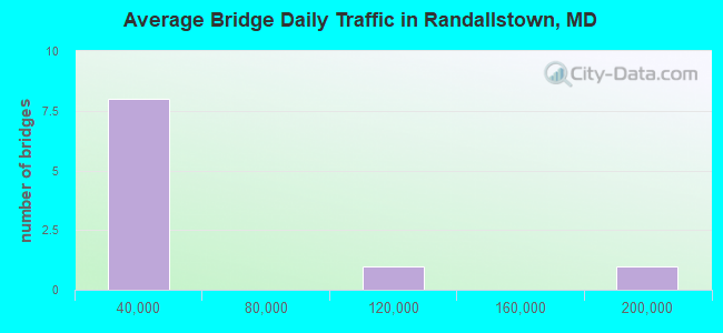
- 371,559Total average daily traffic
- 4,970Total average daily truck traffic
- National Bridge Inventory (NBI) Registered Bridges for Randallstown
- No street view available for this location
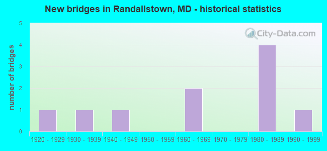
- New bridges - historical statistics
- 11920-1929
- 11930-1939
- 11940-1949
- 21960-1969
- 41980-1989
- 11990-1999
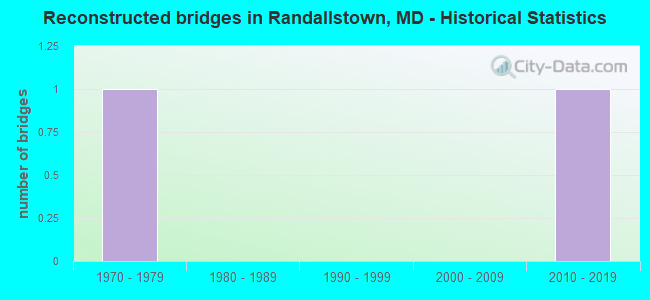
- Reconstructed bridges - Historical Statistics
- 11970-1979
- 01980-1989
- 01990-1999
- 02000-2009
- 12010-2019
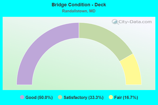
- Bridge Condition - Deck
- 50.0%Good
- 33.3%Satisfactory
- 16.7%Fair
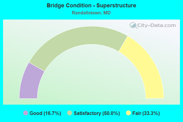
- Bridge Condition - Superstructure
- 16.7%Good
- 50.0%Satisfactory
- 33.3%Fair
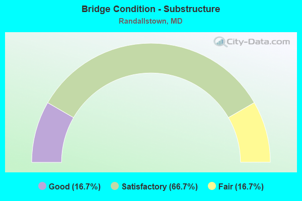
- Bridge Condition - Substructure
- 16.7%Good
- 66.7%Satisfactory
- 16.7%Fair
Find on map >> Show street view
Structure Number: 10000003031601, Location: 0.06 MI W OF PURDY LA (Lat: 39.390881, Lng: -76.762181), Route carried "on" structure: County highway 2250, Year Built: 1983, Status: Open, Structure Length: 9.33m (30.61ft), Average Daily Traffic: 13,860 (year 2016), Truck Traffic: 8%, Average Future Daily Traffic: 83,840 (year 2036), Design Load: HS 20, Features Intersected: IS 795, MTA METRO, Facility Carried by Structure: MCDONOGH ROAD
Minimum Vertical Clearance: 30+ m (98+ ft), Kilometerpoint: 1.432, Lanes on structure: 2, Lanes under structure: 6, Owner: State Highway Agency, Approaching Roadway Width: 7.3m (24.0ft), Skew: 1 degrees, Material/Design: Steel continuous, Design/Construction: Stringer/Multi-beam, Number Of Spans In Main Unit: 2, Length of Maximum Span: 49.4m (162.1ft), Curb or Sidewalk Widths: Left: 0.0m, Right: 1.6m (5.2ft), Curb-To-Curb Width: 12.2m (40.0ft), Out-to-Out Width: 14.8m (48.6ft)
Condition: Deck: Good, Superstructure: Satisfactory, Substructure: Satisfactory, Inventory Rating: 55.8 metric tons, Method Used To Determine Inventory Rating: Load Factor (LF), Structural Evaluation: Equal to present minimum criteria, Deck Geometry: Somewhat better than minimum adequacy, Underclear: Somewhat better than minimum adequacy, Approach Roadway Alignment: Equal to present desirable criteria, Designated Inspection Frequency: Every 24 months, Inspection Date: May 2021, Deck Structure Type: Concrete Cast-file-Place, Wearing Surface/Protective System: Wearing Surface: Monolithic Concrete, Deck Protection: Epoxy Coated Reinforcing
Find on map >> Show street view
Structure Number: 200000B-017001, Location: 0.92 MI S OF MD 125 (Lat: 39.332689, Lng: -76.821389), Route carried "on" structure: County highway 2356, Year Built: 1930, Year Reconstructed: 1981, Status: Open, Structure Length: 1.12m (3.67ft), Average Daily Traffic: 1,300 (year 2013), Truck Traffic: 5%, Average Future Daily Traffic: 3,400 (year 2040), Design Load: HS 20, Features Intersected: BRICE RUN, Facility Carried by Structure: DOGWOOD ROAD
Minimum Vertical Clearance: 30+ m (98+ ft), Kilometerpoint: 1.480, Lanes on structure: 2, Owner: County Highway Agency, Approaching Roadway Width: 6.1m (20.0ft), Material/Design: Concrete, Design/Construction: Slab, Number Of Spans In Main Unit: 2, Length of Maximum Span: 5.8m (19.0ft), Curb or Sidewalk Widths: Left: 0.3m (1.0ft), Right: 0.3m (1.0ft), Curb-To-Curb Width: 7.3m (24.0ft), Out-to-Out Width: 7.9m (25.9ft)
Condition: Deck: Satisfactory, Superstructure: Satisfactory, Substructure: Satisfactory, Channel: Satisfactory, Operating Rating: 50.8 metric tons, Method Used To Determine Operating Rating: Load Factor (LF), Inventory Rating: 30.4 metric tons, Method Used To Determine Inventory Rating: Load Factor (LF), Structural Evaluation: Equal to present minimum criteria, Deck Geometry: Meets minimum limits, Waterway Adequacy: Better than present minimum criteria, Approach Roadway Alignment: Equal to present desirable criteria, Designated Inspection Frequency: Every 24 months, Inspection Date: May 2021, Deck Structure Type: Concrete Cast-file-Place, Wearing Surface/Protective System: Wearing Surface: Monolithic Concrete
Find on map >> Show street view
Structure Number: 200000B-018301, Location: 0.92 MI S OF MD 26 (Lat: 39.363392, Lng: -76.810633), Route carried "on" structure: County highway 2300, Year Built: 1920, Status: Posted for load, Structure Length: 0.79m (2.59ft), Average Daily Traffic: 3,037 (year 2021), Truck Traffic: 5%, Average Future Daily Traffic: 4,074 (year 2041), Features Intersected: BRICE RUN BRANCH, Facility Carried by Structure: OFFUTT ROAD
Minimum Vertical Clearance: 30+ m (98+ ft), Kilometerpoint: 1.480, Lanes on structure: 1, Owner: County Highway Agency, Approaching Roadway Width: 5.5m (18.0ft), Skew: 3 degrees, Material/Design: Concrete, Design/Construction: Tee Beam, Number Of Spans In Main Unit: 1, Length of Maximum Span: 6.4m (21.0ft), Curb-To-Curb Width: 5.3m (17.4ft), Out-to-Out Width: 6.1m (20.0ft)
Condition: Deck: Satisfactory, Superstructure: Fair, Substructure: Satisfactory, Channel: Satisfactory, Operating Rating: 34.0 metric tons, Method Used To Determine Operating Rating: Load Factor (LF), Inventory Rating: 20.4 metric tons, Method Used To Determine Inventory Rating: Load Factor (LF), Structural Evaluation: Somewhat better than minimum adequacy, Deck Geometry: High priority of replacement, Waterway Adequacy: Equal to present desirable criteria, Approach Roadway Alignment: Equal to present minimum criteria, Bridge Posting: Required (Relationship of Operating Rating to Maximum Legal Load: 0.1 - 9.9% below), Length Of Structure Improvement: 1.40m (4.59ft), Designated Inspection Frequency: Every 24 months, Other Special Inspection Frequency: Every 12 months, Inspection Date: June 2021, Other Special Inspection Date: June 2021, Bridge Improvement Cost: $3,000, Roadway Improvement Cost: $6,000, Total Project Cost: $9,000, Deck Structure Type: Concrete Cast-file-Place, Wearing Surface/Protective System: Wearing Surface: Bituminous
Find on map >> Show street view
Structure Number: 200000B-021101, Location: 0.5 MI N OF MD RTE 26 (Lat: 39.373800, Lng: -76.791200), Route carried "on" structure: Bypass County highway 2250, Year Built: 1993, Status: Open, Structure Length: 3.14m (10.30ft), Average Daily Traffic: 4,300 (year 2013), Truck Traffic: 5%, Average Future Daily Traffic: 8,000 (year 2035), Design Load: HS 20, Features Intersected: SCOTTS LEVEL BRANCH, Facility Carried by Structure: MCDONOGH ROAD
Minimum Vertical Clearance: 30+ m (98+ ft), Kilometerpoint: 5.455, Lanes on structure: 2, Owner: County Highway Agency, Approaching Roadway Width: 11.0m (36.1ft), Material/Design: Prestressed concrete, Design/Construction: Stringer/Multi-beam, Number Of Spans In Main Unit: 3, Length of Maximum Span: 10.4m (34.1ft), Curb or Sidewalk Widths: Left: 1.8m (5.9ft), Right: 1.8m (5.9ft), Curb-To-Curb Width: 11.0m (36.1ft), Out-to-Out Width: 15.9m (52.2ft)
Condition: Deck: Good, Superstructure: Good, Substructure: Good, Channel: Satisfactory, Operating Rating: 81.2 metric tons, Method Used To Determine Operating Rating: Load Factor (LF), Inventory Rating: 48.5 metric tons, Method Used To Determine Inventory Rating: Load Factor (LF), Structural Evaluation: Better than present minimum criteria, Deck Geometry: Somewhat better than minimum adequacy, Waterway Adequacy: Equal to present desirable criteria, Approach Roadway Alignment: Equal to present desirable criteria, Designated Inspection Frequency: Every 24 months, Inspection Date: October 2021, Wearing Surface/Protective System: Wearing Surface: Bituminous, Membrane: Other, Deck Protection: Epoxy Coated Reinforcing
Find on map >> Show street view
Structure Number: 200000B-023801, Location: 0.67 MI N OF MD 26 (Lat: 39.372194, Lng: -76.787314), Route carried "on" structure: County highway 2229, Year Built: 1982, Status: Open, Structure Length: 2.99m (9.81ft), Average Daily Traffic: 12,747 (year 2021), Truck Traffic: 5%, Average Future Daily Traffic: 17,613 (year 2041), Design Load: HS 20, Features Intersected: SCOTTS LEVEL BRANCH, Facility Carried by Structure: BRENBROOK DRIVE
Minimum Vertical Clearance: 30+ m (98+ ft), Kilometerpoint: 0.644, Lanes on structure: 3, Owner: County Highway Agency, Approaching Roadway Width: 12.8m (42.0ft), Skew: 3 degrees, Material/Design: Prestressed concrete, Design/Construction: Box Beam or Girders - Multiple, Number Of Spans In Main Unit: 3, Length of Maximum Span: 10.1m (33.1ft), Curb or Sidewalk Widths: Left: 1.9m (6.2ft), Right: 1.9m (6.2ft), Curb-To-Curb Width: 12.6m (41.3ft), Out-to-Out Width: 17.7m (58.1ft)
Condition: Deck: Fair, Superstructure: Fair, Substructure: Fair, Channel: Satisfactory, Inventory Rating: 67.1 metric tons, Method Used To Determine Inventory Rating: Load Factor (LF), Structural Evaluation: Somewhat better than minimum adequacy, Deck Geometry: Meets minimum limits, Waterway Adequacy: Better than present minimum criteria, Approach Roadway Alignment: Equal to present desirable criteria, Designated Inspection Frequency: Every 24 months, Inspection Date: June 2021, Wearing Surface/Protective System: Wearing Surface: Bituminous
Find on map >> Show street view
Structure Number: 200000B-035702, Location: 0.4 MI S OF WINANDS RD (Lat: 39.380033, Lng: -76.807219), Route carried "on" structure: County highway 2291, Year Built: 1969, Status: Posted for load, Structure Length: 1.07m (3.51ft), Average Daily Traffic: 10,358 (year 2019), Truck Traffic: 10%, Average Future Daily Traffic: 18,527 (year 2039), Design Load: HS 20, Features Intersected: SCOTTS LEVEL BRANCH, Facility Carried by Structure: TULSMERE ROAD
Minimum Vertical Clearance: 30+ m (98+ ft), Kilometerpoint: 0.257, Lanes on structure: 2, Owner: County Highway Agency, Approaching Roadway Width: 12.2m (40.0ft), Material/Design: Concrete, Design/Construction: Culvert, Length of Maximum Span: 4.9m (16.1ft), Curb or Sidewalk Widths: Left: 1.2m (3.9ft), Right: 1.2m (3.9ft)
Condition: Channel: Satisfactory, Culverts: Satisfactory, Operating Rating: 29.5 metric tons, Method Used To Determine Operating Rating: Load Factor (LF), Inventory Rating: 17.7 metric tons, Method Used To Determine Inventory Rating: Load Factor (LF), Structural Evaluation: Meets minimum limits, Waterway Adequacy: Somewhat better than minimum adequacy, Approach Roadway Alignment: Better than present minimum criteria, Bridge Posting: Required (Relationship of Operating Rating to Maximum Legal Load: 30.0 - 39.9% below), Designated Inspection Frequency: Every 24 months, Other Special Inspection Frequency: Every 12 months, Inspection Date: July 2021, Other Special Inspection Date: July 2021
Find on map >> Show street view
Structure Number: 200000B-035902, Location: 0.09 MI N OF ZETA WAY (Lat: 39.379500, Lng: -76.796897), Route carried "on" structure: County highway 2301, Year Built: 1968, Status: Posted for load, Structure Length: 0.88m (2.89ft), Average Daily Traffic: 9,455 (year 2021), Truck Traffic: 10%, Average Future Daily Traffic: 15,493 (year 2041), Design Load: HS 20, Features Intersected: SCOTTS LEVEL BRANCH, Facility Carried by Structure: OFFUTT ROAD
Minimum Vertical Clearance: 30+ m (98+ ft), Kilometerpoint: 0.418, Lanes on structure: 2, Owner: County Highway Agency, Approaching Roadway Width: 12.8m (42.0ft), Material/Design: Concrete, Design/Construction: Culvert, Length of Maximum Span: 4.3m (14.1ft)
Condition: Channel: Satisfactory, Culverts: Satisfactory, Operating Rating: 51.2 metric tons, Method Used To Determine Operating Rating: Load Factor (LF), Inventory Rating: 30.8 metric tons, Method Used To Determine Inventory Rating: Load Factor (LF), Structural Evaluation: Equal to present minimum criteria, Waterway Adequacy: Equal to present desirable criteria, Approach Roadway Alignment: Equal to present desirable criteria, Designated Inspection Frequency: Every 24 months, Inspection Date: May 2021
Find on map >> Show street view
Structure Number: 200000B-059601, Location: 0.15 MI W OF IS 795 (Lat: 39.391289, Lng: -76.765094), Route carried "on" structure: County highway , Year Built: 1941, Year Reconstructed: 2010, Status: Open, Structure Length: 4.11m (13.48ft), Average Daily Traffic: 16,283 (year 2021), Truck Traffic: 5%, Average Future Daily Traffic: 21,931 (year 2041), Design Load: H 20, Features Intersected: GWYNNS FALLS, Facility Carried by Structure: McDONOGH ROAD
Minimum Vertical Clearance: 30+ m (98+ ft), Kilometerpoint: 0.209, Lanes on structure: 2, Owner: County Highway Agency, Approaching Roadway Width: 14.0m (45.9ft), Material/Design: Steel continuous, Design/Construction: Stringer/Multi-beam, Number Of Spans In Main Unit: 3, Length of Maximum Span: 15.2m (49.9ft), Curb-To-Curb Width: 9.8m (32.2ft), Out-to-Out Width: 10.7m (35.1ft)
Condition: Deck: Good, Superstructure: Satisfactory, Substructure: Satisfactory, Channel: Satisfactory, Operating Rating: 54.9 metric tons, Method Used To Determine Operating Rating: Load Factor (LF), Inventory Rating: 32.7 metric tons, Method Used To Determine Inventory Rating: Load Factor (LF), Structural Evaluation: Equal to present minimum criteria, Deck Geometry: Meets minimum limits, Waterway Adequacy: Better than present minimum criteria, Approach Roadway Alignment: Equal to present desirable criteria, Length Of Structure Improvement: 4.11m (13.48ft), Designated Inspection Frequency: Every 24 months, Underwater Inspection Frequency: Every 48 months, Inspection Date: November 2021, Underwater Inspection Date: November 2019, Bridge Improvement Cost: $282,000, Roadway Improvement Cost: $28,000, Total Project Cost: $310,000, Deck Structure Type: Concrete Cast-file-Place, Wearing Surface/Protective System: Wearing Surface: Monolithic Concrete
Find on map >> Show street view
Structure Number: 10000003030801, Location: @ IS 795 & IS 695 (Lat: 39.372972, Lng: -76.748236), Route carried "under" structure: Interstate 695, Year Built: 1983, Structure Length: 0. m, Average Daily Traffic: 189,237 (year 2009), Features Intersected: IS 695, MTA METRO, Facility Carried by Structure: IS 795 RAMP B
Minimum Vertical Clearance: 5.18m (16.99ft), Kilometerpoint: 19.131, Lanes on structure: 2, Lanes under structure: 8, Material/Design: Steel continuous, Design/Construction: Stringer/Multi-beam, Length of Maximum Span: 51.8m (169.9ft)
Find on map >> Show street view
Structure Number: 10000003031601, Location: .62 M N OF MT WILSON LANE (Lat: 39.390881, Lng: -76.762181), Route carried "under" structure: Interstate 795, Year Built: 1983, Structure Length: 0. m, Average Daily Traffic: 110,982 (year 2009), Features Intersected: IS 795, MTA METRO, Facility Carried by Structure: MCDONOGH ROAD
Minimum Vertical Clearance: 4.88m (16.01ft), Kilometerpoint: 2.494, Lanes on structure: 2, Lanes under structure: 6, Material/Design: Steel continuous, Design/Construction: Stringer/Multi-beam, Length of Maximum Span: 49.4m (162.1ft)