Bridge Statistics for Ramtown, New Jersey (NJ)
Condition, Traffic, Stress, Structural Evaluation, Project Costs
- National Bridge Inventory (NBI) Statistics
- 17Number of bridges
- 115ft / 35.4mTotal length
- 510,091Total average daily traffic
- 17,213Total average daily truck traffic
- National Bridge Inventory (NBI) Registered Bridges for Ramtown
- No street view available for this location
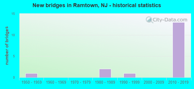
- New bridges - historical statistics
- 11950-1959
- 21980-1989
- 11990-1999
- 132010-2019
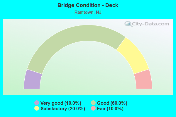
- Bridge Condition - Deck
- 10.0%Very good
- 60.0%Good
- 20.0%Satisfactory
- 10.0%Fair
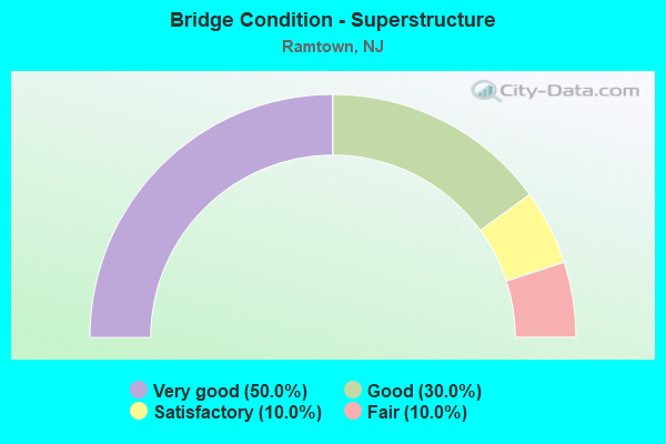
- Bridge Condition - Superstructure
- 50.0%Very good
- 30.0%Good
- 10.0%Satisfactory
- 10.0%Fair
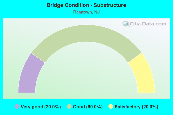
- Bridge Condition - Substructure
- 20.0%Very good
- 60.0%Good
- 20.0%Satisfactory
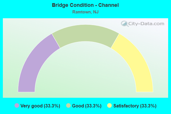
- Bridge Condition - Channel
- 33.3%Very good
- 33.3%Good
- 33.3%Satisfactory
Find on map >> Show street view
Structure Number: 130HL59, Location: 1 MI NORTH OF CO RD#526 (Lat: 40.109581, Lng: -74.161589), Route carried "on" structure: Other road , Year Built: 1952, Year Reconstructed: 1991, Status: Open, Structure Length: 0.98m (3.22ft), Average Daily Traffic: 793 (year 2021), Truck Traffic: 3%, Average Future Daily Traffic: 963 (year 2041), Design Load: HS 20+Mod, Features Intersected: MUDDY FORD BROOK, Facility Carried by Structure: RAMTOWN-GREENVL RD
Minimum Vertical Clearance: 30+ m (98+ ft), Kilometerpoint: 0.000, Lanes on structure: 2, Owner: County Highway Agency, Approaching Roadway Width: 7.9m (25.9ft), Material/Design: Concrete continuous, Design/Construction: Slab, Number Of Spans In Main Unit: 2, Length of Maximum Span: 4.6m (15.1ft), Curb-To-Curb Width: 7.9m (25.9ft), Out-to-Out Width: 8.5m (27.9ft)
Condition: Deck: Satisfactory, Superstructure: Satisfactory, Substructure: Satisfactory, Channel: Satisfactory, Operating Rating: 66.2 metric tons, Method Used To Determine Operating Rating: Load Factor (LF), Inventory Rating: 39.9 metric tons, Method Used To Determine Inventory Rating: Load Factor (LF), Structural Evaluation: Equal to present minimum criteria, Deck Geometry: Somewhat better than minimum adequacy, Waterway Adequacy: Better than present minimum criteria, Approach Roadway Alignment: Equal to present minimum criteria, Designated Inspection Frequency: Every 24 months, Underwater Inspection Frequency: Every 48 months, Inspection Date: April 2021, Underwater Inspection Date: June 2021, Deck Structure Type: Concrete Cast-file-Place, Wearing Surface/Protective System: Wearing Surface: Monolithic Concrete
Find on map >> Show street view
Structure Number: 1506003, Location: 0.25 MI. SOUTH OF NJ 88 (Lat: 40.078761, Lng: -74.156311), Route carried "on" structure: County highway 549, Year Built: 1996, Status: Open, Structure Length: 1.04m (3.41ft), Average Daily Traffic: 22,680 (year 2020), Truck Traffic: 4%, Average Future Daily Traffic: 27,670 (year 2040), Design Load: HS 25 or greater, Features Intersected: SO BRCH METEDECONK RIVER
Minimum Vertical Clearance: 30+ m (98+ ft), Kilometerpoint: 16.866, Lanes on structure: 6, Base Highway Network: Yes, Owner: County Highway Agency, Approaching Roadway Width: 26.8m (87.9ft), Material/Design: Prestressed concrete, Design/Construction: Slab, Number Of Spans In Main Unit: 1, Length of Maximum Span: 9.4m (30.8ft), Curb or Sidewalk Widths: Left: 3.4m (11.2ft), Right: 0.0m, Curb-To-Curb Width: 26.9m (88.3ft), Out-to-Out Width: 32.7m (107.3ft)
Condition: Deck: Satisfactory, Superstructure: Good, Substructure: Satisfactory, Channel: Good, Inventory Rating: 66.2 metric tons, Method Used To Determine Inventory Rating: Load Factor (LF), Structural Evaluation: Equal to present minimum criteria, Deck Geometry: Better than present minimum criteria, Waterway Adequacy: Equal to present desirable criteria, Approach Roadway Alignment: Equal to present desirable criteria, Designated Inspection Frequency: Every 24 months, Underwater Inspection Frequency: Every 48 months, Inspection Date: May 2020, Underwater Inspection Date: June 2020, Deck Structure Type: Concrete Cast-file-Place, Wearing Surface/Protective System: Wearing Surface: Monolithic Concrete, Deck Protection: Epoxy Coated Reinforcing
Find on map >> Show street view
Structure Number: 1506004, Location: 0.7 MI N OF NJ 88 (Lat: 40.091569, Lng: -74.152169), Route carried "on" structure: County highway 549, Year Built: 1985, Status: Open, Structure Length: 1.46m (4.79ft), Average Daily Traffic: 21,085 (year 2020), Truck Traffic: 4%, Average Future Daily Traffic: 25,725 (year 2040), Design Load: HS 20, Features Intersected: NO BRCH METEDECONK RIVER
Minimum Vertical Clearance: 30+ m (98+ ft), Kilometerpoint: 18.459, Lanes on structure: 4, Base Highway Network: Yes, Owner: County Highway Agency, Approaching Roadway Width: 15.2m (49.9ft), Material/Design: Prestressed concrete, Design/Construction: Slab, Number Of Spans In Main Unit: 1, Length of Maximum Span: 13.7m (44.9ft), Curb or Sidewalk Widths: Left: 1.2m (3.9ft), Right: 0.3m (1.0ft), Curb-To-Curb Width: 15.2m (49.9ft), Out-to-Out Width: 18.3m (60.0ft)
Condition: Deck: Fair, Superstructure: Fair, Substructure: Good, Channel: Satisfactory, Operating Rating: 59.0 metric tons, Method Used To Determine Operating Rating: Load Factor (LF), Inventory Rating: 35.4 metric tons, Method Used To Determine Inventory Rating: Load Factor (LF), Structural Evaluation: Somewhat better than minimum adequacy, Deck Geometry: High priority of corrective action, Waterway Adequacy: Equal to present desirable criteria, Approach Roadway Alignment: Equal to present minimum criteria, Designated Inspection Frequency: Every 24 months, Underwater Inspection Frequency: Every 48 months, Inspection Date: May 2020, Underwater Inspection Date: May 2020, Deck Structure Type: Concrete Precast Panels, Wearing Surface/Protective System: Wearing Surface: Bituminous
Find on map >> Show street view
Structure Number: 151415, Location: 0.14 MI EAST OF GSP JCT (Lat: 40.081489, Lng: -74.151861), Route carried "on" structure: State highway 88, Year Built: 1987, Status: Open, Structure Length: 1.68m (5.51ft), Average Daily Traffic: 12,545 (year 2020), Truck Traffic: 4%, Average Future Daily Traffic: 15,054 (year 2040), Design Load: HS 20+Mod, Features Intersected: N. Br. Metedeconk River
Minimum Vertical Clearance: 30+ m (98+ ft), Kilometerpoint: 5.713, Lanes on structure: 2, Base Highway Network: Yes, Owner: State Highway Agency, Approaching Roadway Width: 15.2m (49.9ft), Material/Design: Prestressed concrete, Design/Construction: Box Beam or Girders - Multiple, Number Of Spans In Main Unit: 1, Length of Maximum Span: 15.8m (51.8ft), Curb or Sidewalk Widths: Left: 1.9m (6.2ft), Right: 1.8m (5.9ft), Curb-To-Curb Width: 15.3m (50.2ft), Out-to-Out Width: 19.7m (64.6ft)
Condition: Deck: Good, Superstructure: Very good, Substructure: Good, Channel: Satisfactory, Inventory Rating: 87.1 metric tons, Method Used To Determine Inventory Rating: Load Factor (LF), Structural Evaluation: Better than present minimum criteria, Deck Geometry: Superior to present desirable criteria, Waterway Adequacy: Superior to present desirable criteria, Approach Roadway Alignment: Better than present minimum criteria, Designated Inspection Frequency: Every 24 months, Underwater Inspection Frequency: Every 48 months, Inspection Date: September 2020, Underwater Inspection Date: August 2018, Deck Structure Type: Concrete Cast-file-Place, Wearing Surface/Protective System: Deck Protection: Epoxy Coated Reinforcing
Find on map >> Show street view
Structure Number: 360911N, Location: 0.25 MI S OF RT88&GSP JCT (Lat: 40.077808, Lng: -74.155647), Route carried "on" structure: Other road GSP, Year Built: 2015, Status: Open, Structure Length: 4.21m (13.81ft), Average Daily Traffic: 54,780 (year 2021), Truck Traffic: 3%, Average Future Daily Traffic: 66,830 (year 2041), Design Load: HL 93, Features Intersected: CHAMBERS BR RD (CR549)
Minimum Vertical Clearance: 30+ m (98+ ft), Kilometerpoint: 146.595, Lanes on structure: 3, Lanes under structure: 4, Base Highway Network: Yes, Toll: On toll road, Owner: State Toll Authority, Approaching Roadway Width: 19.2m (63.0ft), Skew: 4 degrees, Material/Design: Steel, Design/Construction: Stringer/Multi-beam, Number Of Spans In Main Unit: 1, Length of Maximum Span: 39.6m (129.9ft), Curb-To-Curb Width: 19.4m (63.6ft), Out-to-Out Width: 20.5m (67.3ft)
Condition: Deck: Good, Superstructure: Very good, Substructure: Very good, Operating Rating: 59.9 metric tons, Method Used To Determine Operating Rating: Load and Resistance Factor Rating (LRFR) rating reported by rating factor(RF) method using HL-93 loadings, Inventory Rating: 46.3 metric tons, Method Used To Determine Inventory Rating: Load and Resistance Factor Rating (LRFR) rating reported by rating factor(RF) method using HL-93 loadings, Structural Evaluation: Equal to present desirable criteria, Deck Geometry: Superior to present desirable criteria, Underclear: Equal to present minimum criteria, Approach Roadway Alignment: Equal to present desirable criteria, Designated Inspection Frequency: Every 24 months, Inspection Date: April 2021, Deck Structure Type: Concrete Cast-file-Place, Wearing Surface/Protective System: Wearing Surface: Monolithic Concrete, Deck Protection: Epoxy Coated Reinforcing
Find on map >> Show street view
Structure Number: 360911S, Location: 0.25 MI S OF RT88&GSP JCT (Lat: 40.078150, Lng: -74.156033), Route carried "on" structure: Other road GSP, Year Built: 2015, Status: Open, Structure Length: 4.33m (14.21ft), Average Daily Traffic: 54,780 (year 2021), Truck Traffic: 3%, Average Future Daily Traffic: 66,830 (year 2041), Design Load: HL 93, Features Intersected: CHAMBERS BR RD (CR 549)
Minimum Vertical Clearance: 30+ m (98+ ft), Kilometerpoint: 146.595, Lanes on structure: 3, Lanes under structure: 4, Base Highway Network: Yes, Toll: On toll road, Owner: State Toll Authority, Approaching Roadway Width: 18.6m (61.0ft), Skew: 4 degrees, Material/Design: Steel, Design/Construction: Stringer/Multi-beam, Number Of Spans In Main Unit: 1, Length of Maximum Span: 40.8m (133.9ft), Curb-To-Curb Width: 18.7m (61.4ft), Out-to-Out Width: 19.8m (65.0ft)
Condition: Deck: Very good, Superstructure: Very good, Substructure: Very good, Operating Rating: 60.6 metric tons, Method Used To Determine Operating Rating: Load and Resistance Factor Rating (LRFR) rating reported by rating factor(RF) method using HL-93 loadings, Inventory Rating: 47.0 metric tons, Method Used To Determine Inventory Rating: Load and Resistance Factor Rating (LRFR) rating reported by rating factor(RF) method using HL-93 loadings, Structural Evaluation: Equal to present desirable criteria, Deck Geometry: Superior to present desirable criteria, Underclear: Equal to present minimum criteria, Approach Roadway Alignment: Equal to present desirable criteria, Designated Inspection Frequency: Every 24 months, Inspection Date: April 2021, Deck Structure Type: Concrete Cast-file-Place, Wearing Surface/Protective System: Wearing Surface: Monolithic Concrete, Deck Protection: Epoxy Coated Reinforcing
Find on map >> Show street view
Structure Number: 360912N, Location: 0.2 MI.S.OF RT88& GSP JCT (Lat: 40.079228, Lng: -74.155289), Route carried "on" structure: Other road GSP, Year Built: 2015, Status: Open, Structure Length: 3.75m (12.30ft), Average Daily Traffic: 57,330 (year 2021), Truck Traffic: 3%, Average Future Daily Traffic: 69,950 (year 2041), Design Load: HL 93, Features Intersected: S. BR.METEDECONK RIVER
Minimum Vertical Clearance: 30+ m (98+ ft), Kilometerpoint: 146.772, Lanes on structure: 3, Base Highway Network: Yes, Toll: On toll road, Owner: State Toll Authority, Approaching Roadway Width: 18.6m (61.0ft), Skew: 3 degrees, Material/Design: Steel, Design/Construction: Stringer/Multi-beam, Number Of Spans In Main Unit: 1, Length of Maximum Span: 36.6m (120.1ft), Curb-To-Curb Width: 18.5m (60.7ft), Out-to-Out Width: 19.7m (64.6ft)
Condition: Deck: Good, Superstructure: Very good, Substructure: Good, Channel: Very good, Operating Rating: 62.5 metric tons, Method Used To Determine Operating Rating: Load and Resistance Factor Rating (LRFR) rating reported by rating factor(RF) method using HL-93 loadings, Inventory Rating: 48.3 metric tons, Method Used To Determine Inventory Rating: Load and Resistance Factor Rating (LRFR) rating reported by rating factor(RF) method using HL-93 loadings, Structural Evaluation: Better than present minimum criteria, Deck Geometry: Superior to present desirable criteria, Waterway Adequacy: Equal to present desirable criteria, Approach Roadway Alignment: Equal to present desirable criteria, Designated Inspection Frequency: Every 24 months, Inspection Date: April 2021, Deck Structure Type: Concrete Cast-file-Place, Wearing Surface/Protective System: Wearing Surface: Monolithic Concrete, Deck Protection: Epoxy Coated Reinforcing
Find on map >> Show street view
Structure Number: 360912S, Location: 0.2 MI.S.OF RT88& GSP JCT (Lat: 40.079311, Lng: -74.155578), Route carried "on" structure: Other road GSP, Year Built: 2015, Status: Open, Structure Length: 3.26m (10.70ft), Average Daily Traffic: 53,115 (year 2021), Truck Traffic: 3%, Average Future Daily Traffic: 64,800 (year 2041), Design Load: HL 93, Features Intersected: S.Br. Metedeconk River
Minimum Vertical Clearance: 30+ m (98+ ft), Kilometerpoint: 146.772, Lanes on structure: 3, Base Highway Network: Yes, Toll: On toll road, Owner: State Toll Authority, Approaching Roadway Width: 18.6m (61.0ft), Skew: 3 degrees, Material/Design: Steel, Design/Construction: Stringer/Multi-beam, Number Of Spans In Main Unit: 1, Length of Maximum Span: 31.7m (104.0ft), Curb-To-Curb Width: 18.5m (60.7ft), Out-to-Out Width: 19.7m (64.6ft)
Condition: Deck: Good, Superstructure: Very good, Substructure: Good, Channel: Very good, Operating Rating: 61.2 metric tons, Method Used To Determine Operating Rating: Load and Resistance Factor Rating (LRFR) rating reported by rating factor(RF) method using HL-93 loadings, Inventory Rating: 47.0 metric tons, Method Used To Determine Inventory Rating: Load and Resistance Factor Rating (LRFR) rating reported by rating factor(RF) method using HL-93 loadings, Structural Evaluation: Better than present minimum criteria, Deck Geometry: Superior to present desirable criteria, Waterway Adequacy: Equal to present desirable criteria, Approach Roadway Alignment: Equal to present desirable criteria, Designated Inspection Frequency: Every 24 months, Inspection Date: April 2021, Deck Structure Type: Concrete Cast-file-Place, Wearing Surface/Protective System: Wearing Surface: Monolithic Concrete, Deck Protection: Epoxy Coated Reinforcing
Find on map >> Show street view
Structure Number: 360915S, Location: 1.5 MI NW OF RT70&88 CIR (Lat: 40.083825, Lng: -74.153314), Route carried "on" structure: Other road GSP, Year Built: 2015, Status: Open, Structure Length: 4.79m (15.72ft), Average Daily Traffic: 52,025 (year 2021), Truck Traffic: 3%, Average Future Daily Traffic: 63,470 (year 2041), Design Load: HL 93, Features Intersected: N.Br. Metedeconk River
Minimum Vertical Clearance: 30+ m (98+ ft), Kilometerpoint: 147.271, Lanes on structure: 3, Base Highway Network: Yes, Toll: On toll road, Owner: State Toll Authority, Approaching Roadway Width: 18.6m (61.0ft), Skew: 2 degrees, Material/Design: Steel, Design/Construction: Stringer/Multi-beam, Number Of Spans In Main Unit: 1, Length of Maximum Span: 39.6m (129.9ft), Curb-To-Curb Width: 18.5m (60.7ft), Out-to-Out Width: 19.7m (64.6ft)
Condition: Deck: Good, Superstructure: Good, Substructure: Good, Channel: Very good, Operating Rating: 58.6 metric tons, Method Used To Determine Operating Rating: Load and Resistance Factor Rating (LRFR) rating reported by rating factor(RF) method using HL-93 loadings, Inventory Rating: 45.0 metric tons, Method Used To Determine Inventory Rating: Load and Resistance Factor Rating (LRFR) rating reported by rating factor(RF) method using HL-93 loadings, Structural Evaluation: Better than present minimum criteria, Deck Geometry: Superior to present desirable criteria, Waterway Adequacy: Equal to present desirable criteria, Approach Roadway Alignment: Better than present minimum criteria, Designated Inspection Frequency: Every 24 months, Inspection Date: April 2021, Deck Structure Type: Concrete Cast-file-Place, Wearing Surface/Protective System: Wearing Surface: Monolithic Concrete, Deck Protection: Epoxy Coated Reinforcing
Find on map >> Show street view
Structure Number: 360926C, Location: 0.02MI S OF CR 549 (Lat: 40.094981, Lng: -74.144331), Route carried "on" structure: Ramp Other road GSP, Year Built: 2017, Status: Open, Structure Length: 0.79m (2.59ft), Average Daily Traffic: 99 (year 2021), Truck Traffic: 3%, Average Future Daily Traffic: 121 (year 2041), Design Load: HL 93, Features Intersected: N. BRANCH METEDECONK RIV
Minimum Vertical Clearance: 30+ m (98+ ft), Kilometerpoint: 149.025, Lanes on structure: 1, Toll: On toll road, Owner: State Toll Authority, Approaching Roadway Width: 6.7m (22.0ft), Skew: 5 degrees, Material/Design: Concrete, Design/Construction: Culvert, Number Of Spans In Main Unit: 1, Length of Maximum Span: 7.9m (25.9ft), Curb or Sidewalk Widths: Left: 1.2m (3.9ft), Right: 1.2m (3.9ft)
Condition: Channel: Good, Culverts: Very good, Operating Rating: 67.4 metric tons, Method Used To Determine Operating Rating: Load and Resistance Factor Rating (LRFR) rating reported by rating factor(RF) method using HL-93 loadings, Inventory Rating: 51.8 metric tons, Method Used To Determine Inventory Rating: Load and Resistance Factor Rating (LRFR) rating reported by rating factor(RF) method using HL-93 loadings, Structural Evaluation: Equal to present desirable criteria, Waterway Adequacy: Equal to present desirable criteria, Approach Roadway Alignment: Equal to present desirable criteria, Designated Inspection Frequency: Every 24 months, Inspection Date: June 2021
Find on map >> Show street view
Structure Number: 360926D, Location: 0.02MI S OF CR 549 (Lat: 40.095831, Lng: -74.142850), Route carried "on" structure: Ramp Other road GSP, Year Built: 2017, Status: Open, Structure Length: 0.73m (2.40ft), Average Daily Traffic: 750 (year 2021), Truck Traffic: 3%, Average Future Daily Traffic: 915 (year 2041), Design Load: HL 93, Features Intersected: N. BRANCH METEDECONK RIV
Minimum Vertical Clearance: 30+ m (98+ ft), Kilometerpoint: 149.025, Lanes on structure: 2, Toll: On toll road, Owner: State Toll Authority, Approaching Roadway Width: 9.8m (32.2ft), Skew: 4 degrees, Material/Design: Concrete, Design/Construction: Culvert, Number Of Spans In Main Unit: 1, Length of Maximum Span: 7.3m (24.0ft), Curb or Sidewalk Widths: Left: 1.2m (3.9ft), Right: 1.2m (3.9ft)
Condition: Channel: Good, Culverts: Very good, Operating Rating: 83.3 metric tons, Method Used To Determine Operating Rating: Load and Resistance Factor Rating (LRFR) rating reported by rating factor(RF) method using HL-93 loadings, Inventory Rating: 64.5 metric tons, Method Used To Determine Inventory Rating: Load and Resistance Factor Rating (LRFR) rating reported by rating factor(RF) method using HL-93 loadings, Structural Evaluation: Equal to present desirable criteria, Waterway Adequacy: Equal to present desirable criteria, Approach Roadway Alignment: Equal to present desirable criteria, Designated Inspection Frequency: Every 24 months, Inspection Date: June 2021
Find on map >> Show street view
Structure Number: 360926T, Location: 2.0MI N OF RTS 70&88 CIR (Lat: 40.097400, Lng: -74.142950), Route carried "on" structure: County highway 549, Year Built: 2014, Status: Open, Structure Length: 8.35m (27.40ft), Average Daily Traffic: 26,918 (year 2021), Truck Traffic: 5%, Average Future Daily Traffic: 32,515 (year 2041), Design Load: HL 93, Features Intersected: GSP, Facility Carried by Structure: BURNT TAVERN RD
Minimum Vertical Clearance: 30+ m (98+ ft), Kilometerpoint: 19.602, Lanes on structure: 4, Lanes under structure: 9, Base Highway Network: Yes, Owner: State Toll Authority, Approaching Roadway Width: 17.1m (56.1ft), Material/Design: Steel continuous, Design/Construction: Stringer/Multi-beam, Number Of Spans In Main Unit: 2, Length of Maximum Span: 35.4m (116.1ft), Curb or Sidewalk Widths: Left: 0.0m, Right: 1.8m (5.9ft), Curb-To-Curb Width: 17.1m (56.1ft), Out-to-Out Width: 19.8m (65.0ft)
Condition: Deck: Good, Superstructure: Good, Substructure: Good, Operating Rating: 58.3 metric tons, Method Used To Determine Operating Rating: Load and Resistance Factor Rating (LRFR) rating reported by rating factor(RF) method using HL-93 loadings, Inventory Rating: 45.0 metric tons, Method Used To Determine Inventory Rating: Load and Resistance Factor Rating (LRFR) rating reported by rating factor(RF) method using HL-93 loadings, Structural Evaluation: Better than present minimum criteria, Deck Geometry: Somewhat better than minimum adequacy, Underclear: High priority of corrective action, Approach Roadway Alignment: Equal to present desirable criteria, Designated Inspection Frequency: Every 24 months, Inspection Date: May 2021, Deck Structure Type: Concrete Cast-file-Place, Wearing Surface/Protective System: Wearing Surface: Monolithic Concrete, Deck Protection: Epoxy Coated Reinforcing
Find on map >> Show street view
Structure Number: 360911N, Location: 0.25 MI S OF RT88&GSP JCT (Lat: 40.077808, Lng: -74.155647), Route carried "under" structure: County highway 549, Year Built: 2015, Structure Length: 0. m, Average Daily Traffic: 40,892 (year 2021), Truck Traffic: 4%, Features Intersected: CHAMBERS BR RD (CR549), Facility Carried by Structure: GSP NB
Minimum Vertical Clearance: 4.67m (15.32ft), Kilometerpoint: 16.753, Lanes on structure: 3, Lanes under structure: 4, Material/Design: Steel, Design/Construction: Stringer/Multi-beam, Length of Maximum Span: 39.6m (129.9ft)
Find on map >> Show street view
Structure Number: 360911S, Location: 0.25 MI S OF RT88&GSP JCT (Lat: 40.078150, Lng: -74.156033), Route carried "under" structure: County highway 549, Year Built: 2015, Structure Length: 0. m, Average Daily Traffic: 40,892 (year 2021), Truck Traffic: 4%, Features Intersected: CHAMBERS BR RD (CR 549), Facility Carried by Structure: GSP SB
Minimum Vertical Clearance: 4.57m (14.99ft), Kilometerpoint: 16.802, Lanes on structure: 3, Lanes under structure: 4, Material/Design: Steel, Design/Construction: Stringer/Multi-beam, Length of Maximum Span: 40.8m (133.9ft)
Find on map >> Show street view
Structure Number: 360926T, Location: 2.0MI N OF RTS 70&88 CIR (Lat: 40.097400, Lng: -74.142950), Route carried "under" structure: Other road GSP, Year Built: 2014, Structure Length: 0. m, Average Daily Traffic: 55,407 (year 2019), Truck Traffic: 3%, Features Intersected: GSP, Facility Carried by Structure: BURNT TAVERN RD
Minimum Vertical Clearance: 5.00m (16.40ft), Kilometerpoint: 149.057, Lanes on structure: 4, Lanes under structure: 6, Toll: On toll road, Material/Design: Steel continuous, Design/Construction: Stringer/Multi-beam, Length of Maximum Span: 35.4m (116.1ft)
Find on map >> Show street view
Structure Number: 360926T, Location: 2.0MI N OF RTS 70&88 CIR (Lat: 40.097400, Lng: -74.142950), Route carried "under" structure: Ramp Other road GSP, Year Built: 2014, Structure Length: 0. m, Average Daily Traffic: 8,000 (year 2019), Truck Traffic: 3%, Features Intersected: GSP, Facility Carried by Structure: BURNT TAVERN RD
Minimum Vertical Clearance: 5.13m (16.83ft), Kilometerpoint: 149.057, Lanes on structure: 4, Lanes under structure: 1, Toll: On toll road, Material/Design: Steel continuous, Design/Construction: Stringer/Multi-beam, Length of Maximum Span: 35.4m (116.1ft)
Find on map >> Show street view
Structure Number: 360926T, Location: 2.0MI N OF RTS 70&88 CIR (Lat: 40.097400, Lng: -74.142950), Route carried "under" structure: Ramp Other road GSP, Year Built: 2014, Structure Length: 0. m, Average Daily Traffic: 8,000 (year 2019), Truck Traffic: 3%, Features Intersected: GSP, Facility Carried by Structure: BURNT TAVERN RD
Minimum Vertical Clearance: 4.88m (16.01ft), Kilometerpoint: 149.057, Lanes on structure: 4, Lanes under structure: 2, Toll: On toll road, Material/Design: Steel continuous, Design/Construction: Stringer/Multi-beam, Length of Maximum Span: 35.4m (116.1ft)