Bridge Statistics for Quincy, Florida (FL)
Condition, Traffic, Stress, Structural Evaluation, Project Costs
- National Bridge Inventory (NBI) Statistics
- 25Number of bridges
- 217ft / 65.6mTotal length
- 204,999Total average daily traffic
- 38,749Total average daily truck traffic
- National Bridge Inventory (NBI) Registered Bridges for Quincy
- No street view available for this location
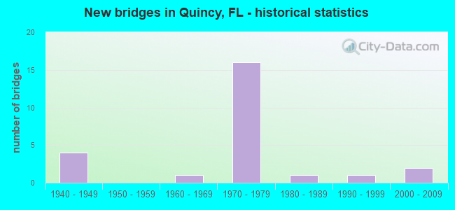
- New bridges - historical statistics
- 41940-1949
- 11960-1969
- 161970-1979
- 11980-1989
- 11990-1999
- 22000-2009


- Bridge Condition - Deck
- 50.0%Good
- 20.0%Satisfactory
- 30.0%Fair

- Bridge Condition - Superstructure
- 60.0%Good
- 10.0%Satisfactory
- 30.0%Fair

- Bridge Condition - Substructure
- 90.0%Good
- 10.0%Fair

- Bridge Condition - Channel
- 11.1%Very good
- 11.1%Good
- 50.0%Satisfactory
- 22.2%Fair
- 5.6%Poor

- Bridge Condition - Culverts
- 16.7%Good
- 33.3%Satisfactory
- 33.3%Fair
- 16.7%Serious
Find on map >> Show street view
Structure Number: 500004, Location: 0.5Mile E. of Quincy (Lat: 30.592475, Lng: -84.563347), Route carried "on" structure: State highway 12, Year Built: 1971, Status: Open, Structure Length: 4.57m (14.99ft), Average Daily Traffic: 4,300 (year 2020), Truck Traffic: 7%, Average Future Daily Traffic: 7,460 (year 2042), Design Load: HL 93, Features Intersected: Quincy Creek
Minimum Vertical Clearance: 30+ m (98+ ft), Kilometerpoint: 1.543, Lanes on structure: 2, Owner: State Highway Agency, Approaching Roadway Width: 9.8m (32.2ft), Skew: 3 degrees, Material/Design: Prestressed concrete, Design/Construction: Stringer/Multi-beam, Number Of Spans In Main Unit: 3, Length of Maximum Span: 15.2m (49.9ft), Curb-To-Curb Width: 13.4m (44.0ft), Out-to-Out Width: 14.2m (46.6ft)
Condition: Deck: Satisfactory, Superstructure: Good, Substructure: Fair, Channel: Fair, Operating Rating: 46.1 metric tons, Method Used To Determine Operating Rating: Load and Resistance Factor (LRFR), Inventory Rating: 35.6 metric tons, Method Used To Determine Inventory Rating: Load and Resistance Factor (LRFR), Structural Evaluation: Somewhat better than minimum adequacy, Deck Geometry: Better than present minimum criteria, Waterway Adequacy: Equal to present desirable criteria, Approach Roadway Alignment: Equal to present desirable criteria, Designated Inspection Frequency: Every 24 months, Underwater Inspection Frequency: Every 24 months, Inspection Date: August 2021, Underwater Inspection Date: August 2021, Deck Structure Type: Other
Find on map >> Show street view
Structure Number: 500009, Location: 0.5 Miles North of SR 12 (Lat: 30.598208, Lng: -84.574061), Route carried "on" structure: City street 65, Year Built: 1940, Status: Open, Structure Length: 1.93m (6.33ft), Average Daily Traffic: 2,700 (year 2020), Truck Traffic: 6%, Average Future Daily Traffic: 2,970 (year 2040), Features Intersected: Quincy Creek
Minimum Vertical Clearance: 30+ m (98+ ft), Kilometerpoint: 0.824, Lanes on structure: 2, Owner: County Highway Agency, Approaching Roadway Width: 7.3m (24.0ft), Material/Design: Concrete, Design/Construction: Culvert, Number Of Spans In Main Unit: 6, Length of Maximum Span: 3.3m (10.8ft)
Condition: Channel: Poor, Culverts: Fair, Inventory Rating: 63.5 metric tons, Method Used To Determine Inventory Rating: Load Factor (LF), Structural Evaluation: Somewhat better than minimum adequacy, Waterway Adequacy: Equal to present desirable criteria, Approach Roadway Alignment: Equal to present desirable criteria, Designated Inspection Frequency: Every 24 months, Underwater Inspection Frequency: Every 12 months, Other Special Inspection Frequency: Every 12 months, Inspection Date: August 2020, Underwater Inspection Date: August 2021, Other Special Inspection Date: August 2021
Find on map >> Show street view
Structure Number: 500027, Location: 3.6Mi. S of I10 (SR8) (Lat: 30.491778, Lng: -84.614750), Route carried "on" structure: State highway 267, Year Built: 1971, Status: Open, Structure Length: 5.18m (16.99ft), Average Daily Traffic: 4,100 (year 2020), Truck Traffic: 6%, Average Future Daily Traffic: 7,114 (year 2042), Design Load: HL 93, Features Intersected: Rocky Comfort Creek
Minimum Vertical Clearance: 30+ m (98+ ft), Kilometerpoint: 13.396, Lanes on structure: 2, Owner: State Highway Agency, Approaching Roadway Width: 10.4m (34.1ft), Material/Design: Prestressed concrete, Design/Construction: Slab, Number Of Spans In Main Unit: 5, Length of Maximum Span: 10.4m (34.1ft), Curb-To-Curb Width: 13.4m (44.0ft), Out-to-Out Width: 14.1m (46.3ft)
Condition: Deck: Fair, Superstructure: Fair, Substructure: Good, Channel: Satisfactory, Operating Rating: 43.1 metric tons, Method Used To Determine Operating Rating: Load and Resistance Factor (LRFR), Inventory Rating: 33.3 metric tons, Method Used To Determine Inventory Rating: Load and Resistance Factor (LRFR), Structural Evaluation: Somewhat better than minimum adequacy, Deck Geometry: Better than present minimum criteria, Waterway Adequacy: Equal to present desirable criteria, Approach Roadway Alignment: Equal to present desirable criteria, Designated Inspection Frequency: Every 24 months, Critical Feature Inspection Frequency: Every 24 months, Inspection Date: August 2021, Critical Feature Inspection Date: August 2021, Deck Structure Type: Concrete Precast Panels, Wearing Surface/Protective System: Wearing Surface: Bituminous
Find on map >> Show street view
Structure Number: 500028, Location: 3.5 Mi. S of I10 SR8 (Lat: 30.492583, Lng: -84.613694), Route carried "on" structure: State highway 267, Year Built: 1971, Status: Open, Structure Length: 3.38m (11.09ft), Average Daily Traffic: 4,100 (year 2020), Truck Traffic: 6%, Average Future Daily Traffic: 7,114 (year 2042), Design Load: HL 93, Features Intersected: Rocky Comfort Creek
Minimum Vertical Clearance: 30+ m (98+ ft), Kilometerpoint: 13.535, Lanes on structure: 2, Owner: State Highway Agency, Approaching Roadway Width: 10.4m (34.1ft), Material/Design: Prestressed concrete, Design/Construction: Slab, Number Of Spans In Main Unit: 3, Length of Maximum Span: 11.3m (37.1ft), Curb-To-Curb Width: 13.4m (44.0ft), Out-to-Out Width: 14.1m (46.3ft)
Condition: Deck: Fair, Superstructure: Fair, Substructure: Good, Channel: Very good, Operating Rating: 42.5 metric tons, Method Used To Determine Operating Rating: Load and Resistance Factor (LRFR), Inventory Rating: 35.9 metric tons, Method Used To Determine Inventory Rating: Load and Resistance Factor (LRFR), Structural Evaluation: Somewhat better than minimum adequacy, Deck Geometry: Better than present minimum criteria, Waterway Adequacy: Equal to present desirable criteria, Approach Roadway Alignment: Equal to present desirable criteria, Designated Inspection Frequency: Every 24 months, Critical Feature Inspection Frequency: Every 24 months, Inspection Date: August 2021, Critical Feature Inspection Date: August 2021, Deck Structure Type: Concrete Precast Panels, Wearing Surface/Protective System: Wearing Surface: Bituminous
Find on map >> Show street view
Structure Number: 500029, Location: 0.9 Miles North of US90 (Lat: 30.600192, Lng: -84.580278), Route carried "on" structure: State highway 267, Year Built: 1948, Status: Open, Structure Length: 1.31m (4.30ft), Average Daily Traffic: 3,700 (year 2020), Truck Traffic: 13%, Average Future Daily Traffic: 6,420 (year 2042), Design Load: HS 20, Features Intersected: Quincy Creek
Minimum Vertical Clearance: 30+ m (98+ ft), Kilometerpoint: 1.413, Lanes on structure: 2, Owner: State Highway Agency, Approaching Roadway Width: 7.3m (24.0ft), Material/Design: Concrete, Design/Construction: Culvert, Number Of Spans In Main Unit: 4, Length of Maximum Span: 3.0m (9.8ft)
Condition: Channel: Fair, Culverts: Satisfactory, Operating Rating: 58.1 metric tons, Method Used To Determine Operating Rating: Load Factor (LF), Inventory Rating: 34.5 metric tons, Method Used To Determine Inventory Rating: Load Factor (LF), Structural Evaluation: Equal to present minimum criteria, Waterway Adequacy: Better than present minimum criteria, Approach Roadway Alignment: Equal to present desirable criteria, Designated Inspection Frequency: Every 24 months, Inspection Date: September 2021
Find on map >> Show street view
Structure Number: 500039, Location: 3.2 Mi South of US90/SR10 (Lat: 30.545647, Lng: -84.635878), Route carried "on" structure: County highway 274, Year Built: 1978, Status: Open, Structure Length: 1.83m (6.00ft), Average Daily Traffic: 2,800 (year 2019), Truck Traffic: 6%, Average Future Daily Traffic: 3,080 (year 2039), Features Intersected: Rocky Comfort Creek
Minimum Vertical Clearance: 30+ m (98+ ft), Kilometerpoint: 11.784, Lanes on structure: 2, Owner: County Highway Agency, Approaching Roadway Width: 6.1m (20.0ft), Material/Design: Steel, Design/Construction: Culvert, Number Of Spans In Main Unit: 3, Length of Maximum Span: 6.4m (21.0ft)
Condition: Channel: Fair, Culverts: Fair, Inventory Rating: 83.5 metric tons, Method Used To Determine Inventory Rating: Allowable Stress (AS), Structural Evaluation: Somewhat better than minimum adequacy, Waterway Adequacy: Equal to present desirable criteria, Approach Roadway Alignment: Equal to present desirable criteria, Designated Inspection Frequency: Every 24 months, Underwater Inspection Frequency: Every 24 months, Inspection Date: January 2021, Underwater Inspection Date: January 2021
Find on map >> Show street view
Structure Number: 500042, Location: 2.0 Miles East of SR 267 (Lat: 30.484675, Lng: -84.593333), Route carried "on" structure: County highway 658, Year Built: 1971, Status: Open, Structure Length: 2.06m (6.76ft), Average Daily Traffic: 350 (year 2020), Truck Traffic: 6%, Average Future Daily Traffic: 385 (year 2040), Features Intersected: Rocky Comfort Creek
Minimum Vertical Clearance: 30+ m (98+ ft), Kilometerpoint: 12.006, Lanes on structure: 2, Owner: County Highway Agency, Approaching Roadway Width: 5.7m (18.7ft), Material/Design: Steel, Design/Construction: Culvert, Number Of Spans In Main Unit: 5, Length of Maximum Span: 4.3m (14.1ft)
Condition: Channel: Fair, Culverts: Serious, Structural Evaluation: High priority of corrective action, Waterway Adequacy: Better than present minimum criteria, Approach Roadway Alignment: Equal to present desirable criteria, Designated Inspection Frequency: Every 24 months, Other Special Inspection Frequency: Every 6 months, Inspection Date: November 2020, Other Special Inspection Date: November 2021
Find on map >> Show street view
Structure Number: 500053, Location: 2.1 Miles East of SR 267 (Lat: 30.486033, Lng: -84.592064), Route carried "on" structure: County highway 658, Year Built: 1971, Status: Open, Structure Length: 1.65m (5.41ft), Average Daily Traffic: 350 (year 2020), Truck Traffic: 6%, Average Future Daily Traffic: 385 (year 2040), Features Intersected: Turkey Creek
Minimum Vertical Clearance: 30+ m (98+ ft), Kilometerpoint: 12.192, Lanes on structure: 2, Owner: County Highway Agency, Approaching Roadway Width: 5.8m (19.0ft), Material/Design: Steel, Design/Construction: Culvert, Number Of Spans In Main Unit: 5, Length of Maximum Span: 3.6m (11.8ft)
Condition: Channel: Satisfactory, Culverts: Fair, Structural Evaluation: Somewhat better than minimum adequacy, Waterway Adequacy: Better than present minimum criteria, Approach Roadway Alignment: Equal to present desirable criteria, Designated Inspection Frequency: Every 24 months, Underwater Inspection Frequency: Every 24 months, Inspection Date: January 2022, Underwater Inspection Date: January 2022
Find on map >> Show street view
Structure Number: 500059, Location: 0.76 Miles West of CR 268 (Lat: 30.521864, Lng: -84.554086), Route carried "on" structure: County highway 658, Year Built: 1971, Status: Open, Structure Length: 1.65m (5.41ft), Average Daily Traffic: 350 (year 2020), Truck Traffic: 6%, Average Future Daily Traffic: 385 (year 2040), Features Intersected: Richlander Creek
Minimum Vertical Clearance: 30+ m (98+ ft), Kilometerpoint: 18.017, Lanes on structure: 2, Owner: County Highway Agency, Approaching Roadway Width: 6.0m (19.7ft), Material/Design: Steel, Design/Construction: Culvert, Number Of Spans In Main Unit: 5, Length of Maximum Span: 4.0m (13.1ft)
Condition: Channel: Satisfactory, Culverts: Serious, Structural Evaluation: High priority of corrective action, Waterway Adequacy: Better than present minimum criteria, Approach Roadway Alignment: Equal to present desirable criteria, Designated Inspection Frequency: Every 24 months, Other Special Inspection Frequency: Every 6 months, Inspection Date: November 2020, Other Special Inspection Date: November 2021
Find on map >> Show street view
Structure Number: 500064, Location: 2.0 miles East of US90 (Lat: 30.594472, Lng: -84.546708), Route carried "on" structure: State highway 12, Year Built: 1948, Year Reconstructed: 1978, Status: Open, Structure Length: 1.24m (4.07ft), Average Daily Traffic: 6,000 (year 2020), Truck Traffic: 9%, Average Future Daily Traffic: 10,410 (year 2042), Design Load: HS 20, Features Intersected: Stream
Minimum Vertical Clearance: 30+ m (98+ ft), Kilometerpoint: 3.230, Lanes on structure: 2, Owner: State Highway Agency, Approaching Roadway Width: 11.0m (36.1ft), Material/Design: Concrete, Design/Construction: Culvert, Number Of Spans In Main Unit: 2, Number Of Approach Spans: 1, Length of Maximum Span: 3.3m (10.8ft)
Condition: Channel: Satisfactory, Culverts: Satisfactory, Operating Rating: 61.3 metric tons, Method Used To Determine Operating Rating: Load Factor (LF), Inventory Rating: 37.1 metric tons, Method Used To Determine Inventory Rating: Load Factor (LF), Structural Evaluation: Equal to present minimum criteria, Waterway Adequacy: Better than present minimum criteria, Approach Roadway Alignment: Equal to present desirable criteria, Designated Inspection Frequency: Every 24 months, Inspection Date: January 2022
Find on map >> Show street view
Structure Number: 500065, Location: 3.1mi. East of US90 (Lat: 30.594667, Lng: -84.530694), Route carried "on" structure: State highway 12, Year Built: 1948, Year Reconstructed: 1978, Status: Open, Structure Length: 0.63m (2.07ft), Average Daily Traffic: 4,200 (year 2020), Truck Traffic: 8%, Average Future Daily Traffic: 7,287 (year 2042), Design Load: HS 20, Features Intersected: Winkley Creek
Minimum Vertical Clearance: 30+ m (98+ ft), Kilometerpoint: 4.971, Lanes on structure: 2, Base Highway Network: Yes, Owner: State Highway Agency, Approaching Roadway Width: 9.8m (32.2ft), Skew: 9 degrees, Material/Design: Concrete, Design/Construction: Culvert, Number Of Spans In Main Unit: 2, Length of Maximum Span: 3.0m (9.8ft)
Condition: Channel: Satisfactory, Culverts: Good, Operating Rating: 61.7 metric tons, Method Used To Determine Operating Rating: Load Factor (LF), Inventory Rating: 37.2 metric tons, Method Used To Determine Inventory Rating: Load Factor (LF), Structural Evaluation: Better than present minimum criteria, Waterway Adequacy: Better than present minimum criteria, Approach Roadway Alignment: Equal to present desirable criteria, Designated Inspection Frequency: Every 24 months, Underwater Inspection Frequency: Every 24 months, Inspection Date: January 2022, Underwater Inspection Date: January 2022
Find on map >> Show street view
Structure Number: 500072, Location: 2.2 Mi South of US90/SR10 (Lat: 30.558319, Lng: -84.567153), Route carried "on" structure: County highway 268, Year Built: 1975, Status: Open, Structure Length: 4.48m (14.70ft), Average Daily Traffic: 4,500 (year 2019), Truck Traffic: 5%, Average Future Daily Traffic: 4,950 (year 2039), Design Load: HS 20, Features Intersected: Seabrd Coast RR
Minimum Vertical Clearance: 30+ m (98+ ft), Kilometerpoint: 3.526, Lanes on structure: 2, Owner: County Highway Agency, Approaching Roadway Width: 6.4m (21.0ft), Material/Design: Prestressed concrete, Design/Construction: Stringer/Multi-beam, Number Of Spans In Main Unit: 3, Length of Maximum Span: 15.1m (49.5ft), Curb-To-Curb Width: 12.1m (39.7ft), Out-to-Out Width: 13.2m (43.3ft)
Condition: Deck: Good, Superstructure: Good, Substructure: Good, Operating Rating: 52.6 metric tons, Method Used To Determine Operating Rating: Allowable Stress (AS), Inventory Rating: 32.7 metric tons, Method Used To Determine Inventory Rating: Allowable Stress (AS), Structural Evaluation: Better than present minimum criteria, Deck Geometry: Somewhat better than minimum adequacy, Underclear: Somewhat better than minimum adequacy, Approach Roadway Alignment: Equal to present minimum criteria, Designated Inspection Frequency: Every 24 months, Inspection Date: January 2021, Deck Structure Type: Concrete Cast-file-Place
Find on map >> Show street view
Structure Number: 50009, Location: 4.4 Mile East of SR12 (Lat: 30.554858, Lng: -84.632422), Route carried "on" structure: County highway 274, Year Built: 1975, Status: Open, Structure Length: 8.35m (27.40ft), Average Daily Traffic: 3,100 (year 2020), Truck Traffic: 7%, Average Future Daily Traffic: 5,378 (year 2042), Design Load: HL 93, Features Intersected: I10 SR8
Minimum Vertical Clearance: 30+ m (98+ ft), Kilometerpoint: 12.852, Lanes on structure: 2, Lanes under structure: 4, Owner: State Highway Agency, Approaching Roadway Width: 6.1m (20.0ft), Skew: 2 degrees, Material/Design: Prestressed concrete, Design/Construction: Stringer/Multi-beam, Number Of Spans In Main Unit: 4, Length of Maximum Span: 29.7m (97.4ft), Curb-To-Curb Width: 13.4m (44.0ft), Out-to-Out Width: 14.1m (46.3ft)
Condition: Deck: Good, Superstructure: Good, Substructure: Good, Operating Rating: 43.5 metric tons, Method Used To Determine Operating Rating: Load and Resistance Factor (LRFR), Inventory Rating: 30.0 metric tons, Method Used To Determine Inventory Rating: Load and Resistance Factor (LRFR), Structural Evaluation: Better than present minimum criteria, Deck Geometry: Better than present minimum criteria, Underclear: Somewhat better than minimum adequacy, Approach Roadway Alignment: Equal to present desirable criteria, Designated Inspection Frequency: Every 24 months, Inspection Date: September 2021, Deck Structure Type: Concrete Cast-file-Place
Find on map >> Show street view
Structure Number: 500099, Location: 3.0MI East of SR267 (Lat: 30.530664, Lng: -84.544922), Route carried "on" structure: County highway 268, Year Built: 1976, Status: Open, Structure Length: 7.96m (26.12ft), Average Daily Traffic: 4,100 (year 2020), Truck Traffic: 7%, Average Future Daily Traffic: 7,114 (year 2042), Design Load: HS 20, Features Intersected: I10 SR8
Minimum Vertical Clearance: 30+ m (98+ ft), Kilometerpoint: 7.409, Lanes on structure: 2, Lanes under structure: 4, Owner: State Highway Agency, Approaching Roadway Width: 9.1m (29.9ft), Skew: 2 degrees, Material/Design: Prestressed concrete, Design/Construction: Stringer/Multi-beam, Number Of Spans In Main Unit: 4, Length of Maximum Span: 29.5m (96.8ft), Curb-To-Curb Width: 9.8m (32.2ft), Out-to-Out Width: 10.4m (34.1ft)
Condition: Deck: Good, Superstructure: Satisfactory, Substructure: Good, Operating Rating: 69.9 metric tons, Method Used To Determine Operating Rating: Load Factor (LF), Inventory Rating: 41.7 metric tons, Method Used To Determine Inventory Rating: Load Factor (LF), Structural Evaluation: Equal to present minimum criteria, Deck Geometry: Meets minimum limits, Underclear: Somewhat better than minimum adequacy, Approach Roadway Alignment: Equal to present desirable criteria, Designated Inspection Frequency: Every 24 months, Inspection Date: Febuary 2022, Deck Structure Type: Concrete Cast-file-Place
Find on map >> Show street view
Structure Number: 5001, Location: 6.0MI East of SR12 (Lat: 30.538469, Lng: -84.595239), Route carried "on" structure: State highway 267, Year Built: 1976, Status: Open, Structure Length: 7.40m (24.28ft), Average Daily Traffic: 7,548 (year 2020), Truck Traffic: 7%, Average Future Daily Traffic: 13,096 (year 2042), Design Load: HS 20+Mod, Features Intersected: I10 SR8
Minimum Vertical Clearance: 30+ m (98+ ft), Kilometerpoint: 19.159, Lanes on structure: 6, Lanes under structure: 4, Owner: State Highway Agency, Approaching Roadway Width: 29.9m (98.1ft), Skew: 20 degrees, Material/Design: Prestressed concrete, Design/Construction: Stringer/Multi-beam, Number Of Spans In Main Unit: 4, Length of Maximum Span: 26.9m (88.3ft), Curb-To-Curb Width: 29.9m (98.1ft), Out-to-Out Width: 30.5m (100.1ft)
Condition: Deck: Good, Superstructure: Good, Substructure: Good, Inventory Rating: 56.2 metric tons, Method Used To Determine Inventory Rating: Load Factor (LF), Structural Evaluation: Better than present minimum criteria, Deck Geometry: Superior to present desirable criteria, Underclear: Somewhat better than minimum adequacy, Approach Roadway Alignment: Equal to present desirable criteria, Designated Inspection Frequency: Every 24 months, Inspection Date: Febuary 2022, Deck Structure Type: Concrete Cast-file-Place
Find on map >> Show street view
Structure Number: 500101, Location: 2.3mi. East of SR267 (Lat: 30.530028, Lng: -84.559528), Route carried "on" structure: Interstate 10, Year Built: 1972, Status: Open, Structure Length: 1.16m (3.81ft), Average Daily Traffic: 29,226 (year 2020), Truck Traffic: 24%, Average Future Daily Traffic: 50,707 (year 2042), Design Load: HS 20, Features Intersected: Richlander Creek
Minimum Vertical Clearance: 30+ m (98+ ft), Kilometerpoint: 37.456, Lanes on structure: 4, Base Highway Network: Yes, Owner: State Highway Agency, Approaching Roadway Width: 23.2m (76.1ft), Skew: 12 degrees, Material/Design: Concrete, Design/Construction: Culvert, Number Of Spans In Main Unit: 3, Length of Maximum Span: 3.7m (12.1ft)
Condition: Channel: Satisfactory, Culverts: Satisfactory, Structural Evaluation: Equal to present minimum criteria, Waterway Adequacy: Better than present minimum criteria, Approach Roadway Alignment: Equal to present desirable criteria, Designated Inspection Frequency: Every 24 months, Inspection Date: Febuary 2020
Find on map >> Show street view
Structure Number: 500111, Location: 1.0mi. West of SR267 (Lat: 30.543614, Lng: -84.610253), Route carried "on" structure: Interstate 10, Year Built: 1972, Status: Open, Structure Length: 0.95m (3.12ft), Average Daily Traffic: 22,500 (year 2020), Truck Traffic: 28%, Average Future Daily Traffic: 39,038 (year 2042), Design Load: HS 20, Features Intersected: Cox Creek
Minimum Vertical Clearance: 30+ m (98+ ft), Kilometerpoint: 32.110, Lanes on structure: 4, Base Highway Network: Yes, Owner: State Highway Agency, Approaching Roadway Width: 23.2m (76.1ft), Skew: 10 degrees, Material/Design: Concrete, Design/Construction: Culvert, Number Of Spans In Main Unit: 3, Length of Maximum Span: 3.0m (9.8ft)
Condition: Channel: Satisfactory, Culverts: Satisfactory, Structural Evaluation: Equal to present minimum criteria, Waterway Adequacy: Better than present minimum criteria, Approach Roadway Alignment: Equal to present desirable criteria, Designated Inspection Frequency: Every 24 months, Inspection Date: Febuary 2020
Find on map >> Show street view
Structure Number: 500117, Location: 4.7Miles South of I10 SR8 (Lat: 30.479761, Lng: -84.625831), Route carried "on" structure: State highway 267, Year Built: 1988, Status: Open, Structure Length: 3.05m (10.01ft), Average Daily Traffic: 3,500 (year 2020), Truck Traffic: 6%, Average Future Daily Traffic: 6,072 (year 2042), Design Load: HL 93, Features Intersected: Bear Creek
Minimum Vertical Clearance: 30+ m (98+ ft), Kilometerpoint: 11.665, Lanes on structure: 2, Owner: State Highway Agency, Approaching Roadway Width: 10.4m (34.1ft), Material/Design: Prestressed concrete, Design/Construction: Stringer/Multi-beam, Number Of Spans In Main Unit: 2, Length of Maximum Span: 15.2m (49.9ft), Curb-To-Curb Width: 13.4m (44.0ft), Out-to-Out Width: 14.3m (46.9ft)
Condition: Deck: Satisfactory, Superstructure: Good, Substructure: Good, Channel: Very good, Operating Rating: 41.2 metric tons, Method Used To Determine Operating Rating: Load and Resistance Factor (LRFR), Inventory Rating: 31.7 metric tons, Method Used To Determine Inventory Rating: Load and Resistance Factor (LRFR), Structural Evaluation: Better than present minimum criteria, Deck Geometry: Better than present minimum criteria, Waterway Adequacy: Better than present minimum criteria, Approach Roadway Alignment: Equal to present desirable criteria, Designated Inspection Frequency: Every 24 months, Inspection Date: Febuary 2022, Deck Structure Type: Concrete Cast-file-Place
Find on map >> Show street view
Structure Number: 50014, Location: 1.3 Mi. East of SR12 (Lat: 30.578611, Lng: -84.558056), Route carried "on" structure: US 90, Year Built: 2003, Status: Open, Structure Length: 1.28m (4.20ft), Average Daily Traffic: 14,100 (year 2020), Truck Traffic: 7%, Average Future Daily Traffic: 24,464 (year 2042), Design Load: H 20, Features Intersected: Quincy Creek
Minimum Vertical Clearance: 30+ m (98+ ft), Kilometerpoint: 2.057, Lanes on structure: 4, Owner: State Highway Agency, Approaching Roadway Width: 18.3m (60.0ft), Skew: 10 degrees, Material/Design: Concrete, Design/Construction: Culvert, Number Of Spans In Main Unit: 1, Length of Maximum Span: 12.8m (42.0ft)
Condition: Channel: Good, Culverts: Good, Inventory Rating: 54.2 metric tons, Method Used To Determine Inventory Rating: Load Factor (LF), Structural Evaluation: Better than present minimum criteria, Waterway Adequacy: Better than present minimum criteria, Approach Roadway Alignment: Equal to present desirable criteria, Designated Inspection Frequency: Every 24 months, Inspection Date: April 2021
Find on map >> Show street view
Structure Number: 50402, Location: 1.87 Mi South of CR 274 (Lat: 30.514017, Lng: -84.654672), Route carried "on" structure: County highway , Year Built: 1960, Status: Open, Structure Length: 1.86m (6.10ft), Average Daily Traffic: 235 (year 2019), Average Future Daily Traffic: 259 (year 2039), Features Intersected: Cane Creek, Facility Carried by Structure: Cane Creek Road
Minimum Vertical Clearance: 30+ m (98+ ft), Kilometerpoint: 1.783, Lanes on structure: 2, Owner: County Highway Agency, Approaching Roadway Width: 6.6m (21.7ft), Material/Design: Steel, Design/Construction: Culvert, Number Of Spans In Main Unit: 3, Length of Maximum Span: 6.2m (20.3ft)
Condition: Channel: Satisfactory, Culverts: Fair, Operating Rating: 49.0 metric tons, Method Used To Determine Operating Rating: Allowable Stress (AS), Inventory Rating: 29.0 metric tons, Method Used To Determine Inventory Rating: Allowable Stress (AS), Structural Evaluation: Somewhat better than minimum adequacy, Waterway Adequacy: Equal to present desirable criteria, Approach Roadway Alignment: Equal to present desirable criteria, Designated Inspection Frequency: Every 24 months, Underwater Inspection Frequency: Every 24 months, Inspection Date: July 2020, Underwater Inspection Date: July 2020
Find on map >> Show street view
Structure Number: 504137, Location: 0.8 Miles North US90/SR10 (Lat: 30.597447, Lng: -84.597103), Route carried "on" structure: County highway , Year Built: 1997, Status: Open, Structure Length: 2.49m (8.17ft), Average Daily Traffic: 2,200 (year 2019), Truck Traffic: 5%, Average Future Daily Traffic: 2,420 (year 2039), Design Load: HS 20, Features Intersected: Quincy Creek, Facility Carried by Structure: CR 268
Minimum Vertical Clearance: 30+ m (98+ ft), Kilometerpoint: 25.663, Lanes on structure: 2, Owner: County Highway Agency, Approaching Roadway Width: 6.1m (20.0ft), Material/Design: Prestressed concrete, Design/Construction: Slab, Number Of Spans In Main Unit: 4, Length of Maximum Span: 6.4m (21.0ft), Curb-To-Curb Width: 9.8m (32.2ft), Out-to-Out Width: 9.8m (32.2ft)
Condition: Deck: Fair, Superstructure: Fair, Substructure: Good, Channel: Satisfactory, Operating Rating: 84.4 metric tons, Method Used To Determine Operating Rating: Load Factor (LF), Inventory Rating: 50.8 metric tons, Method Used To Determine Inventory Rating: Load Factor (LF), Structural Evaluation: Somewhat better than minimum adequacy, Deck Geometry: Meets minimum limits, Waterway Adequacy: Equal to present desirable criteria, Approach Roadway Alignment: Equal to present desirable criteria, Designated Inspection Frequency: Every 24 months, Inspection Date: April 2021, Deck Structure Type: Concrete Precast Panels, Wearing Surface/Protective System: Wearing Surface: Bituminous
Find on map >> Show street view
Structure Number: 504143, Location: 0.8 Miles South of CR 65B (Lat: 30.470939, Lng: -84.591958), Route carried "on" structure: County highway , Year Built: 2008, Status: Open, Structure Length: 1.19m (3.90ft), Average Daily Traffic: 88 (year 2019), Average Future Daily Traffic: 97 (year 2039), Design Load: HS 20, Features Intersected: Bear Creek, Facility Carried by Structure: Bear Creek Road
Minimum Vertical Clearance: 30+ m (98+ ft), Kilometerpoint: 1.436, Lanes on structure: 2, Owner: County Highway Agency, Approaching Roadway Width: 6.1m (20.0ft), Material/Design: Concrete, Design/Construction: Slab, Number Of Spans In Main Unit: 1, Length of Maximum Span: 11.9m (39.0ft), Curb-To-Curb Width: 7.6m (24.9ft), Out-to-Out Width: 8.6m (28.2ft)
Condition: Deck: Good, Superstructure: Good, Substructure: Good, Channel: Good, Operating Rating: 74.4 metric tons, Method Used To Determine Operating Rating: Load Factor (LF), Inventory Rating: 44.5 metric tons, Method Used To Determine Inventory Rating: Load Factor (LF), Structural Evaluation: Better than present minimum criteria, Deck Geometry: Equal to present minimum criteria, Waterway Adequacy: Better than present minimum criteria, Approach Roadway Alignment: Equal to present desirable criteria, Designated Inspection Frequency: Every 24 months, Inspection Date: January 2021, Deck Structure Type: Concrete Cast-file-Place
Find on map >> Show street view
Structure Number: 50009, Location: 4.4 Mile East of SR12 (Lat: 30.554858, Lng: -84.632422), Route carried "under" structure: Interstate 10, Year Built: 1975, Structure Length: 0. m, Average Daily Traffic: 22,500 (year 2020), Truck Traffic: 28%, Features Intersected: I10 SR8, Facility Carried by Structure: CR274
Minimum Vertical Clearance: 4.82m (15.81ft), Kilometerpoint: 29.594, Lanes on structure: 2, Lanes under structure: 4, Material/Design: Prestressed concrete, Design/Construction: Stringer/Multi-beam, Length of Maximum Span: 29.7m (97.4ft)
Find on map >> Show street view
Structure Number: 500099, Location: 3.0MI East of SR267 (Lat: 30.530664, Lng: -84.544922), Route carried "under" structure: Interstate 10, Year Built: 1976, Structure Length: 0. m, Average Daily Traffic: 29,226 (year 2020), Truck Traffic: 24%, Features Intersected: I10 SR8, Facility Carried by Structure: CR268
Minimum Vertical Clearance: 4.88m (16.01ft), Kilometerpoint: 38.608, Lanes on structure: 2, Lanes under structure: 4, Material/Design: Prestressed concrete, Design/Construction: Stringer/Multi-beam, Length of Maximum Span: 29.5m (96.8ft)
Find on map >> Show street view
Structure Number: 5001, Location: 6.0MI East of SR12 (Lat: 30.538469, Lng: -84.595239), Route carried "under" structure: Interstate 10, Year Built: 1976, Structure Length: 0. m, Average Daily Traffic: 29,226 (year 2020), Truck Traffic: 24%, Features Intersected: I10 SR8, Facility Carried by Structure: SR267
Minimum Vertical Clearance: 4.88m (16.01ft), Kilometerpoint: 33.618, Lanes on structure: 6, Lanes under structure: 4, Material/Design: Prestressed concrete, Design/Construction: Stringer/Multi-beam, Length of Maximum Span: 26.9m (88.3ft)