Bridge Statistics for Potomac, Maryland (MD)
Condition, Traffic, Stress, Structural Evaluation, Project Costs
- National Bridge Inventory (NBI) Statistics
- 35Number of bridges
- 299ft / 90.8mTotal length
- $2,248,000Total costs
- 1,019,980Total average daily traffic
- 38,358Total average daily truck traffic
- National Bridge Inventory (NBI) Registered Bridges for Potomac
- No street view available for this location
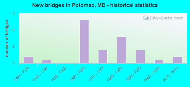
- New bridges - historical statistics
- 21930-1939
- 11940-1949
- 131960-1969
- 41970-1979
- 81980-1989
- 41990-1999
- 12000-2009
- 22010-2019

- Reconstructed bridges - Historical Statistics
- 11960-1969
- 11970-1979
- 41980-1989
- 21990-1999
- 12000-2009


- Bridge Condition - Deck
- 5.6%Very good
- 33.3%Good
- 44.4%Satisfactory
- 16.7%Fair

- Bridge Condition - Superstructure
- 5.6%Very good
- 38.9%Good
- 38.9%Satisfactory
- 16.7%Fair

- Bridge Condition - Substructure
- 11.1%Very good
- 22.2%Good
- 44.4%Satisfactory
- 22.2%Fair

- Bridge Condition - Channel
- 9.1%Very good
- 18.2%Good
- 31.8%Satisfactory
- 27.3%Fair
- 13.6%Poor

- Bridge Condition - Culverts
- 10.0%Good
- 60.0%Satisfactory
- 30.0%Fair
Find on map >> Show street view
Structure Number: 10000015002701, Location: 0.74 MILE EAST OF MD 191 (Lat: 38.996886, Lng: -77.169236), Route carried "on" structure: State highway 190, Year Built: 1974, Status: Open, Structure Length: 2.90m (9.51ft), Average Daily Traffic: 22,022 (year 2018), Truck Traffic: 8%, Average Future Daily Traffic: 22,062 (year 2038), Design Load: HS 20, Features Intersected: CABIN JOHN CREEK
Minimum Vertical Clearance: 30+ m (98+ ft), Kilometerpoint: 17.294, Lanes on structure: 2, Base Highway Network: Yes, Owner: State Highway Agency, Approaching Roadway Width: 13.4m (44.0ft), Skew: 1 degrees, Material/Design: Steel, Design/Construction: Stringer/Multi-beam, Number Of Spans In Main Unit: 1, Length of Maximum Span: 27.4m (89.9ft), Curb-To-Curb Width: 13.4m (44.0ft), Out-to-Out Width: 14.4m (47.2ft)
Condition: Deck: Satisfactory, Superstructure: Good, Substructure: Good, Channel: Very good, Operating Rating: 86.2 metric tons, Method Used To Determine Operating Rating: Load Factor (LF), Inventory Rating: 51.7 metric tons, Method Used To Determine Inventory Rating: Load Factor (LF), Structural Evaluation: Better than present minimum criteria, Deck Geometry: Equal to present minimum criteria, Waterway Adequacy: Superior to present desirable criteria, Approach Roadway Alignment: Equal to present desirable criteria, Designated Inspection Frequency: Every 24 months, Inspection Date: May 2020, Deck Structure Type: Concrete Cast-file-Place, Wearing Surface/Protective System: Wearing Surface: Monolithic Concrete
Find on map >> Show street view
Structure Number: 10000015002902, Location: 0.96 MILE SOUTH OF IS 495 (Lat: 39.009686, Lng: -77.167272), Route carried "on" structure: State highway 191, Year Built: 1991, Status: Open, Structure Length: 0.85m (2.79ft), Average Daily Traffic: 8,530 (year 2009), Truck Traffic: 2%, Average Future Daily Traffic: 9,847 (year 2026), Features Intersected: CABIN JOHN CREEK
Minimum Vertical Clearance: 30+ m (98+ ft), Kilometerpoint: 1.512, Lanes on structure: 2, Owner: State Highway Agency, Approaching Roadway Width: 12.2m (40.0ft), Material/Design: Concrete, Design/Construction: Culvert, Number Of Spans In Main Unit: 2, Length of Maximum Span: 4.0m (13.1ft), Curb-To-Curb Width: 12.2m (40.0ft), Out-to-Out Width: 12.9m (42.3ft)
Condition: Channel: Fair, Culverts: Satisfactory, Operating Rating: 54.4 metric tons, Method Used To Determine Operating Rating: Allowable Stress (AS), Inventory Rating: 43.5 metric tons, Method Used To Determine Inventory Rating: Allowable Stress (AS), Structural Evaluation: Equal to present minimum criteria, Deck Geometry: Somewhat better than minimum adequacy, Waterway Adequacy: Equal to present desirable criteria, Approach Roadway Alignment: Equal to present desirable criteria, Designated Inspection Frequency: Every 24 months, Inspection Date: October 2020, Wearing Surface/Protective System: Wearing Surface: Bituminous, Deck Protection: Epoxy Coated Reinforcing
Find on map >> Show street view
Structure Number: 10000015006801, Location: 1.36 MILES S OF MD 189 (Lat: 39.056389, Lng: -77.154839), Route carried "on" structure: State highway 927, Year Built: 1988, Status: Open, Structure Length: 9.57m (31.40ft), Average Daily Traffic: 10,211 (year 2018), Truck Traffic: 5%, Average Future Daily Traffic: 10,229 (year 2038), Design Load: HS 20, Features Intersected: IS 270 & C-D ROADS
Minimum Vertical Clearance: 30+ m (98+ ft), Kilometerpoint: 2.220, Lanes on structure: 6, Lanes under structure: 14, Base Highway Network: Yes, Owner: State Highway Agency, Approaching Roadway Width: 28.7m (94.2ft), Skew: 22 degrees, Material/Design: Steel continuous, Design/Construction: Stringer/Multi-beam, Number Of Spans In Main Unit: 4, Length of Maximum Span: 24.7m (81.0ft), Curb or Sidewalk Widths: Left: 1.9m (6.2ft), Right: 1.9m (6.2ft), Curb-To-Curb Width: 28.7m (94.2ft), Out-to-Out Width: 33.0m (108.3ft)
Condition: Deck: Satisfactory, Superstructure: Good, Substructure: Good, Operating Rating: 63.5 metric tons, Method Used To Determine Operating Rating: Load Factor (LF), Inventory Rating: 38.1 metric tons, Method Used To Determine Inventory Rating: Load Factor (LF), Structural Evaluation: Better than present minimum criteria, Deck Geometry: Superior to present desirable criteria, Underclear: Meets minimum limits, Approach Roadway Alignment: Equal to present desirable criteria, Designated Inspection Frequency: Every 24 months, Inspection Date: December 2021, Deck Structure Type: Concrete Cast-file-Place, Wearing Surface/Protective System: Wearing Surface: Monolithic Concrete, Deck Protection: Epoxy Coated Reinforcing
Find on map >> Show street view
Structure Number: 10000015010301, Location: 0.55 MI W OF MD 191 (Lat: 38.974731, Lng: -77.178914), Route carried "on" structure: Ramp Interstate 495, Year Built: 1963, Year Reconstructed: 2008, Status: Open, Structure Length: 6.71m (22.01ft), Average Daily Traffic: 7,000 (year 2006), Truck Traffic: 2%, Average Future Daily Traffic: 11,000 (year 2026), Design Load: HS 20, Features Intersected: CLARA BARTON PKWY WBR
Minimum Vertical Clearance: 30+ m (98+ ft), Kilometerpoint: 0.483, Lanes on structure: 1, Lanes under structure: 3, Base Highway Network: Yes, Owner: State Highway Agency, Approaching Roadway Width: 6.1m (20.0ft), Skew: 9 degrees, Material/Design: Steel, Design/Construction: Stringer/Multi-beam, Number Of Spans In Main Unit: 4, Length of Maximum Span: 22.3m (73.2ft), Curb-To-Curb Width: 7.5m (24.6ft), Out-to-Out Width: 8.7m (28.5ft)
Condition: Deck: Very good, Superstructure: Satisfactory, Substructure: Satisfactory, Inventory Rating: 54.9 metric tons, Method Used To Determine Inventory Rating: Load Factor (LF), Structural Evaluation: Equal to present minimum criteria, Deck Geometry: Better than present minimum criteria, Underclear: High priority of corrective action, Approach Roadway Alignment: Equal to present desirable criteria, Designated Inspection Frequency: Every 24 months, Inspection Date: April 2021, Deck Structure Type: Concrete Cast-file-Place, Wearing Surface/Protective System: Wearing Surface: Integral Concrete, Deck Protection: Epoxy Coated Reinforcing
Find on map >> Show street view
Structure Number: 10000015010701, Location: 0.12 MI W OF IS 495X (Lat: 38.985719, Lng: -77.158847), Route carried "on" structure: Ramp Interstate 495, Year Built: 1964, Year Reconstructed: 1991, Status: Open, Structure Length: 8.96m (29.40ft), Average Daily Traffic: 11,731 (year 2006), Truck Traffic: 8%, Average Future Daily Traffic: 12,669 (year 2026), Design Load: HS 20+Mod, Features Intersected: CABIN JOHN CREEK
Minimum Vertical Clearance: 30+ m (98+ ft), Kilometerpoint: 0.161, Lanes on structure: 1, Base Highway Network: Yes, Owner: State Highway Agency, Approaching Roadway Width: 7.3m (24.0ft), Skew: 5 degrees, Material/Design: Steel, Design/Construction: Stringer/Multi-beam, Number Of Spans In Main Unit: 4, Length of Maximum Span: 23.5m (77.1ft), Curb-To-Curb Width: 7.5m (24.6ft), Out-to-Out Width: 8.7m (28.5ft)
Condition: Deck: Satisfactory, Superstructure: Satisfactory, Substructure: Satisfactory, Channel: Poor, Inventory Rating: 65.3 metric tons, Method Used To Determine Inventory Rating: Load Factor (LF), Structural Evaluation: Equal to present minimum criteria, Deck Geometry: Better than present minimum criteria, Waterway Adequacy: Equal to present desirable criteria, Approach Roadway Alignment: Equal to present minimum criteria, Length Of Structure Improvement: 8.81m (28.90ft), Designated Inspection Frequency: Every 24 months, Inspection Date: May 2020, Bridge Improvement Cost: $506,000, Roadway Improvement Cost: $51,000, Total Project Cost: $557,000, Deck Structure Type: Concrete Cast-file-Place, Wearing Surface/Protective System: Wearing Surface: Bituminous, Deck Protection: Epoxy Coated Reinforcing
Find on map >> Show street view
Structure Number: 10000015011001, Location: 1.19 MILES WEST OF MD 188 (Lat: 38.991067, Lng: -77.157817), Route carried "on" structure: State highway 190, Year Built: 1962, Year Reconstructed: 1970, Status: Open, Structure Length: 9.57m (31.40ft), Average Daily Traffic: 22,022 (year 2018), Truck Traffic: 8%, Average Future Daily Traffic: 22,062 (year 2038), Design Load: HS 20, Features Intersected: IS 495
Minimum Vertical Clearance: 30+ m (98+ ft), Kilometerpoint: 18.536, Lanes on structure: 6, Lanes under structure: 10, Base Highway Network: Yes, Owner: State Highway Agency, Approaching Roadway Width: 29.3m (96.1ft), Skew: 21 degrees, Material/Design: Steel continuous, Design/Construction: Stringer/Multi-beam, Number Of Spans In Main Unit: 4, Length of Maximum Span: 26.2m (86.0ft), Curb-To-Curb Width: 29.3m (96.1ft), Out-to-Out Width: 30.9m (101.4ft)
Condition: Deck: Good, Superstructure: Satisfactory, Substructure: Satisfactory, Operating Rating: 52.6 metric tons, Method Used To Determine Operating Rating: Load Factor (LF), Inventory Rating: 31.3 metric tons, Method Used To Determine Inventory Rating: Load Factor (LF), Structural Evaluation: Equal to present minimum criteria, Deck Geometry: Superior to present desirable criteria, Underclear: Somewhat better than minimum adequacy, Approach Roadway Alignment: Equal to present desirable criteria, Designated Inspection Frequency: Every 24 months, Inspection Date: April 2021, Deck Structure Type: Concrete Cast-file-Place, Wearing Surface/Protective System: Wearing Surface: Bituminous
Find on map >> Show street view
Structure Number: 10000015011101, Location: 1.9 MILES NORTH OF MD 190 (Lat: 39.009522, Lng: -77.152567), Route carried "on" structure: State highway 191, Year Built: 1962, Year Reconstructed: 1971, Status: Open, Structure Length: 10.45m (34.28ft), Average Daily Traffic: 10,370 (year 2009), Truck Traffic: 8%, Average Future Daily Traffic: 13,156 (year 2026), Design Load: HS 20, Features Intersected: IS 495 & THOMAS BRANCH
Minimum Vertical Clearance: 30+ m (98+ ft), Kilometerpoint: 3.057, Lanes on structure: 2, Lanes under structure: 12, Owner: State Highway Agency, Approaching Roadway Width: 21.9m (71.9ft), Skew: 20 degrees, Material/Design: Steel, Design/Construction: Stringer/Multi-beam, Number Of Spans In Main Unit: 3, Number Of Approach Spans: 1, Length of Maximum Span: 32.9m (107.9ft), Curb-To-Curb Width: 17.7m (58.1ft), Out-to-Out Width: 19.3m (63.3ft)
Condition: Deck: Fair, Superstructure: Fair, Substructure: Fair, Channel: Very good, Operating Rating: 75.7 metric tons, Method Used To Determine Operating Rating: Load Factor (LF), Inventory Rating: 45.4 metric tons, Method Used To Determine Inventory Rating: Load Factor (LF), Structural Evaluation: Somewhat better than minimum adequacy, Deck Geometry: Superior to present desirable criteria, Underclear: Meets minimum limits, Waterway Adequacy: Superior to present desirable criteria, Approach Roadway Alignment: Equal to present desirable criteria, Designated Inspection Frequency: Every 24 months, Inspection Date: January 2021, Deck Structure Type: Concrete Cast-file-Place, Wearing Surface/Protective System: Wearing Surface: Bituminous
Find on map >> Show street view
Structure Number: 10000015014301, Location: 0.58 MI E OF VA LINE (Lat: 38.976014, Lng: -77.178519), Route carried "on" structure: Ramp Interstate 495, Year Built: 1963, Year Reconstructed: 1991, Status: Open, Structure Length: 10.24m (33.60ft), Average Daily Traffic: 1,475 (year 2006), Truck Traffic: 8%, Average Future Daily Traffic: 1,593 (year 2026), Design Load: HS 20+Mod, Features Intersected: MACARTHUR BOULEVARD
Minimum Vertical Clearance: 30+ m (98+ ft), Kilometerpoint: 0.064, Lanes on structure: 1, Lanes under structure: 2, Base Highway Network: Yes, Owner: State Highway Agency, Approaching Roadway Width: 7.3m (24.0ft), Skew: 9 degrees, Material/Design: Steel, Design/Construction: Stringer/Multi-beam, Number Of Spans In Main Unit: 3, Number Of Approach Spans: 1, Length of Maximum Span: 32.6m (107.0ft), Curb-To-Curb Width: 7.4m (24.3ft), Out-to-Out Width: 8.6m (28.2ft)
Condition: Deck: Satisfactory, Superstructure: Satisfactory, Substructure: Satisfactory, Operating Rating: 39.0 metric tons, Method Used To Determine Operating Rating: Load Factor (LF), Inventory Rating: 23.1 metric tons, Method Used To Determine Inventory Rating: Load Factor (LF), Structural Evaluation: Somewhat better than minimum adequacy, Deck Geometry: Better than present minimum criteria, Underclear: High priority of corrective action, Approach Roadway Alignment: Equal to present minimum criteria, Length Of Structure Improvement: 10.24m (33.60ft), Designated Inspection Frequency: Every 24 months, Inspection Date: May 2020, Bridge Improvement Cost: $569,000, Roadway Improvement Cost: $57,000, Total Project Cost: $626,000, Deck Structure Type: Concrete Cast-file-Place, Wearing Surface/Protective System: Wearing Surface: Bituminous
Find on map >> Show street view
Structure Number: 200000M-001201, Location: 1 MI SOUTH OF MD 189 (Lat: 39.003728, Lng: -77.214275), Route carried "on" structure: County highway 189, Year Built: 1989, Status: Open, Structure Length: 1.46m (4.79ft), Average Daily Traffic: 3,785 (year 2019), Truck Traffic: 5%, Average Future Daily Traffic: 5,790 (year 2039), Design Load: HS 20, Features Intersected: ROCK RUN, Facility Carried by Structure: OAKLYN DRIVE
Minimum Vertical Clearance: 30+ m (98+ ft), Kilometerpoint: 0.000, Lanes on structure: 2, Owner: County Highway Agency, Approaching Roadway Width: 13.4m (44.0ft), Skew: 3 degrees, Material/Design: Concrete continuous, Design/Construction: Slab, Number Of Spans In Main Unit: 2, Length of Maximum Span: 7.0m (23.0ft), Curb-To-Curb Width: 13.4m (44.0ft), Out-to-Out Width: 14.4m (47.2ft)
Condition: Deck: Good, Superstructure: Good, Substructure: Satisfactory, Channel: Satisfactory, Operating Rating: 83.0 metric tons, Method Used To Determine Operating Rating: Load Factor (LF), Inventory Rating: 49.4 metric tons, Method Used To Determine Inventory Rating: Load Factor (LF), Structural Evaluation: Equal to present minimum criteria, Deck Geometry: Better than present minimum criteria, Waterway Adequacy: Equal to present minimum criteria, Approach Roadway Alignment: Equal to present desirable criteria, Designated Inspection Frequency: Every 24 months, Inspection Date: December 2020, Deck Structure Type: Concrete Cast-file-Place, Wearing Surface/Protective System: Wearing Surface: Integral Concrete, Membrane: Epoxy, Deck Protection: Epoxy Coated Reinforcing
Find on map >> Show street view
Structure Number: 200000M-001301, Location: 1.5 MI WEST OF MD 189 (Lat: 39.045986, Lng: -77.217058), Route carried "on" structure: County highway 195, Year Built: 1942, Year Reconstructed: 1992, Status: Posted for load, Structure Length: 0.86m (2.82ft), Average Daily Traffic: 5,773 (year 2019), Truck Traffic: 3%, Average Future Daily Traffic: 6,519 (year 2039), Design Load: H 15, Features Intersected: KILGOUR BRANCH, Facility Carried by Structure: GLEN ROAD
Minimum Vertical Clearance: 30+ m (98+ ft), Kilometerpoint: 2.784, Lanes on structure: 2, Owner: County Highway Agency, Approaching Roadway Width: 5.8m (19.0ft), Material/Design: Steel, Design/Construction: Stringer/Multi-beam, Number Of Spans In Main Unit: 1, Length of Maximum Span: 8.2m (26.9ft), Curb-To-Curb Width: 5.9m (19.4ft), Out-to-Out Width: 6.2m (20.3ft)
Condition: Deck: Fair, Superstructure: Fair, Substructure: Fair, Channel: Satisfactory, Operating Rating: 23.6 metric tons, Method Used To Determine Operating Rating: Load Factor (LF), Inventory Rating: 13.6 metric tons, Method Used To Determine Inventory Rating: Load Factor (LF), Structural Evaluation: High priority of replacement, Deck Geometry: High priority of replacement, Waterway Adequacy: Equal to present minimum criteria, Approach Roadway Alignment: High priority of corrective action, Bridge Posting: Required (Relationship of Operating Rating to Maximum Legal Load: 20.0 - 29.9% below), Length Of Structure Improvement: 1.59m (5.22ft), Designated Inspection Frequency: Every 12 months, Inspection Date: Febuary 2021, Bridge Improvement Cost: $202,000, Roadway Improvement Cost: $20,000, Total Project Cost: $303,000, Deck Structure Type: Corrugated Steel, Wearing Surface/Protective System: Wearing Surface: Bituminous
Find on map >> Show street view
Structure Number: 200000M-001401, Location: 1.5 MI W OF JCT SR 189 (Lat: 39.046150, Lng: -77.217678), Route carried "on" structure: County highway 195, Year Built: 1930, Year Reconstructed: 1998, Status: Open, Structure Length: 1.23m (4.04ft), Average Daily Traffic: 8,250 (year 2017), Truck Traffic: 3%, Average Future Daily Traffic: 9,380 (year 2037), Design Load: HS 20, Features Intersected: WATTS BRANCH, Facility Carried by Structure: GLEN ROAD
Minimum Vertical Clearance: 30+ m (98+ ft), Kilometerpoint: 2.381, Lanes on structure: 1, Owner: County Highway Agency, Approaching Roadway Width: 5.5m (18.0ft), Material/Design: Steel, Design/Construction: Stringer/Multi-beam, Number Of Spans In Main Unit: 1, Length of Maximum Span: 11.3m (37.1ft), Curb-To-Curb Width: 4.4m (14.4ft), Out-to-Out Width: 4.9m (16.1ft)
Condition: Deck: Satisfactory, Superstructure: Satisfactory, Substructure: Fair, Channel: Fair, Inventory Rating: 85.7 metric tons, Method Used To Determine Inventory Rating: Load Factor (LF), Structural Evaluation: Somewhat better than minimum adequacy, Deck Geometry: High priority of replacement, Waterway Adequacy: Somewhat better than minimum adequacy, Approach Roadway Alignment: High priority of corrective action, Length Of Structure Improvement: 1.22m (4.00ft), Designated Inspection Frequency: Every 24 months, Inspection Date: June 2020, Bridge Improvement Cost: $40,000, Roadway Improvement Cost: $4,000, Total Project Cost: $44,000, Deck Structure Type: Corrugated Steel, Wearing Surface/Protective System: Wearing Surface: Bituminous
Find on map >> Show street view
Structure Number: 200000M-001501, Location: 0.6 MI W OF GLEN MILL RD (Lat: 39.047128, Lng: -77.226481), Route carried "on" structure: County highway 53, Year Built: 1935, Status: Posted for load, Structure Length: 0.79m (2.59ft), Average Daily Traffic: 4,535 (year 2018), Truck Traffic: 5%, Average Future Daily Traffic: 5,184 (year 2038), Features Intersected: PINEY BRANCH, Facility Carried by Structure: GLEN ROAD
Minimum Vertical Clearance: 30+ m (98+ ft), Kilometerpoint: 3.475, Lanes on structure: 2, Owner: County Highway Agency, Approaching Roadway Width: 6.4m (21.0ft), Material/Design: Concrete, Design/Construction: Tee Beam, Number Of Spans In Main Unit: 1, Length of Maximum Span: 6.7m (22.0ft), Curb-To-Curb Width: 6.1m (20.0ft), Out-to-Out Width: 7.2m (23.6ft)
Condition: Deck: Fair, Superstructure: Fair, Substructure: Satisfactory, Channel: Poor, Inventory Rating: 59.0 metric tons, Method Used To Determine Inventory Rating: Load Factor (LF), Structural Evaluation: Somewhat better than minimum adequacy, Deck Geometry: High priority of replacement, Waterway Adequacy: Somewhat better than minimum adequacy, Approach Roadway Alignment: Equal to present desirable criteria, Length Of Structure Improvement: 0.79m (2.59ft), Designated Inspection Frequency: Every 24 months, Inspection Date: March 2021, Bridge Improvement Cost: $75,000, Roadway Improvement Cost: $8,000, Total Project Cost: $83,000, Deck Structure Type: Concrete Cast-file-Place, Wearing Surface/Protective System: Wearing Surface: Bituminous
Find on map >> Show street view
Structure Number: 200000M-001601, Location: 0.6 MI N OF GLEN RD. (Lat: 39.053869, Lng: -77.217139), Route carried "on" structure: County highway 193, Year Built: 1960, Year Reconstructed: 2002, Status: Open, Structure Length: 0.88m (2.89ft), Average Daily Traffic: 4,190 (year 2017), Truck Traffic: 3%, Average Future Daily Traffic: 4,740 (year 2037), Design Load: HS 20, Features Intersected: PINEY BRANCH, Facility Carried by Structure: GLEN MILL ROAD
Minimum Vertical Clearance: 30+ m (98+ ft), Kilometerpoint: 0.917, Lanes on structure: 2, Owner: County Highway Agency, Approaching Roadway Width: 6.7m (22.0ft), Material/Design: Steel, Design/Construction: Stringer/Multi-beam, Number Of Spans In Main Unit: 1, Length of Maximum Span: 8.2m (26.9ft), Curb-To-Curb Width: 9.6m (31.5ft), Out-to-Out Width: 10.2m (33.5ft)
Condition: Deck: Satisfactory, Superstructure: Satisfactory, Substructure: Satisfactory, Channel: Fair, Operating Rating: 68.5 metric tons, Method Used To Determine Operating Rating: Load Factor (LF), Inventory Rating: 40.8 metric tons, Method Used To Determine Inventory Rating: Load Factor (LF), Structural Evaluation: Equal to present minimum criteria, Deck Geometry: Meets minimum limits, Waterway Adequacy: Better than present minimum criteria, Approach Roadway Alignment: Equal to present minimum criteria, Designated Inspection Frequency: Every 24 months, Inspection Date: June 2020, Deck Structure Type: Corrugated Steel, Wearing Surface/Protective System: Wearing Surface: Bituminous
Find on map >> Show street view
Structure Number: 200000M-002101, Location: 0.8 MILES NORTH OF MD 190 (Lat: 39.040119, Lng: -77.234314), Route carried "on" structure: County highway 197, Year Built: 2017, Status: Open, Structure Length: 2.23m (7.32ft), Average Daily Traffic: 6,712 (year 2021), Truck Traffic: 3%, Average Future Daily Traffic: 7,572 (year 2041), Features Intersected: WATTS BRANCH, Facility Carried by Structure: PINEY MEETINGHOUSE
Minimum Vertical Clearance: 30+ m (98+ ft), Kilometerpoint: 0.998, Lanes on structure: 2, Owner: County Highway Agency, Approaching Roadway Width: 9.8m (32.2ft), Skew: 3 degrees, Material/Design: Prestressed concrete, Design/Construction: Tee Beam, Number Of Spans In Main Unit: 1, Length of Maximum Span: 21.6m (70.9ft), Curb or Sidewalk Widths: Left: 0.6m (2.0ft), Right: 0.6m (2.0ft), Curb-To-Curb Width: 9.8m (32.2ft), Out-to-Out Width: 11.0m (36.1ft)
Condition: Deck: Good, Superstructure: Good, Substructure: Very good, Channel: Good, Operating Rating: 53.8 metric tons, Method Used To Determine Operating Rating: Load and Resistance Factor Rating (LRFR) rating reported by rating factor(RF) method using HL-93 loadings, Inventory Rating: 41.5 metric tons, Method Used To Determine Inventory Rating: Load and Resistance Factor Rating (LRFR) rating reported by rating factor(RF) method using HL-93 loadings, Structural Evaluation: Better than present minimum criteria, Deck Geometry: Meets minimum limits, Waterway Adequacy: Better than present minimum criteria, Approach Roadway Alignment: Equal to present desirable criteria, Designated Inspection Frequency: Every 24 months, Inspection Date: September 2021, Deck Structure Type: Concrete Cast-file-Place, Wearing Surface/Protective System: Wearing Surface: Monolithic Concrete
Find on map >> Show street view
Structure Number: 200000M-011001, Location: 0.1 MI S OF JCT SR MD 190 (Lat: 38.990572, Lng: -77.161203), Route carried "on" structure: County highway 148, Year Built: 1980, Status: Open, Structure Length: 2.59m (8.50ft), Average Daily Traffic: 9,886 (year 2021), Truck Traffic: 5%, Average Future Daily Traffic: 11,164 (year 2041), Design Load: HS 20, Features Intersected: CABIN JOHN CREEK, Facility Carried by Structure: SEVEN LOCKS ROAD
Minimum Vertical Clearance: 30+ m (98+ ft), Kilometerpoint: 1.287, Lanes on structure: 2, Owner: County Highway Agency, Approaching Roadway Width: 7.9m (25.9ft), Skew: 1 degrees, Material/Design: Steel, Design/Construction: Stringer/Multi-beam, Number Of Spans In Main Unit: 1, Length of Maximum Span: 24.4m (80.1ft), Curb or Sidewalk Widths: Left: 0.0m, Right: 2.1m (6.9ft), Curb-To-Curb Width: 7.9m (25.9ft), Out-to-Out Width: 11.0m (36.1ft)
Condition: Deck: Satisfactory, Superstructure: Good, Substructure: Satisfactory, Channel: Good, Operating Rating: 74.8 metric tons, Method Used To Determine Operating Rating: Load Factor (LF), Inventory Rating: 44.9 metric tons, Method Used To Determine Inventory Rating: Load Factor (LF), Structural Evaluation: Equal to present minimum criteria, Deck Geometry: High priority of replacement, Waterway Adequacy: Better than present minimum criteria, Approach Roadway Alignment: Equal to present desirable criteria, Length Of Structure Improvement: 2.59m (8.50ft), Designated Inspection Frequency: Every 24 months, Inspection Date: August 2021, Bridge Improvement Cost: $9,000, Total Project Cost: $9,000, Deck Structure Type: Concrete Cast-file-Place, Wearing Surface/Protective System: Wearing Surface: Integral Concrete, Deck Protection: Epoxy Coated Reinforcing
Find on map >> Show street view
Structure Number: 200000M-014502, Location: 1 MI E OF SEVEN LOCKS RD (Lat: 39.036672, Lng: -77.154289), Route carried "on" structure: County highway 164, Year Built: 1966, Status: Open, Structure Length: 1.80m (5.91ft), Average Daily Traffic: 23,120 (year 2019), Truck Traffic: 5%, Average Future Daily Traffic: 26,180 (year 2039), Design Load: HS 20, Features Intersected: CABIN JOHN CREEK, Facility Carried by Structure: TUCKERMAN LANE
Minimum Vertical Clearance: 30+ m (98+ ft), Kilometerpoint: 2.639, Lanes on structure: 2, Owner: County Highway Agency, Approaching Roadway Width: 13.4m (44.0ft), Material/Design: Concrete, Design/Construction: Culvert, Number Of Spans In Main Unit: 4, Length of Maximum Span: 4.3m (14.1ft), Curb-To-Curb Width: 13.4m (44.0ft), Out-to-Out Width: 14.0m (45.9ft)
Condition: Channel: Fair, Culverts: Satisfactory, Inventory Rating: 68.0 metric tons, Method Used To Determine Inventory Rating: Load Factor (LF), Structural Evaluation: Equal to present minimum criteria, Deck Geometry: Equal to present minimum criteria, Waterway Adequacy: Equal to present minimum criteria, Approach Roadway Alignment: Equal to present desirable criteria, Designated Inspection Frequency: Every 24 months, Inspection Date: Febuary 2021
Find on map >> Show street view
Structure Number: 200000M-016903, Location: .5 MI W OF SEVEN LOCKS RD (Lat: 39.041119, Lng: -77.162192), Route carried "on" structure: County highway 164, Year Built: 1966, Status: Open, Structure Length: 0.85m (2.79ft), Average Daily Traffic: 19,404 (year 2019), Truck Traffic: 5%, Average Future Daily Traffic: 21,904 (year 2039), Design Load: HS 20, Features Intersected: SNAKEDEN BRANCH, Facility Carried by Structure: TUCKERMAN LANE
Minimum Vertical Clearance: 30+ m (98+ ft), Kilometerpoint: 3.492, Lanes on structure: 4, Owner: County Highway Agency, Approaching Roadway Width: 14.6m (47.9ft), Material/Design: Steel, Design/Construction: Culvert, Number Of Spans In Main Unit: 2, Length of Maximum Span: 3.7m (12.1ft), Curb or Sidewalk Widths: Left: 1.5m (4.9ft), Right: 1.5m (4.9ft)
Condition: Channel: Satisfactory, Culverts: Fair, Operating Rating: 83.0 metric tons, Method Used To Determine Operating Rating: Load Factor (LF), Inventory Rating: 49.9 metric tons, Method Used To Determine Inventory Rating: Load Factor (LF), Structural Evaluation: Somewhat better than minimum adequacy, Waterway Adequacy: Better than present minimum criteria, Approach Roadway Alignment: Equal to present desirable criteria, Length Of Structure Improvement: 0.85m (2.79ft), Designated Inspection Frequency: Every 24 months, Inspection Date: March 2021, Bridge Improvement Cost: $60,000, Roadway Improvement Cost: $6,000, Total Project Cost: $66,000
Find on map >> Show street view
Structure Number: 200000M-017001, Location: 0.6 MI NORTH OF GLEN ROAD (Lat: 39.054122, Lng: -77.201558), Route carried "on" structure: County highway 3708, Year Built: 1970, Status: Posted for load, Structure Length: 2.80m (9.19ft), Average Daily Traffic: 2,418 (year 2021), Truck Traffic: 5%, Average Future Daily Traffic: 2,734 (year 2041), Design Load: H 15, Features Intersected: WATTS BRANCH, Facility Carried by Structure: AMBLESIDE DRIVE
Minimum Vertical Clearance: 30+ m (98+ ft), Kilometerpoint: 0.531, Lanes on structure: 2, Owner: County Highway Agency, Approaching Roadway Width: 7.9m (25.9ft), Material/Design: Steel, Design/Construction: Stringer/Multi-beam, Number Of Spans In Main Unit: 1, Length of Maximum Span: 28.0m (91.9ft), Curb or Sidewalk Widths: Left: 1.5m (4.9ft), Right: 0.8m (2.6ft), Curb-To-Curb Width: 7.9m (25.9ft), Out-to-Out Width: 10.7m (35.1ft)
Condition: Deck: Good, Superstructure: Satisfactory, Substructure: Good, Channel: Good, Operating Rating: 72.6 metric tons, Method Used To Determine Operating Rating: Load Factor (LF), Inventory Rating: 43.5 metric tons, Method Used To Determine Inventory Rating: Load Factor (LF), Structural Evaluation: Equal to present minimum criteria, Deck Geometry: High priority of corrective action, Waterway Adequacy: Better than present minimum criteria, Approach Roadway Alignment: Equal to present desirable criteria, Length Of Structure Improvement: 3.60m (11.81ft), Designated Inspection Frequency: Every 24 months, Inspection Date: July 2021, Bridge Improvement Cost: $32,000, Roadway Improvement Cost: $3,000, Total Project Cost: $35,000, Deck Structure Type: Concrete Cast-file-Place, Wearing Surface/Protective System: Wearing Surface: Bituminous
Find on map >> Show street view
Structure Number: 200000M-019801, Location: 0.8 MI S OF RIVER ROAD (Lat: 39.057306, Lng: -77.293139), Route carried "on" structure: County highway 26, Year Built: 2017, Status: Open, Structure Length: 1.07m (3.51ft), Average Daily Traffic: 515 (year 2021), Truck Traffic: 5%, Average Future Daily Traffic: 628 (year 2041), Features Intersected: UNNAMED TRIBUTARY, Facility Carried by Structure: PENNYFIELD LOCK RO
Minimum Vertical Clearance: 30+ m (98+ ft), Kilometerpoint: 1.078, Lanes on structure: 1, Owner: County Highway Agency, Approaching Roadway Width: 4.9m (16.1ft), Material/Design: Prestressed concrete, Design/Construction: Slab, Number Of Spans In Main Unit: 1, Length of Maximum Span: 9.1m (29.9ft), Curb-To-Curb Width: 4.9m (16.1ft), Out-to-Out Width: 6.1m (20.0ft)
Condition: Deck: Good, Superstructure: Very good, Substructure: Very good, Channel: Good, Operating Rating: 77.8 metric tons, Method Used To Determine Operating Rating: Load and Resistance Factor Rating (LRFR) rating reported by rating factor(RF) method using HL-93 loadings, Inventory Rating: 59.9 metric tons, Method Used To Determine Inventory Rating: Load and Resistance Factor Rating (LRFR) rating reported by rating factor(RF) method using HL-93 loadings, Structural Evaluation: Equal to present desirable criteria, Deck Geometry: High priority of replacement, Waterway Adequacy: Better than present minimum criteria, Approach Roadway Alignment: Equal to present minimum criteria, Designated Inspection Frequency: Every 24 months, Inspection Date: March 2021, Deck Structure Type: Concrete Cast-file-Place, Wearing Surface/Protective System: Wearing Surface: Integral Concrete
Find on map >> Show street view
Structure Number: 200000M-020801, Location: 0.1 MI N OF JCT SR 190 (Lat: 39.042800, Lng: -77.252908), Route carried "on" structure: County highway 5961, Year Built: 1985, Status: Open, Structure Length: 5.61m (18.41ft), Average Daily Traffic: 139 (year 2021), Truck Traffic: 3%, Average Future Daily Traffic: 180 (year 2041), Design Load: HS 20, Features Intersected: WATTS BRANCH, Facility Carried by Structure: LAKE POTOMAC DRIVE
Minimum Vertical Clearance: 30+ m (98+ ft), Kilometerpoint: 0.000, Lanes on structure: 2, Owner: County Highway Agency, Approaching Roadway Width: 7.9m (25.9ft), Material/Design: Steel continuous, Design/Construction: Stringer/Multi-beam, Number Of Spans In Main Unit: 3, Length of Maximum Span: 21.3m (69.9ft), Curb or Sidewalk Widths: Left: 1.5m (4.9ft), Right: 1.5m (4.9ft), Curb-To-Curb Width: 7.9m (25.9ft), Out-to-Out Width: 11.6m (38.1ft)
Condition: Deck: Satisfactory, Superstructure: Good, Substructure: Good, Channel: Satisfactory, Operating Rating: 60.8 metric tons, Method Used To Determine Operating Rating: Load Factor (LF), Inventory Rating: 36.7 metric tons, Method Used To Determine Inventory Rating: Load Factor (LF), Structural Evaluation: Better than present minimum criteria, Deck Geometry: Somewhat better than minimum adequacy, Waterway Adequacy: Better than present minimum criteria, Approach Roadway Alignment: Equal to present minimum criteria, Designated Inspection Frequency: Every 24 months, Inspection Date: March 2021, Deck Structure Type: Concrete Cast-file-Place, Wearing Surface/Protective System: Wearing Surface: Monolithic Concrete, Deck Protection: Epoxy Coated Reinforcing
Find on map >> Show street view
Structure Number: 200000M-023703, Location: 1.5 MI E OF JCT SR MD 189 (Lat: 39.023400, Lng: -77.178442), Route carried "on" structure: County highway 166, Year Built: 1989, Status: Open, Structure Length: 0.85m (2.79ft), Average Daily Traffic: 14,504 (year 2019), Truck Traffic: 5%, Average Future Daily Traffic: 16,580 (year 2041), Design Load: HS 20, Features Intersected: BUCK BRANCH TRIBUTARY, Facility Carried by Structure: DEMOCRACY BLVD
Minimum Vertical Clearance: 30+ m (98+ ft), Kilometerpoint: 0.000, Lanes on structure: 2, Owner: County Highway Agency, Approaching Roadway Width: 9.8m (32.2ft), Skew: 4 degrees, Material/Design: Steel, Design/Construction: Culvert, Length of Maximum Span: 2.7m (8.9ft)
Condition: Channel: Satisfactory, Culverts: Fair, Structural Evaluation: Somewhat better than minimum adequacy, Waterway Adequacy: Better than present minimum criteria, Approach Roadway Alignment: Equal to present desirable criteria, Designated Inspection Frequency: Every 24 months, Inspection Date: July 2020
Find on map >> Show street view
Structure Number: 200000M-024002, Location: 2 MI E OF JCT SR MD 189 (Lat: 39.022356, Lng: -77.172936), Route carried "on" structure: County highway 166, Year Built: 1988, Status: Open, Structure Length: 1.47m (4.82ft), Average Daily Traffic: 14,487 (year 2019), Truck Traffic: 5%, Average Future Daily Traffic: 16,557 (year 2041), Design Load: HS 20, Features Intersected: BUCK BRANCH, Facility Carried by Structure: DEMOCRACY BLVD
Minimum Vertical Clearance: 30+ m (98+ ft), Kilometerpoint: 0.000, Lanes on structure: 2, Owner: County Highway Agency, Approaching Roadway Width: 9.8m (32.2ft), Skew: 4 degrees, Material/Design: Concrete, Design/Construction: Culvert, Length of Maximum Span: 3.0m (9.8ft)
Condition: Channel: Poor, Culverts: Satisfactory, Inventory Rating: 83.0 metric tons, Method Used To Determine Inventory Rating: Load Factor (LF), Structural Evaluation: Equal to present minimum criteria, Waterway Adequacy: Equal to present desirable criteria, Approach Roadway Alignment: Equal to present desirable criteria, Designated Inspection Frequency: Every 24 months, Inspection Date: July 2020
Find on map >> Show street view
Structure Number: 200000M-029803, Location: 0.4 MI N OF I-495 (Lat: 38.987233, Lng: -77.177514), Route carried "on" structure: City street 781, Year Built: 1977, Status: Open, Structure Length: 0.62m (2.03ft), Average Daily Traffic: 4,224 (year 2021), Truck Traffic: 3%, Average Future Daily Traffic: 5,158 (year 2041), Features Intersected: CONGRESSIONAL CC UNDERPA, Facility Carried by Structure: PERSIMMON TREE RD
Minimum Vertical Clearance: 30+ m (98+ ft), Kilometerpoint: 0.000, Lanes on structure: 3, Owner: County Highway Agency, Approaching Roadway Width: 11.0m (36.1ft), Skew: 4 degrees, Material/Design: Steel, Design/Construction: Culvert, Length of Maximum Span: 4.6m (15.1ft)
Condition: Culverts: Satisfactory, Operating Rating: 86.2 metric tons, Method Used To Determine Operating Rating: Load Factor (LF), Inventory Rating: 51.7 metric tons, Method Used To Determine Inventory Rating: Load Factor (LF), Structural Evaluation: Equal to present minimum criteria, Approach Roadway Alignment: Equal to present desirable criteria, Designated Inspection Frequency: Every 24 months, Inspection Date: November 2021
Find on map >> Show street view
Structure Number: 200000M-031602, Location: 0.4 MI NORTH OF MD 191 (Lat: 39.009358, Lng: -77.179828), Route carried "on" structure: County highway 191, Year Built: 2002, Status: Open, Structure Length: 0.63m (2.07ft), Average Daily Traffic: 557 (year 2019), Truck Traffic: 5%, Average Future Daily Traffic: 628 (year 2039), Design Load: HS 20, Features Intersected: KEN BRANCH, Facility Carried by Structure: KENDALE ROAD
Minimum Vertical Clearance: 30+ m (98+ ft), Kilometerpoint: 0.000, Lanes on structure: 2, Owner: County Highway Agency, Approaching Roadway Width: 6.1m (20.0ft), Skew: 1 degrees, Material/Design: Concrete, Design/Construction: Culvert, Length of Maximum Span: 1.8m (5.9ft)
Condition: Channel: Fair, Culverts: Fair, Operating Rating: 71.7 metric tons, Method Used To Determine Operating Rating: Load Factor (LF), Inventory Rating: 42.6 metric tons, Method Used To Determine Inventory Rating: Load Factor (LF), Structural Evaluation: Somewhat better than minimum adequacy, Waterway Adequacy: Meets minimum limits, Approach Roadway Alignment: Equal to present minimum criteria, Designated Inspection Frequency: Every 24 months, Inspection Date: Febuary 2021
Find on map >> Show street view
Structure Number: 200000M-038601, Location: 1 MILE WEST OF I-270 (Lat: 39.040917, Lng: -77.161861), Route carried "on" structure: County highway 6572, Year Built: 1995, Status: Open, Structure Length: 0.91m (2.99ft), Average Daily Traffic: 513 (year 2021), Truck Traffic: 1%, Average Future Daily Traffic: 840 (year 2041), Features Intersected: SNAKEDEN BRANCH, Facility Carried by Structure: POTOMAC CREST DRIV
Minimum Vertical Clearance: 30+ m (98+ ft), Kilometerpoint: 0.000, Lanes on structure: 2, Owner: County Highway Agency, Approaching Roadway Width: 12.8m (42.0ft), Skew: 20 degrees, Material/Design: Concrete, Design/Construction: Culvert, Length of Maximum Span: 9.1m (29.9ft), Curb or Sidewalk Widths: Left: 1.2m (3.9ft), Right: 1.2m (3.9ft)
Condition: Channel: Satisfactory, Culverts: Good, Operating Rating: 32.7 metric tons, Method Used To Determine Operating Rating: Field evaluation and documented engineering judgment, Inventory Rating: 32.7 metric tons, Method Used To Determine Inventory Rating: Field evaluation and documented engineering judgment, Structural Evaluation: Better than present minimum criteria, Waterway Adequacy: Equal to present desirable criteria, Approach Roadway Alignment: Equal to present desirable criteria, Designated Inspection Frequency: Every 24 months, Inspection Date: November 2021
Find on map >> Show street view
Structure Number: 200000M-039102, Location: 1.0 MILE SOUTH OF MD-190 (Lat: 0.000108, Lng: -0.000214), Route carried "on" structure: County highway 3183, Year Built: 1972, Status: Open, Structure Length: 0.70m (2.30ft), Average Daily Traffic: 1,657 (year 2021), Truck Traffic: 5%, Average Future Daily Traffic: 2,023 (year 2041), Features Intersected: ROCK RUN, Facility Carried by Structure: LOGAN DRIVE
Minimum Vertical Clearance: 30+ m (98+ ft), Kilometerpoint: 0.000, Lanes on structure: 2, Owner: County Highway Agency, Approaching Roadway Width: 6.7m (22.0ft), Material/Design: Concrete, Design/Construction: Culvert, Length of Maximum Span: 3.4m (11.2ft)
Condition: Channel: Satisfactory, Culverts: Satisfactory, Operating Rating: 32.7 metric tons, Method Used To Determine Operating Rating: Field evaluation and documented engineering judgment, Inventory Rating: 32.7 metric tons, Method Used To Determine Inventory Rating: Field evaluation and documented engineering judgment, Structural Evaluation: Equal to present minimum criteria, Waterway Adequacy: Better than present minimum criteria, Approach Roadway Alignment: Equal to present desirable criteria, Designated Inspection Frequency: Every 24 months, Inspection Date: November 2021
Find on map >> Show street view
Structure Number: 200000M-042703, Location: 1.8 MI. E. OF MD 190 (Lat: 39.025586, Lng: -77.185778), Route carried "on" structure: County highway 5656, Year Built: 1980, Status: Open, Structure Length: 0.66m (2.17ft), Average Daily Traffic: 20 (year 2018), Truck Traffic: 1%, Average Future Daily Traffic: 25 (year 2040), Features Intersected: BUCK BRANCH TRIB, Facility Carried by Structure: HARVEST SQUARE COU
Minimum Vertical Clearance: 30+ m (98+ ft), Kilometerpoint: 0.000, Lanes on structure: 2, Owner: County Highway Agency, Approaching Roadway Width: 7.9m (25.9ft), Material/Design: Steel, Design/Construction: Culvert, Length of Maximum Span: 1.8m (5.9ft)
Condition: Channel: Fair, Culverts: Satisfactory, Structural Evaluation: Equal to present minimum criteria, Waterway Adequacy: Equal to present minimum criteria, Approach Roadway Alignment: Equal to present desirable criteria, Designated Inspection Frequency: Every 24 months, Inspection Date: January 2020
Find on map >> Show street view
Structure Number: 3300030P, Location: 0.7 MILES WEST OF MACARTH (Lat: 38.972722, Lng: -77.195389), Route carried "on" structure: Alternate Federal lands road 6, Year Built: 1962, Year Reconstructed: 1991, Status: Open, Structure Length: 3.59m (11.78ft), Average Daily Traffic: 2,000 (year 2013), Truck Traffic: 20%, Average Future Daily Traffic: 2,200 (year 2033), Design Load: H 20, Features Intersected: CLARA BARTON PARKWAY, Facility Carried by Structure: CARDEROCK ACCESS C
Minimum Vertical Clearance: 30+ m (98+ ft), Kilometerpoint: 9.865, Lanes on structure: 2, Lanes under structure: 4, Owner: National Park Service, Approaching Roadway Width: 11.0m (36.1ft), Material/Design: Prestressed concrete, Design/Construction: Stringer/Multi-beam, Number Of Spans In Main Unit: 1, Length of Maximum Span: 33.8m (110.9ft), Curb or Sidewalk Widths: Left: 1.2m (3.9ft), Right: 1.2m (3.9ft), Curb-To-Curb Width: 11.0m (36.1ft), Out-to-Out Width: 14.2m (46.6ft)
Condition: Deck: Good, Superstructure: Good, Substructure: Fair, Operating Rating: 32.7 metric tons, Method Used To Determine Operating Rating: Field evaluation and documented engineering judgment, Inventory Rating: 19.0 metric tons, Method Used To Determine Inventory Rating: Field evaluation and documented engineering judgment, Structural Evaluation: Somewhat better than minimum adequacy, Deck Geometry: Equal to present minimum criteria, Underclear: Somewhat better than minimum adequacy, Approach Roadway Alignment: Equal to present desirable criteria, Designated Inspection Frequency: Every 24 months, Inspection Date: April 2021, Bridge Improvement Cost: $350,000, Roadway Improvement Cost: $35,000, Total Project Cost: $525,000 ( Estimate for 2021), Deck Structure Type: Concrete Cast-file-Place
Find on map >> Show street view
Structure Number: 10000015006801, Location: 1.36 MILES S OF MD 189 (Lat: 39.056389, Lng: -77.154839), Route carried "under" structure: ServiceInterstate 270, Year Built: 1998, Structure Length: 0. m, Average Daily Traffic: 32,573 (year 2006), Truck Traffic: 8%, Features Intersected: IS 270 NB C-D ROAD, Facility Carried by Structure: MD 927-MONTROSE RD
Minimum Vertical Clearance: 5.18m (16.99ft), Kilometerpoint: 6.661, Lanes on structure: 6, Lanes under structure: 3, Material/Design: Steel continuous, Design/Construction: Stringer/Multi-beam, Length of Maximum Span: 24.7m (81.0ft)
Find on map >> Show street view
Structure Number: 10000015006801, Location: 1.36 MILES S OF MD 189 (Lat: 39.056389, Lng: -77.154839), Route carried "under" structure: ServiceInterstate 270, Year Built: 1998, Structure Length: 0. m, Average Daily Traffic: 32,573 (year 2006), Truck Traffic: 8%, Features Intersected: IS 270 SB C-D ROAD, Facility Carried by Structure: MD 927-MONTROSE RD
Minimum Vertical Clearance: 5.18m (16.99ft), Kilometerpoint: 6.661, Lanes on structure: 6, Lanes under structure: 3, Material/Design: Steel continuous, Design/Construction: Stringer/Multi-beam, Length of Maximum Span: 24.7m (81.0ft)
Find on map >> Show street view
Structure Number: 10000015006801, Location: 1.36 MILES S OF MD 189 (Lat: 39.056389, Lng: -77.154839), Route carried "under" structure: Interstate 270, Year Built: 1988, Structure Length: 0. m, Average Daily Traffic: 261,280 (year 2009), Truck Traffic: 8%, Features Intersected: IS 270, Facility Carried by Structure: MD 927-MONTROSE RD
Minimum Vertical Clearance: 4.88m (16.01ft), Kilometerpoint: 6.661, Lanes on structure: 6, Lanes under structure: 8, Material/Design: Steel continuous, Design/Construction: Stringer/Multi-beam, Length of Maximum Span: 24.7m (81.0ft)
Find on map >> Show street view
Structure Number: 10000015010301, Location: 0.55 MI W OF MD 191 (Lat: 38.974731, Lng: -77.178914), Route carried "under" structure: Federal lands road GV6, Year Built: 1963, Structure Length: 0. m, Average Daily Traffic: 21,462 (year 2005), Features Intersected: CLARA BARTON PKWY WBR, Facility Carried by Structure: IS 495 RAMP
Minimum Vertical Clearance: 4.27m (14.01ft), Kilometerpoint: 4.393, Lanes on structure: 1, Lanes under structure: 3, Material/Design: Steel, Design/Construction: Stringer/Multi-beam, Length of Maximum Span: 22.3m (73.2ft)
Find on map >> Show street view
Structure Number: 10000015011001, Location: 1.32 MILES WEST OF MD 191 (Lat: 38.991067, Lng: -77.157817), Route carried "under" structure: Interstate 495, Year Built: 1962, Structure Length: 0. m, Average Daily Traffic: 220,020 (year 2009), Features Intersected: IS 495, Facility Carried by Structure: MD 190
Minimum Vertical Clearance: 4.88m (16.01ft), Kilometerpoint: 3.813, Lanes on structure: 6, Lanes under structure: 10, Material/Design: Steel continuous, Design/Construction: Stringer/Multi-beam, Length of Maximum Span: 26.2m (86.0ft)
Find on map >> Show street view
Structure Number: 10000015011101, Location: 1.32 MILES EAST OF MD 190 (Lat: 39.009522, Lng: -77.152567), Route carried "under" structure: Interstate 495, Year Built: 1962, Structure Length: 0. m, Average Daily Traffic: 220,020 (year 2009), Features Intersected: IS 495 & THOMAS BRANCH, Facility Carried by Structure: MD 191
Minimum Vertical Clearance: 4.88m (16.01ft), Kilometerpoint: 5.937, Lanes on structure: 4, Lanes under structure: 9, Material/Design: Steel, Design/Construction: Stringer/Multi-beam, Length of Maximum Span: 32.9m (107.9ft)
Find on map >> Show street view
Structure Number: 10000015014301, Location: 0.58 MI E OF VA LINE (Lat: 38.976014, Lng: -77.178519), Route carried "under" structure: County highway 4690, Year Built: 1963, Structure Length: 0. m, Average Daily Traffic: 12,002 (year 2009), Features Intersected: MACARTHUR BOULEVARD, Facility Carried by Structure: IS 495 NW RAMP
Minimum Vertical Clearance: 5.18m (16.99ft), Kilometerpoint: 8.061, Lanes on structure: 1, Lanes under structure: 2, Material/Design: Steel, Design/Construction: Stringer/Multi-beam, Length of Maximum Span: 32.6m (107.0ft)