Bridge Statistics for Port St. Lucie, Florida (FL)
Condition, Traffic, Stress, Structural Evaluation, Project Costs
- National Bridge Inventory (NBI) Statistics
- 21Number of bridges
- 305ft / 92.6mTotal length
- 338,360Total average daily traffic
- 38,549Total average daily truck traffic
- National Bridge Inventory (NBI) Registered Bridges for Port St. Lucie
- No street view available for this location
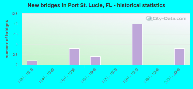
- New bridges - historical statistics
- 11930-1939
- 41950-1959
- 21960-1969
- 101980-1989
- 42000-2009

- Reconstructed bridges - Historical Statistics
- 11970-1979
- 21980-1989
- 01990-1999
- 32000-2009


- Bridge Condition - Deck
- 33.3%Very good
- 60.0%Good
- 6.7%Satisfactory

- Bridge Condition - Superstructure
- 40.0%Very good
- 46.7%Good
- 13.3%Satisfactory

- Bridge Condition - Substructure
- 40.0%Very good
- 33.3%Good
- 26.7%Satisfactory

- Bridge Condition - Channel
- 7.1%Very good
- 50.0%Good
- 21.4%Satisfactory
- 21.4%Fair

- Bridge Condition - Culverts
- 50.0%Good
- 50.0%Satisfactory
Find on map >> Show street view
Structure Number: 890108, Location: SB I-95 / SR-714 (Lat: 27.161678, Lng: -80.390819), Route carried "on" structure: Interstate 95, Year Built: 1984, Status: Open, Structure Length: 6.89m (22.60ft), Average Daily Traffic: 22,500 (year 2020), Truck Traffic: 6%, Average Future Daily Traffic: 39,038 (year 2042), Design Load: HS 20+Mod, Features Intersected: S.R. 714
Minimum Vertical Clearance: 30+ m (98+ ft), Kilometerpoint: 34.797, Lanes on structure: 3, Lanes under structure: 4, Base Highway Network: Yes, Owner: State Highway Agency, Approaching Roadway Width: 17.1m (56.1ft), Skew: 1 degrees, Material/Design: Prestressed concrete, Design/Construction: Stringer/Multi-beam, Number Of Spans In Main Unit: 2, Length of Maximum Span: 34.4m (112.9ft), Curb-To-Curb Width: 17.1m (56.1ft), Out-to-Out Width: 17.9m (58.7ft)
Condition: Deck: Good, Superstructure: Good, Substructure: Very good, Operating Rating: 61.3 metric tons, Method Used To Determine Operating Rating: Load Factor (LF), Inventory Rating: 39.9 metric tons, Method Used To Determine Inventory Rating: Load Factor (LF), Structural Evaluation: Better than present minimum criteria, Deck Geometry: Equal to present minimum criteria, Underclear: Equal to present minimum criteria, Approach Roadway Alignment: Equal to present desirable criteria, Designated Inspection Frequency: Every 24 months, Inspection Date: Febuary 2021, Deck Structure Type: Concrete Cast-file-Place
Find on map >> Show street view
Structure Number: 890109, Location: NB I-95 / SR 714 (Lat: 27.161683, Lng: -80.389397), Route carried "on" structure: Interstate 95, Year Built: 1984, Status: Open, Structure Length: 6.89m (22.60ft), Average Daily Traffic: 22,500 (year 2020), Truck Traffic: 6%, Average Future Daily Traffic: 39,038 (year 2042), Design Load: HS 20+Mod, Features Intersected: S. R. 714
Minimum Vertical Clearance: 30+ m (98+ ft), Kilometerpoint: 34.783, Lanes on structure: 3, Lanes under structure: 4, Base Highway Network: Yes, Owner: State Highway Agency, Approaching Roadway Width: 17.1m (56.1ft), Skew: 1 degrees, Material/Design: Prestressed concrete, Design/Construction: Stringer/Multi-beam, Number Of Spans In Main Unit: 2, Length of Maximum Span: 34.4m (112.9ft), Curb-To-Curb Width: 17.1m (56.1ft), Out-to-Out Width: 17.9m (58.7ft)
Condition: Deck: Good, Superstructure: Good, Substructure: Very good, Operating Rating: 61.3 metric tons, Method Used To Determine Operating Rating: Load Factor (LF), Inventory Rating: 39.9 metric tons, Method Used To Determine Inventory Rating: Load Factor (LF), Structural Evaluation: Better than present minimum criteria, Deck Geometry: Equal to present minimum criteria, Underclear: Equal to present minimum criteria, Approach Roadway Alignment: Equal to present desirable criteria, Designated Inspection Frequency: Every 24 months, Inspection Date: Febuary 2021, Deck Structure Type: Concrete Cast-file-Place
Find on map >> Show street view
Structure Number: 89011, Location: 2mi. N of SR714 on I95 (Lat: 27.206281, Lng: -80.400808), Route carried "on" structure: Interstate 95, Year Built: 1984, Year Reconstructed: 2009, Status: Open, Structure Length: 9.26m (30.38ft), Average Daily Traffic: 32,638 (year 2020), Truck Traffic: 13%, Average Future Daily Traffic: 56,626 (year 2042), Design Load: HL 93, Features Intersected: C-23 CANAL
Minimum Vertical Clearance: 30+ m (98+ ft), Kilometerpoint: 39.846, Lanes on structure: 4, Base Highway Network: Yes, Owner: State Highway Agency, Approaching Roadway Width: 16.6m (54.5ft), Material/Design: Prestressed concrete, Design/Construction: Stringer/Multi-beam, Number Of Spans In Main Unit: 5, Length of Maximum Span: 18.5m (60.7ft), Curb-To-Curb Width: 20.7m (67.9ft), Out-to-Out Width: 21.6m (70.9ft)
Condition: Deck: Good, Superstructure: Very good, Substructure: Good, Channel: Good, Operating Rating: 39.8 metric tons, Method Used To Determine Operating Rating: Load and Resistance Factor (LRFR), Inventory Rating: 36.9 metric tons, Method Used To Determine Inventory Rating: Load and Resistance Factor (LRFR), Structural Evaluation: Better than present minimum criteria, Deck Geometry: Equal to present minimum criteria, Waterway Adequacy: Superior to present desirable criteria, Approach Roadway Alignment: Equal to present desirable criteria, Designated Inspection Frequency: Every 24 months, Underwater Inspection Frequency: Every 24 months, Inspection Date: November 2020, Underwater Inspection Date: November 2020, Deck Structure Type: Concrete Cast-file-Place
Find on map >> Show street view
Structure Number: 890111, Location: 2mi.N of SR714 on I95 (Lat: 27.205425, Lng: -80.400253), Route carried "on" structure: Interstate 95, Year Built: 1984, Year Reconstructed: 2009, Status: Open, Structure Length: 9.26m (30.38ft), Average Daily Traffic: 32,638 (year 2020), Truck Traffic: 13%, Average Future Daily Traffic: 56,626 (year 2042), Design Load: HL 93, Features Intersected: C-23 Canal
Minimum Vertical Clearance: 30+ m (98+ ft), Kilometerpoint: 39.846, Lanes on structure: 4, Base Highway Network: Yes, Owner: State Highway Agency, Approaching Roadway Width: 16.6m (54.5ft), Material/Design: Prestressed concrete, Design/Construction: Stringer/Multi-beam, Number Of Spans In Main Unit: 5, Length of Maximum Span: 18.5m (60.7ft), Curb-To-Curb Width: 20.7m (67.9ft), Out-to-Out Width: 21.6m (70.9ft)
Condition: Deck: Very good, Superstructure: Good, Substructure: Good, Channel: Good, Operating Rating: 40.2 metric tons, Method Used To Determine Operating Rating: Load and Resistance Factor (LRFR), Inventory Rating: 36.9 metric tons, Method Used To Determine Inventory Rating: Load and Resistance Factor (LRFR), Structural Evaluation: Better than present minimum criteria, Deck Geometry: Equal to present minimum criteria, Waterway Adequacy: Superior to present desirable criteria, Approach Roadway Alignment: Equal to present desirable criteria, Designated Inspection Frequency: Every 24 months, Underwater Inspection Frequency: Every 24 months, Inspection Date: November 2020, Underwater Inspection Date: November 2020, Deck Structure Type: Concrete Cast-file-Place
Find on map >> Show street view
Structure Number: 89406, Location: 0.2MILE S OF SW BECKER RD (Lat: 27.205556, Lng: -80.371944), Route carried "on" structure: County highway , Year Built: 2008, Status: Open, Structure Length: 7.09m (23.26ft), Average Daily Traffic: 2,000 (year 2022), Truck Traffic: 2%, Average Future Daily Traffic: 5,000 (year 2042), Design Load: HL 93, Features Intersected: C-23 CANAL, Facility Carried by Structure: CITRUS BLVD.
Minimum Vertical Clearance: 30+ m (98+ ft), Kilometerpoint: 8.737, Lanes on structure: 2, Owner: County Highway Agency, Approaching Roadway Width: 11.3m (37.1ft), Material/Design: Prestressed concrete, Design/Construction: Stringer/Multi-beam, Number Of Spans In Main Unit: 5, Length of Maximum Span: 15.3m (50.2ft), Curb or Sidewalk Widths: Left: 0.0m, Right: 1.9m (6.2ft), Curb-To-Curb Width: 11.3m (37.1ft), Out-to-Out Width: 14.3m (46.9ft)
Condition: Deck: Very good, Superstructure: Very good, Substructure: Very good, Channel: Very good, Operating Rating: 46.1 metric tons, Method Used To Determine Operating Rating: Load and Resistance Factor (LRFR), Inventory Rating: 35.3 metric tons, Method Used To Determine Inventory Rating: Load and Resistance Factor (LRFR), Structural Evaluation: Equal to present desirable criteria, Deck Geometry: Equal to present minimum criteria, Waterway Adequacy: Equal to present desirable criteria, Approach Roadway Alignment: Better than present minimum criteria, Designated Inspection Frequency: Every 24 months, Underwater Inspection Frequency: Every 24 months, Inspection Date: January 2022, Underwater Inspection Date: January 2022, Deck Structure Type: Concrete Cast-file-Place
Find on map >> Show street view
Structure Number: 940001, Location: .3 m N of Martin Co. line (Lat: 27.267919, Lng: -80.286758), Route carried "on" structure: US 1, Year Built: 1936, Year Reconstructed: 1987, Status: Open, Structure Length: 2.75m (9.02ft), Average Daily Traffic: 29,250 (year 2020), Truck Traffic: 11%, Average Future Daily Traffic: 50,749 (year 2042), Design Load: H 15, Features Intersected: Howard Creek
Minimum Vertical Clearance: 30+ m (98+ ft), Kilometerpoint: 0.544, Lanes on structure: 4, Base Highway Network: Yes, Owner: State Highway Agency, Approaching Roadway Width: 20.5m (67.3ft), Skew: 2 degrees, Material/Design: Concrete, Design/Construction: Culvert, Number Of Spans In Main Unit: 3, Length of Maximum Span: 6.7m (22.0ft)
Condition: Channel: Good, Culverts: Good, Operating Rating: 53.8 metric tons, Method Used To Determine Operating Rating: Load Testing, Inventory Rating: 32.6 metric tons, Method Used To Determine Inventory Rating: Load Testing, Structural Evaluation: Better than present minimum criteria, Waterway Adequacy: Somewhat better than minimum adequacy, Approach Roadway Alignment: Equal to present desirable criteria, Designated Inspection Frequency: Every 24 months, Underwater Inspection Frequency: Every 24 months, Inspection Date: August 2020, Underwater Inspection Date: August 2020
Find on map >> Show street view
Structure Number: 940026, Location: AT MARTIN COUNTY LINE (Lat: 27.206289, Lng: -80.481406), Route carried "on" structure: County highway 609, Year Built: 1963, Year Reconstructed: 1987, Status: Open, Structure Length: 5.40m (17.72ft), Average Daily Traffic: 2,300 (year 2021), Truck Traffic: 10%, Average Future Daily Traffic: 3,991 (year 2042), Design Load: HS 20, Features Intersected: COUNTY LINE CANAL C-23
Minimum Vertical Clearance: 30+ m (98+ ft), Kilometerpoint: 0.000, Lanes on structure: 2, Owner: County Highway Agency, Approaching Roadway Width: 6.9m (22.6ft), Material/Design: Prestressed concrete, Design/Construction: Slab, Number Of Spans In Main Unit: 7, Length of Maximum Span: 7.6m (24.9ft), Curb-To-Curb Width: 12.1m (39.7ft), Out-to-Out Width: 13.0m (42.7ft)
Condition: Deck: Good, Superstructure: Good, Substructure: Satisfactory, Channel: Satisfactory, Operating Rating: 86.5 metric tons, Method Used To Determine Operating Rating: Load Factor (LF), Inventory Rating: 56.8 metric tons, Method Used To Determine Inventory Rating: Load Factor (LF), Structural Evaluation: Equal to present minimum criteria, Deck Geometry: Somewhat better than minimum adequacy, Waterway Adequacy: Better than present minimum criteria, Approach Roadway Alignment: Equal to present desirable criteria, Designated Inspection Frequency: Every 24 months, Underwater Inspection Frequency: Every 24 months, Inspection Date: January 2021, Underwater Inspection Date: January 2021, Deck Structure Type: Concrete Precast Panels, Wearing Surface/Protective System: Wearing Surface: Bituminous
Find on map >> Show street view
Structure Number: 940027, Location: 1.1 MILES NORTH OF SR-70 (Lat: 27.396331, Lng: -80.472711), Route carried "on" structure: County highway 609A, Year Built: 1956, Status: Posted for load, Structure Length: 2.74m (8.99ft), Average Daily Traffic: 2,000 (year 2022), Truck Traffic: 10%, Average Future Daily Traffic: 18,000 (year 2042), Features Intersected: TEN MILE CREEK
Minimum Vertical Clearance: 30+ m (98+ ft), Kilometerpoint: 6.497, Lanes on structure: 2, Owner: County Highway Agency, Approaching Roadway Width: 6.0m (19.7ft), Material/Design: Concrete, Design/Construction: Slab, Number Of Spans In Main Unit: 6, Length of Maximum Span: 4.6m (15.1ft), Curb-To-Curb Width: 7.3m (24.0ft), Out-to-Out Width: 8.8m (28.9ft)
Condition: Deck: Good, Superstructure: Good, Substructure: Satisfactory, Channel: Satisfactory, Operating Rating: 28.0 metric tons, Method Used To Determine Operating Rating: Load Factor (LF), Inventory Rating: 16.8 metric tons, Method Used To Determine Inventory Rating: Load Factor (LF), Structural Evaluation: Meets minimum limits, Deck Geometry: Meets minimum limits, Waterway Adequacy: Better than present minimum criteria, Approach Roadway Alignment: Equal to present desirable criteria, Bridge Posting: Required (Relationship of Operating Rating to Maximum Legal Load: 10.0 - 19.9% below), Designated Inspection Frequency: Every 24 months, Underwater Inspection Frequency: Every 24 months, Other Special Inspection Frequency: Every 12 months, Inspection Date: January 2021, Underwater Inspection Date: January 2021, Other Special Inspection Date: January 2022, Deck Structure Type: Concrete Precast Panels
Find on map >> Show street view
Structure Number: 94003, Location: 0.3MI N OF CR-712 (Lat: 27.379750, Lng: -80.448281), Route carried "on" structure: County highway 712A, Year Built: 1952, Status: Posted for load-capacity, Structure Length: 4.11m (13.48ft), Average Daily Traffic: 300 (year 2021), Truck Traffic: 5%, Average Future Daily Traffic: 500 (year 2042), Design Load: H 10, Features Intersected: TEN MILE CREEK
Minimum Vertical Clearance: 30+ m (98+ ft), Kilometerpoint: 0.575, Lanes on structure: 2, Owner: County Highway Agency, Approaching Roadway Width: 3.1m (10.2ft), Material/Design: Concrete, Design/Construction: Slab, Number Of Spans In Main Unit: 9, Length of Maximum Span: 4.6m (15.1ft), Curb or Sidewalk Widths: Left: 0.1m (0.3ft), Right: 0.1m (0.3ft), Curb-To-Curb Width: 7.3m (24.0ft), Out-to-Out Width: 7.8m (25.6ft)
Condition: Deck: Satisfactory, Superstructure: Satisfactory, Substructure: Satisfactory, Channel: Fair, Operating Rating: 40.2 metric tons, Method Used To Determine Operating Rating: Load Factor (LF), Inventory Rating: 24.1 metric tons, Method Used To Determine Inventory Rating: Load Factor (LF), Structural Evaluation: Equal to present minimum criteria, Deck Geometry: Somewhat better than minimum adequacy, Waterway Adequacy: Equal to present minimum criteria, Approach Roadway Alignment: Equal to present desirable criteria, Designated Inspection Frequency: Every 24 months, Inspection Date: January 2021, Deck Structure Type: Concrete Precast Panels
Find on map >> Show street view
Structure Number: 940038, Location: 0.8 MI S OF SR-70 (Lat: 27.389628, Lng: -80.440083), Route carried "on" structure: County highway 712B, Year Built: 1956, Status: Posted for load-capacity, Structure Length: 4.88m (16.01ft), Average Daily Traffic: 300 (year 2021), Truck Traffic: 5%, Average Future Daily Traffic: 500 (year 2042), Features Intersected: TEN MILE CREEK, Facility Carried by Structure: ELEVEN MILE ROAD
Minimum Vertical Clearance: 30+ m (98+ ft), Kilometerpoint: 0.000, Lanes on structure: 2, Owner: County Highway Agency, Approaching Roadway Width: 3.4m (11.2ft), Skew: 3 degrees, Material/Design: Concrete, Design/Construction: Slab, Number Of Spans In Main Unit: 8, Length of Maximum Span: 6.1m (20.0ft), Curb or Sidewalk Widths: Left: 0.5m (1.6ft), Right: 0.5m (1.6ft), Curb-To-Curb Width: 7.3m (24.0ft), Out-to-Out Width: 8.9m (29.2ft)
Condition: Deck: Good, Superstructure: Good, Substructure: Satisfactory, Channel: Satisfactory, Operating Rating: 45.8 metric tons, Method Used To Determine Operating Rating: Load Factor (LF), Inventory Rating: 27.5 metric tons, Method Used To Determine Inventory Rating: Load Factor (LF), Structural Evaluation: Equal to present minimum criteria, Deck Geometry: Somewhat better than minimum adequacy, Waterway Adequacy: Better than present minimum criteria, Approach Roadway Alignment: Equal to present desirable criteria, Designated Inspection Frequency: Every 24 months, Underwater Inspection Frequency: Every 24 months, Inspection Date: January 2021, Underwater Inspection Date: January 2021, Deck Structure Type: Concrete Cast-file-Place
Find on map >> Show street view
Structure Number: 940069, Location: 5.2MI S of CR-712 (Lat: 27.320333, Lng: -80.453375), Route carried "on" structure: County highway 709, Year Built: 1960, Status: Open, Structure Length: 4.85m (15.91ft), Average Daily Traffic: 3,600 (year 2021), Truck Traffic: 20%, Average Future Daily Traffic: 4,400 (year 2042), Design Load: H 20, Features Intersected: CANAL C-24, Facility Carried by Structure: GLADES CUTOFF
Minimum Vertical Clearance: 30+ m (98+ ft), Kilometerpoint: 3.919, Lanes on structure: 2, Owner: County Highway Agency, Approaching Roadway Width: 7.0m (23.0ft), Material/Design: Prestressed concrete, Design/Construction: Stringer/Multi-beam, Number Of Spans In Main Unit: 3, Length of Maximum Span: 16.2m (53.1ft), Curb-To-Curb Width: 7.3m (24.0ft), Out-to-Out Width: 7.8m (25.6ft)
Condition: Deck: Good, Superstructure: Good, Substructure: Good, Channel: Good, Operating Rating: 54.6 metric tons, Method Used To Determine Operating Rating: Allowable Stress (AS), Inventory Rating: 27.0 metric tons, Method Used To Determine Inventory Rating: Allowable Stress (AS), Structural Evaluation: Equal to present minimum criteria, Deck Geometry: High priority of replacement, Waterway Adequacy: Better than present minimum criteria, Approach Roadway Alignment: Equal to present desirable criteria, Designated Inspection Frequency: Every 24 months, Underwater Inspection Frequency: Every 24 months, Inspection Date: January 2021, Underwater Inspection Date: January 2021, Deck Structure Type: Concrete Cast-file-Place
Find on map >> Show street view
Structure Number: 940079, Location: .3m N of Martin Co. line (Lat: 27.268050, Lng: -80.286342), Route carried "on" structure: US 1, Year Built: 1956, Year Reconstructed: 1978, Status: Open, Structure Length: 0.85m (2.79ft), Average Daily Traffic: 29,250 (year 2020), Truck Traffic: 11%, Average Future Daily Traffic: 50,749 (year 2042), Design Load: H 15, Features Intersected: Howard Creek
Minimum Vertical Clearance: 30+ m (98+ ft), Kilometerpoint: 0.544, Lanes on structure: 4, Base Highway Network: Yes, Owner: State Highway Agency, Approaching Roadway Width: 16.2m (53.1ft), Skew: 2 degrees, Material/Design: Concrete, Design/Construction: Culvert, Number Of Spans In Main Unit: 3, Length of Maximum Span: 2.6m (8.5ft), Curb or Sidewalk Widths: Left: 0.0m, Right: 2.1m (6.9ft)
Condition: Channel: Good, Culverts: Satisfactory, Operating Rating: 42.6 metric tons, Method Used To Determine Operating Rating: Load Factor (LF), Inventory Rating: 25.4 metric tons, Method Used To Determine Inventory Rating: Load Factor (LF), Structural Evaluation: Equal to present minimum criteria, Waterway Adequacy: Somewhat better than minimum adequacy, Approach Roadway Alignment: Equal to present desirable criteria, Designated Inspection Frequency: Every 24 months, Underwater Inspection Frequency: Every 24 months, Inspection Date: August 2020, Underwater Inspection Date: August 2020
Find on map >> Show street view
Structure Number: 940119, Location: 7.0 mi. W of FL Turnpike (Lat: 27.373375, Lng: -80.497458), Route carried "on" structure: State highway 70, Year Built: 1986, Year Reconstructed: 2009, Status: Open, Structure Length: 3.63m (11.91ft), Average Daily Traffic: 3,750 (year 2020), Truck Traffic: 14%, Average Future Daily Traffic: 6,506 (year 2042), Design Load: HS 20, Features Intersected: Header Canal
Minimum Vertical Clearance: 30+ m (98+ ft), Kilometerpoint: 21.858, Lanes on structure: 3, Base Highway Network: Yes, Owner: State Highway Agency, Approaching Roadway Width: 11.6m (38.1ft), Skew: 2 degrees, Material/Design: Prestressed concrete, Design/Construction: Stringer/Multi-beam, Number Of Spans In Main Unit: 3, Length of Maximum Span: 12.1m (39.7ft), Curb-To-Curb Width: 20.7m (67.9ft), Out-to-Out Width: 21.6m (70.9ft)
Condition: Deck: Good, Superstructure: Very good, Substructure: Very good, Channel: Fair, Operating Rating: 57.2 metric tons, Method Used To Determine Operating Rating: Load and Resistance Factor (LRFR), Inventory Rating: 44.5 metric tons, Method Used To Determine Inventory Rating: Load and Resistance Factor (LRFR), Structural Evaluation: Equal to present desirable criteria, Deck Geometry: Superior to present desirable criteria, Waterway Adequacy: Superior to present desirable criteria, Approach Roadway Alignment: Equal to present desirable criteria, Designated Inspection Frequency: Every 24 months, Underwater Inspection Frequency: Every 24 months, Inspection Date: August 2020, Underwater Inspection Date: August 2020, Deck Structure Type: Concrete Cast-file-Place
Find on map >> Show street view
Structure Number: 94012, Location: 3.9 mi. W of FL Turnpike (Lat: 27.394358, Lng: -80.458519), Route carried "on" structure: State highway 70, Year Built: 1984, Status: Open, Structure Length: 4.11m (13.48ft), Average Daily Traffic: 2,792 (year 2020), Truck Traffic: 20%, Average Future Daily Traffic: 4,844 (year 2042), Design Load: HS 20, Features Intersected: Ten Mile Creek
Minimum Vertical Clearance: 30+ m (98+ ft), Kilometerpoint: 26.553, Lanes on structure: 2, Base Highway Network: Yes, Owner: State Highway Agency, Approaching Roadway Width: 9.8m (32.2ft), Skew: 2 degrees, Material/Design: Prestressed concrete, Design/Construction: Stringer/Multi-beam, Number Of Spans In Main Unit: 3, Length of Maximum Span: 13.7m (44.9ft), Curb-To-Curb Width: 13.4m (44.0ft), Out-to-Out Width: 14.3m (46.9ft)
Condition: Deck: Very good, Superstructure: Very good, Substructure: Good, Channel: Good, Operating Rating: 58.4 metric tons, Method Used To Determine Operating Rating: Load Factor (LF), Inventory Rating: 35.0 metric tons, Method Used To Determine Inventory Rating: Load Factor (LF), Structural Evaluation: Better than present minimum criteria, Deck Geometry: Superior to present desirable criteria, Waterway Adequacy: Superior to present desirable criteria, Approach Roadway Alignment: Equal to present desirable criteria, Designated Inspection Frequency: Every 24 months, Underwater Inspection Frequency: Every 24 months, Inspection Date: September 2020, Underwater Inspection Date: September 2020, Deck Structure Type: Concrete Cast-file-Place
Find on map >> Show street view
Structure Number: 940133, Location: 5.5MI. S of SR70 / I-95 (Lat: 27.311464, Lng: -80.414117), Route carried "on" structure: County highway , Year Built: 1989, Status: Open, Structure Length: 12.19m (39.99ft), Average Daily Traffic: 41,000 (year 2020), Truck Traffic: 10%, Average Future Daily Traffic: 71,135 (year 2042), Design Load: HS 20, Features Intersected: SR-9 (I-95), Facility Carried by Structure: St Lucie West Blvd
Minimum Vertical Clearance: 30+ m (98+ ft), Kilometerpoint: 0.380, Lanes on structure: 2, Lanes under structure: 7, Base Highway Network: Yes, Owner: State Highway Agency, Approaching Roadway Width: 11.6m (38.1ft), Material/Design: Prestressed concrete, Design/Construction: Stringer/Multi-beam, Number Of Spans In Main Unit: 3, Length of Maximum Span: 43.3m (142.1ft), Curb or Sidewalk Widths: Left: 2.5m (8.2ft), Right: 0.0m, Curb-To-Curb Width: 12.2m (40.0ft), Out-to-Out Width: 15.7m (51.5ft)
Condition: Deck: Good, Superstructure: Satisfactory, Substructure: Very good, Operating Rating: 86.7 metric tons, Method Used To Determine Operating Rating: Load Factor (LF), Inventory Rating: 52.0 metric tons, Method Used To Determine Inventory Rating: Load Factor (LF), Structural Evaluation: Equal to present minimum criteria, Deck Geometry: Somewhat better than minimum adequacy, Underclear: Equal to present minimum criteria, Approach Roadway Alignment: Equal to present desirable criteria, Designated Inspection Frequency: Every 24 months, Inspection Date: January 2021, Deck Structure Type: Concrete Cast-file-Place
Find on map >> Show street view
Structure Number: 940154, Location: 7 MI W of FL TPK SR91 (Lat: 27.373153, Lng: -80.497458), Route carried "on" structure: State highway 70, Year Built: 2008, Status: Open, Structure Length: 3.63m (11.91ft), Average Daily Traffic: 3,750 (year 2020), Truck Traffic: 14%, Average Future Daily Traffic: 6,506 (year 2042), Design Load: HL 93, Features Intersected: Header Creek Canal
Minimum Vertical Clearance: 30+ m (98+ ft), Kilometerpoint: 21.858, Lanes on structure: 2, Base Highway Network: Yes, Owner: State Highway Agency, Approaching Roadway Width: 11.6m (38.1ft), Skew: 2 degrees, Material/Design: Prestressed concrete, Design/Construction: Stringer/Multi-beam, Number Of Spans In Main Unit: 3, Length of Maximum Span: 12.1m (39.7ft), Curb-To-Curb Width: 12.6m (41.3ft), Out-to-Out Width: 13.1m (43.0ft)
Condition: Deck: Very good, Superstructure: Very good, Substructure: Very good, Channel: Fair, Operating Rating: 50.8 metric tons, Method Used To Determine Operating Rating: Load and Resistance Factor (LRFR), Inventory Rating: 39.0 metric tons, Method Used To Determine Inventory Rating: Load and Resistance Factor (LRFR), Structural Evaluation: Equal to present desirable criteria, Deck Geometry: Better than present minimum criteria, Waterway Adequacy: Superior to present desirable criteria, Approach Roadway Alignment: Equal to present desirable criteria, Designated Inspection Frequency: Every 24 months, Underwater Inspection Frequency: Every 24 months, Inspection Date: August 2020, Underwater Inspection Date: August 2020, Deck Structure Type: Concrete Cast-file-Place
Find on map >> Show street view
Structure Number: 940156, Location: 3.9 MI W of FL Tpk SR 91 (Lat: 27.394322, Lng: -80.458228), Route carried "on" structure: State highway 70, Year Built: 2008, Status: Open, Structure Length: 4.11m (13.48ft), Average Daily Traffic: 2,792 (year 2020), Truck Traffic: 20%, Average Future Daily Traffic: 4,844 (year 2042), Design Load: HL 93, Features Intersected: Ten Mile Creek
Minimum Vertical Clearance: 30+ m (98+ ft), Kilometerpoint: 26.599, Lanes on structure: 2, Base Highway Network: Yes, Owner: State Highway Agency, Approaching Roadway Width: 11.6m (38.1ft), Skew: 2 degrees, Material/Design: Prestressed concrete, Design/Construction: Stringer/Multi-beam, Number Of Spans In Main Unit: 3, Length of Maximum Span: 13.7m (44.9ft), Curb-To-Curb Width: 12.2m (40.0ft), Out-to-Out Width: 13.1m (43.0ft)
Condition: Deck: Very good, Superstructure: Very good, Substructure: Good, Channel: Good, Operating Rating: 40.8 metric tons, Method Used To Determine Operating Rating: Load and Resistance Factor (LRFR), Inventory Rating: 32.7 metric tons, Method Used To Determine Inventory Rating: Load and Resistance Factor (LRFR), Structural Evaluation: Better than present minimum criteria, Deck Geometry: Better than present minimum criteria, Waterway Adequacy: Superior to present desirable criteria, Approach Roadway Alignment: Equal to present desirable criteria, Designated Inspection Frequency: Every 24 months, Underwater Inspection Frequency: Every 24 months, Inspection Date: September 2020, Underwater Inspection Date: September 2020, Deck Structure Type: Concrete Cast-file-Place
Find on map >> Show street view
Structure Number: 890108, Location: SB I-95 / SR-714 (Lat: 27.161678, Lng: -80.390819), Route carried "under" structure: State highway 714, Year Built: 1984, Structure Length: 0. m, Average Daily Traffic: 6,200 (year 2020), Truck Traffic: 20%, Features Intersected: S.R. 714, Facility Carried by Structure: SB I-95 (SR 9)
Minimum Vertical Clearance: 4.97m (16.31ft), Kilometerpoint: 8.991, Lanes on structure: 3, Lanes under structure: 4, Material/Design: Prestressed concrete, Design/Construction: Stringer/Multi-beam, Length of Maximum Span: 34.4m (112.9ft)
Find on map >> Show street view
Structure Number: 890109, Location: NB I-95 / SR 714 (Lat: 27.161683, Lng: -80.389397), Route carried "under" structure: State highway 714, Year Built: 1984, Structure Length: 0. m, Average Daily Traffic: 14,300 (year 2020), Truck Traffic: 15%, Features Intersected: S. R. 714, Facility Carried by Structure: NB I-95 (SR-9)
Minimum Vertical Clearance: 4.97m (16.31ft), Kilometerpoint: 9.128, Lanes on structure: 3, Lanes under structure: 4, Material/Design: Prestressed concrete, Design/Construction: Stringer/Multi-beam, Length of Maximum Span: 34.4m (112.9ft)
Find on map >> Show street view
Structure Number: 940133, Location: 5.5MI. S of SR70 / I-95 (Lat: 27.311464, Lng: -80.414117), Route carried "under" structure: Interstate 95, Year Built: 1989, Structure Length: 0. m, Average Daily Traffic: 80,500 (year 2020), Truck Traffic: 12%, Features Intersected: SR-9 (I-95), Facility Carried by Structure: St Lucie West Blvd
Minimum Vertical Clearance: 5.19m (17.03ft), Kilometerpoint: 12.489, Lanes on structure: 2, Lanes under structure: 7, Material/Design: Prestressed concrete, Design/Construction: Stringer/Multi-beam, Length of Maximum Span: 43.3m (142.1ft)
Find on map >> Show street view
Structure Number: 949001, Location: 0.25mi. west of C.R. 712 (Lat: 27.375944, Lng: -80.487111), Route carried "under" structure: State highway 70, Year Built: 2009, Structure Length: 0. m, Average Daily Traffic: 4,000 (year 2018), Truck Traffic: 10%, Features Intersected: S. R. 70, Facility Carried by Structure: PedestrianOverpass
Minimum Vertical Clearance: 6.59m (21.62ft), Kilometerpoint: 22.949, Lanes under structure: 7, Material/Design: Prestressed concrete, Design/Construction: Stringer/Multi-beam, Length of Maximum Span: 35.7m (117.1ft)