Bridge Statistics for Pinellas Park, Florida (FL)
Condition, Traffic, Stress, Structural Evaluation, Project Costs
- National Bridge Inventory (NBI) Statistics
- 51Number of bridges
- 679ft / 207mTotal length
- 1,156,818Total average daily traffic
- 55,828Total average daily truck traffic
- National Bridge Inventory (NBI) Registered Bridges for Pinellas Park
- No street view available for this location
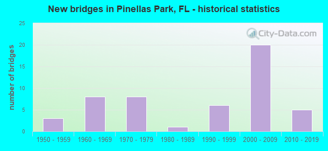
- New bridges - historical statistics
- 31950-1959
- 81960-1969
- 81970-1979
- 11980-1989
- 61990-1999
- 202000-2009
- 52010-2019
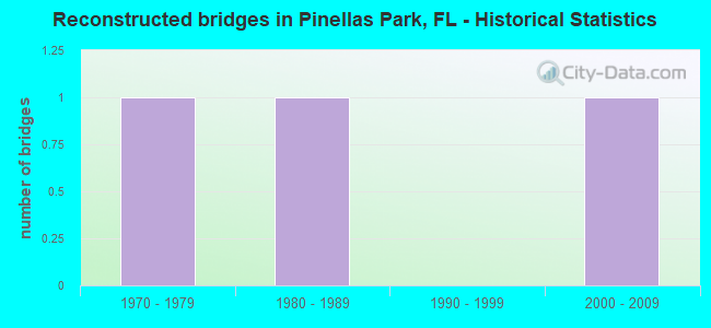
- Reconstructed bridges - Historical Statistics
- 11970-1979
- 11980-1989
- 01990-1999
- 12000-2009
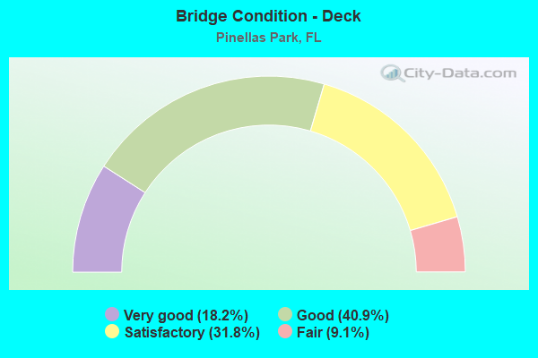
- Bridge Condition - Deck
- 18.2%Very good
- 40.9%Good
- 31.8%Satisfactory
- 9.1%Fair
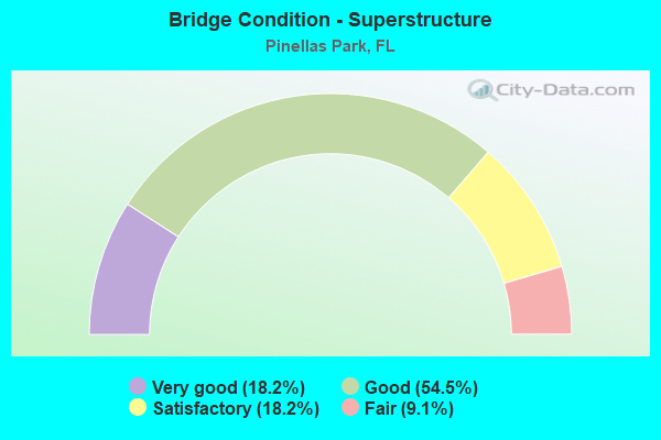
- Bridge Condition - Superstructure
- 18.2%Very good
- 54.5%Good
- 18.2%Satisfactory
- 9.1%Fair
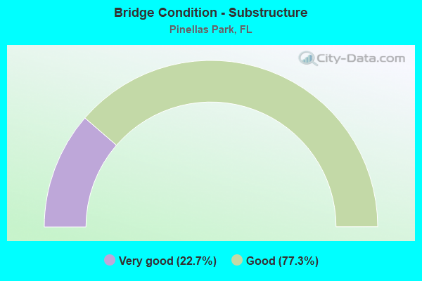
- Bridge Condition - Substructure
- 22.7%Very good
- 77.3%Good
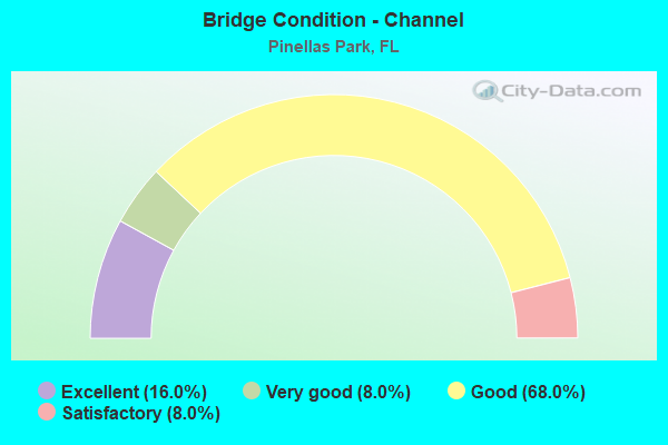
- Bridge Condition - Channel
- 16.0%Excellent
- 8.0%Very good
- 68.0%Good
- 8.0%Satisfactory
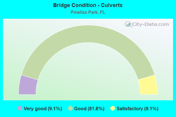
- Bridge Condition - Culverts
- 9.1%Very good
- 81.8%Good
- 9.1%Satisfactory
Find on map >> Show street view
Structure Number: 150017, Location: 0.8MI. S OF PARK BLVD. (Lat: 27.827444, Lng: -82.728481), Route carried "on" structure: State highway 693, Year Built: 1966, Status: Open, Structure Length: 1.29m (4.23ft), Average Daily Traffic: 39,500 (year 2020), Truck Traffic: 4%, Average Future Daily Traffic: 68,532 (year 2042), Design Load: HS 20+Mod, Features Intersected: KENNETH CITY SLOUGH
Minimum Vertical Clearance: 30+ m (98+ ft), Kilometerpoint: 7.376, Lanes on structure: 6, Base Highway Network: Yes, Owner: State Highway Agency, Approaching Roadway Width: 21.9m (71.9ft), Skew: 4 degrees, Material/Design: Concrete, Design/Construction: Culvert, Number Of Spans In Main Unit: 3, Length of Maximum Span: 4.0m (13.1ft)
Condition: Channel: Good, Culverts: Good, Operating Rating: 68.6 metric tons, Method Used To Determine Operating Rating: Load Factor (LF), Inventory Rating: 41.1 metric tons, Method Used To Determine Inventory Rating: Load Factor (LF), Structural Evaluation: Better than present minimum criteria, Waterway Adequacy: Better than present minimum criteria, Approach Roadway Alignment: Equal to present desirable criteria, Designated Inspection Frequency: Every 24 months, Inspection Date: November 2021
Find on map >> Show street view
Structure Number: 150055, Location: 2MI N OF SR-694 (Lat: 27.862400, Lng: -82.700242), Route carried "on" structure: US 19, Year Built: 1970, Year Reconstructed: 1987, Status: Open, Structure Length: 9.57m (31.40ft), Average Daily Traffic: 62,000 (year 2020), Truck Traffic: 6%, Average Future Daily Traffic: 107,570 (year 2042), Design Load: HS 20, Features Intersected: CR-611 (49TH ST)
Minimum Vertical Clearance: 30.45m (99.90ft), Kilometerpoint: 17.820, Lanes on structure: 6, Lanes under structure: 4, Base Highway Network: Yes, Owner: State Highway Agency, Approaching Roadway Width: 35.8m (117.5ft), Skew: 35 degrees, Material/Design: Prestressed concrete, Design/Construction: Stringer/Multi-beam, Number Of Spans In Main Unit: 4, Length of Maximum Span: 29.0m (95.1ft), Curb-To-Curb Width: 35.4m (116.1ft), Out-to-Out Width: 37.4m (122.7ft)
Condition: Deck: Good, Superstructure: Good, Substructure: Good, Operating Rating: 61.7 metric tons, Method Used To Determine Operating Rating: Allowable Stress (AS), Inventory Rating: 53.5 metric tons, Method Used To Determine Inventory Rating: Allowable Stress (AS), Structural Evaluation: Better than present minimum criteria, Deck Geometry: Superior to present desirable criteria, Underclear: Equal to present minimum criteria, Approach Roadway Alignment: Equal to present desirable criteria, Designated Inspection Frequency: Every 24 months, Inspection Date: March 2020, Deck Structure Type: Concrete Cast-file-Place
Find on map >> Show street view
Structure Number: 150061, Location: 100FT N OF 44TH AVE NORTH (Lat: 27.813011, Lng: -82.679522), Route carried "on" structure: US 19, Year Built: 1952, Status: Open, Structure Length: 0.94m (3.08ft), Average Daily Traffic: 38,000 (year 2020), Truck Traffic: 4%, Average Future Daily Traffic: 65,930 (year 2042), Design Load: H 15, Features Intersected: JOES CREEK
Minimum Vertical Clearance: 30+ m (98+ ft), Kilometerpoint: 11.796, Lanes on structure: 6, Base Highway Network: Yes, Owner: State Highway Agency, Approaching Roadway Width: 21.3m (69.9ft), Skew: 24 degrees, Material/Design: Concrete, Design/Construction: Culvert, Number Of Spans In Main Unit: 2, Length of Maximum Span: 3.9m (12.8ft)
Condition: Channel: Good, Culverts: Good, Inventory Rating: 57.1 metric tons, Method Used To Determine Inventory Rating: Load Factor (LF), Structural Evaluation: Better than present minimum criteria, Waterway Adequacy: Equal to present desirable criteria, Approach Roadway Alignment: Equal to present desirable criteria, Designated Inspection Frequency: Every 24 months, Inspection Date: March 2020
Find on map >> Show street view
Structure Number: 150064, Location: 0.8 MI E OF STARKEY ROAD (Lat: 27.839108, Lng: -82.752053), Route carried "on" structure: County highway 694, Year Built: 1976, Status: Open, Structure Length: 4.57m (14.99ft), Average Daily Traffic: 49,500 (year 2020), Truck Traffic: 3%, Average Future Daily Traffic: 85,883 (year 2042), Design Load: HS 20, Features Intersected: CROSS BAYOU
Minimum Vertical Clearance: 30+ m (98+ ft), Kilometerpoint: 12.099, Lanes on structure: 6, Base Highway Network: Yes, Owner: County Highway Agency, Approaching Roadway Width: 22.0m (72.2ft), Skew: 21 degrees, Material/Design: Prestressed concrete, Design/Construction: Slab, Number Of Spans In Main Unit: 5, Length of Maximum Span: 9.1m (29.9ft), Curb or Sidewalk Widths: Left: 2.2m (7.2ft), Right: 2.2m (7.2ft), Curb-To-Curb Width: 22.0m (72.2ft), Out-to-Out Width: 33.5m (109.9ft)
Condition: Deck: Satisfactory, Superstructure: Satisfactory, Substructure: Good, Channel: Good, Operating Rating: 48.8 metric tons, Method Used To Determine Operating Rating: Load Factor (LF), Inventory Rating: 29.3 metric tons, Method Used To Determine Inventory Rating: Load Factor (LF), Structural Evaluation: Equal to present minimum criteria, Deck Geometry: High priority of corrective action, Waterway Adequacy: Equal to present desirable criteria, Approach Roadway Alignment: Equal to present desirable criteria, Designated Inspection Frequency: Every 24 months, Underwater Inspection Frequency: Every 24 months, Inspection Date: November 2021, Underwater Inspection Date: October 2021, Deck Structure Type: Concrete Precast Panels, Wearing Surface/Protective System: Wearing Surface: Bituminous
Find on map >> Show street view
Structure Number: 150071, Location: 0.6 MI. S OF PARK BLVD. (Lat: 27.834194, Lng: -82.754194), Route carried "on" structure: County highway 695, Year Built: 1966, Status: Open, Structure Length: 12.19m (39.99ft), Average Daily Traffic: 14,000 (year 2020), Truck Traffic: 3%, Average Future Daily Traffic: 24,290 (year 2042), Design Load: HS 20, Features Intersected: CROSS BAYOU CANAL, Facility Carried by Structure: PARK ST NORTH NB
Minimum Vertical Clearance: 30+ m (98+ ft), Kilometerpoint: 2.691, Lanes on structure: 2, Owner: County Highway Agency, Approaching Roadway Width: 7.9m (25.9ft), Skew: 4 degrees, Material/Design: Prestressed concrete, Design/Construction: Stringer/Multi-beam, Number Of Spans In Main Unit: 10, Length of Maximum Span: 12.2m (40.0ft), Curb or Sidewalk Widths: Left: 0.4m (1.3ft), Right: 0.4m (1.3ft), Curb-To-Curb Width: 9.2m (30.2ft), Out-to-Out Width: 10.7m (35.1ft)
Condition: Deck: Good, Superstructure: Good, Substructure: Good, Channel: Good, Operating Rating: 52.0 metric tons, Method Used To Determine Operating Rating: Load Factor (LF), Inventory Rating: 46.6 metric tons, Method Used To Determine Inventory Rating: Load Factor (LF), Structural Evaluation: Better than present minimum criteria, Deck Geometry: Meets minimum limits, Waterway Adequacy: Superior to present desirable criteria, Approach Roadway Alignment: Equal to present desirable criteria, Designated Inspection Frequency: Every 24 months, Underwater Inspection Frequency: Every 24 months, Inspection Date: November 2021, Underwater Inspection Date: October 2021, Deck Structure Type: Concrete Cast-file-Place
Find on map >> Show street view
Structure Number: 150125, Location: 1.25 MILES W OF I-275 (Lat: 27.839592, Lng: -82.684011), Route carried "on" structure: State highway 694, Year Built: 1977, Status: Open, Structure Length: 11.09m (36.38ft), Average Daily Traffic: 62,000 (year 2020), Truck Traffic: 6%, Average Future Daily Traffic: 107,570 (year 2042), Design Load: HS 20+Mod, Features Intersected: US-19 SR-55
Minimum Vertical Clearance: 30+ m (98+ ft), Kilometerpoint: 0.000, Lanes on structure: 4, Lanes under structure: 7, Base Highway Network: Yes, Owner: State Highway Agency, Approaching Roadway Width: 22.5m (73.8ft), Skew: 31 degrees, Material/Design: Steel continuous, Design/Construction: Stringer/Multi-beam, Number Of Spans In Main Unit: 3, Length of Maximum Span: 49.3m (161.7ft), Curb-To-Curb Width: 21.9m (71.9ft), Out-to-Out Width: 23.7m (77.8ft)
Condition: Deck: Satisfactory, Superstructure: Good, Substructure: Good, Operating Rating: 41.1 metric tons, Method Used To Determine Operating Rating: Load Factor (LF), Inventory Rating: 24.8 metric tons, Method Used To Determine Inventory Rating: Load Factor (LF), Structural Evaluation: Equal to present minimum criteria, Deck Geometry: Superior to present desirable criteria, Underclear: Better than present minimum criteria, Approach Roadway Alignment: Equal to present minimum criteria, Designated Inspection Frequency: Every 24 months, Inspection Date: April 2021, Deck Structure Type: Concrete Cast-file-Place
Find on map >> Show street view
Structure Number: 150139, Location: 0.6 MI. S OF PARK BLVD. (Lat: 27.834028, Lng: -82.754278), Route carried "on" structure: County highway 695, Year Built: 1976, Status: Open, Structure Length: 12.19m (39.99ft), Average Daily Traffic: 14,000 (year 2020), Truck Traffic: 3%, Average Future Daily Traffic: 24,290 (year 2042), Design Load: HS 20, Features Intersected: CROSS BAYOU CANAL, Facility Carried by Structure: PARK ST NORTH SB
Minimum Vertical Clearance: 30+ m (98+ ft), Kilometerpoint: 2.672, Lanes on structure: 2, Owner: County Highway Agency, Approaching Roadway Width: 10.1m (33.1ft), Skew: 9 degrees, Material/Design: Prestressed concrete, Design/Construction: Stringer/Multi-beam, Number Of Spans In Main Unit: 10, Length of Maximum Span: 12.3m (40.4ft), Curb-To-Curb Width: 10.1m (33.1ft), Out-to-Out Width: 11.0m (36.1ft)
Condition: Deck: Good, Superstructure: Good, Substructure: Good, Channel: Good, Operating Rating: 44.3 metric tons, Method Used To Determine Operating Rating: Load Factor (LF), Inventory Rating: 39.4 metric tons, Method Used To Determine Inventory Rating: Load Factor (LF), Structural Evaluation: Better than present minimum criteria, Deck Geometry: Somewhat better than minimum adequacy, Waterway Adequacy: Equal to present desirable criteria, Approach Roadway Alignment: Equal to present desirable criteria, Designated Inspection Frequency: Every 24 months, Underwater Inspection Frequency: Every 24 months, Inspection Date: November 2021, Underwater Inspection Date: October 2021, Deck Structure Type: Concrete Cast-file-Place
Find on map >> Show street view
Structure Number: 150177, Location: 0.6MI. N OF SR-694 (Lat: 27.848278, Lng: -82.728667), Route carried "on" structure: State highway 693, Year Built: 1980, Status: Open, Structure Length: 1.69m (5.54ft), Average Daily Traffic: 36,500 (year 2020), Truck Traffic: 5%, Average Future Daily Traffic: 63,328 (year 2042), Design Load: HS 20+Mod, Features Intersected: 84TH AVE FLOOD CANAL
Minimum Vertical Clearance: 30+ m (98+ ft), Kilometerpoint: 5.337, Lanes on structure: 7, Base Highway Network: Yes, Owner: State Highway Agency, Approaching Roadway Width: 26.1m (85.6ft), Material/Design: Prestressed concrete, Design/Construction: Slab, Number Of Spans In Main Unit: 2, Length of Maximum Span: 8.5m (27.9ft), Curb or Sidewalk Widths: Left: 1.6m (5.2ft), Right: 1.6m (5.2ft), Curb-To-Curb Width: 26.1m (85.6ft), Out-to-Out Width: 30.4m (99.7ft)
Condition: Deck: Good, Superstructure: Good, Substructure: Good, Channel: Good, Operating Rating: 65.3 metric tons, Method Used To Determine Operating Rating: Allowable Stress (AS), Inventory Rating: 50.8 metric tons, Method Used To Determine Inventory Rating: Allowable Stress (AS), Structural Evaluation: Better than present minimum criteria, Deck Geometry: Meets minimum limits, Waterway Adequacy: Equal to present desirable criteria, Approach Roadway Alignment: Equal to present desirable criteria, Designated Inspection Frequency: Every 24 months, Inspection Date: March 2020, Deck Structure Type: Concrete Precast Panels, Wearing Surface/Protective System: Wearing Surface: Bituminous
Find on map >> Show street view
Structure Number: 150217, Location: 0.5MI. E OF US-19 (Lat: 27.846106, Lng: -82.677203), Route carried "on" structure: State highway 694, Year Built: 1951, Year Reconstructed: 2009, Status: Open, Structure Length: 1.21m (3.97ft), Average Daily Traffic: 73,000 (year 2020), Truck Traffic: 6%, Average Future Daily Traffic: 126,655 (year 2042), Design Load: HS 20+Mod, Features Intersected: SAWGRASS CREEK, Facility Carried by Structure: GNDY BLVD&GRAND AV
Minimum Vertical Clearance: 30.45m (99.90ft), Kilometerpoint: 1.146, Lanes on structure: 15, Base Highway Network: Yes, Owner: State Highway Agency, Approaching Roadway Width: 42.3m (138.8ft), Skew: 24 degrees, Material/Design: Concrete, Design/Construction: Culvert, Number Of Spans In Main Unit: 4, Length of Maximum Span: 3.0m (9.8ft)
Condition: Channel: Good, Culverts: Good, Inventory Rating: 54.1 metric tons, Method Used To Determine Inventory Rating: Load Factor (LF), Structural Evaluation: Better than present minimum criteria, Waterway Adequacy: Equal to present desirable criteria, Approach Roadway Alignment: Equal to present desirable criteria, Designated Inspection Frequency: Every 24 months, Underwater Inspection Frequency: Every 23 months, Inspection Date: April 2021, Underwater Inspection Date: April 2021
Find on map >> Show street view
Structure Number: 150256, Location: 1.2 MI. SOUTH OF SR-688 (Lat: 27.879028, Lng: -82.712167), Route carried "on" structure: US 19, Year Built: 2009, Status: Open, Structure Length: 16.00m (52.49ft), Average Daily Traffic: 30,000 (year 2020), Truck Traffic: 4%, Average Future Daily Traffic: 52,050 (year 2042), Design Load: HS 20, Features Intersected: 118TH AVENUE
Minimum Vertical Clearance: 5.47m (17.95ft), Kilometerpoint: 19.961, Lanes on structure: 3, Lanes under structure: 10, Base Highway Network: Yes, Owner: State Highway Agency, Approaching Roadway Width: 15.5m (50.9ft), Material/Design: Steel continuous, Design/Construction: Box Beam or Girders - Single/Spread, Number Of Spans In Main Unit: 3, Length of Maximum Span: 70.0m (229.7ft), Curb-To-Curb Width: 15.5m (50.9ft), Out-to-Out Width: 16.5m (54.1ft)
Condition: Deck: Very good, Superstructure: Very good, Substructure: Very good, Operating Rating: 55.2 metric tons, Method Used To Determine Operating Rating: Load Factor (LF), Inventory Rating: 33.0 metric tons, Method Used To Determine Inventory Rating: Load Factor (LF), Structural Evaluation: Equal to present desirable criteria, Deck Geometry: Equal to present minimum criteria, Underclear: Better than present minimum criteria, Approach Roadway Alignment: Equal to present desirable criteria, Designated Inspection Frequency: Every 24 months, Critical Feature Inspection Frequency: Every 12 months, Inspection Date: September 2021, Critical Feature Inspection Date: September 2021, Deck Structure Type: Concrete Cast-file-Place
Find on map >> Show street view
Structure Number: 150257, Location: 1.2 MI SOUTH OF SR-688 (Lat: 27.879025, Lng: -82.711972), Route carried "on" structure: US 19, Year Built: 2008, Status: Open, Structure Length: 16.00m (52.49ft), Average Daily Traffic: 30,000 (year 2020), Truck Traffic: 4%, Average Future Daily Traffic: 52,050 (year 2042), Design Load: HS 20, Features Intersected: 118TH AVENUE
Minimum Vertical Clearance: 5.76m (18.90ft), Kilometerpoint: 19.787, Lanes on structure: 3, Lanes under structure: 10, Base Highway Network: Yes, Owner: State Highway Agency, Approaching Roadway Width: 15.5m (50.9ft), Material/Design: Steel continuous, Design/Construction: Box Beam or Girders - Single/Spread, Number Of Spans In Main Unit: 3, Length of Maximum Span: 70.0m (229.7ft), Curb-To-Curb Width: 15.5m (50.9ft), Out-to-Out Width: 16.5m (54.1ft)
Condition: Deck: Satisfactory, Superstructure: Very good, Substructure: Very good, Operating Rating: 55.2 metric tons, Method Used To Determine Operating Rating: Load Factor (LF), Inventory Rating: 33.0 metric tons, Method Used To Determine Inventory Rating: Load Factor (LF), Structural Evaluation: Equal to present desirable criteria, Deck Geometry: Equal to present minimum criteria, Underclear: Better than present minimum criteria, Approach Roadway Alignment: Equal to present desirable criteria, Designated Inspection Frequency: Every 24 months, Critical Feature Inspection Frequency: Every 12 months, Inspection Date: September 2021, Critical Feature Inspection Date: September 2021, Deck Structure Type: Concrete Cast-file-Place
Find on map >> Show street view
Structure Number: 150258, Location: 1.75 MI SOUTH OF SR-688 (Lat: 27.871925, Lng: -82.707133), Route carried "on" structure: US 19, Year Built: 2009, Status: Open, Structure Length: 15.99m (52.46ft), Average Daily Traffic: 30,000 (year 2020), Truck Traffic: 4%, Average Future Daily Traffic: 52,050 (year 2042), Design Load: HS 20, Features Intersected: 110TH AVENUE
Minimum Vertical Clearance: 30.45m (99.90ft), Kilometerpoint: 19.034, Lanes on structure: 3, Lanes under structure: 6, Base Highway Network: Yes, Owner: State Highway Agency, Approaching Roadway Width: 15.5m (50.9ft), Material/Design: Steel continuous, Design/Construction: Box Beam or Girders - Single/Spread, Number Of Spans In Main Unit: 3, Length of Maximum Span: 69.8m (229.0ft), Curb-To-Curb Width: 15.5m (50.9ft), Out-to-Out Width: 16.5m (54.1ft)
Condition: Deck: Very good, Superstructure: Very good, Substructure: Very good, Operating Rating: 55.2 metric tons, Method Used To Determine Operating Rating: Load Factor (LF), Inventory Rating: 33.0 metric tons, Method Used To Determine Inventory Rating: Load Factor (LF), Structural Evaluation: Equal to present desirable criteria, Deck Geometry: Somewhat better than minimum adequacy, Underclear: Better than present minimum criteria, Approach Roadway Alignment: Equal to present desirable criteria, Designated Inspection Frequency: Every 24 months, Critical Feature Inspection Frequency: Every 12 months, Inspection Date: September 2021, Critical Feature Inspection Date: September 2021, Deck Structure Type: Concrete Cast-file-Place
Find on map >> Show street view
Structure Number: 150259, Location: 1.75 MI. SOUTH OF SR-688 (Lat: 27.871919, Lng: -82.706914), Route carried "on" structure: US 19, Year Built: 2008, Status: Open, Structure Length: 15.99m (52.46ft), Average Daily Traffic: 30,000 (year 2020), Truck Traffic: 4%, Average Future Daily Traffic: 52,050 (year 2042), Design Load: HS 20, Features Intersected: 110TH AVENUE
Minimum Vertical Clearance: 30.45m (99.90ft), Kilometerpoint: 18.931, Lanes on structure: 3, Lanes under structure: 6, Base Highway Network: Yes, Owner: State Highway Agency, Approaching Roadway Width: 15.5m (50.9ft), Material/Design: Steel continuous, Design/Construction: Box Beam or Girders - Single/Spread, Number Of Spans In Main Unit: 3, Length of Maximum Span: 69.8m (229.0ft), Curb-To-Curb Width: 15.5m (50.9ft), Out-to-Out Width: 16.5m (54.1ft)
Condition: Deck: Very good, Superstructure: Very good, Substructure: Very good, Operating Rating: 55.2 metric tons, Method Used To Determine Operating Rating: Load Factor (LF), Inventory Rating: 33.0 metric tons, Method Used To Determine Inventory Rating: Load Factor (LF), Structural Evaluation: Equal to present desirable criteria, Deck Geometry: Somewhat better than minimum adequacy, Underclear: Better than present minimum criteria, Approach Roadway Alignment: Equal to present desirable criteria, Designated Inspection Frequency: Every 24 months, Critical Feature Inspection Frequency: Every 12 months, Inspection Date: September 2021, Critical Feature Inspection Date: September 2021, Deck Structure Type: Concrete Cast-file-Place
Find on map >> Show street view
Structure Number: 150265, Location: 0.8 MI. W OF I-275 (Lat: 27.878783, Lng: -82.678069), Route carried "on" structure: State highway 686, Year Built: 2010, Status: Open, Structure Length: 46.19m (151.54ft), Average Daily Traffic: 6,500 (year 2020), Truck Traffic: 3%, Average Future Daily Traffic: 11,278 (year 2042), Design Load: HL 93, Features Intersected: 34TH ST 118TH AV & RAMP
Minimum Vertical Clearance: 30+ m (98+ ft), Kilometerpoint: 3.092, Lanes on structure: 2, Lanes under structure: 6, Base Highway Network: Yes, Owner: State Highway Agency, Approaching Roadway Width: 12.6m (41.3ft), Skew: 3 degrees, Material/Design: Prestressed concrete, Design/Construction: Stringer/Multi-beam, Number Of Spans In Main Unit: 11, Length of Maximum Span: 54.6m (179.1ft), Curb-To-Curb Width: 12.6m (41.3ft), Out-to-Out Width: 13.6m (44.6ft)
Condition: Deck: Satisfactory, Superstructure: Good, Substructure: Good, Channel: Very good, Operating Rating: 37.2 metric tons, Method Used To Determine Operating Rating: Load and Resistance Factor (LRFR), Inventory Rating: 33.7 metric tons, Method Used To Determine Inventory Rating: Load and Resistance Factor (LRFR), Structural Evaluation: Better than present minimum criteria, Deck Geometry: Better than present minimum criteria, Underclear: Better than present minimum criteria, Waterway Adequacy: Superior to present desirable criteria, Approach Roadway Alignment: Equal to present desirable criteria, Designated Inspection Frequency: Every 24 months, Inspection Date: November 2020, Deck Structure Type: Concrete Cast-file-Place
Find on map >> Show street view
Structure Number: 150941, Location: 0.2MI. NORTH OF 38TH AV N (Lat: 27.809061, Lng: -82.679522), Route carried "on" structure: US 19, Year Built: 1952, Year Reconstructed: 1975, Status: Open, Structure Length: 6.55m (21.49ft), Average Daily Traffic: 38,000 (year 2020), Truck Traffic: 4%, Average Future Daily Traffic: 65,930 (year 2042), Design Load: H 20, Features Intersected: CSX RR
Minimum Vertical Clearance: 30+ m (98+ ft), Kilometerpoint: 11.336, Lanes on structure: 6, Base Highway Network: Yes, Owner: State Highway Agency, Approaching Roadway Width: 23.5m (77.1ft), Skew: 34 degrees, Material/Design: Steel, Design/Construction: Stringer/Multi-beam, Number Of Spans In Main Unit: 5, Length of Maximum Span: 16.8m (55.1ft), Curb or Sidewalk Widths: Left: 1.8m (5.9ft), Right: 1.8m (5.9ft), Curb-To-Curb Width: 23.5m (77.1ft), Out-to-Out Width: 24.9m (81.7ft)
Condition: Deck: Good, Superstructure: Good, Substructure: Good, Operating Rating: 48.1 metric tons, Method Used To Determine Operating Rating: Load Factor (LF), Inventory Rating: 29.0 metric tons, Method Used To Determine Inventory Rating: Load Factor (LF), Structural Evaluation: Better than present minimum criteria, Deck Geometry: Somewhat better than minimum adequacy, Underclear: Somewhat better than minimum adequacy, Approach Roadway Alignment: Equal to present minimum criteria, Designated Inspection Frequency: Every 24 months, Inspection Date: March 2020, Deck Structure Type: Concrete Cast-file-Place, Wearing Surface/Protective System: Wearing Surface: Bituminous
Find on map >> Show street view
Structure Number: 154009, Location: 0.4MI E OF PASADENA AVE. (Lat: 27.762575, Lng: -82.727292), Route carried "on" structure: City street , Year Built: 2010, Status: Open, Structure Length: 1.68m (5.51ft), Average Daily Traffic: 468 (year 2020), Truck Traffic: 1%, Average Future Daily Traffic: 812 (year 2042), Design Load: HL 93, Features Intersected: BEAR CREEK, Facility Carried by Structure: MANGO AVENUE
Minimum Vertical Clearance: 30.18m (99.02ft), Kilometerpoint: 0.000, Lanes on structure: 2, Owner: County Highway Agency, Approaching Roadway Width: 10.0m (32.8ft), Material/Design: Concrete continuous, Design/Construction: Slab, Number Of Spans In Main Unit: 2, Length of Maximum Span: 8.4m (27.6ft), Curb or Sidewalk Widths: Left: 2.0m (6.6ft), Right: 2.0m (6.6ft), Curb-To-Curb Width: 10.0m (32.8ft), Out-to-Out Width: 14.7m (48.2ft)
Condition: Deck: Good, Superstructure: Good, Substructure: Good, Channel: Good, Operating Rating: 62.1 metric tons, Method Used To Determine Operating Rating: Load and Resistance Factor (LRFR), Inventory Rating: 47.8 metric tons, Method Used To Determine Inventory Rating: Load and Resistance Factor (LRFR), Structural Evaluation: Better than present minimum criteria, Deck Geometry: Equal to present minimum criteria, Waterway Adequacy: Equal to present desirable criteria, Approach Roadway Alignment: Better than present minimum criteria, Designated Inspection Frequency: Every 24 months, Inspection Date: April 2020, Deck Structure Type: Concrete Cast-file-Place
Find on map >> Show street view
Structure Number: 15436, Location: 0.1 MI. N OF 90TH AVE. (Lat: 27.855044, Lng: -82.712464), Route carried "on" structure: City street , Year Built: 1965, Status: Open, Structure Length: 1.25m (4.10ft), Average Daily Traffic: 3,192 (year 2021), Truck Traffic: 2%, Average Future Daily Traffic: 5,538 (year 2042), Features Intersected: REDHEAD CANAL, Facility Carried by Structure: 58TH ST.
Minimum Vertical Clearance: 30+ m (98+ ft), Kilometerpoint: 0.000, Lanes on structure: 2, Owner: City or Municipal Highway Agency, Approaching Roadway Width: 8.2m (26.9ft), Material/Design: Prestressed concrete, Design/Construction: Channel Beam, Number Of Spans In Main Unit: 2, Length of Maximum Span: 6.3m (20.7ft), Curb or Sidewalk Widths: Left: 1.7m (5.6ft), Right: 1.7m (5.6ft), Curb-To-Curb Width: 7.4m (24.3ft), Out-to-Out Width: 11.3m (37.1ft)
Condition: Deck: Good, Superstructure: Satisfactory, Substructure: Good, Channel: Good, Inventory Rating: 62.3 metric tons, Method Used To Determine Inventory Rating: Load Factor (LF), Structural Evaluation: Equal to present minimum criteria, Deck Geometry: High priority of replacement, Waterway Adequacy: Better than present minimum criteria, Approach Roadway Alignment: Equal to present desirable criteria, Designated Inspection Frequency: Every 24 months, Inspection Date: April 2021, Deck Structure Type: Concrete Cast-file-Place, Wearing Surface/Protective System: Wearing Surface: Bituminous
Find on map >> Show street view
Structure Number: 154361, Location: 0.5 MI EAST OF BELCHER RD (Lat: 27.872081, Lng: -82.737089), Route carried "on" structure: County highway , Year Built: 1970, Status: Open, Structure Length: 1.16m (3.81ft), Average Daily Traffic: 44,000 (year 2020), Truck Traffic: 15%, Average Future Daily Traffic: 76,340 (year 2042), Design Load: H 20, Features Intersected: RED CREEK CANAL, Facility Carried by Structure: BRYAN DAIRY RD.
Minimum Vertical Clearance: 30+ m (98+ ft), Kilometerpoint: 0.000, Lanes on structure: 7, Owner: County Highway Agency, Approaching Roadway Width: 29.9m (98.1ft), Skew: 20 degrees, Material/Design: Concrete, Design/Construction: Culvert, Number Of Spans In Main Unit: 4, Length of Maximum Span: 2.7m (8.9ft)
Condition: Channel: Satisfactory, Culverts: Good, Operating Rating: 74.1 metric tons, Method Used To Determine Operating Rating: Load Factor (LF), Inventory Rating: 44.5 metric tons, Method Used To Determine Inventory Rating: Load Factor (LF), Structural Evaluation: Better than present minimum criteria, Waterway Adequacy: Better than present minimum criteria, Approach Roadway Alignment: Equal to present desirable criteria, Designated Inspection Frequency: Every 24 months, Inspection Date: November 2021
Find on map >> Show street view
Structure Number: 154365, Location: 1.1MILES WEST OF US-19 (Lat: 27.872778, Lng: -82.728972), Route carried "on" structure: County highway 296, Year Built: 2002, Status: Open, Structure Length: 16.09m (52.79ft), Average Daily Traffic: 44,000 (year 2020), Truck Traffic: 4%, Average Future Daily Traffic: 76,340 (year 2042), Design Load: HS 20+Mod, Features Intersected: 66TH STREET NORTH, Facility Carried by Structure: BRYAN DAIRY RD
Minimum Vertical Clearance: 30+ m (98+ ft), Kilometerpoint: 0.863, Lanes on structure: 6, Lanes under structure: 10, Base Highway Network: Yes, Owner: County Highway Agency, Approaching Roadway Width: 34.0m (111.5ft), Skew: 30 degrees, Material/Design: Steel continuous, Design/Construction: Box Beam or Girders - Single/Spread, Number Of Spans In Main Unit: 3, Length of Maximum Span: 85.3m (279.9ft), Curb-To-Curb Width: 33.4m (109.6ft), Out-to-Out Width: 34.9m (114.5ft)
Condition: Deck: Good, Superstructure: Good, Substructure: Very good, Operating Rating: 56.3 metric tons, Method Used To Determine Operating Rating: Load Factor (LF), Inventory Rating: 33.8 metric tons, Method Used To Determine Inventory Rating: Load Factor (LF), Structural Evaluation: Better than present minimum criteria, Deck Geometry: Superior to present desirable criteria, Underclear: Superior to present desirable criteria, Approach Roadway Alignment: Equal to present desirable criteria, Designated Inspection Frequency: Every 24 months, Inspection Date: November 2021, Deck Structure Type: Concrete Cast-file-Place
Find on map >> Show street view
Structure Number: 154367, Location: 0.4MI WEST OF US-19 (Lat: 27.878253, Lng: -82.718531), Route carried "on" structure: County highway , Year Built: 2002, Status: Open, Structure Length: 0.73m (2.40ft), Average Daily Traffic: 44,000 (year 2020), Truck Traffic: 5%, Average Future Daily Traffic: 76,340 (year 2042), Design Load: HS 25 or greater, Features Intersected: CROSS BAYOU CANAL, Facility Carried by Structure: BRYAN DAIRY RD.
Minimum Vertical Clearance: 30+ m (98+ ft), Kilometerpoint: 2.140, Lanes on structure: 6, Owner: County Highway Agency, Approaching Roadway Width: 25.6m (84.0ft), Skew: 13 degrees, Material/Design: Concrete, Design/Construction: Culvert, Number Of Spans In Main Unit: 1, Length of Maximum Span: 7.3m (24.0ft)
Condition: Channel: Good, Culverts: Very good, Operating Rating: 65.6 metric tons, Method Used To Determine Operating Rating: Load Factor (LF), Inventory Rating: 39.4 metric tons, Method Used To Determine Inventory Rating: Load Factor (LF), Structural Evaluation: Equal to present desirable criteria, Waterway Adequacy: Superior to present desirable criteria, Approach Roadway Alignment: Equal to present desirable criteria, Designated Inspection Frequency: Every 24 months, Inspection Date: November 2021
Find on map >> Show street view
Structure Number: 154403, Location: 200FT E OF 66TH ST N (Lat: 27.828228, Lng: -82.727611), Route carried "on" structure: County highway , Year Built: 1965, Status: Open, Structure Length: 0.90m (2.95ft), Average Daily Traffic: 6,900 (year 2020), Truck Traffic: 3%, Average Future Daily Traffic: 11,972 (year 2042), Features Intersected: BONN CREEK, Facility Carried by Structure: 62ND AVE NORTH
Minimum Vertical Clearance: 30+ m (98+ ft), Kilometerpoint: 0.080, Lanes on structure: 2, Owner: County Highway Agency, Approaching Roadway Width: 6.5m (21.3ft), Skew: 5 degrees, Material/Design: Concrete, Design/Construction: Culvert, Number Of Spans In Main Unit: 2, Length of Maximum Span: 4.3m (14.1ft), Curb or Sidewalk Widths: Left: 0.0m, Right: 2.3m (7.5ft)
Condition: Channel: Good, Culverts: Good, Operating Rating: 42.5 metric tons, Method Used To Determine Operating Rating: Load Factor (LF), Inventory Rating: 25.5 metric tons, Method Used To Determine Inventory Rating: Load Factor (LF), Structural Evaluation: Equal to present minimum criteria, Waterway Adequacy: Better than present minimum criteria, Approach Roadway Alignment: Equal to present desirable criteria, Designated Inspection Frequency: Every 24 months, Inspection Date: November 2021
Find on map >> Show street view
Structure Number: 154406, Location: 0.2 MI N OF 62ND AVE. N (Lat: 27.833758, Lng: -82.712383), Route carried "on" structure: City street , Year Built: 1965, Status: Open, Structure Length: 0.76m (2.49ft), Average Daily Traffic: 13,900 (year 2021), Truck Traffic: 4%, Average Future Daily Traffic: 24,117 (year 2042), Features Intersected: DEEP CANAL, Facility Carried by Structure: 58TH ST. N
Minimum Vertical Clearance: 30+ m (98+ ft), Kilometerpoint: 7.065, Lanes on structure: 2, Owner: City or Municipal Highway Agency, Approaching Roadway Width: 7.0m (23.0ft), Material/Design: Prestressed concrete, Design/Construction: Channel Beam, Number Of Spans In Main Unit: 1, Length of Maximum Span: 7.6m (24.9ft), Curb or Sidewalk Widths: Left: 1.2m (3.9ft), Right: 1.2m (3.9ft), Curb-To-Curb Width: 7.4m (24.3ft), Out-to-Out Width: 10.8m (35.4ft)
Condition: Deck: Very good, Superstructure: Good, Substructure: Good, Channel: Good, Operating Rating: 45.4 metric tons, Method Used To Determine Operating Rating: Load Factor (LF), Inventory Rating: 30.7 metric tons, Method Used To Determine Inventory Rating: Load Factor (LF), Structural Evaluation: Better than present minimum criteria, Deck Geometry: High priority of replacement, Waterway Adequacy: Superior to present desirable criteria, Approach Roadway Alignment: Equal to present desirable criteria, Designated Inspection Frequency: Every 24 months, Inspection Date: April 2021, Deck Structure Type: Concrete Cast-file-Place, Wearing Surface/Protective System: Wearing Surface: Bituminous
Find on map >> Show street view
Structure Number: 155101, Location: 0.5MI. WEST OF SR-693 (Lat: 27.875703, Lng: -82.736314), Route carried "on" structure: City street , Year Built: 2009, Status: Open, Structure Length: 1.23m (4.04ft), Average Daily Traffic: 1,358 (year 2021), Truck Traffic: 3%, Average Future Daily Traffic: 2,356 (year 2042), Design Load: HL 93, Features Intersected: PINEBROOK CANAL, Facility Carried by Structure: 114TH AVE N
Minimum Vertical Clearance: 30+ m (98+ ft), Kilometerpoint: 0.000, Lanes on structure: 2, Owner: City or Municipal Highway Agency, Approaching Roadway Width: 8.2m (26.9ft), Material/Design: Concrete, Design/Construction: Culvert, Number Of Spans In Main Unit: 3, Length of Maximum Span: 3.7m (12.1ft), Curb or Sidewalk Widths: Left: 2.0m (6.6ft), Right: 0.0m
Condition: Channel: Good, Culverts: Good, Operating Rating: 54.5 metric tons, Method Used To Determine Operating Rating: Load and Resistance Factor (LRFR), Inventory Rating: 42.1 metric tons, Method Used To Determine Inventory Rating: Load and Resistance Factor (LRFR), Structural Evaluation: Better than present minimum criteria, Waterway Adequacy: Equal to present desirable criteria, Approach Roadway Alignment: Equal to present desirable criteria, Designated Inspection Frequency: Every 24 months, Underwater Inspection Frequency: Every 24 months, Inspection Date: June 2021, Underwater Inspection Date: May 2021
Find on map >> Show street view
Structure Number: 1567, Location: 650FT. W OF 60TH STREET N (Lat: 27.853750, Lng: -82.718019), Route carried "on" structure: City street , Year Built: 1965, Status: Open, Structure Length: 1.75m (5.74ft), Average Daily Traffic: 1,506 (year 2021), Truck Traffic: 2%, Average Future Daily Traffic: 2,613 (year 2042), Features Intersected: REDHEAD CANAL, Facility Carried by Structure: 90TH AVE. N
Minimum Vertical Clearance: 30+ m (98+ ft), Kilometerpoint: 0.000, Lanes on structure: 2, Owner: City or Municipal Highway Agency, Approaching Roadway Width: 6.4m (21.0ft), Skew: 5 degrees, Material/Design: Prestressed concrete, Design/Construction: Channel Beam, Number Of Spans In Main Unit: 2, Length of Maximum Span: 8.7m (28.5ft), Curb or Sidewalk Widths: Left: 1.1m (3.6ft), Right: 1.1m (3.6ft), Curb-To-Curb Width: 7.5m (24.6ft), Out-to-Out Width: 11.2m (36.7ft)
Condition: Deck: Satisfactory, Superstructure: Good, Substructure: Good, Channel: Good, Operating Rating: 46.6 metric tons, Method Used To Determine Operating Rating: Load Factor (LF), Inventory Rating: 27.9 metric tons, Method Used To Determine Inventory Rating: Load Factor (LF), Structural Evaluation: Better than present minimum criteria, Deck Geometry: Meets minimum limits, Waterway Adequacy: Better than present minimum criteria, Approach Roadway Alignment: Equal to present desirable criteria, Designated Inspection Frequency: Every 24 months, Inspection Date: April 2021, Deck Structure Type: Concrete Cast-file-Place
Find on map >> Show street view
Structure Number: 156701, Location: 0.1 MI. N OF 90TH AVE. N (Lat: 27.854800, Lng: -82.716536), Route carried "on" structure: City street , Year Built: 1965, Status: Open, Structure Length: 1.77m (5.81ft), Average Daily Traffic: 3,300 (year 2021), Truck Traffic: 4%, Average Future Daily Traffic: 5,726 (year 2042), Features Intersected: REDHEAD CANAL, Facility Carried by Structure: 60TH STREET N
Minimum Vertical Clearance: 30+ m (98+ ft), Kilometerpoint: 0.108, Lanes on structure: 2, Owner: City or Municipal Highway Agency, Approaching Roadway Width: 8.7m (28.5ft), Skew: 3 degrees, Material/Design: Prestressed concrete, Design/Construction: Channel Beam, Number Of Spans In Main Unit: 2, Length of Maximum Span: 8.9m (29.2ft), Curb or Sidewalk Widths: Left: 1.2m (3.9ft), Right: 1.6m (5.2ft), Curb-To-Curb Width: 7.3m (24.0ft), Out-to-Out Width: 10.9m (35.8ft)
Condition: Deck: Satisfactory, Superstructure: Satisfactory, Substructure: Good, Channel: Excellent, Operating Rating: 67.9 metric tons, Method Used To Determine Operating Rating: Load Factor (LF), Inventory Rating: 56.1 metric tons, Method Used To Determine Inventory Rating: Load Factor (LF), Structural Evaluation: Equal to present minimum criteria, Deck Geometry: High priority of replacement, Waterway Adequacy: Better than present minimum criteria, Approach Roadway Alignment: Equal to present desirable criteria, Designated Inspection Frequency: Every 24 months, Inspection Date: April 2021, Deck Structure Type: Concrete Cast-file-Place
Find on map >> Show street view
Structure Number: 156702, Location: 950FT. N OF 62ND AVE. N (Lat: 27.831403, Lng: -82.720328), Route carried "on" structure: City street , Year Built: 1965, Status: Open, Structure Length: 0.90m (2.95ft), Average Daily Traffic: 2,458 (year 2021), Truck Traffic: 5%, Average Future Daily Traffic: 4,265 (year 2042), Features Intersected: GOOSE CANAL, Facility Carried by Structure: 62ND ST. N
Minimum Vertical Clearance: 30+ m (98+ ft), Kilometerpoint: 0.000, Lanes on structure: 2, Owner: City or Municipal Highway Agency, Approaching Roadway Width: 6.0m (19.7ft), Material/Design: Prestressed concrete, Design/Construction: Channel Beam, Number Of Spans In Main Unit: 1, Length of Maximum Span: 9.0m (29.5ft), Curb or Sidewalk Widths: Left: 1.6m (5.2ft), Right: 1.6m (5.2ft), Curb-To-Curb Width: 7.4m (24.3ft), Out-to-Out Width: 11.3m (37.1ft)
Condition: Deck: Satisfactory, Superstructure: Satisfactory, Substructure: Good, Channel: Good, Operating Rating: 86.0 metric tons, Method Used To Determine Operating Rating: Load Factor (LF), Inventory Rating: 51.6 metric tons, Method Used To Determine Inventory Rating: Load Factor (LF), Structural Evaluation: Equal to present minimum criteria, Deck Geometry: High priority of replacement, Waterway Adequacy: Better than present minimum criteria, Approach Roadway Alignment: Equal to present desirable criteria, Designated Inspection Frequency: Every 24 months, Inspection Date: April 2021, Deck Structure Type: Concrete Cast-file-Place
Find on map >> Show street view
Structure Number: 156703, Location: 0.4Mi. W OF SR-693 (Lat: 27.879286, Lng: -82.736053), Route carried "on" structure: City street , Year Built: 1970, Status: Open, Structure Length: 0.77m (2.53ft), Average Daily Traffic: 5,200 (year 2021), Truck Traffic: 5%, Average Future Daily Traffic: 9,022 (year 2042), Features Intersected: SHADY CANAL, Facility Carried by Structure: 118TH AVE
Minimum Vertical Clearance: 30+ m (98+ ft), Kilometerpoint: 0.000, Lanes on structure: 2, Owner: City or Municipal Highway Agency, Approaching Roadway Width: 8.5m (27.9ft), Material/Design: Concrete, Design/Construction: Culvert, Number Of Spans In Main Unit: 3, Length of Maximum Span: 2.4m (7.9ft)
Condition: Channel: Good, Culverts: Satisfactory, Operating Rating: 44.4 metric tons, Method Used To Determine Operating Rating: Load Factor (LF), Inventory Rating: 26.6 metric tons, Method Used To Determine Inventory Rating: Load Factor (LF), Structural Evaluation: Equal to present minimum criteria, Waterway Adequacy: Better than present minimum criteria, Approach Roadway Alignment: Better than present minimum criteria, Designated Inspection Frequency: Every 24 months, Inspection Date: April 2021
Find on map >> Show street view
Structure Number: 156705, Location: 300FT N OF 94TH AVE NORTH (Lat: 27.858286, Lng: -82.712467), Route carried "on" structure: City street , Year Built: 1993, Status: Open, Structure Length: 0.80m (2.62ft), Average Daily Traffic: 2,918 (year 2021), Truck Traffic: 2%, Average Future Daily Traffic: 5,063 (year 2042), Design Load: HS 20, Features Intersected: CHANNEL #1, Facility Carried by Structure: 58TH. ST. N
Minimum Vertical Clearance: 30+ m (98+ ft), Kilometerpoint: 0.000, Lanes on structure: 2, Owner: City or Municipal Highway Agency, Approaching Roadway Width: 6.3m (20.7ft), Skew: 3 degrees, Material/Design: Concrete, Design/Construction: Culvert, Number Of Spans In Main Unit: 2, Length of Maximum Span: 3.7m (12.1ft)
Condition: Channel: Satisfactory, Culverts: Good, Operating Rating: 66.8 metric tons, Method Used To Determine Operating Rating: Load Factor (LF), Inventory Rating: 39.9 metric tons, Method Used To Determine Inventory Rating: Load Factor (LF), Structural Evaluation: Better than present minimum criteria, Waterway Adequacy: Better than present minimum criteria, Approach Roadway Alignment: Equal to present desirable criteria, Designated Inspection Frequency: Every 24 months, Inspection Date: April 2021
Find on map >> Show street view
Structure Number: 156706, Location: 180FT. S OF GATEWAY CENTR (Lat: 27.850219, Lng: -82.687858), Route carried "on" structure: City street , Year Built: 1993, Status: Open, Structure Length: 0.64m (2.10ft), Average Daily Traffic: 1,276 (year 2021), Truck Traffic: 1%, Average Future Daily Traffic: 2,214 (year 2042), Design Load: HS 20, Features Intersected: CHANNEL #2A, Facility Carried by Structure: 40TH ST. N
Minimum Vertical Clearance: 30+ m (98+ ft), Kilometerpoint: 0.000, Lanes on structure: 2, Owner: City or Municipal Highway Agency, Approaching Roadway Width: 9.5m (31.2ft), Material/Design: Concrete, Design/Construction: Culvert, Number Of Spans In Main Unit: 2, Length of Maximum Span: 3.0m (9.8ft)
Condition: Channel: Good, Culverts: Good, Operating Rating: 74.8 metric tons, Method Used To Determine Operating Rating: Load Factor (LF), Inventory Rating: 44.8 metric tons, Method Used To Determine Inventory Rating: Load Factor (LF), Structural Evaluation: Better than present minimum criteria, Waterway Adequacy: Better than present minimum criteria, Approach Roadway Alignment: Equal to present desirable criteria, Designated Inspection Frequency: Every 24 months, Inspection Date: April 2021
Find on map >> Show street view
Structure Number: 156707, Location: 300FT. W OF 58TH ST NORTH (Lat: 27.857383, Lng: -82.713628), Route carried "on" structure: City street , Year Built: 1993, Status: Open, Structure Length: 1.66m (5.45ft), Average Daily Traffic: 6,880 (year 2021), Truck Traffic: 2%, Average Future Daily Traffic: 11,937 (year 2042), Design Load: HS 20, Features Intersected: CHANNEL #1, Facility Carried by Structure: 94TH AVE. N
Minimum Vertical Clearance: 30+ m (98+ ft), Kilometerpoint: 0.000, Lanes on structure: 3, Owner: City or Municipal Highway Agency, Approaching Roadway Width: 12.8m (42.0ft), Skew: 4 degrees, Material/Design: Concrete, Design/Construction: Culvert, Number Of Spans In Main Unit: 1, Length of Maximum Span: 16.6m (54.5ft)
Condition: Channel: Very good, Culverts: Good, Inventory Rating: 81.6 metric tons, Method Used To Determine Inventory Rating: Load Factor (LF), Structural Evaluation: Better than present minimum criteria, Waterway Adequacy: Better than present minimum criteria, Approach Roadway Alignment: Equal to present desirable criteria, Designated Inspection Frequency: Every 24 months, Inspection Date: April 2021
Find on map >> Show street view
Structure Number: 156708, Location: 0.25 MI. S OF 70th AVE. (Lat: 27.831894, Lng: -82.687819), Route carried "on" structure: City street , Year Built: 1997, Status: Open, Structure Length: 1.22m (4.00ft), Average Daily Traffic: 101 (year 2021), Truck Traffic: 1%, Average Future Daily Traffic: 175 (year 2042), Design Load: HS 20, Features Intersected: PPWMD 3, Facility Carried by Structure: 40th ST N PK ENTR
Minimum Vertical Clearance: 30.45m (99.90ft), Kilometerpoint: 0.000, Lanes on structure: 2, Owner: City or Municipal Highway Agency, Approaching Roadway Width: 10.3m (33.8ft), Material/Design: Prestressed concrete, Design/Construction: Slab, Number Of Spans In Main Unit: 2, Length of Maximum Span: 6.1m (20.0ft), Curb or Sidewalk Widths: Left: 1.9m (6.2ft), Right: 0.0m, Curb-To-Curb Width: 7.3m (24.0ft), Out-to-Out Width: 10.3m (33.8ft)
Condition: Deck: Fair, Superstructure: Fair, Substructure: Good, Channel: Excellent, Operating Rating: 78.8 metric tons, Method Used To Determine Operating Rating: Load Factor (LF), Inventory Rating: 47.4 metric tons, Method Used To Determine Inventory Rating: Load Factor (LF), Structural Evaluation: Somewhat better than minimum adequacy, Deck Geometry: Somewhat better than minimum adequacy, Waterway Adequacy: Somewhat better than minimum adequacy, Approach Roadway Alignment: Equal to present minimum criteria, Designated Inspection Frequency: Every 24 months, Inspection Date: April 2021, Deck Structure Type: Concrete Precast Panels, Wearing Surface/Protective System: Wearing Surface: Bituminous
Find on map >> Show street view
Structure Number: 156709, Location: 0.25 MI. S OF 70TH AVE. (Lat: 27.831861, Lng: -82.689583), Route carried "on" structure: City street , Year Built: 1997, Status: Open, Structure Length: 1.18m (3.87ft), Average Daily Traffic: 101 (year 2021), Truck Traffic: 1%, Average Future Daily Traffic: 175 (year 2042), Design Load: HS 20, Features Intersected: PPWMD CHANNEL 3, Facility Carried by Structure: 41ST N PK ENTRANCE
Minimum Vertical Clearance: 30+ m (98+ ft), Kilometerpoint: 0.000, Lanes on structure: 2, Owner: City or Municipal Highway Agency, Approaching Roadway Width: 7.5m (24.6ft), Material/Design: Prestressed concrete, Design/Construction: Slab, Number Of Spans In Main Unit: 2, Length of Maximum Span: 6.5m (21.3ft), Curb or Sidewalk Widths: Left: 0.0m, Right: 1.8m (5.9ft), Curb-To-Curb Width: 7.3m (24.0ft), Out-to-Out Width: 10.3m (33.8ft)
Condition: Deck: Fair, Superstructure: Fair, Substructure: Good, Channel: Excellent, Operating Rating: 85.3 metric tons, Method Used To Determine Operating Rating: Load Factor (LF), Inventory Rating: 51.2 metric tons, Method Used To Determine Inventory Rating: Load Factor (LF), Structural Evaluation: Somewhat better than minimum adequacy, Deck Geometry: Somewhat better than minimum adequacy, Waterway Adequacy: Somewhat better than minimum adequacy, Approach Roadway Alignment: Equal to present minimum criteria, Designated Inspection Frequency: Every 24 months, Inspection Date: April 2021, Deck Structure Type: Concrete Precast Panels, Wearing Surface/Protective System: Wearing Surface: Bituminous
Find on map >> Show street view
Structure Number: 15671, Location: 0.3 MI N OF 62ND AVE. (Lat: 27.832872, Lng: -82.681664), Route carried "on" structure: City street , Year Built: 1997, Status: Open, Structure Length: 1.26m (4.13ft), Average Daily Traffic: 1,000 (year 2021), Truck Traffic: 5%, Average Future Daily Traffic: 1,735 (year 2042), Design Load: HS 20, Features Intersected: PPWMD CHANNEL 3, Facility Carried by Structure: 35TH STREET
Minimum Vertical Clearance: 30+ m (98+ ft), Kilometerpoint: 0.000, Lanes on structure: 2, Owner: City or Municipal Highway Agency, Approaching Roadway Width: 6.1m (20.0ft), Material/Design: Prestressed concrete, Design/Construction: Slab, Number Of Spans In Main Unit: 2, Length of Maximum Span: 6.3m (20.7ft), Curb or Sidewalk Widths: Left: 1.8m (5.9ft), Right: 1.8m (5.9ft), Curb-To-Curb Width: 7.3m (24.0ft), Out-to-Out Width: 12.3m (40.4ft)
Condition: Deck: Good, Superstructure: Good, Substructure: Good, Channel: Excellent, Operating Rating: 76.2 metric tons, Method Used To Determine Operating Rating: Load Factor (LF), Inventory Rating: 45.7 metric tons, Method Used To Determine Inventory Rating: Load Factor (LF), Structural Evaluation: Better than present minimum criteria, Deck Geometry: Meets minimum limits, Waterway Adequacy: Somewhat better than minimum adequacy, Approach Roadway Alignment: Equal to present minimum criteria, Designated Inspection Frequency: Every 24 months, Inspection Date: April 2021, Deck Structure Type: Concrete Precast Panels, Wearing Surface/Protective System: Wearing Surface: Bituminous
Find on map >> Show street view
Structure Number: 150055, Location: 2MI N OF SR-694 (Lat: 27.862400, Lng: -82.700242), Route carried "under" structure: County highway 611, Year Built: 1970, Structure Length: 0. m, Average Daily Traffic: 36,000 (year 2020), Truck Traffic: 4%, Features Intersected: CR-611 (49TH ST), Facility Carried by Structure: US-19 (SR-55)
Minimum Vertical Clearance: 4.82m (15.81ft), Kilometerpoint: 6.164, Lanes on structure: 6, Lanes under structure: 4, Material/Design: Prestressed concrete, Design/Construction: Stringer/Multi-beam, Length of Maximum Span: 29.0m (95.1ft)
Find on map >> Show street view
Structure Number: 150125, Location: 1.25 MILES W OF I-275 (Lat: 27.839592, Lng: -82.684011), Route carried "under" structure: US 19, Year Built: 1977, Structure Length: 0. m, Average Daily Traffic: 52,500 (year 2020), Truck Traffic: 4%, Features Intersected: US-19 SR-55, Facility Carried by Structure: SR-694
Minimum Vertical Clearance: 4.88m (16.01ft), Kilometerpoint: 14.843, Lanes on structure: 4, Lanes under structure: 7, Material/Design: Steel continuous, Design/Construction: Stringer/Multi-beam, Length of Maximum Span: 49.3m (161.7ft)
Find on map >> Show street view
Structure Number: 150256, Location: 1.2 MI. SOUTH OF SR-688 (Lat: 27.879028, Lng: -82.712167), Route carried "under" structure: City street , Year Built: 2009, Structure Length: 0. m, Average Daily Traffic: 44,000 (year 2020), Truck Traffic: 6%, Features Intersected: 118TH AVENUE, Facility Carried by Structure: US-19 SB
Minimum Vertical Clearance: 5.52m (18.11ft), Kilometerpoint: 2.791, Lanes on structure: 3, Lanes under structure: 8, Material/Design: Steel continuous, Design/Construction: Box Beam or Girders - Single/Spread, Length of Maximum Span: 70.0m (229.7ft)
Find on map >> Show street view
Structure Number: 150256, Location: 1.2 MI. SOUTH OF SR-688 (Lat: 27.879028, Lng: -82.712167), Route carried "under" structure: Ramp US 19, Year Built: 2009, Structure Length: 0. m, Average Daily Traffic: 23,500 (year 2020), Truck Traffic: 4%, Features Intersected: 118TH AVENUE
Minimum Vertical Clearance: 6.61m (21.69ft), Kilometerpoint: 19.980, Lanes on structure: 3, Lanes under structure: 1, Material/Design: Steel continuous, Design/Construction: Box Beam or Girders - Single/Spread, Length of Maximum Span: 70.0m (229.7ft)
Find on map >> Show street view
Structure Number: 150256, Location: 1.2 MI. SOUTH OF SR-688 (Lat: 27.879028, Lng: -82.712167), Route carried "under" structure: Ramp US 19, Year Built: 2009, Structure Length: 0. m, Average Daily Traffic: 23,500 (year 2020), Truck Traffic: 4%, Features Intersected: 118TH AVENUE
Minimum Vertical Clearance: 6.07m (19.91ft), Kilometerpoint: 20.139, Lanes on structure: 3, Lanes under structure: 1, Material/Design: Steel continuous, Design/Construction: Box Beam or Girders - Single/Spread, Length of Maximum Span: 70.0m (229.7ft)
Find on map >> Show street view
Structure Number: 150257, Location: 1.2 MI SOUTH OF SR-688 (Lat: 27.879025, Lng: -82.711972), Route carried "under" structure: City street , Year Built: 2008, Structure Length: 0. m, Average Daily Traffic: 29,500 (year 2020), Truck Traffic: 4%, Features Intersected: 118TH AVENUE, Facility Carried by Structure: US-19 NB
Minimum Vertical Clearance: 5.52m (18.11ft), Kilometerpoint: 2.791, Lanes on structure: 3, Lanes under structure: 8, Material/Design: Steel continuous, Design/Construction: Box Beam or Girders - Single/Spread, Length of Maximum Span: 70.0m (229.7ft)
Find on map >> Show street view
Structure Number: 150257, Location: 1.2 MI SOUTH OF SR-688 (Lat: 27.879025, Lng: -82.711972), Route carried "under" structure: Ramp US 19, Year Built: 2008, Structure Length: 0. m, Average Daily Traffic: 23,500 (year 2020), Truck Traffic: 4%, Features Intersected: 118TH AVENUE
Minimum Vertical Clearance: 6.58m (21.59ft), Kilometerpoint: 19.795, Lanes on structure: 3, Lanes under structure: 1, Material/Design: Steel continuous, Design/Construction: Box Beam or Girders - Single/Spread, Length of Maximum Span: 70.0m (229.7ft)
Find on map >> Show street view
Structure Number: 150257, Location: 1.2 MI SOUTH OF SR-688 (Lat: 27.879025, Lng: -82.711972), Route carried "under" structure: Ramp US 19, Year Built: 2008, Structure Length: 0. m, Average Daily Traffic: 23,500 (year 2020), Truck Traffic: 4%, Features Intersected: 118TH AVENUE
Minimum Vertical Clearance: 6.07m (19.91ft), Kilometerpoint: 20.109, Lanes on structure: 3, Lanes under structure: 1, Material/Design: Steel continuous, Design/Construction: Box Beam or Girders - Single/Spread, Length of Maximum Span: 70.0m (229.7ft)
Find on map >> Show street view
Structure Number: 150258, Location: 1.75 MI SOUTH OF SR-688 (Lat: 27.871925, Lng: -82.707133), Route carried "under" structure: Ramp US 19, Year Built: 2009, Structure Length: 0. m, Average Daily Traffic: 23,500 (year 2020), Truck Traffic: 4%, Features Intersected: 110TH AVENUE
Minimum Vertical Clearance: 7.01m (23.00ft), Kilometerpoint: 19.177, Lanes on structure: 3, Lanes under structure: 1, Material/Design: Steel continuous, Design/Construction: Box Beam or Girders - Single/Spread, Length of Maximum Span: 69.8m (229.0ft)
Find on map >> Show street view
Structure Number: 150258, Location: 1.75 MI SOUTH OF SR-688 (Lat: 27.871925, Lng: -82.707133), Route carried "under" structure: City street , Year Built: 2009, Structure Length: 0. m, Average Daily Traffic: 3,000 (year 2021), Truck Traffic: 2%, Features Intersected: 110TH AVENUE, Facility Carried by Structure: US-19 SB
Minimum Vertical Clearance: 5.24m (17.19ft), Kilometerpoint: 0.000, Lanes on structure: 3, Lanes under structure: 4, Material/Design: Steel continuous, Design/Construction: Box Beam or Girders - Single/Spread, Length of Maximum Span: 69.8m (229.0ft)
Find on map >> Show street view
Structure Number: 150258, Location: 1.75 MI SOUTH OF SR-688 (Lat: 27.871925, Lng: -82.707133), Route carried "under" structure: Ramp US 19, Year Built: 2009, Structure Length: 0. m, Average Daily Traffic: 23,500 (year 2020), Truck Traffic: 4%, Features Intersected: 110TH AVENUE
Minimum Vertical Clearance: 6.16m (20.21ft), Kilometerpoint: 19.494, Lanes on structure: 3, Lanes under structure: 1, Material/Design: Steel continuous, Design/Construction: Box Beam or Girders - Single/Spread, Length of Maximum Span: 69.8m (229.0ft)
Find on map >> Show street view
Structure Number: 150259, Location: 1.75 MI. SOUTH OF SR-688 (Lat: 27.871919, Lng: -82.706914), Route carried "under" structure: City street , Year Built: 2008, Structure Length: 0. m, Average Daily Traffic: 3,000 (year 2021), Truck Traffic: 2%, Features Intersected: 110TH AVENUE, Facility Carried by Structure: US-19 NB
Minimum Vertical Clearance: 5.24m (17.19ft), Kilometerpoint: 0.000, Lanes on structure: 3, Lanes under structure: 4, Material/Design: Steel continuous, Design/Construction: Box Beam or Girders - Single/Spread, Length of Maximum Span: 69.8m (229.0ft)
Find on map >> Show street view
Structure Number: 150259, Location: 1.75 MI. SOUTH OF SR-688 (Lat: 27.871919, Lng: -82.706914), Route carried "under" structure: Ramp US 19, Year Built: 2008, Structure Length: 0. m, Average Daily Traffic: 23,500 (year 2020), Truck Traffic: 4%, Features Intersected: 110TH AVENUE
Minimum Vertical Clearance: 6.84m (22.44ft), Kilometerpoint: 18.992, Lanes on structure: 3, Lanes under structure: 1, Material/Design: Steel continuous, Design/Construction: Box Beam or Girders - Single/Spread, Length of Maximum Span: 69.8m (229.0ft)
Find on map >> Show street view
Structure Number: 150259, Location: 1.75 MI. SOUTH OF SR-688 (Lat: 27.871919, Lng: -82.706914), Route carried "under" structure: Ramp US 19, Year Built: 2008, Structure Length: 0. m, Average Daily Traffic: 23,500 (year 2020), Truck Traffic: 4%, Features Intersected: 110TH AVENUE
Minimum Vertical Clearance: 6.34m (20.80ft), Kilometerpoint: 19.286, Lanes on structure: 3, Lanes under structure: 1, Material/Design: Steel continuous, Design/Construction: Box Beam or Girders - Single/Spread, Length of Maximum Span: 69.8m (229.0ft)
Find on map >> Show street view
Structure Number: 150265, Location: 0.8 MI. W OF I-275 (Lat: 27.878783, Lng: -82.678069), Route carried "under" structure: City street , Year Built: 2010, Structure Length: 0. m, Average Daily Traffic: 6,300 (year 2020), Truck Traffic: 4%, Features Intersected: 34TH ST 118TH AV & RAMP, Facility Carried by Structure: SR-686 WB
Minimum Vertical Clearance: 5.30m (17.39ft), Kilometerpoint: 0.027, Lanes on structure: 2, Lanes under structure: 2, Material/Design: Prestressed concrete, Design/Construction: Stringer/Multi-beam, Length of Maximum Span: 54.6m (179.1ft)
Find on map >> Show street view
Structure Number: 150265, Location: 0.8 MI. W OF I-275 (Lat: 27.878783, Lng: -82.678069), Route carried "under" structure: City street , Year Built: 2010, Structure Length: 0. m, Average Daily Traffic: 20,000 (year 2020), Truck Traffic: 6%, Features Intersected: 34TH ST 118TH AV & RAMP, Facility Carried by Structure: SR-686 WB
Minimum Vertical Clearance: 5.30m (17.39ft), Kilometerpoint: 2.132, Lanes on structure: 2, Lanes under structure: 2, Material/Design: Prestressed concrete, Design/Construction: Stringer/Multi-beam, Length of Maximum Span: 54.6m (179.1ft)
Find on map >> Show street view
Structure Number: 150265, Location: 0.8 MI. W OF I-275 (Lat: 27.878783, Lng: -82.678069), Route carried "under" structure: Ramp State highway 686, Year Built: 2010, Structure Length: 0. m, Average Daily Traffic: 4,460 (year 2020), Truck Traffic: 4%, Features Intersected: 34TH ST 118TH AV & RAMP
Minimum Vertical Clearance: 5.43m (17.81ft), Kilometerpoint: 0.103, Lanes on structure: 2, Lanes under structure: 2, Material/Design: Prestressed concrete, Design/Construction: Stringer/Multi-beam, Length of Maximum Span: 54.6m (179.1ft)
Find on map >> Show street view
Structure Number: 154365, Location: 1.1MILES WEST OF US-19 (Lat: 27.872778, Lng: -82.728972), Route carried "under" structure: State highway 693, Year Built: 2002, Structure Length: 0. m, Average Daily Traffic: 34,500 (year 2020), Truck Traffic: 4%, Features Intersected: 66TH STREET NORTH, Facility Carried by Structure: BRYAN DAIRY RD
Minimum Vertical Clearance: 6.49m (21.29ft), Kilometerpoint: 8.044, Lanes on structure: 6, Lanes under structure: 10, Material/Design: Steel continuous, Design/Construction: Box Beam or Girders - Single/Spread, Length of Maximum Span: 85.3m (279.9ft)