Bridge Statistics for Pine Hills, Florida (FL)
Condition, Traffic, Stress, Structural Evaluation, Project Costs
- National Bridge Inventory (NBI) Statistics
- 16Number of bridges
- 112ft / 34.2mTotal length
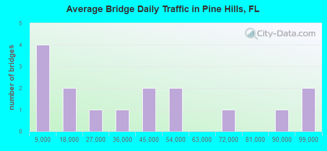
- 614,265Total average daily traffic
- 30,172Total average daily truck traffic
- National Bridge Inventory (NBI) Registered Bridges for Pine Hills
- No street view available for this location
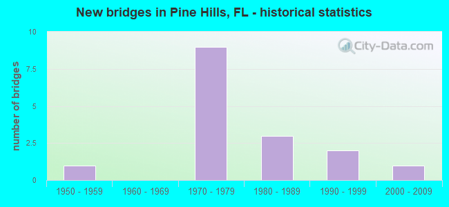
- New bridges - historical statistics
- 11950-1959
- 91970-1979
- 31980-1989
- 21990-1999
- 12000-2009
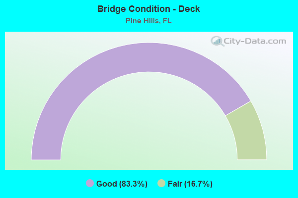
- Bridge Condition - Deck
- 83.3%Good
- 16.7%Fair
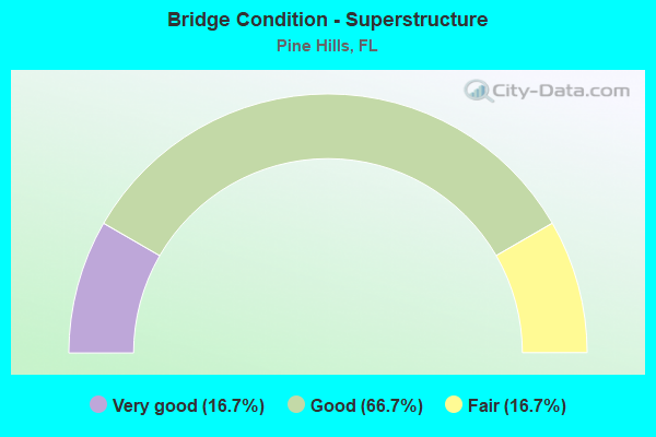
- Bridge Condition - Superstructure
- 16.7%Very good
- 66.7%Good
- 16.7%Fair
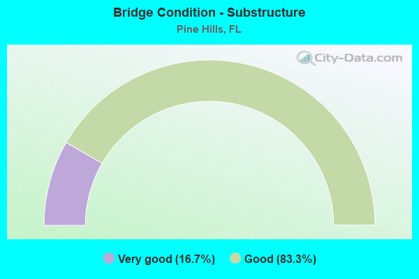
- Bridge Condition - Substructure
- 16.7%Very good
- 83.3%Good
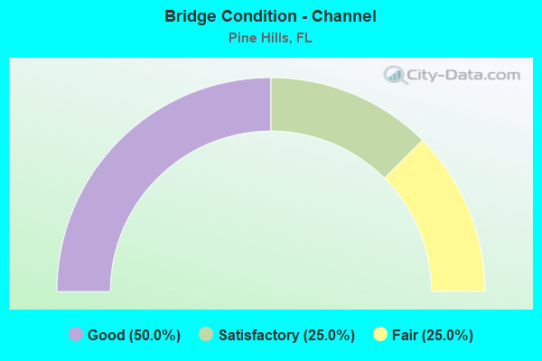
- Bridge Condition - Channel
- 50.0%Good
- 25.0%Satisfactory
- 25.0%Fair
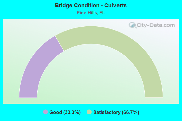
- Bridge Condition - Culverts
- 33.3%Good
- 66.7%Satisfactory
Find on map >> Show street view
Structure Number: 104135, Location: 0.2 MI SOUTH OF MLK BLVD (Lat: 27.978578, Lng: -82.341592), Route carried "on" structure: County highway , Year Built: 1987, Status: Open, Structure Length: 1.86m (6.10ft), Average Daily Traffic: 150 (year 2021), Truck Traffic: 5%, Average Future Daily Traffic: 260 (year 2042), Design Load: HS 20, Features Intersected: SIX MILE CREEK, Facility Carried by Structure: CRAGMONT DRIVE
Minimum Vertical Clearance: 30+ m (98+ ft), Kilometerpoint: 0.000, Lanes on structure: 2, Owner: County Highway Agency, Approaching Roadway Width: 9.4m (30.8ft), Skew: 1 degrees, Material/Design: Prestressed concrete, Design/Construction: Slab, Number Of Spans In Main Unit: 2, Length of Maximum Span: 9.3m (30.5ft), Curb-To-Curb Width: 12.1m (39.7ft), Out-to-Out Width: 13.0m (42.7ft)
Condition: Deck: Fair, Superstructure: Fair, Substructure: Very good, Channel: Fair, Operating Rating: 49.4 metric tons, Method Used To Determine Operating Rating: Load Factor (LF), Inventory Rating: 29.7 metric tons, Method Used To Determine Inventory Rating: Load Factor (LF), Structural Evaluation: Somewhat better than minimum adequacy, Deck Geometry: Superior to present desirable criteria, Waterway Adequacy: Superior to present desirable criteria, Approach Roadway Alignment: Equal to present desirable criteria, Designated Inspection Frequency: Every 24 months, Inspection Date: November 2021, Deck Structure Type: Concrete Precast Panels, Wearing Surface/Protective System: Wearing Surface: Bituminous
Find on map >> Show street view
Structure Number: 750103, Location: SR-408 WB - Ortman Drive (Lat: 28.546194, Lng: -81.430308), Route carried "on" structure: State highway 408, Year Built: 1973, Year Reconstructed: 2006, Status: Open, Structure Length: 6.13m (20.11ft), Average Daily Traffic: 47,750 (year 2020), Truck Traffic: 4%, Average Future Daily Traffic: 82,846 (year 2042), Design Load: HS 20, Features Intersected: Ortman Drive
Minimum Vertical Clearance: 30+ m (98+ ft), Kilometerpoint: 3.314, Lanes on structure: 3, Lanes under structure: 3, Base Highway Network: Yes, Toll: On toll road, Owner: State Toll Authority, Approaching Roadway Width: 16.2m (53.1ft), Skew: 1 degrees, Material/Design: Prestressed concrete, Design/Construction: Stringer/Multi-beam, Number Of Spans In Main Unit: 4, Length of Maximum Span: 18.4m (60.4ft), Curb-To-Curb Width: 17.4m (57.1ft), Out-to-Out Width: 18.4m (60.4ft)
Condition: Deck: Good, Superstructure: Good, Substructure: Good, Operating Rating: 47.4 metric tons, Method Used To Determine Operating Rating: Load Factor (LF), Inventory Rating: 32.7 metric tons, Method Used To Determine Inventory Rating: Load Factor (LF), Structural Evaluation: Better than present minimum criteria, Deck Geometry: Better than present minimum criteria, Underclear: Meets minimum limits, Approach Roadway Alignment: Equal to present desirable criteria, Designated Inspection Frequency: Every 24 months, Inspection Date: March 2021, Deck Structure Type: Concrete Cast-file-Place
Find on map >> Show street view
Structure Number: 750231, Location: SR-408 EB - Kirkman Rd. (Lat: 28.548892, Lng: -81.457206), Route carried "on" structure: State highway 408, Year Built: 1973, Year Reconstructed: 2006, Status: Open, Structure Length: 6.22m (20.41ft), Average Daily Traffic: 33,750 (year 2018), Truck Traffic: 5%, Average Future Daily Traffic: 58,556 (year 2040), Design Load: HS 20, Features Intersected: Kirkman Road
Minimum Vertical Clearance: 30+ m (98+ ft), Kilometerpoint: 0.615, Lanes on structure: 3, Lanes under structure: 8, Base Highway Network: Yes, Toll: On toll road, Owner: State Toll Authority, Approaching Roadway Width: 16.9m (55.4ft), Material/Design: Prestressed concrete, Design/Construction: Stringer/Multi-beam, Number Of Spans In Main Unit: 4, Length of Maximum Span: 17.5m (57.4ft), Curb-To-Curb Width: 16.9m (55.4ft), Out-to-Out Width: 17.8m (58.4ft)
Condition: Deck: Good, Superstructure: Good, Substructure: Good, Operating Rating: 46.4 metric tons, Method Used To Determine Operating Rating: Load Factor (LF), Inventory Rating: 35.9 metric tons, Method Used To Determine Inventory Rating: Load Factor (LF), Structural Evaluation: Better than present minimum criteria, Deck Geometry: Equal to present minimum criteria, Underclear: Meets minimum limits, Approach Roadway Alignment: Equal to present desirable criteria, Designated Inspection Frequency: Every 24 months, Inspection Date: Febuary 2021, Deck Structure Type: Concrete Cast-file-Place
Find on map >> Show street view
Structure Number: 750232, Location: SR-408 - Pine Hills Rd (Lat: 28.548297, Lng: -81.447511), Route carried "on" structure: State highway 408, Year Built: 1973, Year Reconstructed: 2006, Status: Open, Structure Length: 5.30m (17.39ft), Average Daily Traffic: 95,500 (year 2020), Truck Traffic: 4%, Average Future Daily Traffic: 165,692 (year 2042), Design Load: HS 20, Features Intersected: Pine Hills Road
Minimum Vertical Clearance: 30+ m (98+ ft), Kilometerpoint: 1.569, Lanes on structure: 8, Lanes under structure: 5, Base Highway Network: Yes, Toll: On toll road, Owner: State Toll Authority, Approaching Roadway Width: 41.5m (136.2ft), Skew: 30 degrees, Material/Design: Prestressed concrete, Design/Construction: Stringer/Multi-beam, Number Of Spans In Main Unit: 4, Length of Maximum Span: 17.7m (58.1ft), Curb-To-Curb Width: 41.5m (136.2ft), Out-to-Out Width: 43.0m (141.1ft)
Condition: Deck: Good, Superstructure: Good, Substructure: Good, Operating Rating: 40.2 metric tons, Method Used To Determine Operating Rating: Load Factor (LF), Inventory Rating: 34.3 metric tons, Method Used To Determine Inventory Rating: Load Factor (LF), Structural Evaluation: Better than present minimum criteria, Deck Geometry: Superior to present desirable criteria, Underclear: Equal to present minimum criteria, Approach Roadway Alignment: Equal to present desirable criteria, Designated Inspection Frequency: Every 24 months, Inspection Date: March 2021, Deck Structure Type: Concrete Cast-file-Place
Find on map >> Show street view
Structure Number: 750233, Location: SR-408 EB - Ortman Drive (Lat: 28.545983, Lng: -81.430317), Route carried "on" structure: State highway 408, Year Built: 1973, Year Reconstructed: 2006, Status: Open, Structure Length: 6.13m (20.11ft), Average Daily Traffic: 47,750 (year 2020), Truck Traffic: 4%, Average Future Daily Traffic: 82,846 (year 2042), Design Load: HS 20, Features Intersected: Ortman Drive
Minimum Vertical Clearance: 30+ m (98+ ft), Kilometerpoint: 3.314, Lanes on structure: 3, Lanes under structure: 3, Base Highway Network: Yes, Toll: On toll road, Owner: State Toll Authority, Approaching Roadway Width: 16.2m (53.1ft), Skew: 1 degrees, Material/Design: Prestressed concrete, Design/Construction: Stringer/Multi-beam, Number Of Spans In Main Unit: 4, Length of Maximum Span: 18.4m (60.4ft), Curb-To-Curb Width: 17.4m (57.1ft), Out-to-Out Width: 18.4m (60.4ft)
Condition: Deck: Good, Superstructure: Good, Substructure: Good, Operating Rating: 40.2 metric tons, Method Used To Determine Operating Rating: Load Factor (LF), Inventory Rating: 36.3 metric tons, Method Used To Determine Inventory Rating: Load Factor (LF), Structural Evaluation: Better than present minimum criteria, Deck Geometry: Better than present minimum criteria, Underclear: Meets minimum limits, Approach Roadway Alignment: Equal to present desirable criteria, Designated Inspection Frequency: Every 24 months, Inspection Date: March 2021, Deck Structure Type: Concrete Cast-file-Place
Find on map >> Show street view
Structure Number: 750306, Location: 200ft. E of SR-438 (Lat: 28.578008, Lng: -81.434431), Route carried "on" structure: Alternate State highway 416, Year Built: 1986, Status: Open, Structure Length: 0.77m (2.53ft), Average Daily Traffic: 15,300 (year 2020), Truck Traffic: 9%, Average Future Daily Traffic: 26,546 (year 2042), Design Load: HS 20, Features Intersected: Canal
Minimum Vertical Clearance: 30.45m (99.90ft), Kilometerpoint: 11.822, Lanes on structure: 2, Owner: State Highway Agency, Approaching Roadway Width: 16.2m (53.1ft), Material/Design: Concrete, Design/Construction: Culvert, Number Of Spans In Main Unit: 3, Length of Maximum Span: 2.4m (7.9ft)
Condition: Channel: Good, Culverts: Satisfactory, Inventory Rating: 63.2 metric tons, Method Used To Determine Inventory Rating: Load Factor (LF), Structural Evaluation: Equal to present minimum criteria, Waterway Adequacy: Equal to present desirable criteria, Approach Roadway Alignment: Equal to present desirable criteria, Designated Inspection Frequency: Every 24 months, Underwater Inspection Frequency: Every 24 months, Inspection Date: September 2021, Underwater Inspection Date: September 2021
Find on map >> Show street view
Structure Number: 750307, Location: .7 Mi East of Silver Star (Lat: 28.577303, Lng: -81.434447), Route carried "on" structure: State highway 438, Year Built: 1986, Status: Open, Structure Length: 0.94m (3.08ft), Average Daily Traffic: 23,500 (year 2020), Truck Traffic: 6%, Average Future Daily Traffic: 40,772 (year 2042), Design Load: HS 20+Mod, Features Intersected: Canal
Minimum Vertical Clearance: 30+ m (98+ ft), Kilometerpoint: 0.175, Lanes on structure: 6, Owner: State Highway Agency, Approaching Roadway Width: 22.9m (75.1ft), Skew: 23 degrees, Material/Design: Concrete, Design/Construction: Culvert, Number Of Spans In Main Unit: 3, Length of Maximum Span: 3.0m (9.8ft)
Condition: Channel: Good, Culverts: Satisfactory, Operating Rating: 74.1 metric tons, Method Used To Determine Operating Rating: Load and Resistance Factor (LRFR), Inventory Rating: 57.2 metric tons, Method Used To Determine Inventory Rating: Load and Resistance Factor (LRFR), Structural Evaluation: Equal to present minimum criteria, Waterway Adequacy: Equal to present desirable criteria, Approach Roadway Alignment: Equal to present desirable criteria, Designated Inspection Frequency: Every 24 months, Inspection Date: August 2021
Find on map >> Show street view
Structure Number: 750395, Location: Dorscher Rd - SR-408 (Lat: 28.549028, Lng: -81.483583), Route carried "on" structure: County highway , Year Built: 1990, Status: Open, Structure Length: 6.22m (20.41ft), Average Daily Traffic: 4,713 (year 2020), Truck Traffic: 5%, Average Future Daily Traffic: 5,448 (year 2042), Design Load: HS 20, Features Intersected: SR-408, Facility Carried by Structure: Dorscher Road
Minimum Vertical Clearance: 30+ m (98+ ft), Kilometerpoint: 1.123, Lanes on structure: 2, Lanes under structure: 8, Owner: State Toll Authority, Approaching Roadway Width: 11.6m (38.1ft), Skew: 2 degrees, Material/Design: Prestressed concrete, Design/Construction: Stringer/Multi-beam, Number Of Spans In Main Unit: 2, Length of Maximum Span: 30.8m (101.0ft), Curb or Sidewalk Widths: Left: 1.8m (5.9ft), Right: 1.8m (5.9ft), Curb-To-Curb Width: 13.1m (43.0ft), Out-to-Out Width: 18.0m (59.1ft)
Condition: Deck: Good, Superstructure: Very good, Substructure: Good, Inventory Rating: 66.0 metric tons, Method Used To Determine Inventory Rating: Load Factor (LF), Structural Evaluation: Better than present minimum criteria, Deck Geometry: Equal to present minimum criteria, Underclear: Better than present minimum criteria, Approach Roadway Alignment: Equal to present desirable criteria, Designated Inspection Frequency: Every 24 months, Inspection Date: May 2020, Deck Structure Type: Concrete Cast-file-Place
Find on map >> Show street view
Structure Number: 750488, Location: 150 ft. South of SR-91 (Lat: 28.429442, Lng: -81.404719), Route carried "on" structure: US 500, Year Built: 1955, Status: Open, Structure Length: 0.67m (2.20ft), Average Daily Traffic: 64,000 (year 2020), Truck Traffic: 5%, Average Future Daily Traffic: 111,040 (year 2042), Design Load: HS 20+Mod, Features Intersected: Canal, Facility Carried by Structure: US-441
Minimum Vertical Clearance: 30+ m (98+ ft), Kilometerpoint: 9.040, Lanes on structure: 7, Base Highway Network: Yes, Owner: State Highway Agency, Approaching Roadway Width: 31.3m (102.7ft), Skew: 10 degrees, Material/Design: Concrete, Design/Construction: Culvert, Number Of Spans In Main Unit: 2, Length of Maximum Span: 3.0m (9.8ft)
Condition: Channel: Satisfactory, Culverts: Good, Operating Rating: 59.9 metric tons, Method Used To Determine Operating Rating: Load Factor (LF), Inventory Rating: 35.9 metric tons, Method Used To Determine Inventory Rating: Load Factor (LF), Structural Evaluation: Better than present minimum criteria, Waterway Adequacy: Equal to present desirable criteria, Approach Roadway Alignment: Equal to present desirable criteria, Designated Inspection Frequency: Every 24 months, Underwater Inspection Frequency: Every 24 months, Inspection Date: January 2021, Underwater Inspection Date: January 2021
Find on map >> Show street view
Structure Number: 7501, Location: SR-408 WB - Kirkman Rd. (Lat: 28.549019, Lng: -81.457108), Route carried "under" structure: State highway 435, Year Built: 1973, Structure Length: 0. m, Average Daily Traffic: 38,000 (year 2020), Truck Traffic: 4%, Features Intersected: Kirkman Road, Facility Carried by Structure: SR-408 WB
Minimum Vertical Clearance: 4.97m (16.31ft), Kilometerpoint: 11.047, Lanes on structure: 3, Lanes under structure: 8, Material/Design: Prestressed concrete, Design/Construction: Stringer/Multi-beam, Length of Maximum Span: 17.5m (57.4ft)
Find on map >> Show street view
Structure Number: 750103, Location: SR-408 WB - Ortman Drive (Lat: 28.546194, Lng: -81.430308), Route carried "under" structure: City street , Year Built: 1973, Structure Length: 0. m, Average Daily Traffic: 3,226 (year 2020), Truck Traffic: 10%, Features Intersected: Ortman Drive, Facility Carried by Structure: SR-408 WB
Minimum Vertical Clearance: 4.69m (15.39ft), Kilometerpoint: 0.000, Lanes on structure: 3, Lanes under structure: 3, Material/Design: Prestressed concrete, Design/Construction: Stringer/Multi-beam, Length of Maximum Span: 18.4m (60.4ft)
Find on map >> Show street view
Structure Number: 750231, Location: SR-408 EB - Kirkman Rd. (Lat: 28.548892, Lng: -81.457206), Route carried "under" structure: State highway 435, Year Built: 1973, Structure Length: 0. m, Average Daily Traffic: 38,000 (year 2020), Truck Traffic: 4%, Features Intersected: Kirkman Road, Facility Carried by Structure: SR-408 EB
Minimum Vertical Clearance: 5.36m (17.59ft), Kilometerpoint: 11.029, Lanes on structure: 3, Lanes under structure: 8, Material/Design: Prestressed concrete, Design/Construction: Stringer/Multi-beam, Length of Maximum Span: 17.5m (57.4ft)
Find on map >> Show street view
Structure Number: 750232, Location: SR-408 - Pine Hills Rd (Lat: 28.548297, Lng: -81.447511), Route carried "under" structure: City street , Year Built: 1973, Structure Length: 0. m, Average Daily Traffic: 15,400 (year 2020), Truck Traffic: 7%, Features Intersected: Pine Hills Road, Facility Carried by Structure: SR-408
Minimum Vertical Clearance: 4.91m (16.11ft), Kilometerpoint: 0.697, Lanes on structure: 8, Lanes under structure: 5, Material/Design: Prestressed concrete, Design/Construction: Stringer/Multi-beam, Length of Maximum Span: 17.7m (58.1ft)
Find on map >> Show street view
Structure Number: 750233, Location: SR-408 EB - Ortman Drive (Lat: 28.545983, Lng: -81.430317), Route carried "under" structure: City street , Year Built: 1973, Structure Length: 0. m, Average Daily Traffic: 3,226 (year 2021), Truck Traffic: 5%, Features Intersected: Ortman Drive, Facility Carried by Structure: SR-408 EB
Minimum Vertical Clearance: 4.69m (15.39ft), Kilometerpoint: 0.000, Lanes on structure: 3, Lanes under structure: 3, Material/Design: Prestressed concrete, Design/Construction: Stringer/Multi-beam, Length of Maximum Span: 18.4m (60.4ft)
Find on map >> Show street view
Structure Number: 750395, Location: Dorscher Rd - SR-408 (Lat: 28.549028, Lng: -81.483583), Route carried "under" structure: State highway 408, Year Built: 1990, Structure Length: 0. m, Average Daily Traffic: 88,500 (year 2020), Truck Traffic: 7%, Features Intersected: SR-408, Facility Carried by Structure: Dorscher Road
Minimum Vertical Clearance: 5.30m (17.39ft), Kilometerpoint: 5.662, Lanes on structure: 2, Lanes under structure: 8, Toll: On toll road, Material/Design: Prestressed concrete, Design/Construction: Stringer/Multi-beam, Length of Maximum Span: 30.8m (101.0ft)
Find on map >> Show street view
Structure Number: 759011, Location: 0.4 MI E of Pine Hills Rd (Lat: 28.547967, Lng: -81.440133), Route carried "under" structure: State highway 408, Year Built: 2007, Structure Length: 0. m, Average Daily Traffic: 95,500 (year 2020), Truck Traffic: 4%, Features Intersected: SR-408, Facility Carried by Structure: Toll Plaza Bridge
Minimum Vertical Clearance: 5.36m (17.59ft), Kilometerpoint: 2.334, Lanes under structure: 14, Toll: On toll road, Material/Design: Steel continuous, Design/Construction: Truss - Thru, Length of Maximum Span: 25.9m (85.0ft)