Bridge Statistics for Perryville, Missouri (MO)
Condition, Traffic, Stress, Structural Evaluation, Project Costs
- National Bridge Inventory (NBI) Statistics
- 20Number of bridges
- 194ft / 58.8mTotal length
- $5,014,000Total costs
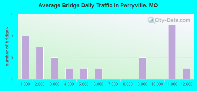
- 102,799Total average daily traffic
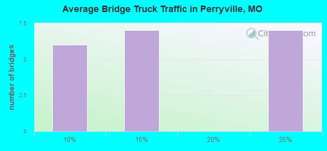
- 18,413Total average daily truck traffic
- National Bridge Inventory (NBI) Registered Bridges for Perryville
- No street view available for this location
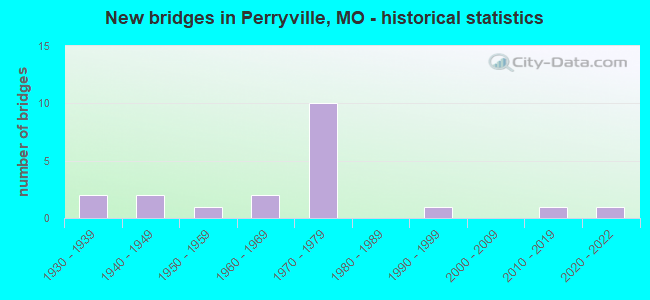
- New bridges - historical statistics
- 21930-1939
- 21940-1949
- 11950-1959
- 21960-1969
- 101970-1979
- 11990-1999
- 12010-2019
- 12020-2022
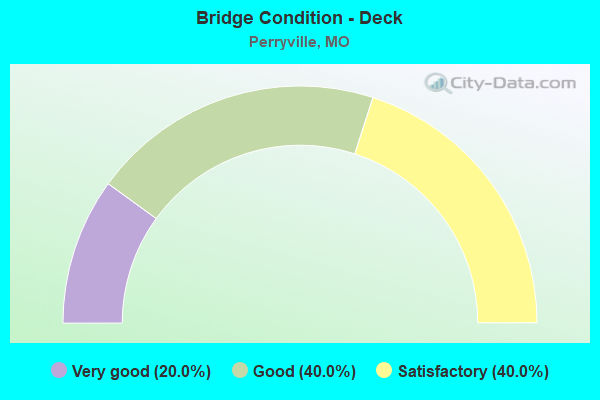
- Bridge Condition - Deck
- 20.0%Very good
- 40.0%Good
- 40.0%Satisfactory
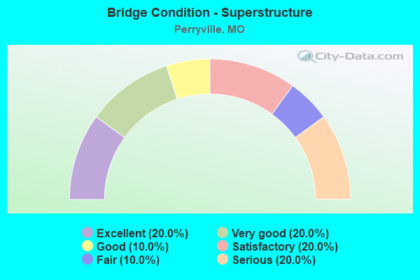
- Bridge Condition - Superstructure
- 20.0%Excellent
- 20.0%Very good
- 10.0%Good
- 20.0%Satisfactory
- 10.0%Fair
- 20.0%Serious
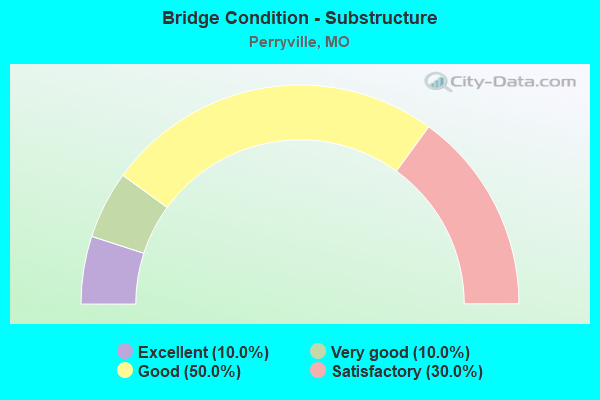
- Bridge Condition - Substructure
- 10.0%Excellent
- 10.0%Very good
- 50.0%Good
- 30.0%Satisfactory
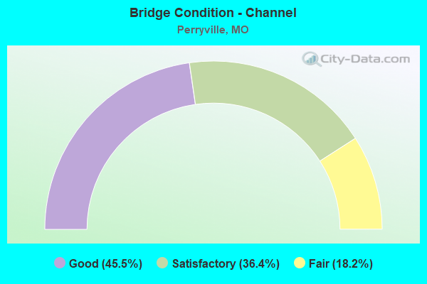
- Bridge Condition - Channel
- 45.5%Good
- 36.4%Satisfactory
- 18.2%Fair
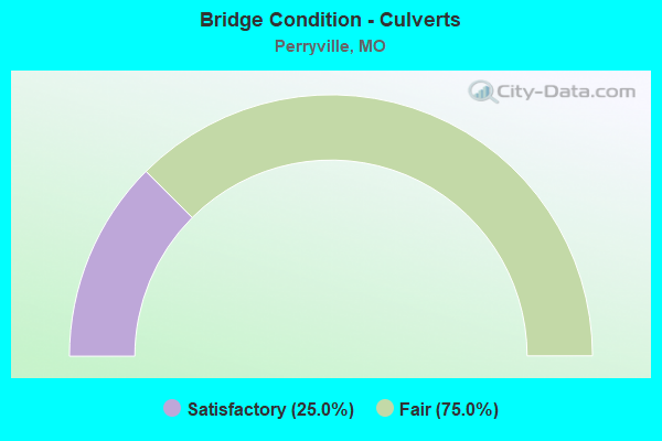
- Bridge Condition - Culverts
- 25.0%Satisfactory
- 75.0%Fair
Find on map >> Show street view
Structure Number: 15838, Location: S 26 T 35 N R 10 E (Lat: 37.713003, Lng: -89.906858), Route carried "on" structure: County highway 101, Year Built: 1950, Status: Open, Structure Length: 0.94m (3.08ft), Average Daily Traffic: 50 (year 2021), Truck Traffic: 10%, Average Future Daily Traffic: 68 (year 2041), Features Intersected: PERRYVILLE COMM LK, Facility Carried by Structure: COUNTY RD 702
Minimum Vertical Clearance: 30+ m (98+ ft), Kilometerpoint: 3.541, Lanes on structure: 1, Owner: County Highway Agency, Approaching Roadway Width: 6.1m (20.0ft), Material/Design: Steel, Design/Construction: Stringer/Multi-beam, Number Of Spans In Main Unit: 1, Length of Maximum Span: 8.8m (28.9ft), Curb-To-Curb Width: 4.2m (13.8ft), Out-to-Out Width: 4.2m (13.8ft)
Condition: Deck: Satisfactory, Superstructure: Satisfactory, Substructure: Satisfactory, Channel: Fair, Operating Rating: 41.4 metric tons, Method Used To Determine Operating Rating: Allowable Stress (AS), Inventory Rating: 25.2 metric tons, Method Used To Determine Inventory Rating: Allowable Stress (AS), Structural Evaluation: Equal to present minimum criteria, Deck Geometry: Somewhat better than minimum adequacy, Waterway Adequacy: Somewhat better than minimum adequacy, Approach Roadway Alignment: Equal to present minimum criteria, Designated Inspection Frequency: Every 24 months, Inspection Date: January 2021, Deck Structure Type: Concrete Cast-file-Place, Wearing Surface/Protective System: Wearing Surface: Monolithic Concrete
Find on map >> Show street view
Structure Number: 20403, Location: S 1 T 34 N R 10 E (Lat: 37.682989, Lng: -89.880200), Route carried "on" structure: County highway 258, Year Built: 1940, Status: Posted for load, Structure Length: 1.13m (3.71ft), Average Daily Traffic: 15 (year 2021), Truck Traffic: 10%, Average Future Daily Traffic: 20 (year 2041), Features Intersected: HIGHLAND CR, Facility Carried by Structure: COUNTY RD 600
Minimum Vertical Clearance: 30+ m (98+ ft), Kilometerpoint: 3.380, Lanes on structure: 2, Owner: County Highway Agency, Approaching Roadway Width: 6.7m (22.0ft), Skew: 3 degrees, Material/Design: Steel, Design/Construction: Girder and Floorbeam System, Number Of Spans In Main Unit: 1, Length of Maximum Span: 10.1m (33.1ft), Curb-To-Curb Width: 5.8m (19.0ft), Out-to-Out Width: 6.1m (20.0ft)
Condition: Deck: Satisfactory, Superstructure: Satisfactory, Substructure: Satisfactory, Channel: Good, Operating Rating: 22.5 metric tons, Method Used To Determine Operating Rating: Allowable Stress (AS), Inventory Rating: 13.5 metric tons, Method Used To Determine Inventory Rating: Allowable Stress (AS), Structural Evaluation: Meets minimum limits, Deck Geometry: Meets minimum limits, Waterway Adequacy: Better than present minimum criteria, Approach Roadway Alignment: Better than present minimum criteria, Bridge Posting: Required (Relationship of Operating Rating to Maximum Legal Load: 0.1 - 9.9% below), Designated Inspection Frequency: Every 24 months, Critical Feature Inspection Frequency: Every 24 months, Inspection Date: January 2021, Critical Feature Inspection Date: January 2021, Deck Structure Type: Concrete Cast-file-Place, Wearing Surface/Protective System: Wearing Surface: Bituminous
Find on map >> Show street view
Structure Number: 2137, Location: S 840 T 35 N R 10 E (Lat: 37.729575, Lng: -89.904094), Route carried "on" structure: State highway T, Year Built: 1970, Year Reconstructed: 1984, Status: Open, Structure Length: 9.20m (30.18ft), Average Daily Traffic: 5,040 (year 2021), Truck Traffic: 5%, Average Future Daily Traffic: 6,804 (year 2041), Design Load: H 20, Features Intersected: IS 55
Minimum Vertical Clearance: 30+ m (98+ ft), Kilometerpoint: 42.926, Lanes on structure: 2, Lanes under structure: 4, Owner: State Highway Agency, Approaching Roadway Width: 11.6m (38.1ft), Skew: 3 degrees, Material/Design: Steel continuous, Design/Construction: Stringer/Multi-beam, Number Of Spans In Main Unit: 4, Length of Maximum Span: 30.8m (101.0ft), Curb-To-Curb Width: 11.6m (38.1ft), Out-to-Out Width: 12.4m (40.7ft)
Condition: Deck: Satisfactory, Superstructure: Serious, Substructure: Good, Operating Rating: 42.3 metric tons, Method Used To Determine Operating Rating: Load Factor (LF), Inventory Rating: 25.2 metric tons, Method Used To Determine Inventory Rating: Load Factor (LF), Structural Evaluation: High priority of corrective action, Deck Geometry: Somewhat better than minimum adequacy, Underclear: Equal to present minimum criteria, Approach Roadway Alignment: Equal to present desirable criteria, Length Of Structure Improvement: 1.02m (3.35ft), Designated Inspection Frequency: Every 24 months, Other Special Inspection Frequency: Every 24 months, Inspection Date: September 2021, Other Special Inspection Date: September 2021, Bridge Improvement Cost: $1,286,000, Roadway Improvement Cost: $129,000, Total Project Cost: $1,929,000 ( Estimate for 2022), Deck Structure Type: Concrete Cast-file-Place, Wearing Surface/Protective System: Wearing Surface: Low Slump Concrete
Find on map >> Show street view
Structure Number: 2138, Location: S 843 T 35 N R 10 E (Lat: 37.709472, Lng: -89.891911), Route carried "on" structure: State highway 51, Year Built: 1970, Year Reconstructed: 1984, Status: Open, Structure Length: 8.99m (29.49ft), Average Daily Traffic: 11,186 (year 2021), Truck Traffic: 11%, Average Future Daily Traffic: 15,101 (year 2041), Design Load: H 20, Features Intersected: IS 55
Minimum Vertical Clearance: 30+ m (98+ ft), Kilometerpoint: 23.759, Lanes on structure: 2, Lanes under structure: 4, Base Highway Network: Yes, Owner: State Highway Agency, Approaching Roadway Width: 13.4m (44.0ft), Skew: 3 degrees, Material/Design: Steel continuous, Design/Construction: Stringer/Multi-beam, Number Of Spans In Main Unit: 4, Length of Maximum Span: 31.7m (104.0ft), Curb-To-Curb Width: 13.4m (44.0ft), Out-to-Out Width: 14.2m (46.6ft)
Condition: Deck: Good, Superstructure: Serious, Substructure: Satisfactory, Operating Rating: 40.5 metric tons, Method Used To Determine Operating Rating: Load Factor (LF), Inventory Rating: 24.3 metric tons, Method Used To Determine Inventory Rating: Load Factor (LF), Structural Evaluation: High priority of corrective action, Deck Geometry: Equal to present minimum criteria, Underclear: Somewhat better than minimum adequacy, Approach Roadway Alignment: Equal to present desirable criteria, Length Of Structure Improvement: 1.00m (3.28ft), Designated Inspection Frequency: Every 24 months, Other Special Inspection Frequency: Every 24 months, Inspection Date: September 2021, Other Special Inspection Date: September 2021, Bridge Improvement Cost: $1,377,000, Roadway Improvement Cost: $138,000, Total Project Cost: $2,066,000 ( Estimate for 2022), Deck Structure Type: Concrete Cast-file-Place, Wearing Surface/Protective System: Wearing Surface: Bituminous
Find on map >> Show street view
Structure Number: 2156, Location: S 36 T 35 N R 10 E (Lat: 37.696361, Lng: -89.880850), Route carried "on" structure: Interstate 55, Year Built: 1971, Year Reconstructed: 1984, Status: Open, Structure Length: 6.43m (21.10ft), Average Daily Traffic: 10,829 (year 2021), Truck Traffic: 22%, Average Future Daily Traffic: 20,575 (year 2041), Design Load: HS 20+Mod, Features Intersected: TYLER BR
Minimum Vertical Clearance: 30+ m (98+ ft), Kilometerpoint: 130.463, Lanes on structure: 2, Base Highway Network: Yes, Owner: State Highway Agency, Approaching Roadway Width: 11.6m (38.1ft), Skew: 4 degrees, Material/Design: Steel continuous, Design/Construction: Stringer/Multi-beam, Number Of Spans In Main Unit: 3, Length of Maximum Span: 25.0m (82.0ft), Curb-To-Curb Width: 11.6m (38.1ft), Out-to-Out Width: 12.4m (40.7ft)
Condition: Deck: Good, Superstructure: Good, Substructure: Good, Channel: Good, Operating Rating: 52.2 metric tons, Method Used To Determine Operating Rating: Load Factor (LF), Inventory Rating: 31.5 metric tons, Method Used To Determine Inventory Rating: Load Factor (LF), Structural Evaluation: Better than present minimum criteria, Deck Geometry: Equal to present minimum criteria, Waterway Adequacy: Equal to present desirable criteria, Approach Roadway Alignment: Equal to present desirable criteria, Designated Inspection Frequency: Every 24 months, Inspection Date: October 2021, Deck Structure Type: Concrete Cast-file-Place, Wearing Surface/Protective System: Wearing Surface: Low Slump Concrete, Membrane: Built-up, Deck Protection: Internally Sealed
Find on map >> Show street view
Structure Number: 2158, Location: S 36 T 35 N R 10 E (Lat: 37.688547, Lng: -89.874711), Route carried "on" structure: State highway K, Year Built: 1970, Year Reconstructed: 1984, Status: Open, Structure Length: 8.23m (27.00ft), Average Daily Traffic: 1,070 (year 2021), Truck Traffic: 7%, Average Future Daily Traffic: 1,498 (year 2041), Design Load: H 15, Features Intersected: IS 55
Minimum Vertical Clearance: 30+ m (98+ ft), Kilometerpoint: 0.303, Lanes on structure: 2, Lanes under structure: 4, Owner: State Highway Agency, Approaching Roadway Width: 6.7m (22.0ft), Skew: 2 degrees, Material/Design: Steel continuous, Design/Construction: Stringer/Multi-beam, Number Of Spans In Main Unit: 4, Length of Maximum Span: 28.0m (91.9ft), Curb-To-Curb Width: 10.4m (34.1ft), Out-to-Out Width: 11.2m (36.7ft)
Condition: Deck: Good, Superstructure: Fair, Substructure: Good, Operating Rating: 28.8 metric tons, Method Used To Determine Operating Rating: Allowable Stress (AS), Inventory Rating: 16.2 metric tons, Method Used To Determine Inventory Rating: Allowable Stress (AS), Structural Evaluation: Meets minimum limits, Deck Geometry: Equal to present minimum criteria, Underclear: Better than present minimum criteria, Approach Roadway Alignment: Equal to present desirable criteria, Designated Inspection Frequency: Every 24 months, Other Special Inspection Frequency: Every 24 months, Inspection Date: September 2021, Other Special Inspection Date: September 2021, Deck Structure Type: Concrete Cast-file-Place, Wearing Surface/Protective System: Wearing Surface: Low Slump Concrete
Find on map >> Show street view
Structure Number: 33957, Location: S 856 T 35 N R 10 E (Lat: 37.737053, Lng: -89.928028), Route carried "on" structure: State highway T, Year Built: 2012, Status: Open, Structure Length: 6.83m (22.41ft), Average Daily Traffic: 2,038 (year 2021), Truck Traffic: 11%, Average Future Daily Traffic: 2,853 (year 2041), Features Intersected: SALINE CR
Minimum Vertical Clearance: 30+ m (98+ ft), Kilometerpoint: 40.531, Lanes on structure: 2, Owner: State Highway Agency, Approaching Roadway Width: 8.5m (27.9ft), Material/Design: Prestressed concrete, Design/Construction: Tee Beam, Number Of Spans In Main Unit: 3, Length of Maximum Span: 25.9m (85.0ft), Curb-To-Curb Width: 8.5m (27.9ft), Out-to-Out Width: 9.3m (30.5ft)
Condition: Deck: Very good, Superstructure: Excellent, Substructure: Excellent, Channel: Good, Operating Rating: 63.0 metric tons, Method Used To Determine Operating Rating: Load Factor (LF), Inventory Rating: 37.8 metric tons, Method Used To Determine Inventory Rating: Load Factor (LF), Structural Evaluation: Superior to present desirable criteria, Deck Geometry: Meets minimum limits, Waterway Adequacy: Superior to present desirable criteria, Approach Roadway Alignment: Equal to present desirable criteria, Designated Inspection Frequency: Every 24 months, Inspection Date: October 2021, Deck Structure Type: Concrete Cast-file-Place, Wearing Surface/Protective System: Wearing Surface: Monolithic Concrete, Deck Protection: Epoxy Coated Reinforcing
Find on map >> Show street view
Structure Number: 3662, Location: S 14 T 34 N R 10 E (Lat: 37.654719, Lng: -89.898658), Route carried "on" structure: County highway 253, Year Built: 2021, Status: Open, Structure Length: 2.07m (6.79ft), Average Daily Traffic: 10 (year 2021), Truck Traffic: 10%, Average Future Daily Traffic: 14 (year 2041), Design Load: HS 20, Features Intersected: APPLE CR, Facility Carried by Structure: COLER ST
Minimum Vertical Clearance: 30+ m (98+ ft), Kilometerpoint: 0.805, Lanes on structure: 2, Owner: County Highway Agency, Approaching Roadway Width: 7.3m (24.0ft), Material/Design: Prestressed concrete, Design/Construction: Box Beam or Girders - Multiple, Number Of Spans In Main Unit: 1, Length of Maximum Span: 19.8m (65.0ft), Curb-To-Curb Width: 6.9m (22.6ft), Out-to-Out Width: 7.4m (24.3ft)
Condition: Deck: Very good, Superstructure: Very good, Substructure: Very good, Channel: Good, Operating Rating: 54.0 metric tons, Method Used To Determine Operating Rating: Load Factor (LF), Inventory Rating: 32.4 metric tons, Method Used To Determine Inventory Rating: Load Factor (LF), Structural Evaluation: Equal to present desirable criteria, Deck Geometry: Somewhat better than minimum adequacy, Waterway Adequacy: Equal to present minimum criteria, Approach Roadway Alignment: Equal to present minimum criteria, Designated Inspection Frequency: Every 24 months, Inspection Date: January 2021, Deck Structure Type: Concrete Precast Panels, Wearing Surface/Protective System: Wearing Surface: Bituminous
Find on map >> Show street view
Structure Number: 4355, Location: S 28 T 35 N R 11 E (Lat: 37.710983, Lng: -89.830761), Route carried "on" structure: US 61, Year Built: 1996, Status: Open, Structure Length: 6.98m (22.90ft), Average Daily Traffic: 4,333 (year 2021), Truck Traffic: 8%, Average Future Daily Traffic: 6,066 (year 2041), Design Load: HS 20, Features Intersected: CINQUE HOMMES CR
Minimum Vertical Clearance: 30+ m (98+ ft), Kilometerpoint: 406.867, Lanes on structure: 2, Owner: State Highway Agency, Approaching Roadway Width: 11.0m (36.1ft), Skew: 2 degrees, Material/Design: Prestressed concrete continuous, Design/Construction: Stringer/Multi-beam, Number Of Spans In Main Unit: 4, Length of Maximum Span: 18.5m (60.7ft), Curb or Sidewalk Widths: Left: 0.2m (0.7ft), Right: 0.2m (0.7ft), Curb-To-Curb Width: 15.1m (49.5ft), Out-to-Out Width: 15.9m (52.2ft)
Condition: Deck: Good, Superstructure: Excellent, Substructure: Good, Channel: Satisfactory, Operating Rating: 84.6 metric tons, Method Used To Determine Operating Rating: Load Factor (LF), Inventory Rating: 50.4 metric tons, Method Used To Determine Inventory Rating: Load Factor (LF), Structural Evaluation: Better than present minimum criteria, Deck Geometry: Superior to present desirable criteria, Waterway Adequacy: Equal to present desirable criteria, Approach Roadway Alignment: Equal to present desirable criteria, Designated Inspection Frequency: Every 24 months, Inspection Date: October 2021, Deck Structure Type: Concrete Cast-file-Place, Wearing Surface/Protective System: Wearing Surface: Monolithic Concrete, Deck Protection: Internally Sealed
Find on map >> Show street view
Structure Number: 5494, Location: S 34 T 35 N R 10 E (Lat: 37.689808, Lng: -89.911439), Route carried "on" structure: State highway 51, Year Built: 1932, Status: Open, Structure Length: 0.65m (2.13ft), Average Daily Traffic: 2,344 (year 2021), Truck Traffic: 12%, Average Future Daily Traffic: 3,164 (year 2041), Design Load: H 15, Features Intersected: ZANNER BR
Minimum Vertical Clearance: 30+ m (98+ ft), Kilometerpoint: 26.652, Lanes on structure: 2, Base Highway Network: Yes, Owner: State Highway Agency, Approaching Roadway Width: 10.4m (34.1ft), Skew: 3 degrees, Material/Design: Concrete continuous, Design/Construction: Culvert, Number Of Spans In Main Unit: 2, Length of Maximum Span: 2.4m (7.9ft), Curb-To-Curb Width: 11.6m (38.1ft), Out-to-Out Width: 12.2m (40.0ft)
Condition: Channel: Good, Culverts: Fair, Operating Rating: 61.2 metric tons, Method Used To Determine Operating Rating: Load Factor (LF), Inventory Rating: 36.9 metric tons, Method Used To Determine Inventory Rating: Load Factor (LF), Structural Evaluation: Somewhat better than minimum adequacy, Deck Geometry: Somewhat better than minimum adequacy, Waterway Adequacy: Equal to present desirable criteria, Approach Roadway Alignment: Equal to present desirable criteria, Designated Inspection Frequency: Every 24 months, Inspection Date: October 2021
Find on map >> Show street view
Structure Number: 612, Location: S 2146 T 35 N R 11 E (Lat: 37.710567, Lng: -89.861847), Route carried "on" structure: State highway B, Year Built: 1963, Status: Open, Structure Length: 4.39m (14.40ft), Average Daily Traffic: 3,204 (year 2021), Truck Traffic: 7%, Average Future Daily Traffic: 4,486 (year 2041), Design Load: H 15, Features Intersected: CINQUE CR
Minimum Vertical Clearance: 30+ m (98+ ft), Kilometerpoint: 2.433, Lanes on structure: 2, Owner: State Highway Agency, Approaching Roadway Width: 6.7m (22.0ft), Skew: 2 degrees, Material/Design: Steel continuous, Design/Construction: Stringer/Multi-beam, Number Of Spans In Main Unit: 3, Length of Maximum Span: 18.3m (60.0ft), Curb-To-Curb Width: 7.3m (24.0ft), Out-to-Out Width: 8.4m (27.6ft)
Condition: Deck: Satisfactory, Superstructure: Very good, Substructure: Good, Channel: Fair, Operating Rating: 24.3 metric tons, Method Used To Determine Operating Rating: Load Factor (LF), Inventory Rating: 14.4 metric tons, Method Used To Determine Inventory Rating: Load Factor (LF), Structural Evaluation: Meets minimum limits, Deck Geometry: High priority of replacement, Waterway Adequacy: Somewhat better than minimum adequacy, Approach Roadway Alignment: Equal to present minimum criteria, Bridge Posting: Required (Relationship of Operating Rating to Maximum Legal Load: 10.0 - 19.9% below), Length Of Structure Improvement: 0.54m (1.77ft), Designated Inspection Frequency: Every 24 months, Inspection Date: October 2021, Bridge Improvement Cost: $680,000, Roadway Improvement Cost: $68,000, Total Project Cost: $1,019,000 ( Estimate for 2022), Deck Structure Type: Concrete Cast-file-Place, Wearing Surface/Protective System: Wearing Surface: Bituminous, Membrane: Built-up
Find on map >> Show street view
Structure Number: 6235, Location: S 20 T 35 N R 11 E (Lat: 37.727539, Lng: -89.848781), Route carried "on" structure: State highway E, Year Built: 1949, Status: Open, Structure Length: 0.96m (3.15ft), Average Daily Traffic: 697 (year 2021), Truck Traffic: 11%, Average Future Daily Traffic: 976 (year 2041), Design Load: H 15, Features Intersected: APPLE CR
Minimum Vertical Clearance: 30+ m (98+ ft), Kilometerpoint: 15.413, Lanes on structure: 2, Owner: State Highway Agency, Approaching Roadway Width: 7.3m (24.0ft), Material/Design: Concrete continuous, Design/Construction: Culvert, Number Of Spans In Main Unit: 3, Length of Maximum Span: 3.0m (9.8ft), Curb-To-Curb Width: 8.2m (26.9ft), Out-to-Out Width: 8.8m (28.9ft)
Condition: Channel: Satisfactory, Culverts: Satisfactory, Operating Rating: 55.8 metric tons, Method Used To Determine Operating Rating: Load Factor (LF), Inventory Rating: 33.3 metric tons, Method Used To Determine Inventory Rating: Load Factor (LF), Structural Evaluation: Equal to present minimum criteria, Deck Geometry: Somewhat better than minimum adequacy, Waterway Adequacy: Equal to present desirable criteria, Approach Roadway Alignment: Equal to present desirable criteria, Designated Inspection Frequency: Every 24 months, Inspection Date: October 2021
Find on map >> Show street view
Structure Number: 7322, Location: S 13 T 34 N R 10 E (Lat: 37.645336, Lng: -89.889958), Route carried "on" structure: State highway K, Year Built: 1960, Status: Open, Structure Length: 1.33m (4.36ft), Average Daily Traffic: 1,070 (year 2021), Truck Traffic: 7%, Average Future Daily Traffic: 1,498 (year 2041), Design Load: H 15, Features Intersected: APPLE CR
Minimum Vertical Clearance: 30+ m (98+ ft), Kilometerpoint: 5.844, Lanes on structure: 2, Owner: State Highway Agency, Approaching Roadway Width: 7.3m (24.0ft), Material/Design: Concrete continuous, Design/Construction: Culvert, Number Of Spans In Main Unit: 3, Length of Maximum Span: 4.3m (14.1ft), Curb-To-Curb Width: 7.9m (25.9ft), Out-to-Out Width: 8.5m (27.9ft)
Condition: Channel: Satisfactory, Culverts: Fair, Operating Rating: 63.0 metric tons, Method Used To Determine Operating Rating: Load Factor (LF), Inventory Rating: 37.8 metric tons, Method Used To Determine Inventory Rating: Load Factor (LF), Structural Evaluation: Somewhat better than minimum adequacy, Deck Geometry: Meets minimum limits, Waterway Adequacy: Equal to present minimum criteria, Approach Roadway Alignment: Equal to present desirable criteria, Designated Inspection Frequency: Every 24 months, Inspection Date: October 2021
Find on map >> Show street view
Structure Number: 9523, Location: S 7 T 34 N R 11 E (Lat: 37.671908, Lng: -89.857242), Route carried "on" structure: State highway B, Year Built: 1938, Status: Open, Structure Length: 0.65m (2.13ft), Average Daily Traffic: 1,032 (year 2021), Truck Traffic: 7%, Average Future Daily Traffic: 1,445 (year 2041), Design Load: H 10, Features Intersected: SHAWNEE BR
Minimum Vertical Clearance: 30+ m (98+ ft), Kilometerpoint: 7.683, Lanes on structure: 2, Owner: State Highway Agency, Approaching Roadway Width: 7.3m (24.0ft), Skew: 1 degrees, Material/Design: Concrete continuous, Design/Construction: Culvert, Number Of Spans In Main Unit: 2, Length of Maximum Span: 3.0m (9.8ft), Curb-To-Curb Width: 8.4m (27.6ft), Out-to-Out Width: 9.0m (29.5ft)
Condition: Channel: Satisfactory, Culverts: Fair, Operating Rating: 39.6 metric tons, Method Used To Determine Operating Rating: Load Factor (LF), Inventory Rating: 23.4 metric tons, Method Used To Determine Inventory Rating: Load Factor (LF), Structural Evaluation: Somewhat better than minimum adequacy, Deck Geometry: Meets minimum limits, Waterway Adequacy: Equal to present desirable criteria, Approach Roadway Alignment: Equal to present minimum criteria, Designated Inspection Frequency: Every 24 months, Inspection Date: October 2021
Find on map >> Show street view
Structure Number: 2137, Location: S 840 T 35 N R 10 E (Lat: 37.729575, Lng: -89.904094), Route carried "under" structure: Interstate 55, Year Built: 1970, Structure Length: 0. m, Average Daily Traffic: 8,853 (year 2021), Truck Traffic: 22%, Features Intersected: IS 55, Facility Carried by Structure: RT T E
Minimum Vertical Clearance: 5.08m (16.67ft), Kilometerpoint: 126.244, Lanes on structure: 2, Lanes under structure: 2, Material/Design: Steel continuous, Design/Construction: Stringer/Multi-beam, Length of Maximum Span: 30.8m (101.0ft)
Find on map >> Show street view
Structure Number: 2137, Location: S 840 T 35 N R 10 E (Lat: 37.729575, Lng: -89.904094), Route carried "under" structure: Interstate 55, Year Built: 1970, Structure Length: 0. m, Average Daily Traffic: 10,052 (year 2021), Truck Traffic: 22%, Features Intersected: IS 55, Facility Carried by Structure: RT T E
Minimum Vertical Clearance: 5.89m (19.32ft), Kilometerpoint: 211.463, Lanes on structure: 2, Lanes under structure: 2, Material/Design: Steel continuous, Design/Construction: Stringer/Multi-beam, Length of Maximum Span: 30.8m (101.0ft)
Find on map >> Show street view
Structure Number: 2138, Location: S 843 T 35 N R 10 E (Lat: 37.709472, Lng: -89.891911), Route carried "under" structure: Interstate 55, Year Built: 1970, Structure Length: 0. m, Average Daily Traffic: 8,853 (year 2021), Truck Traffic: 22%, Features Intersected: IS 55, Facility Carried by Structure: MO 51 S
Minimum Vertical Clearance: 5.13m (16.83ft), Kilometerpoint: 128.743, Lanes on structure: 2, Lanes under structure: 2, Material/Design: Steel continuous, Design/Construction: Stringer/Multi-beam, Length of Maximum Span: 31.7m (104.0ft)
Find on map >> Show street view
Structure Number: 2138, Location: S 843 T 35 N R 10 E (Lat: 37.709472, Lng: -89.891911), Route carried "under" structure: Interstate 55, Year Built: 1970, Structure Length: 0. m, Average Daily Traffic: 10,647 (year 2021), Truck Traffic: 22%, Features Intersected: IS 55, Facility Carried by Structure: MO 51 S
Minimum Vertical Clearance: 4.80m (15.75ft), Kilometerpoint: 209.003, Lanes on structure: 2, Lanes under structure: 2, Material/Design: Steel continuous, Design/Construction: Stringer/Multi-beam, Length of Maximum Span: 31.7m (104.0ft)
Find on map >> Show street view
Structure Number: 2158, Location: S 36 T 35 N R 10 E (Lat: 37.688547, Lng: -89.874711), Route carried "under" structure: Interstate 55, Year Built: 1970, Structure Length: 0. m, Average Daily Traffic: 10,647 (year 2021), Truck Traffic: 22%, Features Intersected: IS 55, Facility Carried by Structure: RT K S
Minimum Vertical Clearance: 5.66m (18.57ft), Kilometerpoint: 206.210, Lanes on structure: 2, Lanes under structure: 2, Material/Design: Steel continuous, Design/Construction: Stringer/Multi-beam, Length of Maximum Span: 28.0m (91.9ft)
Find on map >> Show street view
Structure Number: 2158, Location: S 36 T 35 N R 10 E (Lat: 37.688547, Lng: -89.874711), Route carried "under" structure: Interstate 55, Year Built: 1970, Structure Length: 0. m, Average Daily Traffic: 10,829 (year 2021), Truck Traffic: 22%, Features Intersected: IS 55, Facility Carried by Structure: RT K S
Minimum Vertical Clearance: 5.16m (16.93ft), Kilometerpoint: 131.524, Lanes on structure: 2, Lanes under structure: 2, Material/Design: Steel continuous, Design/Construction: Stringer/Multi-beam, Length of Maximum Span: 28.0m (91.9ft)