Bridge Statistics for Panama City Beach, Florida (FL)
Condition, Traffic, Stress, Structural Evaluation, Project Costs
- National Bridge Inventory (NBI) Statistics
- 22Number of bridges
- 1,572ft / 479mTotal length
- 225,100Total average daily traffic
- 14,043Total average daily truck traffic
- National Bridge Inventory (NBI) Registered Bridges for Panama City Beach
- No street view available for this location
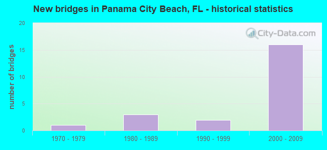
- New bridges - historical statistics
- 11970-1979
- 31980-1989
- 21990-1999
- 162000-2009


- Bridge Condition - Deck
- 83.3%Good
- 16.7%Satisfactory

- Bridge Condition - Superstructure
- 50.0%Good
- 50.0%Satisfactory

- Bridge Condition - Channel
- 14.3%Excellent
- 57.1%Very good
- 14.3%Good
- 14.3%Satisfactory

- Bridge Condition - Culverts
- 33.3%Good
- 66.7%Satisfactory
Find on map >> Show street view
Structure Number: 460077, Location: 4.6Mi N of SR30A WestBay (Lat: 30.294819, Lng: -85.857794), Route carried "on" structure: State highway 79, Year Built: 1993, Status: Open, Structure Length: 82.51m (270.70ft), Average Daily Traffic: 7,100 (year 2020), Truck Traffic: 6%, Average Future Daily Traffic: 12,318 (year 2042), Design Load: HS 20+Mod, Features Intersected: ICWW at West Bay
Minimum Vertical Clearance: 30+ m (98+ ft), Kilometerpoint: 8.267, Lanes on structure: 2, Lanes under structure: 2, Base Highway Network: Yes, Owner: State Highway Agency, Approaching Roadway Width: 7.3m (24.0ft), Navigation Control: Yes ( Vertical Clearance: 20.4m (66.9ft), Horizontal Clearance: 45.7m (149.9ft)), Material/Design: Steel continuous, Design/Construction: Stringer/Multi-beam, Number Of Spans In Main Unit: 3, Number Of Approach Spans: 23, Length of Maximum Span: 67.1m (220.1ft), Curb or Sidewalk Widths: Left: 0.0m, Right: 1.5m (4.9ft), Curb-To-Curb Width: 13.4m (44.0ft), Out-to-Out Width: 16.0m (52.5ft)
Condition: Deck: Satisfactory, Superstructure: Satisfactory, Substructure: Good, Channel: Excellent, Operating Rating: 82.6 metric tons, Method Used To Determine Operating Rating: Load Factor (LF), Inventory Rating: 49.0 metric tons, Method Used To Determine Inventory Rating: Load Factor (LF), Structural Evaluation: Equal to present minimum criteria, Deck Geometry: Superior to present desirable criteria, Waterway Adequacy: Superior to present desirable criteria, Approach Roadway Alignment: Equal to present desirable criteria, Designated Inspection Frequency: Every 24 months, Underwater Inspection Frequency: Every 24 months, Inspection Date: April 2021, Underwater Inspection Date: April 2021, Deck Structure Type: Concrete Cast-file-Place, Wearing Surface/Protective System: Deck Protection: Epoxy Coated Reinforcing
Find on map >> Show street view
Structure Number: 460111, Location: US98 SR30 over Thomas Dr (Lat: 30.188581, Lng: -85.759400), Route carried "on" structure: US 98, Year Built: 2006, Status: Open, Structure Length: 91.25m (299.38ft), Average Daily Traffic: 26,000 (year 2020), Truck Traffic: 6%, Average Future Daily Traffic: 45,110 (year 2042), Design Load: HS 20, Features Intersected: Thomas Drive
Minimum Vertical Clearance: 30+ m (98+ ft), Kilometerpoint: 0.394, Lanes on structure: 3, Lanes under structure: 10, Base Highway Network: Yes, Owner: State Highway Agency, Approaching Roadway Width: 26.4m (86.6ft), Material/Design: Steel, Design/Construction: Box Beam or Girders - Single/Spread, Number Of Spans In Main Unit: 2, Number Of Approach Spans: 22, Length of Maximum Span: 67.0m (219.8ft), Curb-To-Curb Width: 16.8m (55.1ft), Out-to-Out Width: 17.7m (58.1ft)
Condition: Deck: Good, Superstructure: Good, Substructure: Good, Operating Rating: 47.7 metric tons, Method Used To Determine Operating Rating: Load and Resistance Factor (LRFR), Inventory Rating: 35.3 metric tons, Method Used To Determine Inventory Rating: Load and Resistance Factor (LRFR), Structural Evaluation: Better than present minimum criteria, Deck Geometry: Superior to present desirable criteria, Underclear: Better than present minimum criteria, Approach Roadway Alignment: Equal to present desirable criteria, Designated Inspection Frequency: Every 24 months, Critical Feature Inspection Frequency: Every 24 months, Inspection Date: December 2021, Critical Feature Inspection Date: December 2021, Deck Structure Type: Concrete Cast-file-Place
Find on map >> Show street view
Structure Number: 460112, Location: West-Panama City Limit (Lat: 30.187922, Lng: -85.742242), Route carried "on" structure: US 98, Year Built: 2004, Status: Open, Structure Length: 103.15m (338.42ft), Average Daily Traffic: 29,665 (year 2020), Truck Traffic: 7%, Average Future Daily Traffic: 51,469 (year 2042), Design Load: H 20, Features Intersected: St. Andrews Bay
Minimum Vertical Clearance: 30+ m (98+ ft), Kilometerpoint: 1.954, Lanes on structure: 2, Base Highway Network: Yes, Owner: State Highway Agency, Approaching Roadway Width: 21.9m (71.9ft), Navigation Control: Yes ( Vertical Clearance: 19.8m (65.0ft), Horizontal Clearance: 87.6m (287.4ft)), Material/Design: Prestressed concrete continuous, Design/Construction: Segmental Box Girder, Number Of Spans In Main Unit: 12, Length of Maximum Span: 100.6m (330.1ft), Curb or Sidewalk Widths: Left: 0.0m, Right: 2.4m (7.9ft), Curb-To-Curb Width: 20.7m (67.9ft), Out-to-Out Width: 24.4m (80.1ft)
Condition: Deck: Good, Superstructure: Satisfactory, Substructure: Good, Channel: Very good, Operating Rating: 71.8 metric tons, Method Used To Determine Operating Rating: Load Factor (LF), Inventory Rating: 37.9 metric tons, Method Used To Determine Inventory Rating: Load Factor (LF), Structural Evaluation: Equal to present minimum criteria, Deck Geometry: Superior to present desirable criteria, Waterway Adequacy: Equal to present desirable criteria, Approach Roadway Alignment: Equal to present desirable criteria, Designated Inspection Frequency: Every 24 months, Underwater Inspection Frequency: Every 24 months, Inspection Date: September 2021, Underwater Inspection Date: September 2021, Deck Structure Type: Other
Find on map >> Show street view
Structure Number: 460113, Location: West-Panama City Limit (Lat: 30.188164, Lng: -85.742197), Route carried "on" structure: US 98, Year Built: 2003, Status: Open, Structure Length: 116.29m (381.53ft), Average Daily Traffic: 29,665 (year 2020), Truck Traffic: 7%, Average Future Daily Traffic: 51,469 (year 2042), Design Load: H 20, Features Intersected: St. Andrews Bay
Minimum Vertical Clearance: 30+ m (98+ ft), Kilometerpoint: 1.886, Lanes on structure: 2, Base Highway Network: Yes, Owner: State Highway Agency, Approaching Roadway Width: 21.9m (71.9ft), Navigation Control: Yes ( Vertical Clearance: 19.8m (65.0ft), Horizontal Clearance: 87.6m (287.4ft)), Material/Design: Prestressed concrete continuous, Design/Construction: Segmental Box Girder, Number Of Spans In Main Unit: 14, Number Of Approach Spans: 2, Length of Maximum Span: 100.6m (330.1ft), Curb or Sidewalk Widths: Left: 2.4m (7.9ft), Right: 0.0m, Curb-To-Curb Width: 20.7m (67.9ft), Out-to-Out Width: 24.4m (80.1ft)
Condition: Deck: Good, Superstructure: Satisfactory, Substructure: Good, Channel: Very good, Operating Rating: 53.9 metric tons, Method Used To Determine Operating Rating: Load Factor (LF), Inventory Rating: 33.7 metric tons, Method Used To Determine Inventory Rating: Load Factor (LF), Structural Evaluation: Equal to present minimum criteria, Deck Geometry: Superior to present desirable criteria, Waterway Adequacy: Better than present minimum criteria, Approach Roadway Alignment: Equal to present desirable criteria, Designated Inspection Frequency: Every 24 months, Underwater Inspection Frequency: Every 24 months, Inspection Date: September 2021, Underwater Inspection Date: September 2021, Deck Structure Type: Other
Find on map >> Show street view
Structure Number: 460126, Location: 3.4MI N of US98 (Lat: 30.275556, Lng: -85.867833), Route carried "on" structure: State highway 79, Year Built: 2005, Status: Open, Structure Length: 0.82m (2.69ft), Average Daily Traffic: 16,200 (year 2020), Truck Traffic: 11%, Average Future Daily Traffic: 28,107 (year 2042), Design Load: HS 20+Mod, Features Intersected: Ward Creek
Minimum Vertical Clearance: 30+ m (98+ ft), Kilometerpoint: 6.275, Lanes on structure: 5, Base Highway Network: Yes, Owner: State Highway Agency, Approaching Roadway Width: 9.8m (32.2ft), Skew: 10 degrees, Material/Design: Concrete, Design/Construction: Culvert, Number Of Spans In Main Unit: 3, Length of Maximum Span: 2.7m (8.9ft)
Condition: Channel: Satisfactory, Culverts: Satisfactory, Inventory Rating: 78.1 metric tons, Method Used To Determine Inventory Rating: Load Factor (LF), Structural Evaluation: Equal to present minimum criteria, Waterway Adequacy: Better than present minimum criteria, Approach Roadway Alignment: Equal to present desirable criteria, Designated Inspection Frequency: Every 24 months, Inspection Date: September 2020
Find on map >> Show street view
Structure Number: 460128, Location: 5.1mi N of US98A SR30A (Lat: 30.294689, Lng: -85.857528), Route carried "on" structure: State highway 79, Year Built: 2008, Status: Open, Structure Length: 80.64m (264.57ft), Average Daily Traffic: 7,100 (year 2020), Truck Traffic: 6%, Average Future Daily Traffic: 12,318 (year 2042), Design Load: HS 20, Features Intersected: ICWW at West Bay
Minimum Vertical Clearance: 30+ m (98+ ft), Kilometerpoint: 8.282, Lanes on structure: 2, Lanes under structure: 4, Base Highway Network: Yes, Owner: State Highway Agency, Approaching Roadway Width: 8.8m (28.9ft), Navigation Control: Yes ( Vertical Clearance: 19.8m (65.0ft), Horizontal Clearance: 45.7m (149.9ft)), Material/Design: Prestressed concrete continuous, Design/Construction: Stringer/Multi-beam, Number Of Spans In Main Unit: 21, Length of Maximum Span: 67.1m (220.1ft), Curb or Sidewalk Widths: Left: 0.0m, Right: 1.5m (4.9ft), Curb-To-Curb Width: 12.2m (40.0ft), Out-to-Out Width: 14.9m (48.9ft)
Condition: Deck: Good, Superstructure: Good, Substructure: Good, Channel: Very good, Operating Rating: 48.6 metric tons, Method Used To Determine Operating Rating: Load and Resistance Factor (LRFR), Inventory Rating: 33.0 metric tons, Method Used To Determine Inventory Rating: Load and Resistance Factor (LRFR), Structural Evaluation: Better than present minimum criteria, Deck Geometry: Better than present minimum criteria, Underclear: Superior to present desirable criteria, Waterway Adequacy: Equal to present desirable criteria, Approach Roadway Alignment: Equal to present desirable criteria, Designated Inspection Frequency: Every 24 months, Underwater Inspection Frequency: Every 24 months, Inspection Date: May 2020, Underwater Inspection Date: May 2020, Deck Structure Type: Concrete Cast-file-Place
Find on map >> Show street view
Structure Number: 464001, Location: 1.1 Miles North of SR 392 (Lat: 30.166667, Lng: -85.778333), Route carried "on" structure: County highway 3030, Year Built: 1970, Status: Open, Structure Length: 0.63m (2.07ft), Average Daily Traffic: 3,900 (year 2019), Truck Traffic: 7%, Average Future Daily Traffic: 4,290 (year 2039), Features Intersected: Unnamed Branch
Minimum Vertical Clearance: 30+ m (98+ ft), Kilometerpoint: 0.000, Lanes on structure: 2, Owner: County Highway Agency, Approaching Roadway Width: 9.2m (30.2ft), Skew: 4 degrees, Material/Design: Concrete, Design/Construction: Culvert, Number Of Spans In Main Unit: 2, Length of Maximum Span: 3.1m (10.2ft)
Condition: Channel: Good, Culverts: Satisfactory, Operating Rating: 43.5 metric tons, Method Used To Determine Operating Rating: Allowable Stress (AS), Inventory Rating: 39.0 metric tons, Method Used To Determine Inventory Rating: Allowable Stress (AS), Structural Evaluation: Equal to present minimum criteria, Waterway Adequacy: Better than present minimum criteria, Approach Roadway Alignment: Equal to present desirable criteria, Designated Inspection Frequency: Every 24 months, Inspection Date: September 2020
Find on map >> Show street view
Structure Number: 466122, Location: 0.16 Miles North of US98A (Lat: 30.181664, Lng: -85.809922), Route carried "on" structure: City street , Year Built: 2007, Status: Open, Structure Length: 2.74m (8.99ft), Average Daily Traffic: 2,700 (year 2020), Truck Traffic: 9%, Average Future Daily Traffic: 2,970 (year 2040), Design Load: HS 20, Features Intersected: Noname Lagoon, Facility Carried by Structure: Churchwell Drive
Minimum Vertical Clearance: 30+ m (98+ ft), Kilometerpoint: 0.269, Lanes on structure: 3, Owner: City or Municipal Highway Agency, Approaching Roadway Width: 13.3m (43.6ft), Material/Design: Prestressed concrete, Design/Construction: Stringer/Multi-beam, Number Of Spans In Main Unit: 1, Length of Maximum Span: 27.4m (89.9ft), Curb or Sidewalk Widths: Left: 1.7m (5.6ft), Right: 1.7m (5.6ft), Curb-To-Curb Width: 17.7m (58.1ft), Out-to-Out Width: 18.3m (60.0ft)
Condition: Deck: Good, Superstructure: Good, Substructure: Good, Channel: Very good, Operating Rating: 55.3 metric tons, Method Used To Determine Operating Rating: Load Factor (LF), Inventory Rating: 32.7 metric tons, Method Used To Determine Inventory Rating: Load Factor (LF), Structural Evaluation: Better than present minimum criteria, Deck Geometry: Superior to present desirable criteria, Waterway Adequacy: Equal to present desirable criteria, Approach Roadway Alignment: Equal to present desirable criteria, Designated Inspection Frequency: Every 24 months, Inspection Date: December 2021, Deck Structure Type: Concrete Cast-file-Place
Find on map >> Show street view
Structure Number: 469006, Location: 1.1 Miles South of US98 (Lat: 30.182667, Lng: -85.816750), Route carried "on" structure: Alternate City street 98A, Year Built: 1989, Status: Open, Structure Length: 1.05m (3.44ft), Average Daily Traffic: 14,700 (year 2015), Truck Traffic: 3%, Average Future Daily Traffic: 16,170 (year 2035), Design Load: HS 20, Features Intersected: US 98A, Facility Carried by Structure: Holiday Inn Tunnel
Minimum Vertical Clearance: 30+ m (98+ ft), Kilometerpoint: 20.344, Lanes on structure: 2, Lanes under structure: 2, Owner: Private, Approaching Roadway Width: 10.2m (33.5ft), Skew: 1 degrees, Material/Design: Concrete continuous, Design/Construction: Culvert, Number Of Spans In Main Unit: 1, Length of Maximum Span: 10.5m (34.4ft)
Condition: Culverts: Good, Operating Rating: 77.7 metric tons, Method Used To Determine Operating Rating: Load Factor (LF), Inventory Rating: 46.7 metric tons, Method Used To Determine Inventory Rating: Load Factor (LF), Structural Evaluation: Better than present minimum criteria, Underclear: High priority of corrective action, Approach Roadway Alignment: Equal to present desirable criteria, Designated Inspection Frequency: Every 24 months, Inspection Date: October 2021, Deck Structure Type: Concrete Cast-file-Place, Wearing Surface/Protective System: Wearing Surface: Bituminous
Find on map >> Show street view
Structure Number: 460077, Location: 4.6Mi N of SR30A WestBay (Lat: 30.294819, Lng: -85.857794), Route carried "under" structure: City street , Year Built: 1993, Structure Length: 0. m, Average Daily Traffic: 50 (year 2007), Features Intersected: ICWW at West Bay, Facility Carried by Structure: SR79
Minimum Vertical Clearance: 7.92m (25.98ft), Kilometerpoint: 0.000, Lanes on structure: 2, Lanes under structure: 2, Material/Design: Steel continuous, Design/Construction: Stringer/Multi-beam, Length of Maximum Span: 67.1m (220.1ft)
Find on map >> Show street view
Structure Number: 460111, Location: US98 SR30 over Thomas Dr (Lat: 30.188581, Lng: -85.759400), Route carried "under" structure: ServiceCounty highway , Year Built: 2006, Structure Length: 0. m, Average Daily Traffic: 1,000 (year 2010), Truck Traffic: 5%, Features Intersected: Thomas Drive, Facility Carried by Structure: US98 SR30
Minimum Vertical Clearance: 7.62m (25.00ft), Kilometerpoint: 0.515, Lanes on structure: 3, Lanes under structure: 1, Material/Design: Steel, Design/Construction: Box Beam or Girders - Single/Spread, Length of Maximum Span: 67.0m (219.8ft)
Find on map >> Show street view
Structure Number: 460111, Location: US98 SR30 over Thomas Dr (Lat: 30.188581, Lng: -85.759400), Route carried "under" structure: County highway , Year Built: 2006, Structure Length: 0. m, Average Daily Traffic: 9,000 (year 2010), Truck Traffic: 5%, Features Intersected: Thomas Drive, Facility Carried by Structure: US98 SR30
Minimum Vertical Clearance: 5.97m (19.59ft), Kilometerpoint: 0.649, Lanes on structure: 3, Lanes under structure: 5, Material/Design: Steel, Design/Construction: Box Beam or Girders - Single/Spread, Length of Maximum Span: 67.0m (219.8ft)
Find on map >> Show street view
Structure Number: 460111, Location: US98 SR30 over Thomas Dr (Lat: 30.188581, Lng: -85.759400), Route carried "under" structure: US 98A, Year Built: 2006, Structure Length: 0. m, Average Daily Traffic: 16,500 (year 2020), Truck Traffic: 6%, Features Intersected: Thomas Drive, Facility Carried by Structure: US98 SR30
Minimum Vertical Clearance: 7.62m (25.00ft), Kilometerpoint: 0.364, Lanes on structure: 3, Lanes under structure: 2, Material/Design: Steel, Design/Construction: Box Beam or Girders - Single/Spread, Length of Maximum Span: 67.0m (219.8ft)
Find on map >> Show street view
Structure Number: 460111, Location: US98 SR30 over Thomas Dr (Lat: 30.188581, Lng: -85.759400), Route carried "under" structure: County highway , Year Built: 2006, Structure Length: 0. m, Average Daily Traffic: 1,000 (year 2010), Truck Traffic: 5%, Features Intersected: Thomas Drive, Facility Carried by Structure: US98 SR30
Minimum Vertical Clearance: 5.97m (19.59ft), Kilometerpoint: 1.043, Lanes on structure: 3, Lanes under structure: 2, Material/Design: Steel, Design/Construction: Box Beam or Girders - Single/Spread, Length of Maximum Span: 67.0m (219.8ft)
Find on map >> Show street view
Structure Number: 460128, Location: 5.1mi N of US98A SR30A (Lat: 30.294689, Lng: -85.857528), Route carried "under" structure: City street , Year Built: 2008, Structure Length: 0. m, Average Daily Traffic: 50 (year 2009), Features Intersected: ICWW at West Bay, Facility Carried by Structure: SR79
Minimum Vertical Clearance: 7.47m (24.51ft), Kilometerpoint: 0.000, Lanes on structure: 2, Lanes under structure: 2, Material/Design: Prestressed concrete continuous, Design/Construction: Stringer/Multi-beam, Length of Maximum Span: 67.1m (220.1ft)
Find on map >> Show street view
Structure Number: 469002, Location: 4.8mi. East OF SR79 (Lat: 30.186111, Lng: -85.821667), Route carried "under" structure: Alternate US 30, Year Built: 1982, Structure Length: 0. m, Average Daily Traffic: 14,700 (year 2015), Features Intersected: US98A SR30A, Facility Carried by Structure: Ped. Overpass
Minimum Vertical Clearance: 5.06m (16.60ft), Kilometerpoint: 19.763, Lanes under structure: 2, Material/Design: Prestressed concrete, Design/Construction: Stringer/Multi-beam, Length of Maximum Span: 32.3m (106.0ft)
Find on map >> Show street view
Structure Number: 469006, Location: 1.1 Miles South of US98 (Lat: 30.182667, Lng: -85.816750), Route carried "under" structure: ServiceOther road 98, Year Built: 1989, Structure Length: 0. m, Average Daily Traffic: 220 (year 2015), Features Intersected: US 98A, Facility Carried by Structure: Holiday Inn Tunnel
Minimum Vertical Clearance: 2.13m (6.99ft), Kilometerpoint: 0.000, Lanes on structure: 2, Lanes under structure: 2, Material/Design: Concrete continuous, Design/Construction: Culvert, Length of Maximum Span: 10.5m (34.4ft)
Find on map >> Show street view
Structure Number: 469008, Location: 1.5 Miles West of SR79 (Lat: 30.233917, Lng: -85.912028), Route carried "under" structure: US 98, Year Built: 2007, Structure Length: 0. m, Average Daily Traffic: 7,500 (year 2020), Truck Traffic: 4%, Features Intersected: US98 CR30, Facility Carried by Structure: Ped. Overpass
Minimum Vertical Clearance: 5.18m (16.99ft), Kilometerpoint: 9.495, Lanes under structure: 3, Material/Design: Prestressed concrete, Design/Construction: Stringer/Multi-beam, Length of Maximum Span: 39.6m (129.9ft)
Find on map >> Show street view
Structure Number: 469009, Location: 1.4 Miles West of SR79 (Lat: 30.233111, Lng: -85.910889), Route carried "under" structure: State highway 98, Year Built: 2007, Structure Length: 0. m, Average Daily Traffic: 7,500 (year 2020), Truck Traffic: 4%, Features Intersected: US98 CR30, Facility Carried by Structure: Ped. Overpass
Minimum Vertical Clearance: 6.13m (20.11ft), Kilometerpoint: 9.695, Lanes under structure: 3, Material/Design: Steel continuous, Design/Construction: Truss - Thru, Length of Maximum Span: 37.5m (123.0ft)
Find on map >> Show street view
Structure Number: 46901, Location: 1.0 Mile West of SR79 (Lat: 30.229472, Lng: -85.903972), Route carried "under" structure: US 98, Year Built: 2007, Structure Length: 0. m, Average Daily Traffic: 7,500 (year 2020), Truck Traffic: 4%, Features Intersected: US98 CR30, Facility Carried by Structure: Ped. Overpass
Minimum Vertical Clearance: 5.46m (17.91ft), Kilometerpoint: 10.348, Lanes under structure: 3, Material/Design: Steel continuous, Design/Construction: Truss - Thru, Length of Maximum Span: 39.6m (129.9ft)
Find on map >> Show street view
Structure Number: 469015, Location: 1.3mi East of SR79 (Lat: 30.212500, Lng: -85.870556), Route carried "under" structure: Alternate US 30, Year Built: 2008, Structure Length: 0. m, Average Daily Traffic: 23,000 (year 2008), Truck Traffic: 10%, Features Intersected: CR 30, Facility Carried by Structure: Ped. Overpass
Minimum Vertical Clearance: 4.39m (14.40ft), Kilometerpoint: 14.114, Lanes under structure: 4, Material/Design: Steel continuous, Design/Construction: Truss - Thru, Length of Maximum Span: 40.8m (133.9ft)