Bridge Statistics for Palmer Town, Massachusetts (MA)
Condition, Traffic, Stress, Structural Evaluation, Project Costs
- National Bridge Inventory (NBI) Statistics
- 35Number of bridges
- 371ft / 113mTotal length
- $67,701,000Total costs
- 396,697Total average daily traffic
- 24,713Total average daily truck traffic
- National Bridge Inventory (NBI) Registered Bridges for Palmer Town
- No street view available for this location
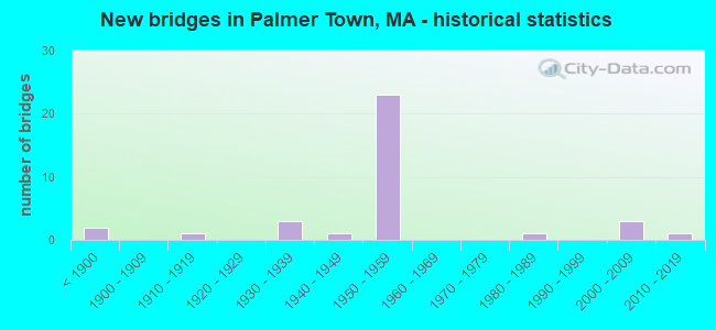
- New bridges - historical statistics
- 2Before 1900
- 11910-1919
- 31930-1939
- 11940-1949
- 231950-1959
- 11980-1989
- 32000-2009
- 12010-2019

- Reconstructed bridges - Historical Statistics
- 11930-1939
- 01940-1949
- 01950-1959
- 01960-1969
- 31970-1979
- 11980-1989
- 41990-1999
- 12000-2009
- 12010-2019


- Bridge Condition - Deck
- 8.7%Very good
- 39.1%Good
- 17.4%Satisfactory
- 21.7%Fair
- 4.3%Poor
- 8.7%Serious

- Bridge Condition - Superstructure
- 8.3%Very good
- 20.8%Good
- 41.7%Satisfactory
- 16.7%Fair
- 12.5%Poor

- Bridge Condition - Substructure
- 8.3%Very good
- 16.7%Good
- 58.3%Satisfactory
- 16.7%Fair

- Bridge Condition - Channel
- 20.0%Very good
- 40.0%Good
- 33.3%Satisfactory
- 6.7%Fair
Find on map >> Show street view
Structure Number: B050055W7MUNNBI, Location: 0.5M W OF RT181 NEAR PLMR (Lat: 42.210111, Lng: -72.365003), Route carried "on" structure: City street , Year Built: 2009, Status: Open, Structure Length: 2.37m (7.78ft), Average Daily Traffic: 1,000 (year 2006), Average Future Daily Traffic: 1,579 (year 2032), Design Load: HS 25 or greater, Features Intersected: WATER JABISH BROOK, Facility Carried by Structure: HWY SOUTH ST
Minimum Vertical Clearance: 30+ m (98+ ft), Kilometerpoint: 0.000, Lanes on structure: 2, Owner: Town or Township Highway Agency, Approaching Roadway Width: 8.3m (27.2ft), Skew: 4 degrees, Material/Design: Prestressed concrete, Design/Construction: Box Beam or Girders - Multiple, Number Of Spans In Main Unit: 1, Length of Maximum Span: 23.0m (75.5ft), Curb or Sidewalk Widths: Left: 0.0m, Right: 1.8m (5.9ft), Curb-To-Curb Width: 8.3m (27.2ft), Out-to-Out Width: 11.0m (36.1ft)
Condition: Deck: Good, Superstructure: Good, Substructure: Good, Channel: Good, Operating Rating: 79.7 metric tons, Method Used To Determine Operating Rating: Load Factor (LF), Inventory Rating: 59.4 metric tons, Method Used To Determine Inventory Rating: Load Factor (LF), Structural Evaluation: Better than present minimum criteria, Deck Geometry: Somewhat better than minimum adequacy, Waterway Adequacy: Superior to present desirable criteria, Approach Roadway Alignment: Equal to present minimum criteria, Length Of Structure Improvement: 2.40m (7.87ft), Designated Inspection Frequency: Every 24 months, Inspection Date: May 2021, Bridge Improvement Cost: $883,000, Roadway Improvement Cost: $89,000, Total Project Cost: $1,325,000 ( Estimate for 2022), Deck Structure Type: Concrete Cast-file-Place, Wearing Surface/Protective System: Wearing Surface: Bituminous, Membrane: Preformed Fabric, Deck Protection: Epoxy Coated Reinforcing
Find on map >> Show street view
Structure Number: B050060PEMUNNBI, Location: 0.5M W OF RT181 NEAR PLMR (Lat: 42.216467, Lng: -72.366325), Route carried "on" structure: City street , Year Built: 1940, Status: Posted for load, Structure Length: 1.25m (4.10ft), Average Daily Traffic: 1,164 (year 2021), Truck Traffic: 5%, Average Future Daily Traffic: 1,224 (year 2032), Features Intersected: WATER JABISH BROOK, Facility Carried by Structure: HWY BARDWELL ST
Minimum Vertical Clearance: 30+ m (98+ ft), Kilometerpoint: 0.756, Lanes on structure: 1, Owner: Town or Township Highway Agency, Approaching Roadway Width: 5.5m (18.0ft), Skew: 3 degrees, Material/Design: Steel, Design/Construction: Stringer/Multi-beam, Number Of Spans In Main Unit: 1, Length of Maximum Span: 11.3m (37.1ft), Curb or Sidewalk Widths: Left: 0.6m (2.0ft), Right: 0.6m (2.0ft), Curb-To-Curb Width: 4.3m (14.1ft), Out-to-Out Width: 5.5m (18.0ft)
Condition: Deck: Satisfactory, Superstructure: Poor, Substructure: Satisfactory, Channel: Satisfactory, Operating Rating: 32.3 metric tons, Method Used To Determine Operating Rating: Load Factor (LF), Inventory Rating: 19.3 metric tons, Method Used To Determine Inventory Rating: Load Factor (LF), Structural Evaluation: Meets minimum limits, Deck Geometry: High priority of replacement, Waterway Adequacy: Better than present minimum criteria, Approach Roadway Alignment: Somewhat better than minimum adequacy, Bridge Posting: Required (Relationship of Operating Rating to Maximum Legal Load: 0.1 - 9.9% below), Length Of Structure Improvement: 2.00m (6.56ft), Designated Inspection Frequency: Every 12 months, Underwater Inspection Frequency: Every 36 months, Other Special Inspection Frequency: Every 12 months, Inspection Date: October 2021, Underwater Inspection Date: January 2022, Other Special Inspection Date: October 2021, Bridge Improvement Cost: $1,530,000, Roadway Improvement Cost: $154,000, Total Project Cost: $2,296,000 ( Estimate for 2022), Deck Structure Type: Concrete Cast-file-Place, Wearing Surface/Protective System: Wearing Surface: Bituminous
Find on map >> Show street view
Structure Number: B05025AN1MUNNBI, Location: @ RIVER RD AND WARE LINE (Lat: 42.243211, Lng: -72.334828), Route carried "on" structure: City street , Year Built: 2004, Status: Open, Structure Length: 3.15m (10.33ft), Average Daily Traffic: 259 (year 2018), Truck Traffic: 1%, Average Future Daily Traffic: 616 (year 2031), Design Load: HS 25 or greater, Features Intersected: WATER SWIFT RIVER, Facility Carried by Structure: HWY COLD SPRG RD
Minimum Vertical Clearance: 30+ m (98+ ft), Kilometerpoint: 0.016, Lanes on structure: 2, Owner: Town or Township Highway Agency, Approaching Roadway Width: 6.0m (19.7ft), Material/Design: Prestressed concrete, Design/Construction: Box Beam or Girders - Multiple, Number Of Spans In Main Unit: 1, Length of Maximum Span: 30.5m (100.1ft), Curb or Sidewalk Widths: Left: 0.0m, Right: 1.5m (4.9ft), Curb-To-Curb Width: 6.0m (19.7ft), Out-to-Out Width: 8.4m (27.6ft)
Condition: Deck: Good, Superstructure: Good, Substructure: Very good, Channel: Very good, Inventory Rating: 67.2 metric tons, Method Used To Determine Inventory Rating: Load Factor (LF), Structural Evaluation: Better than present minimum criteria, Deck Geometry: High priority of corrective action, Waterway Adequacy: Better than present minimum criteria, Approach Roadway Alignment: Equal to present desirable criteria, Length Of Structure Improvement: 3.20m (10.50ft), Designated Inspection Frequency: Every 24 months, Inspection Date: October 2020, Bridge Improvement Cost: $1,509,000, Roadway Improvement Cost: $151,000, Total Project Cost: $2,264,000 ( Estimate for 2022), Deck Structure Type: Concrete Precast Panels, Wearing Surface/Protective System: Wearing Surface: Bituminous, Membrane: Preformed Fabric, Deck Protection: Epoxy Coated Reinforcing
Find on map >> Show street view
Structure Number: P0101717DMUNNBI, Location: 300' N OF RIVER ST INT (Lat: 42.185494, Lng: -72.324644), Route carried "on" structure: City street , Year Built: 1937, Status: Closed, Structure Length: 3.68m (12.07ft), Average Daily Traffic: 6,364 (year 2018), Truck Traffic: 10%, Average Future Daily Traffic: 6,949 (year 2031), Design Load: H 15, Features Intersected: WATER WARE RIVER, Facility Carried by Structure: HWY CHURCH ST
Minimum Vertical Clearance: 30+ m (98+ ft), Kilometerpoint: 0.885, Lanes on structure: 2, Owner: Town or Township Highway Agency, Approaching Roadway Width: 7.3m (24.0ft), Material/Design: Concrete continuous, Design/Construction: Tee Beam, Number Of Spans In Main Unit: 3, Length of Maximum Span: 14.6m (47.9ft), Curb or Sidewalk Widths: Left: 1.5m (4.9ft), Right: 1.5m (4.9ft), Curb-To-Curb Width: 7.3m (24.0ft), Out-to-Out Width: 11.9m (39.0ft)
Condition: Deck: Serious, Superstructure: Poor, Substructure: Fair, Channel: Fair, Waterway Adequacy: Better than present minimum criteria, Approach Roadway Alignment: Equal to present minimum criteria, Bridge Posting: Required (Relationship of Operating Rating to Maximum Legal Load: > 39.9% below), Length Of Structure Improvement: 4.70m (15.42ft), Designated Inspection Frequency: Every 12 months, Inspection Date: April 2020, Bridge Improvement Cost: $4,432,000, Roadway Improvement Cost: $444,000, Total Project Cost: $6,649,000 ( Estimate for 2022), Deck Structure Type: Concrete Cast-file-Place, Wearing Surface/Protective System: Wearing Surface: Bituminous
Find on map >> Show street view
Structure Number: P01018B5EMUNNBI, Location: 200' E OF EMERY ST (Lat: 42.204556, Lng: -72.318667), Route carried "on" structure: City street , Year Built: 2011, Status: Open, Structure Length: 3.36m (11.02ft), Average Daily Traffic: 4,397 (year 2019), Average Future Daily Traffic: 2,246 (year 2032), Design Load: HL 93, Features Intersected: WATER WARE RIVER, Facility Carried by Structure: HWY STATE ST
Minimum Vertical Clearance: 30+ m (98+ ft), Kilometerpoint: 2.205, Lanes on structure: 2, Owner: Town or Township Highway Agency, Approaching Roadway Width: 7.9m (25.9ft), Material/Design: Prestressed concrete, Design/Construction: Box Beam or Girders - Single/Spread, Number Of Spans In Main Unit: 2, Length of Maximum Span: 16.2m (53.1ft), Curb or Sidewalk Widths: Left: 0.0m, Right: 1.8m (5.9ft), Curb-To-Curb Width: 7.9m (25.9ft), Out-to-Out Width: 10.7m (35.1ft)
Condition: Deck: Very good, Superstructure: Very good, Substructure: Very good, Channel: Very good, Operating Rating: 48.6 metric tons, Method Used To Determine Operating Rating: Load and Resistance Factor Rating (LRFR) rating reported by rating factor(RF) method using HL-93 loadings, Inventory Rating: 38.9 metric tons, Method Used To Determine Inventory Rating: Load and Resistance Factor Rating (LRFR) rating reported by rating factor(RF) method using HL-93 loadings, Structural Evaluation: Equal to present desirable criteria, Deck Geometry: High priority of corrective action, Waterway Adequacy: Equal to present desirable criteria, Approach Roadway Alignment: Equal to present desirable criteria, Length Of Structure Improvement: 3.40m (11.15ft), Designated Inspection Frequency: Every 24 months, Underwater Inspection Frequency: Every 36 months, Inspection Date: November 2021, Underwater Inspection Date: December 2020, Bridge Improvement Cost: $1,764,000, Roadway Improvement Cost: $177,000, Total Project Cost: $2,647,000 ( Estimate for 2022), Deck Structure Type: Concrete Cast-file-Place, Wearing Surface/Protective System: Wearing Surface: Bituminous, Membrane: Preformed Fabric, Deck Protection: Epoxy Coated Reinforcing
Find on map >> Show street view
Structure Number: P0102118UDOTNBI, Location: .3 M W OF INT W N.MAIN ST (Lat: 42.161447, Lng: -72.348994), Route carried "on" structure: US 20, Year Built: 1910, Year Reconstructed: 1930, Status: Open, Structure Length: 3.06m (10.04ft), Average Daily Traffic: 13,981 (year 2019), Truck Traffic: 1%, Average Future Daily Traffic: 14,296 (year 2032), Features Intersected: WATER QUABOAG RIVER
Minimum Vertical Clearance: 30+ m (98+ ft), Kilometerpoint: 125.418, Lanes on structure: 2, Base Highway Network: Yes, Owner: State Highway Agency, Approaching Roadway Width: 12.2m (40.0ft), Material/Design: Masonry, Design/Construction: Arch - Deck, Number Of Spans In Main Unit: 3, Length of Maximum Span: 15.1m (49.5ft), Curb or Sidewalk Widths: Left: 2.1m (6.9ft), Right: 1.8m (5.9ft), Curb-To-Curb Width: 12.2m (40.0ft), Out-to-Out Width: 17.2m (56.4ft)
Condition: Superstructure: Satisfactory, Substructure: Satisfactory, Channel: Satisfactory, Structural Evaluation: Equal to present minimum criteria, Deck Geometry: Somewhat better than minimum adequacy, Waterway Adequacy: Equal to present desirable criteria, Approach Roadway Alignment: Equal to present desirable criteria, Length Of Structure Improvement: 3.10m (10.17ft), Designated Inspection Frequency: Every 24 months, Inspection Date: October 2021, Bridge Improvement Cost: $351,000, Roadway Improvement Cost: $36,000, Total Project Cost: $527,000 ( Estimate for 2022)
Find on map >> Show street view
Structure Number: P010248G4DOTNBI, Location: AT JCT OF ST 67 & US 20 (Lat: 42.143667, Lng: -72.284083), Route carried "on" structure: US 20, Year Built: 2008, Status: Open, Structure Length: 5.30m (17.39ft), Average Daily Traffic: 15,000 (year 2014), Truck Traffic: 15%, Design Load: HS 25 or greater, Features Intersected: COMB ST67 NB & CSX
Minimum Vertical Clearance: 30+ m (98+ ft), Kilometerpoint: 131.882, Lanes on structure: 2, Lanes under structure: 2, Base Highway Network: Yes, Owner: State Highway Agency, Approaching Roadway Width: 13.5m (44.3ft), Skew: 5 degrees, Material/Design: Steel continuous, Design/Construction: Stringer/Multi-beam, Number Of Spans In Main Unit: 2, Length of Maximum Span: 27.8m (91.2ft), Curb or Sidewalk Widths: Left: 2.0m (6.6ft), Right: 0.0m, Curb-To-Curb Width: 13.5m (44.3ft), Out-to-Out Width: 16.3m (53.5ft)
Condition: Deck: Good, Superstructure: Good, Substructure: Good, Inventory Rating: 78.7 metric tons, Method Used To Determine Inventory Rating: Load Factor (LF), Structural Evaluation: Better than present minimum criteria, Deck Geometry: Superior to present desirable criteria, Underclear: Better than present minimum criteria, Approach Roadway Alignment: Equal to present minimum criteria, Designated Inspection Frequency: Every 24 months, Inspection Date: January 2022, Deck Structure Type: Concrete Cast-file-Place, Wearing Surface/Protective System: Wearing Surface: Bituminous, Membrane: Preformed Fabric, Deck Protection: Epoxy Coated Reinforcing
Find on map >> Show street view
Structure Number: P010341A8DOTNBI, Location: 0.6 MI S OF I-90 (Lat: 42.161639, Lng: -72.268550), Route carried "on" structure: State highway 67, Year Built: 1955, Status: Open, Structure Length: 0.70m (2.30ft), Average Daily Traffic: 2,845 (year 2020), Truck Traffic: 18%, Average Future Daily Traffic: 4,738 (year 2033), Design Load: H 20, Features Intersected: WATER KINGS BROOK
Minimum Vertical Clearance: 30+ m (98+ ft), Kilometerpoint: 2.839, Lanes on structure: 2, Owner: State Highway Agency, Approaching Roadway Width: 13.4m (44.0ft), Material/Design: Concrete, Design/Construction: Slab, Number Of Spans In Main Unit: 1, Length of Maximum Span: 6.7m (22.0ft), Curb or Sidewalk Widths: Left: 0.3m (1.0ft), Right: 0.3m (1.0ft), Curb-To-Curb Width: 13.4m (44.0ft), Out-to-Out Width: 14.8m (48.6ft)
Condition: Deck: Satisfactory, Superstructure: Satisfactory, Substructure: Satisfactory, Channel: Good, Operating Rating: 48.6 metric tons, Method Used To Determine Operating Rating: Allowable Stress (AS), Inventory Rating: 29.9 metric tons, Method Used To Determine Inventory Rating: Allowable Stress (AS), Structural Evaluation: Equal to present minimum criteria, Deck Geometry: Better than present minimum criteria, Waterway Adequacy: Better than present minimum criteria, Approach Roadway Alignment: Meets minimum limits, Length Of Structure Improvement: 0.80m (2.62ft), Designated Inspection Frequency: Every 24 months, Inspection Date: January 2022, Bridge Improvement Cost: $466,000, Roadway Improvement Cost: $47,000, Total Project Cost: $700,000 ( Estimate for 2022), Deck Structure Type: Concrete Cast-file-Place, Wearing Surface/Protective System: Wearing Surface: Bituminous
Find on map >> Show street view
Structure Number: P010444MQDOTNBI, Location: MM 60.7 ON I-90 (Lat: 42.159647, Lng: -72.363850), Route carried "on" structure: City street , Year Built: 1957, Year Reconstructed: 1995, Status: Open, Structure Length: 5.39m (17.68ft), Average Daily Traffic: 100 (year 2018), Truck Traffic: 5%, Average Future Daily Traffic: 632 (year 2031), Design Load: HS 20, Features Intersected: I 90, Facility Carried by Structure: HWY BPTST HLL RD
Minimum Vertical Clearance: 30+ m (98+ ft), Kilometerpoint: 97.685, Lanes on structure: 2, Lanes under structure: 4, Owner: State Highway Agency, Approaching Roadway Width: 7.3m (24.0ft), Skew: 1 degrees, Material/Design: Steel continuous, Design/Construction: Stringer/Multi-beam, Number Of Spans In Main Unit: 4, Length of Maximum Span: 15.8m (51.8ft), Curb or Sidewalk Widths: Left: 0.8m (2.6ft), Right: 0.8m (2.6ft), Curb-To-Curb Width: 7.3m (24.0ft), Out-to-Out Width: 9.8m (32.2ft)
Condition: Deck: Good, Superstructure: Good, Substructure: Satisfactory, Operating Rating: 70.6 metric tons, Method Used To Determine Operating Rating: Load Factor (LF), Inventory Rating: 42.3 metric tons, Method Used To Determine Inventory Rating: Load Factor (LF), Structural Evaluation: Equal to present minimum criteria, Deck Geometry: Equal to present minimum criteria, Underclear: High priority of corrective action, Approach Roadway Alignment: Equal to present desirable criteria, Length Of Structure Improvement: 5.40m (17.72ft), Designated Inspection Frequency: Every 24 months, Inspection Date: May 2020, Bridge Improvement Cost: $1,273,000, Roadway Improvement Cost: $128,000, Total Project Cost: $1,910,000 ( Estimate for 2022), Deck Structure Type: Concrete Cast-file-Place, Wearing Surface/Protective System: Wearing Surface: Bituminous, Membrane: Built-up, Deck Protection: Epoxy Coated Reinforcing
Find on map >> Show street view
Structure Number: P010454MPDOTNBI, Location: MM 61.5 ON I90 (Lat: 42.167517, Lng: -72.353381), Route carried "on" structure: Interstate 90, Year Built: 1957, Year Reconstructed: 1995, Status: Open, Structure Length: 6.54m (21.46ft), Average Daily Traffic: 400 (year 1997), Truck Traffic: 5%, Average Future Daily Traffic: 632 (year 2032), Design Load: HS 20, Features Intersected: I 90, Facility Carried by Structure: HWY CALKINS RD
Minimum Vertical Clearance: 4.24m (13.91ft), Kilometerpoint: 98.811, Lanes on structure: 2, Lanes under structure: 4, Owner: State Highway Agency, Approaching Roadway Width: 7.3m (24.0ft), Skew: 4 degrees, Material/Design: Steel continuous, Design/Construction: Stringer/Multi-beam, Number Of Spans In Main Unit: 4, Length of Maximum Span: 20.5m (67.3ft), Curb or Sidewalk Widths: Left: 0.8m (2.6ft), Right: 0.8m (2.6ft), Curb-To-Curb Width: 7.3m (24.0ft), Out-to-Out Width: 9.8m (32.2ft)
Condition: Deck: Satisfactory, Superstructure: Satisfactory, Substructure: Satisfactory, Operating Rating: 83.1 metric tons, Method Used To Determine Operating Rating: Load Factor (LF), Inventory Rating: 49.8 metric tons, Method Used To Determine Inventory Rating: Load Factor (LF), Structural Evaluation: Equal to present minimum criteria, Deck Geometry: Somewhat better than minimum adequacy, Underclear: High priority of corrective action, Approach Roadway Alignment: Equal to present desirable criteria, Length Of Structure Improvement: 6.60m (21.65ft), Designated Inspection Frequency: Every 24 months, Inspection Date: March 2021, Bridge Improvement Cost: $2,303,000, Roadway Improvement Cost: $231,000, Total Project Cost: $3,455,000 ( Estimate for 2022), Deck Structure Type: Concrete Cast-file-Place, Wearing Surface/Protective System: Wearing Surface: Bituminous, Membrane: Preformed Fabric, Deck Protection: Epoxy Coated Reinforcing
Find on map >> Show street view
Structure Number: P010464MMDOTNBI, Location: MM 61.8 ON I-90 EB (Lat: 42.169731, Lng: -72.348550), Route carried "on" structure: Interstate 90, Year Built: 1957, Year Reconstructed: 1992, Status: Open, Structure Length: 14.78m (48.49ft), Average Daily Traffic: 31,587 (year 2017), Truck Traffic: 12%, Average Future Daily Traffic: 53,745 (year 2032), Design Load: HS 20+Mod, Features Intersected: WATER QUABOAG RIVER
Minimum Vertical Clearance: 30+ m (98+ ft), Kilometerpoint: 99.455, Lanes on structure: 2, Base Highway Network: Yes, Toll: On toll road, Owner: State Highway Agency, Approaching Roadway Width: 11.6m (38.1ft), Skew: 5 degrees, Material/Design: Steel continuous, Design/Construction: Stringer/Multi-beam, Number Of Spans In Main Unit: 6, Length of Maximum Span: 27.4m (89.9ft), Curb-To-Curb Width: 12.5m (41.0ft), Out-to-Out Width: 13.6m (44.6ft)
Condition: Deck: Good, Superstructure: Satisfactory, Substructure: Satisfactory, Channel: Satisfactory, Operating Rating: 57.8 metric tons, Method Used To Determine Operating Rating: Load Factor (LF), Inventory Rating: 34.6 metric tons, Method Used To Determine Inventory Rating: Load Factor (LF), Structural Evaluation: Equal to present minimum criteria, Deck Geometry: Better than present minimum criteria, Approach Roadway Alignment: Equal to present desirable criteria, Length Of Structure Improvement: 14.80m (48.56ft), Designated Inspection Frequency: Every 24 months, Underwater Inspection Frequency: Every 36 months, Inspection Date: April 2021, Underwater Inspection Date: October 2021, Bridge Improvement Cost: $419,000, Roadway Improvement Cost: $42,000, Total Project Cost: $629,000 ( Estimate for 2022), Deck Structure Type: Concrete Cast-file-Place, Wearing Surface/Protective System: Wearing Surface: Bituminous, Membrane: Preformed Fabric, Deck Protection: Epoxy Coated Reinforcing
Find on map >> Show street view
Structure Number: P010524MEDOTNBI, Location: MM 63.3 ON I-90 WB (Lat: 42.176808, Lng: -72.319675), Route carried "on" structure: Interstate 90, Year Built: 1957, Year Reconstructed: 1984, Status: Temporarily open, Structure Length: 6.00m (19.69ft), Average Daily Traffic: 23,842 (year 2017), Truck Traffic: 15%, Average Future Daily Traffic: 53,745 (year 2032), Design Load: HS 20, Features Intersected: ST 32 THORNDIKE ST
Minimum Vertical Clearance: 30+ m (98+ ft), Kilometerpoint: 101.869, Lanes on structure: 2, Lanes under structure: 2, Base Highway Network: Yes, Toll: On toll road, Owner: State Highway Agency, Approaching Roadway Width: 12.5m (41.0ft), Skew: 3 degrees, Material/Design: Steel, Design/Construction: Stringer/Multi-beam, Number Of Spans In Main Unit: 3, Number Of Approach Spans: 2, Length of Maximum Span: 21.5m (70.5ft), Curb-To-Curb Width: 12.5m (41.0ft), Out-to-Out Width: 13.9m (45.6ft)
Condition: Deck: Fair, Superstructure: Fair, Substructure: Satisfactory, Operating Rating: 32.9 metric tons, Method Used To Determine Operating Rating: Load Factor (LF), Inventory Rating: 19.7 metric tons, Method Used To Determine Inventory Rating: Load Factor (LF), Structural Evaluation: Meets minimum limits, Deck Geometry: Better than present minimum criteria, Underclear: High priority of corrective action, Approach Roadway Alignment: Equal to present desirable criteria, Length Of Structure Improvement: 6.10m (20.01ft), Designated Inspection Frequency: Every 24 months, Inspection Date: April 2020, Bridge Improvement Cost: $3,331,000, Roadway Improvement Cost: $334,000, Total Project Cost: $4,997,000 ( Estimate for 2022), Deck Structure Type: Concrete Cast-file-Place, Wearing Surface/Protective System: Wearing Surface: Bituminous, Membrane: Preformed Fabric, Deck Protection: Epoxy Coated Reinforcing
Find on map >> Show street view
Structure Number: P010534MCDOTNBI, Location: MM 63.6 ON I-90 (Lat: 42.177281, Lng: -72.316014), Route carried "on" structure: Interstate 90, Year Built: 1957, Status: Posted for load, Structure Length: 4.99m (16.37ft), Average Daily Traffic: 5,172 (year 2020), Truck Traffic: 5%, Average Future Daily Traffic: 632 (year 2033), Design Load: H 15, Features Intersected: I 90, Facility Carried by Structure: HWY BRCKNRDGE ST
Minimum Vertical Clearance: 30+ m (98+ ft), Kilometerpoint: 102.191, Lanes on structure: 2, Lanes under structure: 4, Owner: State Highway Agency, Approaching Roadway Width: 9.1m (29.9ft), Material/Design: Steel, Design/Construction: Stringer/Multi-beam, Number Of Spans In Main Unit: 2, Length of Maximum Span: 24.3m (79.7ft), Curb or Sidewalk Widths: Left: 0.8m (2.6ft), Right: 0.8m (2.6ft), Curb-To-Curb Width: 9.1m (29.9ft), Out-to-Out Width: 11.6m (38.1ft)
Condition: Deck: Fair, Superstructure: Satisfactory, Substructure: Satisfactory, Operating Rating: 38.7 metric tons, Method Used To Determine Operating Rating: Load Factor (LF), Inventory Rating: 23.2 metric tons, Method Used To Determine Inventory Rating: Load Factor (LF), Structural Evaluation: Somewhat better than minimum adequacy, Deck Geometry: High priority of corrective action, Underclear: High priority of corrective action, Approach Roadway Alignment: Equal to present desirable criteria, Length Of Structure Improvement: 5.00m (16.40ft), Designated Inspection Frequency: Every 24 months, Inspection Date: November 2021, Bridge Improvement Cost: $2,279,000, Roadway Improvement Cost: $228,000, Total Project Cost: $3,419,000 ( Estimate for 2022), Deck Structure Type: Concrete Cast-file-Place, Wearing Surface/Protective System: Wearing Surface: Bituminous, Membrane: Built-up
Find on map >> Show street view
Structure Number: P010544MBDOTNBI, Location: MM 64.5 ON I-90 (Lat: 42.170519, Lng: -72.299664), Route carried "on" structure: City street , Year Built: 1957, Status: Open, Structure Length: 6.03m (19.78ft), Average Daily Traffic: 1,422 (year 2019), Truck Traffic: 9%, Average Future Daily Traffic: 632 (year 2031), Design Load: HS 20, Features Intersected: I 90, Facility Carried by Structure: HWY FLYNT ST
Minimum Vertical Clearance: 30+ m (98+ ft), Kilometerpoint: 103.800, Lanes on structure: 2, Lanes under structure: 4, Owner: State Highway Agency, Approaching Roadway Width: 7.3m (24.0ft), Skew: 2 degrees, Material/Design: Steel, Design/Construction: Stringer/Multi-beam, Number Of Spans In Main Unit: 4, Length of Maximum Span: 16.6m (54.5ft), Curb or Sidewalk Widths: Left: 0.8m (2.6ft), Right: 0.8m (2.6ft), Curb-To-Curb Width: 7.3m (24.0ft), Out-to-Out Width: 9.8m (32.2ft)
Condition: Deck: Poor, Superstructure: Fair, Substructure: Fair, Operating Rating: 42.1 metric tons, Method Used To Determine Operating Rating: Load Factor (LF), Inventory Rating: 25.3 metric tons, Method Used To Determine Inventory Rating: Load Factor (LF), Structural Evaluation: Somewhat better than minimum adequacy, Deck Geometry: Meets minimum limits, Underclear: High priority of corrective action, Approach Roadway Alignment: Equal to present desirable criteria, Length Of Structure Improvement: 6.10m (20.01ft), Designated Inspection Frequency: Every 12 months, Other Special Inspection Frequency: Every 12 months, Inspection Date: May 2020, Other Special Inspection Date: May 2021, Bridge Improvement Cost: $2,349,000, Roadway Improvement Cost: $235,000, Total Project Cost: $3,524,000 ( Estimate for 2022), Deck Structure Type: Concrete Cast-file-Place, Wearing Surface/Protective System: Wearing Surface: Monolithic Concrete
Find on map >> Show street view
Structure Number: P010554M9DOTNBI, Location: MM 66.5 ON I-90 EB (Lat: 42.169972, Lng: -72.264494), Route carried "on" structure: Interstate 90, Year Built: 1957, Year Reconstructed: 1984, Status: Open, Structure Length: 6.54m (21.46ft), Average Daily Traffic: 24,667 (year 2019), Truck Traffic: 10%, Average Future Daily Traffic: 53,745 (year 2033), Design Load: HS 20+Mod, Features Intersected: ST 67 BOSTON RD
Minimum Vertical Clearance: 30+ m (98+ ft), Kilometerpoint: 107.018, Lanes on structure: 2, Lanes under structure: 2, Base Highway Network: Yes, Toll: On toll road, Owner: State Highway Agency, Approaching Roadway Width: 12.2m (40.0ft), Skew: 14 degrees, Material/Design: Steel, Design/Construction: Stringer/Multi-beam, Number Of Spans In Main Unit: 3, Length of Maximum Span: 23.8m (78.1ft), Curb-To-Curb Width: 12.2m (40.0ft), Out-to-Out Width: 13.6m (44.6ft)
Condition: Deck: Fair, Superstructure: Poor, Substructure: Satisfactory, Operating Rating: 61.5 metric tons, Method Used To Determine Operating Rating: Load Factor (LF), Inventory Rating: 36.8 metric tons, Method Used To Determine Inventory Rating: Load Factor (LF), Structural Evaluation: Meets minimum limits, Deck Geometry: Better than present minimum criteria, Underclear: High priority of corrective action, Approach Roadway Alignment: Equal to present desirable criteria, Length Of Structure Improvement: 6.60m (21.65ft), Designated Inspection Frequency: Every 12 months, Other Special Inspection Frequency: Every 12 months, Inspection Date: March 2020, Other Special Inspection Date: March 2021, Bridge Improvement Cost: $3,526,000, Roadway Improvement Cost: $353,000, Total Project Cost: $5,290,000 ( Estimate for 2022), Deck Structure Type: Concrete Cast-file-Place, Wearing Surface/Protective System: Wearing Surface: Bituminous, Membrane: Preformed Fabric, Deck Protection: Epoxy Coated Reinforcing
Find on map >> Show street view
Structure Number: P010554MADOTNBI, Location: MM 66.5 ON I-90 WB (Lat: 42.170186, Lng: -72.264428), Route carried "on" structure: Interstate 90, Year Built: 1957, Year Reconstructed: 1984, Status: Open, Structure Length: 6.54m (21.46ft), Average Daily Traffic: 24,514 (year 2019), Truck Traffic: 10%, Average Future Daily Traffic: 53,745 (year 2033), Design Load: HS 20+Mod, Features Intersected: ST 67 BOSTON RD
Minimum Vertical Clearance: 30+ m (98+ ft), Kilometerpoint: 107.018, Lanes on structure: 2, Lanes under structure: 2, Base Highway Network: Yes, Toll: On toll road, Owner: State Highway Agency, Approaching Roadway Width: 12.2m (40.0ft), Skew: 14 degrees, Material/Design: Steel, Design/Construction: Stringer/Multi-beam, Number Of Spans In Main Unit: 3, Length of Maximum Span: 23.8m (78.1ft), Curb-To-Curb Width: 12.2m (40.0ft), Out-to-Out Width: 13.6m (44.6ft)
Condition: Deck: Fair, Superstructure: Fair, Substructure: Satisfactory, Operating Rating: 60.9 metric tons, Method Used To Determine Operating Rating: Load Factor (LF), Inventory Rating: 36.4 metric tons, Method Used To Determine Inventory Rating: Load Factor (LF), Structural Evaluation: Somewhat better than minimum adequacy, Deck Geometry: Better than present minimum criteria, Underclear: High priority of corrective action, Approach Roadway Alignment: Equal to present desirable criteria, Length Of Structure Improvement: 6.60m (21.65ft), Designated Inspection Frequency: Every 24 months, Inspection Date: March 2020, Bridge Improvement Cost: $3,526,000, Roadway Improvement Cost: $353,000, Total Project Cost: $5,290,000 ( Estimate for 2022), Deck Structure Type: Concrete Cast-file-Place, Wearing Surface/Protective System: Wearing Surface: Bituminous, Membrane: Preformed Fabric, Deck Protection: Epoxy Coated Reinforcing
Find on map >> Show street view
Structure Number: W0501512PDOTNBI, Location: AT JCT OLD BELCHERTWN RD. (Lat: 42.238747, Lng: -72.285869), Route carried "on" structure: State highway 32, Year Built: 1937, Status: Posted for load, Structure Length: 4.72m (15.49ft), Average Daily Traffic: 12,634 (year 2019), Truck Traffic: 5%, Average Future Daily Traffic: 21,321 (year 2031), Design Load: H 20, Features Intersected: WATER WARE RIVER
Minimum Vertical Clearance: 30+ m (98+ ft), Kilometerpoint: 27.358, Lanes on structure: 2, Base Highway Network: Yes, Owner: State Highway Agency, Approaching Roadway Width: 9.1m (29.9ft), Skew: 2 degrees, Material/Design: Steel continuous, Design/Construction: Stringer/Multi-beam, Number Of Spans In Main Unit: 3, Length of Maximum Span: 25.6m (84.0ft), Curb or Sidewalk Widths: Left: 0.3m (1.0ft), Right: 2.0m (6.6ft), Curb-To-Curb Width: 9.1m (29.9ft), Out-to-Out Width: 12.2m (40.0ft)
Condition: Deck: Serious, Superstructure: Satisfactory, Substructure: Fair, Channel: Good, Operating Rating: 36.9 metric tons, Method Used To Determine Operating Rating: Load Factor (LF), Inventory Rating: 22.1 metric tons, Method Used To Determine Inventory Rating: Load Factor (LF), Structural Evaluation: Somewhat better than minimum adequacy, Deck Geometry: High priority of corrective action, Waterway Adequacy: Equal to present desirable criteria, Approach Roadway Alignment: Equal to present desirable criteria, Length Of Structure Improvement: 4.80m (15.75ft), Designated Inspection Frequency: Every 6 months, Underwater Inspection Frequency: Every 36 months, Other Special Inspection Frequency: Every 6 months, Inspection Date: September 2020, Underwater Inspection Date: August 2021, Other Special Inspection Date: March 2022, Bridge Improvement Cost: $2,301,000, Roadway Improvement Cost: $231,000, Total Project Cost: $3,452,000 ( Estimate for 2022), Deck Structure Type: Concrete Cast-file-Place, Wearing Surface/Protective System: Wearing Surface: Bituminous, Membrane: Built-up
Find on map >> Show street view
Structure Number: W050240T4MUNNBI, Location: 1.5 M W OF RT32 NEAR PLMR (Lat: 42.241278, Lng: -72.305111), Route carried "on" structure: City street , Year Built: 1938, Status: Open, Structure Length: 0.77m (2.53ft), Average Daily Traffic: 905 (year 2021), Truck Traffic: 6%, Average Future Daily Traffic: 2,451 (year 2032), Design Load: H 20, Features Intersected: WATER BEAVER BROOK, Facility Carried by Structure: HWY OLD BLCHRTN
Minimum Vertical Clearance: 30+ m (98+ ft), Kilometerpoint: 3.025, Lanes on structure: 2, Owner: Town or Township Highway Agency, Approaching Roadway Width: 6.1m (20.0ft), Material/Design: Steel, Design/Construction: Stringer/Multi-beam, Number Of Spans In Main Unit: 1, Length of Maximum Span: 6.6m (21.7ft), Curb or Sidewalk Widths: Left: 0.1m (0.3ft), Right: 0.1m (0.3ft), Curb-To-Curb Width: 6.1m (20.0ft), Out-to-Out Width: 7.3m (24.0ft)
Condition: Deck: Good, Superstructure: Satisfactory, Substructure: Good, Channel: Good, Operating Rating: 60.1 metric tons, Method Used To Determine Operating Rating: Load Factor (LF), Inventory Rating: 36.0 metric tons, Method Used To Determine Inventory Rating: Load Factor (LF), Structural Evaluation: Equal to present minimum criteria, Deck Geometry: High priority of corrective action, Waterway Adequacy: Better than present minimum criteria, Approach Roadway Alignment: Better than present minimum criteria, Length Of Structure Improvement: 0.80m (2.62ft), Designated Inspection Frequency: Every 24 months, Inspection Date: August 2021, Bridge Improvement Cost: $461,000, Roadway Improvement Cost: $47,000, Total Project Cost: $692,000 ( Estimate for 2022), Deck Structure Type: Concrete Cast-file-Place, Wearing Surface/Protective System: Wearing Surface: Bituminous
Find on map >> Show street view
Structure Number: W070041AWDOT634, Location: AT JCT OF ST 67 (Lat: 42.211347, Lng: -72.234617), Route carried "on" structure: City street , Year Built: 1980, Status: Open, Structure Length: 9.14m (29.99ft), Average Daily Traffic: 3,103 (year 2018), Truck Traffic: 6%, Average Future Daily Traffic: 2,451 (year 2033), Design Load: H 20, Features Intersected: COMB QUABOAG R & CSX, Facility Carried by Structure: HWY SOUTH ST
Minimum Vertical Clearance: 30+ m (98+ ft), Kilometerpoint: 0.000, Lanes on structure: 2, Owner: State Highway Agency, Approaching Roadway Width: 7.9m (25.9ft), Skew: 1 degrees, Material/Design: Steel continuous, Design/Construction: Stringer/Multi-beam, Number Of Spans In Main Unit: 4, Length of Maximum Span: 35.4m (116.1ft), Curb or Sidewalk Widths: Left: 0.3m (1.0ft), Right: 1.8m (5.9ft), Curb-To-Curb Width: 7.9m (25.9ft), Out-to-Out Width: 10.8m (35.4ft)
Condition: Deck: Good, Superstructure: Good, Substructure: Fair, Channel: Good, Operating Rating: 35.1 metric tons, Method Used To Determine Operating Rating: Allowable Stress (AS), Inventory Rating: 26.1 metric tons, Method Used To Determine Inventory Rating: Allowable Stress (AS), Structural Evaluation: Somewhat better than minimum adequacy, Deck Geometry: High priority of corrective action, Underclear: High priority of corrective action, Waterway Adequacy: Equal to present desirable criteria, Approach Roadway Alignment: Equal to present desirable criteria, Length Of Structure Improvement: 9.20m (30.18ft), Designated Inspection Frequency: Every 24 months, Inspection Date: March 2020, Bridge Improvement Cost: $3,903,000, Roadway Improvement Cost: $391,000, Total Project Cost: $5,855,000 ( Estimate for 2022), Deck Structure Type: Concrete Cast-file-Place, Wearing Surface/Protective System: Wearing Surface: Monolithic Concrete
Find on map >> Show street view
Structure Number: W0700617XMUNNBI, Location: AT INT W RT67&MAIN ST (Lat: 42.210342, Lng: -72.245447), Route carried "on" structure: City street , Year Built: 1888, Year Reconstructed: 2008, Status: Posted for load, Structure Length: 2.31m (7.58ft), Average Daily Traffic: 260 (year 2018), Truck Traffic: 6%, Average Future Daily Traffic: 411 (year 2031), Design Load: H 15, Features Intersected: WATER QUABOAG RIVER, Facility Carried by Structure: HWY GILBERT RD
Minimum Vertical Clearance: 30+ m (98+ ft), Kilometerpoint: 3.589, Lanes on structure: 1, Owner: Town or Township Highway Agency, Approaching Roadway Width: 4.6m (15.1ft), Material/Design: Aluminum, Iron, Design/Construction: Truss - Thru, Number Of Spans In Main Unit: 1, Length of Maximum Span: 22.0m (72.2ft), Curb-To-Curb Width: 4.7m (15.4ft), Out-to-Out Width: 5.5m (18.0ft)
Condition: Deck: Good, Superstructure: Satisfactory, Substructure: Satisfactory, Channel: Good, Operating Rating: 26.6 metric tons, Method Used To Determine Operating Rating: Load Factor (LF), Inventory Rating: 15.9 metric tons, Method Used To Determine Inventory Rating: Load Factor (LF), Structural Evaluation: Meets minimum limits, Deck Geometry: High priority of replacement, Waterway Adequacy: Better than present minimum criteria, Approach Roadway Alignment: Meets minimum limits, Bridge Posting: Required (Relationship of Operating Rating to Maximum Legal Load: 10.0 - 19.9% below), Length Of Structure Improvement: 3.20m (10.50ft), Designated Inspection Frequency: Every 24 months, Critical Feature Inspection Frequency: Every 24 months, Inspection Date: June 2020, Critical Feature Inspection Date: June 2020, Bridge Improvement Cost: $1,978,000, Roadway Improvement Cost: $198,000, Total Project Cost: $2,968,000 ( Estimate for 2022), Deck Structure Type: Corrugated Steel, Wearing Surface/Protective System: Wearing Surface: Bituminous
Find on map >> Show street view
Structure Number: W070284NCDOTNBI, Location: MM 67.9 ON I-90 (Lat: 42.179683, Lng: -72.241269), Route carried "on" structure: Interstate 90, Year Built: 1957, Year Reconstructed: 1996, Status: Open, Structure Length: 5.66m (18.57ft), Average Daily Traffic: 200 (year 1997), Truck Traffic: 5%, Average Future Daily Traffic: 316 (year 2031), Design Load: H 20, Features Intersected: I 90, Facility Carried by Structure: HWY GILBERT RD
Minimum Vertical Clearance: 30+ m (98+ ft), Kilometerpoint: 109.271, Lanes on structure: 2, Lanes under structure: 4, Owner: State Highway Agency, Approaching Roadway Width: 7.3m (24.0ft), Material/Design: Steel, Design/Construction: Stringer/Multi-beam, Number Of Spans In Main Unit: 4, Length of Maximum Span: 15.2m (49.9ft), Curb or Sidewalk Widths: Left: 0.8m (2.6ft), Right: 0.8m (2.6ft), Curb-To-Curb Width: 7.3m (24.0ft), Out-to-Out Width: 9.8m (32.2ft)
Condition: Deck: Good, Superstructure: Satisfactory, Substructure: Satisfactory, Operating Rating: 44.4 metric tons, Method Used To Determine Operating Rating: Load Factor (LF), Inventory Rating: 26.6 metric tons, Method Used To Determine Inventory Rating: Load Factor (LF), Structural Evaluation: Equal to present minimum criteria, Deck Geometry: Somewhat better than minimum adequacy, Underclear: Equal to present minimum criteria, Approach Roadway Alignment: Equal to present desirable criteria, Length Of Structure Improvement: 5.70m (18.70ft), Designated Inspection Frequency: Every 24 months, Inspection Date: May 2020, Bridge Improvement Cost: $2,195,000, Roadway Improvement Cost: $220,000, Total Project Cost: $3,293,000 ( Estimate for 2022), Deck Structure Type: Concrete Cast-file-Place, Wearing Surface/Protective System: Wearing Surface: Bituminous, Membrane: Built-up, Deck Protection: Epoxy Coated Reinforcing
Find on map >> Show street view
Structure Number: W070314NBDOTNBI, Location: MM 68.2 ON I-90 (Lat: 42.180464, Lng: -72.234903), Route carried "on" structure: Interstate 90, Year Built: 1957, Status: Open, Structure Length: 1.04m (3.41ft), Average Daily Traffic: 47,799 (year 2017), Truck Traffic: 15%, Average Future Daily Traffic: 53,745 (year 2032), Design Load: H 20, Features Intersected: WATER TUFTS BROOK
Minimum Vertical Clearance: 30+ m (98+ ft), Kilometerpoint: 109.754, Lanes on structure: 4, Base Highway Network: Yes, Toll: On toll road, Owner: State Highway Agency, Approaching Roadway Width: 23.2m (76.1ft), Material/Design: Concrete continuous, Design/Construction: Culvert, Number Of Spans In Main Unit: 3, Length of Maximum Span: 3.0m (9.8ft)
Condition: Channel: Satisfactory, Culverts: Satisfactory, Inventory Rating: 64.7 metric tons, Method Used To Determine Inventory Rating: Load Factor (LF), Structural Evaluation: Equal to present minimum criteria, Waterway Adequacy: Equal to present desirable criteria, Approach Roadway Alignment: Better than present minimum criteria, Length Of Structure Improvement: 2.40m (7.87ft), Designated Inspection Frequency: Every 24 months, Inspection Date: April 2020, Bridge Improvement Cost: $197,000, Roadway Improvement Cost: $20,000, Total Project Cost: $296,000 ( Estimate for 2022)
Find on map >> Show street view
Structure Number: W350030P3MUNNBI, Location: 0.2 MI E OF LUDLOW TL (Lat: 42.176856, Lng: -72.408400), Route carried "on" structure: City street , Year Built: 1850, Year Reconstructed: 2010, Status: Open, Structure Length: 2.97m (9.74ft), Average Daily Traffic: 5,043 (year 2014), Truck Traffic: 6%, Average Future Daily Traffic: 4,106 (year 2031), Design Load: HS 25 or greater, Features Intersected: WATER N E UTILITIES CANL, Facility Carried by Structure: HWY RED BRIDG RD
Minimum Vertical Clearance: 30+ m (98+ ft), Kilometerpoint: 0.370, Lanes on structure: 2, Owner: Town or Township Highway Agency, Approaching Roadway Width: 10.5m (34.4ft), Skew: 2 degrees, Material/Design: Steel, Design/Construction: Stringer/Multi-beam, Number Of Spans In Main Unit: 1, Length of Maximum Span: 28.3m (92.8ft), Curb or Sidewalk Widths: Left: 1.5m (4.9ft), Right: 0.0m, Curb-To-Curb Width: 9.8m (32.2ft), Out-to-Out Width: 12.4m (40.7ft)
Condition: Deck: Very good, Superstructure: Very good, Substructure: Good, Channel: Very good, Operating Rating: 82.2 metric tons, Method Used To Determine Operating Rating: Load Factor (LF), Inventory Rating: 49.2 metric tons, Method Used To Determine Inventory Rating: Load Factor (LF), Structural Evaluation: Better than present minimum criteria, Deck Geometry: Meets minimum limits, Waterway Adequacy: Equal to present desirable criteria, Approach Roadway Alignment: Superior to present desirable criteria, Length Of Structure Improvement: 3.00m (9.84ft), Designated Inspection Frequency: Every 24 months, Inspection Date: October 2020, Bridge Improvement Cost: $1,032,000, Roadway Improvement Cost: $104,000, Total Project Cost: $1,549,000 ( Estimate for 2022), Deck Structure Type: Concrete Cast-file-Place, Wearing Surface/Protective System: Wearing Surface: Bituminous, Membrane: Preformed Fabric, Deck Protection: Epoxy Coated Reinforcing
Find on map >> Show street view
Structure Number: W350040TYMUNNBI, Location: 0.3MI S OF RT20 NR I90 (Lat: 42.148028, Lng: -72.399750), Route carried "on" structure: City street , Year Built: 1956, Status: Open, Structure Length: 1.26m (4.13ft), Average Daily Traffic: 776 (year 2020), Truck Traffic: 4%, Average Future Daily Traffic: 616 (year 2033), Design Load: H 15, Features Intersected: WATER TWELVE MILE BROOK, Facility Carried by Structure: HWY CRANE HLL RD
Minimum Vertical Clearance: 30+ m (98+ ft), Kilometerpoint: 4.200, Lanes on structure: 2, Owner: Town or Township Highway Agency, Approaching Roadway Width: 7.9m (25.9ft), Skew: 2 degrees, Material/Design: Prestressed concrete, Design/Construction: Slab, Number Of Spans In Main Unit: 1, Length of Maximum Span: 12.2m (40.0ft), Curb or Sidewalk Widths: Left: 0.3m (1.0ft), Right: 0.3m (1.0ft), Curb-To-Curb Width: 7.9m (25.9ft), Out-to-Out Width: 8.5m (27.9ft)
Condition: Deck: Fair, Superstructure: Fair, Substructure: Satisfactory, Channel: Satisfactory, Operating Rating: 35.2 metric tons, Method Used To Determine Operating Rating: Allowable Stress (AS), Inventory Rating: 30.8 metric tons, Method Used To Determine Inventory Rating: Allowable Stress (AS), Structural Evaluation: Somewhat better than minimum adequacy, Deck Geometry: Somewhat better than minimum adequacy, Waterway Adequacy: Better than present minimum criteria, Approach Roadway Alignment: Better than present minimum criteria, Length Of Structure Improvement: 1.30m (4.27ft), Designated Inspection Frequency: Every 24 months, Inspection Date: Febuary 2022, Bridge Improvement Cost: $435,000, Roadway Improvement Cost: $44,000, Total Project Cost: $653,000 ( Estimate for 2022), Deck Structure Type: Concrete Precast Panels, Wearing Surface/Protective System: Wearing Surface: Bituminous, Membrane: Built-up
Find on map >> Show street view
Structure Number: W350174KCDOTNBI, Location: MM 58.9 ON I-90 (Lat: 42.155583, Lng: -72.397250), Route carried "on" structure: City street , Year Built: 1957, Year Reconstructed: 1995, Status: Open, Structure Length: 5.72m (18.77ft), Average Daily Traffic: 517 (year 2016), Truck Traffic: 5%, Average Future Daily Traffic: 1,737 (year 2031), Design Load: HS 20, Features Intersected: I 90, Facility Carried by Structure: HWY THREE RIV RD
Minimum Vertical Clearance: 30+ m (98+ ft), Kilometerpoint: 94.788, Lanes on structure: 2, Lanes under structure: 4, Owner: State Highway Agency, Approaching Roadway Width: 7.3m (24.0ft), Skew: 3 degrees, Material/Design: Steel continuous, Design/Construction: Stringer/Multi-beam, Number Of Spans In Main Unit: 4, Length of Maximum Span: 18.0m (59.1ft), Curb or Sidewalk Widths: Left: 1.5m (4.9ft), Right: 0.5m (1.6ft), Curb-To-Curb Width: 7.3m (24.0ft), Out-to-Out Width: 10.2m (33.5ft)
Condition: Deck: Satisfactory, Superstructure: Satisfactory, Substructure: Satisfactory, Operating Rating: 88.3 metric tons, Method Used To Determine Operating Rating: Load Factor (LF), Inventory Rating: 52.9 metric tons, Method Used To Determine Inventory Rating: Load Factor (LF), Structural Evaluation: Equal to present minimum criteria, Deck Geometry: Meets minimum limits, Underclear: High priority of corrective action, Approach Roadway Alignment: Equal to present desirable criteria, Length Of Structure Improvement: 5.80m (19.03ft), Designated Inspection Frequency: Every 24 months, Inspection Date: May 2020, Bridge Improvement Cost: $2,680,000, Roadway Improvement Cost: $269,000, Total Project Cost: $4,021,000 ( Estimate for 2022), Deck Structure Type: Concrete Cast-file-Place, Wearing Surface/Protective System: Wearing Surface: Bituminous, Membrane: Built-up, Deck Protection: Epoxy Coated Reinforcing
Find on map >> Show street view
Structure Number: P010444MQDOTNBI, Location: AT MILE 60.7 (Lat: 42.166667, Lng: -72.366667), Route carried "under" structure: Interstate 90, Year Built: 1957, Structure Length: 0. m, Average Daily Traffic: 18,260 (year 0000), Features Intersected: I 90 WB, Facility Carried by Structure: HWY BPTST HLL RD
Minimum Vertical Clearance: 5.26m (17.26ft), Kilometerpoint: 97.685, Lanes on structure: 2, Lanes under structure: 2, Toll: On toll road, Material/Design: Steel, Design/Construction: Stringer/Multi-beam, Length of Maximum Span: 15.8m (51.8ft)
Find on map >> Show street view
Structure Number: P010444MQDOTNBI, Location: AT MILE 60.7 (Lat: 42.166667, Lng: -72.366667), Route carried "under" structure: Interstate 90, Year Built: 1957, Structure Length: 0. m, Average Daily Traffic: 18,260 (year 0000), Features Intersected: I 90 EB, Facility Carried by Structure: HWY BPTST HLL RD
Minimum Vertical Clearance: 5.26m (17.26ft), Kilometerpoint: 97.685, Lanes on structure: 2, Lanes under structure: 2, Toll: On toll road, Material/Design: Steel, Design/Construction: Stringer/Multi-beam, Length of Maximum Span: 15.8m (51.8ft)
Find on map >> Show street view
Structure Number: P010534MCDOTNBI, Location: AT MILE 63.5 (Lat: 42.183333, Lng: -72.316667), Route carried "under" structure: Interstate 90, Year Built: 1957, Structure Length: 0. m, Average Daily Traffic: 15,984 (year 0000), Features Intersected: I 90 WB, Facility Carried by Structure: HWY BRCKNRDGE ST
Minimum Vertical Clearance: 4.27m (14.01ft), Kilometerpoint: 102.191, Lanes on structure: 2, Lanes under structure: 2, Toll: On toll road, Material/Design: Steel, Design/Construction: Stringer/Multi-beam, Length of Maximum Span: 24.7m (81.0ft)
Find on map >> Show street view
Structure Number: P010534MCDOTNBI, Location: AT MILE 63.5 (Lat: 42.183333, Lng: -72.316667), Route carried "under" structure: Interstate 90, Year Built: 1957, Structure Length: 0. m, Average Daily Traffic: 15,974 (year 0000), Features Intersected: I 90 EB, Facility Carried by Structure: HWY BRCKNRDGE ST
Minimum Vertical Clearance: 4.27m (14.01ft), Kilometerpoint: 102.191, Lanes on structure: 2, Lanes under structure: 2, Toll: On toll road, Material/Design: Steel, Design/Construction: Stringer/Multi-beam, Length of Maximum Span: 24.7m (81.0ft)
Find on map >> Show street view
Structure Number: P010544MBDOTNBI, Location: AT MILE 64.5 (Lat: 42.166667, Lng: -72.300000), Route carried "under" structure: Interstate 90, Year Built: 1957, Structure Length: 0. m, Average Daily Traffic: 15,974 (year 0000), Features Intersected: I 90 EB, Facility Carried by Structure: HWY FLYNT ST
Minimum Vertical Clearance: 4.27m (14.01ft), Kilometerpoint: 103.800, Lanes on structure: 2, Lanes under structure: 2, Toll: On toll road, Material/Design: Steel, Design/Construction: Stringer/Multi-beam, Length of Maximum Span: 16.8m (55.1ft)
Find on map >> Show street view
Structure Number: P010544MBDOTNBI, Location: AT MILE 64.5 (Lat: 42.166667, Lng: -72.300000), Route carried "under" structure: Interstate 90, Year Built: 1957, Structure Length: 0. m, Average Daily Traffic: 15,974 (year 0000), Features Intersected: I 90 WB, Facility Carried by Structure: HWY FLYNT ST
Minimum Vertical Clearance: 4.27m (14.01ft), Kilometerpoint: 103.800, Lanes on structure: 2, Lanes under structure: 2, Toll: On toll road, Material/Design: Steel, Design/Construction: Stringer/Multi-beam, Length of Maximum Span: 16.8m (55.1ft)
Find on map >> Show street view
Structure Number: W070284NCDOTNBI, Location: 1.5 MILES SOUTH CNTRAL RR (Lat: 42.183333, Lng: -72.250000), Route carried "under" structure: Interstate 90, Year Built: 1957, Structure Length: 0. m, Average Daily Traffic: 15,900 (year 0000), Features Intersected: I 90 WB, Facility Carried by Structure: HWY GILBERT RD
Minimum Vertical Clearance: 4.27m (14.01ft), Kilometerpoint: 109.271, Lanes on structure: 2, Lanes under structure: 4, Toll: On toll road, Material/Design: Steel, Design/Construction: Stringer/Multi-beam, Length of Maximum Span: 15.5m (50.9ft)
Find on map >> Show street view
Structure Number: W070284NCDOTNBI, Location: 1.5 MILES SOUTH CNTRAL RR (Lat: 42.183333, Lng: -72.250000), Route carried "under" structure: Interstate 90, Year Built: 1957, Structure Length: 0. m, Average Daily Traffic: 15,900 (year 0000), Features Intersected: I 90 EB, Facility Carried by Structure: HWY GILBERT RD
Minimum Vertical Clearance: 4.27m (14.01ft), Kilometerpoint: 109.271, Lanes on structure: 2, Lanes under structure: 4, Toll: On toll road, Material/Design: Steel, Design/Construction: Stringer/Multi-beam, Length of Maximum Span: 15.5m (50.9ft)
Find on map >> Show street view
Structure Number: W350174KCDOTNBI, Location: INT I90 & THREE RIVERS RD (Lat: 42.150000, Lng: -72.400000), Route carried "under" structure: Interstate 90, Year Built: 1957, Structure Length: 0. m, Average Daily Traffic: 18,260 (year 0000), Features Intersected: I 90 WB, Facility Carried by Structure: HWY THREE RIV RD
Minimum Vertical Clearance: 4.37m (14.34ft), Kilometerpoint: 94.788, Lanes on structure: 2, Lanes under structure: 2, Toll: On toll road, Material/Design: Steel, Design/Construction: Stringer/Multi-beam, Length of Maximum Span: 18.0m (59.1ft)
Find on map >> Show street view
Structure Number: W350174KCDOTNBI, Location: INT I90 & THREE RIVERS RD (Lat: 42.150000, Lng: -72.400000), Route carried "under" structure: Interstate 90, Year Built: 1957, Structure Length: 0. m, Average Daily Traffic: 18,260 (year 0000), Features Intersected: I 90 EB, Facility Carried by Structure: HWY THREE RIV RD
Minimum Vertical Clearance: 4.37m (14.34ft), Kilometerpoint: 94.788, Lanes on structure: 2, Lanes under structure: 2, Toll: On toll road, Material/Design: Steel, Design/Construction: Stringer/Multi-beam, Length of Maximum Span: 18.0m (59.1ft)