Bridge Statistics for Palm River-Clair Mel, Florida (FL)
Condition, Traffic, Stress, Structural Evaluation, Project Costs
- National Bridge Inventory (NBI) Statistics
- 18Number of bridges
- 184ft / 56.4mTotal length
- $495,000Total costs
- 343,339Total average daily traffic
- 36,240Total average daily truck traffic
- National Bridge Inventory (NBI) Registered Bridges for Palm River-Clair Mel
- No street view available for this location
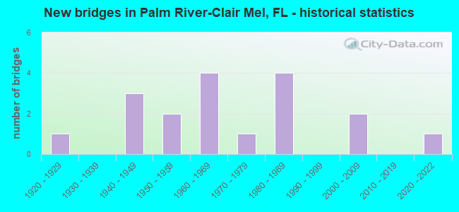
- New bridges - historical statistics
- 11920-1929
- 31940-1949
- 21950-1959
- 41960-1969
- 11970-1979
- 41980-1989
- 22000-2009
- 12020-2022

- Reconstructed bridges - Historical Statistics
- 21950-1959
- 01960-1969
- 11970-1979
- 01980-1989
- 01990-1999
- 12000-2009


- Bridge Condition - Deck
- 11.1%Very good
- 44.4%Good
- 22.2%Satisfactory
- 22.2%Fair

- Bridge Condition - Superstructure
- 11.1%Very good
- 44.4%Good
- 22.2%Satisfactory
- 22.2%Fair

- Bridge Condition - Substructure
- 22.2%Very good
- 66.7%Good
- 11.1%Fair

- Bridge Condition - Channel
- 14.3%Excellent
- 14.3%Very good
- 35.7%Good
- 28.6%Satisfactory
- 7.1%Fair

- Bridge Condition - Culverts
- 28.6%Good
- 42.9%Satisfactory
- 28.6%Fair
Find on map >> Show street view
Structure Number: 34062, Location: Palm River Blvd at CR-846 (Lat: 26.272689, Lng: -81.778533), Route carried "on" structure: County highway , Year Built: 2001, Status: Open, Structure Length: 2.76m (9.06ft), Average Daily Traffic: 1,500 (year 2021), Truck Traffic: 2%, Average Future Daily Traffic: 1,875 (year 2041), Design Load: HS 20, Features Intersected: COCOHATCHEE CANAL, Facility Carried by Structure: PALM RIVER BLVD.
Minimum Vertical Clearance: 30+ m (98+ ft), Kilometerpoint: 0.000, Lanes on structure: 4, Owner: County Highway Agency, Approaching Roadway Width: 15.2m (49.9ft), Skew: 20 degrees, Material/Design: Prestressed concrete, Design/Construction: Slab, Number Of Spans In Main Unit: 3, Length of Maximum Span: 9.2m (30.2ft), Curb or Sidewalk Widths: Left: 2.0m (6.6ft), Right: 2.0m (6.6ft), Curb-To-Curb Width: 15.2m (49.9ft), Out-to-Out Width: 24.2m (79.4ft)
Condition: Deck: Fair, Superstructure: Fair, Substructure: Good, Channel: Very good, Operating Rating: 73.8 metric tons, Method Used To Determine Operating Rating: Load Factor (LF), Inventory Rating: 44.4 metric tons, Method Used To Determine Inventory Rating: Load Factor (LF), Structural Evaluation: Somewhat better than minimum adequacy, Deck Geometry: High priority of corrective action, Waterway Adequacy: Superior to present desirable criteria, Approach Roadway Alignment: Equal to present desirable criteria, Designated Inspection Frequency: Every 24 months, Underwater Inspection Frequency: Every 24 months, Inspection Date: Febuary 2021, Underwater Inspection Date: January 2021, Deck Structure Type: Concrete Precast Panels, Wearing Surface/Protective System: Wearing Surface: Bituminous
Find on map >> Show street view
Structure Number: 100047, Location: 2.8MI SOUTH OF SR 676 (Lat: 27.882828, Lng: -82.395728), Route carried "on" structure: US 41, Year Built: 1943, Year Reconstructed: 1959, Status: Open, Structure Length: 0.98m (3.22ft), Average Daily Traffic: 30,000 (year 2021), Truck Traffic: 10%, Average Future Daily Traffic: 52,050 (year 2041), Design Load: H 15, Features Intersected: ARCHIE CREEK
Minimum Vertical Clearance: 30+ m (98+ ft), Kilometerpoint: 33.286, Lanes on structure: 4, Base Highway Network: Yes, Owner: State Highway Agency, Approaching Roadway Width: 19.8m (65.0ft), Skew: 10 degrees, Material/Design: Concrete, Design/Construction: Culvert, Number Of Spans In Main Unit: 3, Length of Maximum Span: 3.3m (10.8ft)
Condition: Channel: Good, Culverts: Fair, Operating Rating: 83.8 metric tons, Method Used To Determine Operating Rating: Load Factor (LF), Inventory Rating: 50.3 metric tons, Method Used To Determine Inventory Rating: Load Factor (LF), Structural Evaluation: Somewhat better than minimum adequacy, Waterway Adequacy: Equal to present desirable criteria, Approach Roadway Alignment: Equal to present desirable criteria, Designated Inspection Frequency: Every 24 months, Inspection Date: March 2021
Find on map >> Show street view
Structure Number: 100048, Location: 0.5MI SOUTH OF SR-676 (Lat: 27.915100, Lng: -82.401894), Route carried "on" structure: US 41, Year Built: 1959, Status: Open, Structure Length: 1.13m (3.71ft), Average Daily Traffic: 31,229 (year 2021), Truck Traffic: 12%, Average Future Daily Traffic: 54,182 (year 2041), Design Load: H 15, Features Intersected: DELANEY CREEK
Minimum Vertical Clearance: 30+ m (98+ ft), Kilometerpoint: 37.013, Lanes on structure: 7, Base Highway Network: Yes, Owner: State Highway Agency, Approaching Roadway Width: 24.4m (80.1ft), Skew: 12 degrees, Material/Design: Concrete, Design/Construction: Culvert, Number Of Spans In Main Unit: 3, Length of Maximum Span: 3.8m (12.5ft)
Condition: Channel: Good, Culverts: Satisfactory, Operating Rating: 49.9 metric tons, Method Used To Determine Operating Rating: Load Factor (LF), Inventory Rating: 29.9 metric tons, Method Used To Determine Inventory Rating: Load Factor (LF), Structural Evaluation: Equal to present minimum criteria, Waterway Adequacy: Equal to present desirable criteria, Approach Roadway Alignment: Equal to present desirable criteria, Designated Inspection Frequency: Every 24 months, Underwater Inspection Frequency: Every 24 months, Inspection Date: March 2021, Underwater Inspection Date: Febuary 2021
Find on map >> Show street view
Structure Number: 100246, Location: 0.1MI N OF CAUSEWAY BLVD (Lat: 27.923744, Lng: -82.368714), Route carried "on" structure: County highway , Year Built: 1963, Status: Open, Structure Length: 0.98m (3.22ft), Average Daily Traffic: 12,600 (year 2022), Truck Traffic: 5%, Average Future Daily Traffic: 15,750 (year 2042), Design Load: H 15, Features Intersected: DELANEY CREEK, Facility Carried by Structure: 78TH STREET
Minimum Vertical Clearance: 30+ m (98+ ft), Kilometerpoint: 0.032, Lanes on structure: 4, Owner: County Highway Agency, Approaching Roadway Width: 19.1m (62.7ft), Material/Design: Concrete, Design/Construction: Culvert, Number Of Spans In Main Unit: 3, Length of Maximum Span: 3.3m (10.8ft)
Condition: Channel: Satisfactory, Culverts: Satisfactory, Operating Rating: 33.3 metric tons, Method Used To Determine Operating Rating: Load Factor (LF), Inventory Rating: 20.0 metric tons, Method Used To Determine Inventory Rating: Load Factor (LF), Structural Evaluation: Somewhat better than minimum adequacy, Waterway Adequacy: Equal to present desirable criteria, Approach Roadway Alignment: Equal to present desirable criteria, Designated Inspection Frequency: Every 24 months, Inspection Date: January 2022
Find on map >> Show street view
Structure Number: 100288, Location: 0.8 MI WEST OF US-301 (Lat: 27.896750, Lng: -82.350333), Route carried "on" structure: Alternate County highway 676A, Year Built: 1971, Year Reconstructed: 2011, Status: Open, Structure Length: 0.85m (2.79ft), Average Daily Traffic: 6,400 (year 2020), Truck Traffic: 10%, Average Future Daily Traffic: 8,000 (year 2040), Design Load: HS 20, Features Intersected: BLOOMINGDALE CREEK, Facility Carried by Structure: PROGRESS BLVD.
Minimum Vertical Clearance: 30+ m (98+ ft), Kilometerpoint: 5.182, Lanes on structure: 2, Owner: County Highway Agency, Approaching Roadway Width: 16.5m (54.1ft), Skew: 4 degrees, Material/Design: Concrete, Design/Construction: Culvert, Number Of Spans In Main Unit: 2, Length of Maximum Span: 4.3m (14.1ft)
Condition: Channel: Fair, Culverts: Good, Inventory Rating: 63.8 metric tons, Method Used To Determine Inventory Rating: Load Factor (LF), Structural Evaluation: Better than present minimum criteria, Waterway Adequacy: Better than present minimum criteria, Approach Roadway Alignment: Equal to present desirable criteria, Designated Inspection Frequency: Every 24 months, Inspection Date: April 2020
Find on map >> Show street view
Structure Number: 100381, Location: 0.6MI WEST OF US-301 (Lat: 27.895028, Lng: -82.348056), Route carried "on" structure: Alternate County highway 676, Year Built: 1984, Status: Open, Structure Length: 10.94m (35.89ft), Average Daily Traffic: 14,200 (year 2020), Truck Traffic: 13%, Average Future Daily Traffic: 24,637 (year 2042), Design Load: HS 20+Mod, Features Intersected: I-75 (SR-93)
Minimum Vertical Clearance: 30+ m (98+ ft), Kilometerpoint: 5.441, Lanes on structure: 2, Lanes under structure: 10, Owner: State Highway Agency, Approaching Roadway Width: 13.5m (44.3ft), Skew: 2 degrees, Material/Design: Steel continuous, Design/Construction: Stringer/Multi-beam, Number Of Spans In Main Unit: 2, Length of Maximum Span: 54.9m (180.1ft), Curb-To-Curb Width: 13.5m (44.3ft), Out-to-Out Width: 14.4m (47.2ft)
Condition: Deck: Satisfactory, Superstructure: Very good, Substructure: Good, Operating Rating: 48.1 metric tons, Method Used To Determine Operating Rating: Load Factor (LF), Inventory Rating: 29.0 metric tons, Method Used To Determine Inventory Rating: Load Factor (LF), Structural Evaluation: Better than present minimum criteria, Deck Geometry: Superior to present desirable criteria, Underclear: Better than present minimum criteria, Approach Roadway Alignment: Equal to present desirable criteria, Designated Inspection Frequency: Every 24 months, Inspection Date: September 2021, Deck Structure Type: Concrete Cast-file-Place
Find on map >> Show street view
Structure Number: 100467, Location: 0.9 MILE SOUTH OF CR676A (Lat: 27.887783, Lng: -82.398731), Route carried "on" structure: US 41, Year Built: 1943, Year Reconstructed: 1959, Status: Open, Structure Length: 0.73m (2.40ft), Average Daily Traffic: 30,000 (year 2021), Truck Traffic: 10%, Average Future Daily Traffic: 52,050 (year 2041), Features Intersected: FREDS CREEK
Minimum Vertical Clearance: 30+ m (98+ ft), Kilometerpoint: 33.927, Lanes on structure: 4, Base Highway Network: Yes, Owner: State Highway Agency, Approaching Roadway Width: 19.4m (63.6ft), Skew: 13 degrees, Material/Design: Concrete, Design/Construction: Culvert, Number Of Spans In Main Unit: 2, Length of Maximum Span: 3.5m (11.5ft)
Condition: Channel: Good, Culverts: Fair, Operating Rating: 47.2 metric tons, Method Used To Determine Operating Rating: Load and Resistance Factor (LRFR), Inventory Rating: 36.4 metric tons, Method Used To Determine Inventory Rating: Load and Resistance Factor (LRFR), Structural Evaluation: Somewhat better than minimum adequacy, Waterway Adequacy: Better than present minimum criteria, Approach Roadway Alignment: Equal to present desirable criteria, Designated Inspection Frequency: Every 24 months, Inspection Date: March 2021
Find on map >> Show street view
Structure Number: 100483, Location: 2MI SOUTH OF SR-618 (Lat: 27.903692, Lng: -82.344106), Route carried "on" structure: Ramp Interstate 75, Year Built: 1984, Status: Open, Structure Length: 9.75m (31.99ft), Average Daily Traffic: 13,000 (year 2021), Truck Traffic: 9%, Average Future Daily Traffic: 22,555 (year 2041), Design Load: HS 20+Mod, Features Intersected: US-301 (SR-43)
Minimum Vertical Clearance: 30+ m (98+ ft), Kilometerpoint: 0.483, Lanes on structure: 1, Lanes under structure: 8, Owner: State Highway Agency, Approaching Roadway Width: 6.4m (21.0ft), Skew: 3 degrees, Material/Design: Prestressed concrete, Design/Construction: Stringer/Multi-beam, Number Of Spans In Main Unit: 4, Length of Maximum Span: 34.8m (114.2ft), Curb-To-Curb Width: 8.3m (27.2ft), Out-to-Out Width: 9.2m (30.2ft)
Condition: Deck: Good, Superstructure: Good, Substructure: Very good, Operating Rating: 69.9 metric tons, Method Used To Determine Operating Rating: Load Factor (LF), Inventory Rating: 58.1 metric tons, Method Used To Determine Inventory Rating: Load Factor (LF), Structural Evaluation: Better than present minimum criteria, Deck Geometry: Superior to present desirable criteria, Underclear: Better than present minimum criteria, Approach Roadway Alignment: Equal to present desirable criteria, Designated Inspection Frequency: Every 24 months, Inspection Date: October 2021, Deck Structure Type: Concrete Cast-file-Place
Find on map >> Show street view
Structure Number: 104104, Location: 0.4MI N OF CAUSEWAY BLVD (Lat: 27.927861, Lng: -82.360556), Route carried "on" structure: City street , Year Built: 1963, Status: Open, Structure Length: 2.43m (7.97ft), Average Daily Traffic: 1,000 (year 2022), Truck Traffic: 2%, Average Future Daily Traffic: 1,250 (year 2042), Design Load: H 15, Features Intersected: DELANEY CREEK, Facility Carried by Structure: 86TH STREET
Minimum Vertical Clearance: 30+ m (98+ ft), Kilometerpoint: 0.000, Lanes on structure: 2, Owner: County Highway Agency, Approaching Roadway Width: 6.4m (21.0ft), Skew: 3 degrees, Material/Design: Prestressed concrete, Design/Construction: Channel Beam, Number Of Spans In Main Unit: 3, Length of Maximum Span: 8.0m (26.2ft), Curb-To-Curb Width: 8.6m (28.2ft), Out-to-Out Width: 9.3m (30.5ft)
Condition: Deck: Good, Superstructure: Good, Substructure: Good, Channel: Satisfactory, Operating Rating: 49.4 metric tons, Method Used To Determine Operating Rating: Load Factor (LF), Inventory Rating: 29.6 metric tons, Method Used To Determine Inventory Rating: Load Factor (LF), Structural Evaluation: Better than present minimum criteria, Deck Geometry: Somewhat better than minimum adequacy, Waterway Adequacy: Better than present minimum criteria, Approach Roadway Alignment: Equal to present desirable criteria, Designated Inspection Frequency: Every 24 months, Inspection Date: January 2022, Deck Structure Type: Concrete Cast-file-Place, Wearing Surface/Protective System: Wearing Surface: Epoxy Overlay
Find on map >> Show street view
Structure Number: 104105, Location: 0.09MI S OF CAUSEWAY BLVD (Lat: 27.921750, Lng: -82.376944), Route carried "on" structure: City street , Year Built: 1940, Year Reconstructed: 1983, Status: Open, Structure Length: 0.85m (2.79ft), Average Daily Traffic: 1,020 (year 2022), Truck Traffic: 2%, Average Future Daily Traffic: 1,275 (year 2042), Features Intersected: DELANEY CREEK, Facility Carried by Structure: 70TH ST SOUTH
Minimum Vertical Clearance: 30+ m (98+ ft), Kilometerpoint: 0.000, Lanes on structure: 2, Owner: County Highway Agency, Approaching Roadway Width: 6.1m (20.0ft), Material/Design: Steel, Design/Construction: Stringer/Multi-beam, Number Of Spans In Main Unit: 1, Length of Maximum Span: 8.5m (27.9ft), Curb-To-Curb Width: 6.7m (22.0ft), Out-to-Out Width: 7.4m (24.3ft)
Condition: Deck: Good, Superstructure: Satisfactory, Substructure: Fair, Channel: Good, Operating Rating: 66.6 metric tons, Method Used To Determine Operating Rating: Load Factor (LF), Inventory Rating: 40.0 metric tons, Method Used To Determine Inventory Rating: Load Factor (LF), Structural Evaluation: Somewhat better than minimum adequacy, Deck Geometry: High priority of corrective action, Waterway Adequacy: Better than present minimum criteria, Approach Roadway Alignment: Equal to present desirable criteria, Designated Inspection Frequency: Every 24 months, Inspection Date: January 2022, Deck Structure Type: Concrete Cast-file-Place, Wearing Surface/Protective System: Wearing Surface: Bituminous
Find on map >> Show street view
Structure Number: 104107, Location: AT 36TH AVE AND 54TH ST (Lat: 27.915464, Lng: -82.393392), Route carried "on" structure: County highway , Year Built: 1965, Status: Open, Structure Length: 1.58m (5.18ft), Average Daily Traffic: 1,000 (year 2022), Truck Traffic: 2%, Average Future Daily Traffic: 1,250 (year 2042), Design Load: H 15, Features Intersected: DELANEY CREEK, Facility Carried by Structure: 36TH AVE
Minimum Vertical Clearance: 30+ m (98+ ft), Kilometerpoint: 0.000, Lanes on structure: 2, Owner: County Highway Agency, Approaching Roadway Width: 6.7m (22.0ft), Skew: 2 degrees, Material/Design: Prestressed concrete, Design/Construction: Channel Beam, Number Of Spans In Main Unit: 2, Length of Maximum Span: 7.9m (25.9ft), Curb-To-Curb Width: 8.6m (28.2ft), Out-to-Out Width: 9.1m (29.9ft)
Condition: Deck: Good, Superstructure: Satisfactory, Substructure: Good, Channel: Good, Operating Rating: 50.7 metric tons, Method Used To Determine Operating Rating: Load Factor (LF), Inventory Rating: 30.4 metric tons, Method Used To Determine Inventory Rating: Load Factor (LF), Structural Evaluation: Equal to present minimum criteria, Deck Geometry: Somewhat better than minimum adequacy, Waterway Adequacy: Equal to present minimum criteria, Approach Roadway Alignment: Equal to present desirable criteria, Designated Inspection Frequency: Every 24 months, Inspection Date: January 2022, Deck Structure Type: Concrete Cast-file-Place
Find on map >> Show street view
Structure Number: 104136, Location: 1.2MI WEST OF US-41 (Lat: 27.906408, Lng: -82.422500), Route carried "on" structure: County highway , Year Built: 1952, Status: Open, Structure Length: 1.01m (3.31ft), Average Daily Traffic: 2,000 (year 2020), Truck Traffic: 40%, Average Future Daily Traffic: 3,470 (year 2042), Design Load: H 20, Features Intersected: GANNON STA DISCHARGE 1, Facility Carried by Structure: PORT SUTTON ROAD
Minimum Vertical Clearance: 30+ m (98+ ft), Kilometerpoint: 0.000, Lanes on structure: 2, Owner: County Highway Agency, Approaching Roadway Width: 7.8m (25.6ft), Material/Design: Concrete, Design/Construction: Tee Beam, Number Of Spans In Main Unit: 1, Length of Maximum Span: 10.1m (33.1ft), Curb-To-Curb Width: 7.8m (25.6ft), Out-to-Out Width: 9.2m (30.2ft)
Condition: Deck: Satisfactory, Superstructure: Good, Substructure: Good, Channel: Excellent, Operating Rating: 52.3 metric tons, Method Used To Determine Operating Rating: Load Factor (LF), Inventory Rating: 31.4 metric tons, Method Used To Determine Inventory Rating: Load Factor (LF), Structural Evaluation: Better than present minimum criteria, Deck Geometry: Meets minimum limits, Waterway Adequacy: Meets minimum limits, Approach Roadway Alignment: Equal to present desirable criteria, Length Of Structure Improvement: 1.01m (3.31ft), Designated Inspection Frequency: Every 24 months, Underwater Inspection Frequency: Every 22 months, Inspection Date: October 2021, Underwater Inspection Date: November 2021, Bridge Improvement Cost: $205,000, Roadway Improvement Cost: $20,000, Total Project Cost: $225,000, Deck Structure Type: Concrete Cast-file-Place, Wearing Surface/Protective System: Wearing Surface: Bituminous
Find on map >> Show street view
Structure Number: 104137, Location: 1.2MI WEST OF US-41 (Lat: 27.906406, Lng: -82.422281), Route carried "on" structure: County highway , Year Built: 1965, Status: Open, Structure Length: 1.13m (3.71ft), Average Daily Traffic: 2,000 (year 2021), Truck Traffic: 40%, Average Future Daily Traffic: 3,470 (year 2042), Design Load: HS 20, Features Intersected: GANNON STA DISCHARGE 2, Facility Carried by Structure: PORT SUTTON ROAD
Minimum Vertical Clearance: 30+ m (98+ ft), Kilometerpoint: 0.000, Lanes on structure: 2, Owner: County Highway Agency, Approaching Roadway Width: 7.8m (25.6ft), Material/Design: Prestressed concrete, Design/Construction: Slab, Number Of Spans In Main Unit: 1, Length of Maximum Span: 11.3m (37.1ft), Curb-To-Curb Width: 7.8m (25.6ft), Out-to-Out Width: 9.9m (32.5ft)
Condition: Deck: Fair, Superstructure: Fair, Substructure: Good, Channel: Excellent, Operating Rating: 49.7 metric tons, Method Used To Determine Operating Rating: Allowable Stress (AS), Inventory Rating: 26.7 metric tons, Method Used To Determine Inventory Rating: Allowable Stress (AS), Structural Evaluation: Somewhat better than minimum adequacy, Deck Geometry: Meets minimum limits, Waterway Adequacy: Meets minimum limits, Approach Roadway Alignment: Equal to present desirable criteria, Length Of Structure Improvement: 1.13m (3.71ft), Designated Inspection Frequency: Every 24 months, Underwater Inspection Frequency: Every 22 months, Inspection Date: October 2021, Underwater Inspection Date: November 2021, Bridge Improvement Cost: $246,000, Roadway Improvement Cost: $24,000, Total Project Cost: $270,000, Deck Structure Type: Concrete Precast Panels, Wearing Surface/Protective System: Wearing Surface: Bituminous
Find on map >> Show street view
Structure Number: 104155, Location: 0.25 MILE S OF CR-676 (Lat: 27.919222, Lng: -82.385028), Route carried "on" structure: County highway , Year Built: 2002, Status: Open, Structure Length: 1.19m (3.90ft), Average Daily Traffic: 100 (year 2022), Truck Traffic: 2%, Average Future Daily Traffic: 125 (year 2042), Design Load: HS 25 or greater, Features Intersected: DELANEY CREEK, Facility Carried by Structure: MAYDELL DRIVE
Minimum Vertical Clearance: 30+ m (98+ ft), Kilometerpoint: 0.000, Lanes on structure: 2, Owner: County Highway Agency, Approaching Roadway Width: 7.3m (24.0ft), Material/Design: Concrete, Design/Construction: Culvert, Number Of Spans In Main Unit: 1, Length of Maximum Span: 11.9m (39.0ft)
Condition: Channel: Satisfactory, Culverts: Good, Operating Rating: 66.0 metric tons, Method Used To Determine Operating Rating: Load Factor (LF), Inventory Rating: 39.6 metric tons, Method Used To Determine Inventory Rating: Load Factor (LF), Structural Evaluation: Better than present minimum criteria, Waterway Adequacy: Better than present minimum criteria, Approach Roadway Alignment: Equal to present desirable criteria, Designated Inspection Frequency: Every 24 months, Inspection Date: January 2022
Find on map >> Show street view
Structure Number: 104333, Location: 1.2MI NE OF US-41 (Lat: 27.885058, Lng: -82.391753), Route carried "on" structure: Alternate County highway 41A, Year Built: 1925, Status: Open, Structure Length: 0.87m (2.85ft), Average Daily Traffic: 990 (year 2021), Truck Traffic: 10%, Average Future Daily Traffic: 1,237 (year 2041), Features Intersected: RACEWAY CANAL
Minimum Vertical Clearance: 30+ m (98+ ft), Kilometerpoint: 0.000, Lanes on structure: 2, Owner: County Highway Agency, Approaching Roadway Width: 6.6m (21.7ft), Skew: 2 degrees, Material/Design: Concrete, Design/Construction: Culvert, Number Of Spans In Main Unit: 2, Length of Maximum Span: 4.3m (14.1ft), Curb-To-Curb Width: 7.3m (24.0ft), Out-to-Out Width: 8.0m (26.2ft)
Condition: Channel: Satisfactory, Culverts: Satisfactory, Operating Rating: 33.7 metric tons, Method Used To Determine Operating Rating: Load Factor (LF), Inventory Rating: 20.2 metric tons, Method Used To Determine Inventory Rating: Load Factor (LF), Structural Evaluation: Somewhat better than minimum adequacy, Deck Geometry: Meets minimum limits, Waterway Adequacy: Better than present minimum criteria, Approach Roadway Alignment: Better than present minimum criteria, Designated Inspection Frequency: Every 24 months, Underwater Inspection Frequency: Every 24 months, Inspection Date: October 2021, Underwater Inspection Date: October 2021
Find on map >> Show street view
Structure Number: 104493, Location: 0.2MI S/O SR-60(ADAMO DR) (Lat: 27.949167, Lng: -82.385361), Route carried "on" structure: County highway , Year Built: 2021, Status: Open, Structure Length: 19.20m (62.99ft), Average Daily Traffic: 2,800 (year 2021), Truck Traffic: 7%, Average Future Daily Traffic: 3,500 (year 2041), Design Load: HL 93, Features Intersected: PALM RIVER, Facility Carried by Structure: MAYDELL DRIVE
Minimum Vertical Clearance: 30.45m (99.90ft), Kilometerpoint: 0.000, Lanes on structure: 2, Owner: County Highway Agency, Approaching Roadway Width: 11.6m (38.1ft), Material/Design: Prestressed concrete, Design/Construction: Stringer/Multi-beam, Number Of Spans In Main Unit: 7, Length of Maximum Span: 27.4m (89.9ft), Curb or Sidewalk Widths: Left: 3.0m (9.8ft), Right: 1.5m (4.9ft), Curb-To-Curb Width: 11.6m (38.1ft), Out-to-Out Width: 17.6m (57.7ft)
Condition: Deck: Very good, Superstructure: Good, Substructure: Very good, Channel: Very good, Operating Rating: 59.4 metric tons, Method Used To Determine Operating Rating: Load and Resistance Factor (LRFR), Inventory Rating: 39.6 metric tons, Method Used To Determine Inventory Rating: Load and Resistance Factor (LRFR), Structural Evaluation: Better than present minimum criteria, Deck Geometry: Somewhat better than minimum adequacy, Waterway Adequacy: Equal to present desirable criteria, Approach Roadway Alignment: Equal to present desirable criteria, Designated Inspection Frequency: Every 24 months, Underwater Inspection Frequency: Every 23 months, Inspection Date: December 2021, Underwater Inspection Date: December 2021, Deck Structure Type: Concrete Cast-file-Place, Wearing Surface/Protective System: Wearing Surface: Monolithic Concrete
Find on map >> Show street view
Structure Number: 100381, Location: 0.6MI WEST OF US-301 (Lat: 27.895028, Lng: -82.348056), Route carried "under" structure: Interstate 75, Year Built: 1984, Structure Length: 0. m, Average Daily Traffic: 143,500 (year 2020), Truck Traffic: 12%, Features Intersected: I-75 (SR-93), Facility Carried by Structure: CR676A PROGRESS BD
Minimum Vertical Clearance: 5.18m (16.99ft), Kilometerpoint: 31.348, Lanes on structure: 2, Lanes under structure: 10, Material/Design: Steel continuous, Design/Construction: Stringer/Multi-beam, Length of Maximum Span: 54.9m (180.1ft)
Find on map >> Show street view
Structure Number: 100483, Location: 2MI SOUTH OF SR-618 (Lat: 27.903692, Lng: -82.344106), Route carried "under" structure: US 301, Year Built: 1984, Structure Length: 0. m, Average Daily Traffic: 50,000 (year 2021), Truck Traffic: 6%, Features Intersected: US-301 (SR-43)
Minimum Vertical Clearance: 4.91m (16.11ft), Kilometerpoint: 31.028, Lanes on structure: 1, Lanes under structure: 7, Material/Design: Prestressed concrete, Design/Construction: Stringer/Multi-beam, Length of Maximum Span: 34.8m (114.2ft)