Bridge Statistics for Palm Bay, Florida (FL)
Condition, Traffic, Stress, Structural Evaluation, Project Costs
- National Bridge Inventory (NBI) Statistics
- 36Number of bridges
- 505ft / 154mTotal length
- $401,000Total costs
- 721,405Total average daily traffic
- 82,103Total average daily truck traffic
- National Bridge Inventory (NBI) Registered Bridges for Palm Bay
- No street view available for this location
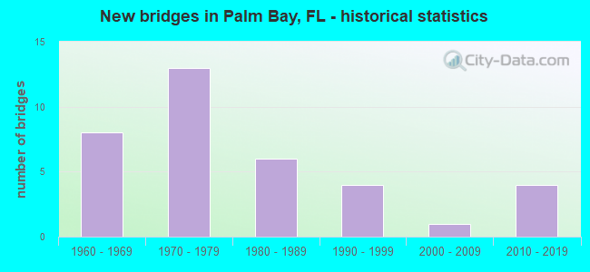
- New bridges - historical statistics
- 81960-1969
- 131970-1979
- 61980-1989
- 41990-1999
- 12000-2009
- 42010-2019

- Reconstructed bridges - Historical Statistics
- 11980-1989
- 21990-1999
- 22000-2009
- 32010-2019


- Bridge Condition - Deck
- 6.9%Very good
- 79.3%Good
- 6.9%Satisfactory
- 6.9%Fair

- Bridge Condition - Superstructure
- 13.8%Very good
- 75.9%Good
- 3.4%Satisfactory
- 6.9%Fair

- Bridge Condition - Substructure
- 6.9%Very good
- 89.7%Good
- 3.4%Fair

- Bridge Condition - Channel
- 14.8%Very good
- 77.8%Good
- 7.4%Satisfactory

- Bridge Condition - Culverts
- 25.0%Very good
- 50.0%Good
- 25.0%Satisfactory
Find on map >> Show street view
Structure Number: 700034, Location: I-95 SB- Tillman Canal (Lat: 28.013306, Lng: -80.641111), Route carried "on" structure: Interstate 95, Year Built: 1964, Year Reconstructed: 2010, Status: Open, Structure Length: 9.30m (30.51ft), Average Daily Traffic: 31,250 (year 2020), Truck Traffic: 10%, Average Future Daily Traffic: 54,219 (year 2042), Design Load: HL 93, Features Intersected: Tillman Canal
Minimum Vertical Clearance: 30+ m (98+ ft), Kilometerpoint: 23.273, Lanes on structure: 3, Base Highway Network: Yes, Owner: State Highway Agency, Approaching Roadway Width: 17.2m (56.4ft), Skew: 3 degrees, Material/Design: Prestressed concrete, Design/Construction: Stringer/Multi-beam, Number Of Spans In Main Unit: 5, Length of Maximum Span: 18.6m (61.0ft), Curb-To-Curb Width: 17.2m (56.4ft), Out-to-Out Width: 18.1m (59.4ft)
Condition: Deck: Good, Superstructure: Good, Substructure: Good, Channel: Good, Operating Rating: 55.8 metric tons, Method Used To Determine Operating Rating: Load and Resistance Factor (LRFR), Inventory Rating: 42.5 metric tons, Method Used To Determine Inventory Rating: Load and Resistance Factor (LRFR), Structural Evaluation: Better than present minimum criteria, Deck Geometry: Better than present minimum criteria, Approach Roadway Alignment: Equal to present desirable criteria, Designated Inspection Frequency: Every 24 months, Underwater Inspection Frequency: Every 24 months, Inspection Date: January 2021, Underwater Inspection Date: January 2021, Deck Structure Type: Concrete Cast-file-Place
Find on map >> Show street view
Structure Number: 700097, Location: 2.2 Mi. S of Grant Rd. (Lat: 27.892436, Lng: -80.594006), Route carried "on" structure: Interstate 95, Year Built: 1969, Year Reconstructed: 2019, Status: Open, Structure Length: 0.69m (2.26ft), Average Daily Traffic: 43,131 (year 2020), Truck Traffic: 17%, Average Future Daily Traffic: 74,832 (year 2042), Design Load: HS 20, Features Intersected: Outfall Ditch
Minimum Vertical Clearance: 30+ m (98+ ft), Kilometerpoint: 9.101, Lanes on structure: 7, Base Highway Network: Yes, Owner: State Highway Agency, Approaching Roadway Width: 34.8m (114.2ft), Skew: 23 degrees, Material/Design: Concrete, Design/Construction: Culvert, Number Of Spans In Main Unit: 3, Length of Maximum Span: 2.2m (7.2ft)
Condition: Channel: Satisfactory, Culverts: Satisfactory, Operating Rating: 57.5 metric tons, Method Used To Determine Operating Rating: Load Factor (LF), Inventory Rating: 34.7 metric tons, Method Used To Determine Inventory Rating: Load Factor (LF), Structural Evaluation: Equal to present minimum criteria, Waterway Adequacy: Equal to present desirable criteria, Approach Roadway Alignment: Equal to present desirable criteria, Designated Inspection Frequency: Every 24 months, Underwater Inspection Frequency: Every 24 months, Inspection Date: August 2021, Underwater Inspection Date: August 2021, Wearing Surface/Protective System: Wearing Surface: Other
Find on map >> Show street view
Structure Number: 700099, Location: 1.2 Mi S of Grant Rd (Lat: 27.906667, Lng: -80.597642), Route carried "on" structure: Interstate 95, Year Built: 1969, Year Reconstructed: 2013, Status: Open, Structure Length: 0.94m (3.08ft), Average Daily Traffic: 43,131 (year 2020), Truck Traffic: 18%, Average Future Daily Traffic: 74,832 (year 2042), Design Load: H 20, Features Intersected: Outfall
Minimum Vertical Clearance: 30+ m (98+ ft), Kilometerpoint: 10.586, Lanes on structure: 6, Base Highway Network: Yes, Owner: State Highway Agency, Approaching Roadway Width: 34.4m (112.9ft), Skew: 30 degrees, Material/Design: Concrete, Design/Construction: Culvert, Number Of Spans In Main Unit: 3, Length of Maximum Span: 3.0m (9.8ft)
Condition: Channel: Good, Culverts: Good, Inventory Rating: 62.8 metric tons, Method Used To Determine Inventory Rating: Load Factor (LF), Structural Evaluation: Better than present minimum criteria, Waterway Adequacy: Equal to present desirable criteria, Approach Roadway Alignment: Equal to present desirable criteria, Designated Inspection Frequency: Every 24 months, Inspection Date: January 2021
Find on map >> Show street view
Structure Number: 700101, Location: 0.4 Mi N of Grant Rd. (Lat: 27.930917, Lng: -80.603883), Route carried "on" structure: Interstate 95, Year Built: 1969, Status: Open, Structure Length: 0.98m (3.22ft), Average Daily Traffic: 43,131 (year 2020), Truck Traffic: 18%, Average Future Daily Traffic: 74,832 (year 2042), Design Load: H 20, Features Intersected: Grant Canal
Minimum Vertical Clearance: 30+ m (98+ ft), Kilometerpoint: 13.333, Lanes on structure: 7, Base Highway Network: Yes, Owner: State Highway Agency, Approaching Roadway Width: 43.2m (141.7ft), Skew: 11 degrees, Material/Design: Concrete, Design/Construction: Culvert, Number Of Spans In Main Unit: 3, Length of Maximum Span: 3.0m (9.8ft)
Condition: Channel: Good, Culverts: Good, Inventory Rating: 62.8 metric tons, Method Used To Determine Inventory Rating: Load Factor (LF), Structural Evaluation: Better than present minimum criteria, Waterway Adequacy: Equal to present desirable criteria, Approach Roadway Alignment: Equal to present desirable criteria, Designated Inspection Frequency: Every 24 months, Underwater Inspection Frequency: Every 24 months, Inspection Date: March 2021, Underwater Inspection Date: March 2021
Find on map >> Show street view
Structure Number: 700119, Location: I-95 NB - Tillman Canal (Lat: 28.013158, Lng: -80.640719), Route carried "on" structure: Interstate 95, Year Built: 1964, Year Reconstructed: 2010, Status: Open, Structure Length: 9.30m (30.51ft), Average Daily Traffic: 31,250 (year 2020), Truck Traffic: 10%, Average Future Daily Traffic: 54,219 (year 2042), Design Load: HL 93, Features Intersected: Tillman Canal
Minimum Vertical Clearance: 30+ m (98+ ft), Kilometerpoint: 23.263, Lanes on structure: 3, Base Highway Network: Yes, Owner: State Highway Agency, Approaching Roadway Width: 17.2m (56.4ft), Skew: 3 degrees, Material/Design: Prestressed concrete, Design/Construction: Stringer/Multi-beam, Number Of Spans In Main Unit: 5, Length of Maximum Span: 18.6m (61.0ft), Curb-To-Curb Width: 17.2m (56.4ft), Out-to-Out Width: 18.1m (59.4ft)
Condition: Deck: Good, Superstructure: Very good, Substructure: Good, Channel: Good, Operating Rating: 55.8 metric tons, Method Used To Determine Operating Rating: Load and Resistance Factor (LRFR), Inventory Rating: 42.5 metric tons, Method Used To Determine Inventory Rating: Load and Resistance Factor (LRFR), Structural Evaluation: Better than present minimum criteria, Deck Geometry: Better than present minimum criteria, Waterway Adequacy: Equal to present desirable criteria, Approach Roadway Alignment: Equal to present desirable criteria, Designated Inspection Frequency: Every 24 months, Underwater Inspection Frequency: Every 24 months, Inspection Date: January 2021, Underwater Inspection Date: January 2021, Deck Structure Type: Concrete Cast-file-Place
Find on map >> Show street view
Structure Number: 70016, Location: Babcock Street over I-95 (Lat: 27.986639, Lng: -80.622006), Route carried "on" structure: County highway 507, Year Built: 1969, Status: Open, Structure Length: 12.43m (40.78ft), Average Daily Traffic: 12,200 (year 2020), Truck Traffic: 6%, Average Future Daily Traffic: 21,167 (year 2042), Design Load: H 20, Features Intersected: I-95
Minimum Vertical Clearance: 30+ m (98+ ft), Kilometerpoint: 6.824, Lanes on structure: 2, Lanes under structure: 6, Owner: State Highway Agency, Approaching Roadway Width: 7.3m (24.0ft), Skew: 5 degrees, Material/Design: Steel continuous, Design/Construction: Stringer/Multi-beam, Number Of Spans In Main Unit: 4, Length of Maximum Span: 40.8m (133.9ft), Curb or Sidewalk Widths: Left: 0.5m (1.6ft), Right: 0.5m (1.6ft), Curb-To-Curb Width: 9.4m (30.8ft), Out-to-Out Width: 10.6m (34.8ft)
Condition: Deck: Satisfactory, Superstructure: Good, Substructure: Fair, Operating Rating: 40.5 metric tons, Method Used To Determine Operating Rating: Load Factor (LF), Inventory Rating: 24.2 metric tons, Method Used To Determine Inventory Rating: Load Factor (LF), Structural Evaluation: Somewhat better than minimum adequacy, Deck Geometry: Meets minimum limits, Underclear: Somewhat better than minimum adequacy, Approach Roadway Alignment: Equal to present desirable criteria, Length Of Structure Improvement: 12.37m (40.58ft), Designated Inspection Frequency: Every 24 months, Inspection Date: March 2021, Bridge Improvement Cost: $134,000, Total Project Cost: $401,000, Deck Structure Type: Concrete Cast-file-Place
Find on map >> Show street view
Structure Number: 700185, Location: SR-507 NB - Tillman Canal (Lat: 28.013167, Lng: -80.622139), Route carried "on" structure: State highway 507, Year Built: 1962, Year Reconstructed: 1991, Status: Open, Structure Length: 6.98m (22.90ft), Average Daily Traffic: 17,750 (year 2020), Truck Traffic: 14%, Average Future Daily Traffic: 30,796 (year 2042), Design Load: H 20, Features Intersected: Tillman Canal
Minimum Vertical Clearance: 30+ m (98+ ft), Kilometerpoint: 1.590, Lanes on structure: 2, Owner: State Highway Agency, Approaching Roadway Width: 8.8m (28.9ft), Skew: 20 degrees, Material/Design: Prestressed concrete, Design/Construction: Slab, Number Of Spans In Main Unit: 7, Length of Maximum Span: 9.9m (32.5ft), Curb or Sidewalk Widths: Left: 0.0m, Right: 2.1m (6.9ft), Curb-To-Curb Width: 9.7m (31.8ft), Out-to-Out Width: 15.6m (51.2ft)
Condition: Deck: Fair, Superstructure: Fair, Substructure: Good, Channel: Good, Operating Rating: 49.3 metric tons, Method Used To Determine Operating Rating: Load Factor (LF), Inventory Rating: 29.6 metric tons, Method Used To Determine Inventory Rating: Load Factor (LF), Structural Evaluation: Somewhat better than minimum adequacy, Deck Geometry: Meets minimum limits, Waterway Adequacy: Better than present minimum criteria, Approach Roadway Alignment: Equal to present desirable criteria, Designated Inspection Frequency: Every 24 months, Underwater Inspection Frequency: Every 24 months, Inspection Date: Febuary 2022, Underwater Inspection Date: Febuary 2022, Deck Structure Type: Concrete Precast Panels, Wearing Surface/Protective System: Wearing Surface: Bituminous
Find on map >> Show street view
Structure Number: 700188, Location: CR-516 over I-95 (Lat: 28.035356, Lng: -80.656647), Route carried "on" structure: County highway 516, Year Built: 1988, Year Reconstructed: 2009, Status: Open, Structure Length: 8.90m (29.20ft), Average Daily Traffic: 47,500 (year 2020), Truck Traffic: 6%, Average Future Daily Traffic: 82,412 (year 2042), Design Load: HL 93, Features Intersected: I-95
Minimum Vertical Clearance: 30+ m (98+ ft), Kilometerpoint: 0.000, Lanes on structure: 6, Lanes under structure: 6, Base Highway Network: Yes, Owner: State Highway Agency, Approaching Roadway Width: 24.4m (80.1ft), Skew: 23 degrees, Material/Design: Prestressed concrete, Design/Construction: Stringer/Multi-beam, Number Of Spans In Main Unit: 4, Length of Maximum Span: 32.1m (105.3ft), Curb or Sidewalk Widths: Left: 2.4m (7.9ft), Right: 2.4m (7.9ft), Curb-To-Curb Width: 24.4m (80.1ft), Out-to-Out Width: 36.7m (120.4ft)
Condition: Deck: Good, Superstructure: Good, Substructure: Good, Operating Rating: 44.5 metric tons, Method Used To Determine Operating Rating: Load and Resistance Factor (LRFR), Inventory Rating: 38.8 metric tons, Method Used To Determine Inventory Rating: Load and Resistance Factor (LRFR), Structural Evaluation: Better than present minimum criteria, Deck Geometry: Somewhat better than minimum adequacy, Underclear: Somewhat better than minimum adequacy, Approach Roadway Alignment: Equal to present desirable criteria, Designated Inspection Frequency: Every 24 months, Inspection Date: March 2021, Deck Structure Type: Concrete Cast-file-Place
Find on map >> Show street view
Structure Number: 70019, Location: SR-507 SB-Tillman Canal (Lat: 28.013167, Lng: -80.622306), Route carried "on" structure: State highway 507, Year Built: 1991, Status: Open, Structure Length: 6.98m (22.90ft), Average Daily Traffic: 17,750 (year 2020), Truck Traffic: 14%, Average Future Daily Traffic: 30,796 (year 2042), Design Load: HS 20, Features Intersected: Tillman Canal
Minimum Vertical Clearance: 30+ m (98+ ft), Kilometerpoint: 1.590, Lanes on structure: 2, Owner: State Highway Agency, Approaching Roadway Width: 8.8m (28.9ft), Skew: 20 degrees, Material/Design: Concrete continuous, Design/Construction: Slab, Number Of Spans In Main Unit: 7, Length of Maximum Span: 9.8m (32.2ft), Curb or Sidewalk Widths: Left: 2.1m (6.9ft), Right: 0.0m, Curb-To-Curb Width: 9.6m (31.5ft), Out-to-Out Width: 14.9m (48.9ft)
Condition: Deck: Satisfactory, Superstructure: Satisfactory, Substructure: Good, Channel: Good, Operating Rating: 63.5 metric tons, Method Used To Determine Operating Rating: Load Factor (LF), Inventory Rating: 38.1 metric tons, Method Used To Determine Inventory Rating: Load Factor (LF), Structural Evaluation: Equal to present minimum criteria, Deck Geometry: Meets minimum limits, Waterway Adequacy: Equal to present desirable criteria, Approach Roadway Alignment: Equal to present desirable criteria, Designated Inspection Frequency: Every 24 months, Underwater Inspection Frequency: Every 24 months, Inspection Date: Febuary 2022, Underwater Inspection Date: Febuary 2022, Deck Structure Type: Concrete Cast-file-Place, Wearing Surface/Protective System: Wearing Surface: Monolithic Concrete
Find on map >> Show street view
Structure Number: 700239, Location: Ellis Rd-I95 Utility Ease (Lat: 28.098950, Lng: -80.706722), Route carried "on" structure: County highway 509, Year Built: 2019, Status: Open, Structure Length: 8.87m (29.10ft), Average Daily Traffic: 19,400 (year 2019), Truck Traffic: 5%, Average Future Daily Traffic: 33,312 (year 2041), Design Load: HL 93, Features Intersected: I-95 Utility Easement, Facility Carried by Structure: Ellis Road
Minimum Vertical Clearance: 30+ m (98+ ft), Kilometerpoint: 0.000, Lanes on structure: 4, Owner: State Highway Agency, Approaching Roadway Width: 25.6m (84.0ft), Skew: 20 degrees, Material/Design: Prestressed concrete, Design/Construction: Stringer/Multi-beam, Number Of Spans In Main Unit: 2, Length of Maximum Span: 44.3m (145.3ft), Curb or Sidewalk Widths: Left: 2.6m (8.5ft), Right: 2.6m (8.5ft), Curb-To-Curb Width: 25.6m (84.0ft), Out-to-Out Width: 38.7m (127.0ft)
Condition: Deck: Very good, Superstructure: Very good, Substructure: Very good, Operating Rating: 52.9 metric tons, Method Used To Determine Operating Rating: Load and Resistance Factor (LRFR), Inventory Rating: 38.2 metric tons, Method Used To Determine Inventory Rating: Load and Resistance Factor (LRFR), Structural Evaluation: Equal to present desirable criteria, Deck Geometry: Superior to present desirable criteria, Approach Roadway Alignment: Equal to present desirable criteria, Designated Inspection Frequency: Every 24 months, Inspection Date: March 2020, Deck Structure Type: Concrete Cast-file-Place
Find on map >> Show street view
Structure Number: 704004, Location: 2.5 Miles West of CR-509 (Lat: 27.999000, Lng: -80.712817), Route carried "on" structure: County highway 514, Year Built: 1972, Status: Open, Structure Length: 4.27m (14.01ft), Average Daily Traffic: 12,800 (year 2020), Truck Traffic: 4%, Average Future Daily Traffic: 22,305 (year 2042), Design Load: HS 20, Features Intersected: Canal, Facility Carried by Structure: Malabar Rd
Minimum Vertical Clearance: 30+ m (98+ ft), Kilometerpoint: 2.433, Lanes on structure: 2, Owner: County Highway Agency, Approaching Roadway Width: 8.6m (28.2ft), Material/Design: Prestressed concrete, Design/Construction: Slab, Number Of Spans In Main Unit: 5, Length of Maximum Span: 8.5m (27.9ft), Curb or Sidewalk Widths: Left: 0.9m (3.0ft), Right: 0.9m (3.0ft), Curb-To-Curb Width: 8.6m (28.2ft), Out-to-Out Width: 11.2m (36.7ft)
Condition: Deck: Fair, Superstructure: Fair, Substructure: Good, Channel: Good, Operating Rating: 49.0 metric tons, Method Used To Determine Operating Rating: Load Factor (LF), Inventory Rating: 38.2 metric tons, Method Used To Determine Inventory Rating: Load Factor (LF), Structural Evaluation: Somewhat better than minimum adequacy, Deck Geometry: High priority of replacement, Waterway Adequacy: Equal to present desirable criteria, Approach Roadway Alignment: Equal to present desirable criteria, Designated Inspection Frequency: Every 24 months, Underwater Inspection Frequency: Every 24 months, Inspection Date: Febuary 2022, Underwater Inspection Date: Febuary 2022, Deck Structure Type: Concrete Precast Panels, Wearing Surface/Protective System: Wearing Surface: Bituminous
Find on map >> Show street view
Structure Number: 704042, Location: 8 mi South of Malabar Rd (Lat: 27.888578, Lng: -80.622453), Route carried "on" structure: County highway 507, Year Built: 1980, Status: Open, Structure Length: 2.74m (8.99ft), Average Daily Traffic: 24,500 (year 2020), Truck Traffic: 6%, Average Future Daily Traffic: 42,500 (year 2042), Design Load: HS 20, Features Intersected: Sebastian Canal, Facility Carried by Structure: Babcock Street
Minimum Vertical Clearance: 30+ m (98+ ft), Kilometerpoint: 7.860, Lanes on structure: 2, Owner: County Highway Agency, Approaching Roadway Width: 11.5m (37.7ft), Material/Design: Prestressed concrete, Design/Construction: Slab, Number Of Spans In Main Unit: 3, Length of Maximum Span: 9.1m (29.9ft), Curb-To-Curb Width: 12.4m (40.7ft), Out-to-Out Width: 13.2m (43.3ft)
Condition: Deck: Good, Superstructure: Good, Substructure: Good, Channel: Good, Operating Rating: 45.4 metric tons, Method Used To Determine Operating Rating: Load Factor (LF), Inventory Rating: 27.1 metric tons, Method Used To Determine Inventory Rating: Load Factor (LF), Structural Evaluation: Equal to present minimum criteria, Deck Geometry: Somewhat better than minimum adequacy, Waterway Adequacy: Equal to present desirable criteria, Approach Roadway Alignment: Equal to present desirable criteria, Designated Inspection Frequency: Every 24 months, Inspection Date: Febuary 2022, Deck Structure Type: Concrete Precast Panels, Wearing Surface/Protective System: Wearing Surface: Bituminous
Find on map >> Show street view
Structure Number: 704075, Location: 2.4 mi S of SR-9 (Lat: 28.013700, Lng: -80.672158), Route carried "on" structure: County highway 509, Year Built: 1985, Year Reconstructed: 1996, Status: Open, Structure Length: 4.94m (16.21ft), Average Daily Traffic: 27,000 (year 2020), Truck Traffic: 6%, Average Future Daily Traffic: 46,845 (year 2042), Design Load: HS 20, Features Intersected: Tillman Canal
Minimum Vertical Clearance: 30+ m (98+ ft), Kilometerpoint: 1.592, Lanes on structure: 4, Owner: County Highway Agency, Approaching Roadway Width: 19.8m (65.0ft), Skew: 20 degrees, Material/Design: Prestressed concrete, Design/Construction: Stringer/Multi-beam, Number Of Spans In Main Unit: 3, Length of Maximum Span: 16.5m (54.1ft), Curb or Sidewalk Widths: Left: 1.6m (5.2ft), Right: 1.6m (5.2ft), Curb-To-Curb Width: 19.8m (65.0ft), Out-to-Out Width: 30.0m (98.4ft)
Condition: Deck: Good, Superstructure: Good, Substructure: Good, Channel: Good, Operating Rating: 78.4 metric tons, Method Used To Determine Operating Rating: Load Factor (LF), Inventory Rating: 47.0 metric tons, Method Used To Determine Inventory Rating: Load Factor (LF), Structural Evaluation: Better than present minimum criteria, Deck Geometry: Better than present minimum criteria, Waterway Adequacy: Equal to present minimum criteria, Approach Roadway Alignment: Equal to present desirable criteria, Designated Inspection Frequency: Every 24 months, Underwater Inspection Frequency: Every 24 months, Inspection Date: Febuary 2022, Underwater Inspection Date: Febuary 2022, Deck Structure Type: Concrete Cast-file-Place, Wearing Surface/Protective System: Wearing Surface: Monolithic Concrete
Find on map >> Show street view
Structure Number: 704143, Location: Minton Road-I-95 (Lat: 28.049044, Lng: -80.671267), Route carried "on" structure: County highway 509, Year Built: 1992, Status: Open, Structure Length: 7.28m (23.88ft), Average Daily Traffic: 30,000 (year 2020), Truck Traffic: 5%, Average Future Daily Traffic: 52,050 (year 2042), Design Load: HS 20, Features Intersected: I-95, Facility Carried by Structure: Minton Rd.
Minimum Vertical Clearance: 30+ m (98+ ft), Kilometerpoint: 5.493, Lanes on structure: 4, Lanes under structure: 6, Base Highway Network: Yes, Owner: County Highway Agency, Approaching Roadway Width: 25.6m (84.0ft), Skew: 23 degrees, Material/Design: Prestressed concrete, Design/Construction: Stringer/Multi-beam, Number Of Spans In Main Unit: 2, Length of Maximum Span: 36.3m (119.1ft), Curb or Sidewalk Widths: Left: 1.6m (5.2ft), Right: 1.6m (5.2ft), Curb-To-Curb Width: 25.6m (84.0ft), Out-to-Out Width: 35.4m (116.1ft)
Condition: Deck: Good, Superstructure: Good, Substructure: Good, Operating Rating: 83.5 metric tons, Method Used To Determine Operating Rating: Load Factor (LF), Inventory Rating: 50.0 metric tons, Method Used To Determine Inventory Rating: Load Factor (LF), Structural Evaluation: Better than present minimum criteria, Deck Geometry: Superior to present desirable criteria, Underclear: Equal to present minimum criteria, Approach Roadway Alignment: Equal to present desirable criteria, Designated Inspection Frequency: Every 24 months, Inspection Date: January 2022, Deck Structure Type: Concrete Cast-file-Place
Find on map >> Show street view
Structure Number: 70415, Location: 1.35 mi North of SR-516 (Lat: 28.053194, Lng: -80.593086), Route carried "on" structure: City street , Year Built: 1971, Status: Open, Structure Length: 4.92m (16.14ft), Average Daily Traffic: 11,400 (year 2020), Truck Traffic: 5%, Average Future Daily Traffic: 19,779 (year 2042), Design Load: H 20, Features Intersected: F.E.C. Railroad, Facility Carried by Structure: Robt J Conla Bl WB
Minimum Vertical Clearance: 30+ m (98+ ft), Kilometerpoint: 2.221, Lanes on structure: 2, Base Highway Network: Yes, Owner: City or Municipal Highway Agency, Approaching Roadway Width: 7.3m (24.0ft), Material/Design: Prestressed concrete, Design/Construction: Stringer/Multi-beam, Number Of Spans In Main Unit: 3, Length of Maximum Span: 18.4m (60.4ft), Curb-To-Curb Width: 10.1m (33.1ft), Out-to-Out Width: 10.8m (35.4ft)
Condition: Deck: Good, Superstructure: Good, Substructure: Good, Operating Rating: 61.8 metric tons, Method Used To Determine Operating Rating: Allowable Stress (AS), Inventory Rating: 55.7 metric tons, Method Used To Determine Inventory Rating: Allowable Stress (AS), Structural Evaluation: Better than present minimum criteria, Deck Geometry: Somewhat better than minimum adequacy, Underclear: Equal to present minimum criteria, Approach Roadway Alignment: Equal to present desirable criteria, Designated Inspection Frequency: Every 24 months, Inspection Date: Febuary 2022, Deck Structure Type: Concrete Cast-file-Place, Wearing Surface/Protective System: Wearing Surface: Monolithic Concrete
Find on map >> Show street view
Structure Number: 704151, Location: 1.35 Mi North of SR-516 (Lat: 28.053128, Lng: -80.593047), Route carried "on" structure: City street , Year Built: 1971, Status: Open, Structure Length: 4.92m (16.14ft), Average Daily Traffic: 11,400 (year 2020), Truck Traffic: 5%, Average Future Daily Traffic: 19,779 (year 2042), Design Load: H 20, Features Intersected: F.E.C. Railroad, Facility Carried by Structure: Robt J Conla Bl EB
Minimum Vertical Clearance: 30+ m (98+ ft), Kilometerpoint: 2.221, Lanes on structure: 2, Base Highway Network: Yes, Owner: City or Municipal Highway Agency, Approaching Roadway Width: 7.9m (25.9ft), Material/Design: Prestressed concrete, Design/Construction: Stringer/Multi-beam, Number Of Spans In Main Unit: 3, Length of Maximum Span: 18.4m (60.4ft), Curb-To-Curb Width: 10.1m (33.1ft), Out-to-Out Width: 10.8m (35.4ft)
Condition: Deck: Good, Superstructure: Good, Substructure: Good, Operating Rating: 61.8 metric tons, Method Used To Determine Operating Rating: Allowable Stress (AS), Inventory Rating: 55.7 metric tons, Method Used To Determine Inventory Rating: Allowable Stress (AS), Structural Evaluation: Better than present minimum criteria, Deck Geometry: Somewhat better than minimum adequacy, Underclear: Equal to present minimum criteria, Approach Roadway Alignment: Equal to present desirable criteria, Designated Inspection Frequency: Every 24 months, Inspection Date: Febuary 2022, Deck Structure Type: Concrete Cast-file-Place, Wearing Surface/Protective System: Wearing Surface: Monolithic Concrete
Find on map >> Show street view
Structure Number: 704256, Location: 10ft. E of Minton Road (Lat: 27.996342, Lng: -80.671653), Route carried "on" structure: ServiceCounty highway , Year Built: 1992, Status: Open, Structure Length: 3.96m (12.99ft), Average Daily Traffic: 1,226 (year 2020), Truck Traffic: 5%, Average Future Daily Traffic: 1,417 (year 2042), Design Load: HS 20, Features Intersected: C-37 Canal, Facility Carried by Structure: Palm Bay Library
Minimum Vertical Clearance: 30+ m (98+ ft), Kilometerpoint: 0.016, Lanes on structure: 2, Owner: County Highway Agency, Approaching Roadway Width: 7.5m (24.6ft), Material/Design: Prestressed concrete, Design/Construction: Channel Beam, Number Of Spans In Main Unit: 3, Length of Maximum Span: 13.2m (43.3ft), Curb or Sidewalk Widths: Left: 2.6m (8.5ft), Right: 0.0m, Curb-To-Curb Width: 7.5m (24.6ft), Out-to-Out Width: 11.0m (36.1ft)
Condition: Deck: Good, Superstructure: Good, Substructure: Good, Channel: Very good, Operating Rating: 50.7 metric tons, Method Used To Determine Operating Rating: Load Factor (LF), Inventory Rating: 34.2 metric tons, Method Used To Determine Inventory Rating: Load Factor (LF), Structural Evaluation: Better than present minimum criteria, Deck Geometry: Meets minimum limits, Waterway Adequacy: Superior to present desirable criteria, Approach Roadway Alignment: Equal to present desirable criteria, Designated Inspection Frequency: Every 24 months, Inspection Date: March 2020, Deck Structure Type: Concrete Cast-file-Place
Find on map >> Show street view
Structure Number: 705906, Location: 1 mi North of Malabar Rd (Lat: 28.013217, Lng: -80.645603), Route carried "on" structure: City street , Year Built: 1977, Status: Open, Structure Length: 6.40m (21.00ft), Average Daily Traffic: 24,500 (year 2020), Truck Traffic: 3%, Average Future Daily Traffic: 42,507 (year 2042), Design Load: HS 20, Features Intersected: Melbourne-Tillman Canal, Facility Carried by Structure: Emerson Drive
Minimum Vertical Clearance: 30+ m (98+ ft), Kilometerpoint: 5.123, Lanes on structure: 2, Owner: City or Municipal Highway Agency, Approaching Roadway Width: 8.5m (27.9ft), Material/Design: Prestressed concrete, Design/Construction: Stringer/Multi-beam, Number Of Spans In Main Unit: 5, Length of Maximum Span: 12.8m (42.0ft), Curb or Sidewalk Widths: Left: 0.6m (2.0ft), Right: 0.6m (2.0ft), Curb-To-Curb Width: 8.5m (27.9ft), Out-to-Out Width: 10.3m (33.8ft)
Condition: Deck: Good, Superstructure: Good, Substructure: Good, Channel: Good, Operating Rating: 53.7 metric tons, Method Used To Determine Operating Rating: Allowable Stress (AS), Inventory Rating: 34.5 metric tons, Method Used To Determine Inventory Rating: Allowable Stress (AS), Structural Evaluation: Better than present minimum criteria, Deck Geometry: Meets minimum limits, Waterway Adequacy: Equal to present desirable criteria, Approach Roadway Alignment: Equal to present desirable criteria, Designated Inspection Frequency: Every 24 months, Underwater Inspection Frequency: Every 24 months, Inspection Date: March 2020, Underwater Inspection Date: March 2020, Deck Structure Type: Concrete Cast-file-Place
Find on map >> Show street view
Structure Number: 705907, Location: 0.5 mi N of Malabar Road (Lat: 28.006256, Lng: -80.662894), Route carried "on" structure: City street , Year Built: 1970, Status: Open, Structure Length: 2.26m (7.41ft), Average Daily Traffic: 1,810 (year 2020), Truck Traffic: 3%, Average Future Daily Traffic: 2,091 (year 2042), Design Load: HS 20, Features Intersected: Tillman Canal, Facility Carried by Structure: Eldron Blvd
Minimum Vertical Clearance: 30+ m (98+ ft), Kilometerpoint: 2.126, Lanes on structure: 2, Owner: City or Municipal Highway Agency, Approaching Roadway Width: 7.2m (23.6ft), Material/Design: Prestressed concrete, Design/Construction: Slab, Number Of Spans In Main Unit: 3, Length of Maximum Span: 7.3m (24.0ft), Curb or Sidewalk Widths: Left: 0.1m (0.3ft), Right: 0.1m (0.3ft), Curb-To-Curb Width: 7.9m (25.9ft), Out-to-Out Width: 9.2m (30.2ft)
Condition: Deck: Good, Superstructure: Good, Substructure: Good, Channel: Good, Inventory Rating: 74.0 metric tons, Method Used To Determine Inventory Rating: Load Factor (LF), Structural Evaluation: Better than present minimum criteria, Deck Geometry: Meets minimum limits, Waterway Adequacy: Better than present minimum criteria, Approach Roadway Alignment: Equal to present desirable criteria, Designated Inspection Frequency: Every 24 months, Inspection Date: March 2020, Deck Structure Type: Concrete Precast Panels, Wearing Surface/Protective System: Wearing Surface: Bituminous
Find on map >> Show street view
Structure Number: 705908, Location: 0.5 mi N of Malabar Rd. (Lat: 28.006356, Lng: -80.670789), Route carried "on" structure: City street , Year Built: 1970, Status: Open, Structure Length: 2.26m (7.41ft), Average Daily Traffic: 716 (year 2020), Truck Traffic: 3%, Average Future Daily Traffic: 828 (year 2042), Design Load: HS 20, Features Intersected: Tillman Canal, Facility Carried by Structure: Aviation Ave.
Minimum Vertical Clearance: 30+ m (98+ ft), Kilometerpoint: 0.000, Lanes on structure: 2, Owner: City or Municipal Highway Agency, Approaching Roadway Width: 6.8m (22.3ft), Material/Design: Prestressed concrete, Design/Construction: Slab, Number Of Spans In Main Unit: 3, Length of Maximum Span: 7.3m (24.0ft), Curb or Sidewalk Widths: Left: 0.1m (0.3ft), Right: 0.1m (0.3ft), Curb-To-Curb Width: 7.9m (25.9ft), Out-to-Out Width: 9.3m (30.5ft)
Condition: Deck: Good, Superstructure: Good, Substructure: Good, Channel: Good, Inventory Rating: 74.3 metric tons, Method Used To Determine Inventory Rating: Load Factor (LF), Structural Evaluation: Better than present minimum criteria, Deck Geometry: Somewhat better than minimum adequacy, Waterway Adequacy: Equal to present desirable criteria, Approach Roadway Alignment: Equal to present desirable criteria, Designated Inspection Frequency: Every 24 months, Inspection Date: March 2020, Deck Structure Type: Concrete Precast Panels, Wearing Surface/Protective System: Wearing Surface: Bituminous
Find on map >> Show street view
Structure Number: 705909, Location: 1 mi N of Malabar Road (Lat: 28.013578, Lng: -80.696714), Route carried "on" structure: City street , Year Built: 1975, Status: Open, Structure Length: 3.85m (12.63ft), Average Daily Traffic: 8,900 (year 2020), Truck Traffic: 4%, Average Future Daily Traffic: 15,441 (year 2042), Design Load: HS 20, Features Intersected: Melbourne Tillman Canal, Facility Carried by Structure: Jupiter Blvd.
Minimum Vertical Clearance: 30+ m (98+ ft), Kilometerpoint: 8.703, Lanes on structure: 2, Owner: City or Municipal Highway Agency, Approaching Roadway Width: 7.5m (24.6ft), Material/Design: Prestressed concrete, Design/Construction: Stringer/Multi-beam, Number Of Spans In Main Unit: 3, Length of Maximum Span: 12.8m (42.0ft), Curb or Sidewalk Widths: Left: 0.6m (2.0ft), Right: 0.6m (2.0ft), Curb-To-Curb Width: 8.5m (27.9ft), Out-to-Out Width: 10.3m (33.8ft)
Condition: Deck: Good, Superstructure: Good, Substructure: Good, Channel: Good, Operating Rating: 53.7 metric tons, Method Used To Determine Operating Rating: Allowable Stress (AS), Inventory Rating: 34.3 metric tons, Method Used To Determine Inventory Rating: Allowable Stress (AS), Structural Evaluation: Better than present minimum criteria, Deck Geometry: High priority of replacement, Waterway Adequacy: Equal to present desirable criteria, Approach Roadway Alignment: Equal to present desirable criteria, Designated Inspection Frequency: Every 24 months, Underwater Inspection Frequency: Every 24 months, Inspection Date: March 2020, Underwater Inspection Date: March 2020, Deck Structure Type: Concrete Precast Panels
Find on map >> Show street view
Structure Number: 70591, Location: 1.6 miles East of SR-507 (Lat: 28.016986, Lng: -80.596036), Route carried "on" structure: City street , Year Built: 1978, Status: Open, Structure Length: 3.96m (12.99ft), Average Daily Traffic: 5,975 (year 2020), Truck Traffic: 3%, Average Future Daily Traffic: 6,812 (year 2042), Features Intersected: Turkey Creek, Facility Carried by Structure: Port Malabar Bl EB
Minimum Vertical Clearance: 30+ m (98+ ft), Kilometerpoint: 0.320, Lanes on structure: 2, Owner: City or Municipal Highway Agency, Approaching Roadway Width: 8.5m (27.9ft), Material/Design: Prestressed concrete, Design/Construction: Stringer/Multi-beam, Number Of Spans In Main Unit: 3, Length of Maximum Span: 23.6m (77.4ft), Curb or Sidewalk Widths: Left: 0.8m (2.6ft), Right: 1.8m (5.9ft), Curb-To-Curb Width: 8.5m (27.9ft), Out-to-Out Width: 11.6m (38.1ft)
Condition: Deck: Good, Superstructure: Good, Substructure: Good, Channel: Good, Operating Rating: 40.6 metric tons, Method Used To Determine Operating Rating: Load Factor (LF), Inventory Rating: 25.0 metric tons, Method Used To Determine Inventory Rating: Load Factor (LF), Structural Evaluation: Equal to present minimum criteria, Deck Geometry: High priority of corrective action, Waterway Adequacy: Equal to present desirable criteria, Approach Roadway Alignment: Equal to present desirable criteria, Designated Inspection Frequency: Every 24 months, Inspection Date: March 2020, Deck Structure Type: Concrete Precast Panels, Wearing Surface/Protective System: Wearing Surface: Bituminous
Find on map >> Show street view
Structure Number: 705913, Location: 0.2 mi S of Jupiter Blvd (Lat: 27.984331, Lng: -80.667858), Route carried "on" structure: City street , Year Built: 1975, Status: Open, Structure Length: 2.19m (7.19ft), Average Daily Traffic: 1,394 (year 2020), Truck Traffic: 3%, Average Future Daily Traffic: 1,612 (year 2042), Design Load: HS 20, Features Intersected: Canal C-48, Facility Carried by Structure: Caballero Ave
Minimum Vertical Clearance: 30+ m (98+ ft), Kilometerpoint: 0.016, Lanes on structure: 2, Owner: City or Municipal Highway Agency, Approaching Roadway Width: 6.7m (22.0ft), Material/Design: Prestressed concrete, Design/Construction: Slab, Number Of Spans In Main Unit: 3, Length of Maximum Span: 7.3m (24.0ft), Curb or Sidewalk Widths: Left: 0.6m (2.0ft), Right: 0.6m (2.0ft), Curb-To-Curb Width: 7.9m (25.9ft), Out-to-Out Width: 9.2m (30.2ft)
Condition: Deck: Good, Superstructure: Good, Substructure: Good, Channel: Good, Operating Rating: 32.6 metric tons, Method Used To Determine Operating Rating: Allowable Stress (AS), Inventory Rating: 25.7 metric tons, Method Used To Determine Inventory Rating: Allowable Stress (AS), Structural Evaluation: Equal to present minimum criteria, Deck Geometry: Meets minimum limits, Waterway Adequacy: Equal to present desirable criteria, Approach Roadway Alignment: Equal to present desirable criteria, Designated Inspection Frequency: Every 24 months, Inspection Date: March 2020, Deck Structure Type: Concrete Precast Panels, Wearing Surface/Protective System: Wearing Surface: Bituminous
Find on map >> Show street view
Structure Number: 705914, Location: 1.0Mi. S of Malabar Rd NE (Lat: 27.984286, Lng: -80.661569), Route carried "on" structure: City street , Year Built: 1975, Status: Open, Structure Length: 2.19m (7.19ft), Average Daily Traffic: 6,298 (year 2020), Truck Traffic: 5%, Average Future Daily Traffic: 7,279 (year 2042), Design Load: HS 20, Features Intersected: Canal C-48, Facility Carried by Structure: Eldron Blvd
Minimum Vertical Clearance: 30+ m (98+ ft), Kilometerpoint: 11.161, Lanes on structure: 2, Owner: City or Municipal Highway Agency, Approaching Roadway Width: 7.6m (24.9ft), Material/Design: Prestressed concrete, Design/Construction: Slab, Number Of Spans In Main Unit: 3, Length of Maximum Span: 7.3m (24.0ft), Curb or Sidewalk Widths: Left: 0.1m (0.3ft), Right: 0.1m (0.3ft), Curb-To-Curb Width: 7.9m (25.9ft), Out-to-Out Width: 9.2m (30.2ft)
Condition: Deck: Good, Superstructure: Good, Substructure: Good, Channel: Good, Operating Rating: 32.6 metric tons, Method Used To Determine Operating Rating: Allowable Stress (AS), Inventory Rating: 25.7 metric tons, Method Used To Determine Inventory Rating: Allowable Stress (AS), Structural Evaluation: Equal to present minimum criteria, Deck Geometry: High priority of replacement, Waterway Adequacy: Equal to present desirable criteria, Approach Roadway Alignment: Equal to present desirable criteria, Designated Inspection Frequency: Every 24 months, Inspection Date: March 2020, Deck Structure Type: Concrete Precast Panels, Wearing Surface/Protective System: Wearing Surface: Bituminous
Find on map >> Show street view
Structure Number: 705915, Location: 0.2 mi S of Cocoa Street (Lat: 27.977114, Lng: -80.667247), Route carried "on" structure: City street , Year Built: 1975, Status: Open, Structure Length: 2.19m (7.19ft), Average Daily Traffic: 439 (year 2020), Truck Traffic: 2%, Average Future Daily Traffic: 508 (year 2042), Design Load: HS 20, Features Intersected: Canal C-47, Facility Carried by Structure: Brittan Avenue
Minimum Vertical Clearance: 30+ m (98+ ft), Kilometerpoint: 0.016, Lanes on structure: 2, Owner: City or Municipal Highway Agency, Approaching Roadway Width: 6.7m (22.0ft), Material/Design: Prestressed concrete, Design/Construction: Slab, Number Of Spans In Main Unit: 3, Length of Maximum Span: 7.3m (24.0ft), Curb or Sidewalk Widths: Left: 0.4m (1.3ft), Right: 0.4m (1.3ft), Curb-To-Curb Width: 7.9m (25.9ft), Out-to-Out Width: 9.2m (30.2ft)
Condition: Deck: Good, Superstructure: Good, Substructure: Good, Channel: Good, Operating Rating: 32.6 metric tons, Method Used To Determine Operating Rating: Allowable Stress (AS), Inventory Rating: 25.7 metric tons, Method Used To Determine Inventory Rating: Allowable Stress (AS), Structural Evaluation: Equal to present minimum criteria, Deck Geometry: Somewhat better than minimum adequacy, Waterway Adequacy: Equal to present desirable criteria, Approach Roadway Alignment: Equal to present desirable criteria, Designated Inspection Frequency: Every 24 months, Inspection Date: March 2020, Deck Structure Type: Concrete Precast Panels, Wearing Surface/Protective System: Wearing Surface: Bituminous
Find on map >> Show street view
Structure Number: 705916, Location: 1.5 Mi S of Malabar Rd. (Lat: 27.977025, Lng: -80.661617), Route carried "on" structure: City street , Year Built: 1975, Status: Open, Structure Length: 2.19m (7.19ft), Average Daily Traffic: 6,062 (year 2020), Truck Traffic: 5%, Average Future Daily Traffic: 7,032 (year 2042), Design Load: HS 20, Features Intersected: Canal C-47, Facility Carried by Structure: Eldron Blvd
Minimum Vertical Clearance: 30+ m (98+ ft), Kilometerpoint: 10.358, Lanes on structure: 2, Owner: City or Municipal Highway Agency, Approaching Roadway Width: 7.6m (24.9ft), Material/Design: Prestressed concrete, Design/Construction: Slab, Number Of Spans In Main Unit: 3, Length of Maximum Span: 7.3m (24.0ft), Curb or Sidewalk Widths: Left: 0.1m (0.3ft), Right: 0.1m (0.3ft), Curb-To-Curb Width: 7.9m (25.9ft), Out-to-Out Width: 9.2m (30.2ft)
Condition: Deck: Good, Superstructure: Good, Substructure: Good, Channel: Good, Operating Rating: 32.6 metric tons, Method Used To Determine Operating Rating: Allowable Stress (AS), Inventory Rating: 25.7 metric tons, Method Used To Determine Inventory Rating: Allowable Stress (AS), Structural Evaluation: Equal to present minimum criteria, Deck Geometry: High priority of replacement, Waterway Adequacy: Equal to present desirable criteria, Approach Roadway Alignment: Equal to present desirable criteria, Designated Inspection Frequency: Every 24 months, Inspection Date: March 2020, Deck Structure Type: Concrete Precast Panels, Wearing Surface/Protective System: Wearing Surface: Bituminous
Find on map >> Show street view
Structure Number: 705917, Location: 2.0Mi. S of Malabar Rd NE (Lat: 27.969769, Lng: -80.660944), Route carried "on" structure: City street , Year Built: 1988, Status: Open, Structure Length: 3.11m (10.20ft), Average Daily Traffic: 4,689 (year 2020), Truck Traffic: 5%, Average Future Daily Traffic: 5,420 (year 2042), Design Load: H 20, Features Intersected: Canal C-46, Facility Carried by Structure: Eldron Blvd.
Minimum Vertical Clearance: 30+ m (98+ ft), Kilometerpoint: 9.547, Lanes on structure: 2, Owner: City or Municipal Highway Agency, Approaching Roadway Width: 7.3m (24.0ft), Material/Design: Prestressed concrete, Design/Construction: Slab, Number Of Spans In Main Unit: 3, Length of Maximum Span: 10.4m (34.1ft), Curb or Sidewalk Widths: Left: 1.5m (4.9ft), Right: 2.1m (6.9ft), Curb-To-Curb Width: 8.4m (27.6ft), Out-to-Out Width: 13.4m (44.0ft)
Condition: Deck: Good, Superstructure: Good, Substructure: Good, Channel: Good, Operating Rating: 46.4 metric tons, Method Used To Determine Operating Rating: Allowable Stress (AS), Inventory Rating: 40.0 metric tons, Method Used To Determine Inventory Rating: Allowable Stress (AS), Structural Evaluation: Better than present minimum criteria, Deck Geometry: High priority of corrective action, Waterway Adequacy: Superior to present desirable criteria, Approach Roadway Alignment: Equal to present desirable criteria, Designated Inspection Frequency: Every 24 months, Inspection Date: March 2020, Deck Structure Type: Concrete Precast Panels, Wearing Surface/Protective System: Wearing Surface: Bituminous
Find on map >> Show street view
Structure Number: 705918, Location: 40 ft E of Minton Road (Lat: 28.011031, Lng: -80.671519), Route carried "on" structure: City street , Year Built: 1988, Status: Open, Structure Length: 4.50m (14.76ft), Average Daily Traffic: 4,700 (year 2020), Truck Traffic: 4%, Average Future Daily Traffic: 8,154 (year 2042), Design Load: HS 20, Features Intersected: C-37 Canal, Facility Carried by Structure: Americana Blvd.
Minimum Vertical Clearance: 30+ m (98+ ft), Kilometerpoint: 0.031, Lanes on structure: 2, Owner: City or Municipal Highway Agency, Approaching Roadway Width: 8.8m (28.9ft), Material/Design: Prestressed concrete, Design/Construction: Slab, Number Of Spans In Main Unit: 4, Length of Maximum Span: 11.3m (37.1ft), Curb or Sidewalk Widths: Left: 0.0m, Right: 3.7m (12.1ft), Curb-To-Curb Width: 10.9m (35.8ft), Out-to-Out Width: 15.8m (51.8ft)
Condition: Deck: Good, Superstructure: Good, Substructure: Good, Channel: Satisfactory, Operating Rating: 64.3 metric tons, Method Used To Determine Operating Rating: Allowable Stress (AS), Inventory Rating: 51.3 metric tons, Method Used To Determine Inventory Rating: Allowable Stress (AS), Structural Evaluation: Better than present minimum criteria, Deck Geometry: Somewhat better than minimum adequacy, Waterway Adequacy: Superior to present desirable criteria, Approach Roadway Alignment: Equal to present desirable criteria, Designated Inspection Frequency: Every 24 months, Underwater Inspection Frequency: Every 24 months, Inspection Date: March 2020, Underwater Inspection Date: March 2020, Deck Structure Type: Concrete Precast Panels, Wearing Surface/Protective System: Wearing Surface: Bituminous
Find on map >> Show street view
Structure Number: 70592, Location: 1.6 miles East of SR-507 (Lat: 28.017097, Lng: -80.595914), Route carried "on" structure: County highway , Year Built: 2009, Status: Open, Structure Length: 3.96m (12.99ft), Average Daily Traffic: 5,975 (year 2020), Truck Traffic: 3%, Average Future Daily Traffic: 6,812 (year 2042), Design Load: HL 93, Features Intersected: Turkey Creek, Facility Carried by Structure: Port Malabar BL WB
Minimum Vertical Clearance: 30+ m (98+ ft), Kilometerpoint: 0.320, Lanes on structure: 2, Owner: City or Municipal Highway Agency, Approaching Roadway Width: 9.8m (32.2ft), Skew: 20 degrees, Material/Design: Prestressed concrete, Design/Construction: Stringer/Multi-beam, Number Of Spans In Main Unit: 3, Length of Maximum Span: 23.5m (77.1ft), Curb or Sidewalk Widths: Left: 1.6m (5.2ft), Right: 2.7m (8.9ft), Curb-To-Curb Width: 9.8m (32.2ft), Out-to-Out Width: 14.6m (47.9ft)
Condition: Deck: Very good, Superstructure: Very good, Substructure: Good, Channel: Very good, Operating Rating: 54.5 metric tons, Method Used To Determine Operating Rating: Load and Resistance Factor (LRFR), Inventory Rating: 46.4 metric tons, Method Used To Determine Inventory Rating: Load and Resistance Factor (LRFR), Structural Evaluation: Better than present minimum criteria, Deck Geometry: Meets minimum limits, Waterway Adequacy: Equal to present minimum criteria, Approach Roadway Alignment: Equal to present desirable criteria, Designated Inspection Frequency: Every 24 months, Inspection Date: March 2020, Deck Structure Type: Concrete Cast-file-Place
Find on map >> Show street view
Structure Number: 705923, Location: At Minton Rd. Intersectn (Lat: 27.987500, Lng: -80.671667), Route carried "on" structure: City street , Year Built: 2010, Status: Open, Structure Length: 3.90m (12.80ft), Average Daily Traffic: 8,929 (year 2021), Truck Traffic: 9%, Average Future Daily Traffic: 10,319 (year 2042), Design Load: HL 93, Features Intersected: C-37 Canal, Facility Carried by Structure: Jupiter Boulevard
Minimum Vertical Clearance: 30+ m (98+ ft), Kilometerpoint: 3.758, Lanes on structure: 4, Owner: City or Municipal Highway Agency, Approaching Roadway Width: 18.4m (60.4ft), Skew: 20 degrees, Material/Design: Prestressed concrete, Design/Construction: Slab, Number Of Spans In Main Unit: 3, Length of Maximum Span: 13.0m (42.7ft), Curb or Sidewalk Widths: Left: 2.2m (7.2ft), Right: 1.5m (4.9ft), Curb-To-Curb Width: 18.4m (60.4ft), Out-to-Out Width: 29.3m (96.1ft)
Condition: Deck: Good, Superstructure: Good, Substructure: Good, Channel: Very good, Operating Rating: 40.8 metric tons, Method Used To Determine Operating Rating: Load and Resistance Factor (LRFR), Inventory Rating: 36.4 metric tons, Method Used To Determine Inventory Rating: Load and Resistance Factor (LRFR), Structural Evaluation: Better than present minimum criteria, Deck Geometry: Somewhat better than minimum adequacy, Waterway Adequacy: Better than present minimum criteria, Approach Roadway Alignment: Equal to present desirable criteria, Designated Inspection Frequency: Every 24 months, Inspection Date: March 2021, Deck Structure Type: Concrete Precast Panels, Wearing Surface/Protective System: Wearing Surface: Bituminous
Find on map >> Show street view
Structure Number: 705924, Location: 0.26 Mi South of Pace Dr. (Lat: 28.013528, Lng: -80.737528), Route carried "on" structure: City street , Year Built: 2013, Status: Open, Structure Length: 7.32m (24.02ft), Average Daily Traffic: 16,747 (year 2018), Truck Traffic: 7%, Average Future Daily Traffic: 19,426 (year 2040), Design Load: HL 93, Features Intersected: C-1 Canal, Facility Carried by Structure: St Johns Hrtge Pky
Minimum Vertical Clearance: 30+ m (98+ ft), Kilometerpoint: 1.513, Lanes on structure: 2, Owner: City or Municipal Highway Agency, Approaching Roadway Width: 11.5m (37.7ft), Skew: 10 degrees, Material/Design: Prestressed concrete, Design/Construction: Stringer/Multi-beam, Number Of Spans In Main Unit: 4, Length of Maximum Span: 18.3m (60.0ft), Curb or Sidewalk Widths: Left: 0.0m, Right: 2.4m (7.9ft), Curb-To-Curb Width: 11.5m (37.7ft), Out-to-Out Width: 15.1m (49.5ft)
Condition: Deck: Good, Superstructure: Very good, Substructure: Very good, Channel: Very good, Operating Rating: 48.4 metric tons, Method Used To Determine Operating Rating: Load and Resistance Factor (LRFR), Inventory Rating: 37.2 metric tons, Method Used To Determine Inventory Rating: Load and Resistance Factor (LRFR), Structural Evaluation: Equal to present desirable criteria, Deck Geometry: Meets minimum limits, Waterway Adequacy: Equal to present desirable criteria, Approach Roadway Alignment: Equal to present desirable criteria, Designated Inspection Frequency: Every 24 months, Underwater Inspection Frequency: Every 24 months, Inspection Date: December 2020, Underwater Inspection Date: December 2020, Deck Structure Type: Concrete Cast-file-Place
Find on map >> Show street view
Structure Number: 705925, Location: 2 Mi West of Jupiter Blvd (Lat: 28.016750, Lng: -80.728917), Route carried "on" structure: City street , Year Built: 2013, Status: Open, Structure Length: 0.76m (2.49ft), Average Daily Traffic: 5,500 (year 2019), Truck Traffic: 7%, Average Future Daily Traffic: 11,174 (year 2035), Design Load: HL 93, Features Intersected: C-59 Canal, Facility Carried by Structure: Pace Drive
Minimum Vertical Clearance: 30.18m (99.02ft), Kilometerpoint: 0.803, Lanes on structure: 2, Owner: City or Municipal Highway Agency, Approaching Roadway Width: 10.4m (34.1ft), Material/Design: Concrete, Design/Construction: Culvert, Number Of Spans In Main Unit: 2, Length of Maximum Span: 3.7m (12.1ft)
Condition: Channel: Good, Culverts: Very good, Operating Rating: 67.3 metric tons, Method Used To Determine Operating Rating: Load and Resistance Factor (LRFR), Inventory Rating: 51.9 metric tons, Method Used To Determine Inventory Rating: Load and Resistance Factor (LRFR), Structural Evaluation: Equal to present desirable criteria, Waterway Adequacy: Equal to present desirable criteria, Approach Roadway Alignment: Equal to present desirable criteria, Designated Inspection Frequency: Every 24 months, Underwater Inspection Frequency: Every 24 months, Inspection Date: December 2020, Underwater Inspection Date: December 2020
Find on map >> Show street view
Structure Number: 705953, Location: 0.1 mi E of Minton Rd (Lat: 27.999078, Lng: -80.671667), Route carried "on" structure: County highway 514, Year Built: 1972, Year Reconstructed: 2001, Status: Open, Structure Length: 4.30m (14.11ft), Average Daily Traffic: 11,321 (year 2020), Truck Traffic: 11%, Average Future Daily Traffic: 13,132 (year 2042), Design Load: HS 20, Features Intersected: Melb Tillman Canal 37, Facility Carried by Structure: Malabar Rd
Minimum Vertical Clearance: 30+ m (98+ ft), Kilometerpoint: 0.077, Lanes on structure: 7, Owner: City or Municipal Highway Agency, Approaching Roadway Width: 29.6m (97.1ft), Skew: 20 degrees, Material/Design: Prestressed concrete, Design/Construction: Slab, Number Of Spans In Main Unit: 4, Length of Maximum Span: 10.8m (35.4ft), Curb or Sidewalk Widths: Left: 1.6m (5.2ft), Right: 2.5m (8.2ft), Curb-To-Curb Width: 29.6m (97.1ft), Out-to-Out Width: 35.3m (115.8ft)
Condition: Deck: Good, Superstructure: Good, Substructure: Good, Channel: Good, Operating Rating: 55.3 metric tons, Method Used To Determine Operating Rating: Load Factor (LF), Inventory Rating: 32.7 metric tons, Method Used To Determine Inventory Rating: Load Factor (LF), Structural Evaluation: Better than present minimum criteria, Deck Geometry: Equal to present minimum criteria, Waterway Adequacy: Equal to present desirable criteria, Approach Roadway Alignment: Equal to present desirable criteria, Designated Inspection Frequency: Every 24 months, Inspection Date: March 2020, Deck Structure Type: Concrete Precast Panels, Wearing Surface/Protective System: Wearing Surface: Bituminous
Find on map >> Show street view
Structure Number: 70016, Location: Babcock Street over I-95 (Lat: 27.986639, Lng: -80.622006), Route carried "under" structure: Interstate 95, Year Built: 1969, Structure Length: 0. m, Average Daily Traffic: 43,131 (year 2020), Truck Traffic: 18%, Features Intersected: I-95, Facility Carried by Structure: Babcock St(CR-507)
Minimum Vertical Clearance: 4.94m (16.21ft), Kilometerpoint: 19.943, Lanes on structure: 2, Lanes under structure: 6, Material/Design: Steel continuous, Design/Construction: Stringer/Multi-beam, Length of Maximum Span: 40.8m (133.9ft)
Find on map >> Show street view
Structure Number: 700188, Location: CR-516 over I-95 (Lat: 28.035356, Lng: -80.656647), Route carried "under" structure: Interstate 95, Year Built: 1988, Structure Length: 0. m, Average Daily Traffic: 62,500 (year 2020), Truck Traffic: 10%, Features Intersected: I-95, Facility Carried by Structure: CR-516
Minimum Vertical Clearance: 5.03m (16.50ft), Kilometerpoint: 26.318, Lanes on structure: 6, Lanes under structure: 6, Material/Design: Prestressed concrete, Design/Construction: Stringer/Multi-beam, Length of Maximum Span: 32.1m (105.3ft)
Find on map >> Show street view
Structure Number: 704143, Location: Minton Road-I-95 (Lat: 28.049044, Lng: -80.671267), Route carried "under" structure: Interstate 95, Year Built: 1992, Structure Length: 0. m, Average Daily Traffic: 77,000 (year 2020), Truck Traffic: 22%, Features Intersected: I-95, Facility Carried by Structure: Minton Rd.
Minimum Vertical Clearance: 5.09m (16.70ft), Kilometerpoint: 28.313, Lanes on structure: 4, Lanes under structure: 6, Material/Design: Prestressed concrete, Design/Construction: Stringer/Multi-beam, Length of Maximum Span: 36.3m (119.1ft)