Bridge Statistics for Palisades Park, New Jersey (NJ)
Condition, Traffic, Stress, Structural Evaluation, Project Costs
- National Bridge Inventory (NBI) Statistics
- 18Number of bridges
- 62ft / 19.4mTotal length
- $21,769,000Total costs
- 454,065Total average daily traffic
- 17,128Total average daily truck traffic
- National Bridge Inventory (NBI) Registered Bridges for Palisades Park
- No street view available for this location
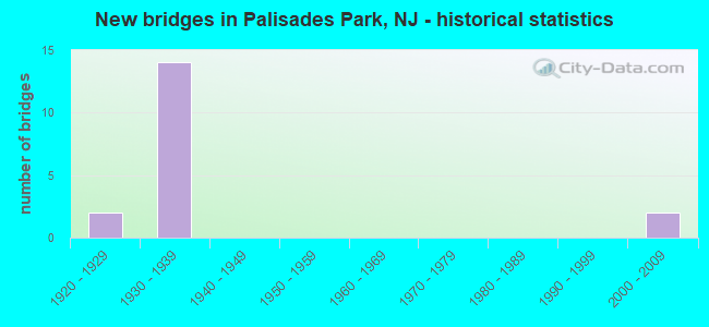
- New bridges - historical statistics
- 21920-1929
- 141930-1939
- 22000-2009

- Reconstructed bridges - Historical Statistics
- 11980-1989
- 51990-1999
- 12000-2009
- 12010-2019


- Bridge Condition - Deck
- 22.2%Good
- 77.8%Satisfactory

- Bridge Condition - Superstructure
- 33.3%Very good
- 22.2%Good
- 44.4%Satisfactory

- Bridge Condition - Substructure
- 22.2%Good
- 66.7%Satisfactory
- 11.1%Fair
Find on map >> Show street view
Structure Number: 20215, Location: 2.4 miles south of GWB (Lat: 40.842411, Lng: -73.994439), Route carried "on" structure: US 1, Year Built: 1930, Year Reconstructed: 1994, Status: Open, Structure Length: 1.74m (5.71ft), Average Daily Traffic: 41,150 (year 2020), Truck Traffic: 4%, Average Future Daily Traffic: 49,380 (year 2040), Design Load: HS 20+Mod, Features Intersected: EAST HOMESTEAD AVENUE
Minimum Vertical Clearance: 30+ m (98+ ft), Kilometerpoint: 101.662, Lanes on structure: 5, Lanes under structure: 2, Base Highway Network: Yes, Owner: State Highway Agency, Approaching Roadway Width: 22.9m (75.1ft), Skew: 30 degrees, Material/Design: Steel, Design/Construction: Stringer/Multi-beam, Number Of Spans In Main Unit: 1, Length of Maximum Span: 15.8m (51.8ft), Curb-To-Curb Width: 22.9m (75.1ft), Out-to-Out Width: 24.1m (79.1ft)
Condition: Deck: Satisfactory, Superstructure: Good, Substructure: Satisfactory, Operating Rating: 63.5 metric tons, Method Used To Determine Operating Rating: Load Factor (LF), Inventory Rating: 38.1 metric tons, Method Used To Determine Inventory Rating: Load Factor (LF), Structural Evaluation: Equal to present minimum criteria, Deck Geometry: Equal to present minimum criteria, Underclear: High priority of corrective action, Approach Roadway Alignment: Equal to present desirable criteria, Length Of Structure Improvement: 2.41m (7.91ft), Designated Inspection Frequency: Every 24 months, Inspection Date: Febuary 2020, Roadway Improvement Cost: $95,000, Total Project Cost: $109,000 ( Estimate for 2020), Deck Structure Type: Concrete Cast-file-Place, Wearing Surface/Protective System: Wearing Surface: Latex Concrete, Deck Protection: Epoxy Coated Reinforcing
Find on map >> Show street view
Structure Number: 202151, Location: 2.2 miles south of GWB (Lat: 40.843700, Lng: -73.993089), Route carried "on" structure: US 1, Year Built: 1930, Year Reconstructed: 1995, Status: Open, Structure Length: 2.56m (8.40ft), Average Daily Traffic: 41,150 (year 2020), Truck Traffic: 4%, Average Future Daily Traffic: 49,380 (year 2040), Design Load: HS 25 or greater, Features Intersected: EAST BRINCKERHOFF AVENUE
Minimum Vertical Clearance: 30+ m (98+ ft), Kilometerpoint: 101.855, Lanes on structure: 5, Lanes under structure: 2, Base Highway Network: Yes, Owner: State Highway Agency, Approaching Roadway Width: 23.2m (76.1ft), Skew: 30 degrees, Material/Design: Steel, Design/Construction: Girder and Floorbeam System, Number Of Spans In Main Unit: 1, Length of Maximum Span: 23.8m (78.1ft), Curb or Sidewalk Widths: Left: 1.8m (5.9ft), Right: 1.8m (5.9ft), Curb-To-Curb Width: 17.7m (58.1ft), Out-to-Out Width: 18.9m (62.0ft)
Condition: Deck: Satisfactory, Superstructure: Satisfactory, Substructure: Good, Operating Rating: 85.3 metric tons, Method Used To Determine Operating Rating: Load Factor (LF), Inventory Rating: 50.8 metric tons, Method Used To Determine Inventory Rating: Load Factor (LF), Structural Evaluation: Equal to present minimum criteria, Deck Geometry: High priority of replacement, Underclear: Meets minimum limits, Approach Roadway Alignment: Equal to present desirable criteria, Length Of Structure Improvement: 3.35m (10.99ft), Designated Inspection Frequency: Every 24 months, Critical Feature Inspection Frequency: Every 24 months, Inspection Date: Febuary 2020, Critical Feature Inspection Date: Febuary 2020, Bridge Improvement Cost: $3,873,000, Roadway Improvement Cost: $387,000, Total Project Cost: $5,570,000 ( Estimate for 2020), Deck Structure Type: Concrete Cast-file-Place, Wearing Surface/Protective System: Wearing Surface: Latex Concrete, Deck Protection: Epoxy Coated Reinforcing
Find on map >> Show street view
Structure Number: 202152, Location: 2.1 miles south of GWB (Lat: 40.844861, Lng: -73.991931), Route carried "on" structure: US 1, Year Built: 1930, Year Reconstructed: 1995, Status: Open, Structure Length: 2.56m (8.40ft), Average Daily Traffic: 41,150 (year 2020), Truck Traffic: 4%, Average Future Daily Traffic: 49,380 (year 2040), Design Load: HS 25 or greater, Features Intersected: EAST CENTRAL BLVD(RT501)
Minimum Vertical Clearance: 30+ m (98+ ft), Kilometerpoint: 102.016, Lanes on structure: 5, Lanes under structure: 2, Base Highway Network: Yes, Owner: State Highway Agency, Approaching Roadway Width: 23.2m (76.1ft), Skew: 30 degrees, Material/Design: Steel, Design/Construction: Girder and Floorbeam System, Number Of Spans In Main Unit: 1, Length of Maximum Span: 23.8m (78.1ft), Curb or Sidewalk Widths: Left: 1.8m (5.9ft), Right: 1.8m (5.9ft), Curb-To-Curb Width: 17.7m (58.1ft), Out-to-Out Width: 18.9m (62.0ft)
Condition: Deck: Satisfactory, Superstructure: Satisfactory, Substructure: Satisfactory, Operating Rating: 85.3 metric tons, Method Used To Determine Operating Rating: Load Factor (LF), Inventory Rating: 50.8 metric tons, Method Used To Determine Inventory Rating: Load Factor (LF), Structural Evaluation: Equal to present minimum criteria, Deck Geometry: High priority of replacement, Underclear: Better than present minimum criteria, Approach Roadway Alignment: Equal to present desirable criteria, Length Of Structure Improvement: 3.35m (10.99ft), Designated Inspection Frequency: Every 24 months, Critical Feature Inspection Frequency: Every 24 months, Inspection Date: March 2020, Critical Feature Inspection Date: March 2020, Bridge Improvement Cost: $3,873,000, Roadway Improvement Cost: $387,000, Total Project Cost: $5,570,000 ( Estimate for 2020), Deck Structure Type: Concrete Cast-file-Place, Wearing Surface/Protective System: Wearing Surface: Latex Concrete, Deck Protection: Epoxy Coated Reinforcing
Find on map >> Show street view
Structure Number: 202153, Location: 2.1 miles south of GWB (Lat: 40.846250, Lng: -73.990561), Route carried "on" structure: US 1, Year Built: 1930, Year Reconstructed: 1995, Status: Open, Structure Length: 2.56m (8.40ft), Average Daily Traffic: 41,150 (year 2020), Truck Traffic: 4%, Average Future Daily Traffic: 49,380 (year 2040), Design Load: HS 25 or greater, Features Intersected: EAST PALISADES BOULEVARD
Minimum Vertical Clearance: 30+ m (98+ ft), Kilometerpoint: 102.209, Lanes on structure: 5, Lanes under structure: 2, Base Highway Network: Yes, Owner: State Highway Agency, Approaching Roadway Width: 23.2m (76.1ft), Skew: 30 degrees, Material/Design: Steel, Design/Construction: Girder and Floorbeam System, Number Of Spans In Main Unit: 1, Length of Maximum Span: 23.8m (78.1ft), Curb or Sidewalk Widths: Left: 1.8m (5.9ft), Right: 1.8m (5.9ft), Curb-To-Curb Width: 17.7m (58.1ft), Out-to-Out Width: 18.9m (62.0ft)
Condition: Deck: Satisfactory, Superstructure: Good, Substructure: Satisfactory, Operating Rating: 85.3 metric tons, Method Used To Determine Operating Rating: Load Factor (LF), Inventory Rating: 50.8 metric tons, Method Used To Determine Inventory Rating: Load Factor (LF), Structural Evaluation: Equal to present minimum criteria, Deck Geometry: High priority of replacement, Underclear: Superior to present desirable criteria, Approach Roadway Alignment: Equal to present desirable criteria, Length Of Structure Improvement: 3.35m (10.99ft), Designated Inspection Frequency: Every 24 months, Critical Feature Inspection Frequency: Every 24 months, Inspection Date: March 2020, Critical Feature Inspection Date: March 2020, Bridge Improvement Cost: $2,807,000, Roadway Improvement Cost: $281,000, Total Project Cost: $4,579,000 ( Estimate for 2020), Deck Structure Type: Concrete Cast-file-Place, Wearing Surface/Protective System: Wearing Surface: Latex Concrete
Find on map >> Show street view
Structure Number: 202154, Location: 1.9 miles south of GWB (Lat: 40.848561, Lng: -73.988239), Route carried "on" structure: US 1, Year Built: 1930, Year Reconstructed: 1995, Status: Open, Structure Length: 2.56m (8.40ft), Average Daily Traffic: 41,150 (year 2020), Truck Traffic: 4%, Average Future Daily Traffic: 49,380 (year 2040), Design Load: HS 25 or greater, Features Intersected: EAST EDSALL BOULEVARD
Minimum Vertical Clearance: 30+ m (98+ ft), Kilometerpoint: 102.531, Lanes on structure: 5, Lanes under structure: 2, Base Highway Network: Yes, Owner: State Highway Agency, Approaching Roadway Width: 23.2m (76.1ft), Skew: 30 degrees, Material/Design: Steel, Design/Construction: Girder and Floorbeam System, Number Of Spans In Main Unit: 1, Length of Maximum Span: 23.8m (78.1ft), Curb or Sidewalk Widths: Left: 1.8m (5.9ft), Right: 1.8m (5.9ft), Curb-To-Curb Width: 17.7m (58.1ft), Out-to-Out Width: 18.9m (62.0ft)
Condition: Deck: Satisfactory, Superstructure: Satisfactory, Substructure: Satisfactory, Operating Rating: 85.3 metric tons, Method Used To Determine Operating Rating: Load Factor (LF), Inventory Rating: 50.8 metric tons, Method Used To Determine Inventory Rating: Load Factor (LF), Structural Evaluation: Equal to present minimum criteria, Deck Geometry: High priority of replacement, Underclear: High priority of replacement, Approach Roadway Alignment: Equal to present desirable criteria, Length Of Structure Improvement: 3.35m (10.99ft), Designated Inspection Frequency: Every 24 months, Critical Feature Inspection Frequency: Every 24 months, Inspection Date: March 2020, Critical Feature Inspection Date: March 2020, Bridge Improvement Cost: $3,742,000, Roadway Improvement Cost: $374,000, Total Project Cost: $5,940,000 ( Estimate for 2020), Deck Structure Type: Concrete Cast-file-Place, Wearing Surface/Protective System: Wearing Surface: Latex Concrete, Deck Protection: Epoxy Coated Reinforcing
Find on map >> Show street view
Structure Number: 202155, Location: 1.8 MI WEST OF GWB (Lat: 40.850081, Lng: -73.986689), Route carried "on" structure: US 1, Year Built: 1930, Year Reconstructed: 1995, Status: Open, Structure Length: 1.74m (5.71ft), Average Daily Traffic: 41,150 (year 2020), Truck Traffic: 4%, Average Future Daily Traffic: 50,203 (year 2040), Design Load: HS 25 or greater, Features Intersected: OAKDENE AVENUE
Minimum Vertical Clearance: 30.45m (99.90ft), Kilometerpoint: 102.741, Lanes on structure: 5, Lanes under structure: 2, Base Highway Network: Yes, Owner: State Highway Agency, Approaching Roadway Width: 22.3m (73.2ft), Skew: 30 degrees, Material/Design: Steel, Design/Construction: Stringer/Multi-beam, Number Of Spans In Main Unit: 1, Length of Maximum Span: 15.8m (51.8ft), Curb-To-Curb Width: 22.3m (73.2ft), Out-to-Out Width: 24.1m (79.1ft)
Condition: Deck: Satisfactory, Superstructure: Satisfactory, Substructure: Fair, Operating Rating: 49.9 metric tons, Method Used To Determine Operating Rating: Load Factor (LF), Inventory Rating: 29.9 metric tons, Method Used To Determine Inventory Rating: Load Factor (LF), Structural Evaluation: Somewhat better than minimum adequacy, Deck Geometry: Equal to present minimum criteria, Underclear: High priority of corrective action, Approach Roadway Alignment: Equal to present desirable criteria, Length Of Structure Improvement: 1.74m (5.71ft), Designated Inspection Frequency: Every 24 months, Inspection Date: April 2020, Roadway Improvement Cost: $1,000, Total Project Cost: $1,000 ( Estimate for 2020), Deck Structure Type: Concrete Cast-file-Place, Wearing Surface/Protective System: Wearing Surface: Latex Concrete, Deck Protection: Epoxy Coated Reinforcing
Find on map >> Show street view
Structure Number: 20715, Location: 0.44 MI WEST OF NJ 63 (Lat: 40.840631, Lng: -73.995050), Route carried "on" structure: State highway 5, Year Built: 2009, Status: Open, Structure Length: 1.98m (6.50ft), Average Daily Traffic: 15,740 (year 2021), Truck Traffic: 4%, Average Future Daily Traffic: 18,890 (year 2041), Design Load: HL 93, Features Intersected: DELIA BOULEVARD
Minimum Vertical Clearance: 30+ m (98+ ft), Kilometerpoint: 0.772, Lanes on structure: 3, Lanes under structure: 2, Base Highway Network: Yes, Owner: State Highway Agency, Approaching Roadway Width: 15.5m (50.9ft), Skew: 1 degrees, Material/Design: Steel, Design/Construction: Stringer/Multi-beam, Number Of Spans In Main Unit: 1, Length of Maximum Span: 18.3m (60.0ft), Curb or Sidewalk Widths: Left: 2.4m (7.9ft), Right: 2.4m (7.9ft), Curb-To-Curb Width: 15.5m (50.9ft), Out-to-Out Width: 21.0m (68.9ft)
Condition: Deck: Good, Superstructure: Very good, Substructure: Good, Operating Rating: 63.2 metric tons, Method Used To Determine Operating Rating: Load and Resistance Factor Rating (LRFR) rating reported by rating factor(RF) method using HL-93 loadings, Inventory Rating: 48.6 metric tons, Method Used To Determine Inventory Rating: Load and Resistance Factor Rating (LRFR) rating reported by rating factor(RF) method using HL-93 loadings, Structural Evaluation: Better than present minimum criteria, Deck Geometry: Equal to present minimum criteria, Underclear: Equal to present minimum criteria, Approach Roadway Alignment: Better than present minimum criteria, Designated Inspection Frequency: Every 24 months, Inspection Date: March 2021, Deck Structure Type: Concrete Cast-file-Place, Wearing Surface/Protective System: Deck Protection: Epoxy Coated Reinforcing
Find on map >> Show street view
Structure Number: 222153, Location: 0.83 MI EAST OF NJTPK JCT (Lat: 40.842831, Lng: -74.001400), Route carried "on" structure: US 1, Year Built: 1929, Year Reconstructed: 2014, Status: Open, Structure Length: 1.89m (6.20ft), Average Daily Traffic: 36,600 (year 2021), Truck Traffic: 4%, Average Future Daily Traffic: 43,900 (year 2041), Design Load: HL 93, Features Intersected: US 46, Facility Carried by Structure: BROAD AVENUE
Minimum Vertical Clearance: 30+ m (98+ ft), Kilometerpoint: 101.067, Lanes on structure: 4, Lanes under structure: 4, Base Highway Network: Yes, Owner: State Highway Agency, Approaching Roadway Width: 20.5m (67.3ft), Skew: 1 degrees, Material/Design: Prestressed concrete, Design/Construction: Stringer/Multi-beam, Number Of Spans In Main Unit: 1, Length of Maximum Span: 17.4m (57.1ft), Curb or Sidewalk Widths: Left: 1.8m (5.9ft), Right: 1.8m (5.9ft), Curb-To-Curb Width: 20.5m (67.3ft), Out-to-Out Width: 25.0m (82.0ft)
Condition: Deck: Good, Superstructure: Very good, Substructure: Satisfactory, Operating Rating: 84.9 metric tons, Method Used To Determine Operating Rating: Load and Resistance Factor Rating (LRFR) rating reported by rating factor(RF) method using HL-93 loadings, Inventory Rating: 65.4 metric tons, Method Used To Determine Inventory Rating: Load and Resistance Factor Rating (LRFR) rating reported by rating factor(RF) method using HL-93 loadings, Structural Evaluation: Equal to present minimum criteria, Deck Geometry: Superior to present desirable criteria, Underclear: High priority of corrective action, Approach Roadway Alignment: Better than present minimum criteria, Designated Inspection Frequency: Every 24 months, Inspection Date: September 2021, Deck Structure Type: Concrete Cast-file-Place, Wearing Surface/Protective System: Wearing Surface: Monolithic Concrete
Find on map >> Show street view
Structure Number: 222154, Location: 0.7MI.E.OF OVERPECK CREEK (Lat: 40.841711, Lng: -73.999339), Route carried "on" structure: City street , Year Built: 1931, Year Reconstructed: 2010, Status: Open, Structure Length: 1.83m (6.00ft), Average Daily Traffic: 2,480 (year 2021), Truck Traffic: 3%, Average Future Daily Traffic: 2,980 (year 2041), Design Load: HL 93, Features Intersected: US 46, Facility Carried by Structure: ROFF AVE.
Minimum Vertical Clearance: 30+ m (98+ ft), Kilometerpoint: 0.209, Lanes on structure: 2, Lanes under structure: 4, Owner: State Highway Agency, Approaching Roadway Width: 9.1m (29.9ft), Skew: 1 degrees, Material/Design: Prestressed concrete, Design/Construction: Box Beam or Girders - Multiple, Number Of Spans In Main Unit: 1, Length of Maximum Span: 17.7m (58.1ft), Curb or Sidewalk Widths: Left: 1.9m (6.2ft), Right: 1.9m (6.2ft), Curb-To-Curb Width: 9.1m (29.9ft), Out-to-Out Width: 13.8m (45.3ft)
Condition: Deck: Satisfactory, Superstructure: Very good, Substructure: Satisfactory, Operating Rating: 96.9 metric tons, Method Used To Determine Operating Rating: Load and Resistance Factor Rating (LRFR) rating reported by rating factor(RF) method using HL-93 loadings, Inventory Rating: 96.9 metric tons, Method Used To Determine Inventory Rating: Load and Resistance Factor Rating (LRFR) rating reported by rating factor(RF) method using HL-93 loadings, Structural Evaluation: Equal to present minimum criteria, Deck Geometry: Meets minimum limits, Underclear: High priority of corrective action, Approach Roadway Alignment: Better than present minimum criteria, Designated Inspection Frequency: Every 24 months, Inspection Date: September 2021, Deck Structure Type: Concrete Cast-file-Place, Wearing Surface/Protective System: Deck Protection: Epoxy Coated Reinforcing
Find on map >> Show street view
Structure Number: 20215, Location: 2.4 miles south of GWB (Lat: 40.842411, Lng: -73.994439), Route carried "under" structure: City street , Year Built: 1930, Structure Length: 0. m, Average Daily Traffic: 7,892 (year 2020), Truck Traffic: 1%, Features Intersected: EAST HOMESTEAD AVENUE, Facility Carried by Structure: US 1 & 9, US 46
Minimum Vertical Clearance: 4.29m (14.07ft), Kilometerpoint: 0.000, Lanes on structure: 5, Lanes under structure: 2, Material/Design: Steel, Design/Construction: Stringer/Multi-beam, Length of Maximum Span: 15.8m (51.8ft)
Find on map >> Show street view
Structure Number: 202151, Location: 2.2 miles south of GWB (Lat: 40.843700, Lng: -73.993089), Route carried "under" structure: City street , Year Built: 1930, Structure Length: 0. m, Average Daily Traffic: 2,696 (year 2020), Truck Traffic: 1%, Features Intersected: EAST BRINCKERHOFF AVENUE, Facility Carried by Structure: US 1 & 9, US 46
Minimum Vertical Clearance: 4.27m (14.01ft), Kilometerpoint: 0.000, Lanes on structure: 5, Lanes under structure: 2, Material/Design: Steel, Design/Construction: Girder and Floorbeam System, Length of Maximum Span: 23.8m (78.1ft)
Find on map >> Show street view
Structure Number: 202152, Location: 2.1 miles south of GWB (Lat: 40.844861, Lng: -73.991931), Route carried "under" structure: County highway 501, Year Built: 1930, Structure Length: 0. m, Average Daily Traffic: 10,056 (year 2020), Truck Traffic: 4%, Features Intersected: EAST CENTRAL BLVD(RT501), Facility Carried by Structure: US 1 & 9, US 46
Minimum Vertical Clearance: 6.04m (19.82ft), Kilometerpoint: 64.213, Lanes on structure: 5, Lanes under structure: 2, Material/Design: Steel, Design/Construction: Girder and Floorbeam System, Length of Maximum Span: 23.8m (78.1ft)
Find on map >> Show street view
Structure Number: 202153, Location: 2.1 miles south of GWB (Lat: 40.846250, Lng: -73.990561), Route carried "under" structure: City street , Year Built: 1930, Structure Length: 0. m, Average Daily Traffic: 7,318 (year 2020), Truck Traffic: 1%, Features Intersected: EAST PALISADES BOULEVARD, Facility Carried by Structure: US 1 & 9, US 46
Minimum Vertical Clearance: 5.41m (17.75ft), Kilometerpoint: 0.000, Lanes on structure: 5, Lanes under structure: 2, Material/Design: Steel, Design/Construction: Girder and Floorbeam System, Length of Maximum Span: 23.8m (78.1ft)
Find on map >> Show street view
Structure Number: 202154, Location: 1.9 miles south of GWB (Lat: 40.848561, Lng: -73.988239), Route carried "under" structure: City street , Year Built: 1930, Structure Length: 0. m, Average Daily Traffic: 9,028 (year 2020), Truck Traffic: 1%, Features Intersected: EAST EDSALL BOULEVARD, Facility Carried by Structure: US 1 & 9, US 46
Minimum Vertical Clearance: 4.19m (13.75ft), Kilometerpoint: 0.000, Lanes on structure: 5, Lanes under structure: 2, Material/Design: Steel, Design/Construction: Girder and Floorbeam System, Length of Maximum Span: 23.8m (78.1ft)
Find on map >> Show street view
Structure Number: 202155, Location: 1.8 MI WEST OF GWB (Lat: 40.850081, Lng: -73.986689), Route carried "under" structure: City street , Year Built: 1930, Structure Length: 0. m, Average Daily Traffic: 6,195 (year 2020), Truck Traffic: 1%, Features Intersected: OAKDENE AVENUE, Facility Carried by Structure: US 1, 9 & 46
Minimum Vertical Clearance: 4.32m (14.17ft), Kilometerpoint: 0.000, Lanes on structure: 5, Lanes under structure: 2, Material/Design: Steel, Design/Construction: Stringer/Multi-beam, Length of Maximum Span: 15.8m (51.8ft)
Find on map >> Show street view
Structure Number: 20715, Location: 0.44 MI WEST OF NJ 63 (Lat: 40.840631, Lng: -73.995050), Route carried "under" structure: City street , Year Built: 2009, Structure Length: 0. m, Average Daily Traffic: 360 (year 2021), Truck Traffic: 1%, Features Intersected: DELIA BOULEVARD, Facility Carried by Structure: NJ 5
Minimum Vertical Clearance: 4.72m (15.49ft), Kilometerpoint: 0.000, Lanes on structure: 3, Lanes under structure: 2, Material/Design: Steel, Design/Construction: Stringer/Multi-beam, Length of Maximum Span: 18.3m (60.0ft)
Find on map >> Show street view
Structure Number: 222153, Location: 0.83 MI EAST OF NJTPK JCT (Lat: 40.842831, Lng: -74.001400), Route carried "under" structure: US 46, Year Built: 1929, Structure Length: 0. m, Average Daily Traffic: 54,400 (year 2021), Truck Traffic: 4%, Features Intersected: US 46, Facility Carried by Structure: BROAD AVENUE
Minimum Vertical Clearance: 4.80m (15.75ft), Kilometerpoint: 115.615, Lanes on structure: 4, Lanes under structure: 4, Material/Design: Prestressed concrete, Design/Construction: Stringer/Multi-beam, Length of Maximum Span: 17.4m (57.1ft)
Find on map >> Show street view
Structure Number: 222154, Location: 0.7MI.E.OF OVERPECK CREEK (Lat: 40.841711, Lng: -73.999339), Route carried "under" structure: US 46, Year Built: 1931, Structure Length: 0. m, Average Daily Traffic: 54,400 (year 2021), Truck Traffic: 4%, Features Intersected: US 46, Facility Carried by Structure: ROFF AVE.
Minimum Vertical Clearance: 4.97m (16.31ft), Kilometerpoint: 115.841, Lanes on structure: 2, Lanes under structure: 4, Material/Design: Prestressed concrete, Design/Construction: Box Beam or Girders - Multiple, Length of Maximum Span: 17.7m (58.1ft)