Bridge Statistics for Overland, Missouri (MO)
Condition, Traffic, Stress, Structural Evaluation, Project Costs
- National Bridge Inventory (NBI) Statistics
- 19Number of bridges
- 187ft / 56.5mTotal length
- $1,961,000Total costs
- 743,571Total average daily traffic
- 35,091Total average daily truck traffic
- National Bridge Inventory (NBI) Registered Bridges for Overland
- No street view available for this location
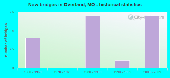
- New bridges - historical statistics
- 41960-1969
- 71980-1989
- 11990-1999
- 72000-2009
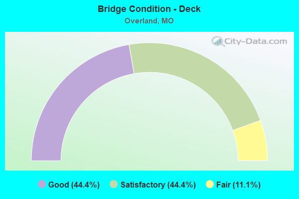
- Bridge Condition - Deck
- 44.4%Good
- 44.4%Satisfactory
- 11.1%Fair
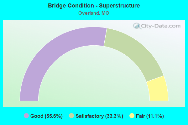
- Bridge Condition - Superstructure
- 55.6%Good
- 33.3%Satisfactory
- 11.1%Fair
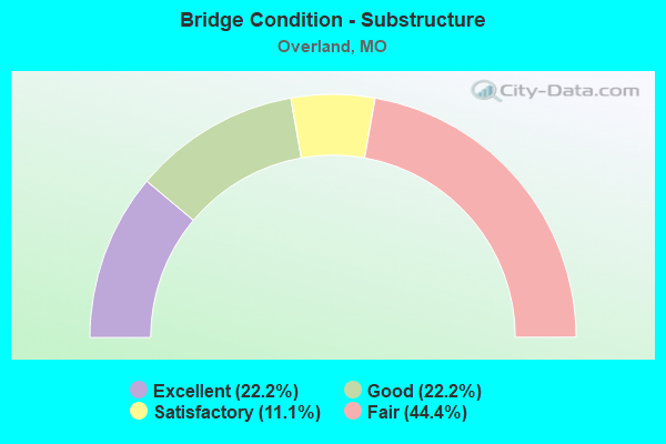
- Bridge Condition - Substructure
- 22.2%Excellent
- 22.2%Good
- 11.1%Satisfactory
- 44.4%Fair
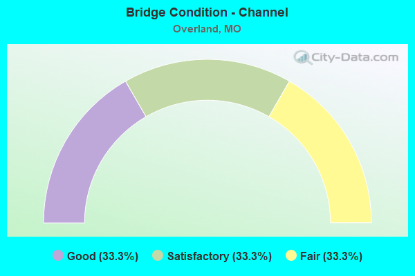
- Bridge Condition - Channel
- 33.3%Good
- 33.3%Satisfactory
- 33.3%Fair
Find on map >> Show street view
Structure Number: 15574, Location: S 30 T 46 N R 6 E (Lat: 38.703533, Lng: -90.390394), Route carried "on" structure: County highway , Year Built: 1993, Status: Posted for load, Structure Length: 2.41m (7.91ft), Average Daily Traffic: 14,413 (year 2020), Truck Traffic: 5%, Average Future Daily Traffic: 19,458 (year 2040), Design Load: HS 20, Features Intersected: MIDLAND BLVD, Facility Carried by Structure: ASHBY RD
Minimum Vertical Clearance: 30+ m (98+ ft), Kilometerpoint: 0.000, Lanes on structure: 6, Lanes under structure: 2, Owner: County Highway Agency, Approaching Roadway Width: 23.2m (76.1ft), Skew: 1 degrees, Material/Design: Prestressed concrete, Design/Construction: Stringer/Multi-beam, Number Of Spans In Main Unit: 1, Length of Maximum Span: 22.6m (74.1ft), Curb or Sidewalk Widths: Left: 1.5m (4.9ft), Right: 1.5m (4.9ft), Curb-To-Curb Width: 23.2m (76.1ft), Out-to-Out Width: 24.0m (78.7ft)
Condition: Deck: Satisfactory, Superstructure: Good, Substructure: Good, Operating Rating: 89.1 metric tons, Method Used To Determine Operating Rating: Allowable Stress (AS), Inventory Rating: 63.0 metric tons, Method Used To Determine Inventory Rating: Allowable Stress (AS), Structural Evaluation: Better than present minimum criteria, Deck Geometry: Meets minimum limits, Underclear: Meets minimum limits, Approach Roadway Alignment: Equal to present desirable criteria, Designated Inspection Frequency: Every 24 months, Inspection Date: April 2020, Deck Structure Type: Concrete Cast-file-Place, Wearing Surface/Protective System: Wearing Surface: Monolithic Concrete, Membrane: Epoxy, Deck Protection: Epoxy Coated Reinforcing
Find on map >> Show street view
Structure Number: 2423, Location: S 32 T 46 N R 6 E (Lat: 38.680978, Lng: -90.357128), Route carried "on" structure: Interstate 170, Year Built: 1968, Year Reconstructed: 1983, Status: Open, Structure Length: 4.02m (13.19ft), Average Daily Traffic: 97,230 (year 2021), Truck Traffic: 4%, Average Future Daily Traffic: 121,538 (year 2041), Design Load: HS 20+Mod, Features Intersected: CST WOODSON RD
Minimum Vertical Clearance: 30+ m (98+ ft), Kilometerpoint: 11.610, Lanes on structure: 6, Lanes under structure: 3, Base Highway Network: Yes, Owner: State Highway Agency, Approaching Roadway Width: 34.1m (111.9ft), Skew: 11 degrees, Material/Design: Steel, Design/Construction: Stringer/Multi-beam, Number Of Spans In Main Unit: 3, Length of Maximum Span: 21.5m (70.5ft), Curb-To-Curb Width: 32.6m (107.0ft), Out-to-Out Width: 33.4m (109.6ft)
Condition: Deck: Satisfactory, Superstructure: Satisfactory, Substructure: Fair, Operating Rating: 60.3 metric tons, Method Used To Determine Operating Rating: Load Factor (LF), Inventory Rating: 36.0 metric tons, Method Used To Determine Inventory Rating: Load Factor (LF), Structural Evaluation: Somewhat better than minimum adequacy, Deck Geometry: Superior to present desirable criteria, Underclear: High priority of corrective action, Approach Roadway Alignment: Equal to present desirable criteria, Length Of Structure Improvement: 0.50m (1.64ft), Designated Inspection Frequency: Every 24 months, Inspection Date: October 2020, Bridge Improvement Cost: $1,057,000, Roadway Improvement Cost: $106,000, Total Project Cost: $1,586,000 ( Estimate for 2022), Deck Structure Type: Concrete Cast-file-Place, Wearing Surface/Protective System: Wearing Surface: Epoxy Overlay, Deck Protection: Epoxy Coated Reinforcing
Find on map >> Show street view
Structure Number: 2424, Location: S 29 T 46 N R 6 E (Lat: 38.681386, Lng: -90.356572), Route carried "on" structure: Interstate 170, Year Built: 1968, Status: Open, Structure Length: 1.71m (5.61ft), Average Daily Traffic: 97,230 (year 2021), Truck Traffic: 4%, Average Future Daily Traffic: 121,538 (year 2041), Design Load: HS 20+Mod, Features Intersected: RVR DES PERES
Minimum Vertical Clearance: 30+ m (98+ ft), Kilometerpoint: 11.558, Lanes on structure: 6, Base Highway Network: Yes, Owner: State Highway Agency, Approaching Roadway Width: 32.9m (107.9ft), Skew: 23 degrees, Material/Design: Concrete continuous, Design/Construction: Culvert, Number Of Spans In Main Unit: 3, Length of Maximum Span: 4.6m (15.1ft)
Condition: Channel: Fair, Culverts: Poor, Operating Rating: 72.0 metric tons, Method Used To Determine Operating Rating: Field evaluation and documented engineering judgment, Inventory Rating: 43.2 metric tons, Method Used To Determine Inventory Rating: Field evaluation and documented engineering judgment, Structural Evaluation: Meets minimum limits, Waterway Adequacy: Equal to present desirable criteria, Approach Roadway Alignment: Equal to present minimum criteria, Length Of Structure Improvement: 0.24m (0.79ft), Designated Inspection Frequency: Every 24 months, Inspection Date: November 2021, Bridge Improvement Cost: $250,000, Roadway Improvement Cost: $25,000, Total Project Cost: $375,000 ( Estimate for 2022)
Find on map >> Show street view
Structure Number: 2425, Location: S 2914 T 46 N R 6 E (Lat: 38.684050, Lng: -90.354431), Route carried "on" structure: Interstate 170, Year Built: 1968, Year Reconstructed: 1983, Status: Open, Structure Length: 5.03m (16.50ft), Average Daily Traffic: 97,230 (year 2021), Truck Traffic: 4%, Average Future Daily Traffic: 121,538 (year 2041), Design Load: HS 20+Mod, Features Intersected: UP RR
Minimum Vertical Clearance: 30+ m (98+ ft), Kilometerpoint: 11.187, Lanes on structure: 6, Base Highway Network: Yes, Owner: State Highway Agency, Approaching Roadway Width: 34.1m (111.9ft), Skew: 10 degrees, Material/Design: Steel, Design/Construction: Stringer/Multi-beam, Number Of Spans In Main Unit: 3, Length of Maximum Span: 19.8m (65.0ft), Curb-To-Curb Width: 34.8m (114.2ft), Out-to-Out Width: 35.6m (116.8ft)
Condition: Deck: Good, Superstructure: Satisfactory, Substructure: Satisfactory, Operating Rating: 62.1 metric tons, Method Used To Determine Operating Rating: Load Factor (LF), Inventory Rating: 36.9 metric tons, Method Used To Determine Inventory Rating: Load Factor (LF), Structural Evaluation: Equal to present minimum criteria, Deck Geometry: Superior to present desirable criteria, Underclear: Somewhat better than minimum adequacy, Approach Roadway Alignment: Equal to present desirable criteria, Designated Inspection Frequency: Every 24 months, Inspection Date: October 2020, Deck Structure Type: Concrete Cast-file-Place, Wearing Surface/Protective System: Wearing Surface: Epoxy Overlay, Deck Protection: Epoxy Coated Reinforcing
Find on map >> Show street view
Structure Number: 2717, Location: S 28 T 46 N R 6 E (Lat: 38.698353, Lng: -90.345114), Route carried "on" structure: City street , Year Built: 1981, Status: Open, Structure Length: 7.96m (26.12ft), Average Daily Traffic: 7,975 (year 2021), Truck Traffic: 7%, Average Future Daily Traffic: 11,165 (year 2041), Design Load: HS 20+Mod, Features Intersected: IS 170, Facility Carried by Structure: MIDLAND BLVD E
Minimum Vertical Clearance: 30+ m (98+ ft), Kilometerpoint: 6.225, Lanes on structure: 5, Lanes under structure: 8, Owner: State Highway Agency, Approaching Roadway Width: 27.0m (88.6ft), Skew: 21 degrees, Material/Design: Steel continuous, Design/Construction: Stringer/Multi-beam, Number Of Spans In Main Unit: 3, Length of Maximum Span: 29.6m (97.1ft), Curb or Sidewalk Widths: Left: 0.4m (1.3ft), Right: 0.4m (1.3ft), Curb-To-Curb Width: 27.0m (88.6ft), Out-to-Out Width: 27.8m (91.2ft)
Condition: Deck: Fair, Superstructure: Fair, Substructure: Fair, Operating Rating: 56.7 metric tons, Method Used To Determine Operating Rating: Load Factor (LF), Inventory Rating: 34.2 metric tons, Method Used To Determine Inventory Rating: Load Factor (LF), Structural Evaluation: Somewhat better than minimum adequacy, Deck Geometry: Superior to present desirable criteria, Underclear: Equal to present minimum criteria, Approach Roadway Alignment: Equal to present desirable criteria, Designated Inspection Frequency: Every 24 months, Inspection Date: September 2020, Deck Structure Type: Concrete Cast-file-Place, Wearing Surface/Protective System: Wearing Surface: Monolithic Concrete, Deck Protection: Epoxy Coated Reinforcing
Find on map >> Show street view
Structure Number: 2718, Location: S 33 T 46 N R 6 E (Lat: 38.686467, Lng: -90.354164), Route carried "on" structure: Interstate 170, Year Built: 1980, Status: Open, Structure Length: 5.55m (18.21ft), Average Daily Traffic: 94,535 (year 2021), Truck Traffic: 4%, Average Future Daily Traffic: 118,169 (year 2041), Design Load: HS 20+Mod, Features Intersected: RT D
Minimum Vertical Clearance: 30+ m (98+ ft), Kilometerpoint: 10.918, Lanes on structure: 6, Lanes under structure: 6, Base Highway Network: Yes, Owner: State Highway Agency, Approaching Roadway Width: 32.9m (107.9ft), Skew: 20 degrees, Material/Design: Steel continuous, Design/Construction: Stringer/Multi-beam, Number Of Spans In Main Unit: 3, Length of Maximum Span: 29.9m (98.1ft), Curb or Sidewalk Widths: Left: 0.2m (0.7ft), Right: 0.2m (0.7ft), Curb-To-Curb Width: 32.8m (107.6ft), Out-to-Out Width: 33.8m (110.9ft)
Condition: Deck: Satisfactory, Superstructure: Satisfactory, Substructure: Fair, Operating Rating: 62.1 metric tons, Method Used To Determine Operating Rating: Load Factor (LF), Inventory Rating: 36.9 metric tons, Method Used To Determine Inventory Rating: Load Factor (LF), Structural Evaluation: Somewhat better than minimum adequacy, Deck Geometry: Superior to present desirable criteria, Underclear: Meets minimum limits, Approach Roadway Alignment: Equal to present desirable criteria, Designated Inspection Frequency: Every 24 months, Inspection Date: October 2020, Deck Structure Type: Concrete Cast-file-Place, Wearing Surface/Protective System: Wearing Surface: Monolithic Concrete, Deck Protection: Epoxy Coated Reinforcing
Find on map >> Show street view
Structure Number: 31528, Location: S 5 T 45 N R 6 E (Lat: 38.674111, Lng: -90.362036), Route carried "on" structure: Interstate 170, Year Built: 2006, Status: Open, Structure Length: 6.34m (20.80ft), Average Daily Traffic: 52,090 (year 2021), Truck Traffic: 6%, Average Future Daily Traffic: 65,113 (year 2041), Design Load: HS 25 or greater, Features Intersected: MO 340, RP MO340E TO IS1
Minimum Vertical Clearance: 30+ m (98+ ft), Kilometerpoint: 5.337, Lanes on structure: 3, Lanes under structure: 11, Base Highway Network: Yes, Owner: State Highway Agency, Approaching Roadway Width: 16.0m (52.5ft), Material/Design: Steel, Design/Construction: Stringer/Multi-beam, Number Of Spans In Main Unit: 1, Length of Maximum Span: 63.4m (208.0ft), Curb-To-Curb Width: 16.0m (52.5ft), Out-to-Out Width: 16.8m (55.1ft)
Condition: Deck: Good, Superstructure: Good, Substructure: Excellent, Operating Rating: 77.4 metric tons, Method Used To Determine Operating Rating: Load Factor (LF), Inventory Rating: 46.8 metric tons, Method Used To Determine Inventory Rating: Load Factor (LF), Structural Evaluation: Better than present minimum criteria, Deck Geometry: Equal to present minimum criteria, Underclear: Superior to present desirable criteria, Approach Roadway Alignment: Equal to present desirable criteria, Designated Inspection Frequency: Every 24 months, Inspection Date: October 2020, Deck Structure Type: Concrete Cast-file-Place, Wearing Surface/Protective System: Wearing Surface: Monolithic Concrete, Deck Protection: Epoxy Coated Reinforcing
Find on map >> Show street view
Structure Number: 31529, Location: S 5 T 45 N R 6 E (Lat: 38.674111, Lng: -90.362219), Route carried "on" structure: Interstate 170, Year Built: 2006, Status: Open, Structure Length: 6.34m (20.80ft), Average Daily Traffic: 61,832 (year 2021), Truck Traffic: 4%, Average Future Daily Traffic: 77,290 (year 2041), Design Load: HS 25 or greater, Features Intersected: MO 340, RP IS170E TO MO3
Minimum Vertical Clearance: 30+ m (98+ ft), Kilometerpoint: 12.505, Lanes on structure: 3, Lanes under structure: 11, Base Highway Network: Yes, Owner: State Highway Agency, Approaching Roadway Width: 16.0m (52.5ft), Material/Design: Steel, Design/Construction: Stringer/Multi-beam, Number Of Spans In Main Unit: 1, Length of Maximum Span: 63.4m (208.0ft), Curb-To-Curb Width: 16.0m (52.5ft), Out-to-Out Width: 16.8m (55.1ft)
Condition: Deck: Good, Superstructure: Good, Substructure: Excellent, Operating Rating: 79.2 metric tons, Method Used To Determine Operating Rating: Load Factor (LF), Inventory Rating: 47.7 metric tons, Method Used To Determine Inventory Rating: Load Factor (LF), Structural Evaluation: Better than present minimum criteria, Deck Geometry: Equal to present minimum criteria, Underclear: Superior to present desirable criteria, Approach Roadway Alignment: Equal to present desirable criteria, Designated Inspection Frequency: Every 24 months, Inspection Date: October 2020, Deck Structure Type: Concrete Cast-file-Place, Wearing Surface/Protective System: Wearing Surface: Monolithic Concrete, Deck Protection: Epoxy Coated Reinforcing
Find on map >> Show street view
Structure Number: 3204, Location: S 13 T 58 N R 6 W (Lat: 39.819789, Lng: -91.514219), Route carried "on" structure: US 24, Year Built: 1983, Status: Open, Structure Length: 15.73m (51.61ft), Average Daily Traffic: 6,603 (year 2021), Truck Traffic: 28%, Average Future Daily Traffic: 12,546 (year 2041), Design Load: HS 20+Mod, Features Intersected: NORTH RVR
Minimum Vertical Clearance: 30+ m (98+ ft), Kilometerpoint: 21.742, Lanes on structure: 2, Base Highway Network: Yes, Owner: State Highway Agency, Approaching Roadway Width: 12.2m (40.0ft), Skew: 2 degrees, Material/Design: Steel continuous, Design/Construction: Stringer/Multi-beam, Number Of Spans In Main Unit: 3, Number Of Approach Spans: 4, Length of Maximum Span: 36.6m (120.1ft), Curb-To-Curb Width: 12.0m (39.4ft), Out-to-Out Width: 12.8m (42.0ft)
Condition: Deck: Satisfactory, Superstructure: Good, Substructure: Fair, Channel: Satisfactory, Operating Rating: 60.3 metric tons, Method Used To Determine Operating Rating: Load Factor (LF), Inventory Rating: 34.2 metric tons, Method Used To Determine Inventory Rating: Load Factor (LF), Structural Evaluation: Somewhat better than minimum adequacy, Deck Geometry: Better than present minimum criteria, Waterway Adequacy: Equal to present desirable criteria, Approach Roadway Alignment: Equal to present desirable criteria, Designated Inspection Frequency: Every 24 months, Inspection Date: January 2021, Deck Structure Type: Concrete Cast-file-Place, Wearing Surface/Protective System: Wearing Surface: Bituminous, Deck Protection: Epoxy Coated Reinforcing
Find on map >> Show street view
Structure Number: 3204, Location: S 32 T 46 N R 6 E (Lat: 38.681475, Lng: -90.357564), Route carried "on" structure: County highway , Year Built: 2009, Status: Open, Structure Length: 1.42m (4.66ft), Average Daily Traffic: 8,563 (year 2020), Truck Traffic: 10%, Average Future Daily Traffic: 11,560 (year 2040), Design Load: HS 25 or greater, Features Intersected: RVR DES PERES, Facility Carried by Structure: WOODSON RD
Minimum Vertical Clearance: 30+ m (98+ ft), Kilometerpoint: 0.000, Lanes on structure: 4, Owner: County Highway Agency, Approaching Roadway Width: 15.8m (51.8ft), Skew: 3 degrees, Material/Design: Steel, Design/Construction: Stringer/Multi-beam, Number Of Spans In Main Unit: 1, Length of Maximum Span: 13.0m (42.7ft), Curb or Sidewalk Widths: Left: 1.8m (5.9ft), Right: 1.8m (5.9ft), Curb-To-Curb Width: 15.8m (51.8ft), Out-to-Out Width: 20.2m (66.3ft)
Condition: Deck: Good, Superstructure: Good, Substructure: Good, Channel: Good, Inventory Rating: 76.5 metric tons, Method Used To Determine Inventory Rating: Load Factor (LF), Structural Evaluation: Better than present minimum criteria, Deck Geometry: Meets minimum limits, Waterway Adequacy: Superior to present desirable criteria, Approach Roadway Alignment: Equal to present minimum criteria, Designated Inspection Frequency: Every 24 months, Inspection Date: March 2021, Deck Structure Type: Concrete Cast-file-Place, Wearing Surface/Protective System: Wearing Surface: Monolithic Concrete, Membrane: Other, Deck Protection: Epoxy Coated Reinforcing
Find on map >> Show street view
Structure Number: 2423, Location: S 32 T 46 N R 6 E (Lat: 38.680978, Lng: -90.357128), Route carried "under" structure: City street , Year Built: 1968, Structure Length: 0. m, Average Daily Traffic: 11,202 (year 2021), Truck Traffic: 5%, Features Intersected: CST WOODSON RD, Facility Carried by Structure: IS 170 E
Minimum Vertical Clearance: 4.65m (15.26ft), Kilometerpoint: 4.252, Lanes on structure: 6, Lanes under structure: 3, Material/Design: Steel, Design/Construction: Stringer/Multi-beam, Length of Maximum Span: 21.5m (70.5ft)
Find on map >> Show street view
Structure Number: 2717, Location: S 28 T 46 N R 6 E (Lat: 38.698353, Lng: -90.345114), Route carried "under" structure: Interstate 170, Year Built: 1981, Structure Length: 0. m, Average Daily Traffic: 36,470 (year 2021), Truck Traffic: 6%, Features Intersected: IS 170, Facility Carried by Structure: MIDLAND BLVD E
Minimum Vertical Clearance: 5.08m (16.67ft), Kilometerpoint: 8.525, Lanes on structure: 5, Lanes under structure: 4, Material/Design: Steel continuous, Design/Construction: Stringer/Multi-beam, Length of Maximum Span: 29.6m (97.1ft)
Find on map >> Show street view
Structure Number: 2717, Location: S 28 T 46 N R 6 E (Lat: 38.698353, Lng: -90.345114), Route carried "under" structure: Interstate 170, Year Built: 1981, Structure Length: 0. m, Average Daily Traffic: 59,137 (year 2021), Truck Traffic: 4%, Features Intersected: IS 170, Facility Carried by Structure: MIDLAND BLVD E
Minimum Vertical Clearance: 5.11m (16.77ft), Kilometerpoint: 9.378, Lanes on structure: 5, Lanes under structure: 4, Material/Design: Steel continuous, Design/Construction: Stringer/Multi-beam, Length of Maximum Span: 29.6m (97.1ft)
Find on map >> Show street view
Structure Number: 2718, Location: S 33 T 46 N R 6 E (Lat: 38.686467, Lng: -90.354164), Route carried "under" structure: State highway D, Year Built: 1980, Structure Length: 0. m, Average Daily Traffic: 19,356 (year 2021), Truck Traffic: 5%, Features Intersected: RT D, Facility Carried by Structure: IS 170 E
Minimum Vertical Clearance: 4.98m (16.34ft), Kilometerpoint: 9.094, Lanes on structure: 6, Lanes under structure: 3, Material/Design: Steel continuous, Design/Construction: Stringer/Multi-beam, Length of Maximum Span: 29.9m (98.1ft)
Find on map >> Show street view
Structure Number: 2718, Location: S 33 T 46 N R 6 E (Lat: 38.686467, Lng: -90.354164), Route carried "under" structure: State highway D, Year Built: 1980, Structure Length: 0. m, Average Daily Traffic: 18,828 (year 2021), Truck Traffic: 5%, Features Intersected: RT D, Facility Carried by Structure: IS 170 E
Minimum Vertical Clearance: 4.90m (16.08ft), Kilometerpoint: 16.205, Lanes on structure: 6, Lanes under structure: 3, Material/Design: Steel continuous, Design/Construction: Stringer/Multi-beam, Length of Maximum Span: 29.9m (98.1ft)
Find on map >> Show street view
Structure Number: 31528, Location: S 5 T 45 N R 6 E (Lat: 38.674111, Lng: -90.362036), Route carried "under" structure: State highway 340, Year Built: 2006, Structure Length: 0. m, Average Daily Traffic: 19,455 (year 2021), Truck Traffic: 5%, Features Intersected: MO 340, Facility Carried by Structure: IS 170 W
Minimum Vertical Clearance: 5.11m (16.77ft), Kilometerpoint: 26.255, Lanes on structure: 3, Lanes under structure: 4, Material/Design: Steel, Design/Construction: Stringer/Multi-beam, Length of Maximum Span: 63.4m (208.0ft)
Find on map >> Show street view
Structure Number: 31528, Location: S 5 T 45 N R 6 E (Lat: 38.674111, Lng: -90.362036), Route carried "under" structure: State highway 340, Year Built: 2006, Structure Length: 0. m, Average Daily Traffic: 8,322 (year 2021), Truck Traffic: 5%, Features Intersected: MO 340, Facility Carried by Structure: IS 170 W
Minimum Vertical Clearance: 5.11m (16.77ft), Kilometerpoint: 4.765, Lanes on structure: 3, Lanes under structure: 3, Material/Design: Steel, Design/Construction: Stringer/Multi-beam, Length of Maximum Span: 63.4m (208.0ft)
Find on map >> Show street view
Structure Number: 31529, Location: S 5 T 45 N R 6 E (Lat: 38.674111, Lng: -90.362219), Route carried "under" structure: State highway 340, Year Built: 2006, Structure Length: 0. m, Average Daily Traffic: 19,455 (year 2021), Truck Traffic: 5%, Features Intersected: MO 340, Facility Carried by Structure: IS 170 E
Minimum Vertical Clearance: 5.16m (16.93ft), Kilometerpoint: 26.240, Lanes on structure: 3, Lanes under structure: 4, Material/Design: Steel, Design/Construction: Stringer/Multi-beam, Length of Maximum Span: 63.4m (208.0ft)
Find on map >> Show street view
Structure Number: 31529, Location: S 5 T 45 N R 6 E (Lat: 38.674111, Lng: -90.362219), Route carried "under" structure: State highway 340, Year Built: 2006, Structure Length: 0. m, Average Daily Traffic: 13,645 (year 2021), Truck Traffic: 5%, Features Intersected: MO 340, Facility Carried by Structure: IS 170 E
Minimum Vertical Clearance: 5.16m (16.93ft), Kilometerpoint: 4.780, Lanes on structure: 3, Lanes under structure: 3, Material/Design: Steel, Design/Construction: Stringer/Multi-beam, Length of Maximum Span: 63.4m (208.0ft)