Bridge Statistics for Otsego, Minnesota (MN)
Condition, Traffic, Stress, Structural Evaluation, Project Costs
- National Bridge Inventory (NBI) Statistics
- 29Number of bridges
- 456ft / 139mTotal length
- $1,000Total costs
- 364,682Total average daily traffic
- 17,826Total average daily truck traffic
- National Bridge Inventory (NBI) Registered Bridges for Otsego
- No street view available for this location
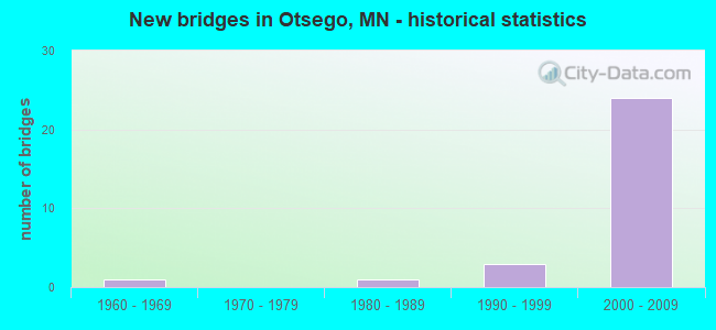
- New bridges - historical statistics
- 11960-1969
- 11980-1989
- 31990-1999
- 242000-2009


- Bridge Condition - Deck
- 7.1%Very good
- 85.7%Good
- 7.1%Satisfactory

- Bridge Condition - Superstructure
- 21.4%Very good
- 71.4%Good
- 7.1%Fair

- Bridge Condition - Substructure
- 7.1%Very good
- 64.3%Good
- 14.3%Satisfactory
- 14.3%Fair

- Bridge Condition - Channel
- 11.1%Good
- 77.8%Satisfactory
- 11.1%Fair
Find on map >> Show street view
Structure Number: 27019, Location: 2.4 MI N OF JCT TH 94 (Lat: 45.227075, Lng: -93.552667), Route carried "on" structure: State highway 101, Year Built: 1993, Status: Open, Structure Length: 7.92m (25.98ft), Average Daily Traffic: 24,500 (year 2019), Truck Traffic: 6%, Average Future Daily Traffic: 23,750 (year 2039), Design Load: HS 25 or greater, Features Intersected: Crow River
Minimum Vertical Clearance: 30+ m (98+ ft), Kilometerpoint: 0.000, Lanes on structure: 2, Base Highway Network: Yes, Owner: State Highway Agency, Approaching Roadway Width: 13.7m (44.9ft), Material/Design: Prestressed concrete, Design/Construction: Stringer/Multi-beam, Number Of Spans In Main Unit: 3, Length of Maximum Span: 30.5m (100.1ft), Curb-To-Curb Width: 13.2m (43.3ft), Out-to-Out Width: 14.2m (46.6ft)
Condition: Deck: Good, Superstructure: Good, Substructure: Good, Channel: Satisfactory, Operating Rating: 69.6 metric tons, Method Used To Determine Operating Rating: Load Factor (LF), Inventory Rating: 42.4 metric tons, Method Used To Determine Inventory Rating: Load Factor (LF), Structural Evaluation: Better than present minimum criteria, Deck Geometry: Superior to present desirable criteria, Waterway Adequacy: Equal to present desirable criteria, Approach Roadway Alignment: Equal to present desirable criteria, Designated Inspection Frequency: Every 24 months, Underwater Inspection Frequency: Every 60 months, Inspection Date: June 2021, Underwater Inspection Date: August 2020, Deck Structure Type: Concrete Cast-file-Place, Wearing Surface/Protective System: Wearing Surface: Epoxy Overlay, Deck Protection: Epoxy Coated Reinforcing
Find on map >> Show street view
Structure Number: 2702, Location: 2.4 MI N OF JCT TH 94 (Lat: 45.226997, Lng: -93.552322), Route carried "on" structure: State highway 101, Year Built: 1967, Status: Open, Structure Length: 7.94m (26.05ft), Average Daily Traffic: 24,500 (year 2019), Truck Traffic: 6%, Average Future Daily Traffic: 23,750 (year 2039), Design Load: HS 20, Features Intersected: Crow River
Minimum Vertical Clearance: 30+ m (98+ ft), Kilometerpoint: 0.000, Lanes on structure: 2, Base Highway Network: Yes, Owner: State Highway Agency, Approaching Roadway Width: 13.4m (44.0ft), Material/Design: Steel continuous, Design/Construction: Stringer/Multi-beam, Number Of Spans In Main Unit: 3, Length of Maximum Span: 30.5m (100.1ft), Curb-To-Curb Width: 9.9m (32.5ft), Out-to-Out Width: 10.9m (35.8ft)
Condition: Deck: Satisfactory, Superstructure: Fair, Substructure: Satisfactory, Channel: Satisfactory, Operating Rating: 53.2 metric tons, Method Used To Determine Operating Rating: Load Factor (LF), Inventory Rating: 31.7 metric tons, Method Used To Determine Inventory Rating: Load Factor (LF), Structural Evaluation: Somewhat better than minimum adequacy, Deck Geometry: Meets minimum limits, Waterway Adequacy: Equal to present desirable criteria, Approach Roadway Alignment: Equal to present desirable criteria, Designated Inspection Frequency: Every 24 months, Underwater Inspection Frequency: Every 60 months, Inspection Date: June 2021, Underwater Inspection Date: August 2020, Deck Structure Type: Concrete Cast-file-Place, Wearing Surface/Protective System: Wearing Surface: Low Slump Concrete
Find on map >> Show street view
Structure Number: 86005, Location: 0.2 MI S OF JCT TH 10 (Lat: 45.288853, Lng: -93.558333), Route carried "on" structure: State highway 101, Year Built: 1993, Status: Open, Structure Length: 21.54m (70.67ft), Average Daily Traffic: 26,000 (year 2014), Truck Traffic: 6%, Average Future Daily Traffic: 26,000 (year 2039), Design Load: HS 25 or greater, Features Intersected: Mississippi River
Minimum Vertical Clearance: 30+ m (98+ ft), Kilometerpoint: 0.000, Lanes on structure: 2, Base Highway Network: Yes, Owner: State Highway Agency, Approaching Roadway Width: 11.6m (38.1ft), Skew: 1 degrees, Material/Design: Prestressed concrete, Design/Construction: Stringer/Multi-beam, Number Of Spans In Main Unit: 5, Length of Maximum Span: 45.7m (149.9ft), Curb-To-Curb Width: 12.8m (42.0ft), Out-to-Out Width: 13.8m (45.3ft)
Condition: Deck: Good, Superstructure: Good, Substructure: Fair, Channel: Satisfactory, Operating Rating: 94.7 metric tons, Method Used To Determine Operating Rating: Load Factor (LF), Inventory Rating: 66.9 metric tons, Method Used To Determine Inventory Rating: Load Factor (LF), Structural Evaluation: Somewhat better than minimum adequacy, Deck Geometry: Equal to present desirable criteria, Waterway Adequacy: Equal to present desirable criteria, Approach Roadway Alignment: Equal to present desirable criteria, Designated Inspection Frequency: Every 24 months, Underwater Inspection Frequency: Every 60 months, Inspection Date: June 2021, Underwater Inspection Date: September 2021, Deck Structure Type: Concrete Cast-file-Place, Wearing Surface/Protective System: Wearing Surface: Epoxy Overlay, Deck Protection: Epoxy Coated Reinforcing
Find on map >> Show street view
Structure Number: 86005A, Location: 0.2 MI S OF JCT TH 10 (Lat: 45.289683, Lng: -93.557442), Route carried "on" structure: Ramp State highway 64, Year Built: 1993, Status: Open, Structure Length: 8.92m (29.27ft), Average Daily Traffic: 1,000 (year 1990), Average Future Daily Traffic: 1,000 (year 2029), Design Load: HS 25 or greater, Features Intersected: Mississippi River
Minimum Vertical Clearance: 30+ m (98+ ft), Kilometerpoint: 0.000, Lanes on structure: 2, Base Highway Network: Yes, Owner: State Highway Agency, Approaching Roadway Width: 7.9m (25.9ft), Skew: 2 degrees, Material/Design: Prestressed concrete, Design/Construction: Stringer/Multi-beam, Number Of Spans In Main Unit: 2, Length of Maximum Span: 47.4m (155.5ft), Curb-To-Curb Width: 8.8m (28.9ft), Out-to-Out Width: 9.8m (32.2ft)
Condition: Deck: Good, Superstructure: Good, Substructure: Good, Channel: Satisfactory, Operating Rating: 94.7 metric tons, Method Used To Determine Operating Rating: Load Factor (LF), Inventory Rating: 66.9 metric tons, Method Used To Determine Inventory Rating: Load Factor (LF), Structural Evaluation: Better than present minimum criteria, Deck Geometry: Meets minimum limits, Waterway Adequacy: Equal to present desirable criteria, Approach Roadway Alignment: Better than present minimum criteria, Designated Inspection Frequency: Every 24 months, Inspection Date: June 2021, Deck Structure Type: Concrete Cast-file-Place, Wearing Surface/Protective System: Wearing Surface: Epoxy Overlay, Deck Protection: Epoxy Coated Reinforcing
Find on map >> Show street view
Structure Number: 86006, Location: 0.2 mi S of jct TH 10 (Lat: 45.288656, Lng: -93.558197), Route carried "on" structure: State highway 101, Year Built: 2001, Status: Open, Structure Length: 21.51m (70.57ft), Average Daily Traffic: 26,925 (year 2019), Truck Traffic: 6%, Average Future Daily Traffic: 26,000 (year 2039), Design Load: HL 93, Features Intersected: NB/Mississippi River
Minimum Vertical Clearance: 30+ m (98+ ft), Kilometerpoint: 0.000, Lanes on structure: 3, Base Highway Network: Yes, Owner: State Highway Agency, Approaching Roadway Width: 16.5m (54.1ft), Skew: 1 degrees, Material/Design: Prestressed concrete, Design/Construction: Stringer/Multi-beam, Number Of Spans In Main Unit: 5, Length of Maximum Span: 45.7m (149.9ft), Curb-To-Curb Width: 16.5m (54.1ft), Out-to-Out Width: 17.5m (57.4ft)
Condition: Deck: Good, Superstructure: Good, Substructure: Satisfactory, Channel: Satisfactory, Operating Rating: 90.5 metric tons, Method Used To Determine Operating Rating: Load Factor (LF), Inventory Rating: 37.4 metric tons, Method Used To Determine Inventory Rating: Load Factor (LF), Structural Evaluation: Equal to present minimum criteria, Deck Geometry: Better than present minimum criteria, Waterway Adequacy: Equal to present desirable criteria, Approach Roadway Alignment: Equal to present desirable criteria, Designated Inspection Frequency: Every 24 months, Underwater Inspection Frequency: Every 60 months, Inspection Date: June 2021, Underwater Inspection Date: September 2021, Deck Structure Type: Concrete Cast-file-Place, Wearing Surface/Protective System: Wearing Surface: Epoxy Overlay, Deck Protection: Epoxy Coated Reinforcing
Find on map >> Show street view
Structure Number: 86013, Location: 2.6 MI N OF JCT TH 94 (Lat: 45.229339, Lng: -93.552458), Route carried "on" structure: County highway 36, Year Built: 2006, Status: Open, Structure Length: 5.88m (19.29ft), Average Daily Traffic: 2,200 (year 2016), Average Future Daily Traffic: 2,200 (year 2039), Design Load: HL 93, Features Intersected: TH 101
Minimum Vertical Clearance: 30+ m (98+ ft), Kilometerpoint: 0.000, Lanes on structure: 4, Lanes under structure: 6, Owner: State Highway Agency, Approaching Roadway Width: 29.9m (98.1ft), Skew: 21 degrees, Material/Design: Prestressed concrete, Design/Construction: Stringer/Multi-beam, Number Of Spans In Main Unit: 2, Length of Maximum Span: 28.7m (94.2ft), Curb or Sidewalk Widths: Left: 0.0m, Right: 3.0m (9.8ft), Curb-To-Curb Width: 31.7m (104.0ft), Out-to-Out Width: 37.4m (122.7ft)
Condition: Deck: Good, Superstructure: Very good, Substructure: Good, Operating Rating: 64.5 metric tons, Method Used To Determine Operating Rating: Load Factor (LF), Inventory Rating: 37.7 metric tons, Method Used To Determine Inventory Rating: Load Factor (LF), Structural Evaluation: Better than present minimum criteria, Deck Geometry: Superior to present desirable criteria, Underclear: Equal to present minimum criteria, Approach Roadway Alignment: Equal to present desirable criteria, Designated Inspection Frequency: Every 24 months, Inspection Date: October 2020, Deck Structure Type: Concrete Cast-file-Place, Wearing Surface/Protective System: Wearing Surface: Epoxy Overlay, Deck Protection: Epoxy Coated Reinforcing
Find on map >> Show street view
Structure Number: 86014, Location: 2.8 MI S JCT TH 169; 10 (Lat: 45.252411, Lng: -93.555236), Route carried "on" structure: County highway 38, Year Built: 2006, Status: Open, Structure Length: 7.31m (23.98ft), Average Daily Traffic: 1,150 (year 2016), Average Future Daily Traffic: 1,150 (year 2039), Design Load: HL 93, Features Intersected: TH 101
Minimum Vertical Clearance: 30+ m (98+ ft), Kilometerpoint: 0.000, Lanes on structure: 4, Lanes under structure: 5, Owner: State Highway Agency, Approaching Roadway Width: 29.9m (98.1ft), Skew: 20 degrees, Material/Design: Prestressed concrete, Design/Construction: Stringer/Multi-beam, Number Of Spans In Main Unit: 2, Length of Maximum Span: 38.1m (125.0ft), Curb or Sidewalk Widths: Left: 3.0m (9.8ft), Right: 0.0m, Curb-To-Curb Width: 29.9m (98.1ft), Out-to-Out Width: 36.1m (118.4ft)
Condition: Deck: Good, Superstructure: Good, Substructure: Good, Operating Rating: 82.9 metric tons, Method Used To Determine Operating Rating: Load Factor (LF), Inventory Rating: 41.5 metric tons, Method Used To Determine Inventory Rating: Load Factor (LF), Structural Evaluation: Better than present minimum criteria, Deck Geometry: Superior to present desirable criteria, Underclear: Better than present minimum criteria, Approach Roadway Alignment: Equal to present desirable criteria, Designated Inspection Frequency: Every 24 months, Inspection Date: October 2020, Deck Structure Type: Concrete Cast-file-Place, Wearing Surface/Protective System: Wearing Surface: Low Slump Concrete, Deck Protection: Epoxy Coated Reinforcing
Find on map >> Show street view
Structure Number: 86015, Location: 2.1 MI S OF JCT TH 169;10 (Lat: 45.263692, Lng: -93.555992), Route carried "on" structure: State highway 101, Year Built: 2006, Status: Open, Structure Length: 4.83m (15.85ft), Average Daily Traffic: 21,750 (year 2014), Truck Traffic: 6%, Average Future Daily Traffic: 21,750 (year 2039), Design Load: HL 93, Features Intersected: CSAH 42
Minimum Vertical Clearance: 30+ m (98+ ft), Kilometerpoint: 0.000, Lanes on structure: 2, Lanes under structure: 4, Base Highway Network: Yes, Owner: State Highway Agency, Approaching Roadway Width: 18.3m (60.0ft), Skew: 3 degrees, Material/Design: Prestressed concrete, Design/Construction: Stringer/Multi-beam, Number Of Spans In Main Unit: 1, Length of Maximum Span: 46.3m (151.9ft), Curb-To-Curb Width: 18.3m (60.0ft), Out-to-Out Width: 19.2m (63.0ft)
Condition: Deck: Good, Superstructure: Good, Substructure: Good, Operating Rating: 99.6 metric tons, Method Used To Determine Operating Rating: Load Factor (LF), Inventory Rating: 45.1 metric tons, Method Used To Determine Inventory Rating: Load Factor (LF), Structural Evaluation: Better than present minimum criteria, Deck Geometry: Superior to present desirable criteria, Underclear: Better than present minimum criteria, Approach Roadway Alignment: Equal to present desirable criteria, Designated Inspection Frequency: Every 24 months, Inspection Date: October 2020, Deck Structure Type: Concrete Cast-file-Place, Wearing Surface/Protective System: Wearing Surface: Monolithic Concrete, Deck Protection: Epoxy Coated Reinforcing
Find on map >> Show street view
Structure Number: 86016, Location: 2.1 MI S OF JCT TH169; 10 (Lat: 45.263731, Lng: -93.555722), Route carried "on" structure: State highway 101, Year Built: 2006, Status: Open, Structure Length: 4.83m (15.85ft), Average Daily Traffic: 22,524 (year 2019), Truck Traffic: 6%, Average Future Daily Traffic: 21,750 (year 2039), Design Load: HL 93, Features Intersected: CSAH 42
Minimum Vertical Clearance: 30+ m (98+ ft), Kilometerpoint: 0.000, Lanes on structure: 2, Lanes under structure: 4, Base Highway Network: Yes, Owner: State Highway Agency, Approaching Roadway Width: 18.3m (60.0ft), Skew: 3 degrees, Material/Design: Prestressed concrete, Design/Construction: Stringer/Multi-beam, Number Of Spans In Main Unit: 1, Length of Maximum Span: 46.3m (151.9ft), Curb-To-Curb Width: 18.3m (60.0ft), Out-to-Out Width: 19.2m (63.0ft)
Condition: Deck: Very good, Superstructure: Good, Substructure: Very good, Operating Rating: 99.6 metric tons, Method Used To Determine Operating Rating: Load Factor (LF), Inventory Rating: 45.1 metric tons, Method Used To Determine Inventory Rating: Load Factor (LF), Structural Evaluation: Better than present minimum criteria, Deck Geometry: Superior to present desirable criteria, Underclear: Better than present minimum criteria, Approach Roadway Alignment: Equal to present desirable criteria, Designated Inspection Frequency: Every 24 months, Inspection Date: October 2020, Deck Structure Type: Concrete Cast-file-Place, Wearing Surface/Protective System: Wearing Surface: Monolithic Concrete, Deck Protection: Epoxy Coated Reinforcing
Find on map >> Show street view
Structure Number: 86017, Location: 0.7 MI S OF JCT TH 169;10 (Lat: 45.281586, Lng: -93.561150), Route carried "on" structure: State highway 101, Year Built: 2007, Status: Open, Structure Length: 7.02m (23.03ft), Average Daily Traffic: 26,000 (year 2014), Truck Traffic: 6%, Average Future Daily Traffic: 26,000 (year 2039), Design Load: HL 93, Features Intersected: CSAH 39
Minimum Vertical Clearance: 5.79m (19.00ft), Kilometerpoint: 0.000, Lanes on structure: 2, Lanes under structure: 6, Base Highway Network: Yes, Owner: State Highway Agency, Approaching Roadway Width: 12.2m (40.0ft), Skew: 1 degrees, Material/Design: Steel continuous, Design/Construction: Stringer/Multi-beam, Number Of Spans In Main Unit: 1, Length of Maximum Span: 68.7m (225.4ft), Curb-To-Curb Width: 18.5m (60.7ft), Out-to-Out Width: 19.5m (64.0ft)
Condition: Deck: Good, Superstructure: Very good, Substructure: Good, Operating Rating: 65.1 metric tons, Method Used To Determine Operating Rating: Load Factor (LF), Inventory Rating: 39.0 metric tons, Method Used To Determine Inventory Rating: Load Factor (LF), Structural Evaluation: Better than present minimum criteria, Deck Geometry: Superior to present desirable criteria, Underclear: Superior to present desirable criteria, Approach Roadway Alignment: Equal to present desirable criteria, Length Of Structure Improvement: 2.35m (7.71ft), Designated Inspection Frequency: Every 24 months, Inspection Date: October 2020, Bridge Improvement Cost: $999,999,000, Roadway Improvement Cost: $1,000, Total Project Cost: $1,000, Deck Structure Type: Concrete Cast-file-Place, Wearing Surface/Protective System: Wearing Surface: Low Slump Concrete, Deck Protection: Epoxy Coated Reinforcing
Find on map >> Show street view
Structure Number: 86018, Location: 0.7 MI S of jct th 169;10 (Lat: 45.281533, Lng: -93.560897), Route carried "on" structure: State highway 101, Year Built: 2007, Status: Open, Structure Length: 7.02m (23.03ft), Average Daily Traffic: 26,925 (year 2019), Truck Traffic: 6%, Average Future Daily Traffic: 26,000 (year 2039), Design Load: HL 93, Features Intersected: CSAH 39
Minimum Vertical Clearance: 30+ m (98+ ft), Kilometerpoint: 0.000, Lanes on structure: 2, Lanes under structure: 6, Base Highway Network: Yes, Owner: State Highway Agency, Approaching Roadway Width: 12.2m (40.0ft), Skew: 1 degrees, Material/Design: Steel continuous, Design/Construction: Stringer/Multi-beam, Number Of Spans In Main Unit: 1, Length of Maximum Span: 68.7m (225.4ft), Curb-To-Curb Width: 19.1m (62.7ft), Out-to-Out Width: 20.1m (65.9ft)
Condition: Deck: Good, Superstructure: Very good, Substructure: Good, Operating Rating: 65.1 metric tons, Method Used To Determine Operating Rating: Load Factor (LF), Inventory Rating: 39.0 metric tons, Method Used To Determine Inventory Rating: Load Factor (LF), Structural Evaluation: Better than present minimum criteria, Deck Geometry: Superior to present desirable criteria, Underclear: Superior to present desirable criteria, Approach Roadway Alignment: Equal to present desirable criteria, Designated Inspection Frequency: Every 24 months, Inspection Date: October 2020, Deck Structure Type: Concrete Cast-file-Place, Wearing Surface/Protective System: Wearing Surface: Low Slump Concrete, Deck Protection: Epoxy Coated Reinforcing
Find on map >> Show street view
Structure Number: 86019, Location: 2.7 MI N OF JCT TH 94 (Lat: 45.227006, Lng: -93.553008), Route carried "on" structure: Ramp State highway 6107, Year Built: 2006, Status: Open, Structure Length: 10.15m (33.30ft), Average Daily Traffic: 5,000 (year 2004), Average Future Daily Traffic: 7,600 (year 2026), Design Load: HL 93, Features Intersected: Crow River
Minimum Vertical Clearance: 30+ m (98+ ft), Kilometerpoint: 0.000, Lanes on structure: 1, Base Highway Network: Yes, Owner: State Highway Agency, Approaching Roadway Width: 7.9m (25.9ft), Material/Design: Prestressed concrete, Design/Construction: Stringer/Multi-beam, Number Of Spans In Main Unit: 3, Length of Maximum Span: 33.5m (109.9ft), Curb-To-Curb Width: 7.9m (25.9ft), Out-to-Out Width: 8.9m (29.2ft)
Condition: Deck: Good, Superstructure: Good, Substructure: Good, Channel: Satisfactory, Operating Rating: 89.4 metric tons, Method Used To Determine Operating Rating: Load Factor (LF), Inventory Rating: 44.4 metric tons, Method Used To Determine Inventory Rating: Load Factor (LF), Structural Evaluation: Better than present minimum criteria, Deck Geometry: Equal to present desirable criteria, Waterway Adequacy: Equal to present desirable criteria, Approach Roadway Alignment: Equal to present desirable criteria, Designated Inspection Frequency: Every 24 months, Underwater Inspection Frequency: Every 60 months, Inspection Date: June 2021, Underwater Inspection Date: September 2021, Deck Structure Type: Concrete Cast-file-Place, Wearing Surface/Protective System: Wearing Surface: Epoxy Overlay, Deck Protection: Epoxy Coated Reinforcing
Find on map >> Show street view
Structure Number: 8602, Location: 2.7 MI N OF JCT TH 94 (Lat: 45.226792, Lng: -93.551994), Route carried "on" structure: Ramp State highway 6106, Year Built: 2006, Status: Open, Structure Length: 9.44m (30.97ft), Average Daily Traffic: 5,000 (year 2004), Average Future Daily Traffic: 7,600 (year 2030), Design Load: HL 93, Features Intersected: Crow River
Minimum Vertical Clearance: 30+ m (98+ ft), Kilometerpoint: 0.000, Lanes on structure: 1, Base Highway Network: Yes, Owner: State Highway Agency, Approaching Roadway Width: 7.9m (25.9ft), Skew: 1 degrees, Material/Design: Prestressed concrete, Design/Construction: Stringer/Multi-beam, Number Of Spans In Main Unit: 3, Length of Maximum Span: 31.1m (102.0ft), Curb-To-Curb Width: 7.9m (25.9ft), Out-to-Out Width: 8.9m (29.2ft)
Condition: Deck: Good, Superstructure: Good, Substructure: Good, Channel: Satisfactory, Operating Rating: 79.4 metric tons, Method Used To Determine Operating Rating: Load Factor (LF), Inventory Rating: 39.5 metric tons, Method Used To Determine Inventory Rating: Load Factor (LF), Structural Evaluation: Better than present minimum criteria, Deck Geometry: Equal to present desirable criteria, Waterway Adequacy: Equal to present desirable criteria, Approach Roadway Alignment: Equal to present desirable criteria, Designated Inspection Frequency: Every 24 months, Underwater Inspection Frequency: Every 60 months, Inspection Date: June 2021, Underwater Inspection Date: September 2021, Deck Structure Type: Concrete Cast-file-Place, Wearing Surface/Protective System: Wearing Surface: Low Slump Concrete, Deck Protection: Epoxy Coated Reinforcing
Find on map >> Show street view
Structure Number: 86515, Location: 1.3 MI N OF JCT CSAH 39 (Lat: 45.301525, Lng: -93.565500), Route carried "on" structure: County highway 42, Year Built: 1984, Status: Posted for load, Structure Length: 13.72m (45.01ft), Average Daily Traffic: 7,300 (year 2016), Average Future Daily Traffic: 7,300 (year 2039), Design Load: HS 20, Features Intersected: MISSISSIPPI RIVER
Minimum Vertical Clearance: 30+ m (98+ ft), Kilometerpoint: 0.000, Lanes on structure: 2, Owner: County Highway Agency, Approaching Roadway Width: 14.0m (45.9ft), Material/Design: Prestressed concrete, Design/Construction: Stringer/Multi-beam, Number Of Spans In Main Unit: 4, Length of Maximum Span: 34.1m (111.9ft), Curb or Sidewalk Widths: Left: 1.8m (5.9ft), Right: 0.0m, Curb-To-Curb Width: 14.0m (45.9ft), Out-to-Out Width: 16.8m (55.1ft)
Condition: Deck: Good, Superstructure: Good, Substructure: Fair, Channel: Good, Operating Rating: 74.9 metric tons, Method Used To Determine Operating Rating: Load Factor (LF), Inventory Rating: 45.9 metric tons, Method Used To Determine Inventory Rating: Load Factor (LF), Structural Evaluation: Somewhat better than minimum adequacy, Deck Geometry: Superior to present desirable criteria, Waterway Adequacy: Equal to present desirable criteria, Approach Roadway Alignment: Equal to present desirable criteria, Designated Inspection Frequency: Every 24 months, Underwater Inspection Frequency: Every 60 months, Inspection Date: September 2021, Underwater Inspection Date: July 2020, Deck Structure Type: Concrete Cast-file-Place, Wearing Surface/Protective System: Wearing Surface: Low Slump Concrete, Deck Protection: Epoxy Coated Reinforcing
Find on map >> Show street view
Structure Number: 86X07, Location: .02 MI W OF JCT TH101 (Lat: 45.281436, Lng: -93.561644), Route carried "on" structure: ServiceCounty highway 39, Year Built: 2006, Status: Open, Structure Length: 0.65m (2.13ft), Average Daily Traffic: 11,300 (year 2008), Average Future Daily Traffic: 10,900 (year 2029), Design Load: HS 25 or greater, Features Intersected: STREAM
Minimum Vertical Clearance: 30+ m (98+ ft), Kilometerpoint: 0.000, Lanes on structure: 4, Owner: State Highway Agency, Approaching Roadway Width: 30.5m (100.1ft), Skew: 22 degrees, Material/Design: Concrete, Design/Construction: Culvert, Number Of Spans In Main Unit: 2, Length of Maximum Span: 2.7m (8.9ft)
Condition: Channel: Fair, Culverts: Very good, Operating Rating: 68.6 metric tons, Method Used To Determine Operating Rating: Assigned rating based on Load Factor Design (LFD) reported in metric tons, Inventory Rating: 40.8 metric tons, Method Used To Determine Inventory Rating: Assigned rating based on Load Factor Design (LFD) reported in metric tons, Structural Evaluation: Equal to present desirable criteria, Waterway Adequacy: Equal to present desirable criteria, Approach Roadway Alignment: Equal to present desirable criteria, Designated Inspection Frequency: Every 24 months, Inspection Date: October 2020
Find on map >> Show street view
Structure Number: 86013, Location: 2.6 MI N OF JCT TH 94 (Lat: 45.229339, Lng: -93.552458), Route carried "under" structure: State highway 101, Year Built: 2006, Structure Length: 0. m, Average Daily Traffic: 49,000 (year 2019), Truck Traffic: 6%, Features Intersected: TH 101, Facility Carried by Structure: CSAH 36
Minimum Vertical Clearance: 5.15m (16.90ft), Kilometerpoint: 0.000, Lanes on structure: 4, Lanes under structure: 6, Material/Design: Prestressed concrete, Design/Construction: Stringer/Multi-beam, Length of Maximum Span: 28.7m (94.2ft)
Find on map >> Show street view
Structure Number: 86014, Location: 2.8 MI S JCT TH 169; 10 (Lat: 45.252411, Lng: -93.555236), Route carried "under" structure: State highway 101, Year Built: 2006, Structure Length: 0. m, Average Daily Traffic: 49,000 (year 2019), Truck Traffic: 6%, Features Intersected: TH 101, Facility Carried by Structure: CSAH 38
Minimum Vertical Clearance: 5.27m (17.29ft), Kilometerpoint: 0.000, Lanes on structure: 4, Lanes under structure: 5, Material/Design: Prestressed concrete, Design/Construction: Stringer/Multi-beam, Length of Maximum Span: 38.1m (125.0ft)
Find on map >> Show street view
Structure Number: 86015, Location: 2.1 MI S OF JCT TH 169;10 (Lat: 45.263692, Lng: -93.555992), Route carried "under" structure: County highway 42, Year Built: 2006, Structure Length: 0. m, Average Daily Traffic: 6,400 (year 2004), Features Intersected: CSAH 42, Facility Carried by Structure: MN 101
Minimum Vertical Clearance: 5.03m (16.50ft), Kilometerpoint: 0.000, Lanes on structure: 2, Lanes under structure: 4, Material/Design: Prestressed concrete, Design/Construction: Stringer/Multi-beam, Length of Maximum Span: 46.3m (151.9ft)
Find on map >> Show street view
Structure Number: 86016, Location: 2.1 MI S OF JCT TH169; 10 (Lat: 45.263731, Lng: -93.555722), Route carried "under" structure: County highway 42, Year Built: 2006, Structure Length: 0. m, Average Daily Traffic: 6,400 (year 2004), Features Intersected: CSAH 42, Facility Carried by Structure: MN 101
Minimum Vertical Clearance: 5.18m (16.99ft), Kilometerpoint: 0.000, Lanes on structure: 2, Lanes under structure: 4, Material/Design: Prestressed concrete, Design/Construction: Stringer/Multi-beam, Length of Maximum Span: 46.3m (151.9ft)
Find on map >> Show street view
Structure Number: 86017, Location: 0.7 MI S OF JCT TH 169;10 (Lat: 45.281586, Lng: -93.561150), Route carried "under" structure: County highway 39, Year Built: 2007, Structure Length: 0. m, Average Daily Traffic: 10,900 (year 2004), Features Intersected: CSAH 39, Facility Carried by Structure: MN 101
Minimum Vertical Clearance: 5.79m (19.00ft), Kilometerpoint: 0.000, Lanes on structure: 2, Lanes under structure: 6, Material/Design: Steel continuous, Design/Construction: Stringer/Multi-beam, Length of Maximum Span: 68.7m (225.4ft)
Find on map >> Show street view
Structure Number: 86017, Location: 0.7 MI S OF JCT TH 169;10 (Lat: 45.281586, Lng: -93.561150), Route carried "under" structure: Ramp State highway 22, Year Built: 2007, Structure Length: 0. m, Average Daily Traffic: 1 (year 2021), Features Intersected: CSAH 39, Facility Carried by Structure: MN 101
Minimum Vertical Clearance: 5.79m (19.00ft), Kilometerpoint: 0.000, Lanes under structure: 1, Material/Design: Steel continuous, Design/Construction: Stringer/Multi-beam, Length of Maximum Span: 68.7m (225.4ft)
Find on map >> Show street view
Structure Number: 86017, Location: 0.7 MI S OF JCT TH 169;10 (Lat: 45.281586, Lng: -93.561150), Route carried "under" structure: Ramp State highway 21, Year Built: 2007, Structure Length: 0. m, Average Daily Traffic: 1 (year 2021), Features Intersected: CSAH 39, Facility Carried by Structure: MN 101
Minimum Vertical Clearance: 5.79m (19.00ft), Kilometerpoint: 0.000, Lanes under structure: 1, Material/Design: Steel continuous, Design/Construction: Stringer/Multi-beam, Length of Maximum Span: 68.7m (225.4ft)
Find on map >> Show street view
Structure Number: 86017, Location: 0.7 MI S OF JCT TH 169;10 (Lat: 45.281586, Lng: -93.561150), Route carried "under" structure: Ramp State highway 19, Year Built: 2007, Structure Length: 0. m, Average Daily Traffic: 1 (year 2021), Features Intersected: CSAH 39, Facility Carried by Structure: MN 101
Minimum Vertical Clearance: 5.79m (19.00ft), Kilometerpoint: 0.000, Lanes under structure: 1, Material/Design: Steel continuous, Design/Construction: Stringer/Multi-beam, Length of Maximum Span: 68.7m (225.4ft)
Find on map >> Show street view
Structure Number: 86017, Location: 0.7 MI S OF JCT TH 169;10 (Lat: 45.281586, Lng: -93.561150), Route carried "under" structure: Ramp State highway 20, Year Built: 2007, Structure Length: 0. m, Average Daily Traffic: 1 (year 2021), Features Intersected: CSAH 39, Facility Carried by Structure: MN 101
Minimum Vertical Clearance: 5.79m (19.00ft), Kilometerpoint: 0.000, Lanes under structure: 2, Material/Design: Steel continuous, Design/Construction: Stringer/Multi-beam, Length of Maximum Span: 68.7m (225.4ft)
Find on map >> Show street view
Structure Number: 86018, Location: 0.7 MI S of jct th 169;10 (Lat: 45.281533, Lng: -93.560897), Route carried "under" structure: County highway 39, Year Built: 2007, Structure Length: 0. m, Average Daily Traffic: 10,900 (year 2004), Features Intersected: CSAH 39, Facility Carried by Structure: MN 101
Minimum Vertical Clearance: 5.09m (16.70ft), Kilometerpoint: 0.000, Lanes on structure: 2, Lanes under structure: 6, Material/Design: Steel continuous, Design/Construction: Stringer/Multi-beam, Length of Maximum Span: 68.7m (225.4ft)
Find on map >> Show street view
Structure Number: 86018, Location: 0.7 MI S of jct th 169;10 (Lat: 45.281533, Lng: -93.560897), Route carried "under" structure: Ramp State highway 21, Year Built: 2007, Structure Length: 0. m, Average Daily Traffic: 1 (year 2021), Features Intersected: CSAH 39, Facility Carried by Structure: MN 101
Minimum Vertical Clearance: 5.12m (16.80ft), Kilometerpoint: 0.000, Lanes under structure: 1, Material/Design: Steel continuous, Design/Construction: Stringer/Multi-beam, Length of Maximum Span: 68.7m (225.4ft)
Find on map >> Show street view
Structure Number: 86018, Location: 0.7 MI S of jct th 169;10 (Lat: 45.281533, Lng: -93.560897), Route carried "under" structure: Ramp State highway 22, Year Built: 2007, Structure Length: 0. m, Average Daily Traffic: 1 (year 2021), Features Intersected: CSAH 39, Facility Carried by Structure: MN 101
Minimum Vertical Clearance: 5.12m (16.80ft), Kilometerpoint: 0.000, Lanes under structure: 2, Material/Design: Steel continuous, Design/Construction: Stringer/Multi-beam, Length of Maximum Span: 68.7m (225.4ft)
Find on map >> Show street view
Structure Number: 86018, Location: 0.7 MI S of jct th 169;10 (Lat: 45.281533, Lng: -93.560897), Route carried "under" structure: Ramp State highway 19, Year Built: 2007, Structure Length: 0. m, Average Daily Traffic: 1 (year 2021), Features Intersected: CSAH 39, Facility Carried by Structure: MN 101
Minimum Vertical Clearance: 5.36m (17.59ft), Kilometerpoint: 0.000, Lanes under structure: 1, Material/Design: Steel continuous, Design/Construction: Stringer/Multi-beam, Length of Maximum Span: 68.7m (225.4ft)
Find on map >> Show street view
Structure Number: 86018, Location: 0.7 MI S of jct th 169;10 (Lat: 45.281533, Lng: -93.560897), Route carried "under" structure: Ramp State highway 20, Year Built: 2007, Structure Length: 0. m, Average Daily Traffic: 1 (year 2021), Features Intersected: CSAH 39, Facility Carried by Structure: MN 101
Minimum Vertical Clearance: 5.36m (17.59ft), Kilometerpoint: 0.000, Lanes under structure: 2, Material/Design: Steel continuous, Design/Construction: Stringer/Multi-beam, Length of Maximum Span: 68.7m (225.4ft)