Bridge Statistics for Oregon City, Oregon (OR)
Condition, Traffic, Stress, Structural Evaluation, Project Costs
- National Bridge Inventory (NBI) Statistics
- 26Number of bridges
- 433ft / 132mTotal length
- $14,124,000Total costs
- 1,010,405Total average daily traffic
- 83,626Total average daily truck traffic
- National Bridge Inventory (NBI) Registered Bridges for Oregon City
- No street view available for this location
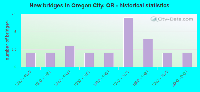
- New bridges - historical statistics
- 21920-1929
- 21930-1939
- 31940-1949
- 21950-1959
- 21960-1969
- 71970-1979
- 41980-1989
- 21990-1999
- 22000-2009

- Reconstructed bridges - Historical Statistics
- 11950-1959
- 31960-1969
- 01970-1979
- 11980-1989


- Bridge Condition - Deck
- 11.1%Good
- 83.3%Satisfactory
- 5.6%Fair

- Bridge Condition - Superstructure
- 27.8%Good
- 55.6%Satisfactory
- 11.1%Poor
- 5.6%Serious

- Bridge Condition - Substructure
- 16.7%Good
- 55.6%Satisfactory
- 27.8%Fair

- Bridge Condition - Channel
- 7.7%Excellent
- 7.7%Very good
- 15.4%Good
- 46.2%Satisfactory
- 23.1%Fair
Find on map >> Show street view
Structure Number: 357 003 01143, Location: 0.1 MI N OF MAIN ST (O C) (Lat: 45.358961, Lng: -122.609589), Route carried "on" structure: State highway 43, Year Built: 1922, Status: Posted for load, Structure Length: 23.32m (76.51ft), Average Daily Traffic: 11,862 (year 2020), Truck Traffic: 2%, Average Future Daily Traffic: 17,500 (year 2040), Design Load: H 15, Features Intersected: WILLAMETTE RIVER, Facility Carried by Structure: HWY 3
Minimum Vertical Clearance: 30+ m (98+ ft), Kilometerpoint: 18.395, Lanes on structure: 2, Lanes under structure: 5, Owner: State Highway Agency, Approaching Roadway Width: 5.6m (18.4ft), Navigation Control: Yes ( Vertical Clearance: 14.9m (48.9ft), Horizontal Clearance: 55.2m (181.1ft)), Material/Design: Steel, Design/Construction: Arch - Thru, Number Of Spans In Main Unit: 1, Number Of Approach Spans: 10, Length of Maximum Span: 103.6m (339.9ft), Curb or Sidewalk Widths: Left: 1.4m (4.6ft), Right: 1.4m (4.6ft), Curb-To-Curb Width: 5.6m (18.4ft), Out-to-Out Width: 9.3m (30.5ft)
Condition: Deck: Satisfactory, Superstructure: Satisfactory, Substructure: Satisfactory, Channel: Excellent, Operating Rating: 17.8 metric tons, Method Used To Determine Operating Rating: Load and Resistance Factor Rating (LRFR) rating reported by rating factor(RF) method using HL-93 loadings, Inventory Rating: 13.6 metric tons, Method Used To Determine Inventory Rating: Load and Resistance Factor Rating (LRFR) rating reported by rating factor(RF) method using HL-93 loadings, Structural Evaluation: High priority of replacement, Deck Geometry: High priority of replacement, Waterway Adequacy: Equal to present desirable criteria, Approach Roadway Alignment: Equal to present desirable criteria, Bridge Posting: Required (Relationship of Operating Rating to Maximum Legal Load: 30.0 - 39.9% below), Length Of Structure Improvement: 25.00m (82.02ft), Designated Inspection Frequency: Every 12 months, Underwater Inspection Frequency: Every 60 months, Inspection Date: December 2021, Underwater Inspection Date: September 2020, Bridge Improvement Cost: $2,603,000, Roadway Improvement Cost: $260,000, Total Project Cost: $4,164,000, Deck Structure Type: Concrete Cast-file-Place, Wearing Surface/Protective System: Wearing Surface: Latex Concrete
Find on map >> Show street view
Structure Number: 1214 018 01148, Location: 013 MI E HWY 213 (Lat: 45.360472, Lng: -122.573744), Route carried "on" structure: County highway 9640, Year Built: 1956, Year Reconstructed: 1967, Status: Open, Structure Length: 1.95m (6.40ft), Average Daily Traffic: 9,270 (year 2020), Truck Traffic: 13%, Average Future Daily Traffic: 9,405 (year 2025), Design Load: HS 20, Features Intersected: ABERNETHY CREEK, Facility Carried by Structure: REDLAND RD (W)
Minimum Vertical Clearance: 30+ m (98+ ft), Kilometerpoint: 18.282, Lanes on structure: 2, Owner: County Highway Agency, Approaching Roadway Width: 10.7m (35.1ft), Material/Design: Prestressed concrete, Design/Construction: Stringer/Multi-beam, Number Of Spans In Main Unit: 2, Length of Maximum Span: 9.8m (32.2ft), Curb-To-Curb Width: 9.1m (29.9ft), Out-to-Out Width: 10.1m (33.1ft)
Condition: Deck: Satisfactory, Superstructure: Satisfactory, Substructure: Fair, Channel: Fair, Operating Rating: 19.4 metric tons, Method Used To Determine Operating Rating: Load and Resistance Factor Rating (LRFR) rating reported by rating factor(RF) method using HL-93 loadings, Inventory Rating: 14.9 metric tons, Method Used To Determine Inventory Rating: Load and Resistance Factor Rating (LRFR) rating reported by rating factor(RF) method using HL-93 loadings, Structural Evaluation: High priority of corrective action, Deck Geometry: High priority of corrective action, Waterway Adequacy: Better than present minimum criteria, Approach Roadway Alignment: Equal to present minimum criteria, Length Of Structure Improvement: 2.00m (6.56ft), Designated Inspection Frequency: Every 24 months, Inspection Date: May 2021, Bridge Improvement Cost: $205,000, Roadway Improvement Cost: $20,000, Total Project Cost: $328,000, Deck Structure Type: Concrete Cast-file-Place, Wearing Surface/Protective System: Wearing Surface: Bituminous
Find on map >> Show street view
Structure Number: 1215 018 01136, Location: 014 MI E HWY 213 (Lat: 45.360475, Lng: -122.572114), Route carried "on" structure: County highway 9640, Year Built: 1956, Year Reconstructed: 1967, Status: Open, Structure Length: 2.94m (9.65ft), Average Daily Traffic: 9,270 (year 2020), Truck Traffic: 13%, Average Future Daily Traffic: 9,405 (year 2025), Design Load: HS 20, Features Intersected: ABERNETHY CREEK, Facility Carried by Structure: REDLAND RD (E)
Minimum Vertical Clearance: 30+ m (98+ ft), Kilometerpoint: 18.137, Lanes on structure: 2, Owner: County Highway Agency, Approaching Roadway Width: 10.2m (33.5ft), Material/Design: Prestressed concrete, Design/Construction: Stringer/Multi-beam, Number Of Spans In Main Unit: 3, Length of Maximum Span: 9.8m (32.2ft), Curb-To-Curb Width: 9.2m (30.2ft), Out-to-Out Width: 10.1m (33.1ft)
Condition: Deck: Satisfactory, Superstructure: Satisfactory, Substructure: Fair, Channel: Fair, Operating Rating: 13.0 metric tons, Method Used To Determine Operating Rating: Load and Resistance Factor Rating (LRFR) rating reported by rating factor(RF) method using HL-93 loadings, Inventory Rating: 10.0 metric tons, Method Used To Determine Inventory Rating: Load and Resistance Factor Rating (LRFR) rating reported by rating factor(RF) method using HL-93 loadings, Structural Evaluation: High priority of corrective action, Deck Geometry: High priority of corrective action, Waterway Adequacy: Better than present minimum criteria, Approach Roadway Alignment: Equal to present minimum criteria, Bridge Posting: Required (Relationship of Operating Rating to Maximum Legal Load: 20.0 - 29.9% below), Length Of Structure Improvement: 2.90m (9.51ft), Designated Inspection Frequency: Every 24 months, Inspection Date: May 2021, Bridge Improvement Cost: $301,000, Roadway Improvement Cost: $30,000, Total Project Cost: $482,000, Deck Structure Type: Concrete Cast-file-Place, Wearing Surface/Protective System: Wearing Surface: Bituminous
Find on map >> Show street view
Structure Number: 1618A01E 01138, Location: 1.2 MI N OF OREGON CITY (Lat: 45.370367, Lng: -122.601178), Route carried "on" structure: State highway 99, Year Built: 1990, Status: Open, Structure Length: 3.14m (10.30ft), Average Daily Traffic: 31,727 (year 2020), Truck Traffic: 3%, Average Future Daily Traffic: 42,400 (year 2040), Design Load: HS 25 or greater, Features Intersected: Clarkamette Park
Minimum Vertical Clearance: 30+ m (98+ ft), Kilometerpoint: 18.314, Lanes on structure: 4, Lanes under structure: 2, Base Highway Network: Yes, Owner: State Highway Agency, Approaching Roadway Width: 21.6m (70.9ft), Skew: 30 degrees, Material/Design: Prestressed concrete, Design/Construction: Stringer/Multi-beam, Number Of Spans In Main Unit: 1, Length of Maximum Span: 31.4m (103.0ft), Curb or Sidewalk Widths: Left: 3.2m (10.5ft), Right: 3.2m (10.5ft), Curb-To-Curb Width: 21.6m (70.9ft), Out-to-Out Width: 31.7m (104.0ft)
Condition: Deck: Satisfactory, Superstructure: Good, Substructure: Satisfactory, Operating Rating: 36.6 metric tons, Method Used To Determine Operating Rating: Load and Resistance Factor Rating (LRFR) rating reported by rating factor(RF) method using HL-93 loadings, Inventory Rating: 28.2 metric tons, Method Used To Determine Inventory Rating: Load and Resistance Factor Rating (LRFR) rating reported by rating factor(RF) method using HL-93 loadings, Structural Evaluation: Equal to present minimum criteria, Deck Geometry: Superior to present desirable criteria, Underclear: Meets minimum limits, Approach Roadway Alignment: Equal to present desirable criteria, Length Of Structure Improvement: 3.10m (10.17ft), Designated Inspection Frequency: Every 24 months, Inspection Date: November 2020, Bridge Improvement Cost: $330,000, Roadway Improvement Cost: $33,000, Total Project Cost: $528,000, Deck Structure Type: Concrete Cast-file-Place, Wearing Surface/Protective System: Wearing Surface: Monolithic Concrete, Deck Protection: Epoxy Coated Reinforcing
Find on map >> Show street view
Structure Number: 2374 01E 01229, Location: IN OREGON CITY (Lat: 45.359186, Lng: -122.607531), Route carried "on" structure: State highway 99, Year Built: 1940, Status: Open, Structure Length: 11.33m (37.17ft), Average Daily Traffic: 17,409 (year 2020), Truck Traffic: 3%, Average Future Daily Traffic: 22,100 (year 2040), Design Load: H 15, Features Intersected: Willamette River
Minimum Vertical Clearance: 30+ m (98+ ft), Kilometerpoint: 19.779, Lanes on structure: 4, Base Highway Network: Yes, Owner: State Highway Agency, Approaching Roadway Width: 15.2m (49.9ft), Material/Design: Concrete continuous, Design/Construction: Tee Beam, Number Of Spans In Main Unit: 8, Length of Maximum Span: 21.3m (69.9ft), Curb or Sidewalk Widths: Left: 1.5m (4.9ft), Right: 1.5m (4.9ft), Curb-To-Curb Width: 15.2m (49.9ft), Out-to-Out Width: 18.8m (61.7ft)
Condition: Deck: Fair, Superstructure: Satisfactory, Substructure: Satisfactory, Channel: Satisfactory, Operating Rating: 18.8 metric tons, Method Used To Determine Operating Rating: Load and Resistance Factor Rating (LRFR) rating reported by rating factor(RF) method using HL-93 loadings, Inventory Rating: 14.6 metric tons, Method Used To Determine Inventory Rating: Load and Resistance Factor Rating (LRFR) rating reported by rating factor(RF) method using HL-93 loadings, Structural Evaluation: High priority of corrective action, Deck Geometry: High priority of corrective action, Waterway Adequacy: Equal to present desirable criteria, Approach Roadway Alignment: Equal to present desirable criteria, Length Of Structure Improvement: 11.30m (37.07ft), Designated Inspection Frequency: Every 24 months, Underwater Inspection Frequency: Every 36 months, Inspection Date: November 2020, Underwater Inspection Date: September 2020, Bridge Improvement Cost: $1,191,000, Roadway Improvement Cost: $119,000, Total Project Cost: $1,906,000, Deck Structure Type: Concrete Cast-file-Place, Wearing Surface/Protective System: Wearing Surface: Bituminous, Membrane: Preformed Fabric
Find on map >> Show street view
Structure Number: 2732 01E 01222, Location: IN OREGON CITY (Lat: 45.359681, Lng: -122.606539), Route carried "on" structure: State highway 99, Year Built: 1940, Status: Open, Structure Length: 10.24m (33.60ft), Average Daily Traffic: 17,911 (year 2020), Truck Traffic: 3%, Average Future Daily Traffic: 22,800 (year 2040), Design Load: H 15, Features Intersected: Partial Viaduct
Minimum Vertical Clearance: 30+ m (98+ ft), Kilometerpoint: 19.666, Lanes on structure: 4, Base Highway Network: Yes, Owner: State Highway Agency, Approaching Roadway Width: 15.2m (49.9ft), Material/Design: Concrete continuous, Design/Construction: Tee Beam, Number Of Spans In Main Unit: 11, Length of Maximum Span: 10.1m (33.1ft), Curb or Sidewalk Widths: Left: 1.5m (4.9ft), Right: 1.5m (4.9ft), Curb-To-Curb Width: 15.2m (49.9ft), Out-to-Out Width: 5.0m (16.4ft)
Condition: Deck: Satisfactory, Superstructure: Poor, Substructure: Fair, Operating Rating: 18.5 metric tons, Method Used To Determine Operating Rating: Load and Resistance Factor Rating (LRFR) rating reported by rating factor(RF) method using HL-93 loadings, Inventory Rating: 14.3 metric tons, Method Used To Determine Inventory Rating: Load and Resistance Factor Rating (LRFR) rating reported by rating factor(RF) method using HL-93 loadings, Structural Evaluation: High priority of corrective action, Deck Geometry: High priority of corrective action, Approach Roadway Alignment: Equal to present desirable criteria, Length Of Structure Improvement: 10.20m (33.46ft), Designated Inspection Frequency: Every 24 months, Inspection Date: November 2020, Bridge Improvement Cost: $1,076,000, Roadway Improvement Cost: $108,000, Total Project Cost: $1,721,000, Deck Structure Type: Concrete Cast-file-Place, Wearing Surface/Protective System: Wearing Surface: Bituminous, Membrane: Preformed Fabric
Find on map >> Show street view
Structure Number: 6044 028 00262, Location: BTWN GEIGER&CRITSER RD (Lat: 45.306650, Lng: -122.626061), Route carried "on" structure: County highway , Year Built: 1936, Year Reconstructed: 1958, Status: Open, Structure Length: 2.74m (8.99ft), Average Daily Traffic: 4,300 (year 2018), Truck Traffic: 19%, Average Future Daily Traffic: 4,900 (year 2038), Features Intersected: BEAVER CREEK, Facility Carried by Structure: CENTRAL POINT RD
Minimum Vertical Clearance: 30+ m (98+ ft), Kilometerpoint: 8.352, Lanes on structure: 2, Owner: County Highway Agency, Approaching Roadway Width: 6.7m (22.0ft), Material/Design: Steel, Design/Construction: Stringer/Multi-beam, Number Of Spans In Main Unit: 1, Number Of Approach Spans: 2, Length of Maximum Span: 12.2m (40.0ft), Curb or Sidewalk Widths: Left: 0.4m (1.3ft), Right: 0.4m (1.3ft), Curb-To-Curb Width: 7.4m (24.3ft), Out-to-Out Width: 8.4m (27.6ft)
Condition: Deck: Satisfactory, Superstructure: Satisfactory, Substructure: Fair, Channel: Satisfactory, Operating Rating: 34.5 metric tons, Method Used To Determine Operating Rating: Load Factor (LF), Inventory Rating: 24.5 metric tons, Method Used To Determine Inventory Rating: Load Factor (LF), Structural Evaluation: Somewhat better than minimum adequacy, Deck Geometry: High priority of replacement, Waterway Adequacy: Better than present minimum criteria, Approach Roadway Alignment: Equal to present minimum criteria, Designated Inspection Frequency: Every 24 months, Inspection Date: May 2021, Deck Structure Type: Concrete Cast-file-Place, Wearing Surface/Protective System: Wearing Surface: Bituminous, Membrane: Preformed Fabric
Find on map >> Show street view
Structure Number: 6215, Location: 00.5 MI NE OF REDLAND RD (Lat: 45.358511, Lng: -122.544931), Route carried "on" structure: County highway C0423, Year Built: 1963, Status: Open, Structure Length: 0.73m (2.40ft), Average Daily Traffic: 268 (year 2020), Truck Traffic: 10%, Average Future Daily Traffic: 287 (year 2025), Design Load: H 20, Features Intersected: POTTER CREEK, Facility Carried by Structure: NEIBUR RD
Minimum Vertical Clearance: 30+ m (98+ ft), Kilometerpoint: 0.531, Lanes on structure: 2, Owner: County Highway Agency, Approaching Roadway Width: 6.9m (22.6ft), Skew: 3 degrees, Material/Design: Concrete, Design/Construction: Channel Beam, Number Of Spans In Main Unit: 1, Length of Maximum Span: 6.7m (22.0ft), Curb or Sidewalk Widths: Left: 0.4m (1.3ft), Right: 0.4m (1.3ft), Curb-To-Curb Width: 7.5m (24.6ft), Out-to-Out Width: 8.4m (27.6ft)
Condition: Deck: Good, Superstructure: Good, Substructure: Fair, Channel: Satisfactory, Operating Rating: 89.8 metric tons, Method Used To Determine Operating Rating: Load Factor (LF), Inventory Rating: 57.2 metric tons, Method Used To Determine Inventory Rating: Load Factor (LF), Structural Evaluation: Somewhat better than minimum adequacy, Deck Geometry: Somewhat better than minimum adequacy, Waterway Adequacy: Equal to present minimum criteria, Approach Roadway Alignment: Equal to present minimum criteria, Designated Inspection Frequency: Every 24 months, Inspection Date: May 2021, Deck Structure Type: Concrete Precast Panels, Wearing Surface/Protective System: Wearing Surface: Bituminous
Find on map >> Show street view
Structure Number: 6217 060 00184, Location: 150 FT S OF REDLAND (Lat: 45.359669, Lng: -122.570889), Route carried "on" structure: County highway 9605, Year Built: 1933, Year Reconstructed: 1967, Status: Posted for load, Structure Length: 3.17m (10.40ft), Average Daily Traffic: 9,700 (year 2018), Truck Traffic: 3%, Average Future Daily Traffic: 12,100 (year 2038), Features Intersected: ABERNETHY CREEK, Facility Carried by Structure: HOLLY LN
Minimum Vertical Clearance: 30+ m (98+ ft), Kilometerpoint: 0.032, Lanes on structure: 2, Owner: County Highway Agency, Approaching Roadway Width: 7.9m (25.9ft), Material/Design: Steel, Design/Construction: Truss - Thru, Number Of Spans In Main Unit: 1, Length of Maximum Span: 31.1m (102.0ft), Curb or Sidewalk Widths: Left: 0.0m, Right: 1.7m (5.6ft), Curb-To-Curb Width: 7.5m (24.6ft), Out-to-Out Width: 7.7m (25.3ft)
Condition: Deck: Satisfactory, Superstructure: Poor, Substructure: Good, Channel: Satisfactory, Operating Rating: 11.7 metric tons, Method Used To Determine Operating Rating: Load and Resistance Factor Rating (LRFR) rating reported by rating factor(RF) method using HL-93 loadings, Inventory Rating: 9.1 metric tons, Method Used To Determine Inventory Rating: Load and Resistance Factor Rating (LRFR) rating reported by rating factor(RF) method using HL-93 loadings, Structural Evaluation: High priority of corrective action, Deck Geometry: High priority of replacement, Waterway Adequacy: Equal to present desirable criteria, Approach Roadway Alignment: High priority of corrective action, Bridge Posting: Required (Relationship of Operating Rating to Maximum Legal Load: > 39.9% below), Length Of Structure Improvement: 3.00m (9.84ft), Designated Inspection Frequency: Every 12 months, Critical Feature Inspection Frequency: Every 24 months, Inspection Date: April 2021, Critical Feature Inspection Date: April 2021, Bridge Improvement Cost: $320,000, Roadway Improvement Cost: $32,000, Total Project Cost: $512,000, Deck Structure Type: Concrete Cast-file-Place, Wearing Surface/Protective System: Wearing Surface: Bituminous, Membrane: Preformed Fabric
Find on map >> Show street view
Structure Number: 7164 01E 01386, Location: 1.3 MI S Oregon City CC (Lat: 45.344989, Lng: -122.628769), Route carried "on" structure: State highway 99, Year Built: 1949, Status: Temporarily open, Structure Length: 12.07m (39.60ft), Average Daily Traffic: 7,876 (year 2020), Truck Traffic: 6%, Average Future Daily Traffic: 11,350 (year 2040), Features Intersected: Hillside
Minimum Vertical Clearance: 30+ m (98+ ft), Kilometerpoint: 22.306, Lanes on structure: 4, Base Highway Network: Yes, Owner: State Highway Agency, Approaching Roadway Width: 14.6m (47.9ft), Material/Design: Concrete continuous, Design/Construction: Tee Beam, Number Of Spans In Main Unit: 14, Length of Maximum Span: 10.7m (35.1ft), Curb-To-Curb Width: 14.6m (47.9ft), Out-to-Out Width: 3.8m (12.5ft)
Condition: Deck: Satisfactory, Superstructure: Serious, Substructure: Satisfactory, Operating Rating: 40.8 metric tons, Method Used To Determine Operating Rating: Load Factor (LF), Inventory Rating: 24.5 metric tons, Method Used To Determine Inventory Rating: Load Factor (LF), Structural Evaluation: High priority of corrective action, Deck Geometry: High priority of replacement, Approach Roadway Alignment: Equal to present desirable criteria, Length Of Structure Improvement: 12.10m (39.70ft), Designated Inspection Frequency: Every 24 months, Inspection Date: November 2020, Bridge Improvement Cost: $1,268,000, Roadway Improvement Cost: $127,000, Total Project Cost: $2,029,000, Deck Structure Type: Concrete Cast-file-Place, Wearing Surface/Protective System: Wearing Surface: Bituminous
Find on map >> Show street view
Structure Number: 9403R064C0093, Location: AT WEST LINN BR (Lat: 45.365306, Lng: -122.600361), Route carried "on" structure: Ramp Interstate 205, Year Built: 1970, Status: Open, Structure Length: 2.20m (7.22ft), Average Daily Traffic: 48,218 (year 2020), Truck Traffic: 10%, Average Future Daily Traffic: 66,600 (year 2040), Design Load: HS 20, Features Intersected: Hwy 81 (OR99E)
Minimum Vertical Clearance: 30+ m (98+ ft), Kilometerpoint: 14.967, Lanes on structure: 1, Base Highway Network: Yes, Owner: State Highway Agency, Approaching Roadway Width: 7.3m (24.0ft), Material/Design: Steel, Design/Construction: Stringer/Multi-beam, Number Of Spans In Main Unit: 1, Length of Maximum Span: 22.0m (72.2ft), Curb-To-Curb Width: 7.3m (24.0ft), Out-to-Out Width: 8.4m (27.6ft)
Condition: Deck: Satisfactory, Superstructure: Satisfactory, Substructure: Satisfactory, Operating Rating: 60.9 metric tons, Method Used To Determine Operating Rating: Load and Resistance Factor Rating (LRFR) rating reported by rating factor(RF) method using HL-93 loadings, Inventory Rating: 47.0 metric tons, Method Used To Determine Inventory Rating: Load and Resistance Factor Rating (LRFR) rating reported by rating factor(RF) method using HL-93 loadings, Structural Evaluation: Equal to present minimum criteria, Deck Geometry: Better than present minimum criteria, Approach Roadway Alignment: Equal to present desirable criteria, Designated Inspection Frequency: Every 24 months, Inspection Date: March 2021, Deck Structure Type: Concrete Cast-file-Place, Wearing Surface/Protective System: Wearing Surface: Monolithic Concrete
Find on map >> Show street view
Structure Number: 9702 064 00951, Location: 0.4 MI N OF W. LINN BR (Lat: 45.366814, Lng: -122.596639), Route carried "on" structure: Interstate 205, Year Built: 1972, Status: Open, Structure Length: 6.52m (21.39ft), Average Daily Traffic: 96,436 (year 2020), Truck Traffic: 10%, Average Future Daily Traffic: 133,200 (year 2040), Design Load: HS 20, Features Intersected: Main St, Facility Carried by Structure: Hwy 064
Minimum Vertical Clearance: 30+ m (98+ ft), Kilometerpoint: 15.305, Lanes on structure: 6, Lanes under structure: 2, Base Highway Network: Yes, Owner: State Highway Agency, Approaching Roadway Width: 38.0m (124.7ft), Skew: 33 degrees, Material/Design: Concrete continuous, Design/Construction: Box Beam or Girders - Multiple, Number Of Spans In Main Unit: 3, Length of Maximum Span: 31.4m (103.0ft), Curb-To-Curb Width: 38.0m (124.7ft), Out-to-Out Width: 39.8m (130.6ft)
Condition: Deck: Satisfactory, Superstructure: Satisfactory, Substructure: Satisfactory, Operating Rating: 23.7 metric tons, Method Used To Determine Operating Rating: Load and Resistance Factor Rating (LRFR) rating reported by rating factor(RF) method using HL-93 loadings, Inventory Rating: 18.1 metric tons, Method Used To Determine Inventory Rating: Load and Resistance Factor Rating (LRFR) rating reported by rating factor(RF) method using HL-93 loadings, Structural Evaluation: Meets minimum limits, Deck Geometry: Superior to present desirable criteria, Underclear: Somewhat better than minimum adequacy, Approach Roadway Alignment: Equal to present desirable criteria, Length Of Structure Improvement: 6.50m (21.33ft), Designated Inspection Frequency: Every 24 months, Inspection Date: March 2021, Bridge Improvement Cost: $685,000, Roadway Improvement Cost: $69,000, Total Project Cost: $1,096,000, Deck Structure Type: Concrete Cast-file-Place, Wearing Surface/Protective System: Wearing Surface: Latex Concrete
Find on map >> Show street view
Structure Number: 9750 064C01024, Location: 1.0 MI N OF OREGON CITY (Lat: 45.374931, Lng: -122.587150), Route carried "on" structure: US 205, Year Built: 1971, Status: Open, Structure Length: 9.39m (30.81ft), Average Daily Traffic: 121,061 (year 2020), Truck Traffic: 10%, Average Future Daily Traffic: 164,500 (year 2040), Design Load: HS 20, Features Intersected: Hwy 064, Facility Carried by Structure: Parkplace Conn
Minimum Vertical Clearance: 30+ m (98+ ft), Kilometerpoint: 16.480, Lanes on structure: 3, Lanes under structure: 8, Base Highway Network: Yes, Owner: State Highway Agency, Approaching Roadway Width: 21.2m (69.6ft), Skew: 2 degrees, Material/Design: Prestressed concrete continuous, Design/Construction: Box Beam or Girders - Multiple, Number Of Spans In Main Unit: 2, Number Of Approach Spans: 2, Length of Maximum Span: 43.3m (142.1ft), Curb or Sidewalk Widths: Left: 1.5m (4.9ft), Right: 0.0m, Curb-To-Curb Width: 21.2m (69.6ft), Out-to-Out Width: 24.6m (80.7ft)
Condition: Deck: Satisfactory, Superstructure: Satisfactory, Substructure: Satisfactory, Operating Rating: 30.5 metric tons, Method Used To Determine Operating Rating: Load and Resistance Factor Rating (LRFR) rating reported by rating factor(RF) method using HL-93 loadings, Inventory Rating: 23.7 metric tons, Method Used To Determine Inventory Rating: Load and Resistance Factor Rating (LRFR) rating reported by rating factor(RF) method using HL-93 loadings, Structural Evaluation: Somewhat better than minimum adequacy, Deck Geometry: Superior to present desirable criteria, Underclear: Superior to present desirable criteria, Approach Roadway Alignment: Equal to present desirable criteria, Designated Inspection Frequency: Every 24 months, Inspection Date: March 2021, Deck Structure Type: Concrete Cast-file-Place, Wearing Surface/Protective System: Wearing Surface: Monolithic Concrete
Find on map >> Show street view
Structure Number: 9865 01E 01179, Location: 0.8 MI N OREGON CITY (Lat: 45.364600, Lng: -122.600900), Route carried "on" structure: State highway 99, Year Built: 1971, Status: Open, Structure Length: 0.67m (2.20ft), Average Daily Traffic: 31,727 (year 2020), Truck Traffic: 3%, Average Future Daily Traffic: 42,400 (year 2040), Design Load: HS 20, Features Intersected: Abernethy Creek
Minimum Vertical Clearance: 30+ m (98+ ft), Kilometerpoint: 18.974, Lanes on structure: 8, Base Highway Network: Yes, Owner: State Highway Agency, Approaching Roadway Width: 14.6m (47.9ft), Skew: 9 degrees, Material/Design: Steel, Design/Construction: Culvert, Number Of Spans In Main Unit: 1, Length of Maximum Span: 6.7m (22.0ft)
Condition: Channel: Good, Culverts: Satisfactory, Operating Rating: 89.7 metric tons, Method Used To Determine Operating Rating: Load and Resistance Factor Rating (LRFR) rating reported by rating factor(RF) method using HL-93 loadings, Inventory Rating: 69.0 metric tons, Method Used To Determine Inventory Rating: Load and Resistance Factor Rating (LRFR) rating reported by rating factor(RF) method using HL-93 loadings, Structural Evaluation: Equal to present minimum criteria, Waterway Adequacy: Equal to present desirable criteria, Approach Roadway Alignment: Equal to present desirable criteria, Designated Inspection Frequency: Every 24 months, Underwater Inspection Frequency: Every 60 months, Inspection Date: November 2020, Underwater Inspection Date: July 2021
Find on map >> Show street view
Structure Number: 9883 064 00969, Location: 0.4 M E OF 1E INTERCHANGE (Lat: 45.368672, Lng: -122.594075), Route carried "on" structure: Interstate 205, Year Built: 1971, Status: Open, Structure Length: 0.73m (2.40ft), Average Daily Traffic: 96,436 (year 2020), Truck Traffic: 10%, Average Future Daily Traffic: 133,200 (year 2040), Design Load: HS 20, Features Intersected: Creek, Facility Carried by Structure: Hwy 064
Minimum Vertical Clearance: 30+ m (98+ ft), Kilometerpoint: 15.595, Lanes on structure: 6, Base Highway Network: Yes, Owner: State Highway Agency, Approaching Roadway Width: 32.3m (106.0ft), Skew: 33 degrees, Material/Design: Concrete continuous, Design/Construction: Culvert, Number Of Spans In Main Unit: 2, Length of Maximum Span: 3.7m (12.1ft)
Condition: Channel: Good, Culverts: Satisfactory, Operating Rating: 39.5 metric tons, Method Used To Determine Operating Rating: Load and Resistance Factor Rating (LRFR) rating reported by rating factor(RF) method using HL-93 loadings, Inventory Rating: 30.5 metric tons, Method Used To Determine Inventory Rating: Load and Resistance Factor Rating (LRFR) rating reported by rating factor(RF) method using HL-93 loadings, Structural Evaluation: Equal to present minimum criteria, Approach Roadway Alignment: Equal to present desirable criteria, Designated Inspection Frequency: Every 24 months, Inspection Date: March 2021
Find on map >> Show street view
Structure Number: 16522 160 00085, Location: 2.9 MI OFF OREGON CITY CC (Lat: 45.361253, Lng: -122.582144), Route carried "on" structure: Bypass State highway 213, Year Built: 1983, Status: Open, Structure Length: 8.08m (26.51ft), Average Daily Traffic: 36,428 (year 2020), Truck Traffic: 5%, Average Future Daily Traffic: 51,300 (year 2040), Design Load: HS 20, Features Intersected: REDLAND RD & CREEK
Minimum Vertical Clearance: 30+ m (98+ ft), Kilometerpoint: 1.368, Lanes on structure: 4, Lanes under structure: 2, Base Highway Network: Yes, Owner: State Highway Agency, Approaching Roadway Width: 20.7m (67.9ft), Skew: 31 degrees, Material/Design: Prestressed concrete continuous, Design/Construction: Box Beam or Girders - Multiple, Number Of Spans In Main Unit: 2, Length of Maximum Span: 41.1m (134.8ft), Curb-To-Curb Width: 20.6m (67.6ft), Out-to-Out Width: 23.0m (75.5ft)
Condition: Deck: Satisfactory, Superstructure: Satisfactory, Substructure: Good, Channel: Very good, Operating Rating: 11.3 metric tons, Method Used To Determine Operating Rating: Load and Resistance Factor Rating (LRFR) rating reported by rating factor(RF) method using HL-93 loadings, Inventory Rating: 8.7 metric tons, Method Used To Determine Inventory Rating: Load and Resistance Factor Rating (LRFR) rating reported by rating factor(RF) method using HL-93 loadings, Structural Evaluation: High priority of corrective action, Deck Geometry: Superior to present desirable criteria, Underclear: Meets minimum limits, Waterway Adequacy: Superior to present desirable criteria, Approach Roadway Alignment: Equal to present desirable criteria, Length Of Structure Improvement: 8.10m (26.57ft), Designated Inspection Frequency: Every 24 months, Inspection Date: June 2021, Bridge Improvement Cost: $849,000, Roadway Improvement Cost: $85,000, Total Project Cost: $1,358,000, Deck Structure Type: Concrete Cast-file-Place, Wearing Surface/Protective System: Wearing Surface: Monolithic Concrete, Deck Protection: Epoxy Coated Reinforcing
Find on map >> Show street view
Structure Number: 16523 160 00063, Location: 1 M S I-205 & PARK PLACE (Lat: 45.364100, Lng: -122.584197), Route carried "on" structure: County highway , Year Built: 1983, Status: Open, Structure Length: 5.18m (16.99ft), Average Daily Traffic: 36,428 (year 2020), Truck Traffic: 5%, Average Future Daily Traffic: 51,300 (year 2040), Design Load: HS 20, Features Intersected: Hwy 160, Facility Carried by Structure: Holcomb Blvd Co.
Minimum Vertical Clearance: 30+ m (98+ ft), Kilometerpoint: 1.014, Lanes on structure: 2, Lanes under structure: 4, Owner: State Highway Agency, Approaching Roadway Width: 11.0m (36.1ft), Skew: 1 degrees, Material/Design: Prestressed concrete, Design/Construction: Box Beam or Girders - Multiple, Number Of Spans In Main Unit: 1, Length of Maximum Span: 51.8m (169.9ft), Curb or Sidewalk Widths: Left: 1.5m (4.9ft), Right: 1.5m (4.9ft), Curb-To-Curb Width: 11.0m (36.1ft), Out-to-Out Width: 15.0m (49.2ft)
Condition: Deck: Satisfactory, Superstructure: Good, Substructure: Satisfactory, Operating Rating: 46.3 metric tons, Method Used To Determine Operating Rating: Load and Resistance Factor Rating (LRFR) rating reported by rating factor(RF) method using HL-93 loadings, Inventory Rating: 35.6 metric tons, Method Used To Determine Inventory Rating: Load and Resistance Factor Rating (LRFR) rating reported by rating factor(RF) method using HL-93 loadings, Structural Evaluation: Equal to present minimum criteria, Deck Geometry: Meets minimum limits, Underclear: Equal to present minimum criteria, Approach Roadway Alignment: Equal to present desirable criteria, Designated Inspection Frequency: Every 24 months, Inspection Date: June 2021, Deck Structure Type: Concrete Cast-file-Place, Wearing Surface/Protective System: Wearing Surface: Monolithic Concrete, Deck Protection: Epoxy Coated Reinforcing
Find on map >> Show street view
Structure Number: 18285 058 00002, Location: 150 FT SW REDLAND RD (Lat: 45.361969, Lng: -122.585611), Route carried "on" structure: County highway 9637, Year Built: 2000, Status: Open, Structure Length: 3.23m (10.60ft), Average Daily Traffic: 26,900 (year 2018), Truck Traffic: 6%, Average Future Daily Traffic: 31,000 (year 2038), Design Load: HS 25 or greater, Features Intersected: ABERNETHY CREEK, Facility Carried by Structure: ANCHOR WAY
Minimum Vertical Clearance: 30+ m (98+ ft), Kilometerpoint: 0.032, Lanes on structure: 2, Owner: City or Municipal Highway Agency, Approaching Roadway Width: 6.4m (21.0ft), Material/Design: Prestressed concrete, Design/Construction: Stringer/Multi-beam, Number Of Spans In Main Unit: 1, Length of Maximum Span: 32.0m (105.0ft), Curb or Sidewalk Widths: Left: 2.0m (6.6ft), Right: 2.0m (6.6ft), Curb-To-Curb Width: 10.8m (35.4ft), Out-to-Out Width: 15.5m (50.9ft)
Condition: Deck: Satisfactory, Superstructure: Good, Substructure: Good, Channel: Satisfactory, Operating Rating: 89.8 metric tons, Method Used To Determine Operating Rating: Load Factor (LF), Inventory Rating: 54.4 metric tons, Method Used To Determine Inventory Rating: Load Factor (LF), Structural Evaluation: Better than present minimum criteria, Deck Geometry: Meets minimum limits, Waterway Adequacy: Equal to present minimum criteria, Approach Roadway Alignment: Equal to present desirable criteria, Designated Inspection Frequency: Every 24 months, Inspection Date: May 2021, Deck Structure Type: Concrete Cast-file-Place, Wearing Surface/Protective System: Wearing Surface: Monolithic Concrete, Deck Protection: Epoxy Coated Reinforcing
Find on map >> Show street view
Structure Number: 19119, Location: 005 MI N OREGON CITY CC (Lat: 45.363739, Lng: -122.597419), Route carried "on" structure: State highway 213, Year Built: 2003, Status: Open, Structure Length: 6.46m (21.19ft), Average Daily Traffic: 12,680 (year 2020), Truck Traffic: 10%, Average Future Daily Traffic: 13,430 (year 2025), Design Load: HL 93, Features Intersected: ABERNETHY CREEK, Facility Carried by Structure: WASHINGTON ST
Minimum Vertical Clearance: 30+ m (98+ ft), Kilometerpoint: 0.000, Lanes on structure: 3, Owner: City or Municipal Highway Agency, Approaching Roadway Width: 12.3m (40.4ft), Skew: 3 degrees, Material/Design: Prestressed concrete, Design/Construction: Box Beam or Girders - Multiple, Number Of Spans In Main Unit: 2, Length of Maximum Span: 34.0m (111.5ft), Curb or Sidewalk Widths: Left: 2.1m (6.9ft), Right: 2.1m (6.9ft), Curb-To-Curb Width: 17.5m (57.4ft), Out-to-Out Width: 22.4m (73.5ft)
Condition: Deck: Good, Superstructure: Good, Substructure: Satisfactory, Channel: Fair, Operating Rating: 44.1 metric tons, Method Used To Determine Operating Rating: Load and Resistance Factor Rating (LRFR) rating reported by rating factor(RF) method using HL-93 loadings, Inventory Rating: 34.0 metric tons, Method Used To Determine Inventory Rating: Load and Resistance Factor Rating (LRFR) rating reported by rating factor(RF) method using HL-93 loadings, Structural Evaluation: Equal to present minimum criteria, Deck Geometry: Superior to present desirable criteria, Waterway Adequacy: Superior to present desirable criteria, Approach Roadway Alignment: Equal to present desirable criteria, Designated Inspection Frequency: Every 24 months, Inspection Date: May 2021, Deck Structure Type: Concrete Precast Panels, Wearing Surface/Protective System: Wearing Surface: Bituminous, Deck Protection: Epoxy Coated Reinforcing
Find on map >> Show street view
Structure Number: N8837B064 01072, Location: 1.6 MI NE OREGON CTY CC (Lat: 45.380400, Lng: -122.580600), Route carried "on" structure: Interstate 205, Year Built: 1962, Year Reconstructed: 1986, Status: Open, Structure Length: 17.62m (57.81ft), Average Daily Traffic: 54,814 (year 2020), Truck Traffic: 10%, Average Future Daily Traffic: 74,400 (year 2040), Design Load: HS 20, Features Intersected: Clackamas River, Facility Carried by Structure: Hwy 064 NB
Minimum Vertical Clearance: 30+ m (98+ ft), Kilometerpoint: 17.252, Lanes on structure: 4, Base Highway Network: Yes, Owner: State Highway Agency, Approaching Roadway Width: 18.9m (62.0ft), Material/Design: Steel, Design/Construction: Stringer/Multi-beam, Number Of Spans In Main Unit: 4, Number Of Approach Spans: 2, Length of Maximum Span: 38.7m (127.0ft), Curb-To-Curb Width: 18.9m (62.0ft), Out-to-Out Width: 19.8m (65.0ft)
Condition: Deck: Satisfactory, Superstructure: Satisfactory, Substructure: Satisfactory, Channel: Satisfactory, Operating Rating: 23.0 metric tons, Method Used To Determine Operating Rating: Load and Resistance Factor Rating (LRFR) rating reported by rating factor(RF) method using HL-93 loadings, Inventory Rating: 17.5 metric tons, Method Used To Determine Inventory Rating: Load and Resistance Factor Rating (LRFR) rating reported by rating factor(RF) method using HL-93 loadings, Structural Evaluation: Meets minimum limits, Deck Geometry: Meets minimum limits, Waterway Adequacy: Equal to present desirable criteria, Approach Roadway Alignment: Equal to present desirable criteria, Designated Inspection Frequency: Every 24 months, Underwater Inspection Frequency: Every 60 months, Inspection Date: March 2021, Underwater Inspection Date: June 2019, Deck Structure Type: Concrete Cast-file-Place, Wearing Surface/Protective System: Wearing Surface: Latex Concrete
Find on map >> Show street view
Structure Number: 357 003 01143, Location: 0.1 MI N OF MAIN ST (O C) (Lat: 45.358961, Lng: -122.609589), Route carried "under" structure: State highway 99, Year Built: 1922, Structure Length: 0. m, Average Daily Traffic: 17,846 (year 2020), Truck Traffic: 6%, Features Intersected: WILLAMETTE RIVER, Facility Carried by Structure: HWY 3
Minimum Vertical Clearance: 4.85m (15.91ft), Kilometerpoint: 19.940, Lanes on structure: 2, Lanes under structure: 5, Material/Design: Steel, Design/Construction: Arch - Thru, Length of Maximum Span: 103.6m (339.9ft)
Find on map >> Show street view
Structure Number: 1618A01E 01138, Location: 1.2 MI N OF OREGON CITY (Lat: 45.370367, Lng: -122.601178), Route carried "under" structure: State highway 99, Year Built: 1990, Structure Length: 0. m, Average Daily Traffic: 1,749 (year 2020), Truck Traffic: 3%, Features Intersected: Clarkamette Park
Minimum Vertical Clearance: 5.08m (16.67ft), Kilometerpoint: 18.475, Lanes on structure: 4, Lanes under structure: 2, Material/Design: Prestressed concrete, Design/Construction: Stringer/Multi-beam, Length of Maximum Span: 31.4m (103.0ft)
Find on map >> Show street view
Structure Number: 9702 064 00951, Location: 0.4 MI N OF W. LINN BR (Lat: 45.366814, Lng: -122.596639), Route carried "under" structure: State highway , Year Built: 1972, Structure Length: 0. m, Average Daily Traffic: 110,300 (year 2010), Truck Traffic: 10%, Features Intersected: Main St, Facility Carried by Structure: Hwy 064
Minimum Vertical Clearance: 5.64m (18.50ft), Kilometerpoint: 0.000, Lanes on structure: 6, Lanes under structure: 2, Material/Design: Concrete continuous, Design/Construction: Box Beam or Girders - Multiple, Length of Maximum Span: 31.4m (103.0ft)
Find on map >> Show street view
Structure Number: 9750 064C01024, Location: 1.0 MI N OF OREGON CITY (Lat: 45.374931, Lng: -122.587150), Route carried "under" structure: Interstate 205, Year Built: 1971, Structure Length: 0. m, Average Daily Traffic: 121,061 (year 2020), Truck Traffic: 10%, Features Intersected: Hwy 064, Facility Carried by Structure: Parkplace Conn
Minimum Vertical Clearance: 5.84m (19.16ft), Kilometerpoint: 16.480, Lanes on structure: 3, Lanes under structure: 7, Material/Design: Prestressed concrete continuous, Design/Construction: Box Beam or Girders - Multiple, Length of Maximum Span: 43.3m (142.1ft)
Find on map >> Show street view
Structure Number: 16522 160 00085, Location: 2.9 MI OFF OREGON CITY CC (Lat: 45.361253, Lng: -122.582144), Route carried "under" structure: County highway , Year Built: 1983, Structure Length: 0. m, Average Daily Traffic: 42,300 (year 2010), Truck Traffic: 5%, Features Intersected: REDLAND RD & CREEK, Facility Carried by Structure: OR 213 (HWY 160)
Minimum Vertical Clearance: 5.18m (16.99ft), Kilometerpoint: 0.000, Lanes on structure: 4, Lanes under structure: 2, Material/Design: Prestressed concrete continuous, Design/Construction: Box Beam or Girders - Multiple, Length of Maximum Span: 41.1m (134.8ft)
Find on map >> Show street view
Structure Number: 16523 160 00063, Location: 1 M S I-205 & PARK PLACE (Lat: 45.364100, Lng: -122.584197), Route carried "under" structure: State highway 213, Year Built: 1983, Structure Length: 0. m, Average Daily Traffic: 36,428 (year 2020), Truck Traffic: 5%, Features Intersected: Hwy 160, Facility Carried by Structure: Holcomb Blvd Co.
Minimum Vertical Clearance: 5.28m (17.32ft), Kilometerpoint: 1.014, Lanes on structure: 2, Lanes under structure: 4, Material/Design: Prestressed concrete, Design/Construction: Box Beam or Girders - Multiple, Length of Maximum Span: 51.8m (169.9ft)