Bridge Statistics for Opa-locka, Florida (FL)
Condition, Traffic, Stress, Structural Evaluation, Project Costs
- National Bridge Inventory (NBI) Statistics
- 13Number of bridges
- 180ft / 55.1mTotal length
- 454,491Total average daily traffic
- 49,277Total average daily truck traffic
- National Bridge Inventory (NBI) Registered Bridges for Opa-locka
- No street view available for this location
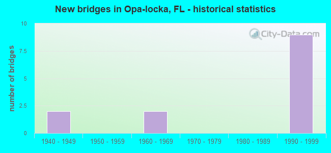
- New bridges - historical statistics
- 21940-1949
- 21960-1969
- 91990-1999

- Reconstructed bridges - Historical Statistics
- 21960-1969
- 11970-1979
- 01980-1989
- 11990-1999


- Bridge Condition - Deck
- 55.6%Very good
- 33.3%Good
- 11.1%Poor

- Bridge Condition - Superstructure
- 55.6%Very good
- 33.3%Good
- 11.1%Poor

- Bridge Condition - Substructure
- 55.6%Very good
- 44.4%Good

- Bridge Condition - Channel
- 75.0%Good
- 25.0%Satisfactory
Find on map >> Show street view
Structure Number: 870089, Location: 0.5M N OF NW 119 ST (Lat: 25.890008, Lng: -80.243308), Route carried "on" structure: State highway 9, Year Built: 1948, Year Reconstructed: 1971, Status: Open, Structure Length: 0.76m (2.49ft), Average Daily Traffic: 43,000 (year 2020), Truck Traffic: 4%, Average Future Daily Traffic: 74,605 (year 2042), Design Load: HS 20, Features Intersected: DRAINAGE CANAL
Minimum Vertical Clearance: 30+ m (98+ ft), Kilometerpoint: 16.629, Lanes on structure: 7, Owner: State Highway Agency, Approaching Roadway Width: 27.1m (88.9ft), Skew: 10 degrees, Material/Design: Concrete, Design/Construction: Culvert, Number Of Spans In Main Unit: 3, Length of Maximum Span: 2.7m (8.9ft), Curb or Sidewalk Widths: Left: 1.4m (4.6ft), Right: 1.5m (4.9ft), Curb-To-Curb Width: 26.8m (87.9ft), Out-to-Out Width: 30.3m (99.4ft)
Condition: Channel: Good, Culverts: Good, Operating Rating: 46.9 metric tons, Method Used To Determine Operating Rating: Load Factor (LF), Inventory Rating: 28.1 metric tons, Method Used To Determine Inventory Rating: Load Factor (LF), Structural Evaluation: Better than present minimum criteria, Deck Geometry: Somewhat better than minimum adequacy, Waterway Adequacy: Better than present minimum criteria, Approach Roadway Alignment: Equal to present desirable criteria, Designated Inspection Frequency: Every 24 months, Underwater Inspection Frequency: Every 24 months, Inspection Date: June 2020, Underwater Inspection Date: June 2020, Deck Structure Type: Other, Wearing Surface/Protective System: Wearing Surface: Bituminous
Find on map >> Show street view
Structure Number: 87009, Location: S OF OPA LOCKA BLVD (Lat: 25.897858, Lng: -80.243611), Route carried "on" structure: State highway 9, Year Built: 1948, Year Reconstructed: 1971, Status: Open, Structure Length: 2.29m (7.51ft), Average Daily Traffic: 48,500 (year 2020), Truck Traffic: 7%, Average Future Daily Traffic: 84,148 (year 2042), Design Load: HS 20, Features Intersected: OPALOCKA CANAL
Minimum Vertical Clearance: 30+ m (98+ ft), Kilometerpoint: 17.498, Lanes on structure: 8, Owner: State Highway Agency, Approaching Roadway Width: 27.4m (89.9ft), Material/Design: Concrete, Design/Construction: Slab, Number Of Spans In Main Unit: 5, Length of Maximum Span: 4.6m (15.1ft), Curb or Sidewalk Widths: Left: 1.4m (4.6ft), Right: 1.4m (4.6ft), Curb-To-Curb Width: 27.0m (88.6ft), Out-to-Out Width: 30.5m (100.1ft)
Condition: Deck: Good, Superstructure: Good, Substructure: Good, Channel: Good, Operating Rating: 38.3 metric tons, Method Used To Determine Operating Rating: Load Factor (LF), Inventory Rating: 23.1 metric tons, Method Used To Determine Inventory Rating: Load Factor (LF), Structural Evaluation: Somewhat better than minimum adequacy, Deck Geometry: High priority of replacement, Waterway Adequacy: Better than present minimum criteria, Approach Roadway Alignment: Equal to present desirable criteria, Designated Inspection Frequency: Every 24 months, Underwater Inspection Frequency: Every 24 months, Inspection Date: June 2020, Underwater Inspection Date: June 2020, Deck Structure Type: Concrete Cast-file-Place, Wearing Surface/Protective System: Wearing Surface: Bituminous
Find on map >> Show street view
Structure Number: 870721, Location: SR 924 over SR 823 (Lat: 25.896306, Lng: -80.291861), Route carried "on" structure: State highway 924, Year Built: 1990, Status: Open, Structure Length: 3.66m (12.01ft), Average Daily Traffic: 70,000 (year 2020), Truck Traffic: 15%, Average Future Daily Traffic: 121,450 (year 2042), Design Load: HS 20, Features Intersected: SR 823 NW 57th Avenue
Minimum Vertical Clearance: 30+ m (98+ ft), Kilometerpoint: 3.261, Lanes on structure: 7, Lanes under structure: 7, Base Highway Network: Yes, Toll: On toll road, Owner: State Toll Authority, Approaching Roadway Width: 40.2m (131.9ft), Skew: 30 degrees, Material/Design: Prestressed concrete, Design/Construction: Stringer/Multi-beam, Number Of Spans In Main Unit: 1, Length of Maximum Span: 36.6m (120.1ft), Curb-To-Curb Width: 38.1m (125.0ft), Out-to-Out Width: 39.4m (129.3ft)
Condition: Deck: Good, Superstructure: Good, Substructure: Good, Operating Rating: 30.3 metric tons, Method Used To Determine Operating Rating: Load and Resistance Factor (LRFR), Inventory Rating: 23.3 metric tons, Method Used To Determine Inventory Rating: Load and Resistance Factor (LRFR), Structural Evaluation: Somewhat better than minimum adequacy, Deck Geometry: Superior to present desirable criteria, Underclear: Somewhat better than minimum adequacy, Approach Roadway Alignment: Equal to present desirable criteria, Designated Inspection Frequency: Every 24 months, Inspection Date: November 2020, Deck Structure Type: Concrete Cast-file-Place
Find on map >> Show street view
Structure Number: 870738, Location: South Exit Ramp to SR 953 (Lat: 25.885139, Lng: -80.267306), Route carried "on" structure: State highway 924, Year Built: 1990, Status: Open, Structure Length: 4.27m (14.01ft), Average Daily Traffic: 45,000 (year 2020), Truck Traffic: 17%, Average Future Daily Traffic: 78,075 (year 2042), Design Load: HS 20, Features Intersected: SR 953 NW 42nd Ave
Minimum Vertical Clearance: 30+ m (98+ ft), Kilometerpoint: 6.140, Lanes on structure: 8, Lanes under structure: 7, Base Highway Network: Yes, Toll: On toll road, Owner: State Toll Authority, Approaching Roadway Width: 41.6m (136.5ft), Skew: 32 degrees, Material/Design: Prestressed concrete, Design/Construction: Stringer/Multi-beam, Number Of Spans In Main Unit: 1, Length of Maximum Span: 42.7m (140.1ft), Curb-To-Curb Width: 41.6m (136.5ft), Out-to-Out Width: 43.3m (142.1ft)
Condition: Deck: Very good, Superstructure: Very good, Substructure: Very good, Operating Rating: 70.8 metric tons, Method Used To Determine Operating Rating: Load Factor (LF), Inventory Rating: 33.7 metric tons, Method Used To Determine Inventory Rating: Load Factor (LF), Structural Evaluation: Equal to present desirable criteria, Deck Geometry: Superior to present desirable criteria, Underclear: Equal to present minimum criteria, Approach Roadway Alignment: Equal to present desirable criteria, Designated Inspection Frequency: Every 24 months, Inspection Date: October 2020, Deck Structure Type: Concrete Cast-file-Place
Find on map >> Show street view
Structure Number: 870739, Location: SR-924 Over N. 37th Ave (Lat: 25.883917, Lng: -80.263333), Route carried "on" structure: State highway 924, Year Built: 1990, Status: Open, Structure Length: 3.78m (12.40ft), Average Daily Traffic: 45,000 (year 2020), Truck Traffic: 17%, Average Future Daily Traffic: 78,075 (year 2042), Design Load: HS 20, Features Intersected: NW 37th Avenue
Minimum Vertical Clearance: 30+ m (98+ ft), Kilometerpoint: 6.574, Lanes on structure: 6, Lanes under structure: 6, Base Highway Network: Yes, Toll: On toll road, Owner: State Toll Authority, Approaching Roadway Width: 37.6m (123.4ft), Skew: 30 degrees, Material/Design: Prestressed concrete, Design/Construction: Stringer/Multi-beam, Number Of Spans In Main Unit: 1, Length of Maximum Span: 37.8m (124.0ft), Curb-To-Curb Width: 37.6m (123.4ft), Out-to-Out Width: 39.3m (128.9ft)
Condition: Deck: Very good, Superstructure: Very good, Substructure: Very good, Operating Rating: 37.7 metric tons, Method Used To Determine Operating Rating: Load and Resistance Factor (LRFR), Inventory Rating: 29.1 metric tons, Method Used To Determine Inventory Rating: Load and Resistance Factor (LRFR), Structural Evaluation: Better than present minimum criteria, Deck Geometry: Superior to present desirable criteria, Underclear: Superior to present desirable criteria, Approach Roadway Alignment: Equal to present desirable criteria, Designated Inspection Frequency: Every 24 months, Inspection Date: October 2020, Deck Structure Type: Concrete Cast-file-Place
Find on map >> Show street view
Structure Number: 87074, Location: WB SR 953 Exit (Lat: 25.882972, Lng: -80.260000), Route carried "on" structure: State highway 924, Year Built: 1991, Status: Open, Structure Length: 16.90m (55.45ft), Average Daily Traffic: 32,500 (year 2020), Truck Traffic: 12%, Average Future Daily Traffic: 56,388 (year 2042), Design Load: HS 20+Mod, Features Intersected: SCR R/R
Minimum Vertical Clearance: 30+ m (98+ ft), Kilometerpoint: 6.853, Lanes on structure: 6, Base Highway Network: Yes, Toll: On toll road, Owner: State Toll Authority, Approaching Roadway Width: 35.4m (116.1ft), Skew: 31 degrees, Material/Design: Prestressed concrete, Design/Construction: Stringer/Multi-beam, Number Of Spans In Main Unit: 7, Length of Maximum Span: 24.2m (79.4ft), Curb-To-Curb Width: 35.4m (116.1ft), Out-to-Out Width: 39.6m (129.9ft)
Condition: Deck: Very good, Superstructure: Very good, Substructure: Very good, Operating Rating: 44.2 metric tons, Method Used To Determine Operating Rating: Load and Resistance Factor (LRFR), Inventory Rating: 22.2 metric tons, Method Used To Determine Inventory Rating: Load and Resistance Factor (LRFR), Structural Evaluation: Somewhat better than minimum adequacy, Deck Geometry: Superior to present desirable criteria, Underclear: Superior to present desirable criteria, Approach Roadway Alignment: Better than present minimum criteria, Designated Inspection Frequency: Every 24 months, Inspection Date: October 2020, Deck Structure Type: Concrete Cast-file-Place
Find on map >> Show street view
Structure Number: 870741, Location: At SR 953 EB On Ramp (Lat: 25.882722, Lng: -80.260372), Route carried "on" structure: Ramp State highway 924, Year Built: 1991, Status: Open, Structure Length: 9.27m (30.41ft), Average Daily Traffic: 9,200 (year 2020), Truck Traffic: 7%, Average Future Daily Traffic: 15,962 (year 2042), Design Load: HS 20, Features Intersected: SCL RAILROAD
Minimum Vertical Clearance: 30+ m (98+ ft), Kilometerpoint: 0.000, Lanes on structure: 1, Base Highway Network: Yes, Toll: On toll road, Owner: State Toll Authority, Approaching Roadway Width: 8.3m (27.2ft), Skew: 1 degrees, Material/Design: Prestressed concrete, Design/Construction: Stringer/Multi-beam, Number Of Spans In Main Unit: 4, Length of Maximum Span: 23.2m (76.1ft), Curb-To-Curb Width: 8.3m (27.2ft), Out-to-Out Width: 9.2m (30.2ft)
Condition: Deck: Very good, Superstructure: Very good, Substructure: Very good, Operating Rating: 54.5 metric tons, Method Used To Determine Operating Rating: Load and Resistance Factor (LRFR), Inventory Rating: 29.8 metric tons, Method Used To Determine Inventory Rating: Load and Resistance Factor (LRFR), Structural Evaluation: Better than present minimum criteria, Deck Geometry: Superior to present desirable criteria, Underclear: Superior to present desirable criteria, Approach Roadway Alignment: Better than present minimum criteria, Designated Inspection Frequency: Every 24 months, Inspection Date: October 2020, Deck Structure Type: Concrete Cast-file-Place
Find on map >> Show street view
Structure Number: 870742, Location: At SR 953 WB Off Ramp (Lat: 25.883194, Lng: -80.260000), Route carried "on" structure: Ramp State highway 924, Year Built: 1991, Status: Open, Structure Length: 10.24m (33.60ft), Average Daily Traffic: 6,500 (year 2020), Truck Traffic: 8%, Average Future Daily Traffic: 11,278 (year 2042), Design Load: HS 20, Features Intersected: SCL RAILROAD
Minimum Vertical Clearance: 30+ m (98+ ft), Kilometerpoint: 0.000, Lanes on structure: 1, Toll: On toll road, Owner: State Toll Authority, Approaching Roadway Width: 8.2m (26.9ft), Skew: 3 degrees, Material/Design: Prestressed concrete, Design/Construction: Stringer/Multi-beam, Number Of Spans In Main Unit: 4, Length of Maximum Span: 25.6m (84.0ft), Curb-To-Curb Width: 8.2m (26.9ft), Out-to-Out Width: 9.2m (30.2ft)
Condition: Deck: Very good, Superstructure: Very good, Substructure: Very good, Operating Rating: 48.2 metric tons, Method Used To Determine Operating Rating: Load and Resistance Factor (LRFR), Inventory Rating: 21.7 metric tons, Method Used To Determine Inventory Rating: Load and Resistance Factor (LRFR), Structural Evaluation: Somewhat better than minimum adequacy, Deck Geometry: Superior to present desirable criteria, Underclear: Superior to present desirable criteria, Approach Roadway Alignment: Equal to present minimum criteria, Designated Inspection Frequency: Every 24 months, Inspection Date: October 2020, Deck Structure Type: Concrete Cast-file-Place
Find on map >> Show street view
Structure Number: 87436, Location: 0.3 Mile S of SR-826 (Lat: 25.921503, Lng: -80.309281), Route carried "on" structure: County highway , Year Built: 1960, Year Reconstructed: 1977, Status: Open, Structure Length: 2.75m (9.02ft), Average Daily Traffic: 28,291 (year 2020), Truck Traffic: 2%, Average Future Daily Traffic: 48,122 (year 2042), Design Load: HS 20, Features Intersected: Biscayne Canal (C-8), Facility Carried by Structure: NW 67th Avenue
Minimum Vertical Clearance: 30+ m (98+ ft), Kilometerpoint: 1.984, Lanes on structure: 5, Owner: County Highway Agency, Approaching Roadway Width: 20.5m (67.3ft), Skew: 20 degrees, Material/Design: Prestressed concrete, Design/Construction: Slab, Number Of Spans In Main Unit: 3, Length of Maximum Span: 9.2m (30.2ft), Curb or Sidewalk Widths: Left: 1.5m (4.9ft), Right: 2.8m (9.2ft), Curb-To-Curb Width: 20.5m (67.3ft), Out-to-Out Width: 31.1m (102.0ft)
Condition: Deck: Poor, Superstructure: Poor, Substructure: Good, Channel: Satisfactory, Operating Rating: 65.8 metric tons, Method Used To Determine Operating Rating: Load Factor (LF), Inventory Rating: 39.4 metric tons, Method Used To Determine Inventory Rating: Load Factor (LF), Structural Evaluation: Meets minimum limits, Deck Geometry: Somewhat better than minimum adequacy, Waterway Adequacy: Better than present minimum criteria, Approach Roadway Alignment: Equal to present desirable criteria, Designated Inspection Frequency: Every 24 months, Underwater Inspection Frequency: Every 24 months, Other Special Inspection Frequency: Every 12 months, Inspection Date: June 2020, Underwater Inspection Date: June 2020, Other Special Inspection Date: June 2021, Deck Structure Type: Concrete Precast Panels, Wearing Surface/Protective System: Wearing Surface: Bituminous
Find on map >> Show street view
Structure Number: 874386, Location: 0.4 Mi N of NW 135th St. (Lat: 25.903250, Lng: -80.235792), Route carried "on" structure: County highway , Year Built: 1964, Year Reconstructed: 1998, Status: Open, Structure Length: 1.23m (4.04ft), Average Daily Traffic: 19,900 (year 2020), Truck Traffic: 5%, Average Future Daily Traffic: 23,000 (year 2042), Design Load: HS 20, Features Intersected: Opa Locka Canal, Facility Carried by Structure: NW 22nd Avenue
Minimum Vertical Clearance: 30+ m (98+ ft), Kilometerpoint: 2.288, Lanes on structure: 6, Owner: County Highway Agency, Approaching Roadway Width: 23.6m (77.4ft), Skew: 22 degrees, Material/Design: Concrete, Design/Construction: Slab, Number Of Spans In Main Unit: 2, Length of Maximum Span: 6.2m (20.3ft), Curb or Sidewalk Widths: Left: 1.8m (5.9ft), Right: 1.8m (5.9ft), Curb-To-Curb Width: 24.9m (81.7ft), Out-to-Out Width: 35.6m (116.8ft)
Condition: Deck: Good, Superstructure: Good, Substructure: Good, Channel: Good, Operating Rating: 50.4 metric tons, Method Used To Determine Operating Rating: Load Factor (LF), Inventory Rating: 30.2 metric tons, Method Used To Determine Inventory Rating: Load Factor (LF), Structural Evaluation: Better than present minimum criteria, Deck Geometry: Somewhat better than minimum adequacy, Waterway Adequacy: Better than present minimum criteria, Approach Roadway Alignment: Equal to present desirable criteria, Designated Inspection Frequency: Every 24 months, Underwater Inspection Frequency: Every 24 months, Inspection Date: July 2021, Underwater Inspection Date: July 2021, Deck Structure Type: Concrete Cast-file-Place, Wearing Surface/Protective System: Wearing Surface: Bituminous
Find on map >> Show street view
Structure Number: 870721, Location: SR 924 over SR 823 (Lat: 25.896306, Lng: -80.291861), Route carried "under" structure: State highway 823, Year Built: 1990, Structure Length: 0. m, Average Daily Traffic: 42,000 (year 2020), Truck Traffic: 6%, Features Intersected: SR 823 NW 57th Avenue, Facility Carried by Structure: SR924 GRATIGNY PKW
Minimum Vertical Clearance: 5.12m (16.80ft), Kilometerpoint: 7.368, Lanes on structure: 7, Lanes under structure: 7, Material/Design: Prestressed concrete, Design/Construction: Stringer/Multi-beam, Length of Maximum Span: 36.6m (120.1ft)
Find on map >> Show street view
Structure Number: 870738, Location: South Exit Ramp to SR 953 (Lat: 25.885139, Lng: -80.267306), Route carried "under" structure: State highway 953, Year Built: 1990, Structure Length: 0. m, Average Daily Traffic: 19,600 (year 2020), Truck Traffic: 8%, Features Intersected: SR 953 NW 42nd Ave, Facility Carried by Structure: SR 924
Minimum Vertical Clearance: 4.79m (15.72ft), Kilometerpoint: 17.597, Lanes on structure: 8, Lanes under structure: 7, Material/Design: Prestressed concrete, Design/Construction: Stringer/Multi-beam, Length of Maximum Span: 42.7m (140.1ft)
Find on map >> Show street view
Structure Number: 870739, Location: SR-924 Over N. 37th Ave (Lat: 25.883917, Lng: -80.263333), Route carried "under" structure: City street 37, Year Built: 1990, Structure Length: 0. m, Average Daily Traffic: 45,000 (year 2020), Truck Traffic: 17%, Features Intersected: NW 37th Avenue, Facility Carried by Structure: SR 924
Minimum Vertical Clearance: 7.47m (24.51ft), Kilometerpoint: 6.550, Lanes on structure: 6, Lanes under structure: 6, Material/Design: Prestressed concrete, Design/Construction: Stringer/Multi-beam, Length of Maximum Span: 37.8m (124.0ft)