Bridge Statistics for Okemos, Michigan (MI)
Condition, Traffic, Stress, Structural Evaluation, Project Costs
- National Bridge Inventory (NBI) Statistics
- 21Number of bridges
- 220ft / 67.2mTotal length
- $2,108,000Total costs
- 381,541Total average daily traffic
- 26,459Total average daily truck traffic
- National Bridge Inventory (NBI) Registered Bridges for Okemos
- No street view available for this location
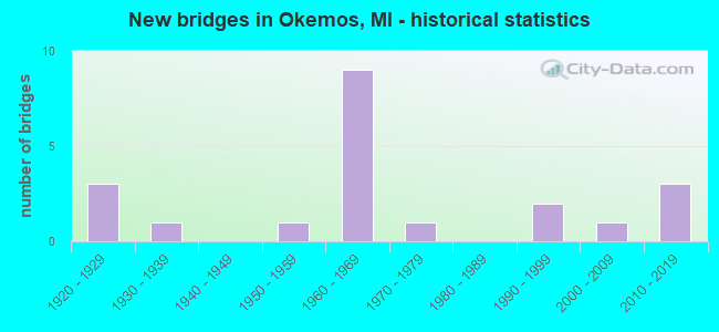
- New bridges - historical statistics
- 31920-1929
- 11930-1939
- 11950-1959
- 91960-1969
- 11970-1979
- 21990-1999
- 12000-2009
- 32010-2019

- Reconstructed bridges - Historical Statistics
- 11920-1929
- 01930-1939
- 01940-1949
- 01950-1959
- 01960-1969
- 11970-1979
- 11980-1989


- Bridge Condition - Deck
- 6.7%Excellent
- 40.0%Good
- 26.7%Satisfactory
- 6.7%Fair
- 6.7%Poor
- 13.3%Serious

- Bridge Condition - Superstructure
- 6.7%Excellent
- 13.3%Very good
- 40.0%Satisfactory
- 20.0%Fair
- 13.3%Poor
- 6.7%Critical

- Bridge Condition - Substructure
- 6.7%Excellent
- 13.3%Very good
- 26.7%Good
- 26.7%Satisfactory
- 13.3%Fair
- 13.3%Poor

- Bridge Condition - Channel
- 8.3%Excellent
- 16.7%Good
- 50.0%Satisfactory
- 25.0%Fair
Find on map >> Show street view
Structure Number: 3796, Location: 0.2 MI E OF PARK LAKE RD (Lat: 42.724653, Lng: -84.442931), Route carried "on" structure: State highway 43, Year Built: 1931, Year Reconstructed: 1970, Status: Open, Structure Length: 0.70m (2.30ft), Average Daily Traffic: 27,408 (year 2007), Truck Traffic: 3%, Average Future Daily Traffic: 31,097 (year 2018), Design Load: HS 20+Mod, Features Intersected: LAKE LANSING OUTLET
Minimum Vertical Clearance: 30.48m (100.00ft), Kilometerpoint: 10.112, Lanes on structure: 4, Owner: State Highway Agency, Approaching Roadway Width: 18.9m (62.0ft), Material/Design: Prestressed concrete, Design/Construction: Box Beam or Girders - Multiple, Number Of Spans In Main Unit: 1, Length of Maximum Span: 7.0m (23.0ft), Curb-To-Curb Width: 21.9m (71.9ft), Out-to-Out Width: 27.4m (89.9ft)
Condition: Deck: Good, Superstructure: Fair, Substructure: Fair, Channel: Fair, Operating Rating: 54.5 metric tons, Method Used To Determine Operating Rating: Field evaluation and documented engineering judgment, Inventory Rating: 32.7 metric tons, Method Used To Determine Inventory Rating: Field evaluation and documented engineering judgment, Structural Evaluation: Somewhat better than minimum adequacy, Deck Geometry: Superior to present desirable criteria, Waterway Adequacy: Better than present minimum criteria, Approach Roadway Alignment: Equal to present desirable criteria, Designated Inspection Frequency: Every 24 months, Inspection Date: August 2020, Deck Structure Type: Concrete Cast-file-Place, Wearing Surface/Protective System: Wearing Surface: Bituminous
Find on map >> Show street view
Structure Number: 3797, Location: 4.4 MI W OF WILLIAMSTON (Lat: 42.709608, Lng: -84.363883), Route carried "on" structure: State highway 43, Year Built: 1924, Year Reconstructed: 1932, Status: Open, Structure Length: 2.71m (8.89ft), Average Daily Traffic: 13,900 (year 2015), Truck Traffic: 3%, Average Future Daily Traffic: 16,354 (year 2018), Design Load: H 15, Features Intersected: RED CEDAR RIVER
Minimum Vertical Clearance: 30.48m (100.00ft), Kilometerpoint: 16.788, Lanes on structure: 3, Owner: State Highway Agency, Approaching Roadway Width: 13.7m (44.9ft), Skew: 3 degrees, Material/Design: Steel, Design/Construction: Girder and Floorbeam System, Number Of Spans In Main Unit: 2, Length of Maximum Span: 13.7m (44.9ft), Curb-To-Curb Width: 14.0m (45.9ft), Out-to-Out Width: 15.0m (49.2ft)
Condition: Deck: Serious, Superstructure: Fair, Substructure: Fair, Channel: Satisfactory, Operating Rating: 25.9 metric tons, Method Used To Determine Operating Rating: Load Factor (LF) rating reported by rating factor (RF) method using MS18 loading, Inventory Rating: 15.6 metric tons, Method Used To Determine Inventory Rating: Load Factor (LF) rating reported by rating factor (RF) method using MS18 loading, Structural Evaluation: High priority of corrective action, Deck Geometry: Somewhat better than minimum adequacy, Waterway Adequacy: Equal to present desirable criteria, Approach Roadway Alignment: Equal to present minimum criteria, Designated Inspection Frequency: Every 12 months, Critical Feature Inspection Frequency: Every 15 months, Inspection Date: August 2021, Critical Feature Inspection Date: August 2021, Bridge Improvement Cost: $16,000, Roadway Improvement Cost: $3,000, Total Project Cost: $32,000, Deck Structure Type: Concrete Cast-file-Place, Wearing Surface/Protective System: Wearing Surface: Latex Concrete
Find on map >> Show street view
Structure Number: 38, Location: 0.1 MI E OF PARK LAKE RD (Lat: 42.724997, Lng: -84.445342), Route carried "on" structure: State highway 43, Year Built: 2009, Status: Open, Structure Length: 6.17m (20.24ft), Average Daily Traffic: 29,000 (year 2010), Truck Traffic: 4%, Average Future Daily Traffic: 37,200 (year 2030), Design Load: Greater than HL93, Features Intersected: GTW RR
Minimum Vertical Clearance: 30.48m (100.00ft), Kilometerpoint: 0.177, Lanes on structure: 2, Base Highway Network: Yes (Inventory Route: 333, Subroute: 93), Owner: State Highway Agency, Approaching Roadway Width: 9.1m (29.9ft), Skew: 3 degrees, Material/Design: Prestressed concrete, Design/Construction: Box Beam or Girders - Multiple, Number Of Spans In Main Unit: 3, Length of Maximum Span: 29.7m (97.4ft), Curb or Sidewalk Widths: Left: 3.6m (11.8ft), Right: 0.0m, Curb-To-Curb Width: 9.1m (29.9ft), Out-to-Out Width: 14.1m (46.3ft)
Condition: Deck: Good, Superstructure: Satisfactory, Substructure: Good, Operating Rating: 52.8 metric tons, Method Used To Determine Operating Rating: Load and Resistance Factor Rating (LRFR) rating reported by rating factor(RF) method using HL-93 loadings, Inventory Rating: 34.3 metric tons, Method Used To Determine Inventory Rating: Load and Resistance Factor Rating (LRFR) rating reported by rating factor(RF) method using HL-93 loadings, Structural Evaluation: Equal to present minimum criteria, Deck Geometry: Meets minimum limits, Underclear: Somewhat better than minimum adequacy, Approach Roadway Alignment: Equal to present desirable criteria, Designated Inspection Frequency: Every 24 months, Inspection Date: August 2020, Deck Structure Type: Concrete Cast-file-Place, Wearing Surface/Protective System: Wearing Surface: Monolithic Concrete, Deck Protection: Epoxy Coated Reinforcing
Find on map >> Show street view
Structure Number: 3801, Location: 0.1 MI E OF PARK LAKE RD (Lat: 42.724994, Lng: -84.445342), Route carried "on" structure: State highway 43, Year Built: 1977, Status: Open, Structure Length: 6.06m (19.88ft), Average Daily Traffic: 27,408 (year 2007), Truck Traffic: 3%, Average Future Daily Traffic: 31,097 (year 2018), Design Load: HS 25 or greater, Features Intersected: GTW RR
Minimum Vertical Clearance: 30.48m (100.00ft), Kilometerpoint: 9.896, Lanes on structure: 2, Base Highway Network: Yes (Inventory Route: 33, Subroute: 1), Owner: State Highway Agency, Approaching Roadway Width: 9.8m (32.2ft), Skew: 4 degrees, Material/Design: Steel, Design/Construction: Stringer/Multi-beam, Number Of Spans In Main Unit: 3, Length of Maximum Span: 26.2m (86.0ft), Curb or Sidewalk Widths: Left: 0.0m, Right: 2.2m (7.2ft), Curb-To-Curb Width: 9.8m (32.2ft), Out-to-Out Width: 12.5m (41.0ft)
Condition: Deck: Satisfactory, Superstructure: Satisfactory, Substructure: Satisfactory, Operating Rating: 72.9 metric tons, Method Used To Determine Operating Rating: Load Factor (LF) rating reported by rating factor (RF) method using MS18 loading, Inventory Rating: 43.7 metric tons, Method Used To Determine Inventory Rating: Load Factor (LF) rating reported by rating factor (RF) method using MS18 loading, Structural Evaluation: Equal to present minimum criteria, Deck Geometry: Meets minimum limits, Underclear: Equal to present desirable criteria, Approach Roadway Alignment: Equal to present desirable criteria, Designated Inspection Frequency: Every 24 months, Inspection Date: August 2020, Deck Structure Type: Concrete Cast-file-Place, Wearing Surface/Protective System: Wearing Surface: Monolithic Concrete
Find on map >> Show street view
Structure Number: 3819, Location: 1.6 MI W OF ZIMMER ROAD (Lat: 42.666767, Lng: -84.342467), Route carried "on" structure: Interstate 96, Year Built: 1962, Status: Open, Structure Length: 0.69m (2.26ft), Average Daily Traffic: 23,287 (year 2007), Truck Traffic: 11%, Average Future Daily Traffic: 31,680 (year 2018), Design Load: HS 20+Mod, Features Intersected: SLOAN CREEK
Minimum Vertical Clearance: 30.48m (100.00ft), Kilometerpoint: 22.049, Lanes on structure: 2, Base Highway Network: Yes (Inventory Route: 33, Subroute: 4), Owner: State Highway Agency, Approaching Roadway Width: 11.0m (36.1ft), Material/Design: Concrete, Design/Construction: Culvert, Number Of Spans In Main Unit: 2, Length of Maximum Span: 3.0m (9.8ft), Curb-To-Curb Width: 10.9m (35.8ft), Out-to-Out Width: 11.0m (36.1ft)
Condition: Channel: Satisfactory, Culverts: Satisfactory, Operating Rating: 97.2 metric tons, Method Used To Determine Operating Rating: Load Factor (LF) rating reported by rating factor (RF) method using MS18 loading, Inventory Rating: 68.7 metric tons, Method Used To Determine Inventory Rating: Load Factor (LF) rating reported by rating factor (RF) method using MS18 loading, Structural Evaluation: Equal to present minimum criteria, Deck Geometry: Meets minimum limits, Waterway Adequacy: Equal to present minimum criteria, Approach Roadway Alignment: Equal to present desirable criteria, Designated Inspection Frequency: Every 24 months, Inspection Date: September 2020
Find on map >> Show street view
Structure Number: 382, Location: 1.6 MI W OF ZIMMER ROAD (Lat: 42.667303, Lng: -84.342353), Route carried "on" structure: Interstate 96, Year Built: 1962, Status: Open, Structure Length: 0.64m (2.10ft), Average Daily Traffic: 23,287 (year 2007), Truck Traffic: 11%, Average Future Daily Traffic: 31,680 (year 2018), Design Load: HS 20+Mod, Features Intersected: SLOAN CREEK
Minimum Vertical Clearance: 30.48m (100.00ft), Kilometerpoint: 22.079, Lanes on structure: 2, Base Highway Network: Yes (Inventory Route: 33, Subroute: 10), Owner: State Highway Agency, Approaching Roadway Width: 11.0m (36.1ft), Material/Design: Concrete, Design/Construction: Culvert, Number Of Spans In Main Unit: 2, Length of Maximum Span: 3.0m (9.8ft), Curb-To-Curb Width: 10.9m (35.8ft), Out-to-Out Width: 11.0m (36.1ft)
Condition: Channel: Satisfactory, Culverts: Satisfactory, Operating Rating: 97.2 metric tons, Method Used To Determine Operating Rating: Load Factor (LF) rating reported by rating factor (RF) method using MS18 loading, Inventory Rating: 78.1 metric tons, Method Used To Determine Inventory Rating: Load Factor (LF) rating reported by rating factor (RF) method using MS18 loading, Structural Evaluation: Equal to present minimum criteria, Deck Geometry: Meets minimum limits, Waterway Adequacy: Equal to present minimum criteria, Approach Roadway Alignment: Equal to present desirable criteria, Designated Inspection Frequency: Every 24 months, Inspection Date: September 2020
Find on map >> Show street view
Structure Number: 3827, Location: 6.0 MI SE OF LANSING (Lat: 42.677831, Lng: -84.462403), Route carried "on" structure: County highway 3333, Year Built: 1962, Status: Open, Structure Length: 6.61m (21.69ft), Average Daily Traffic: 3,425 (year 2018), Truck Traffic: 1%, Average Future Daily Traffic: 3,939 (year 2038), Design Load: H 15, Features Intersected: I-96, Facility Carried by Structure: HAGADORN ROAD
Minimum Vertical Clearance: 30.48m (100.00ft), Kilometerpoint: 28.156, Lanes on structure: 2, Lanes under structure: 4, Owner: State Highway Agency, Approaching Roadway Width: 11.5m (37.7ft), Material/Design: Prestressed concrete, Design/Construction: Stringer/Multi-beam, Number Of Spans In Main Unit: 4, Length of Maximum Span: 21.1m (69.2ft), Curb-To-Curb Width: 9.8m (32.2ft), Out-to-Out Width: 10.6m (34.8ft)
Condition: Deck: Satisfactory, Superstructure: Satisfactory, Substructure: Good, Operating Rating: 67.1 metric tons, Method Used To Determine Operating Rating: Load Factor (LF) rating reported by rating factor (RF) method using MS18 loading, Inventory Rating: 40.2 metric tons, Method Used To Determine Inventory Rating: Load Factor (LF) rating reported by rating factor (RF) method using MS18 loading, Structural Evaluation: Equal to present minimum criteria, Deck Geometry: Meets minimum limits, Underclear: Meets minimum limits, Approach Roadway Alignment: Equal to present desirable criteria, Designated Inspection Frequency: Every 24 months, Inspection Date: September 2020, Deck Structure Type: Concrete Cast-file-Place, Wearing Surface/Protective System: Wearing Surface: Epoxy Overlay
Find on map >> Show street view
Structure Number: 3828, Location: 3.3 MI E OF I-496 (Lat: 42.678517, Lng: -84.432775), Route carried "on" structure: County highway 3337, Year Built: 1963, Year Reconstructed: 1991, Status: Open, Structure Length: 7.22m (23.69ft), Average Daily Traffic: 7,300 (year 1996), Truck Traffic: 1%, Average Future Daily Traffic: 27,150 (year 2005), Design Load: H 20, Features Intersected: I-96, Facility Carried by Structure: OKEMOS RD
Minimum Vertical Clearance: 30.48m (100.00ft), Kilometerpoint: 10.921, Lanes on structure: 4, Lanes under structure: 6, Owner: State Highway Agency, Approaching Roadway Width: 16.7m (54.8ft), Material/Design: Steel, Design/Construction: Stringer/Multi-beam, Number Of Spans In Main Unit: 4, Length of Maximum Span: 24.3m (79.7ft), Curb or Sidewalk Widths: Left: 1.5m (4.9ft), Right: 1.5m (4.9ft), Curb-To-Curb Width: 17.0m (55.8ft), Out-to-Out Width: 21.6m (70.9ft)
Condition: Deck: Satisfactory, Superstructure: Fair, Substructure: Satisfactory, Operating Rating: 80.7 metric tons, Method Used To Determine Operating Rating: Load Factor (LF) rating reported by rating factor (RF) method using MS18 loading, Inventory Rating: 48.3 metric tons, Method Used To Determine Inventory Rating: Load Factor (LF) rating reported by rating factor (RF) method using MS18 loading, Structural Evaluation: Somewhat better than minimum adequacy, Deck Geometry: Somewhat better than minimum adequacy, Underclear: Somewhat better than minimum adequacy, Approach Roadway Alignment: Equal to present desirable criteria, Designated Inspection Frequency: Every 24 months, Inspection Date: September 2020, Bridge Improvement Cost: $238,000, Deck Structure Type: Concrete Cast-file-Place, Wearing Surface/Protective System: Wearing Surface: Monolithic Concrete
Find on map >> Show street view
Structure Number: 3829, Location: 6.9 MI E OF I-496 (Lat: 42.670947, Lng: -84.363608), Route carried "on" structure: County highway 3349, Year Built: 1962, Status: Open, Structure Length: 6.74m (22.11ft), Average Daily Traffic: 3,650 (year 2018), Truck Traffic: 1%, Average Future Daily Traffic: 4,198 (year 2038), Design Load: H 15, Features Intersected: I-96, Facility Carried by Structure: MERIDIAN RD
Minimum Vertical Clearance: 30.48m (100.00ft), Kilometerpoint: 29.013, Lanes on structure: 2, Lanes under structure: 4, Owner: State Highway Agency, Approaching Roadway Width: 11.5m (37.7ft), Skew: 1 degrees, Material/Design: Prestressed concrete, Design/Construction: Stringer/Multi-beam, Number Of Spans In Main Unit: 4, Length of Maximum Span: 22.1m (72.5ft), Curb-To-Curb Width: 9.1m (29.9ft), Out-to-Out Width: 10.0m (32.8ft)
Condition: Deck: Satisfactory, Superstructure: Satisfactory, Substructure: Good, Operating Rating: 57.7 metric tons, Method Used To Determine Operating Rating: Load Factor (LF) rating reported by rating factor (RF) method using MS18 loading, Inventory Rating: 31.1 metric tons, Method Used To Determine Inventory Rating: Load Factor (LF) rating reported by rating factor (RF) method using MS18 loading, Structural Evaluation: Equal to present minimum criteria, Deck Geometry: Meets minimum limits, Underclear: Meets minimum limits, Approach Roadway Alignment: Equal to present desirable criteria, Length Of Structure Improvement: 6.74m (22.11ft), Designated Inspection Frequency: Every 23 months, Inspection Date: October 2020, Bridge Improvement Cost: $26,000, Roadway Improvement Cost: $3,000, Total Project Cost: $31,000, Deck Structure Type: Concrete Cast-file-Place, Wearing Surface/Protective System: Wearing Surface: Epoxy Overlay
Find on map >> Show street view
Structure Number: 3879, Location: 0.1 MI N OF S LMTS OF OKE (Lat: 42.713172, Lng: -84.430986), Route carried "on" structure: County highway 2003, Year Built: 1959, Status: Posted for load, Structure Length: 5.48m (17.98ft), Average Daily Traffic: 17,300 (year 2019), Average Future Daily Traffic: 21,110 (year 2039), Design Load: HS 20, Features Intersected: RED CEDAR RIVER, Facility Carried by Structure: OKEMOS ROAD SB
Minimum Vertical Clearance: 30.48m (100.00ft), Kilometerpoint: 0.219, Lanes on structure: 2, Base Highway Network: Yes (Inventory Route: 333, Subroute: 7), Owner: County Highway Agency, Approaching Roadway Width: 9.8m (32.2ft), Skew: 14 degrees, Material/Design: Steel, Design/Construction: Stringer/Multi-beam, Number Of Spans In Main Unit: 3, Length of Maximum Span: 21.3m (69.9ft), Curb or Sidewalk Widths: Left: 1.2m (3.9ft), Right: 0.4m (1.3ft), Curb-To-Curb Width: 7.3m (24.0ft), Out-to-Out Width: 9.7m (31.8ft)
Condition: Deck: Fair, Superstructure: Poor, Substructure: Satisfactory, Channel: Satisfactory, Operating Rating: 33.4 metric tons, Method Used To Determine Operating Rating: Load Factor (LF) rating reported by rating factor (RF) method using MS18 loading, Inventory Rating: 20.1 metric tons, Method Used To Determine Inventory Rating: Load Factor (LF) rating reported by rating factor (RF) method using MS18 loading, Structural Evaluation: Meets minimum limits, Deck Geometry: High priority of replacement, Waterway Adequacy: Equal to present desirable criteria, Approach Roadway Alignment: Equal to present minimum criteria, Bridge Posting: Required (Relationship of Operating Rating to Maximum Legal Load: > 39.9% below), Length Of Structure Improvement: 5.49m (18.01ft), Designated Inspection Frequency: Every 12 months, Inspection Date: July 2021, Bridge Improvement Cost: $340,000, Roadway Improvement Cost: $11,000, Total Project Cost: $351,000, Deck Structure Type: Concrete Cast-file-Place, Wearing Surface/Protective System: Wearing Surface: Monolithic Concrete
Find on map >> Show street view
Structure Number: 388, Location: 0.1 MI N OF S LMTS OF OKE (Lat: 42.712942, Lng: -84.430989), Route carried "on" structure: County highway 2003, Year Built: 1924, Status: Posted for load, Structure Length: 2.74m (8.99ft), Average Daily Traffic: 14,350 (year 2019), Average Future Daily Traffic: 17,510 (year 2039), Design Load: H 20, Features Intersected: RED CEDAR RIVER, Facility Carried by Structure: OKEMOS ROAD NB
Minimum Vertical Clearance: 30.48m (100.00ft), Kilometerpoint: 14.837, Lanes on structure: 2, Base Highway Network: Yes (Inventory Route: 36, Subroute: 2), Owner: County Highway Agency, Approaching Roadway Width: 7.3m (24.0ft), Skew: 4 degrees, Material/Design: Concrete, Design/Construction: Girder and Floorbeam System, Number Of Spans In Main Unit: 1, Length of Maximum Span: 27.4m (89.9ft), Curb or Sidewalk Widths: Left: 0.0m, Right: 1.5m (4.9ft), Curb-To-Curb Width: 6.1m (20.0ft), Out-to-Out Width: 8.5m (27.9ft)
Condition: Deck: Poor, Superstructure: Poor, Substructure: Poor, Channel: Fair, Operating Rating: 53.5 metric tons, Method Used To Determine Operating Rating: Load Factor (LF) rating reported by rating factor (RF) method using MS18 loading, Inventory Rating: 32.1 metric tons, Method Used To Determine Inventory Rating: Load Factor (LF) rating reported by rating factor (RF) method using MS18 loading, Structural Evaluation: Meets minimum limits, Deck Geometry: High priority of replacement, Waterway Adequacy: Equal to present desirable criteria, Approach Roadway Alignment: Somewhat better than minimum adequacy, Bridge Posting: Required (Relationship of Operating Rating to Maximum Legal Load: 10.0 - 19.9% below), Length Of Structure Improvement: 2.74m (8.99ft), Designated Inspection Frequency: Every 12 months, Inspection Date: July 2021, Bridge Improvement Cost: $20,000, Total Project Cost: $20,000, Deck Structure Type: Concrete Cast-file-Place, Wearing Surface/Protective System: Wearing Surface: Latex Concrete
Find on map >> Show street view
Structure Number: 3882, Location: 1.5 MILES SE OF OKEMOS (Lat: 42.700142, Lng: -84.410353), Route carried "on" structure: County highway , Year Built: 2010, Status: Open, Structure Length: 3.66m (12.01ft), Average Daily Traffic: 12,300 (year 2006), Truck Traffic: 1%, Average Future Daily Traffic: 12,500 (year 2026), Design Load: HL 93, Features Intersected: RED CEDAR RIVER, Facility Carried by Structure: DOBIE ROAD
Minimum Vertical Clearance: 30.48m (100.00ft), Kilometerpoint: 2.511, Lanes on structure: 2, Owner: County Highway Agency, Approaching Roadway Width: 9.1m (29.9ft), Skew: 1 degrees, Material/Design: Prestressed concrete, Design/Construction: Box Beam or Girders - Multiple, Number Of Spans In Main Unit: 1, Length of Maximum Span: 36.6m (120.1ft), Curb or Sidewalk Widths: Left: 2.5m (8.2ft), Right: 0.0m, Curb-To-Curb Width: 9.1m (29.9ft), Out-to-Out Width: 12.6m (41.3ft)
Condition: Deck: Good, Superstructure: Very good, Substructure: Very good, Channel: Satisfactory, Operating Rating: 61.4 metric tons, Method Used To Determine Operating Rating: Load and Resistance Factor (LRFR), Inventory Rating: 44.4 metric tons, Method Used To Determine Inventory Rating: Load and Resistance Factor (LRFR), Structural Evaluation: Equal to present desirable criteria, Deck Geometry: High priority of corrective action, Waterway Adequacy: Superior to present desirable criteria, Approach Roadway Alignment: Equal to present desirable criteria, Designated Inspection Frequency: Every 24 months, Inspection Date: November 2020, Deck Structure Type: Concrete Cast-file-Place, Wearing Surface/Protective System: Wearing Surface: Monolithic Concrete, Deck Protection: Epoxy Coated Reinforcing
Find on map >> Show street view
Structure Number: 3908, Location: 0.5 M NE OF OKEMOS (Lat: 42.723050, Lng: -84.437258), Route carried "on" structure: County highway , Year Built: 1990, Status: Open, Structure Length: 3.65m (11.98ft), Average Daily Traffic: 1,727 (year 2007), Average Future Daily Traffic: 2,204 (year 2027), Design Load: HS 20, Features Intersected: RED CEDAR RIVER, Facility Carried by Structure: NAKOMA DRIVE
Minimum Vertical Clearance: 30.48m (100.00ft), Kilometerpoint: 0.076, Lanes on structure: 2, Owner: County Highway Agency, Approaching Roadway Width: 7.3m (24.0ft), Skew: 3 degrees, Material/Design: Steel, Design/Construction: Stringer/Multi-beam, Number Of Spans In Main Unit: 2, Length of Maximum Span: 18.2m (59.7ft), Curb or Sidewalk Widths: Left: 1.5m (4.9ft), Right: 0.0m, Curb-To-Curb Width: 8.2m (26.9ft), Out-to-Out Width: 10.4m (34.1ft)
Condition: Deck: Good, Superstructure: Satisfactory, Substructure: Good, Channel: Satisfactory, Operating Rating: 81.0 metric tons, Method Used To Determine Operating Rating: Load Factor (LF) rating reported by rating factor (RF) method using MS18 loading, Inventory Rating: 48.6 metric tons, Method Used To Determine Inventory Rating: Load Factor (LF) rating reported by rating factor (RF) method using MS18 loading, Structural Evaluation: Equal to present minimum criteria, Waterway Adequacy: Better than present minimum criteria, Approach Roadway Alignment: Equal to present minimum criteria, Designated Inspection Frequency: Every 24 months, Inspection Date: July 2021, Roadway Improvement Cost: $5,000, Total Project Cost: $5,000, Deck Structure Type: Concrete Cast-file-Place, Wearing Surface/Protective System: Wearing Surface: Latex Concrete, Deck Protection: Epoxy Coated Reinforcing
Find on map >> Show street view
Structure Number: 3909, Location: 2.8 MI SE OF OKEMOS (Lat: 42.696881, Lng: -84.378642), Route carried "on" structure: County highway , Year Built: 2014, Status: Open, Structure Length: 3.09m (10.14ft), Average Daily Traffic: 2,810 (year 2012), Truck Traffic: 3%, Average Future Daily Traffic: 3,000 (year 2032), Design Load: Greater than HL93, Features Intersected: RED CEDAR RIVER, Facility Carried by Structure: VANATTA ROAD
Minimum Vertical Clearance: 30.48m (100.00ft), Kilometerpoint: 1.569, Lanes on structure: 2, Owner: County Highway Agency, Approaching Roadway Width: 7.3m (24.0ft), Material/Design: Prestressed concrete, Design/Construction: Box Beam or Girders - Multiple, Number Of Spans In Main Unit: 1, Length of Maximum Span: 30.5m (100.1ft), Curb or Sidewalk Widths: Left: 2.8m (9.2ft), Right: 0.0m, Curb-To-Curb Width: 8.7m (28.5ft), Out-to-Out Width: 12.7m (41.7ft)
Condition: Deck: Good, Superstructure: Very good, Substructure: Very good, Channel: Good, Operating Rating: 75.8 metric tons, Method Used To Determine Operating Rating: Load and Resistance Factor Rating (LRFR) rating reported by rating factor(RF) method using HL-93 loadings, Inventory Rating: 36.3 metric tons, Method Used To Determine Inventory Rating: Load and Resistance Factor Rating (LRFR) rating reported by rating factor(RF) method using HL-93 loadings, Structural Evaluation: Equal to present desirable criteria, Deck Geometry: Meets minimum limits, Waterway Adequacy: Somewhat better than minimum adequacy, Approach Roadway Alignment: Equal to present minimum criteria, Designated Inspection Frequency: Every 24 months, Inspection Date: July 2020, Deck Structure Type: Concrete Cast-file-Place, Wearing Surface/Protective System: Wearing Surface: Monolithic Concrete, Deck Protection: Epoxy Coated Reinforcing
Find on map >> Show street view
Structure Number: 391, Location: 1.3 MI NW OF OKEMOS (Lat: 42.724078, Lng: -84.444072), Route carried "on" structure: County highway , Year Built: 1925, Status: Posted for load, Structure Length: 0.79m (2.59ft), Average Daily Traffic: 10 (year 2019), Average Future Daily Traffic: 20 (year 2039), Design Load: H 15, Features Intersected: PINE LAKE OUTLET DRAIN, Facility Carried by Structure: SMALL ACRES LANE
Minimum Vertical Clearance: 30.48m (100.00ft), Kilometerpoint: 0.328, Lanes on structure: 2, Owner: County Highway Agency, Approaching Roadway Width: 6.7m (22.0ft), Material/Design: Steel, Design/Construction: Stringer/Multi-beam, Number Of Spans In Main Unit: 1, Length of Maximum Span: 7.9m (25.9ft), Curb-To-Curb Width: 5.8m (19.0ft), Out-to-Out Width: 6.5m (21.3ft)
Condition: Deck: Serious, Superstructure: Critical, Substructure: Poor, Channel: Fair, Operating Rating: 13.9 metric tons, Method Used To Determine Operating Rating: Load Factor (LF) rating reported by rating factor (RF) method using MS18 loading, Inventory Rating: 8.1 metric tons, Method Used To Determine Inventory Rating: Load Factor (LF) rating reported by rating factor (RF) method using MS18 loading, Structural Evaluation: High priority of replacement, Deck Geometry: Meets minimum limits, Waterway Adequacy: Equal to present desirable criteria, Approach Roadway Alignment: Equal to present minimum criteria, Bridge Posting: Required (Relationship of Operating Rating to Maximum Legal Load: > 39.9% below), Length Of Structure Improvement: 1.52m (4.99ft), Designated Inspection Frequency: Every 12 months, Inspection Date: July 2021, Bridge Improvement Cost: $459,000, Roadway Improvement Cost: $110,000, Total Project Cost: $569,000, Deck Structure Type: Concrete Cast-file-Place, Wearing Surface/Protective System: Wearing Surface: Monolithic Concrete
Find on map >> Show street view
Structure Number: 6275, Location: 0.3 MI N OF SUGARBUSH RD (Lat: 42.658083, Lng: -82.776842), Route carried "on" structure: County highway 2058, Year Built: 2019, Status: Open, Structure Length: 3.05m (10.01ft), Average Daily Traffic: 14,500 (year 2018), Truck Traffic: 3%, Average Future Daily Traffic: 18,000 (year 2038), Design Load: Greater than HL93, Features Intersected: SALT RIVER, Facility Carried by Structure: JEFFERSON AVE
Minimum Vertical Clearance: 30.48m (100.00ft), Kilometerpoint: 5.445, Lanes on structure: 2, Owner: County Highway Agency, Approaching Roadway Width: 12.2m (40.0ft), Skew: 1 degrees, Material/Design: Prestressed concrete, Design/Construction: Stringer/Multi-beam, Number Of Spans In Main Unit: 2, Length of Maximum Span: 14.1m (46.3ft), Curb or Sidewalk Widths: Left: 4.3m (14.1ft), Right: 0.0m, Curb-To-Curb Width: 12.2m (40.0ft), Out-to-Out Width: 18.0m (59.1ft)
Condition: Deck: Excellent, Superstructure: Excellent, Substructure: Excellent, Channel: Excellent, Operating Rating: 73.9 metric tons, Method Used To Determine Operating Rating: Load and Resistance Factor Rating (LRFR) rating reported by rating factor(RF) method using HL-93 loadings, Inventory Rating: 56.1 metric tons, Method Used To Determine Inventory Rating: Load and Resistance Factor Rating (LRFR) rating reported by rating factor(RF) method using HL-93 loadings, Structural Evaluation: Superior to present desirable criteria, Deck Geometry: Somewhat better than minimum adequacy, Waterway Adequacy: Equal to present desirable criteria, Approach Roadway Alignment: Better than present minimum criteria, Length Of Structure Improvement: 3.66m (12.01ft), Designated Inspection Frequency: Every 24 months, Underwater Inspection Frequency: Every 60 months, Inspection Date: December 2021, Underwater Inspection Date: August 2018, Bridge Improvement Cost: $900,000, Roadway Improvement Cost: $200,000, Total Project Cost: $1,100,000, Deck Structure Type: Concrete Cast-file-Place, Wearing Surface/Protective System: Wearing Surface: Monolithic Concrete, Deck Protection: Epoxy Coated Reinforcing
Find on map >> Show street view
Structure Number: 8681, Location: 6.1 MI N OF M-32 (Lat: 45.113447, Lng: -84.682467), Route carried "on" structure: County highway , Year Built: 1962, Status: Open, Structure Length: 6.46m (21.19ft), Average Daily Traffic: 90 (year 1988), Average Future Daily Traffic: 50 (year 1977), Design Load: H 15, Features Intersected: I-75 NB, Facility Carried by Structure: WINTERS RD
Minimum Vertical Clearance: 30.48m (100.00ft), Kilometerpoint: 2.522, Lanes on structure: 2, Lanes under structure: 2, Owner: State Highway Agency, Approaching Roadway Width: 10.9m (35.8ft), Skew: 3 degrees, Material/Design: Steel, Design/Construction: Stringer/Multi-beam, Number Of Spans In Main Unit: 3, Length of Maximum Span: 25.0m (82.0ft), Curb-To-Curb Width: 7.8m (25.6ft), Out-to-Out Width: 9.4m (30.8ft)
Condition: Deck: Good, Superstructure: Satisfactory, Substructure: Satisfactory, Operating Rating: 62.2 metric tons, Method Used To Determine Operating Rating: Load Factor (LF) rating reported by rating factor (RF) method using MS18 loading, Inventory Rating: 37.3 metric tons, Method Used To Determine Inventory Rating: Load Factor (LF) rating reported by rating factor (RF) method using MS18 loading, Structural Evaluation: Equal to present minimum criteria, Deck Geometry: Equal to present minimum criteria, Underclear: Meets minimum limits, Approach Roadway Alignment: Equal to present desirable criteria, Designated Inspection Frequency: Every 24 months, Inspection Date: September 2020, Bridge Improvement Cost: $100,000, Deck Structure Type: Concrete Cast-file-Place, Wearing Surface/Protective System: Wearing Surface: Monolithic Concrete
Find on map >> Show street view
Structure Number: 13275, Location: MERIDIAN TWP SEC 15 (Lat: 42.733711, Lng: -84.403031), Route carried "on" structure: County highway , Year Built: 1999, Status: Open, Structure Length: 0.78m (2.56ft), Average Daily Traffic: 560 (year 2019), Truck Traffic: 2%, Average Future Daily Traffic: 690 (year 2039), Design Load: HS 20, Features Intersected: MUD LAKE OUTLET DRAIN, Facility Carried by Structure: TIHART ROAD
Minimum Vertical Clearance: 30.48m (100.00ft), Kilometerpoint: 0.600, Lanes on structure: 2, Owner: County Highway Agency, Approaching Roadway Width: 9.8m (32.2ft), Skew: 3 degrees, Material/Design: Concrete, Design/Construction: Culvert, Number Of Spans In Main Unit: 1, Length of Maximum Span: 7.5m (24.6ft), Curb-To-Curb Width: 9.1m (29.9ft), Out-to-Out Width: 29.3m (96.1ft)
Condition: Channel: Good, Culverts: Satisfactory, Operating Rating: 43.6 metric tons, Method Used To Determine Operating Rating: Field evaluation and documented engineering judgment, Inventory Rating: 32.7 metric tons, Method Used To Determine Inventory Rating: Field evaluation and documented engineering judgment, Structural Evaluation: Equal to present minimum criteria, Deck Geometry: Equal to present minimum criteria, Waterway Adequacy: Superior to present desirable criteria, Approach Roadway Alignment: Equal to present desirable criteria, Designated Inspection Frequency: Every 24 months, Inspection Date: June 2021, Wearing Surface/Protective System: Wearing Surface: Bituminous
Find on map >> Show street view
Structure Number: 3827, Location: 6.0 MI SE OF LANSING (Lat: 42.677831, Lng: -84.462403), Route carried "under" structure: Interstate 96, Year Built: 1962, Structure Length: 0. m, Average Daily Traffic: 63,350 (year 2018), Truck Traffic: 10%, Features Intersected: I-96, Facility Carried by Structure: HAGADORN ROAD
Minimum Vertical Clearance: 5.00m (16.40ft), Kilometerpoint: 12.067, Lanes on structure: 2, Lanes under structure: 4, Material/Design: Prestressed concrete, Design/Construction: Stringer/Multi-beam, Length of Maximum Span: 21.1m (69.2ft)
Find on map >> Show street view
Structure Number: 3828, Location: 3.3 MI E OF I-496 (Lat: 42.678517, Lng: -84.432775), Route carried "under" structure: Interstate 96, Year Built: 1963, Structure Length: 0. m, Average Daily Traffic: 52,004 (year 2007), Truck Traffic: 11%, Features Intersected: I-96, Facility Carried by Structure: OKEMOS RD
Minimum Vertical Clearance: 4.93m (16.17ft), Kilometerpoint: 14.493, Lanes on structure: 4, Lanes under structure: 6, Material/Design: Steel, Design/Construction: Stringer/Multi-beam, Length of Maximum Span: 24.3m (79.7ft)
Find on map >> Show street view
Structure Number: 3829, Location: 6.9 MI E OF I-496 (Lat: 42.670947, Lng: -84.363608), Route carried "under" structure: Interstate 96, Year Built: 1962, Structure Length: 0. m, Average Daily Traffic: 43,875 (year 2018), Truck Traffic: 12%, Features Intersected: I-96, Facility Carried by Structure: MERIDIAN RD
Minimum Vertical Clearance: 5.05m (16.57ft), Kilometerpoint: 20.259, Lanes on structure: 2, Lanes under structure: 4, Material/Design: Prestressed concrete, Design/Construction: Stringer/Multi-beam, Length of Maximum Span: 22.1m (72.5ft)