Bridge Statistics for Oakland Park, Florida (FL)
Condition, Traffic, Stress, Structural Evaluation, Project Costs
- National Bridge Inventory (NBI) Statistics
- 36Number of bridges
- 479ft / 146mTotal length
- 2,666,779Total average daily traffic
- 201,880Total average daily truck traffic
- National Bridge Inventory (NBI) Registered Bridges for Oakland Park
- No street view available for this location
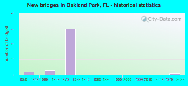
- New bridges - historical statistics
- 21950-1959
- 31960-1969
- 301970-1979
- 12020-2022

- Reconstructed bridges - Historical Statistics
- 81990-1999
- 12000-2009
- 22010-2019
- 22020-2022


- Bridge Condition - Deck
- 4.8%Excellent
- 95.2%Good

- Bridge Condition - Superstructure
- 4.8%Excellent
- 85.7%Good
- 4.8%Satisfactory
- 4.8%Fair

- Bridge Condition - Substructure
- 4.8%Excellent
- 14.3%Very good
- 66.7%Good
- 9.5%Fair
- 4.8%Poor

- Bridge Condition - Channel
- 12.5%Excellent
- 62.5%Good
- 25.0%Satisfactory
Find on map >> Show street view
Structure Number: 860116, Location: 0.2 mi S of Oakland Park (Lat: 26.162456, Lng: -80.162453), Route carried "on" structure: Interstate 95, Year Built: 1972, Year Reconstructed: 1990, Status: Open, Structure Length: 3.29m (10.79ft), Average Daily Traffic: 116,500 (year 2020), Truck Traffic: 8%, Average Future Daily Traffic: 202,128 (year 2042), Design Load: HS 20+Mod, Features Intersected: C-13 Canal
Minimum Vertical Clearance: 30+ m (98+ ft), Kilometerpoint: 21.152, Lanes on structure: 6, Base Highway Network: Yes, Owner: State Highway Agency, Approaching Roadway Width: 23.2m (76.1ft), Material/Design: Prestressed concrete, Design/Construction: Stringer/Multi-beam, Number Of Spans In Main Unit: 3, Length of Maximum Span: 11.1m (36.4ft), Curb-To-Curb Width: 23.6m (77.4ft), Out-to-Out Width: 34.4m (112.9ft)
Condition: Deck: Good, Superstructure: Good, Substructure: Good, Channel: Good, Operating Rating: 47.7 metric tons, Method Used To Determine Operating Rating: Load and Resistance Factor (LRFR), Inventory Rating: 36.9 metric tons, Method Used To Determine Inventory Rating: Load and Resistance Factor (LRFR), Structural Evaluation: Better than present minimum criteria, Deck Geometry: High priority of replacement, Waterway Adequacy: Superior to present desirable criteria, Approach Roadway Alignment: Equal to present desirable criteria, Designated Inspection Frequency: Every 24 months, Underwater Inspection Frequency: Every 8 months, Inspection Date: Febuary 2020, Underwater Inspection Date: June 2021, Deck Structure Type: Concrete Cast-file-Place
Find on map >> Show street view
Structure Number: 860117, Location: .5mi. W of SR-845 (Lat: 26.165972, Lng: -80.160139), Route carried "on" structure: Interstate 95, Year Built: 1971, Year Reconstructed: 2021, Status: Open, Structure Length: 7.74m (25.39ft), Average Daily Traffic: 116,500 (year 2022), Truck Traffic: 8%, Average Future Daily Traffic: 202,128 (year 2042), Design Load: HS 20+Mod, Features Intersected: Oakland Park Blvd.
Minimum Vertical Clearance: 30+ m (98+ ft), Kilometerpoint: 21.581, Lanes on structure: 6, Lanes under structure: 8, Base Highway Network: Yes, Owner: State Highway Agency, Approaching Roadway Width: 30.5m (100.1ft), Skew: 2 degrees, Material/Design: Prestressed concrete, Design/Construction: Stringer/Multi-beam, Number Of Spans In Main Unit: 4, Length of Maximum Span: 25.4m (83.3ft), Curb-To-Curb Width: 30.5m (100.1ft), Out-to-Out Width: 34.4m (112.9ft)
Condition: Deck: Good, Superstructure: Good, Substructure: Good, Operating Rating: 45.7 metric tons, Method Used To Determine Operating Rating: Load and Resistance Factor (LRFR), Inventory Rating: 35.3 metric tons, Method Used To Determine Inventory Rating: Load and Resistance Factor (LRFR), Structural Evaluation: Better than present minimum criteria, Deck Geometry: Superior to present desirable criteria, Underclear: Meets minimum limits, Approach Roadway Alignment: Equal to present desirable criteria, Designated Inspection Frequency: Every 24 months, Inspection Date: January 2022, Deck Structure Type: Concrete Cast-file-Place
Find on map >> Show street view
Structure Number: 860127, Location: .5Mi N of Oakland Pk Blvd (Lat: 26.173861, Lng: -80.156692), Route carried "on" structure: Interstate 95, Year Built: 1974, Year Reconstructed: 2021, Status: Open, Structure Length: 5.70m (18.70ft), Average Daily Traffic: 116,500 (year 2022), Truck Traffic: 8%, Average Future Daily Traffic: 202,128 (year 2042), Design Load: HS 20, Features Intersected: NW 38th Street
Minimum Vertical Clearance: 30+ m (98+ ft), Kilometerpoint: 22.532, Lanes on structure: 5, Lanes under structure: 2, Base Highway Network: Yes, Owner: State Highway Agency, Approaching Roadway Width: 30.5m (100.1ft), Skew: 2 degrees, Material/Design: Prestressed concrete, Design/Construction: Stringer/Multi-beam, Number Of Spans In Main Unit: 3, Length of Maximum Span: 27.7m (90.9ft), Curb-To-Curb Width: 30.5m (100.1ft), Out-to-Out Width: 34.4m (112.9ft)
Condition: Deck: Good, Superstructure: Good, Substructure: Very good, Operating Rating: 46.4 metric tons, Method Used To Determine Operating Rating: Load and Resistance Factor (LRFR), Inventory Rating: 35.9 metric tons, Method Used To Determine Inventory Rating: Load and Resistance Factor (LRFR), Structural Evaluation: Better than present minimum criteria, Deck Geometry: Superior to present desirable criteria, Underclear: Equal to present minimum criteria, Approach Roadway Alignment: Equal to present desirable criteria, Designated Inspection Frequency: Every 24 months, Inspection Date: January 2022, Deck Structure Type: Concrete Cast-file-Place
Find on map >> Show street view
Structure Number: 860128, Location: 0.2Mi. S. of Prospect Rd (Lat: 26.177750, Lng: -80.154806), Route carried "on" structure: Interstate 95, Year Built: 1974, Year Reconstructed: 1990, Status: Open, Structure Length: 15.27m (50.10ft), Average Daily Traffic: 116,500 (year 2020), Truck Traffic: 8%, Average Future Daily Traffic: 202,128 (year 2042), Design Load: HL 93, Features Intersected: NW 9 AVE. (SR-845)
Minimum Vertical Clearance: 30+ m (98+ ft), Kilometerpoint: 23.065, Lanes on structure: 5, Lanes under structure: 6, Base Highway Network: Yes, Owner: State Highway Agency, Approaching Roadway Width: 25.6m (84.0ft), Skew: 6 degrees, Material/Design: Steel continuous, Design/Construction: Stringer/Multi-beam, Number Of Spans In Main Unit: 2, Number Of Approach Spans: 2, Length of Maximum Span: 46.7m (153.2ft), Curb-To-Curb Width: 25.6m (84.0ft), Out-to-Out Width: 26.4m (86.6ft)
Condition: Deck: Good, Superstructure: Good, Substructure: Good, Operating Rating: 45.1 metric tons, Method Used To Determine Operating Rating: Load and Resistance Factor (LRFR), Inventory Rating: 34.9 metric tons, Method Used To Determine Inventory Rating: Load and Resistance Factor (LRFR), Structural Evaluation: Better than present minimum criteria, Deck Geometry: Better than present minimum criteria, Underclear: Equal to present minimum criteria, Approach Roadway Alignment: Equal to present desirable criteria, Designated Inspection Frequency: Every 24 months, Inspection Date: May 2020, Deck Structure Type: Concrete Cast-file-Place
Find on map >> Show street view
Structure Number: 860129, Location: SB I-95 over Prospect RD. (Lat: 26.181056, Lng: -80.153361), Route carried "on" structure: Interstate 95, Year Built: 1974, Year Reconstructed: 2021, Status: Open, Structure Length: 5.52m (18.11ft), Average Daily Traffic: 116,500 (year 2020), Truck Traffic: 8%, Average Future Daily Traffic: 202,128 (year 2042), Design Load: HS 20+Mod, Features Intersected: Prospect RD (NW 44th ST)
Minimum Vertical Clearance: 30+ m (98+ ft), Kilometerpoint: 23.424, Lanes on structure: 5, Lanes under structure: 6, Base Highway Network: Yes, Owner: State Highway Agency, Approaching Roadway Width: 22.3m (73.2ft), Skew: 2 degrees, Material/Design: Prestressed concrete, Design/Construction: Stringer/Multi-beam, Number Of Spans In Main Unit: 3, Length of Maximum Span: 27.7m (90.9ft), Curb-To-Curb Width: 22.3m (73.2ft), Out-to-Out Width: 38.1m (125.0ft)
Condition: Deck: Good, Superstructure: Good, Substructure: Good, Operating Rating: 44.1 metric tons, Method Used To Determine Operating Rating: Load and Resistance Factor (LRFR), Inventory Rating: 33.9 metric tons, Method Used To Determine Inventory Rating: Load and Resistance Factor (LRFR), Structural Evaluation: Better than present minimum criteria, Deck Geometry: Meets minimum limits, Underclear: Equal to present minimum criteria, Approach Roadway Alignment: Equal to present desirable criteria, Designated Inspection Frequency: Every 24 months, Inspection Date: March 2020, Deck Structure Type: Concrete Cast-file-Place
Find on map >> Show street view
Structure Number: 86013, Location: I-95 & Comm Bld Interchge (Lat: 26.188342, Lng: -80.152097), Route carried "on" structure: Interstate 95, Year Built: 1974, Year Reconstructed: 1990, Status: Open, Structure Length: 5.39m (17.68ft), Average Daily Traffic: 116,500 (year 2020), Truck Traffic: 8%, Average Future Daily Traffic: 202,128 (year 2042), Design Load: HS 20, Features Intersected: SR-870 Commercial Blvd.
Minimum Vertical Clearance: 4.75m (15.58ft), Kilometerpoint: 24.258, Lanes on structure: 4, Lanes under structure: 8, Base Highway Network: Yes, Owner: State Highway Agency, Approaching Roadway Width: 20.4m (66.9ft), Material/Design: Prestressed concrete, Design/Construction: Stringer/Multi-beam, Number Of Spans In Main Unit: 2, Length of Maximum Span: 28.1m (92.2ft), Curb-To-Curb Width: 20.6m (67.6ft), Out-to-Out Width: 21.5m (70.5ft)
Condition: Deck: Good, Superstructure: Good, Substructure: Good, Operating Rating: 50.8 metric tons, Method Used To Determine Operating Rating: Load Factor (LF), Inventory Rating: 44.7 metric tons, Method Used To Determine Inventory Rating: Load Factor (LF), Structural Evaluation: Better than present minimum criteria, Deck Geometry: Meets minimum limits, Underclear: Somewhat better than minimum adequacy, Approach Roadway Alignment: Equal to present desirable criteria, Designated Inspection Frequency: Every 24 months, Inspection Date: April 2020, Deck Structure Type: Concrete Cast-file-Place
Find on map >> Show street view
Structure Number: 860131, Location: 1.0 Mile West of SR-811 (Lat: 26.188539, Lng: -80.151628), Route carried "on" structure: Ramp Interstate 95, Year Built: 1974, Status: Open, Structure Length: 23.44m (76.90ft), Average Daily Traffic: 13,500 (year 2020), Truck Traffic: 5%, Average Future Daily Traffic: 23,422 (year 2042), Design Load: HS 20, Features Intersected: I95 and SR870 Commercial
Minimum Vertical Clearance: 30+ m (98+ ft), Kilometerpoint: 0.270, Lanes on structure: 1, Lanes under structure: 14, Owner: State Highway Agency, Approaching Roadway Width: 9.1m (29.9ft), Material/Design: Steel continuous, Design/Construction: Stringer/Multi-beam, Number Of Spans In Main Unit: 2, Number Of Approach Spans: 6, Length of Maximum Span: 40.8m (133.9ft), Curb-To-Curb Width: 8.2m (26.9ft), Out-to-Out Width: 8.9m (29.2ft)
Condition: Deck: Good, Superstructure: Good, Substructure: Very good, Operating Rating: 59.3 metric tons, Method Used To Determine Operating Rating: Load Factor (LF), Inventory Rating: 51.0 metric tons, Method Used To Determine Inventory Rating: Load Factor (LF), Structural Evaluation: Better than present minimum criteria, Deck Geometry: Superior to present desirable criteria, Underclear: Meets minimum limits, Approach Roadway Alignment: Equal to present desirable criteria, Designated Inspection Frequency: Every 24 months, Inspection Date: June 2020, Deck Structure Type: Concrete Cast-file-Place
Find on map >> Show street view
Structure Number: 860139, Location: SR-816 just W. of I-95 (Lat: 26.165947, Lng: -80.161369), Route carried "on" structure: State highway 816, Year Built: 1965, Year Reconstructed: 2004, Status: Open, Structure Length: 3.06m (10.04ft), Average Daily Traffic: 51,500 (year 2020), Truck Traffic: 6%, Average Future Daily Traffic: 89,352 (year 2042), Design Load: HS 20+Mod, Features Intersected: C-13 Canal, Facility Carried by Structure: Oakland Park Blvd.
Minimum Vertical Clearance: 30+ m (98+ ft), Kilometerpoint: 9.526, Lanes on structure: 8, Base Highway Network: Yes, Owner: State Highway Agency, Approaching Roadway Width: 23.2m (76.1ft), Skew: 21 degrees, Material/Design: Prestressed concrete, Design/Construction: Slab, Number Of Spans In Main Unit: 3, Length of Maximum Span: 10.2m (33.5ft), Curb or Sidewalk Widths: Left: 1.8m (5.9ft), Right: 2.0m (6.6ft), Curb-To-Curb Width: 32.7m (107.3ft), Out-to-Out Width: 39.6m (129.9ft)
Condition: Deck: Good, Superstructure: Good, Substructure: Good, Channel: Good, Operating Rating: 55.9 metric tons, Method Used To Determine Operating Rating: Load Factor (LF), Inventory Rating: 33.6 metric tons, Method Used To Determine Inventory Rating: Load Factor (LF), Structural Evaluation: Better than present minimum criteria, Deck Geometry: Somewhat better than minimum adequacy, Waterway Adequacy: Superior to present desirable criteria, Approach Roadway Alignment: Equal to present desirable criteria, Designated Inspection Frequency: Every 24 months, Underwater Inspection Frequency: Every 24 months, Inspection Date: December 2021, Underwater Inspection Date: December 2021, Deck Structure Type: Concrete Precast Panels, Wearing Surface/Protective System: Wearing Surface: Bituminous
Find on map >> Show street view
Structure Number: 860196, Location: I-95 & Comm Bld Interchge (Lat: 26.188347, Lng: -80.151831), Route carried "on" structure: Interstate 95, Year Built: 1974, Year Reconstructed: 2020, Status: Open, Structure Length: 5.39m (17.68ft), Average Daily Traffic: 116,500 (year 2020), Truck Traffic: 8%, Average Future Daily Traffic: 202,128 (year 2042), Design Load: HS 20+Mod, Features Intersected: SR 870 Commercial Blvd.
Minimum Vertical Clearance: 4.75m (15.58ft), Kilometerpoint: 24.258, Lanes on structure: 4, Lanes under structure: 8, Base Highway Network: Yes, Owner: State Highway Agency, Approaching Roadway Width: 20.4m (66.9ft), Material/Design: Prestressed concrete, Design/Construction: Stringer/Multi-beam, Number Of Spans In Main Unit: 2, Length of Maximum Span: 28.1m (92.2ft), Curb-To-Curb Width: 20.6m (67.6ft), Out-to-Out Width: 21.5m (70.5ft)
Condition: Deck: Good, Superstructure: Good, Substructure: Good, Operating Rating: 47.0 metric tons, Method Used To Determine Operating Rating: Load and Resistance Factor (LRFR), Inventory Rating: 34.7 metric tons, Method Used To Determine Inventory Rating: Load and Resistance Factor (LRFR), Structural Evaluation: Better than present minimum criteria, Deck Geometry: Meets minimum limits, Underclear: Meets minimum limits, Approach Roadway Alignment: Equal to present desirable criteria, Designated Inspection Frequency: Every 24 months, Inspection Date: April 2020, Deck Structure Type: Concrete Cast-file-Place
Find on map >> Show street view
Structure Number: 860197, Location: .5mi N of Oakland Pk Blvd (Lat: 26.173406, Lng: -80.156367), Route carried "on" structure: Interstate 95, Year Built: 1974, Year Reconstructed: 1990, Status: Open, Structure Length: 5.70m (18.70ft), Average Daily Traffic: 116,500 (year 2022), Truck Traffic: 8%, Average Future Daily Traffic: 202,128 (year 2042), Design Load: HS 20+Mod, Features Intersected: NW 38th Street
Minimum Vertical Clearance: 30+ m (98+ ft), Kilometerpoint: 22.552, Lanes on structure: 5, Lanes under structure: 2, Base Highway Network: Yes, Owner: State Highway Agency, Approaching Roadway Width: 20.6m (67.6ft), Skew: 2 degrees, Material/Design: Prestressed concrete, Design/Construction: Stringer/Multi-beam, Number Of Spans In Main Unit: 3, Length of Maximum Span: 27.7m (90.9ft), Curb-To-Curb Width: 25.5m (83.7ft), Out-to-Out Width: 38.1m (125.0ft)
Condition: Deck: Good, Superstructure: Good, Substructure: Good, Operating Rating: 45.4 metric tons, Method Used To Determine Operating Rating: Load and Resistance Factor (LRFR), Inventory Rating: 35.3 metric tons, Method Used To Determine Inventory Rating: Load and Resistance Factor (LRFR), Structural Evaluation: Better than present minimum criteria, Deck Geometry: Better than present minimum criteria, Underclear: Equal to present minimum criteria, Approach Roadway Alignment: Equal to present desirable criteria, Designated Inspection Frequency: Every 24 months, Inspection Date: January 2022, Deck Structure Type: Concrete Cast-file-Place
Find on map >> Show street view
Structure Number: 860198, Location: 0.2 Mile S of Prospect Rd (Lat: 26.177194, Lng: -80.154778), Route carried "on" structure: Interstate 95, Year Built: 1974, Year Reconstructed: 1990, Status: Open, Structure Length: 15.27m (50.10ft), Average Daily Traffic: 116,500 (year 2020), Truck Traffic: 8%, Average Future Daily Traffic: 202,128 (year 2042), Design Load: HL 93, Features Intersected: SR-845 (NW-9 AVE)
Minimum Vertical Clearance: 30+ m (98+ ft), Kilometerpoint: 22.904, Lanes on structure: 5, Lanes under structure: 6, Base Highway Network: Yes, Owner: State Highway Agency, Approaching Roadway Width: 25.6m (84.0ft), Skew: 6 degrees, Material/Design: Steel continuous, Design/Construction: Stringer/Multi-beam, Number Of Spans In Main Unit: 2, Number Of Approach Spans: 2, Length of Maximum Span: 46.7m (153.2ft), Curb-To-Curb Width: 25.6m (84.0ft), Out-to-Out Width: 35.0m (114.8ft)
Condition: Deck: Good, Superstructure: Good, Substructure: Good, Operating Rating: 44.1 metric tons, Method Used To Determine Operating Rating: Load and Resistance Factor (LRFR), Inventory Rating: 33.9 metric tons, Method Used To Determine Inventory Rating: Load and Resistance Factor (LRFR), Structural Evaluation: Better than present minimum criteria, Deck Geometry: Better than present minimum criteria, Underclear: Equal to present minimum criteria, Approach Roadway Alignment: Equal to present desirable criteria, Designated Inspection Frequency: Every 24 months, Inspection Date: May 2020, Deck Structure Type: Concrete Cast-file-Place
Find on map >> Show street view
Structure Number: 860199, Location: NB I-95 over Prospect RD. (Lat: 26.181056, Lng: -80.153028), Route carried "on" structure: Interstate 95, Year Built: 1974, Year Reconstructed: 1990, Status: Open, Structure Length: 5.52m (18.11ft), Average Daily Traffic: 116,500 (year 2020), Truck Traffic: 8%, Average Future Daily Traffic: 202,128 (year 2042), Design Load: HS 20+Mod, Features Intersected: Prospect RD (NW 44th ST)
Minimum Vertical Clearance: 30+ m (98+ ft), Kilometerpoint: 23.438, Lanes on structure: 5, Lanes under structure: 6, Base Highway Network: Yes, Owner: State Highway Agency, Approaching Roadway Width: 20.4m (66.9ft), Skew: 2 degrees, Material/Design: Prestressed concrete, Design/Construction: Stringer/Multi-beam, Number Of Spans In Main Unit: 3, Length of Maximum Span: 27.7m (90.9ft), Curb-To-Curb Width: 25.5m (83.7ft), Out-to-Out Width: 35.8m (117.5ft)
Condition: Deck: Good, Superstructure: Good, Substructure: Good, Operating Rating: 44.1 metric tons, Method Used To Determine Operating Rating: Load and Resistance Factor (LRFR), Inventory Rating: 33.9 metric tons, Method Used To Determine Inventory Rating: Load and Resistance Factor (LRFR), Structural Evaluation: Better than present minimum criteria, Deck Geometry: Better than present minimum criteria, Underclear: Equal to present minimum criteria, Approach Roadway Alignment: Equal to present desirable criteria, Designated Inspection Frequency: Every 24 months, Inspection Date: March 2020, Deck Structure Type: Concrete Cast-file-Place
Find on map >> Show street view
Structure Number: 860216, Location: 0.2 mi S of Oakland Park (Lat: 26.162325, Lng: -80.162186), Route carried "on" structure: Interstate 95, Year Built: 1972, Year Reconstructed: 1990, Status: Open, Structure Length: 3.29m (10.79ft), Average Daily Traffic: 116,500 (year 2020), Truck Traffic: 8%, Average Future Daily Traffic: 202,128 (year 2042), Design Load: HS 20+Mod, Features Intersected: C-13 Canal
Minimum Vertical Clearance: 30+ m (98+ ft), Kilometerpoint: 21.152, Lanes on structure: 6, Base Highway Network: Yes, Owner: State Highway Agency, Approaching Roadway Width: 29.4m (96.5ft), Material/Design: Prestressed concrete, Design/Construction: Stringer/Multi-beam, Number Of Spans In Main Unit: 3, Length of Maximum Span: 11.1m (36.4ft), Curb-To-Curb Width: 29.4m (96.5ft), Out-to-Out Width: 33.7m (110.6ft)
Condition: Deck: Good, Superstructure: Good, Substructure: Good, Channel: Good, Operating Rating: 46.1 metric tons, Method Used To Determine Operating Rating: Load and Resistance Factor (LRFR), Inventory Rating: 35.6 metric tons, Method Used To Determine Inventory Rating: Load and Resistance Factor (LRFR), Structural Evaluation: Better than present minimum criteria, Deck Geometry: Better than present minimum criteria, Waterway Adequacy: Superior to present desirable criteria, Approach Roadway Alignment: Equal to present desirable criteria, Designated Inspection Frequency: Every 24 months, Underwater Inspection Frequency: Every 24 months, Inspection Date: Febuary 2020, Underwater Inspection Date: Febuary 2020, Deck Structure Type: Concrete Cast-file-Place
Find on map >> Show street view
Structure Number: 860217, Location: .4mi. W of SR-845 (Lat: 26.166000, Lng: -80.159806), Route carried "on" structure: Interstate 95, Year Built: 1971, Year Reconstructed: 2020, Status: Open, Structure Length: 7.74m (25.39ft), Average Daily Traffic: 116,500 (year 2022), Truck Traffic: 8%, Average Future Daily Traffic: 202,128 (year 2042), Design Load: HS 20+Mod, Features Intersected: Oakland Pk. Blvd.
Minimum Vertical Clearance: 30+ m (98+ ft), Kilometerpoint: 21.630, Lanes on structure: 6, Lanes under structure: 8, Base Highway Network: Yes, Owner: State Highway Agency, Approaching Roadway Width: 24.4m (80.1ft), Skew: 2 degrees, Material/Design: Prestressed concrete, Design/Construction: Stringer/Multi-beam, Number Of Spans In Main Unit: 4, Length of Maximum Span: 25.4m (83.3ft), Curb-To-Curb Width: 28.0m (91.9ft), Out-to-Out Width: 40.1m (131.6ft)
Condition: Deck: Good, Superstructure: Good, Substructure: Good, Operating Rating: 61.1 metric tons, Method Used To Determine Operating Rating: Load and Resistance Factor (LRFR), Inventory Rating: 42.5 metric tons, Method Used To Determine Inventory Rating: Load and Resistance Factor (LRFR), Structural Evaluation: Better than present minimum criteria, Deck Geometry: Equal to present minimum criteria, Underclear: Meets minimum limits, Approach Roadway Alignment: Equal to present desirable criteria, Designated Inspection Frequency: Every 24 months, Inspection Date: January 2022, Deck Structure Type: Concrete Cast-file-Place
Find on map >> Show street view
Structure Number: 860221, Location: At Andrews Avenue (Lat: 26.166522, Lng: -80.146169), Route carried "on" structure: State highway 816, Year Built: 1965, Status: Open, Structure Length: 0.76m (2.49ft), Average Daily Traffic: 25,000 (year 2020), Truck Traffic: 5%, Average Future Daily Traffic: 43,375 (year 2042), Design Load: HS 20, Features Intersected: N. Fork Middle River, Facility Carried by Structure: Oakland Park Blvd
Minimum Vertical Clearance: 30+ m (98+ ft), Kilometerpoint: 11.053, Lanes on structure: 7, Base Highway Network: Yes, Owner: State Highway Agency, Approaching Roadway Width: 21.3m (69.9ft), Skew: 1 degrees, Material/Design: Concrete, Design/Construction: Culvert, Number Of Spans In Main Unit: 2, Length of Maximum Span: 3.8m (12.5ft), Curb or Sidewalk Widths: Left: 1.5m (4.9ft), Right: 1.5m (4.9ft)
Condition: Channel: Satisfactory, Culverts: Satisfactory, Operating Rating: 70.5 metric tons, Method Used To Determine Operating Rating: Load Factor (LF), Inventory Rating: 42.3 metric tons, Method Used To Determine Inventory Rating: Load Factor (LF), Structural Evaluation: Equal to present minimum criteria, Waterway Adequacy: Equal to present desirable criteria, Approach Roadway Alignment: Equal to present desirable criteria, Designated Inspection Frequency: Every 24 months, Underwater Inspection Frequency: Every 24 months, Inspection Date: March 2020, Underwater Inspection Date: March 2020
Find on map >> Show street view
Structure Number: 860237, Location: 0.5 MI N OF SR-870 (Lat: 26.199586, Lng: -80.148211), Route carried "on" structure: County highway , Year Built: 1975, Status: Open, Structure Length: 8.66m (28.41ft), Average Daily Traffic: 30,000 (year 2020), Truck Traffic: 5%, Average Future Daily Traffic: 52,050 (year 2042), Design Load: HS 20+Mod, Features Intersected: I-95 (SR-9), Facility Carried by Structure: ANDREWS AVE.
Minimum Vertical Clearance: 30+ m (98+ ft), Kilometerpoint: 1.226, Lanes on structure: 4, Lanes under structure: 10, Owner: State Highway Agency, Approaching Roadway Width: 21.9m (71.9ft), Skew: 21 degrees, Material/Design: Prestressed concrete, Design/Construction: Stringer/Multi-beam, Number Of Spans In Main Unit: 4, Length of Maximum Span: 31.6m (103.7ft), Curb or Sidewalk Widths: Left: 1.5m (4.9ft), Right: 1.5m (4.9ft), Curb-To-Curb Width: 21.9m (71.9ft), Out-to-Out Width: 30.4m (99.7ft)
Condition: Deck: Good, Superstructure: Fair, Substructure: Very good, Operating Rating: 52.6 metric tons, Method Used To Determine Operating Rating: Load Factor (LF), Inventory Rating: 45.4 metric tons, Method Used To Determine Inventory Rating: Load Factor (LF), Structural Evaluation: Somewhat better than minimum adequacy, Deck Geometry: Superior to present desirable criteria, Underclear: Meets minimum limits, Approach Roadway Alignment: Equal to present desirable criteria, Designated Inspection Frequency: Every 24 months, Inspection Date: August 2020, Deck Structure Type: Concrete Cast-file-Place
Find on map >> Show street view
Structure Number: 860239, Location: I-95 over Cypress Creek R (Lat: 26.203583, Lng: -80.144106), Route carried "on" structure: Interstate 95, Year Built: 1976, Year Reconstructed: 2019, Status: Open, Structure Length: 9.72m (31.89ft), Average Daily Traffic: 116,500 (year 2020), Truck Traffic: 8%, Average Future Daily Traffic: 202,128 (year 2042), Design Load: HS 20+Mod, Features Intersected: Cypress Creek Rd(NW62St)
Minimum Vertical Clearance: 30+ m (98+ ft), Kilometerpoint: 26.147, Lanes on structure: 5, Lanes under structure: 9, Base Highway Network: Yes, Owner: State Highway Agency, Approaching Roadway Width: 29.9m (98.1ft), Skew: 4 degrees, Material/Design: Prestressed concrete, Design/Construction: Stringer/Multi-beam, Number Of Spans In Main Unit: 4, Length of Maximum Span: 30.4m (99.7ft), Curb-To-Curb Width: 29.9m (98.1ft), Out-to-Out Width: 30.9m (101.4ft)
Condition: Deck: Good, Superstructure: Good, Substructure: Good, Operating Rating: 41.8 metric tons, Method Used To Determine Operating Rating: Load and Resistance Factor (LRFR), Inventory Rating: 32.7 metric tons, Method Used To Determine Inventory Rating: Load and Resistance Factor (LRFR), Structural Evaluation: Better than present minimum criteria, Deck Geometry: Superior to present desirable criteria, Underclear: Meets minimum limits, Approach Roadway Alignment: Equal to present desirable criteria, Designated Inspection Frequency: Every 24 months, Inspection Date: June 2020, Deck Structure Type: Concrete Cast-file-Place
Find on map >> Show street view
Structure Number: 86024, Location: 1.0 Mile North of SR-870 (Lat: 26.203608, Lng: -80.143744), Route carried "on" structure: Interstate 95, Year Built: 1975, Year Reconstructed: 2019, Status: Open, Structure Length: 9.72m (31.89ft), Average Daily Traffic: 116,500 (year 2020), Truck Traffic: 8%, Average Future Daily Traffic: 202,128 (year 2042), Design Load: HS 20+Mod, Features Intersected: Cypress Creek Rd(NW62St)
Minimum Vertical Clearance: 30+ m (98+ ft), Kilometerpoint: 26.194, Lanes on structure: 5, Lanes under structure: 9, Base Highway Network: Yes, Owner: State Highway Agency, Approaching Roadway Width: 25.9m (85.0ft), Skew: 4 degrees, Material/Design: Prestressed concrete, Design/Construction: Stringer/Multi-beam, Number Of Spans In Main Unit: 4, Length of Maximum Span: 30.4m (99.7ft), Curb-To-Curb Width: 25.9m (85.0ft), Out-to-Out Width: 26.9m (88.3ft)
Condition: Deck: Good, Superstructure: Satisfactory, Substructure: Good, Operating Rating: 43.1 metric tons, Method Used To Determine Operating Rating: Load and Resistance Factor (LRFR), Inventory Rating: 33.9 metric tons, Method Used To Determine Inventory Rating: Load and Resistance Factor (LRFR), Structural Evaluation: Equal to present minimum criteria, Deck Geometry: Superior to present desirable criteria, Underclear: Meets minimum limits, Approach Roadway Alignment: Equal to present desirable criteria, Designated Inspection Frequency: Every 24 months, Inspection Date: June 2020, Deck Structure Type: Concrete Cast-file-Place
Find on map >> Show street view
Structure Number: 86413, Location: 0.90 miles West of I-95 (Lat: 26.173278, Lng: -80.171000), Route carried "on" structure: County highway , Year Built: 2020, Status: Open, Structure Length: 2.64m (8.66ft), Average Daily Traffic: 15,704 (year 2021), Average Future Daily Traffic: 27,246 (year 2042), Design Load: HL 93, Features Intersected: Canal C-13, Facility Carried by Structure: NW 21st Avenue
Minimum Vertical Clearance: 30+ m (98+ ft), Kilometerpoint: 0.838, Lanes on structure: 2, Owner: County Highway Agency, Approaching Roadway Width: 10.7m (35.1ft), Skew: 2 degrees, Material/Design: Prestressed concrete, Design/Construction: Stringer/Multi-beam, Number Of Spans In Main Unit: 1, Length of Maximum Span: 26.4m (86.6ft), Curb or Sidewalk Widths: Left: 0.0m, Right: 2.0m (6.6ft), Curb-To-Curb Width: 12.0m (39.4ft), Out-to-Out Width: 14.9m (48.9ft)
Condition: Deck: Excellent, Superstructure: Excellent, Substructure: Excellent, Channel: Excellent, Operating Rating: 49.6 metric tons, Method Used To Determine Operating Rating: Load and Resistance Factor (LRFR), Inventory Rating: 38.2 metric tons, Method Used To Determine Inventory Rating: Load and Resistance Factor (LRFR), Structural Evaluation: Superior to present desirable criteria, Deck Geometry: Somewhat better than minimum adequacy, Waterway Adequacy: Equal to present desirable criteria, Approach Roadway Alignment: Equal to present desirable criteria, Designated Inspection Frequency: Every 24 months, Inspection Date: January 2021, Deck Structure Type: Concrete Cast-file-Place, Wearing Surface/Protective System: Wearing Surface: Monolithic Concrete
Find on map >> Show street view
Structure Number: 867602, Location: 0.2MI N OF NE 38TH ST. (Lat: 26.178089, Lng: -80.126011), Route carried "on" structure: City street , Year Built: 1958, Status: Posted for load, Structure Length: 0.67m (2.20ft), Average Daily Traffic: 3,000 (year 2021), Truck Traffic: 3%, Average Future Daily Traffic: 6,940 (year 2042), Features Intersected: CORAL WATERWAY, Facility Carried by Structure: NE 16TH AVENUE
Minimum Vertical Clearance: 30+ m (98+ ft), Kilometerpoint: 2.050, Lanes on structure: 2, Owner: City or Municipal Highway Agency, Approaching Roadway Width: 6.6m (21.7ft), Material/Design: Prestressed concrete, Design/Construction: Channel Beam, Number Of Spans In Main Unit: 1, Length of Maximum Span: 6.7m (22.0ft), Curb or Sidewalk Widths: Left: 0.9m (3.0ft), Right: 0.3m (1.0ft), Curb-To-Curb Width: 7.3m (24.0ft), Out-to-Out Width: 9.1m (29.9ft)
Condition: Deck: Good, Superstructure: Good, Substructure: Poor, Channel: Good, Operating Rating: 19.6 metric tons, Method Used To Determine Operating Rating: Load and Resistance Factor (LRFR), Inventory Rating: 12.7 metric tons, Method Used To Determine Inventory Rating: Load and Resistance Factor (LRFR), Structural Evaluation: Meets minimum limits, Deck Geometry: High priority of replacement, Waterway Adequacy: Better than present minimum criteria, Approach Roadway Alignment: Better than present minimum criteria, Bridge Posting: Required (Relationship of Operating Rating to Maximum Legal Load: 30.0 - 39.9% below), Designated Inspection Frequency: Every 24 months, Underwater Inspection Frequency: Every 24 months, Other Special Inspection Frequency: Every 12 months, Inspection Date: March 2021, Underwater Inspection Date: March 2021, Other Special Inspection Date: March 2021, Deck Structure Type: Concrete Cast-file-Place, Wearing Surface/Protective System: Wearing Surface: Bituminous
Find on map >> Show street view
Structure Number: 867603, Location: 0.4MI W OF US-1 (Lat: 26.174278, Lng: -80.125444), Route carried "on" structure: City street , Year Built: 1953, Year Reconstructed: 2006, Status: Open, Structure Length: 1.02m (3.35ft), Average Daily Traffic: 7,475 (year 2021), Truck Traffic: 5%, Average Future Daily Traffic: 12,969 (year 2042), Design Load: HS 20, Features Intersected: CORAL WATERWAY, Facility Carried by Structure: NE 38 STREET
Minimum Vertical Clearance: 30+ m (98+ ft), Kilometerpoint: 2.929, Lanes on structure: 2, Owner: City or Municipal Highway Agency, Approaching Roadway Width: 7.5m (24.6ft), Skew: 4 degrees, Material/Design: Concrete, Design/Construction: Tee Beam, Number Of Spans In Main Unit: 2, Length of Maximum Span: 5.2m (17.1ft), Curb or Sidewalk Widths: Left: 1.5m (4.9ft), Right: 1.8m (5.9ft), Curb-To-Curb Width: 7.5m (24.6ft), Out-to-Out Width: 12.0m (39.4ft)
Condition: Deck: Good, Superstructure: Good, Substructure: Fair, Channel: Satisfactory, Operating Rating: 47.2 metric tons, Method Used To Determine Operating Rating: Load Factor (LF), Inventory Rating: 28.1 metric tons, Method Used To Determine Inventory Rating: Load Factor (LF), Structural Evaluation: Somewhat better than minimum adequacy, Deck Geometry: High priority of replacement, Waterway Adequacy: Equal to present minimum criteria, Approach Roadway Alignment: Equal to present desirable criteria, Designated Inspection Frequency: Every 24 months, Inspection Date: March 2021, Deck Structure Type: Concrete Cast-file-Place, Wearing Surface/Protective System: Wearing Surface: Bituminous
Find on map >> Show street view
Structure Number: 867604, Location: 100ft W of NE 17TH TERR. (Lat: 26.170667, Lng: -80.123303), Route carried "on" structure: City street , Year Built: 1960, Status: Open, Structure Length: 0.76m (2.49ft), Average Daily Traffic: 600 (year 2021), Truck Traffic: 2%, Average Future Daily Traffic: 1,041 (year 2042), Design Load: HS 20, Features Intersected: CORAL WATERWAY, Facility Carried by Structure: NE 34TH CT.
Minimum Vertical Clearance: 30+ m (98+ ft), Kilometerpoint: 0.000, Lanes on structure: 2, Owner: City or Municipal Highway Agency, Approaching Roadway Width: 6.9m (22.6ft), Material/Design: Concrete, Design/Construction: Tee Beam, Number Of Spans In Main Unit: 1, Length of Maximum Span: 7.6m (24.9ft), Curb or Sidewalk Widths: Left: 0.9m (3.0ft), Right: 0.2m (0.7ft), Curb-To-Curb Width: 6.9m (22.6ft), Out-to-Out Width: 8.4m (27.6ft)
Condition: Deck: Good, Superstructure: Good, Substructure: Fair, Channel: Good, Operating Rating: 51.7 metric tons, Method Used To Determine Operating Rating: Load Factor (LF), Inventory Rating: 30.8 metric tons, Method Used To Determine Inventory Rating: Load Factor (LF), Structural Evaluation: Somewhat better than minimum adequacy, Deck Geometry: Meets minimum limits, Waterway Adequacy: Equal to present minimum criteria, Approach Roadway Alignment: Equal to present desirable criteria, Designated Inspection Frequency: Every 24 months, Inspection Date: March 2021, Deck Structure Type: Concrete Cast-file-Place, Wearing Surface/Protective System: Wearing Surface: Bituminous
Find on map >> Show street view
Structure Number: 860117, Location: .5mi. W of SR-845 (Lat: 26.165972, Lng: -80.160139), Route carried "under" structure: State highway 816, Year Built: 1971, Structure Length: 0. m, Average Daily Traffic: 54,500 (year 2022), Truck Traffic: 5%, Features Intersected: Oakland Park Blvd., Facility Carried by Structure: SB I-95 (SR-9)
Minimum Vertical Clearance: 4.63m (15.19ft), Kilometerpoint: 9.638, Lanes on structure: 6, Lanes under structure: 8, Material/Design: Prestressed concrete, Design/Construction: Stringer/Multi-beam, Length of Maximum Span: 25.4m (83.3ft)
Find on map >> Show street view
Structure Number: 860127, Location: .5Mi N of Oakland Pk Blvd (Lat: 26.173861, Lng: -80.156692), Route carried "under" structure: City street , Year Built: 1974, Structure Length: 0. m, Average Daily Traffic: 3,500 (year 2022), Truck Traffic: 9%, Features Intersected: NW 38th Street, Facility Carried by Structure: SB I-95 (SR-9)
Minimum Vertical Clearance: 4.62m (15.16ft), Kilometerpoint: 1.434, Lanes on structure: 5, Lanes under structure: 2, Material/Design: Prestressed concrete, Design/Construction: Stringer/Multi-beam, Length of Maximum Span: 27.7m (90.9ft)
Find on map >> Show street view
Structure Number: 860128, Location: 0.2Mi. S. of Prospect Rd (Lat: 26.177750, Lng: -80.154806), Route carried "under" structure: State highway 845, Year Built: 1974, Structure Length: 0. m, Average Daily Traffic: 28,000 (year 2020), Truck Traffic: 7%, Features Intersected: NW 9 AVE. (SR-845), Facility Carried by Structure: I-95 (SR-9) SB
Minimum Vertical Clearance: 5.24m (17.19ft), Kilometerpoint: 4.543, Lanes on structure: 5, Lanes under structure: 6, Material/Design: Steel continuous, Design/Construction: Stringer/Multi-beam, Length of Maximum Span: 46.7m (153.2ft)
Find on map >> Show street view
Structure Number: 860129, Location: SB I-95 over Prospect RD. (Lat: 26.181056, Lng: -80.153361), Route carried "under" structure: City street , Year Built: 1974, Structure Length: 0. m, Average Daily Traffic: 21,000 (year 2020), Truck Traffic: 9%, Features Intersected: Prospect RD (NW 44th ST), Facility Carried by Structure: SB I-95
Minimum Vertical Clearance: 4.85m (15.91ft), Kilometerpoint: 0.127, Lanes on structure: 5, Lanes under structure: 6, Material/Design: Prestressed concrete, Design/Construction: Stringer/Multi-beam, Length of Maximum Span: 27.7m (90.9ft)
Find on map >> Show street view
Structure Number: 86013, Location: I-95 & Comm Bld Interchge (Lat: 26.188342, Lng: -80.152097), Route carried "under" structure: State highway 870, Year Built: 1974, Structure Length: 0. m, Average Daily Traffic: 64,000 (year 2020), Truck Traffic: 6%, Features Intersected: SR-870 Commercial Blvd., Facility Carried by Structure: SB I-95 (SR-9)
Minimum Vertical Clearance: 4.63m (15.19ft), Kilometerpoint: 10.350, Lanes on structure: 4, Lanes under structure: 8, Material/Design: Prestressed concrete, Design/Construction: Stringer/Multi-beam, Length of Maximum Span: 28.1m (92.2ft)
Find on map >> Show street view
Structure Number: 860131, Location: 1.0 Mile West of SR-811 (Lat: 26.188539, Lng: -80.151628), Route carried "under" structure: Interstate 95, Year Built: 1974, Structure Length: 0. m, Average Daily Traffic: 233,000 (year 2020), Truck Traffic: 8%, Features Intersected: I95 and SR870 Commercial
Minimum Vertical Clearance: 5.07m (16.63ft), Kilometerpoint: 24.227, Lanes on structure: 1, Lanes under structure: 8, Material/Design: Steel continuous, Design/Construction: Stringer/Multi-beam, Length of Maximum Span: 40.8m (133.9ft)
Find on map >> Show street view
Structure Number: 860196, Location: I-95 & Comm Bld Interchge (Lat: 26.188347, Lng: -80.151831), Route carried "under" structure: State highway 870, Year Built: 1974, Structure Length: 0. m, Average Daily Traffic: 64,000 (year 2020), Truck Traffic: 6%, Features Intersected: SR 870 Commercial Blvd., Facility Carried by Structure: NB I-95 (S.R. 9)
Minimum Vertical Clearance: 4.66m (15.29ft), Kilometerpoint: 10.375, Lanes on structure: 4, Lanes under structure: 8, Material/Design: Prestressed concrete, Design/Construction: Stringer/Multi-beam, Length of Maximum Span: 28.1m (92.2ft)
Find on map >> Show street view
Structure Number: 860197, Location: .5mi N of Oakland Pk Blvd (Lat: 26.173406, Lng: -80.156367), Route carried "under" structure: City street , Year Built: 1974, Structure Length: 0. m, Average Daily Traffic: 3,500 (year 2022), Truck Traffic: 9%, Features Intersected: NW 38th Street, Facility Carried by Structure: NB I-95 (SR-9)
Minimum Vertical Clearance: 4.62m (15.16ft), Kilometerpoint: 1.460, Lanes on structure: 5, Lanes under structure: 2, Material/Design: Prestressed concrete, Design/Construction: Stringer/Multi-beam, Length of Maximum Span: 27.7m (90.9ft)
Find on map >> Show street view
Structure Number: 860198, Location: 0.2 Mile S of Prospect Rd (Lat: 26.177194, Lng: -80.154778), Route carried "under" structure: State highway 845, Year Built: 1974, Structure Length: 0. m, Average Daily Traffic: 28,000 (year 2020), Truck Traffic: 7%, Features Intersected: SR-845 (NW-9 AVE), Facility Carried by Structure: I-95 (SR-9) NB
Minimum Vertical Clearance: 5.24m (17.19ft), Kilometerpoint: 4.480, Lanes on structure: 5, Lanes under structure: 6, Material/Design: Steel continuous, Design/Construction: Stringer/Multi-beam, Length of Maximum Span: 46.7m (153.2ft)
Find on map >> Show street view
Structure Number: 860199, Location: NB I-95 over Prospect RD. (Lat: 26.181056, Lng: -80.153028), Route carried "under" structure: City street , Year Built: 1974, Structure Length: 0. m, Average Daily Traffic: 21,000 (year 2020), Truck Traffic: 9%, Features Intersected: Prospect RD (NW 44th ST), Facility Carried by Structure: NB I-95
Minimum Vertical Clearance: 4.87m (15.98ft), Kilometerpoint: 0.150, Lanes on structure: 5, Lanes under structure: 6, Material/Design: Prestressed concrete, Design/Construction: Stringer/Multi-beam, Length of Maximum Span: 27.7m (90.9ft)
Find on map >> Show street view
Structure Number: 860217, Location: .4mi. W of SR-845 (Lat: 26.166000, Lng: -80.159806), Route carried "under" structure: State highway 816, Year Built: 1971, Structure Length: 0. m, Average Daily Traffic: 54,500 (year 2022), Truck Traffic: 5%, Features Intersected: Oakland Pk. Blvd., Facility Carried by Structure: NB I-95 (SR-9)
Minimum Vertical Clearance: 4.63m (15.19ft), Kilometerpoint: 9.671, Lanes on structure: 6, Lanes under structure: 8, Material/Design: Prestressed concrete, Design/Construction: Stringer/Multi-beam, Length of Maximum Span: 25.4m (83.3ft)
Find on map >> Show street view
Structure Number: 860237, Location: 0.5 MI N OF SR-870 (Lat: 26.199586, Lng: -80.148211), Route carried "under" structure: Interstate 95, Year Built: 1975, Structure Length: 0. m, Average Daily Traffic: 233,000 (year 2020), Truck Traffic: 8%, Features Intersected: I-95 (SR-9), Facility Carried by Structure: ANDREWS AVE.
Minimum Vertical Clearance: 4.78m (15.68ft), Kilometerpoint: 25.569, Lanes on structure: 4, Lanes under structure: 10, Material/Design: Prestressed concrete, Design/Construction: Stringer/Multi-beam, Length of Maximum Span: 31.6m (103.7ft)
Find on map >> Show street view
Structure Number: 860239, Location: I-95 over Cypress Creek R (Lat: 26.203583, Lng: -80.144106), Route carried "under" structure: County highway , Year Built: 1976, Structure Length: 0. m, Average Daily Traffic: 40,500 (year 2020), Truck Traffic: 7%, Features Intersected: Cypress Creek Rd(NW62St), Facility Carried by Structure: I-95 (SR-9) SB
Minimum Vertical Clearance: 5.39m (17.68ft), Kilometerpoint: 1.141, Lanes on structure: 5, Lanes under structure: 9, Material/Design: Prestressed concrete, Design/Construction: Stringer/Multi-beam, Length of Maximum Span: 30.4m (99.7ft)
Find on map >> Show street view
Structure Number: 86024, Location: 1.0 Mile North of SR-870 (Lat: 26.203608, Lng: -80.143744), Route carried "under" structure: County highway , Year Built: 1975, Structure Length: 0. m, Average Daily Traffic: 40,500 (year 2020), Truck Traffic: 7%, Features Intersected: Cypress Creek Rd(NW62St), Facility Carried by Structure: I-95 (SR-9) NB
Minimum Vertical Clearance: 5.39m (17.68ft), Kilometerpoint: 1.180, Lanes on structure: 5, Lanes under structure: 9, Material/Design: Prestressed concrete, Design/Construction: Stringer/Multi-beam, Length of Maximum Span: 30.4m (99.7ft)