Bridge Statistics for Norwich, New York (NY)
Condition, Traffic, Stress, Structural Evaluation, Project Costs
- National Bridge Inventory (NBI) Statistics
- 18Number of bridges
- 148ft / 44.7mTotal length
- $25,210,000Total costs
- 67,792Total average daily traffic
- 4,451Total average daily truck traffic
- 76,902Total future (year 2036) average daily traffic
- National Bridge Inventory (NBI) Registered Bridges for Norwich
- No street view available for this location
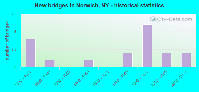
- New bridges - historical statistics
- 41930-1939
- 11940-1949
- 11960-1969
- 21980-1989
- 61990-1999
- 22000-2009
- 22010-2019

- Reconstructed bridges - Historical Statistics
- 21990-1999
- 02000-2009
- 22010-2019


- Bridge Condition - Deck
- 33.3%Very good
- 46.7%Good
- 20.0%Satisfactory

- Bridge Condition - Superstructure
- 37.5%Very good
- 37.5%Good
- 18.8%Satisfactory
- 6.3%Fair

- Bridge Condition - Substructure
- 6.3%Excellent
- 37.5%Very good
- 18.8%Good
- 37.5%Satisfactory

- Bridge Condition - Channel
- 5.6%Very good
- 44.4%Good
- 44.4%Satisfactory
- 5.6%Fair

- Bridge Condition - Culverts
- 50.0%Very good
- 50.0%Satisfactory
Find on map >> Show street view
Structure Number: 100934, Location: 2.9 MI S JCT RTS 12 & 23 (Lat: 42.496456, Lng: -75.529944), Route carried "on" structure: State highway 12, Year Built: 1999, Status: Open, Structure Length: 2.38m (7.81ft), Average Daily Traffic: 6,069 (year 2020), Truck Traffic: 9%, Average Future Daily Traffic: 6,190 (year 2040), Design Load: HS 25 or greater, Features Intersected: GILMORE BROOK
Minimum Vertical Clearance: 30+ m (98+ ft), Kilometerpoint: 42.059, Lanes on structure: 2, Base Highway Network: Yes, Owner: State Highway Agency, Approaching Roadway Width: 15.5m (50.9ft), Material/Design: Steel, Design/Construction: Stringer/Multi-beam, Number Of Spans In Main Unit: 1, Length of Maximum Span: 23.4m (76.8ft), Curb-To-Curb Width: 15.6m (51.2ft), Out-to-Out Width: 16.6m (54.5ft)
Condition: Deck: Good, Superstructure: Very good, Substructure: Very good, Channel: Good, Operating Rating: 77.1 metric tons, Method Used To Determine Operating Rating: Load Factor (LF), Inventory Rating: 46.3 metric tons, Method Used To Determine Inventory Rating: Load Factor (LF), Structural Evaluation: Equal to present desirable criteria, Deck Geometry: Superior to present desirable criteria, Waterway Adequacy: Somewhat better than minimum adequacy, Approach Roadway Alignment: Equal to present desirable criteria, Length Of Structure Improvement: 2.37m (7.78ft), Designated Inspection Frequency: Every 24 months, Inspection Date: May 2021, Bridge Improvement Cost: $982,000, Roadway Improvement Cost: $575,000, Total Project Cost: $1,558,000 ( Estimate for 2021), Deck Structure Type: Concrete Cast-file-Place, Wearing Surface/Protective System: Wearing Surface: Integral Concrete, Deck Protection: Epoxy Coated Reinforcing
Find on map >> Show street view
Structure Number: 100935, Location: 1.2 MI S JCT SH 12 & SH 2 (Lat: 42.519444, Lng: -75.522808), Route carried "on" structure: State highway 12, Year Built: 2000, Status: Open, Structure Length: 3.35m (10.99ft), Average Daily Traffic: 15,338 (year 2020), Truck Traffic: 5%, Average Future Daily Traffic: 15,644 (year 2040), Design Load: HS 25 or greater, Features Intersected: CANASAWACTA CREEK
Minimum Vertical Clearance: 30+ m (98+ ft), Kilometerpoint: 44.762, Lanes on structure: 2, Base Highway Network: Yes, Owner: State Highway Agency, Approaching Roadway Width: 11.9m (39.0ft), Skew: 23 degrees, Material/Design: Prestressed concrete, Design/Construction: Box Beam or Girders - Multiple, Number Of Spans In Main Unit: 1, Length of Maximum Span: 32.3m (106.0ft), Curb or Sidewalk Widths: Left: 1.5m (4.9ft), Right: 1.5m (4.9ft), Curb-To-Curb Width: 11.9m (39.0ft), Out-to-Out Width: 16.0m (52.5ft)
Condition: Deck: Good, Superstructure: Good, Substructure: Very good, Channel: Fair, Inventory Rating: 57.2 metric tons, Method Used To Determine Inventory Rating: Load Factor (LF), Structural Evaluation: Better than present minimum criteria, Deck Geometry: Somewhat better than minimum adequacy, Waterway Adequacy: Equal to present desirable criteria, Approach Roadway Alignment: Equal to present desirable criteria, Length Of Structure Improvement: 3.35m (10.99ft), Designated Inspection Frequency: Every 24 months, Inspection Date: June 2020, Bridge Improvement Cost: $1,466,000, Roadway Improvement Cost: $858,000, Total Project Cost: $2,324,000 ( Estimate for 2021), Deck Structure Type: Concrete Cast-file-Place, Wearing Surface/Protective System: Wearing Surface: Integral Concrete
Find on map >> Show street view
Structure Number: 101746, Location: 1 MI NW JCT SH 23 & SH 12 (Lat: 42.543422, Lng: -75.535150), Route carried "on" structure: State highway 23, Year Built: 1997, Status: Open, Structure Length: 6.28m (20.60ft), Average Daily Traffic: 1,993 (year 2019), Truck Traffic: 6%, Average Future Daily Traffic: 2,032 (year 2040), Design Load: HS 25 or greater, Features Intersected: CANASAWACTA CREEK
Minimum Vertical Clearance: 30+ m (98+ ft), Kilometerpoint: 34.706, Lanes on structure: 2, Base Highway Network: Yes, Owner: State Highway Agency, Approaching Roadway Width: 10.4m (34.1ft), Skew: 6 degrees, Material/Design: Steel continuous, Design/Construction: Stringer/Multi-beam, Number Of Spans In Main Unit: 2, Length of Maximum Span: 29.5m (96.8ft), Curb-To-Curb Width: 10.4m (34.1ft), Out-to-Out Width: 11.0m (36.1ft)
Condition: Deck: Good, Superstructure: Good, Substructure: Very good, Channel: Satisfactory, Operating Rating: 70.8 metric tons, Method Used To Determine Operating Rating: Load Factor (LF), Inventory Rating: 42.6 metric tons, Method Used To Determine Inventory Rating: Load Factor (LF), Structural Evaluation: Better than present minimum criteria, Deck Geometry: Equal to present minimum criteria, Waterway Adequacy: Somewhat better than minimum adequacy, Approach Roadway Alignment: Equal to present desirable criteria, Length Of Structure Improvement: 6.27m (20.57ft), Designated Inspection Frequency: Every 24 months, Inspection Date: August 2020, Bridge Improvement Cost: $2,007,000, Roadway Improvement Cost: $1,175,000, Total Project Cost: $3,182,000 ( Estimate for 2021), Deck Structure Type: Concrete Cast-file-Place, Wearing Surface/Protective System: Wearing Surface: Integral Concrete, Deck Protection: Epoxy Coated Reinforcing
Find on map >> Show street view
Structure Number: 101747, Location: JCT SH 23 & CHENANGO RIVE (Lat: 42.537875, Lng: -75.513744), Route carried "on" structure: State highway 23, Year Built: 1992, Status: Open, Structure Length: 4.05m (13.29ft), Average Daily Traffic: 4,429 (year 2020), Truck Traffic: 7%, Average Future Daily Traffic: 4,517 (year 2040), Design Load: HS 20, Features Intersected: CHENANGO RIVER
Minimum Vertical Clearance: 30+ m (98+ ft), Kilometerpoint: 37.136, Lanes on structure: 2, Base Highway Network: Yes, Owner: State Highway Agency, Approaching Roadway Width: 12.8m (42.0ft), Skew: 3 degrees, Material/Design: Steel, Design/Construction: Stringer/Multi-beam, Number Of Spans In Main Unit: 1, Length of Maximum Span: 38.7m (127.0ft), Curb or Sidewalk Widths: Left: 1.5m (4.9ft), Right: 0.0m, Curb-To-Curb Width: 10.7m (35.1ft), Out-to-Out Width: 12.8m (42.0ft)
Condition: Deck: Good, Superstructure: Good, Substructure: Good, Channel: Good, Operating Rating: 95.3 metric tons, Method Used To Determine Operating Rating: Load Factor (LF), Inventory Rating: 57.2 metric tons, Method Used To Determine Inventory Rating: Load Factor (LF), Structural Evaluation: Better than present minimum criteria, Deck Geometry: Somewhat better than minimum adequacy, Waterway Adequacy: Somewhat better than minimum adequacy, Approach Roadway Alignment: Equal to present desirable criteria, Length Of Structure Improvement: 4.05m (13.29ft), Designated Inspection Frequency: Every 24 months, Inspection Date: July 2020, Bridge Improvement Cost: $1,614,000, Roadway Improvement Cost: $945,000, Total Project Cost: $2,560,000 ( Estimate for 2021), Deck Structure Type: Concrete Cast-file-Place, Wearing Surface/Protective System: Wearing Surface: Integral Concrete, Deck Protection: Epoxy Coated Reinforcing
Find on map >> Show street view
Structure Number: 101748, Location: 1.4 MI NE JCT RTS 23 + 12 (Lat: 42.543067, Lng: -75.500467), Route carried "on" structure: State highway 23, Year Built: 1938, Status: Open, Structure Length: 1.22m (4.00ft), Average Daily Traffic: 3,918 (year 2020), Truck Traffic: 8%, Average Future Daily Traffic: 3,996 (year 2040), Design Load: H 20, Features Intersected: RANSFORD CREEK
Minimum Vertical Clearance: 30+ m (98+ ft), Kilometerpoint: 38.391, Lanes on structure: 2, Base Highway Network: Yes, Owner: State Highway Agency, Approaching Roadway Width: 12.2m (40.0ft), Skew: 4 degrees, Material/Design: Concrete, Design/Construction: Arch - Deck, Number Of Spans In Main Unit: 1, Length of Maximum Span: 11.8m (38.7ft), Curb-To-Curb Width: 12.8m (42.0ft), Out-to-Out Width: 23.8m (78.1ft)
Condition: Superstructure: Satisfactory, Substructure: Satisfactory, Channel: Satisfactory, Operating Rating: 59.9 metric tons, Method Used To Determine Operating Rating: Field evaluation and documented engineering judgment, Inventory Rating: 22.8 metric tons, Method Used To Determine Inventory Rating: Field evaluation and documented engineering judgment, Structural Evaluation: Equal to present minimum criteria, Deck Geometry: Equal to present minimum criteria, Waterway Adequacy: Somewhat better than minimum adequacy, Approach Roadway Alignment: Equal to present desirable criteria, Length Of Structure Improvement: 1.21m (3.97ft), Designated Inspection Frequency: Every 24 months, Inspection Date: August 2021, Bridge Improvement Cost: $573,000, Roadway Improvement Cost: $336,000, Total Project Cost: $909,000 ( Estimate for 2021)
Find on map >> Show street view
Structure Number: 104566, Location: 0.6 MI NW JCT RTS 319 &12 (Lat: 42.530453, Lng: -75.531197), Route carried "on" structure: County highway , Year Built: 1937, Year Reconstructed: 1997, Status: Open, Structure Length: 2.29m (7.51ft), Average Daily Traffic: 2,379 (year 2015), Truck Traffic: 5%, Average Future Daily Traffic: 2,943 (year 2040), Design Load: HS 25 or greater, Features Intersected: CANASAWACTA CREEK, Facility Carried by Structure: COUNTY ROAD 10A
Minimum Vertical Clearance: 30+ m (98+ ft), Kilometerpoint: 8.125, Lanes on structure: 2, Owner: County Highway Agency, Approaching Roadway Width: 14.0m (45.9ft), Skew: 1 degrees, Material/Design: Steel, Design/Construction: Stringer/Multi-beam, Number Of Spans In Main Unit: 1, Length of Maximum Span: 22.2m (72.8ft), Curb or Sidewalk Widths: Left: 0.0m, Right: 1.5m (4.9ft), Curb-To-Curb Width: 14.0m (45.9ft), Out-to-Out Width: 16.1m (52.8ft)
Condition: Deck: Very good, Superstructure: Good, Substructure: Satisfactory, Channel: Satisfactory, Operating Rating: 93.4 metric tons, Method Used To Determine Operating Rating: Load Factor (LF), Inventory Rating: 56.2 metric tons, Method Used To Determine Inventory Rating: Load Factor (LF), Structural Evaluation: Equal to present minimum criteria, Deck Geometry: Superior to present desirable criteria, Waterway Adequacy: Equal to present desirable criteria, Approach Roadway Alignment: Equal to present desirable criteria, Length Of Structure Improvement: 2.28m (7.48ft), Designated Inspection Frequency: Every 24 months, Inspection Date: April 2020, Bridge Improvement Cost: $1,571,000, Roadway Improvement Cost: $920,000, Total Project Cost: $2,492,000 ( Estimate for 2021), Deck Structure Type: Concrete Cast-file-Place, Wearing Surface/Protective System: Wearing Surface: Integral Concrete, Deck Protection: Epoxy Coated Reinforcing
Find on map >> Show street view
Structure Number: 104567, Location: JCT SH 320 & CHENANGO RIV (Lat: 42.553472, Lng: -75.523156), Route carried "on" structure: State highway 320, Year Built: 1994, Status: Open, Structure Length: 4.79m (15.72ft), Average Daily Traffic: 3,677 (year 2020), Truck Traffic: 8%, Average Future Daily Traffic: 4,549 (year 2040), Design Load: HS 25 or greater, Features Intersected: CHENANGO RIVER
Minimum Vertical Clearance: 30+ m (98+ ft), Kilometerpoint: 0.193, Lanes on structure: 2, Base Highway Network: Yes, Owner: State Highway Agency, Approaching Roadway Width: 10.4m (34.1ft), Material/Design: Steel, Design/Construction: Stringer/Multi-beam, Number Of Spans In Main Unit: 1, Length of Maximum Span: 47.2m (154.9ft), Curb-To-Curb Width: 10.4m (34.1ft), Out-to-Out Width: 11.0m (36.1ft)
Condition: Deck: Satisfactory, Superstructure: Satisfactory, Substructure: Good, Channel: Good, Operating Rating: 85.3 metric tons, Method Used To Determine Operating Rating: Load Factor (LF), Inventory Rating: 50.8 metric tons, Method Used To Determine Inventory Rating: Load Factor (LF), Structural Evaluation: Equal to present minimum criteria, Deck Geometry: Somewhat better than minimum adequacy, Waterway Adequacy: Equal to present desirable criteria, Approach Roadway Alignment: Equal to present desirable criteria, Length Of Structure Improvement: 4.78m (15.68ft), Designated Inspection Frequency: Every 24 months, Inspection Date: May 2020, Bridge Improvement Cost: $1,343,000, Roadway Improvement Cost: $786,000, Total Project Cost: $2,129,000 ( Estimate for 2021), Deck Structure Type: Concrete Cast-file-Place, Wearing Surface/Protective System: Wearing Surface: Integral Concrete, Deck Protection: Epoxy Coated Reinforcing
Find on map >> Show street view
Structure Number: 104568, Location: 11 MI NE JCT RTE 320 + 12 (Lat: 42.559306, Lng: -75.507869), Route carried "on" structure: State highway 320, Year Built: 2010, Status: Open, Structure Length: 2.32m (7.61ft), Average Daily Traffic: 1,709 (year 2017), Truck Traffic: 5%, Average Future Daily Traffic: 2,393 (year 2037), Design Load: HL 93, Features Intersected: THOMPSON CREEK
Minimum Vertical Clearance: 30+ m (98+ ft), Kilometerpoint: 1.657, Lanes on structure: 2, Base Highway Network: Yes, Owner: State Highway Agency, Approaching Roadway Width: 9.1m (29.9ft), Skew: 3 degrees, Material/Design: Prestressed concrete, Design/Construction: Stringer/Multi-beam, Number Of Spans In Main Unit: 1, Length of Maximum Span: 22.8m (74.8ft), Curb-To-Curb Width: 9.6m (31.5ft), Out-to-Out Width: 10.2m (33.5ft)
Condition: Deck: Good, Superstructure: Good, Substructure: Very good, Channel: Satisfactory, Operating Rating: 75.3 metric tons, Method Used To Determine Operating Rating: Load Factor (LF), Inventory Rating: 44.5 metric tons, Method Used To Determine Inventory Rating: Load Factor (LF), Structural Evaluation: Better than present minimum criteria, Deck Geometry: Somewhat better than minimum adequacy, Waterway Adequacy: Somewhat better than minimum adequacy, Approach Roadway Alignment: Equal to present desirable criteria, Length Of Structure Improvement: 2.31m (7.58ft), Designated Inspection Frequency: Every 24 months, Inspection Date: October 2020, Bridge Improvement Cost: $700,000, Roadway Improvement Cost: $410,000, Total Project Cost: $1,110,000 ( Estimate for 2021), Deck Structure Type: Concrete Cast-file-Place, Wearing Surface/Protective System: Wearing Surface: Integral Concrete
Find on map >> Show street view
Structure Number: 105052, Location: JCT RTE 990M + CHENANGO R (Lat: 42.532758, Lng: -75.506456), Route carried "on" structure: Bypass State highway 990L, Year Built: 1961, Status: Open, Structure Length: 6.13m (20.11ft), Average Daily Traffic: 4,062 (year 2018), Truck Traffic: 7%, Average Future Daily Traffic: 4,934 (year 2040), Design Load: H 20, Features Intersected: CHENANGO RIVER
Minimum Vertical Clearance: 30+ m (98+ ft), Kilometerpoint: 1.400, Lanes on structure: 2, Base Highway Network: Yes, Owner: State Highway Agency, Approaching Roadway Width: 9.1m (29.9ft), Skew: 1 degrees, Material/Design: Steel, Design/Construction: Stringer/Multi-beam, Number Of Spans In Main Unit: 3, Length of Maximum Span: 26.5m (86.9ft), Curb or Sidewalk Widths: Left: 1.4m (4.6ft), Right: 1.4m (4.6ft), Curb-To-Curb Width: 9.1m (29.9ft), Out-to-Out Width: 12.6m (41.3ft)
Condition: Deck: Satisfactory, Superstructure: Fair, Substructure: Satisfactory, Channel: Good, Operating Rating: 42.6 metric tons, Method Used To Determine Operating Rating: Load Factor (LF), Inventory Rating: 25.4 metric tons, Method Used To Determine Inventory Rating: Load Factor (LF), Structural Evaluation: Somewhat better than minimum adequacy, Deck Geometry: Meets minimum limits, Waterway Adequacy: Somewhat better than minimum adequacy, Approach Roadway Alignment: Equal to present desirable criteria, Length Of Structure Improvement: 6.12m (20.08ft), Designated Inspection Frequency: Every 24 months, Inspection Date: June 2020, Bridge Improvement Cost: $1,679,000, Roadway Improvement Cost: $984,000, Total Project Cost: $2,663,000 ( Estimate for 2021), Deck Structure Type: Concrete Cast-file-Place, Wearing Surface/Protective System: Wearing Surface: Bituminous, Membrane: Preformed Fabric
Find on map >> Show street view
Structure Number: 335078, Location: 0.6 MI SO OF NORWICH (Lat: 42.515247, Lng: -75.508694), Route carried "on" structure: County highway , Year Built: 2001, Status: Open, Structure Length: 1.95m (6.40ft), Average Daily Traffic: 2,433 (year 2016), Truck Traffic: 9%, Average Future Daily Traffic: 3,010 (year 2040), Design Load: HS 25 or greater, Features Intersected: JOHNSON CREEK, Facility Carried by Structure: COUNTY ROAD NO 32
Minimum Vertical Clearance: 30+ m (98+ ft), Kilometerpoint: 9.847, Lanes on structure: 2, Owner: County Highway Agency, Approaching Roadway Width: 14.0m (45.9ft), Skew: 20 degrees, Material/Design: Prestressed concrete, Design/Construction: Box Beam or Girders - Multiple, Number Of Spans In Main Unit: 1, Length of Maximum Span: 18.3m (60.0ft), Curb-To-Curb Width: 14.0m (45.9ft), Out-to-Out Width: 15.1m (49.5ft)
Condition: Deck: Satisfactory, Superstructure: Satisfactory, Substructure: Satisfactory, Channel: Satisfactory, Operating Rating: 85.6 metric tons, Method Used To Determine Operating Rating: Field evaluation and documented engineering judgment, Inventory Rating: 40.8 metric tons, Method Used To Determine Inventory Rating: Field evaluation and documented engineering judgment, Structural Evaluation: Equal to present minimum criteria, Deck Geometry: Superior to present desirable criteria, Waterway Adequacy: Meets minimum limits, Approach Roadway Alignment: Somewhat better than minimum adequacy, Length Of Structure Improvement: 1.95m (6.40ft), Designated Inspection Frequency: Every 24 months, Inspection Date: June 2020, Bridge Improvement Cost: $671,000, Roadway Improvement Cost: $393,000, Total Project Cost: $1,064,000 ( Estimate for 2021), Deck Structure Type: Concrete Cast-file-Place, Wearing Surface/Protective System: Wearing Surface: Monolithic Concrete, Deck Protection: Epoxy Coated Reinforcing
Find on map >> Show street view
Structure Number: 335079, Location: 0.1 MI EAST OF NORWICH (Lat: 42.521889, Lng: -75.512497), Route carried "on" structure: County highway , Year Built: 1986, Status: Open, Structure Length: 0.73m (2.40ft), Average Daily Traffic: 4,504 (year 2018), Truck Traffic: 5%, Average Future Daily Traffic: 5,572 (year 2040), Design Load: HS 20, Features Intersected: CHENANGO R OVERFL, Facility Carried by Structure: CR32A HALE ST
Minimum Vertical Clearance: 30+ m (98+ ft), Kilometerpoint: 0.016, Lanes on structure: 2, Owner: County Highway Agency, Approaching Roadway Width: 7.9m (25.9ft), Material/Design: Aluminum, Iron, Design/Construction: Culvert, Number Of Spans In Main Unit: 1, Length of Maximum Span: 7.0m (23.0ft), Curb or Sidewalk Widths: Left: 0.0m, Right: 1.5m (4.9ft)
Condition: Channel: Satisfactory, Culverts: Very good, Operating Rating: 77.6 metric tons, Method Used To Determine Operating Rating: Field evaluation and documented engineering judgment, Inventory Rating: 32.7 metric tons, Method Used To Determine Inventory Rating: Field evaluation and documented engineering judgment, Structural Evaluation: Equal to present desirable criteria, Waterway Adequacy: Meets minimum limits, Approach Roadway Alignment: Equal to present desirable criteria, Length Of Structure Improvement: 0.73m (2.40ft), Designated Inspection Frequency: Every 24 months, Inspection Date: June 2020, Bridge Improvement Cost: $103,000, Roadway Improvement Cost: $60,000, Total Project Cost: $163,000 ( Estimate for 2021)
Find on map >> Show street view
Structure Number: 335081, Location: 0.24 MI NE OF NORWICH (Lat: 42.540381, Lng: -75.509389), Route carried "on" structure: County highway , Year Built: 1938, Year Reconstructed: 2019, Status: Open, Structure Length: 0.70m (2.30ft), Average Daily Traffic: 5,968 (year 2018), Truck Traffic: 8%, Average Future Daily Traffic: 7,249 (year 2040), Features Intersected: RANSFORD CREEK, Facility Carried by Structure: COUNTY ROAD NO 32
Minimum Vertical Clearance: 30+ m (98+ ft), Kilometerpoint: 1.062, Lanes on structure: 2, Owner: County Highway Agency, Approaching Roadway Width: 12.2m (40.0ft), Material/Design: Concrete, Design/Construction: Slab, Number Of Spans In Main Unit: 1, Length of Maximum Span: 6.0m (19.7ft), Curb-To-Curb Width: 12.2m (40.0ft), Out-to-Out Width: 12.4m (40.7ft)
Condition: Deck: Good, Superstructure: Good, Substructure: Satisfactory, Channel: Good, Operating Rating: 98.9 metric tons, Method Used To Determine Operating Rating: Allowable Stress (AS), Inventory Rating: 70.8 metric tons, Method Used To Determine Inventory Rating: Allowable Stress (AS), Structural Evaluation: Equal to present minimum criteria, Deck Geometry: Somewhat better than minimum adequacy, Waterway Adequacy: Meets minimum limits, Approach Roadway Alignment: Equal to present desirable criteria, Length Of Structure Improvement: 0.70m (2.30ft), Designated Inspection Frequency: Every 24 months, Inspection Date: July 2020, Bridge Improvement Cost: $341,000, Roadway Improvement Cost: $200,000, Total Project Cost: $541,000 ( Estimate for 2021), Deck Structure Type: Concrete Cast-file-Place, Wearing Surface/Protective System: Wearing Surface: Bituminous
Find on map >> Show street view
Structure Number: 335082, Location: 0.7 MI NE OF NORWICH (Lat: 42.552975, Lng: -75.517278), Route carried "on" structure: County highway , Year Built: 1938, Year Reconstructed: 2019, Status: Open, Structure Length: 1.16m (3.81ft), Average Daily Traffic: 5,169 (year 2018), Truck Traffic: 8%, Average Future Daily Traffic: 6,279 (year 2040), Design Load: HS 20, Features Intersected: THOMPSON CREEK, Facility Carried by Structure: COUNTY ROAD 32
Minimum Vertical Clearance: 30+ m (98+ ft), Kilometerpoint: 1.641, Lanes on structure: 2, Owner: County Highway Agency, Approaching Roadway Width: 6.1m (20.0ft), Material/Design: Steel, Design/Construction: Stringer/Multi-beam, Number Of Spans In Main Unit: 1, Length of Maximum Span: 11.2m (36.7ft), Curb-To-Curb Width: 11.0m (36.1ft), Out-to-Out Width: 12.0m (39.4ft)
Condition: Deck: Very good, Superstructure: Very good, Substructure: Very good, Channel: Very good, Operating Rating: 60.8 metric tons, Method Used To Determine Operating Rating: Allowable Stress (AS), Inventory Rating: 33.6 metric tons, Method Used To Determine Inventory Rating: Allowable Stress (AS), Structural Evaluation: Equal to present desirable criteria, Deck Geometry: Meets minimum limits, Waterway Adequacy: Meets minimum limits, Approach Roadway Alignment: Equal to present desirable criteria, Length Of Structure Improvement: 1.15m (3.77ft), Designated Inspection Frequency: Every 24 months, Inspection Date: June 2020, Bridge Improvement Cost: $592,000, Roadway Improvement Cost: $347,000, Total Project Cost: $939,000 ( Estimate for 2021), Deck Structure Type: Concrete Cast-file-Place, Wearing Surface/Protective System: Wearing Surface: Bituminous
Find on map >> Show street view
Structure Number: 335084, Location: 2.3 MI. S.W. OF NORWICH (Lat: 42.523889, Lng: -75.555039), Route carried "on" structure: Other road , Year Built: 1985, Status: Open, Structure Length: 1.04m (3.41ft), Average Daily Traffic: 207 (year 2016), Truck Traffic: 2%, Average Future Daily Traffic: 290 (year 2036), Features Intersected: GILMORE BROOK, Facility Carried by Structure: MANLEY ROAD
Minimum Vertical Clearance: 30+ m (98+ ft), Kilometerpoint: 0.837, Lanes on structure: 2, Owner: County Highway Agency, Approaching Roadway Width: 7.6m (24.9ft), Material/Design: Steel, Design/Construction: Culvert, Number Of Spans In Main Unit: 2, Length of Maximum Span: 3.9m (12.8ft)
Condition: Channel: Good, Culverts: Satisfactory, Operating Rating: 75.4 metric tons, Method Used To Determine Operating Rating: Field evaluation and documented engineering judgment, Inventory Rating: 32.7 metric tons, Method Used To Determine Inventory Rating: Field evaluation and documented engineering judgment, Structural Evaluation: Equal to present minimum criteria, Waterway Adequacy: Somewhat better than minimum adequacy, Approach Roadway Alignment: Equal to present desirable criteria, Length Of Structure Improvement: 1.03m (3.38ft), Designated Inspection Frequency: Every 24 months, Inspection Date: July 2021, Bridge Improvement Cost: $140,000, Roadway Improvement Cost: $82,000, Total Project Cost: $222,000 ( Estimate for 2021)
Find on map >> Show street view
Structure Number: 335085, Location: 3 MI SW OF NORWICH (Lat: 42.504628, Lng: -75.540942), Route carried "on" structure: Other road , Year Built: 1998, Status: Open, Structure Length: 2.13m (6.99ft), Average Daily Traffic: 306 (year 2016), Truck Traffic: 2%, Average Future Daily Traffic: 428 (year 2036), Design Load: HS 25 or greater, Features Intersected: GILMORE BROOK, Facility Carried by Structure: LOWER RAVINE ROAD
Minimum Vertical Clearance: 30+ m (98+ ft), Kilometerpoint: 1.094, Lanes on structure: 2, Owner: County Highway Agency, Approaching Roadway Width: 8.5m (27.9ft), Skew: 3 degrees, Material/Design: Prestressed concrete, Design/Construction: Box Beam or Girders - Multiple, Number Of Spans In Main Unit: 1, Length of Maximum Span: 20.7m (67.9ft), Curb-To-Curb Width: 8.6m (28.2ft), Out-to-Out Width: 8.6m (28.2ft)
Condition: Deck: Very good, Superstructure: Very good, Substructure: Excellent, Channel: Good, Operating Rating: 77.1 metric tons, Method Used To Determine Operating Rating: Load Factor (LF), Inventory Rating: 46.3 metric tons, Method Used To Determine Inventory Rating: Load Factor (LF), Structural Evaluation: Equal to present desirable criteria, Deck Geometry: Equal to present minimum criteria, Waterway Adequacy: Equal to present minimum criteria, Approach Roadway Alignment: Equal to present desirable criteria, Length Of Structure Improvement: 2.13m (6.99ft), Designated Inspection Frequency: Every 24 months, Inspection Date: June 2020, Bridge Improvement Cost: $541,000, Roadway Improvement Cost: $317,000, Total Project Cost: $858,000 ( Estimate for 2021), Wearing Surface/Protective System: Wearing Surface: Bituminous
Find on map >> Show street view
Structure Number: 335086, Location: 1.5 MI SE OF NORWICH (Lat: 42.513867, Lng: -75.495344), Route carried "on" structure: County highway , Year Built: 2010, Status: Open, Structure Length: 1.13m (3.71ft), Average Daily Traffic: 819 (year 2018), Truck Traffic: 7%, Average Future Daily Traffic: 1,013 (year 2040), Design Load: HS 25 or greater, Features Intersected: JOHNSON CREEK, Facility Carried by Structure: COUNTY ROAD 34
Minimum Vertical Clearance: 30+ m (98+ ft), Kilometerpoint: 0.611, Lanes on structure: 2, Owner: County Highway Agency, Approaching Roadway Width: 10.4m (34.1ft), Skew: 4 degrees, Material/Design: Concrete, Design/Construction: Frame, Number Of Spans In Main Unit: 1, Length of Maximum Span: 10.4m (34.1ft), Curb-To-Curb Width: 10.1m (33.1ft), Out-to-Out Width: 11.2m (36.7ft)
Condition: Deck: Very good, Superstructure: Very good, Substructure: Very good, Channel: Good, Operating Rating: 79.9 metric tons, Method Used To Determine Operating Rating: Field evaluation and documented engineering judgment, Inventory Rating: 40.8 metric tons, Method Used To Determine Inventory Rating: Field evaluation and documented engineering judgment, Structural Evaluation: Equal to present desirable criteria, Deck Geometry: Equal to present minimum criteria, Waterway Adequacy: Meets minimum limits, Approach Roadway Alignment: Somewhat better than minimum adequacy, Length Of Structure Improvement: 1.12m (3.67ft), Designated Inspection Frequency: Every 24 months, Inspection Date: July 2020, Bridge Improvement Cost: $444,000, Roadway Improvement Cost: $260,000, Total Project Cost: $704,000 ( Estimate for 2021), Wearing Surface/Protective System: Wearing Surface: Bituminous, Membrane: Other
Find on map >> Show street view
Structure Number: 335087, Location: 1.1 MI SE OF NORWICH (Lat: 42.513722, Lng: -75.499469), Route carried "on" structure: County highway , Year Built: 1946, Year Reconstructed: 1998, Status: Open, Structure Length: 1.25m (4.10ft), Average Daily Traffic: 819 (year 2018), Truck Traffic: 7%, Average Future Daily Traffic: 1,013 (year 2040), Design Load: HS 25 or greater, Features Intersected: JOHNSON CREEK, Facility Carried by Structure: COUNTY ROAD 34
Minimum Vertical Clearance: 30+ m (98+ ft), Kilometerpoint: 0.644, Lanes on structure: 2, Owner: County Highway Agency, Approaching Roadway Width: 8.5m (27.9ft), Skew: 6 degrees, Material/Design: Prestressed concrete, Design/Construction: Box Beam or Girders - Multiple, Number Of Spans In Main Unit: 1, Length of Maximum Span: 11.8m (38.7ft), Curb-To-Curb Width: 8.6m (28.2ft), Out-to-Out Width: 8.6m (28.2ft)
Condition: Deck: Very good, Superstructure: Very good, Substructure: Satisfactory, Channel: Satisfactory, Operating Rating: 76.2 metric tons, Method Used To Determine Operating Rating: Load Factor (LF), Inventory Rating: 45.4 metric tons, Method Used To Determine Inventory Rating: Load Factor (LF), Structural Evaluation: Equal to present minimum criteria, Deck Geometry: Somewhat better than minimum adequacy, Waterway Adequacy: Meets minimum limits, Approach Roadway Alignment: Equal to present desirable criteria, Length Of Structure Improvement: 1.24m (4.07ft), Designated Inspection Frequency: Every 24 months, Inspection Date: July 2020, Bridge Improvement Cost: $449,000, Roadway Improvement Cost: $263,000, Total Project Cost: $711,000 ( Estimate for 2021), Wearing Surface/Protective System: Wearing Surface: Bituminous, Membrane: Other
Find on map >> Show street view
Structure Number: 335088, Location: 0.8 MI.SE OF NORWICH (Lat: 42.515094, Lng: -75.504781), Route carried "on" structure: Other road , Year Built: 1991, Status: Open, Structure Length: 1.80m (5.91ft), Average Daily Traffic: 3,993 (year 2018), Truck Traffic: 4%, Average Future Daily Traffic: 4,850 (year 2040), Design Load: HS 20, Features Intersected: JOHNSON CREEK, Facility Carried by Structure: COUNTY ROAD 33
Minimum Vertical Clearance: 30+ m (98+ ft), Kilometerpoint: 0.306, Lanes on structure: 2, Owner: County Highway Agency, Approaching Roadway Width: 10.4m (34.1ft), Material/Design: Steel, Design/Construction: Stringer/Multi-beam, Number Of Spans In Main Unit: 1, Length of Maximum Span: 16.7m (54.8ft), Curb-To-Curb Width: 10.4m (34.1ft), Out-to-Out Width: 11.0m (36.1ft)
Condition: Deck: Good, Superstructure: Very good, Substructure: Good, Channel: Satisfactory, Inventory Rating: 59.9 metric tons, Method Used To Determine Inventory Rating: Load Factor (LF), Structural Evaluation: Better than present minimum criteria, Deck Geometry: Somewhat better than minimum adequacy, Waterway Adequacy: Meets minimum limits, Approach Roadway Alignment: Equal to present desirable criteria, Length Of Structure Improvement: 1.79m (5.87ft), Designated Inspection Frequency: Every 24 months, Inspection Date: April 2021, Bridge Improvement Cost: $682,000, Roadway Improvement Cost: $399,000, Total Project Cost: $1,081,000 ( Estimate for 2021), Deck Structure Type: Concrete Cast-file-Place, Wearing Surface/Protective System: Wearing Surface: Bituminous, Deck Protection: Epoxy Coated Reinforcing