Bridge Statistics for North Massapequa, New York (NY)
Condition, Traffic, Stress, Structural Evaluation, Project Costs
- National Bridge Inventory (NBI) Statistics
- 19Number of bridges
- 66ft / 19.8mTotal length
- $47,082,000Total costs
- 1,207,180Total average daily traffic
- 6,182Total average daily truck traffic
- National Bridge Inventory (NBI) Registered Bridges for North Massapequa
- No street view available for this location
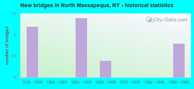
- New bridges - historical statistics
- 61930-1939
- 71950-1959
- 21960-1969
- 41990-1999
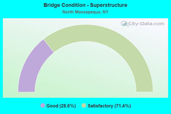
- Bridge Condition - Superstructure
- 28.6%Good
- 71.4%Satisfactory
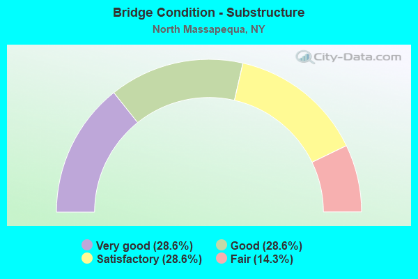
- Bridge Condition - Substructure
- 28.6%Very good
- 28.6%Good
- 28.6%Satisfactory
- 14.3%Fair
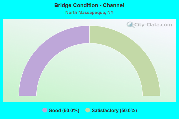
- Bridge Condition - Channel
- 50.0%Good
- 50.0%Satisfactory

- Bridge Condition - Culverts
- 50.0%Good
- 50.0%Satisfactory
Find on map >> Show street view
Structure Number: 1036849, Location: .8 MI N JCT RTS 135+SSP (Lat: 40.711067, Lng: -73.482894), Route carried "on" structure: State highway 135, Year Built: 1965, Status: Open, Structure Length: 5.36m (17.59ft), Average Daily Traffic: 73,484 (year 2018), Truck Traffic: 5%, Average Future Daily Traffic: 87,409 (year 2040), Design Load: H 20, Features Intersected: RTE 107
Minimum Vertical Clearance: 30+ m (98+ ft), Kilometerpoint: 5.294, Lanes on structure: 6, Lanes under structure: 4, Base Highway Network: Yes, Owner: State Highway Agency, Approaching Roadway Width: 29.9m (98.1ft), Skew: 25 degrees, Material/Design: Steel, Design/Construction: Stringer/Multi-beam, Number Of Spans In Main Unit: 2, Length of Maximum Span: 26.5m (86.9ft), Curb-To-Curb Width: 25.9m (85.0ft), Out-to-Out Width: 29.0m (95.1ft)
Condition: Deck: Satisfactory, Superstructure: Satisfactory, Substructure: Fair, Operating Rating: 71.7 metric tons, Method Used To Determine Operating Rating: Load Factor (LF), Inventory Rating: 42.6 metric tons, Method Used To Determine Inventory Rating: Load Factor (LF), Structural Evaluation: Somewhat better than minimum adequacy, Deck Geometry: Meets minimum limits, Underclear: Somewhat better than minimum adequacy, Approach Roadway Alignment: Better than present minimum criteria, Length Of Structure Improvement: 5.36m (17.59ft), Designated Inspection Frequency: Every 24 months, Inspection Date: July 2021, Bridge Improvement Cost: $8,903,000, Roadway Improvement Cost: $5,213,000, Total Project Cost: $14,116,000 ( Estimate for 2021), Deck Structure Type: Concrete Cast-file-Place, Wearing Surface/Protective System: Wearing Surface: Bituminous, Membrane: Preformed Fabric
Find on map >> Show street view
Structure Number: 1056589, Location: .5 MI E JCT RTS 107+SSP (Lat: 40.705653, Lng: -73.451347), Route carried "on" structure: State highway 908M, Year Built: 1959, Status: Open, Structure Length: 0.91m (2.99ft), Average Daily Traffic: 154,832 (year 2020), Average Future Daily Traffic: 184,172 (year 2040), Design Load: HS 20, Features Intersected: MASSAPEQUA CREEK
Minimum Vertical Clearance: 30+ m (98+ ft), Kilometerpoint: 24.972, Lanes on structure: 7, Base Highway Network: Yes, Owner: State Highway Agency, Approaching Roadway Width: 48.5m (159.1ft), Skew: 20 degrees, Material/Design: Concrete continuous, Design/Construction: Culvert, Number Of Spans In Main Unit: 2, Length of Maximum Span: 4.2m (13.8ft), Curb or Sidewalk Widths: Left: 1.2m (3.9ft), Right: 2.6m (8.5ft), Curb-To-Curb Width: 48.5m (159.1ft), Out-to-Out Width: 56.5m (185.4ft)
Condition: Channel: Satisfactory, Culverts: Satisfactory, Operating Rating: 43.5 metric tons, Method Used To Determine Operating Rating: Load Factor (LF), Inventory Rating: 26.3 metric tons, Method Used To Determine Inventory Rating: Load Factor (LF), Structural Evaluation: Equal to present minimum criteria, Deck Geometry: Superior to present desirable criteria, Waterway Adequacy: Superior to present desirable criteria, Approach Roadway Alignment: Equal to present desirable criteria, Length Of Structure Improvement: 0.91m (2.99ft), Designated Inspection Frequency: Every 24 months, Inspection Date: September 2020, Bridge Improvement Cost: $1,750,000, Roadway Improvement Cost: $1,025,000, Total Project Cost: $2,774,000 ( Estimate for 2021)
Find on map >> Show street view
Structure Number: 105771, Location: 1.5 MI E JCT RTS 135+SSP (Lat: 40.705986, Lng: -73.461264), Route carried "on" structure: Other road , Year Built: 1957, Status: Open, Structure Length: 2.29m (7.51ft), Average Daily Traffic: 18,265 (year 2020), Truck Traffic: 3%, Average Future Daily Traffic: 22,188 (year 2040), Features Intersected: RTE 908M, Facility Carried by Structure: NORTH BROADWAY
Minimum Vertical Clearance: 30+ m (98+ ft), Kilometerpoint: 3.894, Lanes on structure: 4, Lanes under structure: 4, Owner: State Highway Agency, Approaching Roadway Width: 16.2m (53.1ft), Skew: 1 degrees, Material/Design: Concrete, Design/Construction: Arch - Deck, Number Of Spans In Main Unit: 1, Length of Maximum Span: 21.3m (69.9ft), Curb or Sidewalk Widths: Left: 1.4m (4.6ft), Right: 1.4m (4.6ft), Curb-To-Curb Width: 16.2m (53.1ft), Out-to-Out Width: 20.7m (67.9ft)
Condition: Superstructure: Good, Substructure: Good, Operating Rating: 87.8 metric tons, Method Used To Determine Operating Rating: Field evaluation and documented engineering judgment, Inventory Rating: 32.7 metric tons, Method Used To Determine Inventory Rating: Field evaluation and documented engineering judgment, Structural Evaluation: Better than present minimum criteria, Deck Geometry: Meets minimum limits, Underclear: High priority of corrective action, Approach Roadway Alignment: Equal to present desirable criteria, Length Of Structure Improvement: 2.28m (7.48ft), Designated Inspection Frequency: Every 24 months, Inspection Date: July 2021, Bridge Improvement Cost: $3,884,000, Roadway Improvement Cost: $2,275,000, Total Project Cost: $6,159,000 ( Estimate for 2021), Wearing Surface/Protective System: Wearing Surface: Bituminous
Find on map >> Show street view
Structure Number: 105772, Location: .5 MI E JCT RTS 107+SSP (Lat: 40.705972, Lng: -73.452681), Route carried "on" structure: State highway 907E, Year Built: 1957, Status: Open, Structure Length: 1.88m (6.17ft), Average Daily Traffic: 7,312 (year 2020), Average Future Daily Traffic: 8,697 (year 2040), Design Load: H 20, Features Intersected: RTE 908M
Minimum Vertical Clearance: 30+ m (98+ ft), Kilometerpoint: 0.209, Lanes on structure: 2, Lanes under structure: 3, Base Highway Network: Yes, Owner: State Highway Agency, Approaching Roadway Width: 9.7m (31.8ft), Material/Design: Concrete, Design/Construction: Arch - Deck, Number Of Spans In Main Unit: 1, Length of Maximum Span: 17.3m (56.8ft), Curb or Sidewalk Widths: Left: 1.8m (5.9ft), Right: 4.4m (14.4ft), Curb-To-Curb Width: 9.8m (32.2ft), Out-to-Out Width: 18.9m (62.0ft)
Condition: Superstructure: Good, Substructure: Very good, Operating Rating: 55.7 metric tons, Method Used To Determine Operating Rating: Field evaluation and documented engineering judgment, Inventory Rating: 22.3 metric tons, Method Used To Determine Inventory Rating: Field evaluation and documented engineering judgment, Structural Evaluation: Somewhat better than minimum adequacy, Deck Geometry: Meets minimum limits, Underclear: High priority of corrective action, Approach Roadway Alignment: Better than present minimum criteria, Length Of Structure Improvement: 1.88m (6.17ft), Designated Inspection Frequency: Every 24 months, Inspection Date: January 2020, Bridge Improvement Cost: $3,029,000, Roadway Improvement Cost: $1,774,000, Total Project Cost: $4,803,000 ( Estimate for 2021), Wearing Surface/Protective System: Wearing Surface: Bituminous
Find on map >> Show street view
Structure Number: 1059691, Location: JCT RTS 107+SSP (Lat: 40.703056, Lng: -73.482469), Route carried "on" structure: State highway 908M, Year Built: 1957, Status: Open, Structure Length: 2.13m (6.99ft), Average Daily Traffic: 70,734 (year 2019), Truck Traffic: 1%, Average Future Daily Traffic: 84,138 (year 2040), Design Load: H 20, Features Intersected: RTE 107
Minimum Vertical Clearance: 30+ m (98+ ft), Kilometerpoint: 22.285, Lanes on structure: 4, Lanes under structure: 3, Base Highway Network: Yes, Owner: State Highway Agency, Approaching Roadway Width: 14.6m (47.9ft), Material/Design: Concrete, Design/Construction: Frame, Number Of Spans In Main Unit: 1, Length of Maximum Span: 20.1m (65.9ft), Curb-To-Curb Width: 16.1m (52.8ft), Out-to-Out Width: 17.3m (56.8ft)
Condition: Deck: Satisfactory, Superstructure: Satisfactory, Substructure: Satisfactory, Operating Rating: 57.8 metric tons, Method Used To Determine Operating Rating: Field evaluation and documented engineering judgment, Inventory Rating: 20.7 metric tons, Method Used To Determine Inventory Rating: Field evaluation and documented engineering judgment, Structural Evaluation: Somewhat better than minimum adequacy, Deck Geometry: High priority of replacement, Underclear: Meets minimum limits, Approach Roadway Alignment: Better than present minimum criteria, Length Of Structure Improvement: 2.13m (6.99ft), Designated Inspection Frequency: Every 24 months, Inspection Date: January 2020, Bridge Improvement Cost: $2,423,000, Roadway Improvement Cost: $1,419,000, Total Project Cost: $3,842,000 ( Estimate for 2021), Wearing Surface/Protective System: Wearing Surface: Bituminous, Membrane: Preformed Fabric
Find on map >> Show street view
Structure Number: 1059692, Location: JCT RTS 107+SSP (Lat: 40.702892, Lng: -73.482433), Route carried "on" structure: State highway 908M, Year Built: 1934, Status: Open, Structure Length: 2.13m (6.99ft), Average Daily Traffic: 70,734 (year 2019), Truck Traffic: 1%, Average Future Daily Traffic: 84,138 (year 2040), Design Load: H 20, Features Intersected: RTE 107
Minimum Vertical Clearance: 30+ m (98+ ft), Kilometerpoint: 22.285, Lanes on structure: 4, Lanes under structure: 3, Base Highway Network: Yes, Owner: State Highway Agency, Approaching Roadway Width: 14.6m (47.9ft), Material/Design: Concrete, Design/Construction: Frame, Number Of Spans In Main Unit: 1, Length of Maximum Span: 20.1m (65.9ft), Curb-To-Curb Width: 16.1m (52.8ft), Out-to-Out Width: 17.3m (56.8ft)
Condition: Deck: Satisfactory, Superstructure: Satisfactory, Substructure: Satisfactory, Operating Rating: 58.7 metric tons, Method Used To Determine Operating Rating: Field evaluation and documented engineering judgment, Inventory Rating: 23.0 metric tons, Method Used To Determine Inventory Rating: Field evaluation and documented engineering judgment, Structural Evaluation: Somewhat better than minimum adequacy, Deck Geometry: High priority of replacement, Underclear: High priority of corrective action, Approach Roadway Alignment: Better than present minimum criteria, Length Of Structure Improvement: 2.13m (6.99ft), Designated Inspection Frequency: Every 24 months, Inspection Date: January 2020, Bridge Improvement Cost: $2,423,000, Roadway Improvement Cost: $1,419,000, Total Project Cost: $3,842,000 ( Estimate for 2021), Wearing Surface/Protective System: Wearing Surface: Bituminous, Membrane: Preformed Fabric
Find on map >> Show street view
Structure Number: 105971, Location: 1.5 MI E JCT RTS 135+SSP (Lat: 40.705772, Lng: -73.461317), Route carried "on" structure: Other road , Year Built: 1930, Status: Open, Structure Length: 2.10m (6.89ft), Average Daily Traffic: 18,265 (year 2020), Truck Traffic: 3%, Average Future Daily Traffic: 22,188 (year 2040), Features Intersected: RTE 908M, Facility Carried by Structure: NORTH BROADWAY
Minimum Vertical Clearance: 30+ m (98+ ft), Kilometerpoint: 3.862, Lanes on structure: 4, Lanes under structure: 3, Owner: State Highway Agency, Approaching Roadway Width: 16.2m (53.1ft), Skew: 1 degrees, Material/Design: Concrete, Design/Construction: Arch - Deck, Number Of Spans In Main Unit: 1, Length of Maximum Span: 18.5m (60.7ft), Curb or Sidewalk Widths: Left: 1.4m (4.6ft), Right: 1.4m (4.6ft), Curb-To-Curb Width: 16.2m (53.1ft), Out-to-Out Width: 20.7m (67.9ft)
Condition: Superstructure: Satisfactory, Substructure: Very good, Operating Rating: 56.2 metric tons, Method Used To Determine Operating Rating: Field evaluation and documented engineering judgment, Inventory Rating: 20.3 metric tons, Method Used To Determine Inventory Rating: Field evaluation and documented engineering judgment, Structural Evaluation: Somewhat better than minimum adequacy, Deck Geometry: Meets minimum limits, Underclear: High priority of corrective action, Approach Roadway Alignment: Equal to present desirable criteria, Length Of Structure Improvement: 2.10m (6.89ft), Designated Inspection Frequency: Every 24 months, Inspection Date: July 2021, Bridge Improvement Cost: $3,456,000, Roadway Improvement Cost: $2,024,000, Total Project Cost: $5,479,000 ( Estimate for 2021), Wearing Surface/Protective System: Wearing Surface: Bituminous
Find on map >> Show street view
Structure Number: 105972, Location: .5 MI E JCT RTS 107+SSP (Lat: 40.705733, Lng: -73.452694), Route carried "on" structure: State highway 907E, Year Built: 1936, Status: Open, Structure Length: 2.04m (6.69ft), Average Daily Traffic: 7,312 (year 2020), Average Future Daily Traffic: 8,697 (year 2040), Design Load: H 20, Features Intersected: RTE 908M
Minimum Vertical Clearance: 30+ m (98+ ft), Kilometerpoint: 0.209, Lanes on structure: 2, Lanes under structure: 3, Base Highway Network: Yes, Owner: State Highway Agency, Approaching Roadway Width: 9.7m (31.8ft), Skew: 1 degrees, Material/Design: Concrete, Design/Construction: Arch - Deck, Number Of Spans In Main Unit: 1, Length of Maximum Span: 18.2m (59.7ft), Curb or Sidewalk Widths: Left: 1.8m (5.9ft), Right: 4.5m (14.8ft), Curb-To-Curb Width: 9.8m (32.2ft), Out-to-Out Width: 18.9m (62.0ft)
Condition: Superstructure: Satisfactory, Substructure: Good, Operating Rating: 56.7 metric tons, Method Used To Determine Operating Rating: Field evaluation and documented engineering judgment, Inventory Rating: 22.6 metric tons, Method Used To Determine Inventory Rating: Field evaluation and documented engineering judgment, Structural Evaluation: Somewhat better than minimum adequacy, Deck Geometry: Meets minimum limits, Underclear: High priority of corrective action, Approach Roadway Alignment: Better than present minimum criteria, Length Of Structure Improvement: 2.04m (6.69ft), Designated Inspection Frequency: Every 24 months, Inspection Date: January 2020, Bridge Improvement Cost: $3,079,000, Roadway Improvement Cost: $1,803,000, Total Project Cost: $4,881,000 ( Estimate for 2021), Wearing Surface/Protective System: Wearing Surface: Bituminous
Find on map >> Show street view
Structure Number: 107713, Location: EXIT 31 SSP EB TO BSP NB (Lat: 40.706775, Lng: -73.451381), Route carried "on" structure: Ramp State highway , Year Built: 1990, Status: Open, Structure Length: 0.94m (3.08ft), Truck Traffic: 2%, Features Intersected: MASSAPEQUA CREEK, Facility Carried by Structure: SSP WB TO BSP NB
Minimum Vertical Clearance: 30+ m (98+ ft), Kilometerpoint: 0.161, Lanes on structure: 2, Owner: State Highway Agency, Approaching Roadway Width: 14.3m (46.9ft), Skew: 21 degrees, Material/Design: Concrete, Design/Construction: Culvert, Number Of Spans In Main Unit: 3, Length of Maximum Span: 2.7m (8.9ft), Curb-To-Curb Width: 14.4m (47.2ft), Out-to-Out Width: 18.9m (62.0ft)
Condition: Channel: Good, Culverts: Good, Operating Rating: 59.0 metric tons, Method Used To Determine Operating Rating: Load Factor (LF), Inventory Rating: 39.9 metric tons, Method Used To Determine Inventory Rating: Load Factor (LF), Structural Evaluation: Better than present minimum criteria, Deck Geometry: Superior to present desirable criteria, Waterway Adequacy: Equal to present minimum criteria, Approach Roadway Alignment: Equal to present desirable criteria, Length Of Structure Improvement: 0.94m (3.08ft), Designated Inspection Frequency: Every 24 months, Inspection Date: September 2020, Bridge Improvement Cost: $748,000, Roadway Improvement Cost: $438,000, Total Project Cost: $1,186,000 ( Estimate for 2021)
Find on map >> Show street view
Structure Number: 1036849, Location: .8 MI N JCT RTS 135+SSP (Lat: 40.711067, Lng: -73.482894), Route carried "under" structure: State highway 107, Year Built: 1965, Structure Length: 0. m, Average Daily Traffic: 19,640 (year 2002), Features Intersected: RTE 107, Facility Carried by Structure: RTE 135
Minimum Vertical Clearance: 4.85m (15.91ft), Kilometerpoint: 5.068, Lanes on structure: 6, Lanes under structure: 4, Material/Design: Steel, Design/Construction: Stringer/Multi-beam, Length of Maximum Span: 26.5m (86.9ft)
Find on map >> Show street view
Structure Number: 105771, Location: 1.5 MI E JCT RTS 135+SSP (Lat: 40.705986, Lng: -73.461264), Route carried "under" structure: State highway 908M, Year Built: 1957, Structure Length: 0. m, Average Daily Traffic: 179,390 (year 2002), Features Intersected: RTE 908M, Facility Carried by Structure: NORTH BROADWAY
Minimum Vertical Clearance: 4.06m (13.32ft), Kilometerpoint: 24.280, Lanes on structure: 4, Lanes under structure: 4, Material/Design: Concrete, Design/Construction: Arch - Deck, Length of Maximum Span: 21.3m (69.9ft)
Find on map >> Show street view
Structure Number: 105772, Location: .5 MI E JCT RTS 107+SSP (Lat: 40.705972, Lng: -73.452681), Route carried "under" structure: State highway 908M, Year Built: 1957, Structure Length: 0. m, Average Daily Traffic: 171,806 (year 2002), Features Intersected: RTE 908M, Facility Carried by Structure: RTE 907E
Minimum Vertical Clearance: 4.11m (13.48ft), Kilometerpoint: 25.004, Lanes on structure: 2, Lanes under structure: 3, Material/Design: Concrete, Design/Construction: Arch - Deck, Length of Maximum Span: 17.3m (56.8ft)
Find on map >> Show street view
Structure Number: 1059691, Location: JCT RTS 107+SSP (Lat: 40.703056, Lng: -73.482469), Route carried "under" structure: State highway 107, Year Built: 1957, Structure Length: 0. m, Average Daily Traffic: 19,640 (year 2002), Features Intersected: RTE 107, Facility Carried by Structure: RTE 908M
Minimum Vertical Clearance: 4.52m (14.83ft), Kilometerpoint: 4.183, Lanes on structure: 4, Lanes under structure: 3, Material/Design: Concrete, Design/Construction: Frame, Length of Maximum Span: 20.1m (65.9ft)
Find on map >> Show street view
Structure Number: 1059692, Location: JCT RTS 107+SSP (Lat: 40.702892, Lng: -73.482433), Route carried "under" structure: State highway 107, Year Built: 1934, Structure Length: 0. m, Average Daily Traffic: 19,640 (year 2002), Features Intersected: RTE 107, Facility Carried by Structure: RTE 908M
Minimum Vertical Clearance: 4.39m (14.40ft), Kilometerpoint: 4.183, Lanes on structure: 4, Lanes under structure: 3, Material/Design: Concrete, Design/Construction: Frame, Length of Maximum Span: 20.1m (65.9ft)
Find on map >> Show street view
Structure Number: 105971, Location: 1.5 MI E JCT RTS 135+SSP (Lat: 40.705772, Lng: -73.461317), Route carried "under" structure: State highway 908M, Year Built: 1930, Structure Length: 0. m, Average Daily Traffic: 179,390 (year 2002), Features Intersected: RTE 908M, Facility Carried by Structure: NORTH BROADWAY
Minimum Vertical Clearance: 3.99m (13.09ft), Kilometerpoint: 24.280, Lanes on structure: 4, Lanes under structure: 3, Material/Design: Concrete, Design/Construction: Arch - Deck, Length of Maximum Span: 18.5m (60.7ft)
Find on map >> Show street view
Structure Number: 105972, Location: .5 MI E JCT RTS 107+SSP (Lat: 40.705733, Lng: -73.452694), Route carried "under" structure: State highway 908M, Year Built: 1936, Structure Length: 0. m, Average Daily Traffic: 171,806 (year 2002), Features Intersected: RTE 908M, Facility Carried by Structure: RTE 907E
Minimum Vertical Clearance: 4.22m (13.85ft), Kilometerpoint: 25.004, Lanes on structure: 2, Lanes under structure: 3, Material/Design: Concrete, Design/Construction: Arch - Deck, Length of Maximum Span: 18.2m (59.7ft)
Find on map >> Show street view
Structure Number: 107404, Location: EXIT 31 SSP-RAMPS BPS&SSP (Lat: 40.706908, Lng: -73.451761), Route carried "under" structure: Ramp Other road , Year Built: 1990, Structure Length: 0. m, Average Daily Traffic: 5,000 (year 2021), Features Intersected: BSP NB TO SSP WB, SSP WB, Facility Carried by Structure: BIKEWAY-SSP EX31
Minimum Vertical Clearance: 4.55m (14.93ft), Kilometerpoint: 0.000, Lanes under structure: 1, Material/Design: Steel, Design/Construction: Stringer/Multi-beam, Length of Maximum Span: 20.4m (66.9ft)
Find on map >> Show street view
Structure Number: 107405, Location: EXIT B1 BSP-BIKEWAY OVER (Lat: 40.707761, Lng: -73.453269), Route carried "under" structure: State highway 907E, Year Built: 1990, Structure Length: 0. m, Average Daily Traffic: 19,930 (year 2021), Features Intersected: 907E907E03011002 SB, RTE, Facility Carried by Structure: BETHPAGE BIKEWAY
Minimum Vertical Clearance: 4.50m (14.76ft), Kilometerpoint: 0.032, Lanes under structure: 2, Material/Design: Steel continuous, Design/Construction: Stringer/Multi-beam, Length of Maximum Span: 32.0m (105.0ft)
Find on map >> Show street view
Structure Number: 107405, Location: EXIT B1 BSP-BIKEWAY OVER (Lat: 40.707761, Lng: -73.453269), Route carried "under" structure: State highway , Year Built: 1990, Structure Length: 0. m, Features Intersected: 907E907E03011002 SB, RTE, Facility Carried by Structure: BETHPAGE BIKEWAY
Minimum Vertical Clearance: 5.03m (16.50ft), Kilometerpoint: 0.032, Lanes under structure: 2, Material/Design: Steel continuous, Design/Construction: Stringer/Multi-beam, Length of Maximum Span: 32.0m (105.0ft)