Bridge Statistics for North Brunswick Township, New Jersey (NJ)
Condition, Traffic, Stress, Structural Evaluation, Project Costs
- National Bridge Inventory (NBI) Statistics
- 30Number of bridges
- 289ft / 88.0mTotal length
- $5,864,000Total costs
- 1,011,938Total average daily traffic
- 39,377Total average daily truck traffic
- National Bridge Inventory (NBI) Registered Bridges for North Brunswick Township
- No street view available for this location
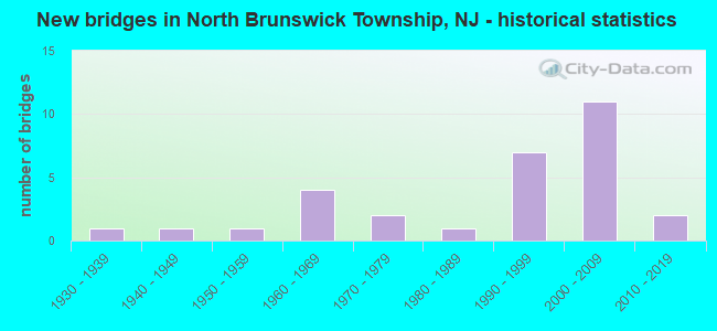
- New bridges - historical statistics
- 11930-1939
- 11940-1949
- 11950-1959
- 41960-1969
- 21970-1979
- 11980-1989
- 71990-1999
- 112000-2009
- 22010-2019


- Bridge Condition - Deck
- 8.3%Very good
- 41.7%Good
- 25.0%Satisfactory
- 8.3%Fair
- 8.3%Poor
- 8.3%Serious

- Bridge Condition - Superstructure
- 30.8%Very good
- 15.4%Good
- 30.8%Satisfactory
- 15.4%Fair
- 7.7%Poor

- Bridge Condition - Substructure
- 23.1%Very good
- 38.5%Good
- 23.1%Satisfactory
- 15.4%Fair

- Bridge Condition - Channel
- 37.5%Very good
- 12.5%Good
- 37.5%Satisfactory
- 12.5%Fair

- Bridge Condition - Culverts
- 25.0%Good
- 75.0%Satisfactory
Find on map >> Show street view
Structure Number: 1201158, Location: 1.7 M SOUTH OF US 130 (Lat: 40.454211, Lng: -74.487239), Route carried "on" structure: US 1, Year Built: 1994, Status: Open, Structure Length: 13.29m (43.60ft), Average Daily Traffic: 87,010 (year 2020), Truck Traffic: 4%, Average Future Daily Traffic: 117,200 (year 2040), Design Load: HS 25 or greater, Features Intersected: AMTRAK,LIVINGSTON&RAMPS
Minimum Vertical Clearance: 30.45m (99.90ft), Kilometerpoint: 37.095, Lanes on structure: 8, Lanes under structure: 4, Base Highway Network: Yes, Owner: State Highway Agency, Approaching Roadway Width: 32.9m (107.9ft), Skew: 35 degrees, Material/Design: Steel, Design/Construction: Stringer/Multi-beam, Number Of Spans In Main Unit: 3, Length of Maximum Span: 58.8m (192.9ft), Curb or Sidewalk Widths: Left: 1.8m (5.9ft), Right: 1.8m (5.9ft), Curb-To-Curb Width: 33.1m (108.6ft), Out-to-Out Width: 38.1m (125.0ft)
Condition: Deck: Good, Superstructure: Satisfactory, Substructure: Satisfactory, Operating Rating: 68.0 metric tons, Method Used To Determine Operating Rating: Load Factor (LF), Inventory Rating: 40.8 metric tons, Method Used To Determine Inventory Rating: Load Factor (LF), Structural Evaluation: Equal to present minimum criteria, Deck Geometry: Somewhat better than minimum adequacy, Underclear: Meets minimum limits, Approach Roadway Alignment: Equal to present desirable criteria, Designated Inspection Frequency: Every 24 months, Inspection Date: November 2020, Deck Structure Type: Concrete Cast-file-Place, Wearing Surface/Protective System: Wearing Surface: Latex Concrete, Deck Protection: Epoxy Coated Reinforcing
Find on map >> Show street view
Structure Number: 1202151, Location: 0.48 MI N OF US 130 (Lat: 40.464819, Lng: -74.448289), Route carried "on" structure: County highway 606, Year Built: 1960, Status: Open, Structure Length: 4.63m (15.19ft), Average Daily Traffic: 29,134 (year 2020), Truck Traffic: 3%, Average Future Daily Traffic: 34,961 (year 2040), Design Load: HS 20+Mod, Features Intersected: US 1
Minimum Vertical Clearance: 30+ m (98+ ft), Kilometerpoint: 7.113, Lanes on structure: 4, Lanes under structure: 8, Owner: State Highway Agency, Approaching Roadway Width: 19.5m (64.0ft), Skew: 22 degrees, Material/Design: Steel, Design/Construction: Stringer/Multi-beam, Number Of Spans In Main Unit: 2, Length of Maximum Span: 23.5m (77.1ft), Curb or Sidewalk Widths: Left: 2.4m (7.9ft), Right: 2.4m (7.9ft), Curb-To-Curb Width: 18.3m (60.0ft), Out-to-Out Width: 25.0m (82.0ft)
Condition: Deck: Poor, Superstructure: Poor, Substructure: Satisfactory, Operating Rating: 68.9 metric tons, Method Used To Determine Operating Rating: Load Factor (LF), Inventory Rating: 41.7 metric tons, Method Used To Determine Inventory Rating: Load Factor (LF), Structural Evaluation: Meets minimum limits, Deck Geometry: Somewhat better than minimum adequacy, Underclear: Somewhat better than minimum adequacy, Approach Roadway Alignment: Equal to present minimum criteria, Length Of Structure Improvement: 4.63m (15.19ft), Designated Inspection Frequency: Every 24 months, Inspection Date: August 2020, Bridge Improvement Cost: $298,000, Roadway Improvement Cost: $51,000, Total Project Cost: $3,480,000 ( Estimate for 2018), Deck Structure Type: Concrete Cast-file-Place, Wearing Surface/Protective System: Wearing Surface: Monolithic Concrete
Find on map >> Show street view
Structure Number: 1202152, Location: 1.0 MI. NORTH OF RT.130 (Lat: 40.467181, Lng: -74.438181), Route carried "on" structure: US 1, Year Built: 2010, Status: Open, Structure Length: 2.90m (9.51ft), Average Daily Traffic: 115,717 (year 2020), Truck Traffic: 4%, Average Future Daily Traffic: 138,860 (year 2040), Design Load: HL 93, Features Intersected: CONNECTOR ROAD
Minimum Vertical Clearance: 30+ m (98+ ft), Kilometerpoint: 41.312, Lanes on structure: 8, Lanes under structure: 4, Base Highway Network: Yes, Owner: State Highway Agency, Approaching Roadway Width: 38.1m (125.0ft), Skew: 30 degrees, Material/Design: Steel, Design/Construction: Stringer/Multi-beam, Number Of Spans In Main Unit: 1, Length of Maximum Span: 28.3m (92.8ft), Curb-To-Curb Width: 38.2m (125.3ft), Out-to-Out Width: 40.1m (131.6ft)
Condition: Deck: Very good, Superstructure: Very good, Substructure: Very good, Operating Rating: 59.6 metric tons, Method Used To Determine Operating Rating: Load and Resistance Factor Rating (LRFR) rating reported by rating factor(RF) method using HL-93 loadings, Inventory Rating: 46.0 metric tons, Method Used To Determine Inventory Rating: Load and Resistance Factor Rating (LRFR) rating reported by rating factor(RF) method using HL-93 loadings, Structural Evaluation: Equal to present desirable criteria, Deck Geometry: Superior to present desirable criteria, Underclear: Better than present minimum criteria, Approach Roadway Alignment: Better than present minimum criteria, Designated Inspection Frequency: Every 24 months, Inspection Date: August 2020, Deck Structure Type: Concrete Cast-file-Place, Wearing Surface/Protective System: Wearing Surface: Monolithic Concrete, Deck Protection: Epoxy Coated Reinforcing
Find on map >> Show street view
Structure Number: 1202155, Location: .77 MILES SOUTH OF RT. 18 (Lat: 40.474889, Lng: -74.427861), Route carried "on" structure: County highway 617, Year Built: 1968, Status: Open, Structure Length: 6.22m (20.41ft), Average Daily Traffic: 14,490 (year 2020), Truck Traffic: 4%, Average Future Daily Traffic: 17,390 (year 2040), Design Load: HS 20, Features Intersected: US 1
Minimum Vertical Clearance: 30+ m (98+ ft), Kilometerpoint: 10.589, Lanes on structure: 6, Lanes under structure: 8, Owner: State Highway Agency, Approaching Roadway Width: 23.2m (76.1ft), Skew: 33 degrees, Material/Design: Steel, Design/Construction: Stringer/Multi-beam, Number Of Spans In Main Unit: 2, Length of Maximum Span: 32.3m (106.0ft), Curb or Sidewalk Widths: Left: 1.8m (5.9ft), Right: 1.8m (5.9ft), Curb-To-Curb Width: 23.2m (76.1ft), Out-to-Out Width: 29.3m (96.1ft)
Condition: Deck: Fair, Superstructure: Satisfactory, Substructure: Good, Operating Rating: 78.9 metric tons, Method Used To Determine Operating Rating: Load Factor (LF), Inventory Rating: 47.2 metric tons, Method Used To Determine Inventory Rating: Load Factor (LF), Structural Evaluation: Equal to present minimum criteria, Deck Geometry: Meets minimum limits, Underclear: Meets minimum limits, Approach Roadway Alignment: Better than present minimum criteria, Designated Inspection Frequency: Every 24 months, Inspection Date: August 2020, Deck Structure Type: Concrete Cast-file-Place, Wearing Surface/Protective System: Wearing Surface: Monolithic Concrete
Find on map >> Show street view
Structure Number: 1202156, Location: 0.44 mi S of CR606 (Lat: 40.462539, Lng: -74.454650), Route carried "on" structure: Ramp US 1, Year Built: 2003, Status: Open, Structure Length: 17.10m (56.10ft), Average Daily Traffic: 26,688 (year 2019), Truck Traffic: 4%, Average Future Daily Traffic: 32,026 (year 2039), Design Load: HS 25 or greater, Features Intersected: US 1
Minimum Vertical Clearance: 30+ m (98+ ft), Kilometerpoint: 39.719, Lanes on structure: 2, Lanes under structure: 7, Owner: State Highway Agency, Approaching Roadway Width: 13.1m (43.0ft), Material/Design: Steel continuous, Design/Construction: Stringer/Multi-beam, Number Of Spans In Main Unit: 5, Length of Maximum Span: 41.5m (136.2ft), Curb-To-Curb Width: 13.2m (43.3ft), Out-to-Out Width: 14.2m (46.6ft)
Condition: Deck: Good, Superstructure: Very good, Substructure: Very good, Operating Rating: 68.9 metric tons, Method Used To Determine Operating Rating: Load Factor (LF), Inventory Rating: 40.8 metric tons, Method Used To Determine Inventory Rating: Load Factor (LF), Structural Evaluation: Equal to present desirable criteria, Deck Geometry: Superior to present desirable criteria, Underclear: Better than present minimum criteria, Approach Roadway Alignment: Equal to present desirable criteria, Designated Inspection Frequency: Every 24 months, Critical Feature Inspection Frequency: Every 24 months, Inspection Date: June 2021, Critical Feature Inspection Date: June 2021, Deck Structure Type: Concrete Cast-file-Place, Wearing Surface/Protective System: Wearing Surface: Monolithic Concrete, Deck Protection: Epoxy Coated Reinforcing
Find on map >> Show street view
Structure Number: 1227159, Location: 4.2 MI S OF 1-130 JCT (Lat: 40.416231, Lng: -74.501881), Route carried "on" structure: US 130, Year Built: 1934, Year Reconstructed: 1948, Status: Open, Structure Length: 0.88m (2.89ft), Average Daily Traffic: 40,450 (year 2020), Truck Traffic: 4%, Average Future Daily Traffic: 49,350 (year 2040), Features Intersected: OAKEYS BROOK
Minimum Vertical Clearance: 30+ m (98+ ft), Kilometerpoint: 127.380, Lanes on structure: 5, Base Highway Network: Yes, Owner: State Highway Agency, Approaching Roadway Width: 25.0m (82.0ft), Skew: 25 degrees, Material/Design: Concrete, Design/Construction: Slab, Number Of Spans In Main Unit: 1, Length of Maximum Span: 8.2m (26.9ft), Curb or Sidewalk Widths: Left: 1.8m (5.9ft), Right: 0.0m, Curb-To-Curb Width: 27.9m (91.5ft), Out-to-Out Width: 31.6m (103.7ft)
Condition: Superstructure: Fair, Substructure: Fair, Channel: Satisfactory, Operating Rating: 82.6 metric tons, Method Used To Determine Operating Rating: Load Factor (LF), Inventory Rating: 49.0 metric tons, Method Used To Determine Inventory Rating: Load Factor (LF), Structural Evaluation: Somewhat better than minimum adequacy, Deck Geometry: Superior to present desirable criteria, Waterway Adequacy: Superior to present desirable criteria, Approach Roadway Alignment: Equal to present desirable criteria, Length Of Structure Improvement: 0.88m (2.89ft), Designated Inspection Frequency: Every 24 months, Inspection Date: June 2020, Bridge Improvement Cost: $90,000, Total Project Cost: $190,000 ( Estimate for 2020)
Find on map >> Show street view
Structure Number: 1227163, Location: Over Route US 1 NB/SB (Lat: 40.461750, Lng: -74.454631), Route carried "on" structure: US 130, Year Built: 2003, Status: Open, Structure Length: 16.00m (52.49ft), Average Daily Traffic: 34,799 (year 2021), Truck Traffic: 4%, Average Future Daily Traffic: 41,758 (year 2041), Design Load: HL 93, Features Intersected: US 1 + Connectors
Minimum Vertical Clearance: 30+ m (98+ ft), Kilometerpoint: 134.187, Lanes on structure: 2, Lanes under structure: 12, Owner: State Highway Agency, Approaching Roadway Width: 16.2m (53.1ft), Material/Design: Steel continuous, Design/Construction: Stringer/Multi-beam, Number Of Spans In Main Unit: 5, Length of Maximum Span: 39.0m (128.0ft), Curb or Sidewalk Widths: Left: 0.0m, Right: 1.8m (5.9ft), Curb-To-Curb Width: 16.2m (53.1ft), Out-to-Out Width: 18.8m (61.7ft)
Condition: Deck: Good, Superstructure: Good, Substructure: Good, Operating Rating: 31.8 metric tons, Method Used To Determine Operating Rating: Load and Resistance Factor Rating (LRFR) rating reported by rating factor(RF) method using HL-93 loadings, Inventory Rating: 24.6 metric tons, Method Used To Determine Inventory Rating: Load and Resistance Factor Rating (LRFR) rating reported by rating factor(RF) method using HL-93 loadings, Structural Evaluation: Equal to present minimum criteria, Deck Geometry: Superior to present desirable criteria, Underclear: Somewhat better than minimum adequacy, Approach Roadway Alignment: Equal to present desirable criteria, Designated Inspection Frequency: Every 24 months, Critical Feature Inspection Frequency: Every 24 months, Inspection Date: June 2021, Critical Feature Inspection Date: June 2021, Deck Structure Type: Concrete Cast-file-Place, Wearing Surface/Protective System: Deck Protection: Epoxy Coated Reinforcing
Find on map >> Show street view
Structure Number: 1227164, Location: 2.7 miles south of Rt. 18 (Lat: 40.462989, Lng: -74.455619), Route carried "on" structure: US 130, Year Built: 2003, Status: Open, Structure Length: 7.59m (24.90ft), Average Daily Traffic: 27,750 (year 2021), Truck Traffic: 4%, Average Future Daily Traffic: 38,350 (year 2041), Design Load: HL 93, Features Intersected: US 1
Minimum Vertical Clearance: 30+ m (98+ ft), Kilometerpoint: 134.316, Lanes on structure: 3, Lanes under structure: 8, Base Highway Network: Yes, Owner: State Highway Agency, Approaching Roadway Width: 18.3m (60.0ft), Material/Design: Steel continuous, Design/Construction: Stringer/Multi-beam, Number Of Spans In Main Unit: 2, Length of Maximum Span: 37.5m (123.0ft), Curb or Sidewalk Widths: Left: 0.0m, Right: 1.8m (5.9ft), Curb-To-Curb Width: 18.3m (60.0ft), Out-to-Out Width: 20.9m (68.6ft)
Condition: Deck: Good, Superstructure: Very good, Substructure: Good, Operating Rating: 61.9 metric tons, Method Used To Determine Operating Rating: Load and Resistance Factor Rating (LRFR) rating reported by rating factor(RF) method using HL-93 loadings, Inventory Rating: 47.6 metric tons, Method Used To Determine Inventory Rating: Load and Resistance Factor Rating (LRFR) rating reported by rating factor(RF) method using HL-93 loadings, Structural Evaluation: Better than present minimum criteria, Deck Geometry: Superior to present desirable criteria, Underclear: Superior to present desirable criteria, Approach Roadway Alignment: Equal to present desirable criteria, Designated Inspection Frequency: Every 24 months, Inspection Date: September 2021, Deck Structure Type: Concrete Cast-file-Place, Wearing Surface/Protective System: Wearing Surface: Monolithic Concrete, Membrane: Epoxy, Deck Protection: Epoxy Coated Reinforcing
Find on map >> Show street view
Structure Number: 1227165, Location: US 1 and US 130 Jct. (Lat: 40.461031, Lng: -74.455050), Route carried "on" structure: Ramp US 1, Year Built: 2003, Status: Open, Structure Length: 3.05m (10.01ft), Average Daily Traffic: 5,960 (year 2020), Truck Traffic: 4%, Average Future Daily Traffic: 7,152 (year 2040), Design Load: HL 93, Features Intersected: US 130
Minimum Vertical Clearance: 30+ m (98+ ft), Kilometerpoint: 39.654, Lanes on structure: 5, Lanes under structure: 4, Owner: State Highway Agency, Approaching Roadway Width: 45.7m (149.9ft), Material/Design: Steel, Design/Construction: Stringer/Multi-beam, Number Of Spans In Main Unit: 1, Length of Maximum Span: 30.5m (100.1ft), Curb or Sidewalk Widths: Left: 3.4m (11.2ft), Right: 2.7m (8.9ft), Curb-To-Curb Width: 23.0m (75.5ft), Out-to-Out Width: 45.6m (149.6ft)
Condition: Deck: Good, Superstructure: Very good, Substructure: Very good, Operating Rating: 96.9 metric tons, Method Used To Determine Operating Rating: Load and Resistance Factor Rating (LRFR) rating reported by rating factor(RF) method using HL-93 loadings, Inventory Rating: 96.9 metric tons, Method Used To Determine Inventory Rating: Load and Resistance Factor Rating (LRFR) rating reported by rating factor(RF) method using HL-93 loadings, Structural Evaluation: Equal to present desirable criteria, Deck Geometry: Superior to present desirable criteria, Underclear: Somewhat better than minimum adequacy, Approach Roadway Alignment: Equal to present desirable criteria, Designated Inspection Frequency: Every 24 months, Inspection Date: Febuary 2020, Deck Structure Type: Concrete Cast-file-Place, Wearing Surface/Protective System: Deck Protection: Epoxy Coated Reinforcing
Find on map >> Show street view
Structure Number: 123B145, Location: 0.6 MILE EAST OF RTE 130 (Lat: 40.440189, Lng: -74.467531), Route carried "on" structure: City street , Year Built: 1995, Status: Open, Structure Length: 2.53m (8.30ft), Average Daily Traffic: 5,320 (year 2021), Truck Traffic: 1%, Average Future Daily Traffic: 6,490 (year 2041), Design Load: HS 20+Mod, Features Intersected: FARRINGTON LAKE, Facility Carried by Structure: WASHINGTON PLACE
Minimum Vertical Clearance: 30+ m (98+ ft), Kilometerpoint: 0.000, Lanes on structure: 2, Owner: County Highway Agency, Approaching Roadway Width: 9.1m (29.9ft), Material/Design: Prestressed concrete, Design/Construction: Box Beam or Girders - Multiple, Number Of Spans In Main Unit: 1, Length of Maximum Span: 24.1m (79.1ft), Curb or Sidewalk Widths: Left: 1.8m (5.9ft), Right: 0.9m (3.0ft), Curb-To-Curb Width: 9.1m (29.9ft), Out-to-Out Width: 12.6m (41.3ft)
Condition: Deck: Satisfactory, Superstructure: Good, Substructure: Good, Channel: Very good, Operating Rating: 68.9 metric tons, Method Used To Determine Operating Rating: Load Factor (LF), Inventory Rating: 40.8 metric tons, Method Used To Determine Inventory Rating: Load Factor (LF), Structural Evaluation: Better than present minimum criteria, Deck Geometry: High priority of corrective action, Waterway Adequacy: Equal to present desirable criteria, Approach Roadway Alignment: Equal to present desirable criteria, Length Of Structure Improvement: 2.53m (8.30ft), Designated Inspection Frequency: Every 24 months, Underwater Inspection Frequency: Every 48 months, Inspection Date: April 2021, Underwater Inspection Date: April 2021, Bridge Improvement Cost: $11,000, Roadway Improvement Cost: $77,000, Total Project Cost: $164,000 ( Estimate for 2021), Deck Structure Type: Concrete Cast-file-Place, Wearing Surface/Protective System: Wearing Surface: Monolithic Concrete, Deck Protection: Epoxy Coated Reinforcing
Find on map >> Show street view
Structure Number: 123B151, Location: 0.5 MI. SOUTH OF US 1 (Lat: 40.466989, Lng: -74.426819), Route carried "on" structure: County highway 617, Year Built: 1990, Status: Open, Structure Length: 2.71m (8.89ft), Average Daily Traffic: 11,880 (year 2021), Truck Traffic: 4%, Average Future Daily Traffic: 14,494 (year 2041), Design Load: HS 20+Mod, Features Intersected: WESTON MILL POND
Minimum Vertical Clearance: 30+ m (98+ ft), Kilometerpoint: 9.737, Lanes on structure: 4, Base Highway Network: Yes, Owner: County Highway Agency, Approaching Roadway Width: 21.3m (69.9ft), Skew: 10 degrees, Material/Design: Prestressed concrete, Design/Construction: Box Beam or Girders - Multiple, Number Of Spans In Main Unit: 1, Length of Maximum Span: 25.9m (85.0ft), Curb or Sidewalk Widths: Left: 1.7m (5.6ft), Right: 2.0m (6.6ft), Curb-To-Curb Width: 21.3m (69.9ft), Out-to-Out Width: 32.0m (105.0ft)
Condition: Deck: Satisfactory, Superstructure: Satisfactory, Substructure: Good, Channel: Very good, Operating Rating: 68.0 metric tons, Method Used To Determine Operating Rating: Load Factor (LF), Inventory Rating: 33.6 metric tons, Method Used To Determine Inventory Rating: Load Factor (LF), Structural Evaluation: Equal to present minimum criteria, Deck Geometry: Superior to present desirable criteria, Waterway Adequacy: Superior to present desirable criteria, Approach Roadway Alignment: Equal to present desirable criteria, Designated Inspection Frequency: Every 24 months, Underwater Inspection Frequency: Every 48 months, Inspection Date: June 2021, Underwater Inspection Date: July 2019, Deck Structure Type: Concrete Cast-file-Place, Wearing Surface/Protective System: Wearing Surface: Monolithic Concrete, Deck Protection: Epoxy Coated Reinforcing
Find on map >> Show street view
Structure Number: 1249165, Location: 0.21 MILES EAST OF US 1 (Lat: 40.447650, Lng: -74.490631), Route carried "on" structure: County highway 608, Year Built: 1955, Status: Open, Structure Length: 6.80m (22.31ft), Average Daily Traffic: 17,520 (year 2020), Truck Traffic: 4%, Average Future Daily Traffic: 23,600 (year 2040), Design Load: H 20, Features Intersected: AMTRAK NE CORRIDOR
Minimum Vertical Clearance: 30+ m (98+ ft), Kilometerpoint: 2.189, Lanes on structure: 2, Maintenance Responsibility: State Highway Agency, Approaching Roadway Width: 9.1m (29.9ft), Skew: 1 degrees, Material/Design: Steel, Design/Construction: Stringer/Multi-beam, Number Of Spans In Main Unit: 3, Length of Maximum Span: 25.3m (83.0ft), Curb or Sidewalk Widths: Left: 1.5m (4.9ft), Right: 0.4m (1.3ft), Curb-To-Curb Width: 9.1m (29.9ft), Out-to-Out Width: 11.5m (37.7ft)
Condition: Deck: Serious, Superstructure: Fair, Substructure: Fair, Operating Rating: 72.6 metric tons, Method Used To Determine Operating Rating: Load Factor (LF), Inventory Rating: 43.5 metric tons, Method Used To Determine Inventory Rating: Load Factor (LF), Structural Evaluation: Somewhat better than minimum adequacy, Deck Geometry: Meets minimum limits, Underclear: Somewhat better than minimum adequacy, Approach Roadway Alignment: Meets minimum limits, Length Of Structure Improvement: 6.80m (22.31ft), Designated Inspection Frequency: Every 24 months, Inspection Date: November 2020, Bridge Improvement Cost: $1,271,000, Roadway Improvement Cost: $127,000, Total Project Cost: $2,030,000 ( Estimate for 2020), Deck Structure Type: Concrete Cast-file-Place, Wearing Surface/Protective System: Wearing Surface: Bituminous
Find on map >> Show street view
Structure Number: 124B003, Location: 0.5 MILE WEST OF US 1 (Lat: 40.455689, Lng: -74.499281), Route carried "on" structure: County highway 608, Year Built: 1993, Status: Open, Structure Length: 0.67m (2.20ft), Average Daily Traffic: 14,470 (year 2021), Truck Traffic: 4%, Average Future Daily Traffic: 17,655 (year 2041), Design Load: HS 20+Mod, Features Intersected: SIX MILE RUN
Minimum Vertical Clearance: 30+ m (98+ ft), Kilometerpoint: 0.950, Lanes on structure: 2, Owner: County Highway Agency, Approaching Roadway Width: 15.8m (51.8ft), Skew: 2 degrees, Material/Design: Concrete, Design/Construction: Culvert, Number Of Spans In Main Unit: 1, Length of Maximum Span: 6.1m (20.0ft), Curb or Sidewalk Widths: Left: 0.0m, Right: 2.0m (6.6ft), Curb-To-Curb Width: 15.7m (51.5ft), Out-to-Out Width: 18.5m (60.7ft)
Condition: Channel: Satisfactory, Culverts: Satisfactory, Operating Rating: 86.2 metric tons, Method Used To Determine Operating Rating: Load Factor (LF), Inventory Rating: 51.7 metric tons, Method Used To Determine Inventory Rating: Load Factor (LF), Structural Evaluation: Equal to present minimum criteria, Deck Geometry: Superior to present desirable criteria, Waterway Adequacy: Equal to present desirable criteria, Approach Roadway Alignment: Equal to present desirable criteria, Designated Inspection Frequency: Every 24 months, Inspection Date: March 2021, Deck Structure Type: Concrete Cast-file-Place, Wearing Surface/Protective System: Deck Protection: Epoxy Coated Reinforcing
Find on map >> Show street view
Structure Number: 124B5, Location: 0.25 MI WEST OF US 130 (Lat: 40.416389, Lng: -74.505061), Route carried "on" structure: City street , Year Built: 1940, Status: Open, Structure Length: 0.76m (2.49ft), Average Daily Traffic: 275 (year 2021), Truck Traffic: 1%, Average Future Daily Traffic: 340 (year 2041), Features Intersected: OAKLEYS BROOK, Facility Carried by Structure: BLACK HORSE LANE
Minimum Vertical Clearance: 30+ m (98+ ft), Kilometerpoint: 0.000, Lanes on structure: 2, Owner: County Highway Agency, Approaching Roadway Width: 6.4m (21.0ft), Material/Design: Steel, Design/Construction: Culvert, Number Of Spans In Main Unit: 2, Length of Maximum Span: 3.7m (12.1ft), Curb-To-Curb Width: 7.9m (25.9ft), Out-to-Out Width: 11.5m (37.7ft)
Condition: Channel: Fair, Culverts: Satisfactory, Operating Rating: 41.7 metric tons, Method Used To Determine Operating Rating: Load Factor (LF), Inventory Rating: 35.4 metric tons, Method Used To Determine Inventory Rating: Load Factor (LF), Structural Evaluation: Equal to present minimum criteria, Deck Geometry: Somewhat better than minimum adequacy, Waterway Adequacy: Equal to present minimum criteria, Approach Roadway Alignment: Equal to present desirable criteria, Designated Inspection Frequency: Every 24 months, Inspection Date: March 2021
Find on map >> Show street view
Structure Number: 124B503, Location: 0.6 MILE WEST OF US 1 (Lat: 40.453811, Lng: -74.504969), Route carried "on" structure: Other road , Year Built: 1981, Status: Open, Structure Length: 0.82m (2.69ft), Average Daily Traffic: 1,990 (year 2021), Truck Traffic: 1%, Average Future Daily Traffic: 2,430 (year 2041), Features Intersected: SIX MILE RUN, Facility Carried by Structure: SCHMIDT LANE
Minimum Vertical Clearance: 30+ m (98+ ft), Kilometerpoint: 0.000, Lanes on structure: 2, Owner: County Highway Agency, Approaching Roadway Width: 11.0m (36.1ft), Material/Design: Steel, Design/Construction: Culvert, Number Of Spans In Main Unit: 1, Length of Maximum Span: 8.2m (26.9ft), Curb or Sidewalk Widths: Left: 1.8m (5.9ft), Right: 1.8m (5.9ft), Curb-To-Curb Width: 11.0m (36.1ft), Out-to-Out Width: 21.6m (70.9ft)
Condition: Channel: Satisfactory, Culverts: Satisfactory, Operating Rating: 59.9 metric tons, Method Used To Determine Operating Rating: Load Factor (LF), Inventory Rating: 47.2 metric tons, Method Used To Determine Inventory Rating: Load Factor (LF), Structural Evaluation: Equal to present minimum criteria, Deck Geometry: Equal to present minimum criteria, Waterway Adequacy: Equal to present desirable criteria, Approach Roadway Alignment: Equal to present desirable criteria, Designated Inspection Frequency: Every 24 months, Inspection Date: March 2021
Find on map >> Show street view
Structure Number: 124B53, Location: 0.5 mi S of Finnegan Lane (Lat: 40.434389, Lng: -74.530661), Route carried "on" structure: City street , Year Built: 1970, Status: Open, Structure Length: 1.40m (4.59ft), Average Daily Traffic: 1,675 (year 2021), Truck Traffic: 1%, Average Future Daily Traffic: 2,044 (year 2041), Design Load: HS 20, Features Intersected: OAKAYS BROOK, Facility Carried by Structure: KORY DRIVE
Minimum Vertical Clearance: 30+ m (98+ ft), Kilometerpoint: 0.000, Lanes on structure: 2, Owner: County Highway Agency, Approaching Roadway Width: 11.0m (36.1ft), Material/Design: Concrete continuous, Design/Construction: Slab, Number Of Spans In Main Unit: 2, Length of Maximum Span: 7.0m (23.0ft), Curb or Sidewalk Widths: Left: 2.4m (7.9ft), Right: 2.4m (7.9ft), Curb-To-Curb Width: 11.0m (36.1ft), Out-to-Out Width: 16.4m (53.8ft)
Condition: Deck: Satisfactory, Superstructure: Satisfactory, Substructure: Satisfactory, Channel: Very good, Operating Rating: 54.4 metric tons, Method Used To Determine Operating Rating: Field evaluation and documented engineering judgment, Inventory Rating: 32.7 metric tons, Method Used To Determine Inventory Rating: Field evaluation and documented engineering judgment, Structural Evaluation: Equal to present minimum criteria, Deck Geometry: Equal to present minimum criteria, Waterway Adequacy: Equal to present desirable criteria, Approach Roadway Alignment: Better than present minimum criteria, Designated Inspection Frequency: Every 24 months, Inspection Date: May 2021, Deck Structure Type: Concrete Cast-file-Place, Wearing Surface/Protective System: Wearing Surface: Bituminous
Find on map >> Show street view
Structure Number: 124B533, Location: 0.43 miles north of US 1 (Lat: 40.442239, Lng: -74.514200), Route carried "on" structure: City street , Year Built: 1970, Status: Open, Structure Length: 0.64m (2.10ft), Average Daily Traffic: 583 (year 2021), Truck Traffic: 1%, Average Future Daily Traffic: 712 (year 2041), Design Load: HS 20, Features Intersected: TRIB. OF SIX MILE RUN, Facility Carried by Structure: AARON ROAD
Minimum Vertical Clearance: 30.45m (99.90ft), Kilometerpoint: 0.000, Lanes on structure: 2, Owner: County Highway Agency, Approaching Roadway Width: 11.0m (36.1ft), Skew: 1 degrees, Material/Design: Concrete, Design/Construction: Culvert, Number Of Spans In Main Unit: 3, Length of Maximum Span: 1.8m (5.9ft), Curb or Sidewalk Widths: Left: 2.4m (7.9ft), Right: 2.5m (8.2ft), Curb-To-Curb Width: 11.0m (36.1ft), Out-to-Out Width: 16.5m (54.1ft)
Condition: Channel: Good, Culverts: Good, Operating Rating: 54.4 metric tons, Method Used To Determine Operating Rating: Field evaluation and documented engineering judgment, Inventory Rating: 32.7 metric tons, Method Used To Determine Inventory Rating: Field evaluation and documented engineering judgment, Structural Evaluation: Better than present minimum criteria, Deck Geometry: Better than present minimum criteria, Waterway Adequacy: Better than present minimum criteria, Approach Roadway Alignment: Equal to present desirable criteria, Designated Inspection Frequency: Every 24 months, Inspection Date: May 2021
Find on map >> Show street view
Structure Number: 1201158, Location: 1.7 M SOUTH OF US 130 (Lat: 40.454211, Lng: -74.487239), Route carried "under" structure: State highway 26, Year Built: 1994, Structure Length: 0. m, Average Daily Traffic: 15,950 (year 2020), Truck Traffic: 4%, Features Intersected: AMTRAK,LIVINGSTON&RAMPS, Facility Carried by Structure: US 1
Minimum Vertical Clearance: 7.85m (25.75ft), Kilometerpoint: 0.789, Lanes on structure: 8, Lanes under structure: 2, Material/Design: Steel, Design/Construction: Stringer/Multi-beam, Length of Maximum Span: 58.8m (192.9ft)
Find on map >> Show street view
Structure Number: 1201158, Location: 1.7 M SOUTH OF US 130 (Lat: 40.454211, Lng: -74.487239), Route carried "under" structure: Ramp US 1, Year Built: 1994, Structure Length: 0. m, Average Daily Traffic: 5,290 (year 2020), Features Intersected: AMTRAK,LIVINGSTON&RAMPS
Minimum Vertical Clearance: 6.71m (22.01ft), Kilometerpoint: 0.000, Lanes on structure: 8, Lanes under structure: 1, Material/Design: Steel, Design/Construction: Stringer/Multi-beam, Length of Maximum Span: 58.8m (192.9ft)
Find on map >> Show street view
Structure Number: 1201158, Location: 1.7 M SOUTH OF US 130 (Lat: 40.454211, Lng: -74.487239), Route carried "under" structure: Ramp City street 1, Year Built: 1994, Structure Length: 0. m, Average Daily Traffic: 5,290 (year 2020), Features Intersected: AMTRAK,LIVINGSTON&RAMPS
Minimum Vertical Clearance: 6.75m (22.15ft), Kilometerpoint: 0.000, Lanes on structure: 8, Lanes under structure: 1, Material/Design: Steel, Design/Construction: Stringer/Multi-beam, Length of Maximum Span: 58.8m (192.9ft)
Find on map >> Show street view
Structure Number: 1202151, Location: 0.48 MI N OF US 130 (Lat: 40.464819, Lng: -74.448289), Route carried "under" structure: US 1, Year Built: 1960, Structure Length: 0. m, Average Daily Traffic: 122,779 (year 2020), Truck Traffic: 4%, Features Intersected: US 1, Facility Carried by Structure: CR606(MILLTOWN RD)
Minimum Vertical Clearance: 4.50m (14.76ft), Kilometerpoint: 40.427, Lanes on structure: 4, Lanes under structure: 8, Material/Design: Steel, Design/Construction: Stringer/Multi-beam, Length of Maximum Span: 23.5m (77.1ft)
Find on map >> Show street view
Structure Number: 1202152, Location: 1.0 MI. NORTH OF RT.130 (Lat: 40.467181, Lng: -74.438181), Route carried "under" structure: Ramp City street , Year Built: 2010, Structure Length: 0. m, Average Daily Traffic: 2,614 (year 2020), Truck Traffic: 1%, Features Intersected: CONNECTOR ROAD, Facility Carried by Structure: US 1
Minimum Vertical Clearance: 4.88m (16.01ft), Kilometerpoint: 0.000, Lanes on structure: 8, Lanes under structure: 4, Material/Design: Steel, Design/Construction: Stringer/Multi-beam, Length of Maximum Span: 28.3m (92.8ft)
Find on map >> Show street view
Structure Number: 1202155, Location: .77 MILES SOUTH OF RT. 18 (Lat: 40.474889, Lng: -74.427861), Route carried "under" structure: US 1, Year Built: 1968, Structure Length: 0. m, Average Daily Traffic: 115,726 (year 2020), Truck Traffic: 4%, Features Intersected: US 1
Minimum Vertical Clearance: 5.72m (18.77ft), Kilometerpoint: 42.519, Lanes on structure: 6, Lanes under structure: 8, Material/Design: Steel, Design/Construction: Stringer/Multi-beam, Length of Maximum Span: 32.3m (106.0ft)
Find on map >> Show street view
Structure Number: 1202156, Location: 0.44 mi S of CR606 (Lat: 40.462539, Lng: -74.454650), Route carried "under" structure: Ramp US 130, Year Built: 2003, Structure Length: 0. m, Average Daily Traffic: 1,061 (year 2019), Truck Traffic: 4%, Features Intersected: US 1
Minimum Vertical Clearance: 7.56m (24.80ft), Kilometerpoint: 134.187, Lanes on structure: 2, Lanes under structure: 1, Material/Design: Steel continuous, Design/Construction: Stringer/Multi-beam, Length of Maximum Span: 41.5m (136.2ft)
Find on map >> Show street view
Structure Number: 1202156, Location: 0.44 mi S of CR606 (Lat: 40.462539, Lng: -74.454650), Route carried "under" structure: US 1, Year Built: 2003, Structure Length: 0. m, Average Daily Traffic: 102,787 (year 2019), Truck Traffic: 4%, Features Intersected: US 1
Minimum Vertical Clearance: 7.38m (24.21ft), Kilometerpoint: 39.654, Lanes on structure: 2, Lanes under structure: 6, Material/Design: Steel continuous, Design/Construction: Stringer/Multi-beam, Length of Maximum Span: 41.5m (136.2ft)
Find on map >> Show street view
Structure Number: 1227163, Location: Over Route US 1 NB/SB (Lat: 40.461750, Lng: -74.454631), Route carried "under" structure: US 1, Year Built: 2003, Structure Length: 0. m, Average Daily Traffic: 87,354 (year 2021), Truck Traffic: 4%, Features Intersected: US 1 + Connectors
Minimum Vertical Clearance: 9.47m (31.07ft), Kilometerpoint: 39.654, Lanes on structure: 2, Lanes under structure: 8, Material/Design: Steel continuous, Design/Construction: Stringer/Multi-beam, Length of Maximum Span: 39.0m (128.0ft)
Find on map >> Show street view
Structure Number: 1227163, Location: Over Route US 1 NB/SB (Lat: 40.461750, Lng: -74.454631), Route carried "under" structure: Ramp US 130, Year Built: 2003, Structure Length: 0. m, Average Daily Traffic: 1,082 (year 2021), Truck Traffic: 4%, Features Intersected: US 1 + Connectors
Minimum Vertical Clearance: 8.69m (28.51ft), Kilometerpoint: 134.091, Lanes on structure: 2, Lanes under structure: 2, Material/Design: Steel continuous, Design/Construction: Stringer/Multi-beam, Length of Maximum Span: 39.0m (128.0ft)
Find on map >> Show street view
Structure Number: 1227163, Location: Over Route US 1 NB/SB (Lat: 40.461750, Lng: -74.454631), Route carried "under" structure: Ramp US 1, Year Built: 2003, Structure Length: 0. m, Average Daily Traffic: 1,082 (year 2021), Truck Traffic: 4%, Features Intersected: US 1 + Connectors
Minimum Vertical Clearance: 5.82m (19.09ft), Kilometerpoint: 39.654, Lanes on structure: 2, Lanes under structure: 2, Material/Design: Steel continuous, Design/Construction: Stringer/Multi-beam, Length of Maximum Span: 39.0m (128.0ft)
Find on map >> Show street view
Structure Number: 1227164, Location: 2.7 miles south of Rt. 18 (Lat: 40.462989, Lng: -74.455619), Route carried "under" structure: US 1, Year Built: 2003, Structure Length: 0. m, Average Daily Traffic: 106,870 (year 2021), Truck Traffic: 4%, Features Intersected: US 1
Minimum Vertical Clearance: 7.52m (24.67ft), Kilometerpoint: 39.654, Lanes on structure: 3, Lanes under structure: 8, Material/Design: Steel continuous, Design/Construction: Stringer/Multi-beam, Length of Maximum Span: 37.5m (123.0ft)
Find on map >> Show street view
Structure Number: 1227165, Location: US 1 and US 130 Jct. (Lat: 40.461031, Lng: -74.455050), Route carried "under" structure: US 130, Year Built: 2003, Structure Length: 0. m, Average Daily Traffic: 8,342 (year 2020), Truck Traffic: 4%, Features Intersected: US 130, Facility Carried by Structure: RAMP (FROM US 1)
Minimum Vertical Clearance: 5.49m (18.01ft), Kilometerpoint: 134.010, Lanes on structure: 5, Lanes under structure: 4, Material/Design: Steel, Design/Construction: Stringer/Multi-beam, Length of Maximum Span: 30.5m (100.1ft)