Bridge Statistics for North Attleborough, Massachusetts (MA)
Condition, Traffic, Stress, Structural Evaluation, Project Costs
- National Bridge Inventory (NBI) Statistics
- 24Number of bridges
- 272ft / 83.0mTotal length
- $73,870,000Total costs
- 623,817Total average daily traffic
- 25,339Total average daily truck traffic
- National Bridge Inventory (NBI) Registered Bridges for North Attleborough
- No street view available for this location
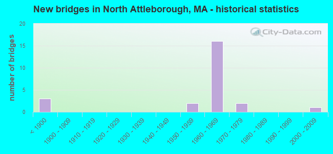
- New bridges - historical statistics
- 3Before 1900
- 21950-1959
- 161960-1969
- 21970-1979
- 12000-2009

- Reconstructed bridges - Historical Statistics
- 11930-1939
- 11940-1949
- 01950-1959
- 01960-1969
- 01970-1979
- 11980-1989
- 11990-1999


- Bridge Condition - Deck
- 5.3%Very good
- 15.8%Good
- 52.6%Satisfactory
- 21.1%Fair
- 5.3%Poor

- Bridge Condition - Superstructure
- 10.5%Good
- 52.6%Satisfactory
- 36.8%Fair

- Bridge Condition - Substructure
- 5.3%Very good
- 31.6%Good
- 47.4%Satisfactory
- 10.5%Fair
- 5.3%Poor

- Bridge Condition - Channel
- 14.3%Good
- 42.9%Satisfactory
- 28.6%Fair
- 14.3%Poor
Find on map >> Show street view
Structure Number: N160033JTMUNNBI, Location: .6 MI E RHODE ISLAND (Lat: 41.932742, Lng: -71.369575), Route carried "on" structure: City street , Year Built: 1886, Year Reconstructed: 1980, Status: Open, Structure Length: 1.31m (4.30ft), Average Daily Traffic: 2,800 (year 2018), Truck Traffic: 5%, Average Future Daily Traffic: 5,685 (year 2031), Design Load: HS 20, Features Intersected: WATER ABBOTT RUN RIVER, Facility Carried by Structure: HWY CUSHMAN RD
Minimum Vertical Clearance: 30+ m (98+ ft), Kilometerpoint: 0.451, Lanes on structure: 1, Owner: Town or Township Highway Agency, Approaching Roadway Width: 4.3m (14.1ft), Material/Design: Prestressed concrete, Design/Construction: Slab, Number Of Spans In Main Unit: 1, Length of Maximum Span: 12.5m (41.0ft), Curb-To-Curb Width: 4.3m (14.1ft), Out-to-Out Width: 6.6m (21.7ft)
Condition: Deck: Satisfactory, Superstructure: Satisfactory, Substructure: Satisfactory, Channel: Satisfactory, Operating Rating: 60.6 metric tons, Method Used To Determine Operating Rating: Allowable Stress (AS), Inventory Rating: 33.5 metric tons, Method Used To Determine Inventory Rating: Allowable Stress (AS), Structural Evaluation: Equal to present minimum criteria, Deck Geometry: High priority of replacement, Waterway Adequacy: Superior to present desirable criteria, Approach Roadway Alignment: Somewhat better than minimum adequacy, Length Of Structure Improvement: 2.00m (6.56ft), Designated Inspection Frequency: Every 24 months, Inspection Date: November 2020, Bridge Improvement Cost: $1,645,000, Roadway Improvement Cost: $165,000, Total Project Cost: $2,468,000 ( Estimate for 2022), Deck Structure Type: Concrete Precast Panels, Wearing Surface/Protective System: Wearing Surface: Bituminous, Membrane: Epoxy
Find on map >> Show street view
Structure Number: N160043JUMUNNBI, Location: AT JUNCT. DEPOT STREET (Lat: 41.928589, Lng: -71.372889), Route carried "on" structure: City street , Year Built: 1850, Year Reconstructed: 1953, Status: Open, Structure Length: 1.43m (4.69ft), Average Daily Traffic: 7,100 (year 2019), Truck Traffic: 3%, Average Future Daily Traffic: 17,372 (year 2031), Design Load: H 20, Features Intersected: WATER ABBOTT RUN RIVER, Facility Carried by Structure: HWY MENDON RD
Minimum Vertical Clearance: 30+ m (98+ ft), Kilometerpoint: 0.225, Lanes on structure: 2, Owner: Town or Township Highway Agency, Approaching Roadway Width: 9.1m (29.9ft), Material/Design: Steel, Design/Construction: Stringer/Multi-beam, Number Of Spans In Main Unit: 1, Length of Maximum Span: 13.1m (43.0ft), Curb or Sidewalk Widths: Left: 1.6m (5.2ft), Right: 0.4m (1.3ft), Curb-To-Curb Width: 9.1m (29.9ft), Out-to-Out Width: 11.8m (38.7ft)
Condition: Deck: Satisfactory, Superstructure: Satisfactory, Substructure: Poor, Channel: Poor, Operating Rating: 34.4 metric tons, Method Used To Determine Operating Rating: Allowable Stress (AS), Inventory Rating: 19.6 metric tons, Method Used To Determine Inventory Rating: Allowable Stress (AS), Structural Evaluation: Meets minimum limits, Deck Geometry: High priority of corrective action, Waterway Adequacy: Equal to present minimum criteria, Approach Roadway Alignment: Equal to present minimum criteria, Length Of Structure Improvement: 2.20m (7.22ft), Designated Inspection Frequency: Every 12 months, Underwater Inspection Frequency: Every 12 months, Inspection Date: November 2020, Underwater Inspection Date: March 2021, Bridge Improvement Cost: $1,856,000, Roadway Improvement Cost: $186,000, Total Project Cost: $2,785,000 ( Estimate for 2022), Deck Structure Type: Concrete Cast-file-Place, Wearing Surface/Protective System: Wearing Surface: Bituminous, Membrane: Built-up
Find on map >> Show street view
Structure Number: N16008830MUNNBI, Location: .5MI E OF MENDON RD (Lat: 41.944569, Lng: -71.371789), Route carried "on" structure: City street , Year Built: 2007, Status: Open, Structure Length: 2.10m (6.89ft), Average Daily Traffic: 2,100 (year 2021), Truck Traffic: 6%, Average Future Daily Traffic: 2,211 (year 2032), Design Load: HS 20, Features Intersected: WATER ABBOTT RUN RIVER, Facility Carried by Structure: HWY HUNTS BRG RD
Minimum Vertical Clearance: 30+ m (98+ ft), Kilometerpoint: 0.676, Lanes on structure: 2, Owner: Town or Township Highway Agency, Approaching Roadway Width: 7.7m (25.3ft), Material/Design: Steel, Design/Construction: Stringer/Multi-beam, Number Of Spans In Main Unit: 1, Length of Maximum Span: 20.7m (67.9ft), Curb-To-Curb Width: 7.6m (24.9ft), Out-to-Out Width: 8.4m (27.6ft)
Condition: Deck: Good, Superstructure: Good, Substructure: Good, Channel: Good, Operating Rating: 71.6 metric tons, Method Used To Determine Operating Rating: Load Factor (LF), Inventory Rating: 42.9 metric tons, Method Used To Determine Inventory Rating: Load Factor (LF), Structural Evaluation: Better than present minimum criteria, Deck Geometry: High priority of replacement, Waterway Adequacy: Better than present minimum criteria, Approach Roadway Alignment: Equal to present minimum criteria, Length Of Structure Improvement: 2.20m (7.22ft), Designated Inspection Frequency: Every 24 months, Inspection Date: October 2021, Bridge Improvement Cost: $1,204,000, Roadway Improvement Cost: $121,000, Total Project Cost: $1,807,000 ( Estimate for 2022), Deck Structure Type: Concrete Precast Panels, Wearing Surface/Protective System: Wearing Surface: Integral Concrete, Deck Protection: Epoxy Coated Reinforcing
Find on map >> Show street view
Structure Number: N1601596NDOTNBI, Location: INT.US1&ELM (Lat: 41.981111, Lng: -71.329667), Route carried "on" structure: US 1, Year Built: 1850, Year Reconstructed: 1930, Status: Open, Structure Length: 1.64m (5.38ft), Average Daily Traffic: 35,948 (year 2021), Truck Traffic: 5%, Features Intersected: WATER TEN MILE RIVER
Minimum Vertical Clearance: 30+ m (98+ ft), Kilometerpoint: 0.000, Lanes on structure: 8, Owner: State Highway Agency, Approaching Roadway Width: 24.0m (78.7ft), Skew: 17 degrees, Material/Design: Concrete, Design/Construction: Slab, Number Of Spans In Main Unit: 1, Length of Maximum Span: 14.8m (48.6ft), Curb or Sidewalk Widths: Left: 0.0m, Right: 1.8m (5.9ft), Curb-To-Curb Width: 24.0m (78.7ft), Out-to-Out Width: 25.9m (85.0ft)
Condition: Deck: Fair, Superstructure: Fair, Substructure: Satisfactory, Channel: Fair, Operating Rating: 52.0 metric tons, Method Used To Determine Operating Rating: Load Factor (LF), Inventory Rating: 31.1 metric tons, Method Used To Determine Inventory Rating: Load Factor (LF), Structural Evaluation: Somewhat better than minimum adequacy, Deck Geometry: High priority of replacement, Waterway Adequacy: Equal to present minimum criteria, Approach Roadway Alignment: Better than present minimum criteria, Length Of Structure Improvement: 1.70m (5.58ft), Designated Inspection Frequency: Every 18 months, Underwater Inspection Frequency: Every 18 months, Inspection Date: November 2021, Underwater Inspection Date: March 2021, Bridge Improvement Cost: $1,735,000, Roadway Improvement Cost: $174,000, Total Project Cost: $2,603,000 ( Estimate for 2022), Deck Structure Type: Concrete Cast-file-Place, Wearing Surface/Protective System: Wearing Surface: Bituminous
Find on map >> Show street view
Structure Number: N160163JVMUNNBI, Location: ADJACENT TO ROUTE 1 (Lat: 41.982919, Lng: -71.328444), Route carried "on" structure: City street , Year Built: 1979, Status: Open, Structure Length: 0.70m (2.30ft), Average Daily Traffic: 7,700 (year 2020), Truck Traffic: 5%, Average Future Daily Traffic: 10,265 (year 2031), Design Load: H 20, Features Intersected: WATER TEN MILE RIVER, Facility Carried by Structure: HWY ORNE ST/LNDY
Minimum Vertical Clearance: 30+ m (98+ ft), Kilometerpoint: 0.322, Lanes on structure: 2, Owner: Town or Township Highway Agency, Approaching Roadway Width: 12.2m (40.0ft), Material/Design: Prestressed concrete, Design/Construction: Slab, Number Of Spans In Main Unit: 1, Length of Maximum Span: 6.4m (21.0ft), Curb or Sidewalk Widths: Left: 2.0m (6.6ft), Right: 1.8m (5.9ft), Curb-To-Curb Width: 12.1m (39.7ft), Out-to-Out Width: 16.4m (53.8ft)
Condition: Deck: Fair, Superstructure: Fair, Substructure: Good, Channel: Fair, Operating Rating: 58.7 metric tons, Method Used To Determine Operating Rating: Load Factor (LF), Inventory Rating: 35.2 metric tons, Method Used To Determine Inventory Rating: Load Factor (LF), Structural Evaluation: Somewhat better than minimum adequacy, Deck Geometry: Somewhat better than minimum adequacy, Waterway Adequacy: Superior to present desirable criteria, Approach Roadway Alignment: Equal to present desirable criteria, Length Of Structure Improvement: 0.80m (2.62ft), Designated Inspection Frequency: Every 24 months, Inspection Date: November 2020, Bridge Improvement Cost: $516,000, Roadway Improvement Cost: $52,000, Total Project Cost: $775,000 ( Estimate for 2022), Deck Structure Type: Concrete Precast Panels, Wearing Surface/Protective System: Wearing Surface: Bituminous, Membrane: Built-up
Find on map >> Show street view
Structure Number: N160233LUMUNNBI, Location: .1 MI E OF CLIFTON ST (Lat: 41.960914, Lng: -71.307567), Route carried "on" structure: City street , Year Built: 1978, Status: Open, Structure Length: 1.10m (3.61ft), Average Daily Traffic: 650 (year 2016), Truck Traffic: 10%, Average Future Daily Traffic: 632 (year 2031), Design Load: H 20, Features Intersected: WATER TEN MILE RIVER, Facility Carried by Structure: HWY CEDAR RD
Minimum Vertical Clearance: 30+ m (98+ ft), Kilometerpoint: 0.000, Lanes on structure: 2, Owner: Town or Township Highway Agency, Approaching Roadway Width: 6.1m (20.0ft), Material/Design: Concrete continuous, Design/Construction: Slab, Number Of Spans In Main Unit: 3, Length of Maximum Span: 3.4m (11.2ft), Curb or Sidewalk Widths: Left: 1.5m (4.9ft), Right: 0.6m (2.0ft), Curb-To-Curb Width: 6.1m (20.0ft), Out-to-Out Width: 9.0m (29.5ft)
Condition: Deck: Good, Superstructure: Good, Substructure: Good, Channel: Satisfactory, Operating Rating: 74.5 metric tons, Method Used To Determine Operating Rating: Load Factor (LF), Inventory Rating: 45.4 metric tons, Method Used To Determine Inventory Rating: Load Factor (LF), Structural Evaluation: Better than present minimum criteria, Deck Geometry: High priority of corrective action, Waterway Adequacy: Equal to present desirable criteria, Approach Roadway Alignment: Equal to present desirable criteria, Length Of Structure Improvement: 1.20m (3.94ft), Designated Inspection Frequency: Every 24 months, Inspection Date: August 2020, Bridge Improvement Cost: $691,000, Roadway Improvement Cost: $70,000, Total Project Cost: $1,037,000 ( Estimate for 2022), Deck Structure Type: Concrete Cast-file-Place, Wearing Surface/Protective System: Wearing Surface: Bituminous
Find on map >> Show street view
Structure Number: N160463VNDOTNBI, Location: .2 MILES SOUTH PLAINVILL (Lat: 41.995892, Lng: -71.291967), Route carried "on" structure: State highway 152, Year Built: 1959, Year Reconstructed: 2004, Status: Open, Structure Length: 13.62m (44.69ft), Average Daily Traffic: 30,388 (year 2018), Truck Traffic: 5%, Average Future Daily Traffic: 33,165 (year 2032), Design Load: HS 20, Features Intersected: I 95
Minimum Vertical Clearance: 30+ m (98+ ft), Kilometerpoint: 19.786, Lanes on structure: 2, Lanes under structure: 6, Owner: State Highway Agency, Approaching Roadway Width: 13.4m (44.0ft), Skew: 5 degrees, Material/Design: Steel, Design/Construction: Stringer/Multi-beam, Number Of Spans In Main Unit: 5, Length of Maximum Span: 37.6m (123.4ft), Curb or Sidewalk Widths: Left: 1.8m (5.9ft), Right: 1.8m (5.9ft), Curb-To-Curb Width: 13.4m (44.0ft), Out-to-Out Width: 18.3m (60.0ft)
Condition: Deck: Very good, Superstructure: Satisfactory, Substructure: Very good, Operating Rating: 66.1 metric tons, Method Used To Determine Operating Rating: Load Factor (LF), Inventory Rating: 42.4 metric tons, Method Used To Determine Inventory Rating: Load Factor (LF), Structural Evaluation: Equal to present minimum criteria, Deck Geometry: Equal to present minimum criteria, Underclear: High priority of corrective action, Approach Roadway Alignment: Better than present minimum criteria, Length Of Structure Improvement: 13.70m (44.95ft), Designated Inspection Frequency: Every 24 months, Inspection Date: November 2020, Bridge Improvement Cost: $1,970,000, Roadway Improvement Cost: $198,000, Total Project Cost: $2,956,000 ( Estimate for 2022), Deck Structure Type: Concrete Cast-file-Place, Wearing Surface/Protective System: Wearing Surface: Bituminous, Membrane: Built-up
Find on map >> Show street view
Structure Number: N160473VJDOTNBI, Location: .1 MI N OF ATTLEBORO T.L. (Lat: 41.969253, Lng: -71.295772), Route carried "on" structure: City street , Year Built: 1960, Status: Open, Structure Length: 9.08m (29.79ft), Average Daily Traffic: 32,327 (year 2021), Truck Traffic: 8%, Average Future Daily Traffic: 54,012 (year 2032), Design Load: HS 20+Mod, Features Intersected: I 95, Facility Carried by Structure: HWY TONER BLVD
Minimum Vertical Clearance: 30+ m (98+ ft), Kilometerpoint: 0.000, Lanes on structure: 4, Lanes under structure: 7, Owner: State Highway Agency, Approaching Roadway Width: 15.8m (51.8ft), Skew: 1 degrees, Material/Design: Steel, Design/Construction: Stringer/Multi-beam, Number Of Spans In Main Unit: 4, Length of Maximum Span: 34.4m (112.9ft), Curb or Sidewalk Widths: Left: 0.7m (2.3ft), Right: 1.8m (5.9ft), Curb-To-Curb Width: 15.8m (51.8ft), Out-to-Out Width: 19.6m (64.3ft)
Condition: Deck: Poor, Superstructure: Fair, Substructure: Satisfactory, Operating Rating: 52.6 metric tons, Method Used To Determine Operating Rating: Load Factor (LF), Inventory Rating: 29.0 metric tons, Method Used To Determine Inventory Rating: Load Factor (LF), Structural Evaluation: Somewhat better than minimum adequacy, Deck Geometry: Meets minimum limits, Underclear: High priority of corrective action, Approach Roadway Alignment: Better than present minimum criteria, Length Of Structure Improvement: 9.10m (29.86ft), Designated Inspection Frequency: Every 12 months, Other Special Inspection Frequency: Every 12 months, Inspection Date: November 2021, Other Special Inspection Date: November 2021, Bridge Improvement Cost: $7,006,000, Roadway Improvement Cost: $701,000, Total Project Cost: $10,510,000 ( Estimate for 2022), Deck Structure Type: Concrete Cast-file-Place, Wearing Surface/Protective System: Wearing Surface: Bituminous, Membrane: Built-up
Find on map >> Show street view
Structure Number: N160493R5DOTNBI, Location: .2 MI SW OF MANSFLD T.L. (Lat: 42.006431, Lng: -71.284742), Route carried "on" structure: Interstate 95, Year Built: 1962, Status: Open, Structure Length: 4.42m (14.50ft), Average Daily Traffic: 62,245 (year 2019), Truck Traffic: 5%, Average Future Daily Traffic: 85,598 (year 2032), Design Load: HS 20+Mod, Features Intersected: HWY PLAIN ST
Minimum Vertical Clearance: 30+ m (98+ ft), Kilometerpoint: 15.449, Lanes on structure: 3, Lanes under structure: 2, Base Highway Network: Yes, Owner: State Highway Agency, Approaching Roadway Width: 15.2m (49.9ft), Skew: 3 degrees, Material/Design: Steel, Design/Construction: Stringer/Multi-beam, Number Of Spans In Main Unit: 3, Length of Maximum Span: 20.7m (67.9ft), Curb or Sidewalk Widths: Left: 0.5m (1.6ft), Right: 0.5m (1.6ft), Curb-To-Curb Width: 15.2m (49.9ft), Out-to-Out Width: 17.1m (56.1ft)
Condition: Deck: Satisfactory, Superstructure: Fair, Substructure: Satisfactory, Operating Rating: 47.2 metric tons, Method Used To Determine Operating Rating: Load Factor (LF), Inventory Rating: 28.3 metric tons, Method Used To Determine Inventory Rating: Load Factor (LF), Structural Evaluation: Somewhat better than minimum adequacy, Deck Geometry: Meets minimum limits, Underclear: Somewhat better than minimum adequacy, Approach Roadway Alignment: Better than present minimum criteria, Length Of Structure Improvement: 4.50m (14.76ft), Designated Inspection Frequency: Every 24 months, Inspection Date: Febuary 2021, Bridge Improvement Cost: $3,023,000, Roadway Improvement Cost: $303,000, Total Project Cost: $4,535,000 ( Estimate for 2022), Deck Structure Type: Concrete Cast-file-Place, Wearing Surface/Protective System: Wearing Surface: Bituminous, Membrane: Built-up
Find on map >> Show street view
Structure Number: N160493R6DOTNBI, Location: .2 MI SW OF MANSFLD T.L. (Lat: 42.006464, Lng: -71.285519), Route carried "on" structure: Interstate 95, Year Built: 1962, Status: Open, Structure Length: 4.33m (14.21ft), Average Daily Traffic: 62,090 (year 2019), Truck Traffic: 6%, Average Future Daily Traffic: 85,598 (year 2032), Design Load: HS 20+Mod, Features Intersected: HWY PLAIN ST
Minimum Vertical Clearance: 30+ m (98+ ft), Kilometerpoint: 15.449, Lanes on structure: 3, Lanes under structure: 2, Base Highway Network: Yes, Owner: State Highway Agency, Approaching Roadway Width: 15.2m (49.9ft), Skew: 3 degrees, Material/Design: Steel, Design/Construction: Stringer/Multi-beam, Number Of Spans In Main Unit: 3, Length of Maximum Span: 19.8m (65.0ft), Curb-To-Curb Width: 15.2m (49.9ft), Out-to-Out Width: 17.1m (56.1ft)
Condition: Deck: Satisfactory, Superstructure: Satisfactory, Substructure: Fair, Operating Rating: 47.2 metric tons, Method Used To Determine Operating Rating: Load Factor (LF), Inventory Rating: 28.3 metric tons, Method Used To Determine Inventory Rating: Load Factor (LF), Structural Evaluation: Somewhat better than minimum adequacy, Deck Geometry: Meets minimum limits, Underclear: Somewhat better than minimum adequacy, Approach Roadway Alignment: Equal to present desirable criteria, Length Of Structure Improvement: 4.40m (14.44ft), Designated Inspection Frequency: Every 24 months, Inspection Date: Febuary 2021, Bridge Improvement Cost: $2,956,000, Roadway Improvement Cost: $296,000, Total Project Cost: $4,435,000 ( Estimate for 2022), Deck Structure Type: Concrete Cast-file-Place, Wearing Surface/Protective System: Wearing Surface: Bituminous, Membrane: Built-up
Find on map >> Show street view
Structure Number: N160503UVDOTNBI, Location: .7 MI SE OF R.I.S.L. (Lat: 41.950731, Lng: -71.368156), Route carried "on" structure: Interstate 295, Year Built: 1966, Status: Open, Structure Length: 3.75m (12.30ft), Average Daily Traffic: 30,337 (year 2019), Truck Traffic: 5%, Average Future Daily Traffic: 47,379 (year 2031), Design Load: HS 20+Mod, Features Intersected: HWY PAINE RD
Minimum Vertical Clearance: 30+ m (98+ ft), Kilometerpoint: 1.127, Lanes on structure: 3, Lanes under structure: 2, Base Highway Network: Yes, Owner: State Highway Agency, Approaching Roadway Width: 15.2m (49.9ft), Skew: 3 degrees, Material/Design: Steel, Design/Construction: Stringer/Multi-beam, Number Of Spans In Main Unit: 3, Length of Maximum Span: 18.9m (62.0ft), Curb or Sidewalk Widths: Left: 0.2m (0.7ft), Right: 0.5m (1.6ft), Curb-To-Curb Width: 15.2m (49.9ft), Out-to-Out Width: 16.9m (55.4ft)
Condition: Deck: Satisfactory, Superstructure: Satisfactory, Substructure: Satisfactory, Operating Rating: 53.1 metric tons, Method Used To Determine Operating Rating: Load Factor (LF), Inventory Rating: 32.2 metric tons, Method Used To Determine Inventory Rating: Load Factor (LF), Structural Evaluation: Equal to present minimum criteria, Deck Geometry: Meets minimum limits, Underclear: Meets minimum limits, Approach Roadway Alignment: Equal to present desirable criteria, Length Of Structure Improvement: 3.80m (12.47ft), Designated Inspection Frequency: Every 24 months, Inspection Date: March 2020, Bridge Improvement Cost: $2,523,000, Roadway Improvement Cost: $253,000, Total Project Cost: $3,785,000 ( Estimate for 2022), Deck Structure Type: Concrete Cast-file-Place, Wearing Surface/Protective System: Wearing Surface: Bituminous, Membrane: Built-up
Find on map >> Show street view
Structure Number: N160503UWDOTNBI, Location: .7 MI SE OF R.I.S.L. (Lat: 41.950400, Lng: -71.367978), Route carried "on" structure: Interstate 295, Year Built: 1966, Status: Open, Structure Length: 3.69m (12.11ft), Average Daily Traffic: 29,400 (year 2019), Truck Traffic: 2%, Average Future Daily Traffic: 55,276 (year 2033), Design Load: HS 20, Features Intersected: HWY PAINE RD
Minimum Vertical Clearance: 30+ m (98+ ft), Kilometerpoint: 1.127, Lanes on structure: 3, Lanes under structure: 2, Base Highway Network: Yes, Owner: State Highway Agency, Approaching Roadway Width: 15.2m (49.9ft), Skew: 3 degrees, Material/Design: Steel, Design/Construction: Stringer/Multi-beam, Number Of Spans In Main Unit: 3, Length of Maximum Span: 18.6m (61.0ft), Curb or Sidewalk Widths: Left: 0.0m, Right: 0.5m (1.6ft), Curb-To-Curb Width: 15.2m (49.9ft), Out-to-Out Width: 16.9m (55.4ft)
Condition: Deck: Satisfactory, Superstructure: Satisfactory, Substructure: Fair, Operating Rating: 54.2 metric tons, Method Used To Determine Operating Rating: Load Factor (LF), Inventory Rating: 32.5 metric tons, Method Used To Determine Inventory Rating: Load Factor (LF), Structural Evaluation: Somewhat better than minimum adequacy, Deck Geometry: Meets minimum limits, Underclear: Meets minimum limits, Approach Roadway Alignment: Equal to present desirable criteria, Length Of Structure Improvement: 3.70m (12.14ft), Designated Inspection Frequency: Every 24 months, Inspection Date: March 2020, Bridge Improvement Cost: $2,457,000, Roadway Improvement Cost: $246,000, Total Project Cost: $3,686,000 ( Estimate for 2022), Deck Structure Type: Concrete Cast-file-Place, Wearing Surface/Protective System: Wearing Surface: Bituminous, Membrane: Built-up
Find on map >> Show street view
Structure Number: N160523Y5DOTNBI, Location: BEHIND EMERALD SQ MALL (Lat: 41.949558, Lng: -71.353975), Route carried "on" structure: City street , Year Built: 1966, Status: Open, Structure Length: 8.84m (29.00ft), Average Daily Traffic: 1,900 (year 2021), Truck Traffic: 6%, Average Future Daily Traffic: 14,687 (year 2032), Design Load: HS 20, Features Intersected: I 295, Facility Carried by Structure: HWY ALLEN AVE
Minimum Vertical Clearance: 30+ m (98+ ft), Kilometerpoint: 2.173, Lanes on structure: 2, Lanes under structure: 6, Owner: State Highway Agency, Approaching Roadway Width: 9.8m (32.2ft), Skew: 3 degrees, Material/Design: Steel, Design/Construction: Stringer/Multi-beam, Number Of Spans In Main Unit: 5, Length of Maximum Span: 22.3m (73.2ft), Curb or Sidewalk Widths: Left: 0.8m (2.6ft), Right: 2.2m (7.2ft), Curb-To-Curb Width: 9.8m (32.2ft), Out-to-Out Width: 12.7m (41.7ft)
Condition: Deck: Fair, Superstructure: Satisfactory, Substructure: Satisfactory, Operating Rating: 45.1 metric tons, Method Used To Determine Operating Rating: Load Factor (LF), Inventory Rating: 27.0 metric tons, Method Used To Determine Inventory Rating: Load Factor (LF), Structural Evaluation: Equal to present minimum criteria, Deck Geometry: Somewhat better than minimum adequacy, Underclear: High priority of corrective action, Approach Roadway Alignment: Equal to present desirable criteria, Length Of Structure Improvement: 8.90m (29.20ft), Designated Inspection Frequency: Every 24 months, Inspection Date: December 2021, Bridge Improvement Cost: $4,440,000, Roadway Improvement Cost: $445,000, Total Project Cost: $6,661,000 ( Estimate for 2022), Deck Structure Type: Concrete Cast-file-Place, Wearing Surface/Protective System: Wearing Surface: Bituminous, Membrane: Built-up
Find on map >> Show street view
Structure Number: N160533UTDOTNBI, Location: 2 MI. W. OF I-95 (Lat: 41.949381, Lng: -71.345744), Route carried "on" structure: Interstate 295, Year Built: 1966, Status: Open, Structure Length: 5.00m (16.40ft), Average Daily Traffic: 30,400 (year 2019), Truck Traffic: 2%, Average Future Daily Traffic: 64,593 (year 2031), Design Load: HS 20, Features Intersected: US 1 S WASHINGTON ST
Minimum Vertical Clearance: 30+ m (98+ ft), Kilometerpoint: 3.058, Lanes on structure: 4, Lanes under structure: 6, Base Highway Network: Yes, Owner: State Highway Agency, Approaching Roadway Width: 15.8m (51.8ft), Skew: 1 degrees, Material/Design: Steel, Design/Construction: Stringer/Multi-beam, Number Of Spans In Main Unit: 3, Length of Maximum Span: 29.9m (98.1ft), Curb or Sidewalk Widths: Left: 0.5m (1.6ft), Right: 0.5m (1.6ft), Curb-To-Curb Width: 15.8m (51.8ft), Out-to-Out Width: 17.7m (58.1ft)
Condition: Deck: Satisfactory, Superstructure: Satisfactory, Substructure: Good, Operating Rating: 56.9 metric tons, Method Used To Determine Operating Rating: Load Factor (LF), Inventory Rating: 34.1 metric tons, Method Used To Determine Inventory Rating: Load Factor (LF), Structural Evaluation: Equal to present minimum criteria, Deck Geometry: High priority of replacement, Underclear: Meets minimum limits, Approach Roadway Alignment: Equal to present desirable criteria, Length Of Structure Improvement: 5.10m (16.73ft), Designated Inspection Frequency: Every 24 months, Inspection Date: June 2020, Bridge Improvement Cost: $3,030,000, Roadway Improvement Cost: $304,000, Total Project Cost: $4,546,000 ( Estimate for 2022), Deck Structure Type: Concrete Cast-file-Place, Wearing Surface/Protective System: Wearing Surface: Bituminous, Membrane: Built-up
Find on map >> Show street view
Structure Number: N160533UUDOTNBI, Location: 2 MILES WEST OF I 95 (Lat: 41.949056, Lng: -71.345858), Route carried "on" structure: Interstate 295, Year Built: 1966, Status: Open, Structure Length: 5.00m (16.40ft), Average Daily Traffic: 29,359 (year 2019), Truck Traffic: 5%, Average Future Daily Traffic: 37,903 (year 2031), Design Load: HS 20, Features Intersected: US 1 S WASHINGTON ST
Minimum Vertical Clearance: 30+ m (98+ ft), Kilometerpoint: 3.058, Lanes on structure: 4, Lanes under structure: 6, Base Highway Network: Yes, Owner: State Highway Agency, Approaching Roadway Width: 15.8m (51.8ft), Skew: 1 degrees, Material/Design: Steel, Design/Construction: Stringer/Multi-beam, Number Of Spans In Main Unit: 3, Length of Maximum Span: 29.9m (98.1ft), Curb or Sidewalk Widths: Left: 0.5m (1.6ft), Right: 0.5m (1.6ft), Curb-To-Curb Width: 15.8m (51.8ft), Out-to-Out Width: 17.7m (58.1ft)
Condition: Deck: Satisfactory, Superstructure: Satisfactory, Substructure: Good, Operating Rating: 57.1 metric tons, Method Used To Determine Operating Rating: Load Factor (LF), Inventory Rating: 34.2 metric tons, Method Used To Determine Inventory Rating: Load Factor (LF), Structural Evaluation: Equal to present minimum criteria, Deck Geometry: High priority of replacement, Underclear: High priority of corrective action, Approach Roadway Alignment: Equal to present desirable criteria, Length Of Structure Improvement: 5.10m (16.73ft), Designated Inspection Frequency: Every 24 months, Inspection Date: June 2020, Bridge Improvement Cost: $3,030,000, Roadway Improvement Cost: $304,000, Total Project Cost: $4,546,000 ( Estimate for 2022), Deck Structure Type: Concrete Cast-file-Place, Wearing Surface/Protective System: Wearing Surface: Bituminous, Membrane: Built-up
Find on map >> Show street view
Structure Number: N160543URDOTNBI, Location: .2 MI E OF US 1 (Lat: 41.949397, Lng: -71.341800), Route carried "on" structure: Interstate 295, Year Built: 1966, Status: Open, Structure Length: 0.64m (2.10ft), Average Daily Traffic: 46,386 (year 2018), Truck Traffic: 6%, Average Future Daily Traffic: 63,172 (year 2032), Design Load: HS 20+Mod, Features Intersected: WATER SEVEN MILE RIVER
Minimum Vertical Clearance: 30+ m (98+ ft), Kilometerpoint: 3.378, Lanes on structure: 8, Base Highway Network: Yes, Owner: State Highway Agency, Approaching Roadway Width: 36.6m (120.1ft), Skew: 21 degrees, Material/Design: Concrete, Design/Construction: Culvert, Number Of Spans In Main Unit: 2, Length of Maximum Span: 3.0m (9.8ft)
Condition: Channel: Satisfactory, Culverts: Good, Structural Evaluation: Better than present minimum criteria, Waterway Adequacy: Equal to present desirable criteria, Approach Roadway Alignment: Equal to present desirable criteria, Length Of Structure Improvement: 0.10m (0.33ft), Designated Inspection Frequency: Every 24 months, Underwater Inspection Frequency: Every 36 months, Inspection Date: September 2021, Underwater Inspection Date: March 2021, Bridge Improvement Cost: $58,000, Roadway Improvement Cost: $6,000, Total Project Cost: $88,000 ( Estimate for 2022)
Find on map >> Show street view
Structure Number: N160553UPDOTNBI, Location: .3 MI E OF US1 (Lat: 41.949461, Lng: -71.339875), Route carried "on" structure: Interstate 295, Year Built: 1967, Status: Open, Structure Length: 3.44m (11.29ft), Average Daily Traffic: 20,200 (year 2019), Truck Traffic: 6%, Average Future Daily Traffic: 68,384 (year 2033), Design Load: HS 20, Features Intersected: HWY OLD POST RD
Minimum Vertical Clearance: 30+ m (98+ ft), Kilometerpoint: 3.540, Lanes on structure: 4, Lanes under structure: 2, Base Highway Network: Yes, Owner: State Highway Agency, Approaching Roadway Width: 15.8m (51.8ft), Skew: 2 degrees, Material/Design: Steel, Design/Construction: Stringer/Multi-beam, Number Of Spans In Main Unit: 3, Length of Maximum Span: 18.0m (59.1ft), Curb or Sidewalk Widths: Left: 0.5m (1.6ft), Right: 0.5m (1.6ft), Curb-To-Curb Width: 15.8m (51.8ft), Out-to-Out Width: 17.7m (58.1ft)
Condition: Deck: Good, Superstructure: Fair, Substructure: Satisfactory, Operating Rating: 57.3 metric tons, Method Used To Determine Operating Rating: Load Factor (LF), Inventory Rating: 34.3 metric tons, Method Used To Determine Inventory Rating: Load Factor (LF), Structural Evaluation: Somewhat better than minimum adequacy, Deck Geometry: High priority of replacement, Underclear: Meets minimum limits, Approach Roadway Alignment: Equal to present minimum criteria, Length Of Structure Improvement: 3.50m (11.48ft), Designated Inspection Frequency: Every 24 months, Inspection Date: Febuary 2022, Bridge Improvement Cost: $2,434,000, Roadway Improvement Cost: $244,000, Total Project Cost: $3,652,000 ( Estimate for 2022), Deck Structure Type: Concrete Cast-file-Place, Wearing Surface/Protective System: Wearing Surface: Bituminous, Membrane: Built-up
Find on map >> Show street view
Structure Number: N160553UQDOTNBI, Location: .3 MI. E. OF US1 (Lat: 41.949800, Lng: -71.339733), Route carried "on" structure: Interstate 295, Year Built: 1967, Status: Open, Structure Length: 3.38m (11.09ft), Average Daily Traffic: 26,233 (year 2019), Truck Traffic: 7%, Average Future Daily Traffic: 68,384 (year 2033), Design Load: HS 20, Features Intersected: HWY OLD POST RD
Minimum Vertical Clearance: 30+ m (98+ ft), Kilometerpoint: 3.540, Lanes on structure: 4, Lanes under structure: 2, Base Highway Network: Yes, Owner: State Highway Agency, Approaching Roadway Width: 15.2m (49.9ft), Skew: 2 degrees, Material/Design: Steel, Design/Construction: Stringer/Multi-beam, Number Of Spans In Main Unit: 3, Length of Maximum Span: 18.0m (59.1ft), Curb or Sidewalk Widths: Left: 0.5m (1.6ft), Right: 0.5m (1.6ft), Curb-To-Curb Width: 15.2m (49.9ft), Out-to-Out Width: 17.1m (56.1ft)
Condition: Deck: Satisfactory, Superstructure: Satisfactory, Substructure: Satisfactory, Operating Rating: 59.0 metric tons, Method Used To Determine Operating Rating: Load Factor (LF), Inventory Rating: 35.3 metric tons, Method Used To Determine Inventory Rating: Load Factor (LF), Structural Evaluation: Equal to present minimum criteria, Deck Geometry: High priority of replacement, Underclear: Meets minimum limits, Approach Roadway Alignment: Equal to present desirable criteria, Length Of Structure Improvement: 3.40m (11.15ft), Designated Inspection Frequency: Every 24 months, Inspection Date: Febuary 2022, Bridge Improvement Cost: $2,212,000, Roadway Improvement Cost: $222,000, Total Project Cost: $3,319,000 ( Estimate for 2022), Deck Structure Type: Concrete Cast-file-Place, Wearing Surface/Protective System: Wearing Surface: Bituminous, Membrane: Built-up
Find on map >> Show street view
Structure Number: N160563UMDOTNBI, Location: 1.2 MI W OF I 95 (Lat: 41.952242, Lng: -71.325531), Route carried "on" structure: Interstate 295, Year Built: 1967, Status: Open, Structure Length: 4.75m (15.58ft), Average Daily Traffic: 20,154 (year 2019), Truck Traffic: 5%, Average Future Daily Traffic: 39,482 (year 2032), Design Load: HS 20, Features Intersected: HWY MT HOPE ST
Minimum Vertical Clearance: 30+ m (98+ ft), Kilometerpoint: 4.989, Lanes on structure: 3, Lanes under structure: 2, Base Highway Network: Yes, Owner: State Highway Agency, Approaching Roadway Width: 15.2m (49.9ft), Skew: 4 degrees, Material/Design: Steel, Design/Construction: Stringer/Multi-beam, Number Of Spans In Main Unit: 3, Length of Maximum Span: 22.6m (74.1ft), Curb or Sidewalk Widths: Left: 0.5m (1.6ft), Right: 0.5m (1.6ft), Curb-To-Curb Width: 15.2m (49.9ft), Out-to-Out Width: 17.1m (56.1ft)
Condition: Deck: Satisfactory, Superstructure: Fair, Substructure: Satisfactory, Operating Rating: 59.1 metric tons, Method Used To Determine Operating Rating: Load Factor (LF), Inventory Rating: 35.4 metric tons, Method Used To Determine Inventory Rating: Load Factor (LF), Structural Evaluation: Somewhat better than minimum adequacy, Deck Geometry: Meets minimum limits, Underclear: Somewhat better than minimum adequacy, Approach Roadway Alignment: Equal to present desirable criteria, Length Of Structure Improvement: 4.80m (15.75ft), Designated Inspection Frequency: Every 24 months, Inspection Date: Febuary 2021, Bridge Improvement Cost: $3,225,000, Roadway Improvement Cost: $323,000, Total Project Cost: $4,838,000 ( Estimate for 2022), Deck Structure Type: Concrete Cast-file-Place, Wearing Surface/Protective System: Wearing Surface: Bituminous, Membrane: Built-up
Find on map >> Show street view
Structure Number: N160563UNDOTNBI, Location: 1.2 MI W OF I 95 (Lat: 41.952625, Lng: -71.325269), Route carried "on" structure: Interstate 295, Year Built: 1967, Status: Open, Structure Length: 4.75m (15.58ft), Average Daily Traffic: 27,000 (year 2019), Truck Traffic: 2%, Average Future Daily Traffic: 37,903 (year 2032), Design Load: HS 20+Mod, Features Intersected: HWY MT HOPE ST
Minimum Vertical Clearance: 30+ m (98+ ft), Kilometerpoint: 4.989, Lanes on structure: 3, Lanes under structure: 2, Base Highway Network: Yes, Owner: State Highway Agency, Approaching Roadway Width: 15.2m (49.9ft), Skew: 4 degrees, Material/Design: Steel, Design/Construction: Stringer/Multi-beam, Number Of Spans In Main Unit: 3, Length of Maximum Span: 22.6m (74.1ft), Curb or Sidewalk Widths: Left: 0.5m (1.6ft), Right: 0.5m (1.6ft), Curb-To-Curb Width: 15.2m (49.9ft), Out-to-Out Width: 17.1m (56.1ft)
Condition: Deck: Fair, Superstructure: Fair, Substructure: Good, Operating Rating: 59.1 metric tons, Method Used To Determine Operating Rating: Load Factor (LF), Inventory Rating: 35.4 metric tons, Method Used To Determine Inventory Rating: Load Factor (LF), Structural Evaluation: Somewhat better than minimum adequacy, Deck Geometry: Meets minimum limits, Underclear: Somewhat better than minimum adequacy, Approach Roadway Alignment: Equal to present desirable criteria, Length Of Structure Improvement: 4.80m (15.75ft), Designated Inspection Frequency: Every 24 months, Inspection Date: Febuary 2021, Bridge Improvement Cost: $3,225,000, Roadway Improvement Cost: $323,000, Total Project Cost: $4,838,000 ( Estimate for 2022), Deck Structure Type: Concrete Cast-file-Place, Wearing Surface/Protective System: Wearing Surface: Bituminous, Membrane: Built-up
Find on map >> Show street view
Structure Number: N160463VNDOTNBI, Location: ST 152 AT I 95 (Lat: 42.000000, Lng: -71.300000), Route carried "under" structure: Interstate 95, Year Built: 1959, Structure Length: 0. m, Average Daily Traffic: 46,900 (year 0000), Features Intersected: I 95 NB, Facility Carried by Structure: ST152
Minimum Vertical Clearance: 0.00m, Kilometerpoint: 0.000, Lanes on structure: 4, Lanes under structure: 4, Material/Design: Steel, Design/Construction: Stringer/Multi-beam, Length of Maximum Span: 37.5m (123.0ft)
Find on map >> Show street view
Structure Number: N160473VJDOTNBI, Location: 081089 STATUTORY (Lat: 41.966667, Lng: -71.300000), Route carried "under" structure: Interstate 95, Year Built: 1960, Structure Length: 0. m, Average Daily Traffic: 46,900 (year 0000), Features Intersected: I 95 NB, Facility Carried by Structure: HWY TONER BLVD
Minimum Vertical Clearance: 5.03m (16.50ft), Kilometerpoint: 0.000, Lanes on structure: 4, Lanes under structure: 4, Material/Design: Steel, Design/Construction: Stringer/Multi-beam, Length of Maximum Span: 34.4m (112.9ft)
Find on map >> Show street view
Structure Number: N160523Y5DOTNBI, Location: 1.5 MI SE OF R.I.S.L. (Lat: 41.950000, Lng: -71.366667), Route carried "under" structure: Interstate 295, Year Built: 1966, Structure Length: 0. m, Average Daily Traffic: 12,650 (year 0000), Features Intersected: I 295 NB, Facility Carried by Structure: HWY ALLEN AVE
Minimum Vertical Clearance: 5.08m (16.67ft), Kilometerpoint: 0.000, Lanes on structure: 4, Lanes under structure: 2, Material/Design: Steel, Design/Construction: Stringer/Multi-beam, Length of Maximum Span: 17.7m (58.1ft)
Find on map >> Show street view
Structure Number: N160523Y5DOTNBI, Location: 000066 STATUTORY (Lat: 41.950000, Lng: -71.366667), Route carried "under" structure: Interstate 295, Year Built: 1966, Structure Length: 0. m, Average Daily Traffic: 12,650 (year 0000), Features Intersected: I 295 SB, Facility Carried by Structure: HWY ALLEN AVE
Minimum Vertical Clearance: 5.08m (16.67ft), Kilometerpoint: 0.000, Lanes on structure: 4, Lanes under structure: 2, Material/Design: Steel, Design/Construction: Stringer/Multi-beam, Length of Maximum Span: 17.7m (58.1ft)